A Thesis Proposal Presented. Lucas Jonathan Reusser. The Faculty of the Geology Department. The University of Vermont.
|
|
|
- August Robinson
- 5 years ago
- Views:
Transcription
1 USING COSMOGENIC NUCLIDES TO DETERMINE THE TIMING, SPATIAL PATTERN, AND RATE OF FLUVIAL INCISION WITHIN BEDROCK CHANNELS OF THE SUSQUEHANNA RIVER, PENNSYLVANIA A Thesis Proposal Presented by Lucas Jonathan Reusser to The Faculty of the Geology Department of The University of Vermont September, 2002 Accepted by the Faculty of the Geology Department, the University of Vermont in partial fulfillment of the requirements for the degree of Masters of Science specializing in Geology. The following members of the Thesis Committee have read and approved this document before it was circulated to the faculty: (Advisor) Paul R. Bierman Date Accepted:
2 1.0 Abstract: I will investigate the timing, spatial patterning and rate of bedrock fluvial incision in Holtwood Gorge along the Susquehanna River, Pennsylvania using cosmogenic nuclides. The Gorge, located approximately 50 km upstream from Chesapeake Bay into which the Susquehanna River empties, displays at least three levels of bedrock terraces (straths) ideal for the application of cosmogenic dating techniques. The overall aim of my research is to develop a new application of cosmogenic dating in order to investigate the relationship between ancient, passive margin river levels, represented by the strath terraces, and otherwise documented changes in climate, land level and sea level during the late Quaternary. I have conducted a high level GPS survey of Holtwood Gorge and collected 64 samples from water-polished bedrock surfaces representing all three prominent strath levels. I have constructed a detailed field map correlating surfaces using field observations, GPS data, aerial photographs and topographic maps. Paleo-river gradients have been calculated and graphically represented. I have purified quartz from the majority of my samples. Exposure ages will be modeled from measured nuclide activities using standard altitude and longitude correction factors. The spatial patterning of erosion and vertical rates of incision will be compared to Pleistocene sea-level fluctuations, global ice volume estimates, the oxygen deep-sea isotope record and models of North American isostatic adjustment in an attempt to decipher how passive margin rivers respond to such external forces. 2.0 Introduction: Large rivers draining the North American Atlantic passive margin (the Susquehanna, Potomac, Rappahannock, and James) have incised deep channels into bedrock of the Piedmont Province over the past several million years (Pazzaglia et al., 1998). The Susquehanna River, as it flows from its headwaters in the central Appalachian Mountains to the Chesapeake Bay, has cut flights of bedrock terraces (straths) that are preserved within, and along the sides of gorges in its lower reaches (Thompson and Sevon, 2001; Figure 1). Most workers believe fluvial terraces represent adjustments made by a river in reaction to external changes including climate fluctuations or isostasy (Bull, 1990; Engel et al., 1996; Pazzaglia and Gardner, 1994b). Thus, strath terraces, if they can be dated, are potentially useful tools for investigating the interaction between glaciation, fluvial processes, glacial isostasy and eustasy in the eastern United Stated during the Quaternary (Engel et al., 1996). 1
3 The rate at which passive margin bedrock rivers erode rock, and the ultimate causes and timing of this incision are poorly understood (Tinkler and Wohl, 1998), because, until recently, direct dating of the bedrock terraces left behind has not been possible. Measurement of cosmogenic nuclide activities by accelerator mass spectrometry (Elmore and Phillips, 1987) now provides an opportunity to estimate exposure ages of bedrock surfaces exposed by fluvial erosion (Bierman, 1994). I will measure 10 Be and some 26 Al activities in quartz extracted from approximately 80 bedrock samples collected from terraces within the lower reaches of the Susquehanna River in order to understand terrace exposure history and thus infer behavior of the river over time. The physical process by which these rivers carve through their bedrock channels, leaving behind flights of strath terraces is uncertain. A model proposed by E-an Zen (1997a; 1997b) for the formation of similar strath terraces along the Potomac River, near Washington, DC, involves the headward migration of knickpoints, forming a cataractgorge system through Great Falls Park. Along the Susquehanna River, the formation of potholes, which exploit natural weaknesses in the bedrock, could have aided in the propagation of such knickpoints (Thompson and Sevon, 2001; Figure 2 & 3e). 3.0 Primary Objectives: This study will utilize cosmogenic nuclide analysis and interpretive modeling of approximately 80 samples collected from within the Susquehanna River basin in order to: determine the nuclide activity and model the exposure age of at least three levels of river terraces within the lower reaches of the Susquehanna River, determine both the vertical and longitudinal rate at which the Susquehanna River incised bedrock during the carving of Holtwood Gorge, determine whether this incision can be correlated to otherwise documented changes in climate and resulting effects, as well as glacial isostasy throughout the Pleistocene, refine this new application of cosmogenic nuclides by investigating the spatial pattern of nuclide activity at various scales on bedrock fluvial landforms in order to understand better the dynamics of erosion and exposure in passive margin, bedrock river systems. 2
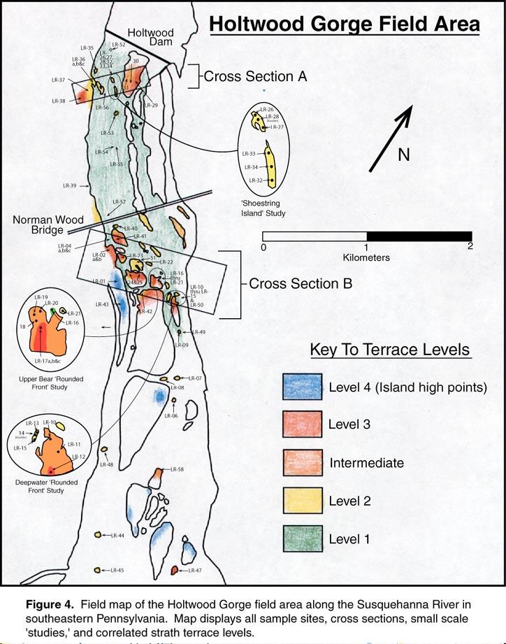
4 4.0 Study Site: 4.1 Susquehanna River: The Susquehanna River extends for more than 500 km (Engel et al., 1996) as it drains approximately 62,000 km 2 (Pazzaglia et al., 1998) of the Appalachian plateau and Piedmont Province in New York State, eastern Pennsylvania and northeastern Maryland. With a mean annual discharge of 1053 m 3 /s and peak annual discharge of 8610 m 3 /s (USGS Stream Flow Data from Gauging Station at Marietta, PA ( )) into the Chesapeake Bay, the Susquehanna is the largest drainage system of the Appalachian Mountain chain (Thompson, 1990). In northeastern and northcentral Pennsylvania, the Susquehanna generally exhibits a dendritic drainage pattern (Scharnberger, 1990) with broad, shallow channels and an average stream gradient of 0.5 m km -1 (Pazzaglia and Gardner, 1993, 1994a). In its lower reaches, the Susquehanna narrows and deepens as it cuts through the Wissahickon Schist of the high Piedmont. Its gradient steepens to an average of 1 m km -1 and it exhibits a strongly convex-up longitudinal profile (Pazzaglia and Gardner, 1993, 1994b). 4.2 Holtwood Gorge: Holtwood Gorge, located approximately 50 km upstream of Chesapeake Bay and immediately downstream from Holtwood Dam, is carved approximately 120 m (Thompson and Sevon, 2001) into the Wissahickon Schist and harbors at least three distinct levels of striking bedrock terraces which are preserved along the sides of the gorge and as isolated bedrock islands (dissected straths) within the gorge (Figures 4 & 3a through 3d). The uppermost level, which is restricted primarily to the western bank of the Susquehanna River and to island tops in the lower gorge, consists of heavily weathered accordant summits. I am uncertain if these summits represent abandoned fluvial surfaces. Intermediate levels (2 & 3) still preserve a fluvially sculptured form and, in some cases, can be correlated nearly 5 km downstream. The lowest strath is visible and accessible only at times when Holtwood Dam is not releasing water. This level exists as an expansive and planar surface stretching from the dam almost 2 km downstream on the western two-thirds of the river. In general, this surface is more ragged and less sculptured than the intermediate levels, suggesting that a period of time is required for surfaces to acquire a water worn appearance. 3
5 Enormous potholes, ranging in size from several cm in depth and diameter to nearly 9 m in depth and 4-6 m in diameter, are abundant within the gorge (Figure 3e). These potholes, which dip upstream and develop at the intersection of the NE-striking foliation and a NNW-striking joint set, suggest that erosion and removal of material from the gorge was efficiently accomplished by quarrying of large bedrock blocks (Thompson and Sevon, 2001). The Wissahickon Schist dips steeply downstream and contains abundant boudins of almost pure quartz. The well preserved bedrock terrace levels and ubiquitous quartz, well suited for sample collection and processing, make Holtwood Gorge an ideal location to utilize cosmogenic dating techniques. 5.0 Previous Work: The Susquehanna River basin, the southern half of which has remained free of ice during all Pliocene and Pleistocene glaciations, offers the opportunity to study a variety of proximate and distal glaciofluvial features not present in unglaciated or fully glaciated basins. For this reason, sequences of glacial moraines in northeastern Pennsylvania, river terraces preserved south of the glacial margin, and coastal deposits have been extensively studied in an effort to decipher the effect of glaciation and/or other climate perturbations on passive margin river systems. 5.1 Glacial Chronology of Pennsylvania: Evidence for nine periods of glaciation, ranging in age from older than the Pliocene/ Pleistocene transition (1.65 mya) to the late Wisconsin glaciation (35-10 kya) can be found within the U.S. (Richmond and Fullerton, 1986). However, tills from only three of these glacial periods are preserved in northeastern Pennsylvania, through which the North and West Branches of the Susquehanna River flow. Radiocarbon dating has constrained the age of the Late Wisconsin glacial advance to 17 k to 22 k 14 C years in Pennsylvania, with a maximum extent at about 20 k years (Braun, 1988; Sevon and Fleeger, 1999). Two older moraines, not overrun by the late Wisconsin advance, have been identified and assigned general ages through comparison to the oxygen isotope record and the Matuyamma-Brunhes magnetic polarity reversal. A swath of unnamed till across northeastern Pennsylvania correlates to the Titusville Till in western Pennsylvania and has been assigned an age of late-illinoian ( 132 ka-198 ka; Sevon and Fleeger, 1999). The oldest of the 4
6 Pennsylvanian tills extends approximately 50 km further south from the late-illinoian moraine and is overlain by lake clays displaying a reversed polarity signature. The age of this till can only be constrained to sometime between the last two polarity reversals. It has been assigned a poorly constrained age of pre-illinoian ( 788 ka-2400 ka; Richmond and Fullerton, 1986; Sevon and Fleeger, 1999). 5.2 Fluvial Terraces and the Susquehanna River: Fluvial terraces presumably represent changes in climate as well as periods of isostatic adjustment, and are therefore useful tools for investigating the interaction between glaciation, fluvial processes and eustasy in the Eastern U.S. during the Quaternary (Bull, 1990; Engel et al., 1996; Hancock et al., 1999). Many researchers have studied fluvial terraces of the Susquehanna River in order to investigate the geomorphic evolution of the U.S. Atlantic passive margin, beginning primarily with an extensive study conducted by Peltier (1949). Correlation between a series of upland terraces ( m above the modern channel) and coastal plain and fall zone deposits was used to establish terrace ages throughout the Piedmont Province of Pennsylvania in an attempt to quantify late Cenozoic passive margin deformation (Pazzaglia and Gardner, 1993, 1994a, b). Flights of younger (Pleistocene) alluvial terraces were identified and studied for the purpose of establishing soil chronosequences in order to facilitate correlation to similar features found elsewhere in the middle Atlantic region (Engel et al., 1996). Based on soil development characteristics, several of the six identified alluvial terraces, located upstream from the Holtwood Gorge field area, were tentatively correlated to the late Wisconsin, Illinoian, and pre-illinoian glacial advances in Pennsylvania. However, no definite age control was established for the alluvial terraces. No such correlation or dating has been rigorously attempted on the bedrock straths preserved in Holtwood Gorge. 5.3 Cosmogenic Nuclides: The continual bombardment of Earth s surface by secondary cosmic rays (primarily neutrons) results in the steady production and accumulation of cosmogenic nuclides within exposed rock and sediment (Lal and Peters, 1967). The in-situ production rate of these nuclides depends upon the strength of Earth s magnetic field and thickness of the overlying atmosphere at any given point on Earth s surface (Lal, 1991). As a result, latitude and altitude corrections must be made when transforming measured nuclide concentrations into exposure ages (Lal, 1991). This study 5
7 will utilize two radioactive cosmogenic isotopes, 10 Be and 26 Al, which result from the spallation of O and Si respectively, in order the obtain exposure ages of bedrock surfaces. Cosmogenic nuclides have been employed in a variety of geomorphic studies since the mid 1980 s. Nuclide activities have been used to obtain exposure ages of glacial boulders (Evenson and Goose, 1993; Marsella et al., 2000; Nishiizumi et al., 1989), estimate landscape erosion rates (Bierman and Caffee, 2001, 2002; Granger et al., 1996, 1997), calculate rates of sediment transport (Bierman and Steig, 1996; Nichols et al., 2002), and suggest depostional histories (Anderson et al., 1996; Granger and Muzikar, 2001). Although 10 Be and 26 Al have been used in many studies to date alluvial terraces (e.g., Hancock et al., 1999; Repka et al., 1997), only 3 studies have been conducted on bedrock (strath) terraces (Burbank et al., 1996; Leland et al., 1994; Leland et al., 1998), all in the Himalaya on rapidly downcutting rivers in an active tectonic setting. 6.0 Work Plan: My work thus far has, and will continue to focus on Holtwood Gorge because of the flights of well preserved and extensive strath terraces, relatively easy accessibility afforded by Holtwood Dam, and the abundance of extractable quartz. 6.1 Field Work: Working with Eric Butler as my field assistant, I spent approximately four weeks within Holtwood gorge scouting every available surface for the most representative and accessible sample sites and conducting a comprehensive Trimble 4400 differential GPS (offering cm resolution) survey for the purpose of lateral and longitudinal correlation of identified terrace levels. In order to ensure the accuracy of GPS data, I established a series of control points along the length of the gorge and measured them daily. I used a hammer and chisel to collect 64 samples composed of quartz boudins or schist groundmass from the selected water polished surfaces of the Wissahickon Schist. Altitude, latitude, sample thickness, and exposure geometry were recorded in order to make the appropriate production rate corrections (Lal, 1991). I employed a nested sampling strategy in order to investigate isotopic activity variance on what I interpret to be single terrace levels, at small (5-10 m), medium (cross-stream, 500 m), and large (downstream, up to 5 km) spatial scales (Figures 4 & 5). 6
8 6.2 Map and Laboratory Work: I constructed a field map delineating all correlated dissected strath terraces and sample-site locations using aerial photographs and high accuracy elevation GPS data collected from Holtwood Gorge (Figure 4). I have calculated and constructed trend surface plots of each terrace level in order to depict the downstream gradient that occurs over the five kilometers spanned by the gorge (Figure 6). Most samples have already undergone the first step in processing at the University of Vermont using standard techniques (Bierman and Caffee, 2001). I have purified 40 g of quartz through the use of acid etching and density separation (Kohl and Nishiizumi, 1992). I will assist Jennifer Larsen in the isolation of 26 Al & 10 Be in the cosmogenic laboratory as it is prepared for isotopic measurement by accelerator mass spectrometry at the Lawrence Livermore National Laboratory in Livermore, California. Two full laboratory replicates will be run to test for accuracy and reproducibility of sample preparation and nuclide concentration measurement. 10 Be will be measured for all samples while paired nuclide analysis ( 26 Al and 10 Be) will be conducted on several samples for quality control and to rule out extended (>100 ky) periods of burial, which appear geomorphically unlikely. 6.3 Data Analysis: Nuclide activities will be analyzed in an attempt to decipher the spatial patterning, timing, and rates of bedrock incision as well as to infer the erosional processes responsible for carving Holtwood Gorge. Measured nuclide activities for all samples will be reduced to exposure ages using the altitude-latitude scaling function presented in Lal (1991). Exposure ages will be plotted against distance downstream from the dam front for all terrace levels in order to determine rates of knickpoint propagation (if this is indeed the how the gorge incised). Terrace level exposure ages from samples collected in cross-section will be used to calculated rates of vertical incision between levels. The spatial pattern of erosion for each correlated strath will be investigated using small and medium scale nuclide activity variance. Statistical analysis will be applied to all small, medium, and large scale sampling strategies to determine the power with which conclusions can be drawn. Finally, the modeled erosional history of Holtwood Gorge will be compared to the Pleistocene glacial chronology of Pennsylvania (Braun, 1988, 1994) and the northern hemisphere (Richmond 7
9 and Fullerton, 1986), the Pleistocene sea level record, and the glacial forebulge model in the hopes of understanding the timing and ultimate causes of episodic incision recorded as bedrock terraces within the gorge. 7.0 Time Line: Work Completed To Date: May and June, 2002: Scout and map Holtwood gorge field area. Select potential sample sites. Conduct Pro XR GPS survey within the gorge. June, 2002: Field check sample sites with Paul Bierman and collect samples from all terrace levels except the lowest strath (underwater at this time of year). July, 2002: Visit with Paul Bierman and Milan Pavich of the USGS for mapping and sample collection at the Mather Gorge site on the Potomac River. July, 2002: Collect samples from the now exposed lower strath and collect high accuracy (cm) 4400 GPS data for all sample sites. August 2002: Quartz making at the University of Vermont. Continue background reading, construct air photo maps, construct Susquehanna Project webpage and, finish writing proposal and prepare defense presentation. Fall 2002 Sept. or Oct., 2002: Proposal Oral Defense. Sept. and Oct., 2002: Continue quartz making and chemical isolation of 26 Al and 10 Be at the University of Vermont cosmogenic laboratory with Jen Larsen. Oct.,2002: Present poster on the Potomac River project at the GSA Annual meeting in Denver, Colorado. Nov., 2002: Return to Holtwood Gorge for follow-up sampling and GPS work on sites previously under leaf cover. Dec., 2002: Initial Mass Spectrometer measurement of sample nuclide concentrations at the Lawrence Livermore National Laboratory. Continue research and background reading. Spring 2003 AMS measurement of most samples. Submit written progress report in March. Present progress report oral defense. Begin writing thesis. Possible presentation at Spring AGU meeting Conduct follow-up sampling and/or GPS work as needed. Summer 2003 Return to Holtwood Gorge and field check all sample sites. Continue writing thesis. Salary supported by grant 8
10 Fall 2003 RA supported. Complete thesis and begin edits. Present at GSA annual meeting. 8.0 Discussion of Preliminary Data: Data collected during my first season of field work has been analyzed and used in a number of ways, both while at the Holtwood Gorge field area and at the University of Vermont. Field observations, GPS data, aerial photographs, and map interpretations have been used to determine the present river gradient and infer paleo-river gradients for the correlated strath terraces (Figures 4 & 5). Present Water Level Gradient: A distinctive water level mark on the lowest strath was observed in the upper gorge (0-2 km downstream from the dam front) during a sustained period of no flow (on the order of weeks). Locally, it represented a pool elevation at a certain distance downstream from the dam. GPS coordinates for pool elevations were collected from the dam face to approximately 2 km downstream, which when plotted as distance downstream vs. elevation yielded what is interpreted to be the present river gradient (1.3 m/km, R 2 =0.97; Figures 3f & 6). Terrace Level 1: Level 1 is restricted to the western two thirds of the river and is exposed only in the upper gorge. This level can be correlated for 2.56 km downstream and yields an inferred paleo-river gradient of 1.5 m/km with an R 2 value of 0.82 (Figure 6). Terrace Level 2: Level 2 can be correlated 4.74 km downstream and is the best preserved and most obvious level seen in most parts of the gorge. In general, level 2 exhibits well preserved, water sculpted surfaces and yields a paleo-river gradient of 1.6 m/km (R 2 =0.91; Figure 6). Terrace Level 3: Exposures of the level three terrace are restricted primarily to the middle gorge as the highest surfaces on the upstream nose of many mid-channel islands. It has been correlated 4.51 kilometers downstream with an inferred paleo-gradient of 1.8 m/km (R 2 =0.69; Figure 6). 9
11 There appears to be an increase in terrace level gradient with elevation above the modern channel. I am uncertain whether this is a real trend, or simply the result of natural variability along correlated terrace surfaces. Level 4: Due to the heavily weathered condition of surfaces reaching an elevation high enough to be called greater than level 3, this level is not considered a terrace. Two samples were collected from level 4 high points to investigate the nuclide activity on these weathered surfaces, which are thought to be of considerable age (several 100 s ky). Control Points: Three control points were established, one in each the upper, middle and lower gorge and measured in the morning and evening over the course of five consecutive days. Standard deviations for point locations were +/ m, +/ m, and +/ m respectively, offering extremely accurate terrace level elevations and paleo-river gradients. Having no nuclide data at present, it is difficult to speculate about the timing and rate of incision, or the mechanisms responsible for carving the gorge. There are, however, several scenarios to consider. If knickpoints did, at times in the past, migrate headwards through Holtwood Gorge (Figure 2), we would expect to see nuclide concentrations (and corresponding model ages on each terrace) decreasing upstream as the river abandoned its channel for a lower one during the steady incision of the gorge. This scenario requires that the rate of knickpoint retreat is slow enough to allow for measurable longitudinal variance (accumulation of cosmogenic nuclides within exposed rocks). A potential driving force for terrace formation of this kind would be a eustatic drop in sea level caused by the onset of a glacial period. On the other hand, if no longitudinal variance of nuclide concentration is detected on a terrace level, we must look for another mechanism capable of forcing a river to incise quickly through bedrock on a passive margin. The easiest explanation would be that the rate of retreat was faster than the resolution of the cosmogenic dating technique. Some researchers (Kockel and Parris, 2000; Sevon and Thompson, 1987) have proposed that catastrophic floods, caused by glacial outbursts during deglaciations, had the power to carve through Holtwood Gorge in this manner. Another possible mechanism would be regional isostatic adjustment which would slowly and uniformly raise the bed of the river, forcing the Susquehanna to incise its channel in order to maintain a steady gradient. A 10
12 glacial forebulge or flexural upwarping of the fall-zone and high piedmont, caused by sediment loading into the Baltimore Trough (Pazzaglia and Gardner, 1994a, b) are other potential mechanisms capable of forcing the Susquehanna River to incise into the bedrock channel of Holtwood Gorge. 9.0 Funding: Funding for analysis and field work provided under an NSF grant to Paul Bierman. Grant # EAR References Anderson, R.S., Repka, J., L., and Dick, G.S., 1996, Expdlicit treatment of inheritance in dating depositional surfaces using in situ 10 Be and 26 Al: Geology, v. 24, p Bierman, P., 1994, Using in-situ produced cosmogenic isotopes to estimate rate of landscape evolution: a review from the geomorphic perspective: Journal of Geophysical Research, v. 99, p Bierman, P., and Caffee, M.W., 2001, Slow rates of rock surface erosion and sediment production across the Namibi desert and escarpment, Southern Africa: American Journal of Science, v. 301, p , 2002, Cosmogenic exposure and erosion history of Australian bedrock landforms: GSA Bulletin, v. 114, p Bierman, P., and Steig, E., 1996, Estimating rates of denudation and sediment transport using cosmogenic isotope abundances in sediment: Earth Surface Processes and Landforms, v. 21, p Braun, D.D., 1988, Glacial Geology of the Anthracite and North Branch Susquehanna Lowland Regions, in Jon D. Inners, P.G.S., ed., Bedrock and Glacial Geology of the North Branch Susquehanna Lowland and the Eastern Middle Anthracite Field, Northeastern Pennsylvania. 53rd Annual Field Conference of Pennsylvania Geologists, p , 1994, Late Wisconsinan to Pre-Illinoian(G?) glacial and periglacial events in eastern Pennsylvania, in Epstein, J.B., ed., Late Wisconsinan to Pre-Illinoian(G?) glacial and periglacial events in eastern Pennsylvania (guidebook for the 57th Field Conference, Friends of the Pleistocene), Volume , USGS Open-File Report, p Bull, W.B., 1990, Stream-Terrace Genesis: Implications for Soil Development: Geomorphology, v. 3, p Burbank, D.W., Leland, J., Fielding, E., Anderson, R.S., Brozovic, N., Ried, M.R., and Duncan, C., 1996, Bedrock incision, rock uplift and threshold hillslopes in the northwestern Himalayas: Nature, v. 379, p Elmore, D., and Phillips, F.M., 1987, Accelerator Mass Spectrometry for Measurement of Long-Lived Radioisotopes: Science, v. 236, p
13 Engel, S.A., Gardner, T.W., and Ciolkosz, E.R., 1996, Quaternary Soil Chronosequences on Terraces of the susquehanna river, PA: Geomorphology, v. 17, p Evenson, E., and Goose, J., 1993, Applications of in situ produced cosmogenic nuclide exposure ages to reconstruct glacial histories at the Pinedale type locality, WY: GSA-Abstracts with Programs, v. 25, p. A-308. Granger, D.E., Kirchner, J.W., and Finkel, R., 1996, Spatially averaged long-term erosion rates measured from in-situ produced cosmogenic nuclides in alluvial sediments: Journal of Geology, v. 104, p , 1997, Quaternary downcutting rate of the New River, Virginia, measured from differential decay of cosmogenic 26 Al and 10 Be in cave-deposited alluvium: Geology, v. 25, p Granger, D.E., and Muzikar, P.F., 2001, Dating sediment burial with in situ-produced cosmogenic nuclides: theory, techniques and limitations: Earth and Planetary Science Letters, v. 188, p Hancock, G.S., Anderson, R.S., Chadwick, O., A., and Finkel, R.C., 1999, Dating fluvial terraces with 10 Be and 26 Al profiles; application to the Wind River, Wyoming: Geomorphology, v. 27, p Kockel, C.R., and Parris, A., 2000, Macroturbulent erosional and depositional evidence for large-scale Pleistocene paleofloods in the lower susquehanna bedrock forge near Holtwood, PA: GSA-Abstracts with Programs, v. 32, p. A-28. Kohl, C.P., and Nishiizumi, K., 1992, Chemical isolation of quartz for measurement of in-situ-produced cosmogenic nuclides: Geochimica et Cosmochimica Acta, v. 56, p Lal, D., 1991, Cosmic ray labeling of erosion surfaces; in situ nuclide production rates and erosion models: Earth and Planetary Science Letters, v. 104, p Lal, D., and Peters, B., 1967, Cosmic ray produced radioactivity on the earth, in Sitte, K., ed., Handbuch der Physik: New York, Springer-Verlag, p Leland, J., Burbank, D.W., and Reid, M.R., 1994, Differential bedrock incision rates along the Indus River in northern Pakistan determined by cosmogenic dating of straths: AGU 1994 fall meeting Eos, Transactions, American Geophysical Union, v. 75, p Leland, J., Reid, M.R., Burbank, D.W., Finkel, R., and Caffee, M., 1998, Incision and differential bedrock uplift along the Indus River near Nanga Parbat, Pakistan Himalaya, from 10 Be and 26 Al exposure age dating of bedrock straths: Earth and Planetary Science Letters, v. 154, p Marsella, K.A., Bierman, P.R., Davis, P.T., and Caffee, W.C., 2000, Cosmogenic 10Be and 26Al ages for the last glacial max, eastern Baffin Island, Arctic Canada: GSA Bulletin, v. 112, p Nichols, K.K., Bierman, P.R., Hooke, R.L., Clapp, E., and Caffee, M., 2002, Quantifying sediment transport on desert piedmonts using 10 Be and 26 Al: Geomorphology. Nishiizumi, K., Winterer, E.L., Kohl, C.P., Klein, J., Middleton, R., Lal, D., and Arnold, J.R., 1989, Cosmic Ray Production Rates of 10 Be and 26 Al in Quartz From Glacially Polished Rocks: Journal of Geophysical Research, v. 94, p. 17,907-17,915. Pazzaglia, F., and Gardner, T., 1993, Fluvial terraces of the lower Susquehanna River: Geomorphology, v. 8, p
14 , 1994a, Late cenezoic flexural deformation of the middle US Atlantic Passive Margin: Journal of Geophysical Research, v. 99, p , 1994b, Terraces, Fluvial Evolution, and Uplift of the Lower Susquehanna River Basin, in Sevon, W.D., ed., Various Aspects of Piedmont Geology in Lancaster and Chester Counties, Pennsylvania. 59th Annual Field Conference of Pennsylvania Geologists, p Pazzaglia, F.J., Gardner, T.W., and Merritts, D.J., 1998, Bedrock Fluvial Incision and Longitudinal Profile Development Over Geologic Time Scales Determined by Fluvial Terraces, in Wohl, E.E., ed., Rivers Over Rock: Fluvial Processes in Bedrock Channels: Washington DC, American Geophyisical Union, p Peltier, L.C., 1949, Pleistocene terraces of the Susquehanna River, PA Geological Survey, 4th series, Bulletin G-23, 151 p. Repka, J.L., Anderson, R.S., and Finkel, R.C., 1997, Cosmogenic dating of fluvial terraces, Fremont River, Utah: Earth and Planetary Science Letters, v. 152, p Richmond, G.M., and Fullerton, D.S., 1986, Summation of Quaternary Glaciations in the United States of America, in Richmond, G.M., ed., Quaternary Glaciations in the Northern Hemisphere: Oxford, New York, Pergamon Press, p Scharnberger, C.K., 1990, Introduction to the field conference and an overview of the geology of the lower Susquehanna region, in Charles, S.K., ed., Carbonates, schists and geomorphology in the vicinity of the lower reaches of the Susquehanna River, 55th Annual Field Conference of Pennsylvania Geologists, p Sevon, W.D., and Fleeger, G.M., 1999, Pennsylvania and the Ice Age, Pennsylvania Geological Survey. Sevon, W.D., and Thompson, G.H., 1987, Erosion of Holtwood Gorge, SW Lancaster county, PA: GSA-Abstracts with Programs, v. 19, p. A-56. Thompson, G.H., 1990, Geomorphology of the lower Susquehanna gorge Carbonates, schist and geomorpholgy in the vicinity of the lower reaches of the Susquehanna gorge, in Charles, S.K., ed., Carbonates, schist and geomorpholgy in the vicinity of the lower reaches of the Susquehanna gorge, 55th Annual Field conference of PA geologists, Lancaster, PA, p Thompson, G.H., and Sevon, W.D., 2001, Potholes and Deeps on the Lower Susquehanna River: An Erosional Enigma, in Noel Potter, J., ed., The Geomorphic Evolution of the Great Valley near Carlisle Pennsylvania:: Dickinson College, Carlisle, PA, Southeast Friends of the Pleistocene (2001 Annual Meeting), p Tinkler, K.J., and Wohl, E.E., 1998, A Primer on Bedrock Channels, in Wohl, E.E., ed., Rivers Over Rock: Fluvial Processes in Bedrock Channels: Washington DC, American Geophysical Union, p Zen, E.-an., 1997a, The seven-story river: Geomorphology of the Potomac River channel between Blockhouse Point, Maryland and Georgetown, District of Columbia, with emphasis on the gorge complex below Great Falls: U.S. Geological Survey, Open-file Report, v. OFR 97-60, p. 77 p. 13
15 , 1997b, Channel geometry and strath levels of the Potomac River between Great Falls, Maryland and Hampshire, West Virginia: U.S. Geological Survey, Open-file Report, v. OFR , p. 76 p. 14

16

17
18
19
Bull, William B., 1990, Stream-Terrace Genesis: implications for soil development, Geomorphology, V.3, p
 Luke Reusser Surface Processes Seminar Spring, 2002 Annotated Bibliography-Fluvial Terraces Bull, William B., 1990, Stream-Terrace Genesis: implications for soil development, Geomorphology, V.3, p.351-367.
GSW spring field trip. Geomorphic Evolution of Great Falls and Mather Gorge
 GSW spring field trip Geomorphic Evolution of Great Falls and Mather Gorge Led by E-an Zen, University of Maryland Saturday, May 17, 2003 9 a.m. to 12:30 p.m. Photo by Priestley Toulmin The focus of this
American Journal of Science
 [American Journal of Science, Vol. 306, February, 2006, P.69 102] American Journal of Science FEBRUARY 2006 AN EPISODE OF RAPID BEDROCK CHANNEL INCISION DURING THE LAST GLACIAL CYCLE, MEASURED WITH 10
LATE PLEISTOCENE BEDROCK CHANNEL INCISION ALONG THE. U.S. ATLANTIC PASSIVE MARGIN MEASURED WITH 10 Be: HOLTWOOD GORGE, SUSQUEHANNA RIVER, PENNSYLVANIA
 LATE PLEISTOCENE BEDROCK CHANNEL INCISION ALONG THE U.S. ATLANTIC PASSIVE MARGIN MEASURED WITH 10 Be: HOLTWOOD GORGE, SUSQUEHANNA RIVER, PENNSYLVANIA A Thesis Presented by Lucas Jonathan Reusser to The
Basin-scale analysis of long-term sediment-generation rates derived from 10 Be in river sediment:
 Basin-scale analysis of long-term sediment-generation rates derived from 10 Be in river sediment: The Susquehanna River basin and beyond Joanna M. Reuter M.S. Proposal April 30, 2003 Paul Bierman, advisor
COSMOGENIC 10 BE EROSION HISTORY OF THE BLUE RIDGE ESCARPMENT A LONG-LIVED FEATURE OF THE SOUTHERN APPALACHAINS
 COSMOGENIC 10 BE EROSION HISTORY OF THE BLUE RIDGE ESCARPMENT A LONG-LIVED FEATURE OF THE SOUTHERN APPALACHAINS A Thesis Progress Report Presented by Colleen L. Sullivan to The Faculty of the Geology Department
Sediment Generation Rates in the Potomac River Basin. A Thesis Progress Report Presented. Charles David Trodick Jr.
 Sediment Generation Rates in the Potomac River Basin A Thesis Progress Report Presented by Charles David Trodick Jr. to The Faculty of the Geology Department of The University of Vermont Accepted by the
mountain rivers fixed channel boundaries (bedrock banks and bed) high transport capacity low storage input output
 high transport capacity low storage input output") mountain rivers fixed channel boundaries (bedrock banks and bed) high transport capacity low storage input output strong interaction between streams & hillslopes Sediment Budgets for Mountain Rivers Little
mountain rivers fixed channel boundaries (bedrock banks and bed) high transport capacity low storage input output strong interaction between streams & hillslopes Sediment Budgets for Mountain Rivers Little
Supplementary Fig. 1. Locations of thinning transects and photos of example samples. Mt Suess/Gondola Ridge transects extended metres above
 Supplementary Fig. 1. Locations of thinning transects and photos of example samples. Mt Suess/Gondola Ridge transects extended 260 24 metres above the modern surface of Mackay Glacier, and included 16
Explicit treatment of inheritance in dating depositional surfaces using in situ 10 Be and 26 Al
 Explicit treatment of inheritance in dating depositional surfaces using in situ 10 Be and 26 Al Robert S. Anderson James L. Repka Gregory S. Dick Department of Earth Sciences and Institute for Tectonics,
Pat Dryer Half Moon Lake: A True Oxbow Lake? Geography 364 April 1 st, 2007
 Pat Dryer Half Moon Lake: A True Oxbow Lake? Geography 364 April 1 st, 2007 Appendix Abstract 2 Introduction 3 Methods 3 Results 3 Discussion 5 Conclusion 11 1 Abstract Half Moon Lake appears to be an
Weathering, Erosion, Deposition, and Landscape Development
 Weathering, Erosion, Deposition, and Landscape Development I. Weathering - the breakdown of rocks into smaller particles, also called sediments, by natural processes. Weathering is further divided into
Landscape Development
 Landscape Development Slopes Dominate Natural Landscapes Created by the interplay of tectonic and igneous activity and gradation Deformation and uplift Volcanic activity Agents of gradation Mass wasting
Cattaraugus Creek: A Story of Flowing Water and the Geology of the Channel It Flows Through Presentation to West Valley Citizen Task Force 4/27/16
 Cattaraugus Creek: A Story of Flowing Water and the Geology of the Channel It Flows Through Presentation to West Valley Citizen Task Force 4/27/16 Raymond C. Vaughan, Ph.D. What happens if you drop a
Low rates of bedrock outcrop erosion in the central Appalachian Mountains inferred from in situ 10 Be
 DR2013023 Low rates of bedrock outcrop erosion in the central Appalachian Mountains inferred from in situ 10 Be Eric W. Portenga Department of Geology University of Vermont Burlington, VT 05405 Paul R.
Moosehead Lake and the Tale of Two Rivers
 Maine Geologic Facts and Localities June, 2005 45 o 53 5.09 N, 69 o 42 14.54 W Text by Kelley, A.R.; Kelley, J.T.; Belknap, D.F.; and Gontz, A.M. Department of Earth Sciences, University of Maine, Orono,
Determination of uplift rates of fluvial terraces across the Siwaliks Hills, Himalayas of central Nepal
 Determination of uplift rates of fluvial terraces across the Siwaliks Hills, Himalayas of central Nepal Martina Böhme Institute of Geology, University of Mining and Technology, Freiberg, Germany Abstract.
Down-stream process transition (f (q s ) = 1)
 = 1)") Down-stream process transition (f (q s ) = 1) Detachment Limited S d >> S t Transport Limited Channel Gradient (m/m) 10-1 Stochastic Variation { Detachment Limited Equilibrium Slope S d = k sd A -θ d S
Down-stream process transition (f (q s ) = 1) Detachment Limited S d >> S t Transport Limited Channel Gradient (m/m) 10-1 Stochastic Variation { Detachment Limited Equilibrium Slope S d = k sd A -θ d S
FUTURE MEANDER BEND MIGRATION AND FLOODPLAIN DEVELOPMENT PATTERNS NEAR RIVER MILES 241 TO 235, SACRAMENTO RIVER
 FUTURE MEANDER BEND MIGRATION AND FLOODPLAIN DEVELOPMENT PATTERNS NEAR RIVER MILES 241 TO 235, SACRAMENTO RIVER Eric W. Larsen University of California, Davis With the assistance of Evan Girvetz REPORT
Running Water Earth - Chapter 16 Stan Hatfield Southwestern Illinois College
 Running Water Earth - Chapter 16 Stan Hatfield Southwestern Illinois College Hydrologic Cycle The hydrologic cycle is a summary of the circulation of Earth s water supply. Processes involved in the hydrologic
APPENDIX 1: EXTENDED SAMPLE INFORMATION.
 1 APPENDIX 1: EXTENDED SAMPLE INFORMATION. Location map of the giant bar between Inya and Little Jaloman (topographic map 1:50,000). The circle marks the sampling location. Giant bar boulders (location
Continental Landscapes
 Continental Landscapes Landscape influenced by tectonics, climate & differential weathering Most landforms developed within the last 2 million years System moves toward an equilibrium Continental Landscapes
Cosmogenic sample collection, preparation and analysis. Alluvium was collected from active channel beds and sieved in the field to yield a
 Data Repository Item - 1 - Cosmogenic sample collection, preparation and analysis. Alluvium was collected from active channel beds and sieved in the field to yield a sample with size fraction of 125-250
Page 1. Name:
 Name: 1) Which property would best distinguish sediment deposited by a river from sediment deposited by a glacier? thickness of sediment layers age of fossils found in the sediment mineral composition
Name: Mid-Year Review #2 SAR
 Name: Mid-Year Review #2 SAR Base your answers to questions 1 through 3 on on the diagram below, which shows laboratory materials used for an investigation of the effects of sediment size on permeability,
USING 10 BE TO INVESTIGATE THE LONG-TERM BEHAVIOR OF THE BLUE RIDGE ESCARPMENT
 USING 10 BE TO INVESTIGATE THE LONG-TERM BEHAVIOR OF THE BLUE RIDGE ESCARPMENT A Thesis Proposal Presented by Colleen L. Sullivan to The Faculty of the Geology Department of The University of Vermont Accepted
Lake Levels and Climate Change in Maine and Eastern North America during the last 12,000 years
 Maine Geologic Facts and Localities December, 2000 Lake Levels and Climate Change in Maine and Eastern North America during the last 12,000 years Text by Robert A. Johnston, Department of Agriculture,
A Thesis Proposal Presented. Alison Regina Denn. The Faculty of the Geology Department. The University of Vermont.
 Detecting landscape response to perturbations by climate and baselevel in central Pennsylvania using in-situ 10 Be and 26 Al A Thesis Proposal Presented by Alison Regina Denn to The Faculty of the Geology
discussion of North America s physical features, including its landforms and bodies of
 Chapter 7 Natural Environments of North America Chapter 7 focuses on the natural environments of North America. The chapter opens with a discussion of North America s physical features, including its landforms
WISSAHICKON CREEK DRAINAGE BASIN ORIGIN AS DETERMINED BY TOPOGRAPHIC MAP INTERPRETATION INTRODUCTION
 Middle States Geographer, 2016, 49: 33-42 WISSAHICKON CREEK DRAINAGE BASIN ORIGIN AS DETERMINED BY TOPOGRAPHIC MAP INTERPRETATION Eric Clausen 100 West Ave D-17 Jenkintown, PA 19046 ABSTRACT: Topographic
Diagnostic Geomorphic Methods for Understanding Future Behavior of Lake Superior Streams What Have We Learned in Two Decades?
 Diagnostic Geomorphic Methods for Understanding Future Behavior of Lake Superior Streams What Have We Learned in Two Decades? Faith Fitzpatrick USGS WI Water Science Center, Middleton, WI fafitzpa@usgs.gov
Why is Sebago Lake so deep?
 Maine Geologic Facts and Localities February, 1999 Why is Sebago Lake so deep? 43 51 13.36 N, 70 33 43.98 W Text by Robert A. Johnston, Department of Agriculture, Conservation & Forestry 1 Introduction
Channelized Flood Flow Cuts Water and Wind Gaps
 Chapter 84 Channelized Flood Flow Cuts Water and Wind Gaps The vast majority of water and wind gaps, especially the deep ones, provide powerful evidence for the Channelized Flow Phase of the Flood. It
The Geology of Sebago Lake State Park
 Maine Geologic Facts and Localities September, 2002 43 55 17.46 N, 70 34 13.07 W Text by Robert Johnston, Department of Agriculture, Conservation & Forestry 1 Map by Robert Johnston Introduction Sebago
Streams. Stream Water Flow
 CHAPTER 14 OUTLINE Streams: Transport to the Oceans Does not contain complete lecture notes. To be used to help organize lecture notes and home/test studies. Streams Streams are the major geological agents
PHYSIOGRAPHIC REGIONS OF THE LOWER 48 UNITED STATES
 PHYSIOGRAPHIC REGIONS OF THE LOWER 48 UNITED STATES LAURENTIAN UPLAND 1. Superior Upland ATLANTIC PLAIN 2. Continental Shelf (not on map) 3. Coastal Plain a. Embayed section b. Sea Island section c. Floridian
Outline 23: The Ice Ages-Cenozoic Climatic History
 Outline 23: The Ice Ages-Cenozoic Climatic History Continental Glacier in Antarctica Valley Glaciers in Alaska, note the moraines Valley Glaciers in Alaska, note the moraines Mendenhall Glacier, Juneau,
For submission to California Geology. February 13, Revisiting the age of the Blackhawk: Landslide dating using 10 Be and 26 Al
 For submission to California Geology February 13, 2002 Revisiting the age of the Blackhawk: Landslide dating using 10 Be and 26 Al *Kyle K. Nichols Paul R. Bierman School of Natural Resources and Department
Unit 1: Geography. For additional information, refer to this website: 1 G e o g r a p h y
 Unit 1: Geography For additional information, refer to this website: http://mryoungtms.weebly.com/ 1 G e o g r a p h y Continents and Oceans SOL USI. 2a Essential Understanding: Continents are large land
Module 10: Resources and Virginia Geology Topic 4 Content: Virginia Geology Notes
 Virginia is composed of a very diverse landscape that extends from the beaches and barrier islands all of the way to the highly elevated Appalachian Plateau. Geologists have discovered ancient shallow
C) use of nuclear power D) number of volcanic eruptions
 use of nuclear power D) number of volcanic eruptions") 3121-1 - Page 1 Name: 1) The graph below shows the change in carbon dioxide concentration in parts per million (ppm) in Earth's atmosphere from 1960 to 1990. The most likely cause of the overall change
3121-1 - Page 1 Name: 1) The graph below shows the change in carbon dioxide concentration in parts per million (ppm) in Earth's atmosphere from 1960 to 1990. The most likely cause of the overall change
Lecture 10 Glaciers and glaciation
 Lecture 10 Glaciers and glaciation Outline Importance of ice to people! Basics of glaciers formation, classification, mechanisms of movement Glacial landscapes erosion and deposition by glaciers and the
Which landscape best represents the shape of the valleys occupied by glaciers? A) B) C) D)
 B) C) D)") 1. Glaciers often form parallel scratches and grooves in bedrock because glaciers A) deposit sediment in unsorted piles B) deposit rounded sand in V-shaped valleys C) continually melt and refreeze D) drag
1. Glaciers often form parallel scratches and grooves in bedrock because glaciers A) deposit sediment in unsorted piles B) deposit rounded sand in V-shaped valleys C) continually melt and refreeze D) drag
Using 10 Be to constrain erosion rates of bedrock outcrops, globally and in the Appalachian Mountains. Eric W. Portenga Paul Bierman, Advisor
 Using 10 Be to constrain erosion rates of bedrock outcrops, globally and in the Appalachian Mountains Eric W. Portenga Paul Bierman, Advisor Outline Why bedrock? Work completed Field work Lab work Global
PHYSICAL GEOGRAPHY. By Brett Lucas
 PHYSICAL GEOGRAPHY By Brett Lucas FLUVIAL PROCESSES Fluvial Processes The Impact of Fluvial Processes on the Landscape Streams and Stream Systems Stream Channels Structural Relationships The Shaping and
Waterbury Dam Disturbance Mike Fitzgerald Devin Rowland
 Waterbury Dam Disturbance Mike Fitzgerald Devin Rowland Abstract The Waterbury Dam was completed in October 1938 as a method of flood control in the Winooski Valley. The construction began in April1935
Mountain Rivers. Gutta cavat lapidem. (Dripping water hollows out a stone) -Ovid, Epistulae Ex Ponto, Book 3, no. 10, 1. 5
 -Ovid, Epistulae Ex Ponto, Book 3, no. 10, 1. 5") Mountain Rivers Gutta cavat lapidem (Dripping water hollows out a stone) -Ovid, Epistulae Ex Ponto, Book 3, no. 10, 1. 5 Mountain Rivers Fixed channel boundaries (bedrock banks and bed) High transport
Mountain Rivers Gutta cavat lapidem (Dripping water hollows out a stone) -Ovid, Epistulae Ex Ponto, Book 3, no. 10, 1. 5 Mountain Rivers Fixed channel boundaries (bedrock banks and bed) High transport
Massive Erosion of Other Coastal Great Escarpments
 Appendix 5 Massive Erosion of Other Coastal Great Escarpments Chapter 12 describes the coastal Great Escarpment around southeast South Africa. Other erosional escarpments are found inland from the coasts
Glacial Modification of Terrain
 Glacial Modification Part I Stupendous glaciers and crystal snowflakes -- every form of animate or inanimate existence leaves its impress upon the soul of man. 1 -Orison Swett Marden Glacial Modification
GEOL 1121 Earth Processes and Environments
 GEOL 1121 Earth Processes and Environments Wondwosen Seyoum Department of Geology University of Georgia e-mail: seyoum@uga.edu G/G Bldg., Rm. No. 122 Seyoum, 2015 Chapter 6 Streams and Flooding Seyoum,
Topography of the conterminous United States
 Topography of the conterminous United States Potential Natural Vegetation Geology Coastal Ranges physiographic province Cascade-Sierra Mountains Cascades Mount Hood California central valley Sierra-Nevada
Prentice Hall EARTH SCIENCE
 Prentice Hall EARTH SCIENCE Tarbuck Lutgens Chapter 7 Glaciers, Desert, and Wind 7.1 Glaciers Types of Glaciers A glacier is a thick ice mass that forms above the snowline over hundreds or thousands of
LANDFORM REGIONS IN CANADA. Classroom Notes and Descriptions
 LANDFORM REGIONS IN CANADA Classroom Notes and Descriptions Landform Regions in Canada There are eight distinct landforms in Canada: Western Cordillera Region Interior Plains Canadian Shield Hudson Bay
Ch 10 Deposition Practice Questions
 1. Base your answer to the following question on the data table below. Six identical cylinders, A through F, were filled with equal volumes of sorted spherical particles. The data table shows the particle
Evidence for Permafrost on Long Island
 Evidence for Permafrost on Long Island By Vesna Kundic and Gilbert N. Hanson Department of Geosciences Stony Brook University Permafrost or permanently frozen ground is soil or rock that remains below
TOPOGRAPHIC RELIEF MAP of NYS. LANDFORMS of NYS. Landforms. Creation of NYS Landforms 9/22/2011
 TOPOGRAPHIC RELIEF MAP of NYS LANDFORMS of NYS Prof. Anthony Grande AFG 2011 Landforms The basis of present-day landforms (surface features) is the bedrock geology that has been worked on by the forces
Section 11.1 pp Where Mountains Form
 Section 11.1 pp. 236 237 Where Mountains Form Chapter 11 Set a Purpose: TE, p. 236 Reading Study Guide, p. 36 Discussion: TE, p. 236 Differentiating ion Reading Support: TE, p. 236 Visual Teaching Interpret
,Baynes Lake. TO...?&.?...A 2...KO.?'!!&... Sr. *logical Engineer
 > i evernment OF BRITISH COLUMBIA a TO...?&.?...A 2....KO.?'!!&... Sr. *logical Engineer... Grou,,water. Section Hydrology Division Wat.er... In~.~s.tiga.ti.On.s..Branck.... 5 u BJECT...C;.roun.dw.ater...Snve
Name Roy G Biv Page 1
 Name Roy G Biv Base your answers to questions 1 through 3 on the diagram below. The arrows show the direction in which sediment is being transported along the shoreline. A barrier beach has formed, creating
Relief History and Coupling of Erosional Processes in the Teton Range, Wyoming
 University of Wyoming National Park Service Research Center Annual Report Volume 30 30th Annual Report, 2006-2007 Article 27 1-1-2006 Relief History and Coupling of Erosional Processes in the Teton Range,
GLOBALLY AND IN THE CENTRAL APPALACHIAN MOUNTIANS. A Thesis Proposal Presented. Eric W. Portenga. The Faculty of the Geology Department
 USING 10 Be TO CONSTRAIN EROSION RATES OF BEDROCK OUTCROPS, GLOBALLY AND IN THE CENTRAL APPALACHIAN MOUNTIANS A Thesis Proposal Presented by Eric W. Portenga to The Faculty of the Geology Department of
Surface Water and Stream Development
 Surface Water and Stream Development Surface Water The moment a raindrop falls to earth it begins its return to the sea. Once water reaches Earth s surface it may evaporate back into the atmosphere, soak
Veronica Sosa-Gonzalez Defense Presentation
 Veronica Sosa-Gonzalez Defense Presentation Background Introduction Methods Results and Interpretations Conclusion Final remarks Photo credits: K. Nichols Determine long-term erosion rates in Panama, using
ES 105 Surface Processes I. Hydrologic cycle A. Distribution % in oceans 2. >3% surface water a. +99% surface water in glaciers b.
 ES 105 Surface Processes I. Hydrologic cycle A. Distribution 1. +97% in oceans 2. >3% surface water a. +99% surface water in glaciers b. >1/3% liquid, fresh water in streams and lakes~1/10,000 of water
NATURAL RIVER. Karima Attia Nile Research Institute
 NATURAL RIVER CHARACTERISTICS Karima Attia Nile Research Institute NATURAL RIVER DEFINITION NATURAL RIVER DEFINITION Is natural stream of water that flows in channels with ih more or less defined banks.
The boulder was most likely moved to this location by A) glacial ice B) prevailing wind C) streamfiow D) volcanic action
 glacial ice B) prevailing wind C) streamfiow D) volcanic action") 1. Which rock material was most likely transported to its present location by a glacier? A) rounded sand grains found in a river delta B) rounded grains found in a sand dune C) residual soil found on a
1. Which rock material was most likely transported to its present location by a glacier? A) rounded sand grains found in a river delta B) rounded grains found in a sand dune C) residual soil found on a
RIVERS, GROUNDWATER, AND GLACIERS
 RIVERS, GROUNDWATER, AND GLACIERS Delta A fan-shaped deposit that forms when a river flows into a quiet or large body of water, such as a lake, an ocean, or an inland sea. Alluvial Fan A sloping triangle
Selected Presentation from the INSTAAR Monday Noon Seminar Series.
 Selected Presentation from the INSTAAR Monday Noon Seminar Series. Institute of Arctic and Alpine Research, University of Colorado at Boulder. http://instaar.colorado.edu http://instaar.colorado.edu/other/seminar_mon_presentations
Project Document. BASE - Basement fracturing and weathering on- and offshore Norway Genesis, age, and landscape development
 Project Document BASE - Basement fracturing and weathering on- and offshore Norway Genesis, age, and landscape development Partners: Geological Survey of Norway (NGU), SINTEF Petroleum Research (SINTEF)
Bell Ringer. Are soil and dirt the same material? In your explanation be sure to talk about plants.
 Bell Ringer Are soil and dirt the same material? In your explanation be sure to talk about plants. 5.3 Mass Movements Triggers of Mass Movements The transfer of rock and soil downslope due to gravity is
Chapter 6, Part Colonizers arriving in North America found extremely landscapes. It looked different to region showing great.
 Social Studies 9 Unit 1 Worksheet Chapter 6, Part 1. 1. Colonizers arriving in North America found extremely landscapes. It looked different to region showing great. 2. The Earth is years old and is composed
2. PHYSICAL SETTING FINAL GROUNDWATER MANAGEMENT PLAN. 2.1 Topography. 2.2 Climate
 FINAL GROUNDWATER MANAGEMENT PLAN 2. PHYSICAL SETTING Lassen County is a topographically diverse area at the confluence of the Cascade Range, Modoc Plateau, Sierra Nevada and Basin and Range geologic provinces.
Decoupling of sediment sources in large river basins
 Effects of Scale on Interpretation and Management of Sediment and Water Quality (Proceedings of a Boulder Symposium, July 1995). IAHS Publ. no. 226, 1995. 11 Decoupling of sediment sources in large river
Landscape Development
 CHAPTER 22 Landscape Development Chapter Summary Landscapes are described in terms of their topography: elevation, the altitude of the surface of the Earth above sea level; relief, the difference between
PHYSICAL GEOGRAPHY. By Brett Lucas
 PHYSICAL GEOGRAPHY By Brett Lucas GLACIAL PROCESSES Glacial Processes The Impact of Glaciers on the Landscape Glaciations Past and Present Types of Glaciers Glacier Formation and Movement The Effects of
CHAPTER V SUMMARY AND CONCLUSIONS SUMMARY. The evolution of Beas Valley drainage is related with the tectonic history of
 CHAPTER V SUMMARY AND CONCLUSIONS SUMMARY The evolution of Beas Valley drainage is related with the tectonic history of Himalaya. The Great Himalaya were uplifted first and then the mountain building process
Holocene Lower Mississippi River Avulsions: Autogenic Versus Allogenic Forcing*
 Holocene Lower Mississippi River Avulsions: Autogenic Versus Allogenic Forcing* Eric Prokocki 1,2 Search and Discovery Article #50330 (2010) Posted October 14, 2010 *Adapted from oral presentation at AAPG
The Example of the Lake Missoula Flood
 Chapter 85 The Example of the Lake Missoula Flood As already noted, uniformitarian hypotheses rarely, if ever, can be supported by extensive geological evidence. Part of this is due to the nature of the
11/12/2014. Running Water. Introduction. Water on Earth. The Hydrologic Cycle. Fluid Flow
 Introduction Mercury, Venus, Earth and Mars share a similar history, but Earth is the only terrestrial planet with abundant water! Mercury is too small and hot Venus has a runaway green house effect so
Landscape evolution. An Anthropic landscape is the landscape modified by humans for their activities and life
 Landforms Landscape evolution A Natural landscape is the original landscape that exists before it is acted upon by human culture. An Anthropic landscape is the landscape modified by humans for their activities
Laboratory Exercise #4 Geologic Surface Processes in Dry Lands
 Page - 1 Laboratory Exercise #4 Geologic Surface Processes in Dry Lands Section A Overview of Lands with Dry Climates The definition of a dry climate is tied to an understanding of the hydrologic cycle
Gravel Transport Can Determine Late Flood Tectonics
 Chapter 23 Gravel Transport Can Determine Late Flood Tectonics The locations of all the quartzite gravel in the northwest states and adjacent Canada provide more information about the Flood than just reinforcing
4.3. Geomorphologic route along the Urasalakh River
 The Expedition Lena-Anabar 2003 4 Periglacial studies around Cape Mamontov Klyk 4.3. Geomorphologic route along the Urasalakh River Dimitri Bolshiyanov and Alexander Makarov 4.3.1 Structure of Quaternary
Streams. Water. Hydrologic Cycle. Geol 104: Streams
 Streams Why study streams? Running water is the most important geologic agent in erosion, transportation and deposition of sediments. Water The unique physical and chemical properties of water make it
LANDFORMS of NYS. Landforms. Exercise 4 9/13/2012. TOPOGRAPHIC RELIEF MAP of NYS. Physiographic map of NYS and vicinity showing Surface Features
 TOPOGRAPHIC RELIEF MAP of NYS LANDFORMS of NYS Prof. Anthony Grande AFG 2012 Landforms REMINDER: The basis of present-day landforms (surface features) is the bedrock geology that has been worked on by
Landforms in Canada. Canada is made up of three dis;nct types of landforms: Canadian Shield Highlands Lowlands
 Canada s Landforms What is a Landform? A landform is any physical feature of the Earth s surface having a characteris;c, recognizable shape, produced by natural causes. Landforms include major features
CANADA S LANDFORM REGIONS
 CANADA S LANDFORM REGIONS Canada s Regions Canada is divided into Eight major regions. A Region is an area that is defined on the basis of the presence or absence of certain characteristics: Age of rock
Figure DR-1. Correlations amoung various topographic and geophysical parameters along the Colorado River profile (see next page for explanation)
") DR2012041 Figure DR-1. Correlations amoung various topographic and geophysical parameters along the Colorado River profile (see next page for explanation) Figure DR-1. Graphs of geophysical and geomorphic
DR2012041 Figure DR-1. Correlations amoung various topographic and geophysical parameters along the Colorado River profile (see next page for explanation) Figure DR-1. Graphs of geophysical and geomorphic
Glaciers Earth 9th Edition Chapter 18 Glaciers: summary in haiku form Key Concepts Glaciers Glaciers Glaciers Glaciers
 1 2 3 4 5 6 7 8 9 10 11 12 13 14 Earth 9 th Edition Chapter 18 : summary in haiku form Ten thousand years thence big glaciers began to melt - called "global warming." Key Concepts and types of glaciers.
radionuclide laboratory using procedures according to Kohl and Nishiizumi (1992), Ivy-Ochs
, Ivy-Ochs") GSA DATA REPOSITORY 2010117 APPENDIX DR1 Methodology: Cosmogenic 10 Be exposure dating The cosmogenic 10 Be samples were processed at the University of Colorado cosmogenic radionuclide laboratory using
GSA DATA REPOSITORY 2010117 APPENDIX DR1 Methodology: Cosmogenic 10 Be exposure dating The cosmogenic 10 Be samples were processed at the University of Colorado cosmogenic radionuclide laboratory using
Topic 6: Weathering, Erosion and Erosional-Deposition Systems (workbook p ) Workbook Chapter 4, 5 WEATHERING
 Workbook Chapter 4, 5 WEATHERING") Topic 6: Weathering, Erosion and Erosional-Deposition Systems (workbook p. 95-125) Workbook Chapter 4, 5 THE BIG PICTURE: Weathering, erosion and deposition are processes that cause changes to rock material
Topic 6: Weathering, Erosion and Erosional-Deposition Systems (workbook p. 95-125) Workbook Chapter 4, 5 THE BIG PICTURE: Weathering, erosion and deposition are processes that cause changes to rock material
Stop 1: Marmot Dam Stop 1: Marmot Dam
 Stop 1: Marmot Dam Stop 1: Marmot Dam Following the removal of Marmot Dam in 2007, the fate of the reservoir sediments has been monitored through a series of surveys and sediment transport measurements.
Required Materials Plummer, C., Physical geology. Columbus, OH: McGraw Hill Higher Education
 Butler Community College Science, Technology, Engineering, and Math Division Robert Carlson Revised Fall 2017 Implemented Spring 2018 Textbook Update Spring 2018 COURSE OUTLINE Physical Geology Course
THE BEDROCK SURFACE AND FORMER DRAINAGE SYSTEMS OF MONTGOMERY COUNTY, OHIO 1
 THE BEDROCK SURFACE AND FORMER DRAINAGE SYSTEMS OF MONTGOMERY COUNTY, OHIO 1 STANLEY E. NORRIS, Geologist, U. S. Geological Survey, Columbus, Ohio INTRODUCTION The bedrock surface of Montgomery County,
Glaciers. (Shaping Earth s Surface, Part 6) Science 330 Summer 2005
 Science 330 Summer 2005") Glaciers (Shaping Earth s Surface, Part 6) Science 330 Summer 2005 1 Glaciers Glaciers are parts of two basic cycles Hydrologic cycle Rock cycle Glacier a thick mass of ice that originates on land from
Glaciers (Shaping Earth s Surface, Part 6) Science 330 Summer 2005 1 Glaciers Glaciers are parts of two basic cycles Hydrologic cycle Rock cycle Glacier a thick mass of ice that originates on land from
Chapter 5: Glaciers and Deserts
 I. Glaciers and Glaciation Chapter 5: Glaciers and Deserts A. A thick mass of ice that forms over land from the compaction and recrystallization of snow and shows evidence of past or present flow B. Types
Lecture Outlines PowerPoint. Chapter 6 Earth Science 11e Tarbuck/Lutgens
 Lecture Outlines PowerPoint Chapter 6 Earth Science 11e Tarbuck/Lutgens 2006 Pearson Prentice Hall This work is protected by United States copyright laws and is provided solely for the use of instructors
Erosion Surface Water. moving, transporting, and depositing sediment.
 + Erosion Surface Water moving, transporting, and depositing sediment. + Surface Water 2 Water from rainfall can hit Earth s surface and do a number of things: Slowly soak into the ground: Infiltration
The Effects of Hydraulic Structures on Streams Prone to Bank Erosion in an Intense Flood Event: A Case Study from Eastern Hokkaido
 Symposium Proceedings of the INTERPRAENENT 2018 in the Pacific Rim The Effects of Hydraulic Structures on Streams Prone to Bank Erosion in an Intense Flood Event: A Case Study from Eastern Hokkaido Daisuke
Summary. Streams and Drainage Systems
 Streams and Drainage Systems Summary Streams are part of the hydrologic cycle and the chief means by which water returns from the land to the sea. They help shape the Earth s surface and transport sediment