GSW spring field trip. Geomorphic Evolution of Great Falls and Mather Gorge
|
|
|
- Mercy Whitehead
- 6 years ago
- Views:
Transcription

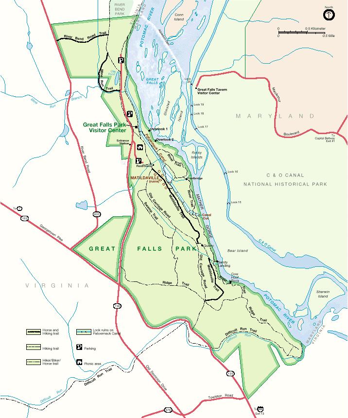
1 GSW spring field trip Geomorphic Evolution of Great Falls and Mather Gorge Led by E-an Zen, University of Maryland Saturday, May 17, a.m. to 12:30 p.m. Photo by Priestley Toulmin The focus of this field trip will be to study the geomorphic story behind the formation of Mather Gorge of the Potomac River, which terminates headward at Great Falls. Three objectives of the trip are: (1) to look at the field relations and evidence for the diachronous formation of seven identifiable straths in the gorge complex; (2) to account for these features in terms of likely processes of bedrock erosion and the relative efficacies of these processes; and (3) to discuss the ages of the features and to estimate the likelihood that these erosion processes are active today. The trip will be held at Great Falls National Park, on the Virginia side.
2
3 GSW spring field trip, 2003: GEOMORPHIC HISTORY OF THE POTOMAC RIVER GORGE COMPLEX Leader: E-an Zen, University of Maryland, College Park 9 a.m. to 12:30 p.m., May 17, 2003, Great Falls National Park Purpose During this trip, the group will examine the geomorphic story behind Mather Gorge of the Potomac River, which terminates headward at Great Falls. Our objectives are: (1) to look at the field relations and evidence for the diachronous formation of seven identifiable straths in the gorge complex; (2) to account for these features in terms of likely processes of bedrock erosion and the relative efficacies of these processes; and (3) to discuss the ages of formation of the features, and to consider whether these erosion processes are likely active today. Itinerary Stop 1. Orientation stop at an observation platform. Stop 2. Follow the Carriage Road to the flat-topped Glade Hill to see a fluviatile boulder deposit capping the hill: this is the oldest record of the Potomac River in the area. Stop 3. Sandy Landing; various features of fluvial bedrock erosion. Stop 4. Follow the River Trail back north, stopping at several features indicative of former straths and erosional features along the way, to the ruins of Matildaville where the next-to-the-oldest strath is recorded. Stop 5. Via the holding basin of the defunct Patowmack Canal and the trestle bridge to an exposure overlooking the gorge. Offset lamprophyre dikes on the gorge wall form the basis of an extant hypothesis explaining the straight alignment of the gorge. We will review the pros and cons of this idea. We will also briefly consider the P-T-t path of the metamorphic rocks and its implication on the tectonic role of the Mather Gorge Formation. Stop 6. Continue on the River Trail north to an outcrop featuring lateral potholes; their origin and known rates of excavation. Stop 7. A fossil waterfall and plungepool flood at this site will lead us to The story of the January Stop 8. The flood marker pole near the Visitor Center. The trip will conclude with a review of the competency of modern decadal floods in the excavation of the gorge.
4
5 2002 Denver Annual Meeting (October 27-30, 2002) Quaternary Geology/Geomorphology (Posters) I Vol 34, page 127 Paper No REUSSER, Lucas MAJOR, CLIMATE-CORRELATIVE INCISION OF THE POTOMAC RIVER GORGE AT GREAT FALLS ABOUT 30,000 YEARS AGO BIERMAN, Paul R., Geology, Univ of Vermont, Perkins Hall, Burlington, VT 05405, pbierman@zoo.uvm.edu, REUSSER, Lucas, Geology, Unviersity of Vermont, Perkins Hall, Burlington, VT 05405, lreusser@zoo.uvm.edu, PAVICH, Milan, US Geol Survey, Reston, VA 20192, ZEN, E-an, Department of Geology, Univ of Maryland, College Park, MD 20742, FINKEL, Robert, Center of Accelerator Mass Spectrometry, Lawerence Livermore National Lab, Livermore, CA 94550, LARSEN, Jennifer, Geology Department, Univ of Vermont, Burlington, VT 05405, and BUTLER, Eric M., Geology, Univ of Vermont, 001 Perkins, University of Vermont, Burlington, VT Large rivers along the mid-atlantic coast flow through spectacular bedrock gorges as they exit the Piedmont onto the Coastal Plain and their tidewater reaches. Was this incision driven by tectonic or climatic forcing? When did it occur? In order to infer the cause and understand the timing, spatial distribution, and rate of the bedrock incision in two such gorges, we collected >70 samples for 10-Be and 26-Al analysis from exposed, fluvially eroded outcrops of quartzbearing schist along strath terraces of the Potomac and Susquehanna Rivers at the Piedmont/Coastal Plain transition. Here we report primarily on the Potomac gorge. The first 18 samples, collected from Mather Gorge below Great Falls on the Potomac River, indicate that the most prominent strath terrace, a several kmlong bedrock feature 20 to 25 m above the current low water level, was abandoned rapidly as the Potomac River incised about 30 kya (SL, >60 deg, 10-Be PR=5.17 atoms/g). Nine samples, collected from water-polished rock surfaces down a cross-section from this terrace to just above the river, have decreasing nuclide activities consistent with a fluvial, bedrock incision rate of about 70 cm/ky and an effective 6 ky exposure age at water level. Four samples, collected from below the normal low-flow level during the 2000 drought, have activities equivalent to about 5 ky of exposure. Thus, to account for cosmicray dosing at and just below the waterís surface, we have subtracted 6 ky of exposure from older terrace surface ages. The incision of Mather Gorge began about 30 ky coincident with a major drop (50 m) in eustatic sea level, the result of glacial ice-volume increase. Incision is clearly coincident with cooling climate but we do not know if it was driven by base-level fall or by changes in discharge and sediment loading. However, the similarity of model exposure ages for samples collected from a kmlong transect parallel to the river and within 2 km of the present-day knick point at Great Falls, suggests that retreat of the knick point which formed the gorge must have been rapid, lasting only a few thousand years.
6
7
8

9 May 17, 2003, 2:15 pm Current Flow 81,900 cubic feet per second
1. Head east on Little River Turnpike/VA-236 E towards the Beltway. 0.8 mi
 Geology of the Billy Goat Trail, C&O Canal National Historical Park, Maryland Field Studies in Geology GOL 135 Northern Virginia Community College, Annandale C. Bentley Meet here at 9am The field trip
The Geology of Sebago Lake State Park
 Maine Geologic Facts and Localities September, 2002 43 55 17.46 N, 70 34 13.07 W Text by Robert Johnston, Department of Agriculture, Conservation & Forestry 1 Map by Robert Johnston Introduction Sebago
LATE PLEISTOCENE BEDROCK CHANNEL INCISION ALONG THE. U.S. ATLANTIC PASSIVE MARGIN MEASURED WITH 10 Be: HOLTWOOD GORGE, SUSQUEHANNA RIVER, PENNSYLVANIA
 LATE PLEISTOCENE BEDROCK CHANNEL INCISION ALONG THE U.S. ATLANTIC PASSIVE MARGIN MEASURED WITH 10 Be: HOLTWOOD GORGE, SUSQUEHANNA RIVER, PENNSYLVANIA A Thesis Presented by Lucas Jonathan Reusser to The
American Journal of Science
 [American Journal of Science, Vol. 306, February, 2006, P.69 102] American Journal of Science FEBRUARY 2006 AN EPISODE OF RAPID BEDROCK CHANNEL INCISION DURING THE LAST GLACIAL CYCLE, MEASURED WITH 10
mountain rivers fixed channel boundaries (bedrock banks and bed) high transport capacity low storage input output
 high transport capacity low storage input output") mountain rivers fixed channel boundaries (bedrock banks and bed) high transport capacity low storage input output strong interaction between streams & hillslopes Sediment Budgets for Mountain Rivers Little
mountain rivers fixed channel boundaries (bedrock banks and bed) high transport capacity low storage input output strong interaction between streams & hillslopes Sediment Budgets for Mountain Rivers Little
Ch 10 Deposition Practice Questions
 1. Base your answer to the following question on the data table below. Six identical cylinders, A through F, were filled with equal volumes of sorted spherical particles. The data table shows the particle
Amazing Ice: Glaciers and Ice Ages
 Amazing Ice: Glaciers and Ice Ages Updated by: Rick Oches, Professor of Geology & Environmental Sciences Bentley University Waltham, Massachusetts Based on slides prepared by: Ronald L. Parker, Senior
Determination of uplift rates of fluvial terraces across the Siwaliks Hills, Himalayas of central Nepal
 Determination of uplift rates of fluvial terraces across the Siwaliks Hills, Himalayas of central Nepal Martina Böhme Institute of Geology, University of Mining and Technology, Freiberg, Germany Abstract.
Pat Dryer Half Moon Lake: A True Oxbow Lake? Geography 364 April 1 st, 2007
 Pat Dryer Half Moon Lake: A True Oxbow Lake? Geography 364 April 1 st, 2007 Appendix Abstract 2 Introduction 3 Methods 3 Results 3 Discussion 5 Conclusion 11 1 Abstract Half Moon Lake appears to be an
Sedimentation Rate Change in the Winooski River Delta
 Sedimentation Rate Change in the Winooski River Delta Chris Ricker and Brian Connelly Abstract Historical air photographs, from 1937 show the Winooski River Delta extended much farther into Lake Champlain
COSMOGENIC 10 BE EROSION HISTORY OF THE BLUE RIDGE ESCARPMENT A LONG-LIVED FEATURE OF THE SOUTHERN APPALACHAINS
 COSMOGENIC 10 BE EROSION HISTORY OF THE BLUE RIDGE ESCARPMENT A LONG-LIVED FEATURE OF THE SOUTHERN APPALACHAINS A Thesis Progress Report Presented by Colleen L. Sullivan to The Faculty of the Geology Department
6. The Incision History of a Passive Margin River, the Potomac Near Great Falls
 6. The Incision History of a Passive Margin River, the Potomac Near Great Falls By Paul Bierman, 1 E-an Zen, 2 Milan Pavich, 3 and Luke Reusser 1 Introduction This field trip focuses on the emerging significance
A Thesis Proposal Presented. Lucas Jonathan Reusser. The Faculty of the Geology Department. The University of Vermont.
 USING COSMOGENIC NUCLIDES TO DETERMINE THE TIMING, SPATIAL PATTERN, AND RATE OF FLUVIAL INCISION WITHIN BEDROCK CHANNELS OF THE SUSQUEHANNA RIVER, PENNSYLVANIA A Thesis Proposal Presented by Lucas Jonathan
Glacial Geology of Moose Point State Park, ME
 Geologic Site of the Month May, 2013 Glacial Geology of Moose Point State Park, Maine 44 o 25 59.18"N, 68 o 56 37.11"W Text and photos by Woodrow B. Thompson, Department of Agriculture, Conservation &
Field Trip Number One. By: Pat Dryer. Geography 360
 Field Trip Number One By: Pat Dryer Geography 360 Table of Contents Introduction. Page 1 Stop One... Page 2 Stop Two... Page 4 Stop Three... Page 5 Stop Four... Page 7 Bibliography Page 8 Campus Map Source:
Module 10: Resources and Virginia Geology Topic 4 Content: Virginia Geology Notes
 Virginia is composed of a very diverse landscape that extends from the beaches and barrier islands all of the way to the highly elevated Appalachian Plateau. Geologists have discovered ancient shallow
The Bedrock Geology of Mount Battie, Camden, Maine
 Maine Geologic Facts and Localities July, 2001, Maine 44 13 15.40 N, 69 4 5.10 W Text by Henry N. Berry IV, Department of Agriculture, Conservation & Forestry 1 Photo by Henry N. Berry IV Introduction
Question #1: What are some ways that you think the climate may have changed in the area where you live over the past million years?
 Reading 5.2 Environmental Change Think about the area where you live. You may see changes in the landscape in that area over a year. Some of those changes are weather related. Others are due to how the
Name. 4. The diagram below shows a soil profile formed in an area of granite bedrock. Four different soil horizons, A, B, C, and D, are shown.
 Name 1. In the cross section of the hill shown below, which rock units are probably most resistant to weathering? 4. The diagram below shows a soil profile formed in an area of granite bedrock. Four different
Landscape evolution. An Anthropic landscape is the landscape modified by humans for their activities and life
 Landforms Landscape evolution A Natural landscape is the original landscape that exists before it is acted upon by human culture. An Anthropic landscape is the landscape modified by humans for their activities
Bull, William B., 1990, Stream-Terrace Genesis: implications for soil development, Geomorphology, V.3, p
 Luke Reusser Surface Processes Seminar Spring, 2002 Annotated Bibliography-Fluvial Terraces Bull, William B., 1990, Stream-Terrace Genesis: implications for soil development, Geomorphology, V.3, p.351-367.
GEOL 1121 Earth Processes and Environments
 GEOL 1121 Earth Processes and Environments Wondwosen Seyoum Department of Geology University of Georgia e-mail: seyoum@uga.edu G/G Bldg., Rm. No. 122 Seyoum, 2015 Chapter 6 Streams and Flooding Seyoum,
C) use of nuclear power D) number of volcanic eruptions
 use of nuclear power D) number of volcanic eruptions") 3121-1 - Page 1 Name: 1) The graph below shows the change in carbon dioxide concentration in parts per million (ppm) in Earth's atmosphere from 1960 to 1990. The most likely cause of the overall change
3121-1 - Page 1 Name: 1) The graph below shows the change in carbon dioxide concentration in parts per million (ppm) in Earth's atmosphere from 1960 to 1990. The most likely cause of the overall change
Glaciology (as opposed to Glacial Geology) Why important? What are glaciers? How do they work?
 Why important? What are glaciers? How do they work?") Glaciology (as opposed to Glacial Geology) Why important? What are glaciers? How do they work? Glaciers are important because of their role in creating glacial landscapes (erosional and depositional features).
Glaciology (as opposed to Glacial Geology) Why important? What are glaciers? How do they work? Glaciers are important because of their role in creating glacial landscapes (erosional and depositional features).
3/5/05 Dr. Stewart 1
 I. Physiography of Appalachian Mountains A. Introduction 1. These mountains extend from NE Canada to Georgia 2. They are the remains of a deeply eroded, ancient mountain chain once larger than the Himalayans
Maine Geologic Facts and Localities October, Lobster Lake, Maine. Text by Robert G. Marvinney. Maine Geological Survey
 Maine Geologic Facts and Localities October, 1998 Lobster Lake, Maine 45 o 51 7.91 N, 69 o 30 53.88 W Text by Robert G. Marvinney, Department of Agriculture, Conservation & Forestry 1 Map by Introduction
Term Knowledge Using and applying Grade Criteria Autumn 1 Assessment window October Natural hazards pose major risks to people and property.
 Assessment Schedule Year 9 2015/6 Term Knowledge Using and applying Grade Criteria Autumn 1 Assessment window October 2015 3.1.1.2 Tectonic Natural hazards pose major risks to people and property. Definition
depression above scarp scarp
 1 LAB 1: FIELD TRIP TO McKINLEYVILLE AND MOUTH OF THE MAD RIVER OBJECTIVES: a. to look at geomorphic and geologic evidence for large scale thrust-faulting of young sediments in the Humboldt Bay region
GEOL 02 Lab 9 Field Trip III Centerville Stratigraphic Section Name: Date:
 Name: Date: Team Name: Team Members: Our goal today is to describe the sedimentary lithostratigraphic section of exposed bedrock along the road near Centerville Beach, interpret the depositional environment,
Weathering, Erosion, Deposition, and Landscape Development
 Weathering, Erosion, Deposition, and Landscape Development I. Weathering - the breakdown of rocks into smaller particles, also called sediments, by natural processes. Weathering is further divided into
Avoiding Geohazards in the Mid-Atlantic Highlands by Using Natural Stream Principles
 Avoiding Geohazards in the Mid-Atlantic Highlands by Using Natural Stream Principles J. Steven Kite, WVU Neal Carte, WVDOT Will Harman, Michael Baker Corp. Donald D. Gray, WVU Photo: W. Gillespie North
Geohistory Review. Things you need to know:
 Geohistory Review Things you need to know: a) The earth and the solar system are 4.5 billion years old (4.5 X 10 9 ) b) Law of original horizontality: Sedimentary rock layers are always deposited as horizontal
A Geological Tour of Tumbledown Mountain, Maine
 Maine Geologic Facts and Localities April, 1998 A Geological Tour of Tumbledown Mountain, Maine 44 45 3.21 N, 70 32 50.24 W Text by Robert G. Marvinney, Department of Agriculture, Conservation & Forestry
Cattaraugus Creek: A Story of Flowing Water and the Geology of the Channel It Flows Through Presentation to West Valley Citizen Task Force 4/27/16
 Cattaraugus Creek: A Story of Flowing Water and the Geology of the Channel It Flows Through Presentation to West Valley Citizen Task Force 4/27/16 Raymond C. Vaughan, Ph.D. What happens if you drop a
Active Coastal Processes in the Lubec Embayment
 The Lubec Embayment Maine Geologic Facts and Localities August, 1998 Active Coastal Processes in the Lubec Embayment 44 49 50.51 N, 66 59 34.16 W Text by Joseph T. Kelley, Department of Agriculture, Conservation
Low rates of bedrock outcrop erosion in the central Appalachian Mountains inferred from in situ 10 Be
 DR2013023 Low rates of bedrock outcrop erosion in the central Appalachian Mountains inferred from in situ 10 Be Eric W. Portenga Department of Geology University of Vermont Burlington, VT 05405 Paul R.
Glaciers. (Shaping Earth s Surface, Part 6) Science 330 Summer 2005
 Science 330 Summer 2005") Glaciers (Shaping Earth s Surface, Part 6) Science 330 Summer 2005 1 Glaciers Glaciers are parts of two basic cycles Hydrologic cycle Rock cycle Glacier a thick mass of ice that originates on land from
Glaciers (Shaping Earth s Surface, Part 6) Science 330 Summer 2005 1 Glaciers Glaciers are parts of two basic cycles Hydrologic cycle Rock cycle Glacier a thick mass of ice that originates on land from
Section 11.1 pp Where Mountains Form
 Section 11.1 pp. 236 237 Where Mountains Form Chapter 11 Set a Purpose: TE, p. 236 Reading Study Guide, p. 36 Discussion: TE, p. 236 Differentiating ion Reading Support: TE, p. 236 Visual Teaching Interpret
Section 7. Reading the Geologic History of Your Community. What Do You See? Think About It. Investigate. Learning Outcomes
 Chapter 3 Minerals, Rocks, and Structures Section 7 Reading the Geologic History of Your Community What Do You See? Learning Outcomes In this section, you will Goals Text Learning Outcomes In this section,
What are the different ways rocks can be weathered?
 Romano - 223 What are the different ways rocks can be weathered? Weathering - the breakdown of rocks and minerals at the Earth s surface 1. 2. PHYSICAL WEATHERING Rock is broken into smaller pieces with
The Coast: Beaches and Shoreline Processes
 1 2 3 4 5 6 7 8 9 The Coast: es and Shoreline Processes Trujillo & Thurman, Chapter 10 Oceanography 101 Chapter Objectives Recognize the various landforms characteristic of beaches and coastal regions.
 Page 1 of 9 Name: Base your answer to the question on the diagram below. The arrows show the direction in which sediment is being transported along the shoreline. A barrier beach has formed, creating a
Glaciers Earth 9th Edition Chapter 18 Glaciers: summary in haiku form Key Concepts Glaciers Glaciers Glaciers Glaciers
 1 2 3 4 5 6 7 8 9 10 11 12 13 14 Earth 9 th Edition Chapter 18 : summary in haiku form Ten thousand years thence big glaciers began to melt - called "global warming." Key Concepts and types of glaciers.
Which landscape best represents the shape of the valleys occupied by glaciers? A) B) C) D)
 B) C) D)") 1. Glaciers often form parallel scratches and grooves in bedrock because glaciers A) deposit sediment in unsorted piles B) deposit rounded sand in V-shaped valleys C) continually melt and refreeze D) drag
1. Glaciers often form parallel scratches and grooves in bedrock because glaciers A) deposit sediment in unsorted piles B) deposit rounded sand in V-shaped valleys C) continually melt and refreeze D) drag
Answers: Internal Processes and Structures (Isostasy)
") Answers: Internal Processes and Structures (Isostasy) 1. Analyse the adjustment of the crust to changes in loads associated with volcanism, mountain building, erosion, and glaciation by using the concept
Answers: Internal Processes and Structures (Isostasy) 1. Analyse the adjustment of the crust to changes in loads associated with volcanism, mountain building, erosion, and glaciation by using the concept
The Coast: Beaches and Shoreline Processes Trujillo & Thurman, Chapter 10
 The Coast: es and Shoreline Processes Trujillo & Thurman, Chapter 10 Oceanography 101 Chapter Objectives Recognize the various landforms characteristic of beaches and coastal regions. Identify seasonal
Geol 117 Lecture 18 Beaches & Coastlines. I. Types of Coastlines A. Definition:
 I. Types of Coastlines A. Definition: 1. Shore = narrow zone where ocean meets land (e.g. beach) 2. Coast is a broad area where both ocean and land processes act a. Includes onshore marshes, dunes, sea
MISSISSIPPI RIVER DELTA OVERVIEW
 MISSISSIPPI RIVER DELTA OVERVIEW Science and Engineering Special Team Conference Louisiana State University October 9, 2012 Introduction Basics of the Mississippi Delta Natural and Human-Induced Land Loss
Veronica Sosa-Gonzalez Defense Presentation
 Veronica Sosa-Gonzalez Defense Presentation Background Introduction Methods Results and Interpretations Conclusion Final remarks Photo credits: K. Nichols Determine long-term erosion rates in Panama, using
Name Roy G Biv Page 1
 Name Roy G Biv Base your answers to questions 1 through 3 on the diagram below. The arrows show the direction in which sediment is being transported along the shoreline. A barrier beach has formed, creating
Earth Science Chapter 6 Section 2 Review
 Name: Class: Date: Earth Science Chapter 6 Section Review Multiple Choice Identify the choice that best completes the statement or answers the question. 1. Most streams carry the largest part of their
Holocene Lower Mississippi River Avulsions: Autogenic Versus Allogenic Forcing*
 Holocene Lower Mississippi River Avulsions: Autogenic Versus Allogenic Forcing* Eric Prokocki 1,2 Search and Discovery Article #50330 (2010) Posted October 14, 2010 *Adapted from oral presentation at AAPG
Running Water Earth - Chapter 16 Stan Hatfield Southwestern Illinois College
 Running Water Earth - Chapter 16 Stan Hatfield Southwestern Illinois College Hydrologic Cycle The hydrologic cycle is a summary of the circulation of Earth s water supply. Processes involved in the hydrologic
Biostratigraphic and Lithostratigraphic Correlation of Sedimentary Strata in the Atlantic Coastal Plain
 Biostratigraphic and Lithostratigraphic Correlation of Sedimentary Strata in the Atlantic Coastal Plain Introduction to the Atlantic Coastal Plain (Please read this page prior to doing the lab) The Atlantic
Chapter 5: Glaciers and Deserts
 I. Glaciers and Glaciation Chapter 5: Glaciers and Deserts A. A thick mass of ice that forms over land from the compaction and recrystallization of snow and shows evidence of past or present flow B. Types
Study on the Fluvial Geomorphological Meanings of Valley Plain in the River and Estimation of the Extreme River Discharge
 12th International Conference on Hydroscience & Engineering Study on the Fluvial Geomorphological Meanings of Valley Plain in the River and Estimation of the Extreme River Discharge Masaki Wakui, Shoji
The Science of Sea Level Rise and the Impact of the Gulf Stream
 Old Dominion University ODU Digital Commons July 29, 2016: The Latest in Sea Level Rise Science Hampton Roads Sea Level Rise/Flooding Adaptation Forum 7-29-2016 The Science of Sea Level Rise and the Impact
Lecture 10 Glaciers and glaciation
 Lecture 10 Glaciers and glaciation Outline Importance of ice to people! Basics of glaciers formation, classification, mechanisms of movement Glacial landscapes erosion and deposition by glaciers and the
ENVI.2030L Geologic Time
 Name ENVI.2030L Geologic Time I. Introduction There are two types of geologic time, relative and absolute. In the case of relative time geologic events are arranged in their order of occurrence. No attempt
Unit 7.2 W.E.D. & Topography Test
 Name: Score: Unit 7.2 W.E.D. & Topography Test 1. 2. 3. 4. 5. 6. 7. 8. 9. 10. 11. 12. 13. 14. 15. 16. 17. 18. 19. 20. 21. 22. 23. 24. 25. 1. The formation of mountains is due mainly to while the destruction
Name: Period: Date: ID: A. Circle the choice that best completes the statement or answers the question and write the letter on the blank.
 Name: Period: _ Date: _ ID: A Unit 7 Practice Circle the choice that best completes the statement or answers the question and write the letter on the blank. 1. What term describes the movement of rock
Spring break reading. Glacial formation. Surface processes: Glaciers and deserts. The Control of Nature
 suggested Spring break reading The Control of Nature by John McPhee Surface processes: Glaciers and deserts describes our efforts to control three natural hazards: 1. The Mississippi Floods 2. The Heimaey
RIVERS, GROUNDWATER, AND GLACIERS
 RIVERS, GROUNDWATER, AND GLACIERS Delta A fan-shaped deposit that forms when a river flows into a quiet or large body of water, such as a lake, an ocean, or an inland sea. Alluvial Fan A sloping triangle
Which map shows the stream drainage pattern that most likely formed on the surface of this volcano? A) B)
 B)") 1. When snow cover on the land melts, the water will most likely become surface runoff if the land surface is A) frozen B) porous C) grass covered D) unconsolidated gravel Base your answers to questions
1. When snow cover on the land melts, the water will most likely become surface runoff if the land surface is A) frozen B) porous C) grass covered D) unconsolidated gravel Base your answers to questions
Stream Geomorphology. Leslie A. Morrissey UVM July 25, 2012
 Stream Geomorphology Leslie A. Morrissey UVM July 25, 2012 What Functions do Healthy Streams Provide? Flood mitigation Water supply Water quality Sediment storage and transport Habitat Recreation Transportation
PR206 NARRATIVE Updated 16 June 2015
 PR206 NARRATIVE Updated 16 June 2015 Cross section PR206 was established in 1977 in a fairly straight reach of Powder River about a kilometer downriver of the Highway 212 bridge at Broadus. The section
Moosehead Lake and the Tale of Two Rivers
 Maine Geologic Facts and Localities June, 2005 45 o 53 5.09 N, 69 o 42 14.54 W Text by Kelley, A.R.; Kelley, J.T.; Belknap, D.F.; and Gontz, A.M. Department of Earth Sciences, University of Maine, Orono,
The Ovens, Bar Harbor, Maine
 Maine Geologic Facts and Localities July, 2003 The Ovens, Bar Harbor, Maine 44 26 15.65 N, 68 15 51.80 W Text by Henry Berry, Department of Agriculture, Conservation & Forestry 1 Postcard courtesy of Wally
Basin-scale analysis of long-term sediment-generation rates derived from 10 Be in river sediment:
 Basin-scale analysis of long-term sediment-generation rates derived from 10 Be in river sediment: The Susquehanna River basin and beyond Joanna M. Reuter M.S. Proposal April 30, 2003 Paul Bierman, advisor
Page 1. Name:
 Name: 1) Which property would best distinguish sediment deposited by a river from sediment deposited by a glacier? thickness of sediment layers age of fossils found in the sediment mineral composition
Beach Pebbles Tell a Story
 Maine Geologic Facts and Localities September, 2000 Text by Joseph T. Kelley, Department of Agriculture, Conservation & Forestry 1 Introduction The smooth, sandy beaches of southern Maine are popular with
PALEOGEOGRAPHY of NYS. Definitions GEOLOGIC PROCESSES. Faulting. Folding 9/6/2012. TOPOGRAPHIC RELIEF MAP of NYS GRADATIONAL TECTONIC
 TOPOGRAPHIC RELIEF MAP of NYS PALEOGEOGRAPHY of NYS Prof. Anthony Grande AFG 2012 Definitions GEOLOGIC PROCESSES Geography: study of people living on the surface of the earth. Geology: the scientific study
The Geology of the Marginal Way, Ogunquit, Maine
 Maine Geologic Facts and Localities February, 2002 The Geology of the Marginal Way, Ogunquit, Maine 43 14 23.88 N, 70 35 18.36 W Text by Arthur M. Hussey II, Bowdoin College and Robert G. Marvinney,, Department
Geomorphology Geology 450/750 Spring Fluvial Processes Project Analysis of Redwood Creek Field Data Due Wednesday, May 26
 Geomorphology Geology 450/750 Spring 2004 Fluvial Processes Project Analysis of Redwood Creek Field Data Due Wednesday, May 26 This exercise is intended to give you experience using field data you collected
Paradoxes of Fluvial Evolution in Young Orogenic Systems
 Journal of Indian Geomorphology Volume 5, 2017 ISSN 2320-0731 Indian Institute of Geomorphologists (IGI) Paradoxes of Fluvial Evolution in Young Orogenic Systems Leszek Starkel Department of Geoenvironmental
The subject paper is being submitted for approval for publication in the annual volume entitled Geological Survey Research.
 Water Resources Division 345 Middlefield Road Menlo Park, California January 12, 1965 Memorandum To: Mr. Frank E. Clark, Chief, General Hydrology Branch Thru: Area Hydrologist PCA From: Valmore C. LaMarche
Page 1. Name:
 Name: Questions 1 through 3 refer to the following: The diagrams below represent two rock outcrops found several miles apart in New York State. Individual rock layers are lettered, and fossils and rock
Lecture Outline Lecture Outline Monday April 9-16, 2018 Questions? Announcements:
 Lecture Outline Lecture Outline Monday April 9-16, 2018 Questions? Announcements: Geology 101 Night Video: The Day After Tomorrow Hollywood disaster movie about the onset of a glacial period When: Monday
Geology (Mellow) Hike, Santa Lucia Memorial Park February 16, I. Overview of Santa Lucia Range geology and tectonic history
 Hike, Santa Lucia Memorial Park February 16, I. Overview of Santa Lucia Range geology and tectonic history") Geology (Mellow) Hike, Santa Lucia Memorial Park February 16, 2015 I. Overview of Santa Lucia Range geology and tectonic history A. Basement Rocks 1. Salinian Block Rocks Sierra Nevada Type, continental
Geology (Mellow) Hike, Santa Lucia Memorial Park February 16, 2015 I. Overview of Santa Lucia Range geology and tectonic history A. Basement Rocks 1. Salinian Block Rocks Sierra Nevada Type, continental
Weathering, Erosion, and Deposition Guided Notes
 1. Weathering, Erosion, and Deposition 2. Outline Section 1: Weathering Section 2: Erosion Section 3: Deposition Section 4: Case Study Weathering, Erosion, and Deposition Guided Notes 3. Section 1: Weathering
Goals of Today s Lecture. Types of landscapes
 Goals of Today s Lecture 1. Breifly discuss mass continuity as applied to the landscape. 2. Establish the mechanisms that drive U (uplift rate) 3. Examine the linkages between the uplift of mountains,
Setting the Stage 8/28/09 1. Review. Landscape history of WY. Climate, geology and vegetation patterns in Wyoming
 Setting the Stage Climate, geology and vegetation patterns in Wyoming 8/28/09 1 Review Vegetation ecology has its roots in phytogeography: Observation and description of PATTERNS of plant species distributions
Fluvial Systems Lab Environmental Geology Lab Dr. Johnson
 Fluvial Systems Lab Environmental Geology Lab Dr. Johnson *Introductory sections of this lab were adapted from Pidwirny, M. (2006). "Streamflow and Fluvial Processes". Fundamentals of Physical Geography,
How does erosion happen?
 How does erosion happen? By National Geographic, adapted by Newsela staff on 10.03.17 Word Count 682 Level 830L These rock formations, in Bryce Canyon National Park, Utah, are called hoodoos. Although
Developed in Consultation with Florida Educators
 Developed in Consultation with Florida Educators Table of Contents Next Generation Sunshine State Standards Correlation Chart... 7 Benchmarks Chapter 1 The Practice of Science...................... 11
Today you will be able to: Utilize the SEVEN rules of rock age identification to describe the geologic age of this rock sequence!
 Mr. Sandomenico Welcome!!!! Today we will begin a new unit! The Earth s History!!!!! Today you will be able to: Utilize the SEVEN rules of rock age identification to describe the geologic age of this rock
Geologic Trips San Francisco and the Bay Area
 Excerpt from Geologic Trips San Francisco and the Bay Area by Ted Konigsmark ISBN 0-9661316-4-9 GeoPress All rights reserved. No part of this book may be reproduced without written permission in writing,
CAUSES FOR CHANGE IN STREAM-CHANNEL MORPHOLOGY
 CAUSES FOR CHANGE IN STREAM-CHANNEL MORPHOLOGY Chad A. Whaley, Department of Earth Sciences, University of South Alabama, MobileAL, 36688. E-MAIL: caw408@jaguar1.usouthal.edu The ultimate goal of this
Name Test Date Hour. forms that lived only during certain periods. abundant and widespread geographically. changes to the surface of Earth.
 Name Test Date Hour Earth Processes#3 - Notebook Earth s History LEARNING TARGETS I can explain the lack of evidence about the Precambrian Time. I can describe possible causes for the mass extinction in
The Building of the NYC Region
 The Building of the NYC Region Definitions Fall Line marks the area where an upland region (continental bedrock) and a coastal plain meet Piedmont the plateau region of the eastern United States which
The Marine Environment
 The Marine Environment SECTION 16.1 Shoreline Features In your textbook, read about erosional landforms, beaches, estuaries, longshore currents, and rip currents. For each statement below, write true or
STUDY GUIDE FOR CONTENT MASTERY. Surface Water Movement
 Surface Water SECTION 9.1 Surface Water Movement In your textbook, read about surface water and the way in which it moves sediment. Complete each statement. 1. An excessive amount of water flowing downslope
City of Fort Collins: Geology Staff Training, June 2012
 1 City of Fort Collins: Geology Staff Training, June 2012 Levels of Analysis Descriptive (What do you see, feel, hear, etc..) This rock is made of round grains of quartz. Interpretive-- (The detective
1. In the block diagram shown here, which is the oldest rock unit?
 Pre/Post GCI Name (print) 1. In the block diagram shown here, which is the oldest rock unit? 2. Referring to the same diagram as the previous question, which of the labeled rock units is the youngest?
Stop 1: Marmot Dam Stop 1: Marmot Dam
 Stop 1: Marmot Dam Stop 1: Marmot Dam Following the removal of Marmot Dam in 2007, the fate of the reservoir sediments has been monitored through a series of surveys and sediment transport measurements.
HW #2 Landscape Travel from A to B 12,
 HW #2 Landscape 2016 Section: Name: ate: 1. ase your answer(s) to the following question(s) on the map below, which represents two bridges that cross the Green River. Letters,, and represent locations
Chapter 3 Erosion and Deposition. The Big Question:
 Chapter 3 Erosion and Deposition The Big Question: 1 Design a way to represent and describe the 4 types of mass movement. You may use pictures, diagrams, list, web, chart, etc 2 Chapter 3: Erosion and
EROSION AND DEPOSITION
 CHAPTER 8 EROSION AND DEPOSITION SECTION 8 1 Changing Earth s Surface (pages 252-255) This section explains how sediment is carried away and deposited elsewhere to wear down and build up Earth s surface.
Diagnostic Geomorphic Methods for Understanding Future Behavior of Lake Superior Streams What Have We Learned in Two Decades?
 Diagnostic Geomorphic Methods for Understanding Future Behavior of Lake Superior Streams What Have We Learned in Two Decades? Faith Fitzpatrick USGS WI Water Science Center, Middleton, WI fafitzpa@usgs.gov
Why Geomorphology for Fish Passage
 Channel Morphology - Stream Crossing Interactions An Overview Michael Love Michael Love & Associates mlove@h2odesigns.com (707) 476-8938 Why Geomorphology for Fish Passage 1. Understand the Scale of the