R. R, S. DISCOVERY CRUISES 27 AND 28 REPORT
|
|
|
- Arnold O’Connor’
- 6 years ago
- Views:
Transcription

1 K N99/D/27-28 NATIONAL INSTITUTE OF OCEANOGRAPHY WORMLEY, GODALMING, SURREY R. R, S. DISCOVERY CRUISES 27 AND 28 REPORT JUNE JULY 1969 GEOLOGICAL OBSERVATIONS N.I.O. CRUISE REPORT No. 27 and 28 (Issued June 1970)
2 National Institute of Oceanogrq;>hy Wormley, Godalming, Surrey. R. R. S. Discovery Cruises 27 and 28 Report June - July 1969 Geological Observations inailunal^eanographicl IIBRARY I N. I. O. Cruise Report No. 27 and 28 (Issued June 1970)
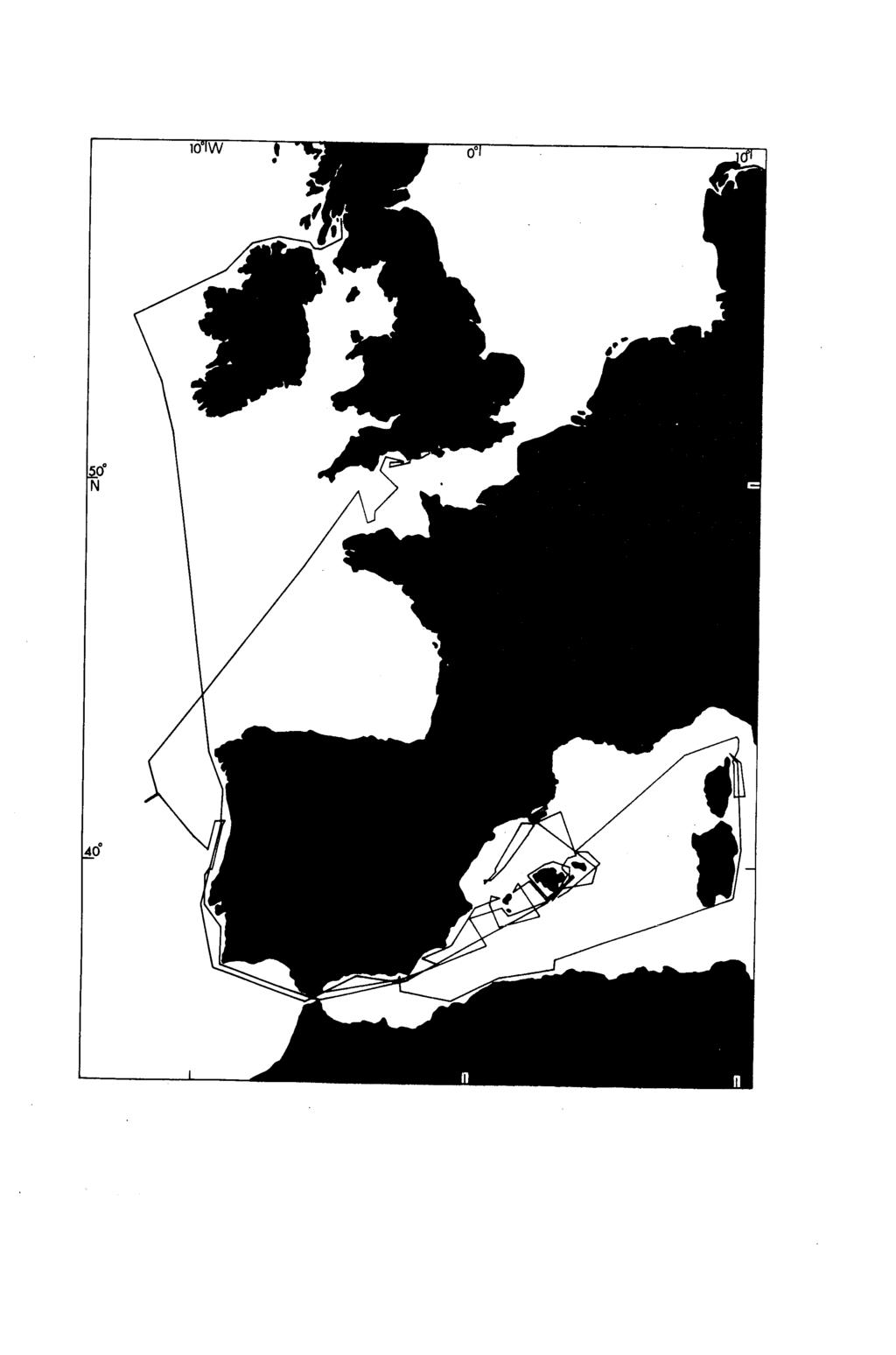
3 Contents Page Scientific Staff Dates Equipment used Projects 1. Sea trials and use of Gloria. 2. Sea trials and use of air gun reflection profiling equipment 2 (Dr. B. S. McCartney). 3. Evolution of the Balearic Island Ridge Evolution of the continental margin of eastern Spain Reflection profiles west of Iberia Short range side-scan asdic survey Collection of zooplankton for chemical analysis ( R.J. Morris). 3 Station List 4 Track Chart 5
4 R. R. S. "Discovery" RQJrt of Cruises 27 and 28 9th June - 24th July Scientific Staff Before 30th June After 3 rd July After 17th July Dr. Dr. B. J. Barrow R. H. Belderson S. V. Bicknell D. G. Bishop R. Bonner R. Dobson R. H. Edge H. M. C. Fielding T. M. Jones N. H. Kenyon V. A. L. Lawford A. F. Madgwick B. S. McCartney (Leader Air Gun Team) R. J. Morris R, Peters D. G. Roberts J. S. M. Rusby (Leader GLORIA Team) M. L. Somers N. D. Smith A. H, B. Stride Principal Scientist A. R. Stubbs K.D. S.K. P. G. Walton Willis Woods Dates Monday 9th June 30th June Thursday 3 rd July 17th July Ship departed L. Fyne for Mediterranean. Ship reached Gibraltar. Ship departed Gibraltar for Mediterranean. Ship called at Gibraltar. 24th July Ship reached Southampton. Equipment used Gloria (Geological long range inclined asdic), air guns, short range sidescan asdic, P. D. R., Neuston, one metre N113, one metre N113, Oxfam nets. Projects 1. Sea trials and use of Gloria The first trials of this equipment in the open sea were made in the
5 - 2 ~ western part of the Mediterranean in the lee of the Balearic Isles in order to be reasonably certain of good conditions for its launching, recovery and use. This sea also provided a wide variety of sea floor types which could be examined within a relatively small area, so giving a first indication of the potentialities of the method as soon as possible. Deep lying basin floor was found to be as uniform as expected and contrasted markedly with the continental slopes dissected by submarine canyons and deformed by slumps Besides this more or less predictable information certain new features were found. The latter include rocky benches trending along the continental slope, faults and bands seemingly of variable roughness trending down the slope. A detailed account of the handling and operation of the operation of the equipment will be prepared by Dr. J. S. M. Rusby for the whole period of operation during the summer of Sea trials and use of air gun reflection profiling equipment (Dr. B. S. McCartney) Instrument tests included the following work. Measurements were made of the depth at which hydrophones towed for various rigs and ships' speeds; air gun pressur waveforms were photographed from the C. R. O. as functions of the number, depth, volume and pressure of the guns; some noise level recordings on tape were made to examine the influence of flow noise as a function of hydrophone spacings. The air gun equipment was operated successfully for a total running time of 140 hrs., with the ship generally at, to provide Mufax records covering over 800 nautical miles of track. It took some time to make the new electrically triggered air guns work reliably enough for five or six of them to be used together in the towed array. The guns generally worked at 800 p. s. i. for four or five hours, before air leaks became unacceptable and the array needed to be serviced or guns replaced. A shipboard testing of the guns was carried out in a 40 gallon drum of water on the poop. The older, 28 ins^, free-running ' Ewing' type gun was put to use and operated satisfactorily, when the air-gun array was unserviceable and could generally be relied upon for 10 hours after which replacement of the P. T. F. E. piston seal was necessary. Results with this gun at 1,500 p. s. i. were only slightly inferior to the triggered guns, of total capacity 50 cu. ins., firing at 800 p. s. i. The new compressor overheated at first, due to poor ventilation in the space aft of the Upper Scientific Hold. This was overcome by inserting a continuous flow, sea-water heat exchanger kindly lent by the ship's engineers to cool the recirculating fresh water. A blower fan at the air inlet duct also helped. The new 200 ft. long towed hydrophones were satisfactory acoustically, but are still mechanically weak especially at towing speeds above. One of these hydrophones was halved in length and used for the majority of the cruise. The new receiver console and modified Mufax recorder were generally quite reliable. The 4 sec, sweep speed on the recorder was useful especially in the Mediterranean where the depth range throughout a run was considerable. Two-way travel times within the sea floor varied from about 0.5 to 2 sees, depending upon location and sea-state. Recordings on 24 magnetic tapes of reflection profiling runs were made for further analysis in the laboratory.
6 3, Evolution of the Balearic Islands Ridge Work carried out between and around the Balearic Isles was largely designed to aid interpretation of the Gloria records by providing information about the structure, composition and origin of the sea floor. Extensive sidescan asdic coverage of the shelf was complemented on the surrounding slopes by 12 air gun profiles showing the underlying structure and profiles of its surface obtained by P. D. R. and by the side-scan asdic used as a narrow beam echo-sounder. 4. Evolution of the eastern continental margin of Spain Exploratory work was carried out on the Mediterranean continental slope of Spain in order to provide a link between the new work around the Balearic Isles and published geological studies of the Atlantic side of Iberia. 5. Reflection profiles west of Iberia The quality of the profiles of the continental borderland west of Iberia obtained by means of air gun reflection equipment was not as good as profiles of the Mediterranean floor because of the rough seas encountered. 6. Short range side-scan asdic survey Every opportunity was taken to use the short range side-scan asdic on the continental shelf and upper part of the continental slope, both as a reconnaisance tool and for filling gaps in existing coverage. Valuable data was obtained while on passage past Ireland, in the Celtic Sea, around Iberia, the Balearic Isles, off North Africa and, while storm-bound, to the east of Corsica. The new information relates to bed-transport paths, geological structure and erosional features such as submarine canyons. Use of the equipment as an echo-sounder was of particular value because of its far narrower sound beam than the conventional echo sounder, which allowed the relief to be seen without the usual distortion in the form of parabolic echoes. 7. Collection of zooplankton for chemical analysis (R.J. Morris) Zooplankton were collected at 14 surface stations in the Western Mediterranean and at 1 station off the west coast of Portugal. Three types of surface net were used - a neuston net and a one metre N113 net with TMT8 mesh, both towed at 5- and a one metre N113 Oxfam net towed at 1^-2 knots. All ^ecimens were stores under nitrogen at -20 C. The animals primarily of interest were the small Crustaceans, the Copepods and Euphausiids which occur at the sea surface at ni^t. Also caught were squid and pelagic fish such as Myctophids, which undergo large vertical daily migrations. The Lipids of all these animals will be analysed for their constituent Fatty Acids. In addition, samples of jellyfish and surface living fish such as flying fish and garfish were retained for later analysis of their pesticide content by the Government Chemist.
7 4 - Date Discovery Station Number Station List Latitude Longitude Net Towing Speed 4/7/ ' 00*27' ' 00 25' 5/7/ ' 01 24' 6/7/ ' 03 15' 8/7/ ' 02 19' Oxfam li knots ' 02 13' 9/7/69 11/7/ ' 41 18' 01 28' 03 30' 12/7/ ' 03 24' Oxfam 2 knots 13/7/ ' 01 43' ' 01 52' 14/7/ ' 00 56' 15/7/ ' 00 33' 5^ knots 16/7/ ' 03 37' 17/7/ ' 07 33' Oxfam 1^ knots 5^ knots
8

9 t'narf, %?,»S1N% M ii.i,*'i # ' oi4 A S - #:'T; gg #? RSW ahg.^5 w wm
NATIONAL INSTITUTE OF OCEANOGRAPHY WORMLEY. GODALMING. SURREY R. R. S. DISCOVERY SEPTEMBER - OCTOBER 1967 GEOLOGICAL INVESTIGATIONS
 NATIONAL INSTITUTE OF OCEANOGRAPHY WORMLEY. GODALMING. SURREY R. R. S. DISCOVERY CRUISE 19 REPORT SEPTEMBER - OCTOBER 1967 GEOLOGICAL INVESTIGATIONS N. I.O. CRUISE REPORT No. 19 (Issued May 1969) NATIONAL
SITE SURVEY FOR SITE 410, AN EXAMPLE OF THE USE OF LONG-RANGE SIDE-SCAN SONAR (GLORIA)
") 10. SITE SURVEY FOR SITE 410, AN EXAMPLE OF THE USE OF LONG-RANGE SIDE-SCAN SONAR (GLORIA) R. C. Searle and A. S. Laughton, Institute of Oceanographic Sciences, Wormley, GU8 5UB, UK and B. D. Loncarevic,
10. SITE SURVEY FOR SITE 410, AN EXAMPLE OF THE USE OF LONG-RANGE SIDE-SCAN SONAR (GLORIA) R. C. Searle and A. S. Laughton, Institute of Oceanographic Sciences, Wormley, GU8 5UB, UK and B. D. Loncarevic,
Chapter Overview. Bathymetry. Measuring Bathymetry. Measuring Bathymetry
 CHAPTER 3 Marine Provinces Chapter Overview The study of bathymetry determines ocean depths and ocean floor topography. Echo sounding and satellites are efficient bathymetric tools. Most ocean floor features
Bathymetry Measures the vertical distance from the ocean surface to mountains, valleys, plains, and other sea floor features
 1 2 3 4 5 6 7 8 9 10 11 CHAPTER 3 Marine Provinces Chapter Overview The study of bathymetry determines ocean depths and ocean floor topography. Echo sounding and satellites are efficient bathymetric tools.
R.C. Searle P.M. Hunter Institute of Oceanographic Sciences Wormley, Godalming, Surrey, GU8 SUB
 THE USE OF GLORIA LONG-RANGE SIDESCAN SONAR FOR DEEP-OCEAN MAPPING R.C. Searle P.M. Hunter Institute of Oceanographic Sciences Wormley, Godalming, Surrey, GU8 SUB ABSTRACT The Institute of Oceanographic
Iceberg Plough Marks in the Vicinity of the Norwegian Trough
 Iceberg Plough Marks in the Vicinity of the Norwegian Trough ROBERT H. BELDERSON & JOHN B. WILSON Belderson, R. H. & Wilson, J. B.: Iceberg plough marks in the vicinity of the Norwegian Trough. Norsk Geologisk
Map shows 3 main features of ocean floor
 Map shows 3 main features of ocean floor 2017 Pearson Education, Inc. Chapter 3 Marine Provinces 2017 Pearson Education, Inc. 1 Chapter 3 Overview The study of bathymetry determines ocean depths and ocean
Earth in 2-D, 3-D & 4-D
 Earth in 2-D, 3-D & 4-D We will consider the scientific tools and techniques used to map surface features, reconstruct the layered structure of Earth, and interpret Earth history, including the origin
Lecture Marine Provinces
 Lecture Marine Provinces Measuring bathymetry Ocean depths and topography of ocean floor Sounding Rope/wire with heavy weight Known as lead lining Echo sounding Reflection of sound signals 1925 German
The Ocean Floor Earth Science, 13e Chapter 13
 The Ocean Floor Earth Science, 13e Chapter 13 Stanley C. Hatfield Southwestern Illinois College The vast world ocean Earth is often referred to as the blue planet Seventy-one percent of Earth s surface
GG710 Remote Sensing in Submarine Environments Sidescan Sonar
 GG710 Remote Sensing in Submarine Environments Sidescan Sonar Harold Edgerton, a professor of electrical engineering at the Massachusetts Institute of Technology, developed sidescan sonar technology for
Ocean Basins, Bathymetry and Sea Levels
 Ocean Basins, Bathymetry and Sea Levels Chapter 4 Please read chapter 5: sediments for next class and start chapter 6 on seawater for Thursday Basic concepts in Chapter 4 Bathymetry the measurement of
Oceanography, An Invitation to Marine Science 9e Tom Garrison. Ocean Basins Cengage Learning. All Rights Reserved.
 Oceanography, An Invitation to Marine Science 9e Tom Garrison 4 Ocean Basins Key Concepts Tectonic forces shape the seabed The ocean floor is divided into continental margins and deep ocean basins The
OCEANOGRAPHY MEASURING THE DEPTHS OF THE OCEANS
 Water 2 page 1 OCEANOGRAPHY Name If all the water was drained from the ocean basins, what kind of surface would be revealed? It would not be the quiet, subdued topography as was once thought, but a surface
Warm Up 1: Ocean Floors LT I can explain the concept of Pangea. I can describe how Ocean Ridges form and give examples of them.
 Warm Up 1: Ocean Floors 4-18-17 LT I can explain the concept of Pangea. I can describe how Ocean Ridges form and give examples of them. Q1. How do we get a diversity of birds? Q2. How did the breeds of
Chapter 02 The Sea Floor
 Chapter 02 The Sea Floor Multiple Choice Questions 1. One of the following is not one of the world's major ocean basins: A. Atlantic Ocean B. Arctic Ocean C. Indian Ocean D. Antarctic Ocean E. Pacific
Introduction to Acoustic Remote Sensing and Seafloor Mapping (AE4-E13) May 19, 2010
 May 19, 2010") Introduction to Acoustic Remote Sensing and Seafloor Mapping (AE4-E13) May 19, 2010 1 Delft Vermelding Institute onderdeel of Earth organisatie Observation and Space Systems Why Acoustic Remote Sensing?
Introduction to Acoustic Remote Sensing and Seafloor Mapping (AE4-E13) May 19, 2010 1 Delft Vermelding Institute onderdeel of Earth organisatie Observation and Space Systems Why Acoustic Remote Sensing?
Foundations of Earth Science, 6e Lutgens, Tarbuck, & Tasa
 Foundations of Earth Science, 6e Lutgens, Tarbuck, & Tasa Oceans: The Last Frontier Foundations, 6e - Chapter 9 Stan Hatfield Southwestern Illinois College The vast world ocean Earth is often referred
APPLICATION FOR THE CONSENT TO CONDUCT MARINE SCIENTIFIC RESEARCH IN AREAS UNDER NATIONAL JURISDICTION OF THE UNITED KINGDOM
 APPLICATION FOR THE CONSENT TO CONDUCT MARINE SCIENTIFIC RESEARCH IN AREAS UNDER NATIONAL JURISDICTION OF THE UNITED KINGDOM 1. General information Date: 27 th January 2011 1.1 Cruise name and/or number:
Oceanography. Oceanography is the study of the deep sea and shallow coastal oceans.
 Oceanography Oceanography is the study of the deep sea and shallow coastal oceans. Studying the Ocean Floor To determine the shape and composition of the ocean floor, scientists use techniques such as
Cruise Report R/V Oceania, AREX 2007
 Powstańców Warszawy 55, PL - 81-712 Sopot, P.O. Box 68 March 15, 2008 Cruise Report R/V Oceania, AREX 2007 Ship: R/V Oceania Cruise: AREX 2007 Dates: 19.06.2007 05.08.2007 Port Calls: Gdansk (Poland) Longyearbyen
Directed Reading. Section: The Water Planet. surface is called the a. Earth s ocean. b. Pacific Ocean. c. salt-water ocean. d. global ocean.
 Skills Worksheet Directed Reading Section: The Water Planet 1. The body of salt water covering nearly three-quarters of the Earth s surface is called the a. Earth s ocean. b. Pacific Ocean. c. salt-water
Earth s Continents and Seafloors. GEOL100 Physical Geology Ray Rector - Instructor
 Earth s Continents and Seafloors GEOL100 Physical Geology Ray Rector - Instructor OCEAN BASINS and CONTINENTAL PLATFORMS Key Concepts I. Earth s rocky surface covered by of two types of crust Dense, thin,
Lab # - Ocean Bottom Topography. Background Information:
 Name Lab Grade /10 Date Period Lab # - Ocean Bottom Topography Background Information: Ocean depth varies markedly from one location to another. Over large areas water depth is less than 200m (650 ft);
Seafloor Morphology. Techniques of Investigation. Bathymetry and Sediment Studies
 Seafloor Morphology I f we select a grid for the surface of the earth (i.e. 5 km 2 ) and assign it an average elevation in relation to sea level, we can construct a graph of elevation versus area of the
Meteor-Cruise M 75 / 2 Short Cruise Report Chief scientist: Dr. Jürgen Pätzold Universität Bremen Bremen / Germany
 Meteor-Cruise M 75 / 2 Short Cruise Report Chief scientist: Dr. Jürgen Pätzold Universität Bremen Bremen / Germany Dar es Salaam Dar es Salaam Febr. 06 th Febr. 24 th, 2008 1 SHORT CRUISE REPORT RV METEOR
Lecture Outlines PowerPoint. Chapter 13 Earth Science 11e Tarbuck/Lutgens
 Lecture Outlines PowerPoint Chapter 13 Earth Science 11e Tarbuck/Lutgens 2006 Pearson Prentice Hall This work is protected by United States copyright laws and is provided solely for the use of instructors
12/11/2013& egm502 seafloor mapping
 egm502 seafloor mapping lecture 13 multi-beam echo-sounders The majority of the current charts of the ocean floors have been produced from single beam echo-sounder data. Even though these data have been
APPENDIX B PHYSICAL BASELINE STUDY: NORTHEAST BAFFIN BAY 1
 APPENDIX B PHYSICAL BASELINE STUDY: NORTHEAST BAFFIN BAY 1 1 By David B. Fissel, Mar Martínez de Saavedra Álvarez, and Randy C. Kerr, ASL Environmental Sciences Inc. (Feb. 2012) West Greenland Seismic
I. Earth s Layers a. Crust: Earth s outside layer. Made of mostly rock. i. Continental: er; made of mostly granite, forms the continents and shallow
 I. Earth s Layers a. Crust: Earth s outside layer. Made of mostly rock. i. Continental: er; made of mostly granite, forms the continents and shallow sea beds, floats! ii. Oceanic: er; dense rock such as
Unit 6: The Sea Floor
 Unit 6: The Sea Floor Turn to Page 62 in Introduction to the World s Oceans Study the bathymetric chart What features do you see? How do the Atlantic and Pacific Oceans differ? What do you think accounts
CRUISE REPORT. Spring 2014 SEAMAP Plankton Survey Cruise RV Blazing Seven
 CRUISE REPORT Spring 2014 SEAMAP Plankton Survey Cruise 1401 RV Blazing Seven Louisiana Department of Wildlife and Fisheries Fisheries Research Laboratory 195 Ludwig Annex Grand Isle, LA 70358 Chief Scientist
The Ocean Floor Chapter 14. Essentials of Geology, 8e. Stan Hatfield and Ken Pinzke Southwestern Illinois College
 The Ocean Floor Chapter 14 Essentials of Geology, 8e Stan Hatfield and Ken Pinzke Southwestern Illinois College The vast world ocean Earth is often referred to as the water planet 71% of Earth s surface
Oceanography II Notes
 Oceanography II Notes Tides The rise and fall in sea level is called a tide. Caused by a giant wave and the gravitational pull of the moon and sun on the ocean One low-tide/high-tide cycle takes about
June 13-July 8, Astoria-Astoria
 MGL1211: Cascadia Basin Ridge to Trench June 13-July 8, Astoria-Astoria Motivation 1. How does the JdF plate evolve from ridge to trench and is there significant hydration of the crust and upper mantle
Almost of Earth is covered by water. On a map, the continents appear as huge islands surrounded by a vast global ocean.
 Earth s Oceans & Ocean Floor Date: Feelin Blue What are Earth s five main oceans? Almost of Earth is covered by water. On a map, the continents appear as huge islands surrounded by a vast global ocean.
Marine Science and Oceanography
 Marine Science and Oceanography Marine geology- study of the ocean floor Physical oceanography- study of waves, currents, and tides Marine biology study of nature and distribution of marine organisms Chemical
Name Class Date. The ocean floor has varied and distinct surfaces much like those found on land.
 6 Explore the Seafloor BigIdeas The ocean floor has varied and distinct surfaces much like those found on land. Satellites orbiting Earth, as well as sonar technology, are used to map the seafloor. The
Coordinates : A - of midpoint or summit : Lat., Long. } to. Description (kind of feature) : seachannel
 : seachannel") INTERNATIONAL HYDROGRAPHIC ORGANIZATION INTERGOVERNMENTAL OCEANOGRAPHIC COMMISSION (of UNESCO) IHO/IOC Form No. 1 UNDERSEA FEATURE NAME PROPOSAL (See NOTE overleaf) Ocean or Sea Japan Sea Name proposed
INTERNATIONAL HYDROGRAPHIC ORGANIZATION INTERGOVERNMENTAL OCEANOGRAPHIC COMMISSION (of UNESCO) IHO/IOC Form No. 1 UNDERSEA FEATURE NAME PROPOSAL (See NOTE overleaf) Ocean or Sea Japan Sea Name proposed
Chapter Two. Figure 02_02. Geography of the Ocean Basins. The Sea Floor
 Chapter Two The Sea Floor Geography of the Ocean Basins Figure 02_02 The world ocean is the predominant feature on the Earth in total area. In the Northern Hemisphere, 61% of the total area is ocean. In
The surface of the ocean floor is as varied as the land. The five major oceans, from largest to smallest, are
 11.1 Ocean Basins The surface of the ocean floor is as varied as the land. The five major oceans, from largest to smallest, are w the Pacific w the Atlantic w the Indian w the Southern w the Arctic The
Earth / Environmental Science. Ch. 14 THE OCEAN FLOOR
 Earth / Environmental Science Ch. 14 THE OCEAN FLOOR The Blue Planet Nearly 70% of the Earth s surface is covered by the global ocean It was not until the 1800s that the ocean became an important focus
Exploring Geography. Chapter 1
 Exploring Geography Chapter 1 The Study of Geography Geography is the study of where people, places, and things are located and how they relate to each other. Greek meaning writing about or describing
GEOL- 270: Issues in Oceanography Developed by Jessica Kleiss, Lewis & Clark College
 GEOL- 270: Issues in Oceanography Developed by Jessica Kleiss, Lewis & Clark College Lab 02: Ocean floor bathymetry. Material for students to bring: A calculator A ruler Pens and pencils Objectives: Interpret
LATITUDES AND LONGITUDES
 NAME SCHOOL INDEX NUMBER DATE LATITUDES AND LONGITUDES KCSE 1989 2012 Form 4 Mathematics Answer all the questions 1. 1989 Q18 P1 A globe representing the earth has a radius 0.5m. Points A(10 0 W), B (0
Chapter 4. Seafloor & Ocean Basins. Lecture #5 Week #4. A.K. Morris, Ph.D. We are a species of seafarers. Oceanography Lecture #5
 Chapter 4 We are a species of seafarers Seafloor & Ocean Basins Oceanography Lecture #5 1 2 We have become very good at reading the sea surface Despite all that we know historically about the ocean 3 4
The Sea Floor. Chapter 2
 The Sea Floor Chapter 2 Geography of the Ocean Basins World ocean is the predominant feature on the Earth in total area Northern Hemisphere = 61% of the total area is ocean. Southern Hemisphere = about
Plate Tectonic Vocabulary Chapter 10 Pages
 Name: Period: Plate Tectonic Vocabulary Chapter 10 Pages 239-260 Vocabulary Word What is this? What are some examples? What does it look like? (draw a picture or diagram) Continental drift Mid-ocean ridge
W. R. Bowering and D. Power Northwest Atlantic Fisheries Centre, P. O. Box 5667 St. John s, Newfoundland, Canada A1C 5X1. Abstract
 NAFO Sci. Coun. Studies, 22: 51 61 Spatial Distribution of Greenland Halibut (Reinhardtius hippoglossoides (Walbaum)) in the Labrador-Eastern Newfoundland Area of the Canadian Northwest Atlantic W. R.
Report on the 2005 Dogger Bank cruise with R. V. Senckenberg
 Report on the 2005 Dogger Bank cruise with R. V. Senckenberg 2. 10. 8. 2005 MICHAEL TÜRKAY Forschungsinstitut Senckenberg Frankfurt a. M. Contents: 1. Aims and setting 2. Narrative and methods 3. Methods
Last Time. GY 305: Geophysics. Seismology (Marine Surveys) Seismology. Seismology. Other Seismic Techniques UNIVERSITY OF SOUTH ALABAMA
 Seismology. Seismology. Other Seismic Techniques UNIVERSITY OF SOUTH ALABAMA") UNIVERSITY OF SOUTH ALABAMA Last Time GY 305: Geophysics Lecture 12: Introduction to (resolution versus penetration) Techniques (marine versus terrestrial) (Marine Surveys) http://www.glossary.oilfield.slb.com/displayimage.cfm?id=236
UNIVERSITY OF SOUTH ALABAMA Last Time GY 305: Geophysics Lecture 12: Introduction to (resolution versus penetration) Techniques (marine versus terrestrial) (Marine Surveys) http://www.glossary.oilfield.slb.com/displayimage.cfm?id=236
Basin Acoustic Seamount Scattering Experiment (BASSEX) Data Analysis and Modeling
 Data Analysis and Modeling") Basin Acoustic Seamount Scattering Experiment (BASSEX) Data Analysis and Modeling Kevin D. Heaney Ocean Acoustical Services and Instrumentation Services, Inc. 5 Militia Dr. Lexington MA, 02421 phone: (703)
Basin Acoustic Seamount Scattering Experiment (BASSEX) Data Analysis and Modeling Kevin D. Heaney Ocean Acoustical Services and Instrumentation Services, Inc. 5 Militia Dr. Lexington MA, 02421 phone: (703)
NEW SEAFLOOR INSTALLATIONS REQUIRE ULTRA-HIGH RESOLUTION SURVEYS
 NEW SEAFLOOR INSTALLATIONS REQUIRE ULTRA-HIGH RESOLUTION SURVEYS Donald Hussong (Fugro Seafloor Surveys, Inc.) dhussong@fugro.com Fugro Seafloor Surveys, Inc., 1100 Dexter Avenue North (Suite 100), Seattle,
REPORT ON SEA LEVEL MEASUREMENT FOR GHANA
 20TH SEPTEMBER 2006 REPORT ON SEA LEVEL MEASUREMENT FOR GHANA Emmanuel K. Nkebi 1 1 Survey Department of Ghana, P. O. Box CT903, Accra Tel: 233 21 777 334 Fax : 233 21 765687 E-mail: survey@ghana.com E-mail:eknkebi@yahoo.com
FINMARINET: Inventories and Planning for the Marine Natura 2000 Network in Finland. A.2 Geological inventories of the seafloor Final Report
 LIFE07 NAT/FIN/000151 FINMARINET: Inventories and Planning for the Marine Natura 2000 Network in Finland A.2 Geological inventories of the seafloor Final Report Geological Survey of Finland, GTK 1. Introduction
3. UNDERWAY GEOPHYSICS 1
 Sawyer, D.S., Whitmarsh, R.B., Klaus, A., et al., 1994 Proceedings of the Ocean Drilling Program, Initial Reports, Vol. 149 3. UNDERWAY GEOPHYSICS 1 Shipboard Scientific Party 2 EQUIPMENT AND METHODS Navigation
Chapter 9 Lecture Outline. Oceans: The Last Frontier
 Chapter 9 Lecture Outline Oceans: The Last Frontier The Vast World Ocean Earth is referred to as the blue planet 71% of Earth s surface is oceans and marginal seas Continents and islands comprise the remaining
Earth Science 11 Learning Guide Unit Complete the following paragraph about the ocean and ocean water with the following words:
 Earth Science 11 Learning Guide Unit 8 Name: 8-1 Ocean Properties 1. Complete the following paragraph about the ocean and ocean water with the following words: thousand chloride 70% salinity water sodium
Small area of the ocean that is partially surrounded by land. The Ocean Basins. Three Major Oceans. Three Major Oceans. What is a SEA?
 The Ocean Basins How Deep is the Ocean? 1 2 Three Major Oceans Three Major Oceans Pacific Atlantic the shallowest ocean (3.3km average depth) Indian second shallowest ocean (3.8km average depth) Pacific
Non-Technical Summary
 Non-Technical Summary Proposed Project TGS-NOPEC Geophysical Company ASA (TGS) proposes to undertake a two dimensional (2D) seismic survey and seabed sampling in the western Greenland Sea off North East
IODP drilling and core storage facilities
 4 IODP drilling and core storage facilities Neville Exon As the knowledge obtainable from ocean drilling is various and extensive, its end-users are similarly various and extensive. Scientific ocean drilling
GEOSCIENCE 105 THE DYNAMIC EARTH FIRST ONE-HOUR EXAMINATION. Tuesday, October 20, 1998 NAME STUDENT #
 GEOSCIENCE 105 THE DYNAMIC EARTH FIRST ONE-HOUR EXAMINATION Tuesday, October 20, 1998 NAME STUDENT # Instructions: 1. Answer all questions legibly. 2. Put your name and student number on this front page.
ARE YOU READY TO THINK? Look at the first slide THINK PAIR SHARE!
 ARE YOU READY TO THINK? Look at the first slide THINK PAIR SHARE! WHAT PROMINENT FEATURE CAN YOU IDENTIFY IN THIS PICTURE? What do you think the different colors represent? Who might find such a picture
Activity #3 - Bathymetric Mapping
 Activity #3 - Bathymetric Mapping Concepts # 1, 2 #1 The floor of the ocean is composed of hills, plains, ridges, trenches, and seamounts. #2 Oceanographers have developed methods for mapping the ocean
Origin and Evolution of the Ocean Floor
 Origin and Evolution of the Ocean Floor Outline Mapping the Ocean Floor Continental Margins Origin of Oceanic Lithosphere Structure of Ocean Crust Mapping the ocean floor Depth originally measured by lowering
8.9A - describe the historical development of evidence that supports plate tectonic theory
 8.9A - describe the historical development of evidence that supports plate tectonic theory Theory of Plate Tectonics the theory that pieces of Earth s lithosphere are in constant motion on the asthenosphere.
Oceanography is the scientific study of oceans Oceans make up over 70% of the Earth s surface
 Oceanography Oceanography is the scientific study of oceans Oceans make up over 70% of the Earth s surface An ocean must be large and have features which set it apart from other oceans (currents, water
Baltic Sea Research Institute
 Baltic Sea Research Institute Warnemuende (IOW) Cruise Report No. 44/96/ 04 R/V "A.v.Humboldt" MESODYN Cruise 01 to 12 March 1996 Stolpe Furrow / Baltic Sea This report is based on preliminary data and
60% water. Big Bang: 14,000 millions years ago The Earth originated about 4,500 millions years ago its orbit allows water to exist in a liquid state!
 Ch2. The Sea Floor #1 Why geology of the oceans? Marine habitats are directly shaped by geological processes The form of the coastlines The depth of the water Type of bottom (muddy, sandy, rocky) #2 Geological
Shape of the seafloor. Shape of the seafloor. Shape of the seafloor. Shape of the seafloor. Shape of the seafloor. Shape of the seafloor
 Multibeam echo sounders - Research vessel Scripps Institution of Oceanography R/V Roger Revelle depth Source: Scripps Institution of Oceanography http://woodshole.er.usgs.gov/project-pages/caribbean/movie1.html
High resolution geoid from altimetry & bathymetry: requirements for a future mission
 High resolution geoid from altimetry & bathymetry: requirements for a future mission The GRAL team: J-Y Royer 1,2, M-F Lalancette 3, G Louis 1,2, M Maia 1,2, D Rouxel 3 & L Géli 4 Project funded by 1 2
MARINE GEOLOGY & GEOGRAPHY
 MARINE GEOLOGY & GEOGRAPHY Bathymetry BATHYMETRY BATHYMETRY THE UNDERWATER EQUIVALENT TO TOPOGRAPHY THE STUDY OF WATER DEPTH A BATHYMETRIC MAP SHOWS FLOOR RELIEF OR TERRAIN AS CONTOUR LINES Bathymetry
Kuroshio Transport East of Taiwan and the Effect of Mesoscale Eddies
 DISTRIBUTION STATEMENT A. Approved for public release; distribution is unlimited. Kuroshio Transport East of Taiwan and the Effect of Mesoscale Eddies Magdalena Andres Wood Hole Oceanographic Institution
The route towards a new GEBCO grid
 The route towards a new GEBCO grid Pauline Weatherall, GEBCO Digital Atlas Manager British Oceanographic Data Centre (BODC) GEBCO TSCOM/SCRUM meeting, Monaco, October 2012 The route towards a new GEBCO
I. CORE-DISCING AND OTHER DRILLING EFFECTS IN DSDP LEG 42A MEDITERRANEAN SEDIMENT CORES
 I. CORE-DISCING AND OTHER DRILLING EFFECTS IN DSDP LEG 42A MEDITERRANEAN SEDIMENT CORES Robert B. Kidd, Institute of Oceanographic Sciences, Wormley, Surrey, United Kingdom INTRODUCTION Since deep-sea
The United States & Canada. A Regional Study of Anglo America
 A Regional Study of Anglo America Landform Regions of the United States & Canada world leaders in agricultural and industrial production because of... VAST LANDS stretch from the Atlantic Ocean on the
3. UNDERWAY GEOPHYSICS 1
 Mayer, L., Pisias, N., Janecek, T., et al., 1992 Proceedings of the Ocean Drilling Program, Initial Reports, Vol. 138 3. UNDERWAY GEOPHYSICS 1 Stephen F. Bloomer 2 and Shipboard Scientific Party 3 INTRODUCTION
A Planned Course Statement for. Oceanography. Course # 410 Grade(s) 9, 10, 11, 12. Length of Period (mins.) 40 Total Clock Hours: 60
 9, 10, 11, 12. Length of Period (mins.) 40 Total Clock Hours: 60") East Penn School District Secondary Curriculum A Planned Course Statement for Oceanography Course # 410 Grade(s) 9, 10, 11, 12 Department: Science ength of Period (mins.) 40 Total Clock Hours: 60 Periods
East Penn School District Secondary Curriculum A Planned Course Statement for Oceanography Course # 410 Grade(s) 9, 10, 11, 12 Department: Science ength of Period (mins.) 40 Total Clock Hours: 60 Periods
APPENDIX 1. A MARINE GEOPHYSICAL SURVEY (SITE 211 DSDP) IN THE WHARTON BASIN, INDIAN OCEAN 1
 IN THE WHARTON BASIN, INDIAN OCEAN 1") APPENDIX 1. A MARINE GEOPHYSICAL SURVEY (SITE 211 DSDP) IN THE WHARTON BASIN, INDIAN OCEAN 1 Bhoopal R. Naini, Lamont-Doherty Geological Observatory of Columbia University, Palisades, New York ABSTRACT
APPENDIX 1. A MARINE GEOPHYSICAL SURVEY (SITE 211 DSDP) IN THE WHARTON BASIN, INDIAN OCEAN 1 Bhoopal R. Naini, Lamont-Doherty Geological Observatory of Columbia University, Palisades, New York ABSTRACT
OCEANOGRAPHY II NOTES
 TIDES OCEANOGRAPHY II NOTES MRS. BURKEY EARTH SPACE SCIENCE CY CREEK HS THE RISE AND FALL IN SEA LEVEL IS CALLED A TIDE. CAUSED BY A GIANT WAVE. AVERAGE LOW-TIDE/HIGH-TIDE CYCLE TAKES ABOUT 12 HRS AND
Cruise Report R.V. Oceania, AREX2004
 Powstaców Warszawy, PL - 81-71 Sopot, P.O. Box 68 November 16. 4 Cruise Report R.V. Oceania, AREX4 Ship: Cruise: R.V. Oceania Arex4 Dates: 8.6.4 19.7.4 Port Calls: Sopot (Poland) Longyearbyen (Spitsbergen)
discussion of North America s physical features, including its landforms and bodies of
 Chapter 7 Natural Environments of North America Chapter 7 focuses on the natural environments of North America. The chapter opens with a discussion of North America s physical features, including its landforms
Submarine Sand Dunes on the Continental Slope in the South China Sea and Their Impact on Internal Wave Transformation and Acoustic Propagation
 DISTRIBUTION STATEMENT A. Approved for public release; distribution is unlimited. Submarine Sand Dunes on the Continental Slope in the South China Sea and Their Impact on Internal Wave Transformation and
Underwater Acoustics OCEN 201
 Underwater Acoustics OCEN 01 TYPES OF UNDERWATER ACOUSTIC SYSTEMS Active Sonar Systems Active echo ranging sonar is used by ships to locate submarine targets. Depth sounders send short pulses downward
MR. JOHNSON S. Geography OHIO COUNTY MIDDLE SCHOOL
 MR. JOHNSON S Geography OHIO COUNTY MIDDLE SCHOOL CHAPTER 1 Geography The science of geography is likely the oldest of all sciences. Geography is the answer to the question that the earliest humans asked,
Strategies for and results from the investigation of migrating bedforms in the German Bight
 Strategies for and results from the investigation of migrating bedforms in the German Bight Thomas F. WEVER 1, Ingo H. STENDER 2 1 Forschungsanstalt der Bundeswehr für Wasserschall und Geophysik (FWG),
2001 State of the Ocean: Chemical and Biological Oceanographic Conditions in the Newfoundland Region
 Stock Status Report G2-2 (2) 1 State of the Ocean: Chemical and Biological Oceanographic Conditions in the Background The Altantic Zone Monitoring Program (AZMP) was implemented in 1998 with the aim of
General Oceanography Geology 105 Expedition 8 Plate Boundaries Beneath the Sea Complete by Thursday at 11:00 PM
 General Oceanography Geology 105 Expedition 8 Plate Boundaries Beneath the Sea Complete by Thursday at 11:00 PM Name Expedition Objectives Learn about the types of plate boundaries and their key characteristics
Gear data report from Atlantic plankton cruises for the R/V Pathfinder, March March 1962
 College of William and Mary W&M ScholarWorks Reports 1962 Gear data report from Atlantic plankton cruises for the R/V Pathfinder, March 1961 - March 1962 Woodrow L. Wilson Virginia Institute of Marine
Acoustic seafloor mapping systems. September 14, 2010
 Acoustic seafloor mapping systems September 14, 010 1 Delft Vermelding Institute onderdeel of Earth organisatie Observation and Space Systems Acoustic seafloor mapping techniques Single-beam echosounder
Last Time. Submarine Canyons and Fans. Turbidites. MAS 603: Geological Oceanography. Lecture 16: Greenhouse vs. Icehouse Earths
 UNIVERSITY OF SOUTH ALABAMA Last Time MAS 603: Geological Oceanography Lecture 16: Greenhouse vs. Icehouse Earths Submarine Fans Definition and morphology Transport mechanisms (density currents) Submarine
EXECUTIVE SUMMARY A SUBMISSION OF DATA AND INFORMATION ON THE OUTER LIMITS OF THE CONTINENTAL SHELF OF THE REPUBLIC OF NIGERIA PURSUANT TO
 EXECUTIVE SUMMARY A SUBMISSION OF DATA AND INFORMATION ON THE OUTER LIMITS OF THE CONTINENTAL SHELF OF THE REPUBLIC OF NIGERIA PURSUANT TO PART VI OF AND ANNEX II TO THE UNITED NATIONS CONVENTION ON THE
The giant Gas planets of the outer solar system. Rocky inner planets. Silicates with Iron/Nickel cores. Hydrogen, Helium, methane, water, ammonia
 SUN Hydrogen (74%), some helium (24%) Rocky inner planets Silicates with Iron/Nickel cores The giant Gas planets of the outer solar system Hydrogen, Helium, methane, water, ammonia Where did the water
Preliminary Information Indicative of the Outer Limits of the Continental Shelf Beyond 200 Nautical Miles of the People s Republic of China
 (Translation) Preliminary Information Indicative of the Outer Limits of the Continental Shelf Beyond 200 Nautical Miles of the People s Republic of China 1. The People s Republic of China ratified the
A Factor of 2-4 Improvement in Marine Gravity and Predicted Bathymetry from CryoSat, Jason-1, and Envisat Radar Altimetry: Arctic and Coastal Regions
 DISTRIBUTION STATEMENT A. Approved for public release; distribution is unlimited. A Factor of 2-4 Improvement in Marine Gravity and Predicted Bathymetry from CryoSat, Jason-1, and Envisat Radar Altimetry:
Chapter 2. The Planet Oceanus
 Chapter 2 The Planet Oceanus Composition of the Earth The Earth consists of a series of concentric layers or spheres which differ in chemistry and physical properties. There are two different ways to describe
Your web browser (Safari 7) is out of date. For more security, comfort and the best experience on this site: Update your browser Ignore
 is out of date. For more security, comfort and the best experience on this site: Update your browser Ignore") Your web browser (Safari 7) is out of date. For more security, comfort and the best experience on this site: Update your browser Ignore ISTHMU S tombolo For the complete encyclopedic entry with media resources,
Your web browser (Safari 7) is out of date. For more security, comfort and the best experience on this site: Update your browser Ignore ISTHMU S tombolo For the complete encyclopedic entry with media resources,
Plate Tectonics CHAPTER 17
 Plate Tectonics CHAPTER 17 Layers of the Earth A. Crust- solid, 5-70 km thick Moho Two Types of Crust: Oceanic- ocean floor, more dense then because of more iron Continental-dry land (mostly silicates
Section 21.1 pp What is Climate?
 Section 21.1 pp. 466 468 What is Climate? Set a Purpose: TE, p. 466 Reading Study Guide, p. 73 More about How Climate Controls Interact TE, p. 466 Differentiating ion Reading Support: TE, p. 466 Critical
Week: 4 5 Dates: 9/8 9/12 Unit: Plate Tectonics
 clementaged.weebly.com Name: ODD Period: Week: 4 5 Dates: 9/8 9/12 Unit: Plate Tectonics Monday Tuesday Wednesday Thursday Friday 7 No School 8 E 9 O *Vocabulary *Frayer Vocab *Continental Drift Notes