Chapter 4. Seafloor & Ocean Basins. Lecture #5 Week #4. A.K. Morris, Ph.D. We are a species of seafarers. Oceanography Lecture #5
|
|
|
- Asher Norris
- 5 years ago
- Views:
Transcription


1 Chapter 4 We are a species of seafarers Seafloor & Ocean Basins Oceanography Lecture #5 1 2 We have become very good at reading the sea surface Despite all that we know historically about the ocean 3 4 Fig. 4.1 Our knowledge of the seafloor pales in comparison. No shortage of ways to sample the ocean bottom these days 5 Seegurke J. Gutt 6


 Father of modern physical oceanography First detailed")

 Aside: commissioned")
2 Proto bathysphere Made out of leather and metal Gaspard Schott s Curiosa sive Mirabilia Artis 1664 Historic seafloor Mapping Heaving the lead Line is clearly marked 2 fathoms from the lead 2 strips of leather. 3 fa 3 strips of leather. 5 fa a piece of white cloth. 7 fa a piece of red cloth. 10 fa a piece of leather with a hole in it. 13 fa a piece of blue cloth. 15 fa same as for 5 fathoms. 17 fa same as for 7 fathoms. 20 fa small line with 2 knots. 25 fa small line with 1 knot. 30 fa small line with 3 knots. 35 fa small line with 1 knot. 40 fa small line with 4 knots. 7 UGH! don t t forget your clear markers 8 Historic Seafloor Mapping The deeper you went, the less accurate your measurement was Wind Matthew Fontaine Maury ( ) Father of modern physical oceanography First detailed Atlantic seafloor map (1854) Actually detected the Mid Atlantic ridge, but didn t t know what to make of it R.V. Minnow R.V. Minnow Current 9 10 Matthew Fontaine Maury ( ) Aside: commissioned by the American whaling industry to map whale takes (pink represents sperm whales) Historic Scientific Cruises US Exploring Expedition ( ) H.M.S. Challenger Expedition ( ) 11 12


 1876) British")


3 US Exploring Expedition ( ) 1842) American endeavor 6 ships Lt. Charles Wilkes Attempted to map the entire Pacific Smithsonian collection started with this expedition Discovered and named Antarctica! H.M.S. Challenger Expedition ( ) 1876) British endeavor Professor Sir Charles Wyville Thomson Sounding the Bottom Only 300 deep water measurements Thomson found the bottom was as varied as on land Birth of the echo sounder USN invention Uses sound speed in seawater 1922 Birth of the echo sounder Changing the frequency and intensity = new applications! LARGE SCALE: Seismic Reflection Profiling Multi channel seismic systems MEDIUM SCALE: Multi beam echo sounders (side scan scan sonar is most common) FINE SCALE: Chirp Profilers NOAA 17 18


 Actual multi channel")


")


4 Choosing frequency & intensity The car stereo example Seismic Reflection Profiling (large scale) Sound waves fired by an air gun from the ship Sound echoes off different sub-layers Returns to detector at different times Multi channel seismic systems (large scale) Actual multi channel seismic data Same concept using sound waves fired by an air gun Uses many different frequencies, so Much better resolution 21 USGS Gyre Cruise, Bryant Canyon, Louisiana Gulf Coast [Nealon, Dillon, & Twichell, 2000]. USGS Report Echo Sounders (medium scale) Side-scan sonar is very popular today Fan-shaped pulses Works well over relatively flat areas Pluses: Accurate, portable Minuses Difficult over variable bottoms and rough seas Wyse's Ferry Bridge on the bottom of Lake Murray, South Carolina, 160 ft depth. Side scan sonar modern applications Wreck Hunting Frank A. Palmer Both ships collided on Dec 17, 1902 and sank off MA Re-discovered in 2002 Both are still loaded with coal Louise B. Crary 23 24


 25 26")


5 NOAA s s favorite tool these days. Convenience (a rarity in oceanographic sampling) Chirp Profilers (fine scale samplers) Chirp scientific application Sandy Baldwin Chirp applied uses Fig. 4.3 Tacoma, WA 29 30


 33 34")

6 Satellite Altimetry seafloor mapping from space??? USS Alligator video Fig. 4.4 Smith Sandwell Map (based on gravity measurements by satellites and ship board instruments) Sound in the Sea Passive acoustics Active acoustics Passive acoustics Atlantic common dolphin sound: 35 36


")


7 Active acoustics Most things in the sea resonate Must find their unique frequency Then you can see them Speed of Sound in the Sea approximately 4,921 ft per second Temperature Salinity Pressure SOFAR channel (sound fixing and ranging) Morris, Macauley and Hamner, in press Speed of Sound in the Sea SOFAR channel (sound fixing and ranging) 3 main zones of concern BOTTOM LINE: sound waves get trapped in the SOFAR channel Low Frequency Active Sonar (LFAS) formerly Acoustic Thermometry of Ocean Climate (ATOC) US Navy plans to cover 80% of the ocean with this quiet submarine detection system. VERY low frequencies Low Frequency Active Sonar (LFAS) formerly Acoustic Thermometry of Ocean Climate (ATOC) Low Frequency Active Sonar (LFAS) formerly Acoustic Thermometry of Ocean Climate (ATOC) Growing evidence that it is dangerous/deadly to marine life X OVERTURNED! 41 42


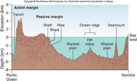
8 Bimodal Crust and Isostasy Bimodal 2 states of earth crust Ocean basins Continents Isostasy steady buoyant state Archimedes principle an objects buoyancy determined by weight of stuff it displaces In this case, balance between weight of crust and weight of fluid mantle it displaces Earth s hypsographic curve Add more weight, it will sink more Think: glaciers, sedimentation, etc Seafloor Provinces Continental Margins Deep Ocean Basins Oceanic Ridges Hydrothermal Vents Continental Margins Passive versus Active 47 48


9 Fig Active margin: seismically activity, border of plates Pacific-type margin Passive margin: no activity, trailing edge of plate Atlantic-type margin Fig Lesson in Geo anatomy Fig Deep Ocean Basins Abyssal plains mostly featureless expanse Abyssal hills jagged basement covered by many millennia worth of sediment Trenches 53 54


10 Fig Oceanic Ridges Hydrothermal vents Hydrothermal vents 59 60
Marine Science and Oceanography
 Marine Science and Oceanography Marine geology- study of the ocean floor Physical oceanography- study of waves, currents, and tides Marine biology study of nature and distribution of marine organisms Chemical
Chapter Overview. Bathymetry. Measuring Bathymetry. Measuring Bathymetry
 CHAPTER 3 Marine Provinces Chapter Overview The study of bathymetry determines ocean depths and ocean floor topography. Echo sounding and satellites are efficient bathymetric tools. Most ocean floor features
Oceanography, An Invitation to Marine Science 9e Tom Garrison. Ocean Basins Cengage Learning. All Rights Reserved.
 Oceanography, An Invitation to Marine Science 9e Tom Garrison 4 Ocean Basins Key Concepts Tectonic forces shape the seabed The ocean floor is divided into continental margins and deep ocean basins The
Bathymetry Measures the vertical distance from the ocean surface to mountains, valleys, plains, and other sea floor features
 1 2 3 4 5 6 7 8 9 10 11 CHAPTER 3 Marine Provinces Chapter Overview The study of bathymetry determines ocean depths and ocean floor topography. Echo sounding and satellites are efficient bathymetric tools.
Map shows 3 main features of ocean floor
 Map shows 3 main features of ocean floor 2017 Pearson Education, Inc. Chapter 3 Marine Provinces 2017 Pearson Education, Inc. 1 Chapter 3 Overview The study of bathymetry determines ocean depths and ocean
Lecture Marine Provinces
 Lecture Marine Provinces Measuring bathymetry Ocean depths and topography of ocean floor Sounding Rope/wire with heavy weight Known as lead lining Echo sounding Reflection of sound signals 1925 German
Ocean Basins, Bathymetry and Sea Levels
 Ocean Basins, Bathymetry and Sea Levels Chapter 4 Please read chapter 5: sediments for next class and start chapter 6 on seawater for Thursday Basic concepts in Chapter 4 Bathymetry the measurement of
Unit 6: The Sea Floor
 Unit 6: The Sea Floor Turn to Page 62 in Introduction to the World s Oceans Study the bathymetric chart What features do you see? How do the Atlantic and Pacific Oceans differ? What do you think accounts
Shape of the seafloor. Shape of the seafloor. Shape of the seafloor. Shape of the seafloor. Shape of the seafloor. Shape of the seafloor
 Multibeam echo sounders - Research vessel Scripps Institution of Oceanography R/V Roger Revelle depth Source: Scripps Institution of Oceanography http://woodshole.er.usgs.gov/project-pages/caribbean/movie1.html
ARE YOU READY TO THINK? Look at the first slide THINK PAIR SHARE!
 ARE YOU READY TO THINK? Look at the first slide THINK PAIR SHARE! WHAT PROMINENT FEATURE CAN YOU IDENTIFY IN THIS PICTURE? What do you think the different colors represent? Who might find such a picture
Chapter 2. The Planet Oceanus
 Chapter 2 The Planet Oceanus Composition of the Earth The Earth consists of a series of concentric layers or spheres which differ in chemistry and physical properties. There are two different ways to describe
Chapter 9 Lecture Outline. Oceans: The Last Frontier
 Chapter 9 Lecture Outline Oceans: The Last Frontier The Vast World Ocean Earth is referred to as the blue planet 71% of Earth s surface is oceans and marginal seas Continents and islands comprise the remaining
Geography of the world s oceans and major current systems. Lecture 2
 Geography of the world s oceans and major current systems Lecture 2 WHY is the GEOMORPHOLOGY OF THE OCEAN FLOOR important? (in the context of Oceanography) WHY is the GEOMORPHOLOGY OF THE OCEAN FLOOR important?
MARINE GEOLOGY & GEOGRAPHY
 MARINE GEOLOGY & GEOGRAPHY Bathymetry BATHYMETRY BATHYMETRY THE UNDERWATER EQUIVALENT TO TOPOGRAPHY THE STUDY OF WATER DEPTH A BATHYMETRIC MAP SHOWS FLOOR RELIEF OR TERRAIN AS CONTOUR LINES Bathymetry
The Ocean Floor Earth Science, 13e Chapter 13
 The Ocean Floor Earth Science, 13e Chapter 13 Stanley C. Hatfield Southwestern Illinois College The vast world ocean Earth is often referred to as the blue planet Seventy-one percent of Earth s surface
Name Class Date. The ocean floor has varied and distinct surfaces much like those found on land.
 6 Explore the Seafloor BigIdeas The ocean floor has varied and distinct surfaces much like those found on land. Satellites orbiting Earth, as well as sonar technology, are used to map the seafloor. The
Earth s Continents and Seafloors. GEOL100 Physical Geology Ray Rector - Instructor
 Earth s Continents and Seafloors GEOL100 Physical Geology Ray Rector - Instructor OCEAN BASINS and CONTINENTAL PLATFORMS Key Concepts I. Earth s rocky surface covered by of two types of crust Dense, thin,
Directed Reading. Section: The Water Planet. surface is called the a. Earth s ocean. b. Pacific Ocean. c. salt-water ocean. d. global ocean.
 Skills Worksheet Directed Reading Section: The Water Planet 1. The body of salt water covering nearly three-quarters of the Earth s surface is called the a. Earth s ocean. b. Pacific Ocean. c. salt-water
Foundations of Earth Science, 6e Lutgens, Tarbuck, & Tasa
 Foundations of Earth Science, 6e Lutgens, Tarbuck, & Tasa Oceans: The Last Frontier Foundations, 6e - Chapter 9 Stan Hatfield Southwestern Illinois College The vast world ocean Earth is often referred
The Ocean Floor Chapter 14. Essentials of Geology, 8e. Stan Hatfield and Ken Pinzke Southwestern Illinois College
 The Ocean Floor Chapter 14 Essentials of Geology, 8e Stan Hatfield and Ken Pinzke Southwestern Illinois College The vast world ocean Earth is often referred to as the water planet 71% of Earth s surface
MARINE GEOLOGY & GEOGRAPHY
 MARINE GEOLOGY MARINE GEOLOGY & GEOGRAPHY Marine Geology 4 LAYERS OF THE EARTH CRUST THICKNESS: VARIES BETWEEN OCEAN & CONTINENTS 5-40 KM STATE: SOLID ELEMENTS: SILICON, ALUMINUM, CALCIUM, SODIUM, POTASSIUM
Lecture Outlines PowerPoint. Chapter 13 Earth Science 11e Tarbuck/Lutgens
 Lecture Outlines PowerPoint Chapter 13 Earth Science 11e Tarbuck/Lutgens 2006 Pearson Prentice Hall This work is protected by United States copyright laws and is provided solely for the use of instructors
Lecture 26: Marine Geology Read: Chapter 21 Homework due December 3
 Learning Objectives (LO) Lecture 26: Marine Geology Read: Chapter 21 Homework due December 3 What we ll learn today:! 1. Describe the world s five oceans! 2. Understand patterns of ocean circulation! 3.
Latitude and Longitude
 Seafloor Magnetism, Seafloor Spreading: Developing the Theory of Plate Tectonics Graphics: (top) Earth topography, (bottom) Garrison, Fig. 3.14. Earthquakes and the Dynamic Earth The Earth is not entirely
Understanding The Seafloor. Dr. Frank R. Hall. Resources for pictures, etc. used in this presentation
 Slide 1 Understanding The Seafloor Dr. Frank R. Hall Geological Oceanographer University of New Orleans New Orleans, LA 2003 This is a presentation prepared in the Summer 2003 for the Gulf Coast COSSEE
Earth / Environmental Science. Ch. 14 THE OCEAN FLOOR
 Earth / Environmental Science Ch. 14 THE OCEAN FLOOR The Blue Planet Nearly 70% of the Earth s surface is covered by the global ocean It was not until the 1800s that the ocean became an important focus
Seafloor Morphology. Techniques of Investigation. Bathymetry and Sediment Studies
 Seafloor Morphology I f we select a grid for the surface of the earth (i.e. 5 km 2 ) and assign it an average elevation in relation to sea level, we can construct a graph of elevation versus area of the
Seas. A sea is a part of an ocean that is nearly surrounded by water. The Mediterranean, Arctic and Black Sea are really part of the Atlantic Ocean.
 Exploring the Ocean Since ancient times people have studied the ocean such as waters and ocean floor It provides food and services, and serves as a route for trade and travel The World s Oceans 71% of
Origin and Evolution of the Ocean Floor
 Origin and Evolution of the Ocean Floor Outline Mapping the Ocean Floor Continental Margins Origin of Oceanic Lithosphere Structure of Ocean Crust Mapping the ocean floor Depth originally measured by lowering
Oceanography Exercise 1 Time Line of Ocean Exploration
 NAME Oceanography Exercise 1 Time Line of Ocean Exploration Match the persons or groups listed below with the technological advance or accomplishment in the history of ocean exploration. Some names may
Earth Science Lesson Plan Quarter 2, Week 10, Day 1
 Earth Science Lesson Plan Quarter 2, Week 10, Day 1 Outcomes for Today Standard Focus: PREPARE 1. Background knowledge necessary for today s reading. Beaches are created by the actions of waves, tides,
Test on Chapters 7-11 Monday, April 28, 2014 No Calculator Required
 Test on Chapters 7-11 Monday, April 28, 2014 No Calculator Required Chapter Sections: Oceans: 7.1 7.2 7.4 Bathymetry: 8.3 Earth s Interior: 10.1 10.2 10.3 Plate Tectonics: 11.1 11.2 11.3 Study/Review:
Oceanography. Oceanography is the study of the deep sea and shallow coastal oceans.
 Oceanography Oceanography is the study of the deep sea and shallow coastal oceans. Studying the Ocean Floor To determine the shape and composition of the ocean floor, scientists use techniques such as
Oceanic crust forms at ocean ridges and becomes part of the seafloor. Review Vocabulary. basalt: a dark-gray to black fine-grained igneous rock
 Sea-Floor Spreading Oceanic crust forms at ocean ridges and becomes part of the seafloor. Review Vocabulary basalt: a dark-gray to black fine-grained igneous rock I. Mapping the Ocean Floor Until the mid-1900
Title: The Ocean Floor: How Puzzling Can It Be?
 Title: The Ocean Floor: How Puzzling Can It Be? (Ocean Floor Mapping) Grade Level(s): 6-8 Introduction: In 1804, an expedition led by Meriwether Lewis and William Clark, had one main purpose. It was to
Unit 1: Water Systems on Earth Chapter 2
 Unit 1: Water Systems on Earth Chapter 2 Create a mind map with the driving question, Why are Oceans Important? Remember: Why are oceans so important? Why are oceans so important? Primary water source
Oceanography is the scientific study of oceans Oceans make up over 70% of the Earth s surface
 Oceanography Oceanography is the scientific study of oceans Oceans make up over 70% of the Earth s surface An ocean must be large and have features which set it apart from other oceans (currents, water
Ocean Sciences 101 The Marine Environment OCEA 101 THE MARINE ENVIRONMENT MID-TERM EXAM
 OCEA 101 THE MARINE ENVIRONMENT MID-TERM EXAM Part I. Multiple Choice Questions. Choose the one best answer from the list, and write the letter legibly in the blank to the left of the question. 2 points
EPSS 15 Introduction to Oceanography Spring Physiography of the Ocean Basins
 EPSS 15 Introduction to Oceanography Spring 2017 Physiography of the Ocean Basins ISOSTASY The surface of the earth can be subdivided into two major areas: 1) the ocean basins and 2) the continents. Although
Plate Tectonics. Development of a Theory
 CHAPTER 7 LESSON 2 Plate Tectonics Development of a Theory Key Concepts What is seafloor spreading? What evidence is used to support seafloor spreading? What do you think? Read the two statements below
Lecture 05: Ocean Basins. Hypsometric Curve. Consider Ocean Basins: What is the elevation of Chambana?
 Lecture 05: Ocean Basins 1 Hypsometric Curve What is the elevation of Chambana? Shows distribution of surface relative to sea level ~67% below sea level Mean ocean depth ~ -3.7 km (well below sea level)
Marine Geosciences / Oceanography Fields and disciplines
 Marine Geosciences / Oceanography Fields and disciplines Marine Geosciences; Oceanography Chemical Oceanography Marine chemistry; marine geochemistry Biological Oceanography Marine biology; marine biogeochemistry
What type of land feature is located at Point A? A Cliff B Delta C Mountain D Valley
 1 What type of land feature is located at Point A? A Cliff B Delta C Mountain D Valley Alfred Wegener s theory of continental drift was 2 not accepted by scientists when the theory was first proposed.
OCN 201 Physiography of the Seafloor
 OCN 201 Physiography of the Seafloor 1 Ocean Depth versus Continental Height Why do we have dry land? Solid surface of Earth is dominated by two levels: Land with a mean elevation of +840 m (29% of Earth
OCN 201 Physiography of the Seafloor
 OCN 201 Physiography of the Seafloor Hypsometric Curve for Earth s solid surface Note histogram Hypsometric curve of Earth shows two modes. Hypsometric curve of Venus shows only one! Why? Ocean Depth vs.
You should be able to identify a few of the key cultures, individuals and expeditions in the history of marine science:
 Ocean History You should be able to identify a few of the key cultures, individuals and expeditions in the history of marine science: Phoenicians Arabs Micronesians Polynesians Aristotle Erikson Columbus
Divergent Boundaries: Origin and Evolution of the Ocean Floor Earth - Chapter 13 Stan Hatfield Southwestern Illinois College
 Divergent Boundaries: Origin and Evolution of the Ocean Floor Earth - Chapter 13 Stan Hatfield Southwestern Illinois College Mapping the Ocean Floor Depth was originally measured by lowering weighted lines
Questions for Discussion. Plate Tectonics II: The Ocean Floor and the Seafloor Spreading Hypothesis
 Plate Tectonics II: The Ocean Floor and the Seafloor Spreading Hypothesis Arthur Holmes British Geologist (1890-1965) Used radiometric dating to determine an accurate age for the Earth and to create a
Earth s Seafloors. Ocean Basins and Continental Margins. Introductory Oceanography Ray Rector - Instructor
 Earth s Seafloors Ocean Basins and Continental Margins Introductory Oceanography Ray Rector - Instructor OCEAN BASINS and CONTINENTAL PLATFORMS Key Concepts I. Earth s rocky surface covered by of two types
Origin and Evolution of the Ocean Floor
 Chapter 13 Lecture Earth: An Introduction to Physical Geology Twelfth Edition Origin and Evolution of the Ocean Floor Tarbuck and Lutgens Chapter 13 Divergent Boundaries An Emerging Picture of the Ocean
Small area of the ocean that is partially surrounded by land. The Ocean Basins. Three Major Oceans. Three Major Oceans. What is a SEA?
 The Ocean Basins How Deep is the Ocean? 1 2 Three Major Oceans Three Major Oceans Pacific Atlantic the shallowest ocean (3.3km average depth) Indian second shallowest ocean (3.8km average depth) Pacific
Plate Tectonics. A. Continental Drift Theory 1. Early development 2. Alfred Wegener s mechanism
 Plate Tectonics A. Continental Drift Theory 1. Early development 2. Alfred Wegener s mechanism B. Seafloor Spreading 1. Earthquakes and volcanoes 2. Seafloor maps and dates 3. Continental drift revisited
Earth Planet Water. Earth 71% Formation of Water on Planet. Nearly ¾ of Earth s surface is covered by liquid water More covered by solid water
 Earth Planet Water 71% Nearly ¾ of Earth s surface is covered by liquid water More covered by solid water Where is it from? Formation of Water on Planet Earth Combination of volcanic activity and strong
Plate Tectonics. Chapter 5
 Plate Tectonics Chapter 5 Earth s Interior Scientists learn about the interior of Earth in 2 ways Direct Method Rock Samples Drilling Caves Earth s Interior Indirect Method Seismic Waves Speed of waves
Section 21.1 pp What is Climate?
 Section 21.1 pp. 466 468 What is Climate? Set a Purpose: TE, p. 466 Reading Study Guide, p. 73 More about How Climate Controls Interact TE, p. 466 Differentiating ion Reading Support: TE, p. 466 Critical
Table of Contents. Introduction 4. Chapter 1 Research and the Deep Oceans 6. Chapter 2 Physical Characteristics of the Ocean 10
 Table of Contents Introduction 4 Chapter 1 Research and the Deep Oceans 6 Chapter 2 Physical Characteristics of the Ocean 10 Chapter 3 Composition of the Oceans Waters 16 Chapter 4 Tides, Waves, and Currents
60% water. Big Bang: 14,000 millions years ago The Earth originated about 4,500 millions years ago its orbit allows water to exist in a liquid state!
 Ch2. The Sea Floor #1 Why geology of the oceans? Marine habitats are directly shaped by geological processes The form of the coastlines The depth of the water Type of bottom (muddy, sandy, rocky) #2 Geological
OCEANOGRAPHY II NOTES
 TIDES OCEANOGRAPHY II NOTES MRS. BURKEY EARTH SPACE SCIENCE CY CREEK HS THE RISE AND FALL IN SEA LEVEL IS CALLED A TIDE. CAUSED BY A GIANT WAVE. AVERAGE LOW-TIDE/HIGH-TIDE CYCLE TAKES ABOUT 12 HRS AND
Earth s Structure and Surface
 Earth s Structure and Surface Structure of the Earth The earth is thought have originated about 4.5 billion years ago from a cloud or clouds of dust. The dust was the remains of a huge cosmic explosion
Divergent Boundaries: Origin and Evolution of the Ocean Floor
 1 2 3 4 5 6 7 8 9 10 11 12 Divergent Boundaries: Origin and Evolution of the Ocean Floor Earth, 12 th Edition, Chapter 13 Chapter 13 Divergent Boundaries From 1872 to 1876, the HMS Challenger expedition
6th Grade Science Sample Assessment Items S6E3c.
 Composition 6th Grade Science Sample Assessment Items Ocean water differs from freshwater in that it has. A. a lower temperature B. a higher temperature C. a higher concentration of silicon dioxide D.
Oceanography II Notes
 Oceanography II Notes Tides The rise and fall in sea level is called a tide. Caused by a giant wave and the gravitational pull of the moon and sun on the ocean One low-tide/high-tide cycle takes about
Birth Date of a Planet?
 Save the whales. Collect the whole set Plan to be spontaneous tomorrow Life is too short not to be in a hurry Oceanography Lecture 4 Defining Boundaries: 2) Plate Tectonics I 1. Review 2. Intro to Plate
Topic Page: Oceanography
 Topic Page: Oceanography Definition: oceanography from Dictionary of Energy Earth Science. the scientific study of the oceans, including geology, chemistry, life forms, and physical processes such as the
The Marine Environment
 The Marine Environment SECTION 16.1 Shoreline Features In your textbook, read about erosional landforms, beaches, estuaries, longshore currents, and rip currents. For each statement below, write or. 1.
Plate Tectonics. Development of a Theory. Mapping the Ocean Floor
 Plate Tectonics Development of a Theory Mapping the Ocean Floor Scientists began exploring the seafloor in greater detail during the late 1940s. They used a device called an echo sounder to measure the
8.9A - describe the historical development of evidence that supports plate tectonic theory
 8.9A - describe the historical development of evidence that supports plate tectonic theory Theory of Plate Tectonics the theory that pieces of Earth s lithosphere are in constant motion on the asthenosphere.
Unit 8 Test Review -- Oceanography
 Unit 8 Test Review -- Oceanography Multiple Choice Identify the choice that best completes the statement or answers the question. D 1. A large body of saline water that may be surrounded by land is a(n)
Announcements. Manganese nodule distribution
 Announcements Lithospheric plates not as brittle as previously thought ESCI 322 Meet in Env. Studies Bldg Rm 60 at 1 PM on Tuesday One week (Thursday): Quiz on Booth 1994 and discussion. (Lots of odd terms
24. Ocean Basins p
 24. Ocean Basins p. 350-372 Background The majority of the planet is covered by ocean- about %. So the majority of the Earth s crust is. This crust is hidden from view beneath the water so it is not as
CHAPTER 3 Ocean Basins
 Review: What Drives Plate Motions: (1) Density vs. Gravity: causes oceanic crust to sink in subduction zones, causes crust to extend at spreading ridges (called ridge push, but the ridge is not pushing,
MULTIPLE CHOICE. Choose the one alternative that best completes the statement or answers the question.
 Geology 300, Physical Geology Spring 2019 Quiz Chapter 18, Seafloor Name MULTIPLE CHOICE. Choose the one alternative that best completes the statement or answers the question. 1) Abyssal fans are made
The giant Gas planets of the outer solar system. Rocky inner planets. Silicates with Iron/Nickel cores. Hydrogen, Helium, methane, water, ammonia
 SUN Hydrogen (74%), some helium (24%) Rocky inner planets Silicates with Iron/Nickel cores The giant Gas planets of the outer solar system Hydrogen, Helium, methane, water, ammonia Where did the water
Chapter 5 Notes: Plate Tectonics
 Chapter 5 Notes: Plate Tectonics Earth s Interior Scientists learn about the interior of Earth in 2 ways o Direct Method Rock Samples Drilling Caves o Indirect Method Seismic Waves Speed of waves and paths
Chapter Introduction Lesson 1 The Continental Drift Hypothesis Lesson 2 Development of a Theory Lesson 3 The Theory of Plate Tectonics Chapter
 Chapter Introduction Lesson 1 The Continental Drift Hypothesis Lesson 2 Development of a Theory Lesson 3 The Theory of Plate Tectonics Chapter Wrap-Up Arctic_Images/Getty Images What is the theory of plate
Science 8 - Water Systems Test - Chapters 1-2
 Science 8 - Water Systems Test - Chapters 1-2 Multiple Choice (30 marks) Identify the choice that best completes the statement or answers the question. 1. What percentage represents the amount of fresh
The Ocean Floor THE VAST WORLD OCEAN
 OCEANOGRAPHY Name Color all water LIGHT BLUE. Color all land LIGHT GREEN. Label the 5 Oceans: Pacific, Atlantic, Indian, Arctic, Antarctic. Label the 7 Continents: N.America, S.America, Europe, Asia, Africa,
Almost of Earth is covered by water. On a map, the continents appear as huge islands surrounded by a vast global ocean.
 Earth s Oceans & Ocean Floor Date: Feelin Blue What are Earth s five main oceans? Almost of Earth is covered by water. On a map, the continents appear as huge islands surrounded by a vast global ocean.
Bell Ringer. water cycle? gaseous water (water vapor)? How do you know? 1. What are the five components of the
? How do you know? 1. What are the five components of the") Bell Ringer 1. What are the five components of the water cycle? 2. Are clouds composed of liquid water or gaseous water (water vapor)? How do you know? 3. How are glaciers formed? Salt Water - Oceans Characteristics
Bell Ringer 1. What are the five components of the water cycle? 2. Are clouds composed of liquid water or gaseous water (water vapor)? How do you know? 3. How are glaciers formed? Salt Water - Oceans Characteristics
4. In areas where tectonic plates collide, the seafloor has deep. 5. In areas where tectonic plates separate, the seafloor has mid- ocean
 Name Date Hour Table Chapter 14 Lesson One- General Directions: Use the word bank below to complete each statement. NOT all terms are used. abyssal plains brackish water condensation energy freshwater
Isostasy, Bathymetry and the Physiography of the Ocean Floor
 Isostasy, Bathymetry and the Physiography of the Ocean Floor EPSS 15 Spring 2017 Ad art for NBC Radio, 1939 Archimedes (c. 287 BCE 212 BCE) Greek mathematician, physicist and engineer Archimedes Principle:
Chapter 2: Plate Tectonics: A Unifying Theory
 Chapter 2: Plate Tectonics: A Unifying Theory Chapter Outline 2.1 Introduction 2.2 Early Ideas About Continental Drift 2.3 What Is the Evidence for Continental Drift? 2.4 Features of the Seafloor 2.5 Earth
The Sea Floor and Its Sediments OCEA 101
 The Sea Floor and Its Sediments OCEA 101 Measuring the depth of the ocean 85BC Posidonius measured depth of Med using rope and rock as ~2000m. Same idea used for next 2000 yrs using graduated ropes and
BI 101: Marine Biology
 WELCOME BI 101: Marine Biology Contact Info 1. Full Name 2. Student I.D. Number 3. Major 4. Email address 5. Preferred phone contact 6. Have you taken any other BI 101 courses at LBCC? 7. Why did you decide
Plate Tectonics CHAPTER 17
 Plate Tectonics CHAPTER 17 Layers of the Earth A. Crust- solid, 5-70 km thick Moho Two Types of Crust: Oceanic- ocean floor, more dense then because of more iron Continental-dry land (mostly silicates
Essential Question: How are the geological features that exist on land similar to the geological features on the ocean floor?
 Essential Question: How are the geological features that exist on land similar to the geological features on the ocean floor? Geography of the Oceans The world ocean can be divided into four main ocean
Name Date Class. How have geologists learned about Earth s inner structure? What are the characteristics of Earth s crust, mantle, and core?
 Chapter 4 Plate Tectonics Section 1 Summary Earth s Interior How have geologists learned about Earth s inner structure? What are the characteristics of Earth s crust, mantle, and core? Earth s surface
8.9A the historical development of evidence that supports plate tectonic theory
 8.9A the historical development of evidence that supports plate tectonic theory Theory of Plate Tectonics the theory that pieces of Earth s lithosphere are in constant motion on the asthenosphere. The
Actual bathymetry (with vertical exaggeration) Geometry of the ocean 1/17/2018. Patterns and observations? Patterns and observations?
 Geometry of the ocean 1/17/2018. Patterns and observations? Patterns and observations?") Patterns and observations? Patterns and observations? Observations? Patterns? Observations? Patterns? Geometry of the ocean Actual bathymetry (with vertical exaggeration) Continental Continental Basin
Patterns and observations? Patterns and observations? Observations? Patterns? Observations? Patterns? Geometry of the ocean Actual bathymetry (with vertical exaggeration) Continental Continental Basin
The Sea Floor. Chapter 2
 The Sea Floor Chapter 2 Geography of the Ocean Basins World ocean is the predominant feature on the Earth in total area Northern Hemisphere = 61% of the total area is ocean. Southern Hemisphere = about
Benjamin Franklin ( )
") MARITIME HISTORY Benjamin Franklin (1706-1790) Published the 1 st map of the Gulf Stream To increase postal speed To gain advantage in war time Franklin s Gulf Stream Map 1761 John Harrison Working class
MARITIME HISTORY Benjamin Franklin (1706-1790) Published the 1 st map of the Gulf Stream To increase postal speed To gain advantage in war time Franklin s Gulf Stream Map 1761 John Harrison Working class
Earth Science 11 Learning Guide Unit Complete the following paragraph about the ocean and ocean water with the following words:
 Earth Science 11 Learning Guide Unit 8 Name: 8-1 Ocean Properties 1. Complete the following paragraph about the ocean and ocean water with the following words: thousand chloride 70% salinity water sodium
Plate Tectonics. Why Continents and Ocean Basins Exist
 Plate Tectonics Plate Tectonics Why Continents and Ocean Basins Exist Topics Density Structure of Earth Isostasy Sea-Floor Spreading Mechanical Structure of Earth Driving Mechanism of Plate Tectonics Lithospheric
Geophysics the use of geology, laboratory & field experiments, mathematics, and instruments to study: Earthquakes and Volcanoes seismometers,
 Geophysics the use of geology, laboratory & field experiments, mathematics, and instruments to study: Earthquakes and Volcanoes seismometers, tiltmeters, EDM, remote sensing, Energy: oil, gas, hydrothermal
WHAT IS THE EARTH MADE OF? LITHOSPHERE AND HYDROSPHERE
 UNIT 8 WHAT IS THE EARTH MADE OF? LITHOSPHERE AND HYDROSPHERE TABLE OF CONTENTS 1 THE STRUCTURE OF THE EARTH... 2 2 THE FORMATION OF THE RELIEF: INTERNAL AND EXTERNAL FORCES.... 2 2.1 Internal forces:
Ocean and Climate I.
 Ocean and Climate I http://www.gerhardriessbeck.de/ Physical Characteristics of the Ocean Surface area: 3.61 10 14 m 2 Mean depth: 3.7 km Ocean volume: 3.2 10 17 m 3 Mean density: 1.035 10 3 kg/m 3 Ocean
The surface of the ocean floor is as varied as the land. The five major oceans, from largest to smallest, are
 11.1 Ocean Basins The surface of the ocean floor is as varied as the land. The five major oceans, from largest to smallest, are w the Pacific w the Atlantic w the Indian w the Southern w the Arctic The
Ocean Sciences 101 The Marine Environment Midterm #1
 Part 1. Multiple Choice Questions. Choose the one best answer from the list, and write the correct letter legibly in the blank to the left of the question. 2 points each. 1. Many of the unique properties
Objectives: Describe the structure of the ocean floor. Describe light intensity and temperature characteristics at different ocean depths.
 Ocean Structure Virtual Lab What are some characteristics of the ocean and the ocean floor? Earths highest mountains, deepest valleys, and flattest plains are found not on land but under the ocean. Beyond
14.2 Ocean Floor Features Mapping the Ocean Floor
 14.2 Ocean Floor Features Mapping the Ocean Floor The ocean floor regions are the continental margins, the ocean basin floor, and the mid-ocean ridge. 14.2 Ocean Floor Features Continental Margins A continental