Mission au Maroc. There and Back Again. Ruža Ivanović & Rachel Flecker
|
|
|
- Rosemary Richards
- 6 years ago
- Views:
Transcription
1 Mission au Maroc or There and Back Again Ruža Ivanović & Rachel Flecker


2 SPAIN Messâdit Loulja A Ain el Beida Oued Akrech Zobzit 4 MOROCCO 0
3

4
5
6


7


8 How to... Lab-field-lab Target samples on paper

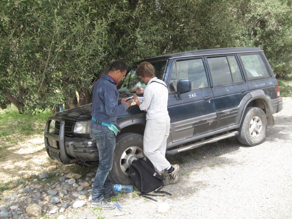


9 How to... Lab-field-lab Target samples on paper Use map and GPS to find approximate location


10 How to... Lab-field-lab Target samples on paper Use map and GPS to find approximate location Drive (all terrain) and walk


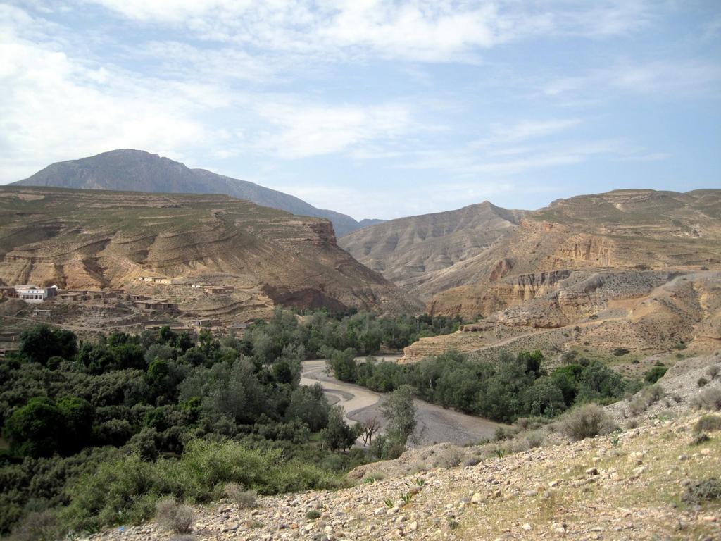
11 Mediterranean section: Messadit


 and")
12 How to... Lab-field-lab Target samples on paper Use map and GPS to find approximate location Drive (all terrain) and walk Compare section with paper


13 How to... Lab-field-lab Target samples on paper Use map and GPS to find approximate location Drive (all terrain) and walk Compare section with paper Observe


14 Messadit rock types Bioturbated mudstone, 7.5m Bioturbated laminated ash


15 Messadit rock types Basal unconformity: conglomerate overlain by laminated ash Halimeda packstone, top of section


16 Messadit rock types High porosity paper-shale diatomite, ~56m

17 How to... Lab-field-lab Target samples on paper Use map and GPS to find approximate location Drive (all terrain) and walk Compare section with paper Observe, sketch


18


19 How to... Lab-field-lab Target samples on paper Use map and GPS to find approximate location Drive (all terrain) and walk Compare section with paper Observe, sketch and log

20 How to... Lab-field-lab Target samples on paper Use map and GPS to find approximate location Drive (all terrain) and walk Compare section with paper Observe, sketch and log
21 What the sediments tell us about Messadit Energy level generally low [O 2 ] variable anoxic bottom water commonly associated with diatomite Coarsening-upwards Water depth evolves shallow-deep-shallow


22 How to... Lab-field-lab Target samples on paper Use map and GPS to find approximate location Drive (all terrain) and walk Compare section with paper Observe, sketch and log Sample and photograph
23 How to... Lab-field-lab Target samples on paper Use map and GPS to find approximate location Drive (all terrain) and walk Compare section with paper Observe, sketch and log Sample and photograph Ship it!
 and walk Compare")
24 How to... Lab-field-lab Target samples on paper Use map and GPS to find approximate location Drive (all terrain) and walk Compare section with paper Observe, sketch and log Sample and photograph Ship it! In the lab: washing, picking, cleaning & mass-spec
25

26


27 Correlation Van Assen et al 2006


28 Atlantic section: Ain el Beida


29 Sed response to orbital forcing Ptolemais quarry, Greece Orera section, Spain Punta di Maiata, Sicily, Italy Gibliscemi section, Sicily, Italy

30 Correlation with Mediterranean sections Krijgsman et al 2004

31 Project partners: Bristol (Geography & Chemistry), Glasgow (SUERC) Utrecht (Earth Sciences) and Salamanca (Oceanic Geosciences) Universities and REPSOL (Madrid) Associate partners: Casablanca, CASP, Montpellier, ONYM, Petrostrat, National Oceanography Centre Great training and career prospects in both academia and the oil industry; Fieldwork in Morocco and Spain with additional opportunities for international travel; Excellent EU pay rates (>46,000 / yr) Application form Closing date: 1 st March 2012 Interviews: April 2012 Start: July-Sept 2012 For more details, contact Dr Rachel Flecker (Network Coordinator): r.flecker@bristol.ac.uk MEDGATE An EU-funded Marie Curie Initial Training Network to reconstruct the flow patterns between the Mediterranean and Atlantic 5-10 million years ago, when ~6% of the world's sea salt was precipitated in the Mediterranean. PhD positions Quantitative constraints on the palaeogeographic evolution of the Betic-Riffian corridors from surface and subsurface data Reconstructing the Messinian Betic Strait from sub-surface data in the Guadalquivir basin, Spain Isotopic constraints on patterns of exchange through the Betic-Riffian Straits Assessing the impact of exchange on Mediterranean temperature and salinity Mio-Pleistocene reconstruction of Mediterranean Outflow through the Gulf of Cadiz Faunal constraints on margin to deep basin correlation across the Levantine continental margin during the MSC Reconstruction of surface and deep water environments along the Riffian Portal during the MSC Modelling gateway evolution and its impact on Mediterranean salinity and circulation Modelling the impact of Late Miocene MOW on ocean circulation in the Atlantic Post-doc position Mio-Pliocene evolution of the western end of the Moroccan Corridor, offshore Rharb Basin
Sierro F.J. 1, Ledesma S. 2 and Flores J.A. 1
 Astrobiochronology of Late Neogene deposits near the Strait of Gibraltar (SW Spain). Implications for the tectonic control of the Messinian Salinity Crisis. Sierro F.J. 1, Ledesma S. 2 and Flores J.A.
Did the Messinian Salinity Crisis affect global climate? Ruža Ivanović, Paul Valdes, Rachel Flecker & Marcus Gutjahr, University of Bristol, UK
 Did the Messinian Salinity Crisis affect global climate? Ruža Ivanović, Paul Valdes, Rachel Flecker & Marcus Gutjahr, University of Bristol, UK The Messinian Salinity Crisis Normal salinity Sapropel-Marl
Did Mediterranean Outflow Water affect global climate during the Messinian?
 Did Mediterranean Outflow Water affect global climate during the Messinian? Ruža F. Ivanović A dissertation submitted to the University of Bristol in accordance with the requirements of the degree of Doctor
Chapter 1. Introduction and summary. A brief history of sapropels. On the origin of sapropels
 Introduction and summary A brief history of sapropels The word "sapropel" first appears in the literature in 1904, when Potonié mentions that Prof. Dr. Schulze suggested that this word should be used as
TEMPERATE AND TROPICAL SHELF- CARBONATE SEDIMENTATION IN THE WESTERN MEDITERRANEAN DURING THE NEOGENE: CLIMATIC AND PALAEOCEANOGRAPHIC IMPLICATIONS
 TEMPERATE AND TROPICAL SHELF- CARBONATE SEDIMENTATION IN THE WESTERN MEDITERRANEAN DURING THE NEOGENE: CLIMATIC AND PALAEOCEANOGRAPHIC IMPLICATIONS JOSÉ M. MARTÍN 1, JUAN C. BRAGA 1, ISABEL M. SÁNCHEZ-ALMAZO
EGAS. Ministry of Petroleum
 EGAS Ministry of Petroleum EGAS Ministry of Petroleum About The Block Location: N. Thekah offshore block is located at about 56 km to the north of the Mediterranean shore line, 85 km to the north west
(Brown & Loucks, 2009)
") SECARB Phase 3, Task 15 Geological CO 2 Sequestration Capacity Estimate Offshore Northern Gulf of Mexico March 9, 2011 Prepared by David L. Carr Project Team: Cari Breton, GIS Analyst David L. Carr, Reservoir
SECARB Phase 3, Task 15 Geological CO 2 Sequestration Capacity Estimate Offshore Northern Gulf of Mexico March 9, 2011 Prepared by David L. Carr Project Team: Cari Breton, GIS Analyst David L. Carr, Reservoir
The oil potential of the Tripoli Formation (pre-messinian Evaporites) in the SE Spain: case of study of the Níjar, Híjar and Lorca basins
 in the SE Spain: case of study of the Níjar, Híjar and Lorca basins") The oil potential of the Tripoli Formation (pre-messinian Evaporites) in the SE Spain: case of study of the Níjar, Híjar and Lorca basins Author: Carlos Español Espinel Directors: Albert Permanyer Bastardas
The oil potential of the Tripoli Formation (pre-messinian Evaporites) in the SE Spain: case of study of the Níjar, Híjar and Lorca basins Author: Carlos Español Espinel Directors: Albert Permanyer Bastardas
EGAS. Ministry of Petroleum
 EGAS Ministry of Petroleum EGAS Ministry of Petroleum About The Block Location: N. El Arish offshore block is located in the extreme eastern part of the Egypt s economic water border and bounded from the
Hydrocarbon Potential of the Marginal Fields in Niger Delta Oza Field, a case study*
 Hydrocarbon Potential of the Marginal Fields in Niger Delta Oza Field, a case study* J.N. Sahu 1, C.H.V. Satya Sai 1, V. Chintamani 1 and C. Vishnu Vardhan 1 Search and Discovery Article #20182 (2012)*
Section 21.1 pp What is Climate?
 Section 21.1 pp. 466 468 What is Climate? Set a Purpose: TE, p. 466 Reading Study Guide, p. 73 More about How Climate Controls Interact TE, p. 466 Differentiating ion Reading Support: TE, p. 466 Critical
Blocks 31, 32, 33, 34, 35 & 36/03 Southeast Offshore Vietnam
 Blocks 31, 32, 33, 34, 35 & 36/03 Southeast Offshore Vietnam Block 31 32 33 34 35 36/03 Area (km 2) 5,036 4,440 4,630 4,700 4,630 2,950 Sea level (m) 20 20-30 30-40 50 50 50 Seismic 2D (km) 1,294 685 431
23/03/2017. Modern versus ancient controls on sedimentary systems. the present is not always the key to the past
 Modern versus ancient controls on sedimentary systems the present is not always the key to the past and: many people (also geologists) only see what they know Uniformitarianism The present is the key to
GLG101: What-To-Know List
 Exam 3, Page 1 GLG101: What-To-Know List (Derived from Before You Leave This Page Lists) This list is intended to guide your reading and to help you prepare for the online multiple-choice quizzes. Each
v Hypothesis: The uplift of the Tibetan Plateau is an active driver for global cooling of the Cenozoic period By Roslyn Gober 11 February 2015
 Objective Uplift of Tibetan Plateau as Active Driver for Cenozoic Climate Change v Use Paleoarchives from the Tibetan Plateau to support the uplift weathering hypothesis for global cooling over the last
Neogene Uplift of The Barents Sea
 Neogene Uplift of The Barents Sea W. Fjeldskaar A. Amantov Tectonor/UiS, Stavanger, Norway FORCE seminar April 4, 2013 The project (2010-2012) Funding companies Flat Objective The objective of the work
Semi-enclosed seas. Estuaries are only a particular type of semi-enclosed seas which are influenced by tides and rivers
 Semi-enclosed seas Estuaries are only a particular type of semi-enclosed seas which are influenced by tides and rivers Other semi-enclosed seas vary from each other, mostly by topography: Separated from
The Messinian salinity crisis: from geology to geobiology
 RCMNS INTERIM COLLOQUIUM The Messinian salinity crisis: from geology to geobiology 25-28 September, 2014 Torino - Italy ABSTRACT BOOK Edited by F. DELA PIERRE, F. LOZAR & M. NATALICCHIO I This volume should
Geology of the Hawaiian Islands
 Geology of the Hawaiian Islands Class 12 19 February 2004 A B C D F 97 94 92 91 88 87 86 85 85 84 82 77 73 73 mean 66 64 60 69 60 57 51 29 Exam Scores Mean = 71 Median = 82/77 Any Questions? Sedimentary
Israel: Seeing Deeper Imaging new play concepts with Clari-Fi broadband reprocessing
 Israel: Seeing Deeper Imaging new play concepts with Clari-Fi broadband reprocessing Alex Birch-Hawkins Interpretation Geophysicist 12 th December 2016 Contents TGS in Israel Geological Overview Exploration
Last Time. Submarine Canyons and Fans. Turbidites. MAS 603: Geological Oceanography. Lecture 16: Greenhouse vs. Icehouse Earths
 UNIVERSITY OF SOUTH ALABAMA Last Time MAS 603: Geological Oceanography Lecture 16: Greenhouse vs. Icehouse Earths Submarine Fans Definition and morphology Transport mechanisms (density currents) Submarine
Subsurface Geology and Resource Exploration
 LAB 11. Subsurface Geology and Resource Exploration Locating earth resources such as aluminum, copper, gold and gemstones has been an important job for geologists for a long time. This lab deals with the
Unit 5 Possible Test Questions Mesozoic and Cenozoic Eras HISTORICAL GEOLOGY
 Revised 8/16 Unit 5 Possible Test Questions Mesozoic and Cenozoic Eras HISTORICAL GEOLOGY Mesozoic Era Eons, Eras and Periods 1. List the Mesozoic periods in order (oldest to youngest). End of the Paleozoic
Understanding Earth Fifth Edition
 Understanding Earth Fifth Edition Grotzinger Jordan Press Siever Chapter 5: SEDIMENTATION: Rocks Formed by Surface Processes Lecturer: H Mohammadzadeh Assistant professors, Department of Geology, FUM Copyright
Joides Resolution at Hong-Kong
 Report from Iván Hernández-Almeida, post-doc at the Oeschger Centre for Climate Change Research/Institute of Geography, University of Bern. Shipboard Micropaleontologist (radiolarian specialist) on IODP
Sequence Stratigraphy as a tool for water resources management in alluvial coastal aquifers: application to the Llobregat delta (Barcelona, Spain)
") Sequence Stratigraphy as a tool for water resources management in alluvial coastal aquifers: application to the Llobregat delta (Barcelona, Spain) Desiré Gàmez Torrent December 2007 CHAPTER 1: Introduction
Sequence Stratigraphy as a tool for water resources management in alluvial coastal aquifers: application to the Llobregat delta (Barcelona, Spain) Desiré Gàmez Torrent December 2007 CHAPTER 1: Introduction
BALOCHISTAN FOLDBELT BASIN
 INTRODUCTION BALOCHISTAN FOLDBELT BASIN The Kharan-3 block is located in the Kharan Trough of Balochistan Basin. GEOLOGICAL SETTING The Balochistan Province is an Upper Cretaceous to Recent structurally
Short Cruise Report. RV MARIA S. MERIAN Cruise MSM15/5
 Ingo Grevemeyer Leibniz Institut für Meereswissenschaften IFM-GEOMAR Abt. Marine Geodynamik Wischhofstraße 1-3 D-24148 Kiel Tel: +49 431 600 2336 Fax: +49 431 600 2922 Email: igrevemeyer@ifm-geomar.de
Contourites and associated sediments controlled by deep-water circulation processes: State of the art and future considerations.
 Contourites and associated sediments controlled by deep-water circulation processes: State of the art and future considerations. Marine Geology 352 (2014) 111 154 Michele Rebesco, F. Javier Hernández-Molina,
Small area of the ocean that is partially surrounded by land. The Ocean Basins. Three Major Oceans. Three Major Oceans. What is a SEA?
 The Ocean Basins How Deep is the Ocean? 1 2 Three Major Oceans Three Major Oceans Pacific Atlantic the shallowest ocean (3.3km average depth) Indian second shallowest ocean (3.8km average depth) Pacific
MAR 110 LECTURE #10 The Oceanic Conveyor Belt Oceanic Thermohaline Circulation
 1 MAR 110 LECTURE #10 The Oceanic Conveyor Belt Oceanic Thermohaline Circulation Ocean Climate Temperature Zones The pattern of approximately parallel oceanic surface isotherms (lines of constant temperature)
Unit 8 Test Review -- Oceanography
 Unit 8 Test Review -- Oceanography Multiple Choice Identify the choice that best completes the statement or answers the question. D 1. A large body of saline water that may be surrounded by land is a(n)
ATOC 5051 INTRODUCTION TO PHYSICAL OCEANOGRAPHY. Lecture 2
 ATOC 5051 INTRODUCTION TO PHYSICAL OCEANOGRAPHY Lecture 2 Ocean basins and relation to climate Learning objectives: (1)What are the similarities and differences among different ocean basins? (2) How does
Seismic stratigraphy, some examples from Indian Ocean, interpretation of reflection data in interactive mode
 Seismic stratigraphy, some examples from Indian Ocean, interpretation of reflection data in interactive mode K. S. Krishna National Institute of Oceanography, Dona Paula, Goa-403 004. krishna@nio.org Seismic
The West Mediterranean Salt Basin A Future Petroleum Producing Province?*
 The West Mediterranean Salt Basin A Future Petroleum Producing Province?* Glyn Roberts 1 and Trond Christoffersen 2 Search and Discovery Article #50791 (2013) Posted June 17, 2013 *Adapted from extended
SMR/ ICTP Oceanography Advanced School. 30 April - 11 May, 2007
 SMR/1837-9 2007 ICTP Oceanography Advanced School 30 April - 11 May, 2007 Thermohaline circulation of mediterranean sea sensitivity to wind stress, diffusion,strait dynamics, etc.. V. Artale ENEA C.R.
Biostratigraphic and Lithostratigraphic Correlation of Sedimentary Strata in the Atlantic Coastal Plain
 Biostratigraphic and Lithostratigraphic Correlation of Sedimentary Strata in the Atlantic Coastal Plain Introduction to the Atlantic Coastal Plain (Please read this page prior to doing the lab) The Atlantic
OCEANOGRAPHY CURRICULUM. Unit 1: Introduction to Oceanography
 Chariho Regional School District - Science Curriculum September, 2016 OCEANOGRAPHY CURRICULUM Unit 1: Introduction to Oceanography OVERVIEW Summary In this unit students will be introduced to the field
Almost of Earth is covered by water. On a map, the continents appear as huge islands surrounded by a vast global ocean.
 Earth s Oceans & Ocean Floor Date: Feelin Blue What are Earth s five main oceans? Almost of Earth is covered by water. On a map, the continents appear as huge islands surrounded by a vast global ocean.
Toward Environmental Predictions MFSTEP. Executive summary
 Research Project co-funded by the European Commission Research Directorate-General 5 th Framework Programme Energy, Environment and Sustainable Development Contract No. EVK3-CT-2002-00075 Project home
Deposition of Widespread or Thick Precipitates
 Chapter 8 Deposition of Widespread or Thick Precipitates An evaporite is sedimentary rock composed primarily of minerals and chemicals. It is produced by a saline solution and is a result of extensive
Outline 23: The Ice Ages-Cenozoic Climatic History
 Outline 23: The Ice Ages-Cenozoic Climatic History Continental Glacier in Antarctica Valley Glaciers in Alaska, note the moraines Valley Glaciers in Alaska, note the moraines Mendenhall Glacier, Juneau,
The Eocene Gir Formation of the Ghani and Ed Dib Fields, Eastern Libya -An example of "Virtual Core Study"*
 The Eocene Gir Formation of the Ghani and Ed Dib Fields, Eastern Libya -An example of "Virtual Core Study"* Henry Williams 1 Search and Discovery Article #20288 (2014) Posted December 29, 2014 *Adapted
ATOC OUR CHANGING ENVIRONMENT
 ATOC 1060-002 OUR CHANGING ENVIRONMENT Class 22 (Chp 15, Chp 14 Pages 288-290) Objectives of Today s Class Chp 15 Global Warming, Part 1: Recent and Future Climate: Recent climate: The Holocene Climate
Tectonic control on past circulation of the Mediterranean Sea: A model study of the Late Miocene
 PALEOCEANOGRAPHY, VOL. 19,, doi:10.1029/2003pa000956, 2004 Correction published 14 May 2004 Tectonic control on past circulation of the Mediterranean Sea: A model study of the Late Miocene P. Th. Meijer
Depositional Environments and Hydrocarbon Potential of Northern Ionian Sea
 Depositional Environments and Hydrocarbon Potential of Northern Ionian Sea Vasiliki Kosmidou George Makrodimitras Nick Papatheodorou Contents Area of Interest Studied Dataset Workflow SWIT and Paleolatitude
Where is all the water?
 Where is all the water? The distribution of water at the Earth's surface % of total Oceans 97.25 Ice caps and glaciers 2.05 Groundwater 0.68 Lakes 0.01 Soils 0.005 Atmosphere (as vapour) 0.001 Rivers 0.0001
Sediment and sedimentary rocks Sediment
 Sediment and sedimentary rocks Sediment From sediments to sedimentary rocks (transportation, deposition, preservation and lithification) Types of sedimentary rocks (clastic, chemical and organic) Sedimentary
SIO 210 Introduction to Physical Oceanography Mid-term examination Wednesday, November 2, :00 2:50 PM
 SIO 210 Introduction to Physical Oceanography Mid-term examination Wednesday, November 2, 2005 2:00 2:50 PM This is a closed book exam. Calculators are allowed. (101 total points.) MULTIPLE CHOICE (3 points
Maturity Modeling of Gomin and South Gomin fields Southern Pattani Basin, Gulf of Thailand
 Maturity Modeling of Gomin and South Gomin fields Southern Pattani Basin, Gulf of Thailand Patinya Jaithan Petroleum Geoscience Program, Department of Geology, Faculty of Science, Chulalongkorn University,
Lecture 3 questions Temperature, Salinity, Density and Circulation
 Lecture 3 questions Temperature, Salinity, Density and Circulation (1) These are profiles of mean ocean temperature with depth at various locations in the ocean which in the following (a, b, c) figures
Plio-Pleistocene Geology
 UNIVERSITY OF SOUTH ALABAMA GY 112: Earth History Plio-Pleistocene Geology Instructor: Dr. Douglas W. Haywick Last Time A) Cenozoic Tectonics Western North American tectonic provinces Plateaus and canyons
East Africa Transform Margin The View from Tanzania and Madagascar
 East Africa Transform Margin The View from Tanzania and Madagascar Richard Higgins and Mark Sofield 10 th PESGB/HGS Conference on African E & P, London, September 7-8, 2011 Acknowledgements Legal Notice:
The Eocene Gir Formation of the Ghani and Ed Dib Fields, Eastern Libya - an example of "Virtual Core Study"
 The Eocene Gir Formation of the Ghani and Ed Dib Fields, Eastern Libya - an example of "Virtual Core Study" Henry Williams*, Suncor Energy Inc., Calgary, AB hwilliams@suncor.com Summary The Gir Formation
SEDIMENTARY BASINS BASIN TYPES ACCORDING TO TECTONIC. by Prof. Dr. Abbas Mansour
 SEDIMENTARY BASINS BASIN TYPES ACCORDING TO TECTONIC by Prof. Dr. Abbas Mansour B. Convergent plate margins 10. STABLE CONTINENTAL INTERIOR BASIN E.g. Lake Eyre Basin Intracratonic (= within stable continental
Paleoceanography II Telluric Effects on Oceanography
 Paleoceanography II Telluric Effects on Oceanography Geological Oceanography OCN 622 Gary McMurtry Telluric Effects Tellus = Earth Distribution of Continents at 100 Ma BP and Present Comparison of Earth
Dalhousie University- Petroleum Geoscience Field Methods- Trinidad Summary Report
 Dalhousie University- Petroleum Geoscience Field Methods- Trinidad Summary Report Submitted to: Offshore Energy Research Association of Nova Scotia (OERA) To fulfill requirements of the Undergraduate Student
Ministry of Oil and Minerals Petroleum Exploration & Production Authority BLOCK 85 (Al Uqlah North)
") Ministry of Oil and Minerals Petroleum Exploration & Production Authority BLOCK 85 (Al Uqlah North) The Al Uqlah North Block (85) occupies an area of 597 km 2 in the Sabatayn Basin in the province of Shabwah
Ministry of Oil and Minerals Petroleum Exploration & Production Authority BLOCK 85 (Al Uqlah North) The Al Uqlah North Block (85) occupies an area of 597 km 2 in the Sabatayn Basin in the province of Shabwah
Thermohaline variability of the North Ionian and South Adriatic Sea in
 Thermohaline variability of the North Ionian and South Adriatic Sea in 2013-2016 Κλικ για προσθήκη κειμένου Zoi kokkini, P. - M. Poulain, R. Gerin, E. Mauri and G. Notarstefano 6th Euro-Argo Users Meeting,
Byblos & the Sea - an HFF funded project Summary report: Sea Survey Mission 7 - Sept. 2016
 Byblos & the Sea - an HFF funded project Summary report: Sea Survey Mission 7 - Sept. 2016 In the framework of the research program Byblos and the Sea a marine remote sensing and sampling survey was carried
Coastal Oceanography. Coastal Oceanography. Coastal Waters
 Coastal Oceanography Coastal Oceanography 95% of ocean life is in coastal waters (320 km from shore) Estuaries and wetlands are among most productive ecosystems on Earth Major shipping routes, oil and
Exploration, Drilling & Production
 Nontechnical Guide to PETMOLEUM Geology, Exploration, Drilling & Production Third Edition Norman J. Hyne, Ph.D. Contents Preface *i Introduction 1 The Nature of Gas and Oil 1 Petroleum 1 The Chemistry
Kilometre-Scale Uplift of the Early Cretaceous Rift Section, Camamu Basin, Offshore North-East Brazil*
 Kilometre-Scale Uplift of the Early Cretaceous Rift Section, Camamu Basin, Offshore North-East Brazil* Iain Scotchman 1 and Dario Chiossi 2 Search and Discovery Article #50183 (2009) Posted May 20, 2009
Particle fluxes along the western Svalbard margin: one-year mooring deployment
 Particle fluxes along the western Svalbard margin: one-year mooring deployment L. Langone I. Conese, F. Giglio, S. Miserocchi, S. Aliani (CNR-ISMAR) Preliminary results from experiments: a) Offshore Storfjorden
1 MAR 110 Lecture #1 Introduction to Oceans Hazards SECTION I Volcano, Earthquake, and Tsunami Hazards
 1 MAR 110 Lecture #1 Introduction to Oceans Hazards SECTION I Volcano, Earthquake, and Tsunami Hazards Ocean Basin Rim Hazards - Earthquakes Earthquake-Induced Oil Storage Tank Conflagration Valdez, Alaska.(NG)
- 5 - Figure 2. A. Location map for the Cibao Valley, northern Dominican Republic with generalized geology and major features (Erikson et al., 1998).
.") Diana Ortega-Ariza is a PhD student at the University of Kansas. Her dissertation work proposes to develop absolute age-constrained sequence stratigraphic frameworks and construct rock-based quantitative
Diana Ortega-Ariza is a PhD student at the University of Kansas. Her dissertation work proposes to develop absolute age-constrained sequence stratigraphic frameworks and construct rock-based quantitative
Chatham Rise Phosphorite. Observations from the literature
 Chatham Rise Phosphorite Observations from the literature Content 1. Where is it? 2. Why is it there? i. Stratigraphy ii. Structure iii. GONDWANA iv. Ocean circulation v. Ocean fronts 3. The answer...
Weather & Ocean Currents
 Weather & Ocean Currents Earth is heated unevenly Causes: Earth is round Earth is tilted on an axis Earth s orbit is eliptical Effects: Convection = vertical circular currents caused by temperature differences
Emerging Needs and Opportunities in Ocean Remote Sensing
 Emerging Needs and Opportunities in Ocean Remote Sensing Christine Gommenginger National Oceanography Centre, Southampton With thanks to: Chris Banks, Val Byfield, Paolo Cipollini, Nadim Dayoub, Giuseppe
Dynamics of Boundary Currents and Marginal Seas
 Dynamics of Boundary Currents and Marginal Seas W. E. Johns University of Miami, RSMAS/MPO 4600 Rickenbacker Causeway, Miami, Florida 33149-1098 Phone (305)361-4054; fax: (305)361-4696; email: wjohns@rsmas.miami.edu
Lecture 26: Marine Geology Read: Chapter 21 Homework due December 3
 Learning Objectives (LO) Lecture 26: Marine Geology Read: Chapter 21 Homework due December 3 What we ll learn today:! 1. Describe the world s five oceans! 2. Understand patterns of ocean circulation! 3.
Cause, evidence, and significance?
 Sea Level changes; a variety of types Cause, evidence, and significance? Relatively slow, long term changes with some exceptions 542my Present 1 Some exceptions to the Relatively slow : The Mediterranean
Continental Hydrology, Rapid Climate Change, and the Intensity of the Atlantic MOC: Insights from Paleoclimatology
 Continental Hydrology, Rapid Climate Change, and the Intensity of the Atlantic MOC: Insights from Paleoclimatology W.R. Peltier Department of Physics University of Toronto WOCE derived N-S salinity section
Carbon Exchanges between the Continental Margins and the Open Ocean
 Carbon Exchanges between the Continental Margins and the Open Ocean Outline: 1. Introduction to problem 2. Example of how circulation can export carbon to open ocean 3. Example of how particle transport
The Kingfisher Field, Uganda - A Bird in the Hand! S R Curd, R Downie, P C Logan, P Holley Heritage Oil plc *
 A Bird in the Hand! EXTENDED ABSTRACT The Kingfisher Field, Uganda - A Bird in the Hand! Heritage Oil plc * The Kingfisher Field lies on Uganda s western border beneath Lake Albert, situated in the western
High-resolution Sequence Stratigraphy of the Glauconitic Sandstone, Upper Mannville C Pool, Cessford Field: a Record of Evolving Accommodation
 Page No. 069-1 High-resolution Sequence Stratigraphy of the Glauconitic Sandstone, Upper Mannville C Pool, Cessford Field: a Record of Evolving Accommodation Thérèse Lynch* and John Hopkins, Department
Version2 Fall True/False Indicate whether the sentence or statement is true or false.
 Version2 Fall 2004 True/False Indicate whether the sentence or statement is true or false. 1. Short residence time elements are found in the greatest concentration near their point of removal from the
NAME: GEL 109 Final Winter 2010
 GEL 109 Final Winter 2010 1. The following stratigraphic sections represents a single event followed by the slow accumulation of background sedimentation of shale. Describe the flows that produced the
1 Earth s Oceans. TAKE A LOOK 2. Identify What are the five main oceans?
 CHAPTER 13 1 Earth s Oceans SECTION Exploring the Oceans BEFORE YOU READ After you read this section, you should be able to answer these questions: What affects the salinity of ocean water? What affects
Hydrocarbon Exploration in Morocco: Current Activities and Opportunities. H. Jabour
 Hydrocarbon Exploration in Morocco: Current Activities and Opportunities H. Jabour O N H Y M February 06, 2013 Outline Background Hydrocarbon potential of Morocco Non-Conventional Hydrocarbon Resources
ANOTHER MEXICAN EARTHQUAKE! Magnitude 7.1, Tuesday Sept. 19, 2017
 ANOTHER MEXICAN EARTHQUAKE! Magnitude 7.1, Tuesday Sept. 19, 2017 Why is there no oceanic crust older than 200 million years? SUBDUCTION If new oceanic crust is being continuously created along the earth
Bell Ringer. water cycle? gaseous water (water vapor)? How do you know? 1. What are the five components of the
? How do you know? 1. What are the five components of the") Bell Ringer 1. What are the five components of the water cycle? 2. Are clouds composed of liquid water or gaseous water (water vapor)? How do you know? 3. How are glaciers formed? Salt Water - Oceans Characteristics
Bell Ringer 1. What are the five components of the water cycle? 2. Are clouds composed of liquid water or gaseous water (water vapor)? How do you know? 3. How are glaciers formed? Salt Water - Oceans Characteristics
The Sierra Leone-Liberia Emerging Deepwater Province*
 The Sierra Leone-Liberia Emerging Deepwater Province* Joan F. Flinch 1, José L. Huedo 1, Hernán Verzi 1, Héctor González 1, Ricardo Gerster 1, Abdul K. Mansaray 1, L. P. Painuly 1, Leticia Rodriguez-Blanco
Thickness, Compositional and Textural Variability, and Genesis of El-Lajjun Oil Shale, Central Jordan
 Thickness, Compositional and Textural Variability, and Genesis of El-Lajjun Oil Shale, Central Jordan H Alnawafleh 1, D Large 2 & B Spiro 3 1 Department of Mining Engineering, Al-Hussein Bin Talal University,
Climate and Environment
 Climate and Environment Oxygen Isotope Fractionation and Measuring Ancient Temperatures Oxygen Isotope Ratio Cycles Oxygen isotope ratio cycles are cyclical variations in the ratio of the mass of oxygen
Florida s Changing Shape
 Florida s Changing Shape Background: For much of its history, Florida was underwater. At first, Florida consisted solely of the Florida Platform, a limestone base formed from the calcium carbonate remains
Soils, Hydrogeology, and Aquifer Properties. Philip B. Bedient 2006 Rice University
 Soils, Hydrogeology, and Aquifer Properties Philip B. Bedient 2006 Rice University Charbeneau, 2000. Basin Hydrologic Cycle Global Water Supply Distribution 3% of earth s water is fresh - 97% oceans 1%
4th GRADE MINIMUM CONTENTS- SOCIAL SCIENCE UNIT 3: LAND RELIEF
 LAND RELIEF 4th GRADE MINIMUM CONTENTS- SOCIAL SCIENCE UNIT 3: LAND RELIEF The outer layer of the Earth is composed of rocks and minerals. It is called the lithosphere or the Earth s crust. This layer
SEMESTER AT SEA COURSE SYLLABUS. Introduction to Oceanography
 COURSE DESCRIPTION SEMESTER AT SEA COURSE SYLLABUS Introduction to Oceanography More of an exploration of the seas than a class, this course engages students in direct observation, reflection, and analysis.
REGIONAL GEOLOGY IN KHMER BASIN
 CONTENTS 1-Khmere Basin 2-Regional Geology Khmer Basin 3-Regime Tectonic 4-Seismic Database -a/ Acquisition Data -b/ Prospect Angkor -C/ Cross Section Seismic 5-Play Type -a/ Play Schematic -b/ Structure
Seawater Chemistry and Chemical Oceanography. The Universal Solvent. Sphere of Hydration
 Seawater Chemistry and Chemical Oceanography The Universal Solvent Polarity of molecule makes water very effective at hydrating even weakly charged ions Sphere of Hydration Polarity of water molecules
Arthur Saller 1. Search and Discovery Article #51393 (2017)** Posted June 26, Abstract
** Posted June 26, Abstract") PS Mixed Carbonates and Siliciclastics North of the Mahakam Delta, Offshore East Kalimantan, Indonesia* Arthur Saller 1 Search and Discovery Article #51393 (2017)** Posted June 26, 2017 *Adapted from poster
PS Mixed Carbonates and Siliciclastics North of the Mahakam Delta, Offshore East Kalimantan, Indonesia* Arthur Saller 1 Search and Discovery Article #51393 (2017)** Posted June 26, 2017 *Adapted from poster
Messinian astrochronology of the Melilla Basin: Stepwise restriction of the Mediterranean Atlantic connection through Morocco
 Palaeogeography, Palaeoclimatology, Palaeoecology 238 (2006) 15 31 www.elsevier.com/locate/palaeo Messinian astrochronology of the Melilla Basin: Stepwise restriction of the Mediterranean Atlantic connection
Z046 Seismic Characteristics of Gas Migration Structures on the North Atlantic Margin Imaged by High-resolution 3D Seismic
 Z046 Seismic Characteristics of Gas Migration Structures on the North Atlantic Margin Imaged by High-resolution 3D Seismic O.K. Eriksen* (P-Cable 3D Seismic), C. Berndt (IFM-GEOMAR), S. Buenz (University
NAME Lab TA. Introduction to Oceanography, EPSS15 Practice Lecture Exam #1, Fall 2017 Exam#
 NAME Lab TA Introduction to Oceanography, EPSS15 Practice Lecture Eam #1, Fall 2017 Eam# 654321 Instructions 1. PRINT your name and lab TA s name on BOTH the cover sheet of this eam and on the SCANTRON
Telling Geologic Time
 Telling Geologic Time Trilobite fossils these arthropods went extinct during the great extinction at the end of the Permian Period ~250 Ma ka = kilo-annum Ma = Mega-annum Ga = Giga-annum Relative dating
Oceanography Quiz 2. Multiple Choice Identify the choice that best completes the statement or answers the question.
 Oceanography Quiz 2 Multiple Choice Identify the choice that best completes the statement or answers the question. 1. The highest and lowest tides are known as the spring tides. When do these occur? a.
Physical Oceanography
 Physical Oceanography SECTION 15.1 The Oceans In your textbook, read about modern oceanography. For each item in Column A, write the letter of the matching item in Column B. e b c d a Column A 1. German
Plate Tectonics. In 1912 Alfred Wegener ( ) proposed that: the continents were once compressed into a single protocontinent which he called
 proposed that: the continents were once compressed into a single protocontinent which he called") Plate Tectonics In 1912 Alfred Wegener (1880-1930) proposed that: the continents were once compressed into a single protocontinent which he called Pangaea (meaning "all lands"), and over time they have
Plate Tectonics In 1912 Alfred Wegener (1880-1930) proposed that: the continents were once compressed into a single protocontinent which he called Pangaea (meaning "all lands"), and over time they have
Shallow P and S velocity structure, Red Deer, Alberta
 Shallow P and S velocity structure, Red Deer, Alberta P & S velocity structure Don C. Lawton, Meredith A. McArthur, Rachel T. Newrick and Sarah E. Trend ABSTRACT A multioffset vertical seismic profile