ATOC 5051 INTRODUCTION TO PHYSICAL OCEANOGRAPHY. Lecture 2
|
|
|
- Mercy Woods
- 6 years ago
- Views:
Transcription
1 ATOC 5051 INTRODUCTION TO PHYSICAL OCEANOGRAPHY Lecture 2 Ocean basins and relation to climate Learning objectives: (1)What are the similarities and differences among different ocean basins? (2) How does each ocean basin geometry affect ocean circulation & climate, and why?
2 The world s oceans

3 Ocean Beach

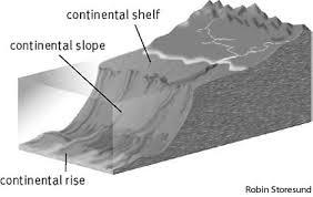
4 1. Common feature of ocean basins Continental Rise: gentler slope than continental slope
5

6 Description of ocean basins Ocean basin: common features Land Open ccean (ridges and trenches) Abyssal Plain Shelf: 7.4% 0-200m; Slope+Rise: 15.9% m; Topography Abyssal Plain: 76.7%, >3000m.
.")
7 The deepest trench in the world s oceans: The Mariana trench in the western Pacific, ~deepest: 11km (Challenger deep). 2,550 km long; Average: 69km wide

8 Interocean ridges:(could affect the flow of deep water) Mid-Atlantic ridge - SW Indian Ridge Central Indian Ridge - Southeast Indian Ridge Pacific Antarctic Ridge - East Pacific Rise.

9 Mid-Atlantic ridge; SW Indian Ridge; Central Indian Ridge; Southeast Indian Ridge; Pacific Antarctic Ridge; East Pacific Rise.
10 2. Differences in ocean basins & effects on circulation and climate The Pacific The Atlantic The Indian Ocean The Arctic Ocean (Some books list The Southern Ocean as an independent ocean. Here, it is included in the first 3 major oceans.)

11 The Pacific OKH Pacific Panama Ross sea c Atlanti SCS Malacca Weddell Indian

12 The Pacific Ocean Zonally: 20,000km Meridional extent: over 15,000km; Area: 178x10 6 km 2 with all adjacent seas Arctic 40% of world s Oceans ~ area of all continents
13 The Pacific The largest. In the tropics, zonally: spans 20,000km (from Malacca strait to Panama); Meridional extent: Bering Strait to Antarctic, over 15,000km; Area: 178x10 6 km 2 with all adjacent seas; Represent 40% of the world ocean surface (equivalent to the area of all continents) Without southern part, 147x10 6 km 2, twice of the Indian Ocean.
14 The Pacific: air-sea interaction Vast ocean: strong air-sea coupling (small continental monsoon effect); El Nino-Southern Oscillation (ENSO) - global climate mode of variability, global impact; also Interdecadal Pacific Oscillation; Mean depth, 4270m; No DEEP water source (away from its S. Ocean); Ridges: Pacific-Antarctic, East Pacific Rise, Emperor Hawaiian Seamounts Ridge, Chile Rise, Nazca Ridge. Main adjacent seas: South China Sea, East China Sea, Sea of Japan, Sea of Okhotsk, Bering Sea,etc.

15 The Atlantic
16 The Atlantic Different from the Pacific: the Atlantic extends both into the Arctic and Antarctic Region; full meridional extent; Zonal: largest extent (Gulf of Mexico-NW Africa), 8300km; Area: 106x10 6 km 2 ; Mean depth: 3300m; Ridges: Mid-Atlantic.
17 The Atlantic The full meridional extent: favors DEEP Water Formation (since the far northern latitude is exposed to the cold air from continent cool the ocean; plus sea ice formation ejects salt; both of which increase surface water density) - important for global thermohaline circulation (thermo-thermal-temperature; haline: salinity; board demo) It has the largest number of adjacent seas. A major adjacent sea - the Mediterranean Sea, produces the Mediterranean water mass. Close to continents: both monsoon and air-sea interaction are important in shaping the climate.
")
18 The Indian Ocean & inter-ocean connections 30N Pacific The Atlantic Agulhas current Indonesian Throughflow (ITF) Supergyre
19 The Indian Ocean Smallest among the three. Meridional extent: 9600km (Antarctic - inner Bay of Bengal); Zonal: 7800km (S. Africa - W. Australia) Area: 74x10 6 km 2 ; Interesting feature: connecting to the Pacific via the Indonesian Throughflow (and through south of Australia-the super gyre), and to the Atlantic via the Agulhas Current;
20 The Indian Ocean North, bounded by Asian subcontinents; seasonally-reversing monsoons are major feature in its climate; air-sea interaction is recently found to be also important, especially for the Indian Ocean Dipole mode; Another interesting feature: northern boundary is in the tropics. => waves forced remotely by the equatorial winds can influence northern coast of the Indian Ocean. Mean depth: 3800m; Ridges: Southwest Indian, Central Indian, Southeast Indian, Ninety East Ridge.

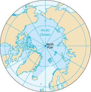
21 The Arctic Ocean
22 The Arctic Ocean Covers the arctic region - smallest, shallow. Area: 14x10 6 km 2 (2USA); Sea ice covered region varies with season; Major connections with the Atlantic: ~1700km wide opening from Greenland across to Iceland, Faroe Islands and Scotland; Minor opening: Canadian Archipelago. Connection with the Pacific: Bering Strait. Narrow, shallow (45m deep and 85km wide).
23 The Arctic Ocean & inter-ocean connection Sea ice export to the North Atlantic; its melting and freezing affect deep water formation and thus global thermohaline circulation; sea ice concentration area affects albedo climate; Atlantic warm water can also flows to the Arctic, affects sea ice formation/melting. Mean depth: central basins: m. Separate into a few basins by Ridges. Major Ridges: Alpha and Mendeleyev Ridge, Lomonossov Ridge, and the Arctic Mid-Ocean Ridge (Nansen Ridge).
24 Summary The world s oceans have commons features. What are they? The world s oceans: the Pacific, Atlantic, Indian and Arctic The Pacific: largest in size, climate mode (why?) The Atlantic: Largest meridional extent, thermohaline circulation affecting global climate; The Indian Ocean: most region located in the tropics northern boundary: Asian land monsoon (why?) The Arctic Ocean: mostly covered by sea ice; sea ice concentration affect albedo & air-sea heat exchange; laterally, it exchanges water& ice with the Atlantic and the Pacific.
Proposed draft marine bioregions
 Proposed draft marine bioregions 1. PROPOSED PELAGIC BIOREGIONS Map 1. Proposed draft pelagic bioregions List of proposed pelagic bioregions: 1. Agulhas Current 2. Antarctic 3. Antarctic Polar Front 4.
Arctic oceanography; the path of North Atlantic Deep Water
 Chapter 7 Arctic oceanography; the path of North Atlantic Deep Water The importance of the Southern Ocean for the formation of the water masses of the world ocean poses the question whether similar conditions
Earth Planet Water. Earth 71% Formation of Water on Planet. Nearly ¾ of Earth s surface is covered by liquid water More covered by solid water
 Earth Planet Water 71% Nearly ¾ of Earth s surface is covered by liquid water More covered by solid water Where is it from? Formation of Water on Planet Earth Combination of volcanic activity and strong
The Ocean Floor THE VAST WORLD OCEAN
 OCEANOGRAPHY Name Color all water LIGHT BLUE. Color all land LIGHT GREEN. Label the 5 Oceans: Pacific, Atlantic, Indian, Arctic, Antarctic. Label the 7 Continents: N.America, S.America, Europe, Asia, Africa,
The surface of the ocean floor is as varied as the land. The five major oceans, from largest to smallest, are
 11.1 Ocean Basins The surface of the ocean floor is as varied as the land. The five major oceans, from largest to smallest, are w the Pacific w the Atlantic w the Indian w the Southern w the Arctic The
Map Elements & The 5 Oceans
 Map Elements & The 5 Oceans Latitude and Longitude Longitude lines run north and south. Latitude lines run east and west. The lines measure distances in degrees. Latitude Longitude Where is 0 degrees?
GEOGRAPHY OCEAN TYPES OF OCEANS Economics Importance of Oceans to Man Relief of the ocean floor Continental Shelf Importance of Continental Shelf
 GEOGRAPHY OCEAN The oceans and seas occupy about 71 per cent of the total earth surface which means that about 29 percent of the earth s surface is occupied by the land. The study of the oceans. The water
SIO 210 Final Exam Dec Name:
 SIO 210 Final Exam Dec 8 2006 Name: Turn off all phones, pagers, etc... You may use a calculator. This exam is 9 pages with 19 questions. Please mark initials or name on each page. Check which you prefer
Climate Outlook for October 2017 March 2018
 The APEC CLIMATE CENTER Climate Outlook for October 2017 March 2018 BUSAN, 25 September 2017 The synthesis of the latest model forecasts for October 2017 to March 2018 (ONDJFM) from the APEC Climate Center
Surface Circulation Ocean current Surface Currents:
 All Write Round Robin G1. What makes up the ocean water? G2. What is the source of the salt found in ocean water? G3. How does the water temperature affect the density of ocean water? G4. How does the
Directed Reading. Section: Ocean Currents. a(n). FACTORS THAT AFFECT SURFACE CURRENTS
. FACTORS THAT AFFECT SURFACE CURRENTS") Skills Worksheet Directed Reading Section: Ocean Currents 1 A horizontal movement of water in a well-defined pattern is called a(n) 2 What are two ways that oceanographers identify ocean currents? 3 What
Skills Worksheet Directed Reading Section: Ocean Currents 1 A horizontal movement of water in a well-defined pattern is called a(n) 2 What are two ways that oceanographers identify ocean currents? 3 What
SIO 210 Final Exam December 10, :30 2:30 NTV 330 No books, no notes. Calculators can be used.
 SIO 210 Final Exam December 10, 2003 11:30 2:30 NTV 330 No books, no notes. Calculators can be used. There are three sections to the exam: multiple choice, short answer, and long problems. Points are given
SIO 210 Final examination Answer Key for all questions except Daisyworld. Wednesday, December 10, PM Name:
 SIO 210 Final examination Answer Key for all questions except Daisyworld. Wednesday, December 10, 2008 3-6 PM Name: This is a closed book exam. You may use a calculator. There are two parts: Talley (weighted
Lecture 9: General Circulation
 Lecture 9: General Circulation JS JP Hadley Cell Ferrel Cell (driven by eddies) Polar Cell L H L H Three-Cell Circulation in the Atmosphere Gyres in the Oceans Single-Cell Model: Explains Why There are
Lecture 9: General Circulation Explains Why There are Tropical Easterlies
 Lecture 9: General Circulation Single-Cell Model: Explains Why There are Tropical Easterlies JS JP Hadley Cell Ferrel Cell (driven by eddies) Polar Cell Without Earth Rotation With Earth Rotation L H L
Chapter 02 The Sea Floor
 Chapter 02 The Sea Floor Multiple Choice Questions 1. One of the following is not one of the world's major ocean basins: A. Atlantic Ocean B. Arctic Ocean C. Indian Ocean D. Antarctic Ocean E. Pacific
The Southern Ocean. Copyright 2010 LessonSnips
 The Southern Ocean Even though oceanographers currently define five oceans on earth, in reality there is but one ocean. The fact that the ocean is one single entity and the divisions of the ocean are man-made
1. Oceans. Example 2. oxygen.
 1. Oceans a) Basic facts: There are five oceans on earth, making up about 72% of the planet s surface and holding 97% of the hydrosphere. Oceans supply the planet with most of its oxygen, play a vital
MARINE GEOLOGY & GEOGRAPHY
 MARINE GEOLOGY & GEOGRAPHY Bathymetry BATHYMETRY BATHYMETRY THE UNDERWATER EQUIVALENT TO TOPOGRAPHY THE STUDY OF WATER DEPTH A BATHYMETRIC MAP SHOWS FLOOR RELIEF OR TERRAIN AS CONTOUR LINES Bathymetry
Climate Outlook for March August 2018
 The APEC CLIMATE CENTER Climate Outlook for March August 2018 BUSAN, 26 February 2018 The synthesis of the latest model forecasts for March to August 2018 (MAMJJA) from the APEC Climate Center (APCC),
Upper Ocean Circulation
 Upper Ocean Circulation C. Chen General Physical Oceanography MAR 555 School for Marine Sciences and Technology Umass-Dartmouth 1 MAR555 Lecture 4: The Upper Oceanic Circulation The Oceanic Circulation
Small area of the ocean that is partially surrounded by land. The Ocean Basins. Three Major Oceans. Three Major Oceans. What is a SEA?
 The Ocean Basins How Deep is the Ocean? 1 2 Three Major Oceans Three Major Oceans Pacific Atlantic the shallowest ocean (3.3km average depth) Indian second shallowest ocean (3.8km average depth) Pacific
Geography of the world s oceans and major current systems. Lecture 2
 Geography of the world s oceans and major current systems Lecture 2 WHY is the GEOMORPHOLOGY OF THE OCEAN FLOOR important? (in the context of Oceanography) WHY is the GEOMORPHOLOGY OF THE OCEAN FLOOR important?
Weather & Ocean Currents
 Weather & Ocean Currents Earth is heated unevenly Causes: Earth is round Earth is tilted on an axis Earth s orbit is eliptical Effects: Convection = vertical circular currents caused by temperature differences
MAR 110 LECTURE #10 The Oceanic Conveyor Belt Oceanic Thermohaline Circulation
 1 MAR 110 LECTURE #10 The Oceanic Conveyor Belt Oceanic Thermohaline Circulation Ocean Climate Temperature Zones The pattern of approximately parallel oceanic surface isotherms (lines of constant temperature)
OCEANOGRAPHY MEASURING THE DEPTHS OF THE OCEANS
 Water 2 page 1 OCEANOGRAPHY Name If all the water was drained from the ocean basins, what kind of surface would be revealed? It would not be the quiet, subdued topography as was once thought, but a surface
Oceans I Notes. Oceanography
 Oceans I Notes Outlines on the front table Oceanography the science of our oceans that mixes biology, geology, chemistry, and physics (among other sciences) to unravel the mysteries of our seas. Divisions
Earth Science 11 Learning Guide Unit Complete the following paragraph about the ocean and ocean water with the following words:
 Earth Science 11 Learning Guide Unit 8 Name: 8-1 Ocean Properties 1. Complete the following paragraph about the ocean and ocean water with the following words: thousand chloride 70% salinity water sodium
CHAPTER 7 Ocean Circulation Pearson Education, Inc.
 CHAPTER 7 Ocean Circulation 2011 Pearson Education, Inc. Types of Ocean Currents Surface currents Deep currents 2011 Pearson Education, Inc. Measuring Surface Currents Direct methods Floating device tracked
Oceanography is the scientific study of oceans Oceans make up over 70% of the Earth s surface
 Oceanography Oceanography is the scientific study of oceans Oceans make up over 70% of the Earth s surface An ocean must be large and have features which set it apart from other oceans (currents, water
On the world-wide circulation of the deep water from the North Atlantic Ocean
 Journal of Marine Research, 63, 187 201, 2005 On the world-wide circulation of the deep water from the North Atlantic Ocean by Joseph L. Reid 1 ABSTRACT Above the deeper waters of the North Atlantic that
TROPICAL-EXTRATROPICAL INTERACTIONS
 Notes of the tutorial lectures for the Natural Sciences part by Alice Grimm Fourth lecture TROPICAL-EXTRATROPICAL INTERACTIONS Anomalous tropical SST Anomalous convection Anomalous latent heat source Anomalous
Almost of Earth is covered by water. On a map, the continents appear as huge islands surrounded by a vast global ocean.
 Earth s Oceans & Ocean Floor Date: Feelin Blue What are Earth s five main oceans? Almost of Earth is covered by water. On a map, the continents appear as huge islands surrounded by a vast global ocean.
Land Bridge for migration of mammals and people? Arctic Change Woodgate Paleo role of Bering Strait
 Paleo role of Bering Strait Stabilizer for World Climate? (DeBoer & Nof, 2004) - if Bering Strait is open, excess freshwater in the Atlantic (from, for example, ice sheet collapse) can vent through the
UNIT V WATER (OCEANS)
") UNIT V WATER (OCEANS) This unit deals with Hydrological Cycle Oceans submarine relief; distribution of temperature and salinity; movements of ocean water-waves, tides and currents CHAPTER WATER (OCEANS)
UNIT V WATER (OCEANS) This unit deals with Hydrological Cycle Oceans submarine relief; distribution of temperature and salinity; movements of ocean water-waves, tides and currents CHAPTER WATER (OCEANS)
SE Atlantic SST variability and southern African climate
 SE Atlantic SST variability and southern African climate Chris Reason Oceanography Dept, Univ. Cape Town Overview of southern African climate and tropical Atlantic SST South American monsoon, Benguela
Unit 1: Water Systems on Earth Chapter 2
 Unit 1: Water Systems on Earth Chapter 2 Create a mind map with the driving question, Why are Oceans Important? Remember: Why are oceans so important? Why are oceans so important? Primary water source
2/15/2012. Earth System Science II EES 717 Spring 2012
 Earth System Science II EES 717 Spring 2012 1. The Earth Interior Mantle Convection & Plate Tectonics 2. The Atmosphere - Climate Models, Climate Change and Feedback Processes 3. The Oceans Circulation;
OCN 201 Physiography of the Seafloor
 OCN 201 Physiography of the Seafloor Hypsometric Curve for Earth s solid surface Note histogram Hypsometric curve of Earth shows two modes. Hypsometric curve of Venus shows only one! Why? Ocean Depth vs.
Ocean Mixing and Climate Change
 Ocean Mixing and Climate Change Factors inducing seawater mixing Different densities Wind stirring Internal waves breaking Tidal Bottom topography Biogenic Mixing (??) In general, any motion favoring turbulent
CHAPTER 9 ATMOSPHERE S PLANETARY CIRCULATION MULTIPLE CHOICE QUESTIONS
 CHAPTER 9 ATMOSPHERE S PLANETARY CIRCULATION MULTIPLE CHOICE QUESTIONS 1. Viewed from above in the Northern Hemisphere, surface winds about a subtropical high blow a. clockwise and inward. b. counterclockwise.
You should be able to identify a few of the key cultures, individuals and expeditions in the history of marine science:
 Ocean History You should be able to identify a few of the key cultures, individuals and expeditions in the history of marine science: Phoenicians Arabs Micronesians Polynesians Aristotle Erikson Columbus
Tropical Moist Rainforest
 Tropical or Lowlatitude Climates: Controlled by equatorial tropical air masses Tropical Moist Rainforest Rainfall is heavy in all months - more than 250 cm. (100 in.). Common temperatures of 27 C (80 F)
Actual bathymetry (with vertical exaggeration) Geometry of the ocean 1/17/2018. Patterns and observations? Patterns and observations?
 Geometry of the ocean 1/17/2018. Patterns and observations? Patterns and observations?") Patterns and observations? Patterns and observations? Observations? Patterns? Observations? Patterns? Geometry of the ocean Actual bathymetry (with vertical exaggeration) Continental Continental Basin
Patterns and observations? Patterns and observations? Observations? Patterns? Observations? Patterns? Geometry of the ocean Actual bathymetry (with vertical exaggeration) Continental Continental Basin
Regional Oceanography: an Introduction
 138 Regional Oceanography: an Introduction A characteristic feature of the South Pacific Ocean is the existence of a second region of wind convergence in the tropics known as the South Pacific Convergence
Climate Outlook for December 2015 May 2016
 The APEC CLIMATE CENTER Climate Outlook for December 2015 May 2016 BUSAN, 25 November 2015 Synthesis of the latest model forecasts for December 2015 to May 2016 (DJFMAM) at the APEC Climate Center (APCC),
Oceanography Quiz 2. Multiple Choice Identify the choice that best completes the statement or answers the question.
 Oceanography Quiz 2 Multiple Choice Identify the choice that best completes the statement or answers the question. 1. The highest and lowest tides are known as the spring tides. When do these occur? a.
Directed Reading. Section: The Water Planet. surface is called the a. Earth s ocean. b. Pacific Ocean. c. salt-water ocean. d. global ocean.
 Skills Worksheet Directed Reading Section: The Water Planet 1. The body of salt water covering nearly three-quarters of the Earth s surface is called the a. Earth s ocean. b. Pacific Ocean. c. salt-water
The Planetary Circulation System
 12 The Planetary Circulation System Learning Goals After studying this chapter, students should be able to: 1. describe and account for the global patterns of pressure, wind patterns and ocean currents
MARINE GEOLOGY & GEOGRAPHY
 MARINE GEOLOGY MARINE GEOLOGY & GEOGRAPHY Marine Geology 4 LAYERS OF THE EARTH CRUST THICKNESS: VARIES BETWEEN OCEAN & CONTINENTS 5-40 KM STATE: SOLID ELEMENTS: SILICON, ALUMINUM, CALCIUM, SODIUM, POTASSIUM
Unit 4 - Water. Earth s Interior. Earth s Interior. Continental Drift. Continental Drift. Continental Drift. Crust. Mantle. Core.
 Unit 4 - Water How did the oceans form? What special adaptations do saltwater organisms have? Where does our water come from? How do humans affect the Earth s water? Crust Rigid outer shell of Earth Oceanic
Crustal Activity. Plate Tectonics - Plates - Lithosphere - Asthenosphere - Earth s surface consists of a major plates and some minor ones
 Name: Date: Period: Tectonics The Physical Setting: Earth Science CLASS NOTES Tectonics - s - Lithosphere - Asthenosphere - Earth s surface consists of a major plates and some minor ones The plates are
1. Name at least one place that the mid-atlantic Ridge is exposed above sea level.
 Interpreting Tectonic and Bathymetric Maps. The purpose of this lab is to provide experience interpreting the bathymetry of the seafloor in terms of tectonic and geologic settings and processes. Use the
Chapter 9 Lecture Outline. Oceans: The Last Frontier
 Chapter 9 Lecture Outline Oceans: The Last Frontier The Vast World Ocean Earth is referred to as the blue planet 71% of Earth s surface is oceans and marginal seas Continents and islands comprise the remaining
Winds and Currents in the Oceans
 Winds and Currents in the Oceans Atmospheric Processes Density of air is controlled by temperature, pressure, and moisture content. 1. Warm air is less dense than cold air and moist air is less dense than
Ocean Circulation. In partnership with Dr. Zafer Top
 Ocean Circulation In partnership with Dr. Zafer Top Samantha Hampton Honors Science December 15, 2014 Ocean Circulation is the large scale movement of waters in the ocean basins. Dr. Zafer Top studies
SIO 210 Final examination Wednesday, December 12, :30-2:30 Eckart 227 Name:
 SIO 210 Final examination Wednesday, December 12, 2018 11:30-2:30 Eckart 227 Name: Please put your initials or name on each page, especially if you pull pages apart. Turn off all phones, ipods, etc. and
isopycnal outcrop w < 0 (downwelling), v < 0 L.I. V. P.
, v < 0 L.I. V. P.") Ocean 423 Vertical circulation 1 When we are thinking about how the density, temperature and salinity structure is set in the ocean, there are different processes at work depending on where in the water
Ocean 423 Vertical circulation 1 When we are thinking about how the density, temperature and salinity structure is set in the ocean, there are different processes at work depending on where in the water
climate system and its subcomponents: the atmosphere, ocean, land surface, Prof. Jin-Yi Yu ESS200A A general description of the Earth
 Earth System Climate () Course Time Lectures: Tu, Th 9:30-10:20 Discussion: 3315 Croul Hall Text Book The Earth System, Kump, Kasting, and Crane, Prentice-Hall Global Physical Climatology, Hartmann; Academic
North Pacific Climate Overview N. Bond (UW/JISAO), J. Overland (NOAA/PMEL) Contact: Last updated: August 2009
, J. Overland (NOAA/PMEL) Contact: Last updated: August 2009") North Pacific Climate Overview N. Bond (UW/JISAO), J. Overland (NOAA/PMEL) Contact: Nicholas.Bond@noaa.gov Last updated: August 2009 Summary. The North Pacific atmosphere-ocean system from fall 2008 through
North Pacific Climate Overview N. Bond (UW/JISAO), J. Overland (NOAA/PMEL) Contact: Nicholas.Bond@noaa.gov Last updated: August 2009 Summary. The North Pacific atmosphere-ocean system from fall 2008 through
Project Retrograde imagine Earth rotated in the opposite direction
 Project Retrograde imagine Earth rotated in the opposite direction The rotation of Earth shapes our climate system in various ways: It controls the major wind directions, lets the weather systems swirl,
Activity #2 - Major Ocean Surface Currents
 Activity #2 - Major Ocean Surface Currents Concepts # 3 & 6 # 3 Atmospheric cells and ocean gyres redistribute heat from low to high latitudes, which influences climate, weather, and ocean temperature.
The Arctic Ocean Climate a balance between local radiation, advected heat and freshwater
 The Arctic Ocean Climate a balance between local radiation, advected heat and freshwater Bert Rudels Finnish Meteorological Institute, Helsinki, Finland French Arctic Initiative, Collège de France, Paris,
Wind: Global Systems Chapter 10
 Wind: Global Systems Chapter 10 General Circulation of the Atmosphere General circulation of the atmosphere describes average wind patterns and is useful for understanding climate Over the earth, incoming
Climate Outlook for March August 2017
 The APEC CLIMATE CENTER Climate Outlook for March August 2017 BUSAN, 24 February 2017 Synthesis of the latest model forecasts for March to August 2017 (MAMJJA) at the APEC Climate Center (APCC), located
APPENDIX B PHYSICAL BASELINE STUDY: NORTHEAST BAFFIN BAY 1
 APPENDIX B PHYSICAL BASELINE STUDY: NORTHEAST BAFFIN BAY 1 1 By David B. Fissel, Mar Martínez de Saavedra Álvarez, and Randy C. Kerr, ASL Environmental Sciences Inc. (Feb. 2012) West Greenland Seismic
Basic Ocean Current Systems. Basic Ocean Structures. The State of Oceans. Lecture 6: The Ocean General Circulation and Climate. Temperature.
 Lecture 6: The Ocean General Circulation and Climate Basic Ocean Current Systems Upper Ocean surface circulation Basic Structures Mixed Layer Wind-Driven Circulation Theories Thermohaline Circulation Ocean
Analysis of Fall Transition Season (Sept-Early Dec) Why has the weather been so violent?
 Why has the weather been so violent?") WEATHER TOPICS Analysis of Fall Transition Season (Sept-Early Dec) 2009 Why has the weather been so violent? As can be seen by the following forecast map, the Fall Transition and early Winter Season of
WEATHER TOPICS Analysis of Fall Transition Season (Sept-Early Dec) 2009 Why has the weather been so violent? As can be seen by the following forecast map, the Fall Transition and early Winter Season of
The Ocean Floor Earth Science, 13e Chapter 13
 The Ocean Floor Earth Science, 13e Chapter 13 Stanley C. Hatfield Southwestern Illinois College The vast world ocean Earth is often referred to as the blue planet Seventy-one percent of Earth s surface
Class Notes: Water and Climate. Ever since the outgassing of water vapor years ago, Earth has been recycling its water supply. Water Cycle -!
 Name: Date: Period: Water and Climate The Physical Setting: Earth Science I. The Water Cycle Ever since the outgassing of water vapor years ago, Earth has been recycling its water supply Earth has not
09 November 2017 (Week ) NEW BRITISH ADMIRALTY PUBLICATIONS AVAILABLE NOW
 NEW BRITISH ADMIRALTY PUBLICATIONS AVAILABLE NOW") 09 November 2017 (Week 45 2017) NEW BRITISH ADMIRALTY PUBLICATIONS AVAILABLE NOW CODE TITLE AVAILABLE PRICE GBP NP057B Norway Pilot Volume 2B, 10th Edition, 2017 WK 45/17 60.60 NP207-18 ADMIRALTY Tide
09 November 2017 (Week 45 2017) NEW BRITISH ADMIRALTY PUBLICATIONS AVAILABLE NOW CODE TITLE AVAILABLE PRICE GBP NP057B Norway Pilot Volume 2B, 10th Edition, 2017 WK 45/17 60.60 NP207-18 ADMIRALTY Tide
Lecture 5: Atmospheric General Circulation and Climate
 Lecture 5: Atmospheric General Circulation and Climate Geostrophic balance Zonal-mean circulation Transients and eddies Meridional energy transport Moist static energy Angular momentum balance Atmosphere
Seas. A sea is a part of an ocean that is nearly surrounded by water. The Mediterranean, Arctic and Black Sea are really part of the Atlantic Ocean.
 Exploring the Ocean Since ancient times people have studied the ocean such as waters and ocean floor It provides food and services, and serves as a route for trade and travel The World s Oceans 71% of
f r o m a H i g h - R e s o l u t i o n I c e - O c e a n M o d e l
 Circulation and Variability in the Western Arctic Ocean f r o m a H i g h - R e s o l u t i o n I c e - O c e a n M o d e l Jeffrey S. Dixon 1, Wieslaw Maslowski 1, Jaclyn Clement 1, Waldemar Walczowski
What makes the Arctic hot?
 1/3 total USA UN Environ Prog What makes the Arctic hot? Local communities subsistence Arctic Shipping Routes? Decreasing Ice cover Sept 2007 -ice extent (Pink=1979-2000 mean min) Source: NSIDC Oil/Gas
Lecture 1. Amplitude of the seasonal cycle in temperature
 Lecture 6 Lecture 1 Ocean circulation Forcing and large-scale features Amplitude of the seasonal cycle in temperature 1 Atmosphere and ocean heat transport Trenberth and Caron (2001) False-colour satellite
Introduction to the Seafloor. Follow the steps below while taking notes in your science notebook.
 Procedure Follow the steps below while taking notes in your science notebook. 1. Name and locate all of the continents. 2. Identify linear (straight-line) and arcuate (curved-line) features on the continents.
Earth s Oceans. Divisions of the Global Ocean
 Earth s Oceans 1 Key Concept The characteristics of ocean water, such as temperature and salinity, affect the circulation of the ocean. What You Will Learn Earth is unique in our solar system because 71%
Fig Major air masses of the world
 Fig. 9.3 Major air masses of the world CLASSIFICATION FOUR BASIC CATEGORIES OF AIR MASSES: POLAR - P ARCTIC - A TROPICAL - T EQUATORIAL - E TWO DESIGNATIONS OF SURFACE IN SOURCE REGION MARITIME - m. CONTINENTAL
WHAT IS THE EARTH MADE OF? LITHOSPHERE AND HYDROSPHERE
 UNIT 8 WHAT IS THE EARTH MADE OF? LITHOSPHERE AND HYDROSPHERE TABLE OF CONTENTS 1 THE STRUCTURE OF THE EARTH... 2 2 THE FORMATION OF THE RELIEF: INTERNAL AND EXTERNAL FORCES.... 2 2.1 Internal forces:
Crustal Boundaries. As they move across the asthenosphere and form plate boundaries they interact in various ways. Convergent Transform Divergent
 Name: Date: Period: Plate Tectonics The Physical Setting: Earth Science CLASS NOTES Tectonic plates are constantly moving and interacting As they move across the asthenosphere and form plate boundaries
Currents & Gyres Notes
 Currents & Gyres Notes Current A river of water flowing in the ocean. 2 Types of Currents Surface Currents wind-driven currents that occur in the top 100m or less Deep Currents density-driven currents
Water on the Earth. The distribution of all the water found on the earth's surface.
 Earth s Waters This is one of the water canals of the present-day system in Phoenix, Arizona. These canals were reconstructed from a system that was built by American Indians, then abandoned. Phoenix is
12. The diagram below shows the collision of an oceanic plate and a continental plate.
 Review 1. Base your answer to the following question on the cross section below, which shows the boundary between two lithospheric plates. Point X is a location in the continental lithosphere. The depth
Climate Change Research Centre
 Lagrangian particles to study the ocean circulation All trajectories of buoys in the Global Drifter Program Erik van Sebille With input from Matthew England, Judith Helgers, Claire Paris, Bernadette Sloyan,
ATOC OUR CHANGING ENVIRONMENT Class 19 (Chp 6) Objectives of Today s Class: The Cryosphere [1] Components, time scales; [2] Seasonal snow
![ATOC OUR CHANGING ENVIRONMENT Class 19 (Chp 6) Objectives of Today s Class: The Cryosphere [1] Components, time scales; [2] Seasonal snow](/thumbs/95/126309683.jpg "ATOC OUR CHANGING ENVIRONMENT Class 19 (Chp 6) Objectives of Today s Class: The Cryosphere [1] Components, time scales; [2] Seasonal snow") ATOC 1060-002 OUR CHANGING ENVIRONMENT Class 19 (Chp 6) Objectives of Today s Class: The Cryosphere [1] Components, time scales; [2] Seasonal snow cover, permafrost, river and lake ice, ; [3]Glaciers and
ATOC 1060-002 OUR CHANGING ENVIRONMENT Class 19 (Chp 6) Objectives of Today s Class: The Cryosphere [1] Components, time scales; [2] Seasonal snow cover, permafrost, river and lake ice, ; [3]Glaciers and
Global Atmospheric Circulation
 Global Atmospheric Circulation Polar Climatology & Climate Variability Lecture 11 Nov. 22, 2010 Global Atmospheric Circulation Global Atmospheric Circulation Global Atmospheric Circulation The Polar Vortex
KUALA LUMPUR MONSOON ACTIVITY CENT
 T KUALA LUMPUR MONSOON ACTIVITY CENT 2 ALAYSIAN METEOROLOGICAL http://www.met.gov.my DEPARTMENT MINISTRY OF SCIENCE. TECHNOLOGY AND INNOVATIO Introduction Atmospheric and oceanic conditions over the tropical
Midterm 2: Nov. 20 (Monday)
") Introduction to Oceanography Lecture 18, Current 2 Surface Ocean Currents. Video by Chris Henze, NASA Ames, Public Domain Midterm 2: Nov. 20 (Monday) Review Session & Video Screenings TBA Image from Sverdrup,
Introduction to Oceanography Lecture 18, Current 2 Surface Ocean Currents. Video by Chris Henze, NASA Ames, Public Domain Midterm 2: Nov. 20 (Monday) Review Session & Video Screenings TBA Image from Sverdrup,
Semi-enclosed seas. Estuaries are only a particular type of semi-enclosed seas which are influenced by tides and rivers
 Semi-enclosed seas Estuaries are only a particular type of semi-enclosed seas which are influenced by tides and rivers Other semi-enclosed seas vary from each other, mostly by topography: Separated from
Major Domain of the Earth
 Major Domain of the Earth The surface of the earth is a complex zone in which three main components of the environment meet, overlap and interact. The solid portion of the earth on which we live is called
Introduction of climate monitoring and analysis products for one-month forecast
 Introduction of climate monitoring and analysis products for one-month forecast TCC Training Seminar on One-month Forecast on 13 November 2018 10:30 11:00 1 Typical flow of making one-month forecast Observed
Climate Change Impacts on the Marine Environment
 Climate Change Impacts on the Marine Environment Ken Ridgway CSIRO Marine and Atmospheric Research Wealth from Oceans National Research Flagship www.csiro.au Acknowledgements Jeff Dunn, John Church, Katy
Water mass formation, subduction, and the oceanic heat budget
 Chapter 5 Water mass formation, subduction, and the oceanic heat budget In the first four chapters we developed the concept of Ekman pumping, Rossby wave propagation, and the Sverdrup circulation as the
Ocean Sciences 101 The Marine Environment OCEA 101 THE MARINE ENVIRONMENT MID-TERM EXAM
 OCEA 101 THE MARINE ENVIRONMENT MID-TERM EXAM Part I. Multiple Choice Questions. Choose the one best answer from the list, and write the letter legibly in the blank to the left of the question. 2 points
North Pacific Climate Overview N. Bond (UW/JISAO), J. Overland (NOAA/PMEL) Contact: Last updated: September 2008
, J. Overland (NOAA/PMEL) Contact: Last updated: September 2008") North Pacific Climate Overview N. Bond (UW/JISAO), J. Overland (NOAA/PMEL) Contact: Nicholas.Bond@noaa.gov Last updated: September 2008 Summary. The North Pacific atmosphere-ocean system from fall 2007
North Pacific Climate Overview N. Bond (UW/JISAO), J. Overland (NOAA/PMEL) Contact: Nicholas.Bond@noaa.gov Last updated: September 2008 Summary. The North Pacific atmosphere-ocean system from fall 2007
Weather and Climate Summary and Forecast December 2017 Report
 Weather and Climate Summary and Forecast December 2017 Report Gregory V. Jones Linfield College December 5, 2017 Summary: November was relatively cool and wet from central California throughout most of
Ocean and Climate I.
 Ocean and Climate I http://www.gerhardriessbeck.de/ Physical Characteristics of the Ocean Surface area: 3.61 10 14 m 2 Mean depth: 3.7 km Ocean volume: 3.2 10 17 m 3 Mean density: 1.035 10 3 kg/m 3 Ocean
M. Ballarotta 1, L. Brodeau 1, J. Brandefelt 2, P. Lundberg 1, and K. Döös 1. This supplementary part includes the Figures S1 to S16 and Table S1.
 Supplementary Information: Last Glacial Maximum World-Ocean simulations at eddy-permitting and coarse resolutions: Do eddies contribute to a better consistency between models and paleo-proxies? M. Ballarotta
Going down in the Weddell Sea why deep water formation is of vital importance
 Dr. Barbara Donner Research Center Ocean Margins (RCOM), Bremen Going down in the Weddell Sea why deep water formation is of vital importance Outline 1. Modern ocean circulation 2. Motors of ocean circulation