TEMPERATE AND TROPICAL SHELF- CARBONATE SEDIMENTATION IN THE WESTERN MEDITERRANEAN DURING THE NEOGENE: CLIMATIC AND PALAEOCEANOGRAPHIC IMPLICATIONS
|
|
|
- Piers Cook
- 6 years ago
- Views:
Transcription
1 TEMPERATE AND TROPICAL SHELF- CARBONATE SEDIMENTATION IN THE WESTERN MEDITERRANEAN DURING THE NEOGENE: CLIMATIC AND PALAEOCEANOGRAPHIC IMPLICATIONS JOSÉ M. MARTÍN 1, JUAN C. BRAGA 1, ISABEL M. SÁNCHEZ-ALMAZO 2 and JULIO AGUIRRE 1 (1) Departamento de Estratigrafía y Paleontología Universidad de Granada (2) Centro de Instrumentación Científica (CIC), Universidad de Granada Key paper: Martín, J.M., Braga, J.C., Sánchez-Almazo, I.M. & Aguirre, J. (2010). Temperate and tropical carbonatesedimentation episodes in the Neogene Betic basins (southern Spain) linked to climatic oscillations and changes in Atlantic-Mediterranean connections: constraints from isotopic data. In: M. Mutti, W. Piller & C. Betzler (Eds). Carbonate systems during the Oligocene-Miocene climatic transition. Int. Assoc. Sedimentol. Spec. Publ.,42:

2 TEMPERATE AND TROPICAL CARBONATES CONSTRASTED THE TEMPERATE (FORAMOL) AND TROPICAL (CHLOROZOAN) ASSOCIATIONS TEMPERATE CARBONATES TROPICAL CARBONATES James, 1997 (Check in reference list of key paper)
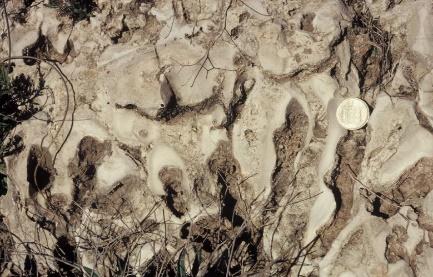
3 TEMPERATE AND TROPICAL CARBONATES CONSTRASTED OTHER MAJOR DIFFERENCES Micrite is neither chemically or biochemically precipitated in temperate-carbonate environments. If present, it forms as result of bioclast grinding Early sea-floor lithification is a significant feature in tropical carbonates but is almost absence in temperate carbonates. As a result temperate-carbonate particles are loose on the sea-floor and can be easily remobilized. In this respect temperate carbonates can be compared with and behave very much like siliciclastic sediments Sedimentation rates are one order of magnitude (ten times) higher in tropical than in temperate carbonates
4 MEDITERRANEAN, NEOGENE SHELF- CARBONATE RECORD Alternating temperate and tropical carbonate episodes are common feature in the Upper Neogene stratigraphic record of the western Mediterranean Temperate carbonates Tropical carbonates Temperate carbonates appear in the early late-tortonian, latest Tortonian-earliest Messinian and in the Pliocene Tropical carbonate formation took place in the earliest Tortonian, late Tortonian and the Messinian

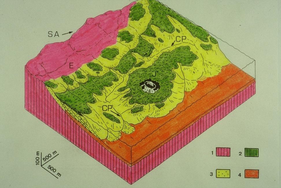
5 A CASE STUDY: THE MEDITERRANEAN-LINKED NEOGENE BASINS OF THE BETIC CORDILLERA These basins, linked to the open Mediterranean sea to the S and to the E, differentiated as small, interconnected marine passages during the Alpine Orogeny in Middle-Late Miocene times Carbonates deposited on siliclastic-free shelf areas at the margins of these basins were of two types: temperate and tropical. Both types contain abundant bioclast remains

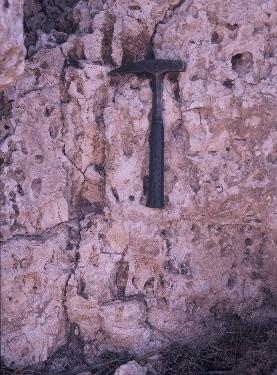
6 THE TEMPERATE CARBONATES These non-reefal, cold-water carbonates formed in similar conditions to those occurring on the Present-day Mediterranean sea, with mean winter, sea-surface water temperature ranging between 14 C and 17 C

7 DEPOSITIONAL MODELS OF TEMPERATE CARBONATES IN THE BETIC CORDILLERA Factory zones THE FACTORY ZONE CONCEPT Carbonate production took place in localized, usually shelthered, relatively low-energy areas


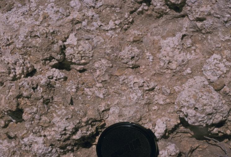
8 SOME REPRESENTATIVE EXAMPLES Oyster factory Pectinid factory FACTORY FACIES Nodular bryozoan factory Branching bryozoan factory Branching coralline factory Nodular coralline factory


9 REDEPOSITED TEMPERATE CARBONATES MOBILIZATION PROCESSES The lack of early lithification favoured mobilization of skeletal particles from the factory Waves and currents accumulated bioclastic particles in shoals, spits and beaches Skeletal grains were mobilized downslope as sediment gravity flows Temperate-carbonate sediments were also mobilized via submarine channels and canyons


10 THE TROPICAL CARBONATES A second type of Mediterranean Neogene carbonate deposits are tropical carbonates, exemplified by coral reefs with abundant hermatypic coral remains. These reefs are strong evidence of the existence of a warm Mediterranean sea at certain times during the Neogene Present-day reefs formed by hermatypic corals only develop in shallow marine environments, with mean winter sea-surface water temperatures of 20 C or higher

11 THE TROPICAL EPISODES THE NEOGENE CORAL REEFS IN THE MEDITERRANEAN-LINKED BASINS


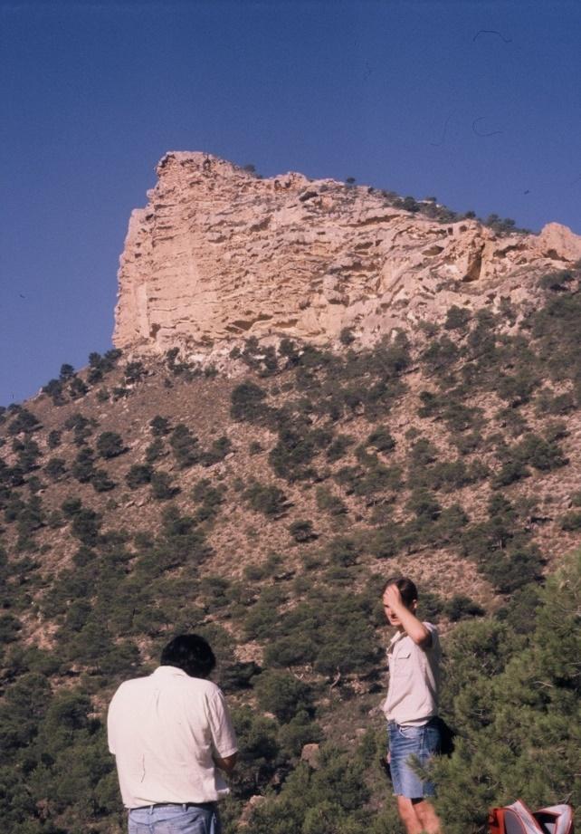
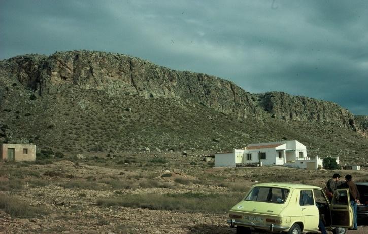
12 Field views THE TORTONIAN REEFS The corals

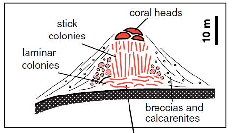
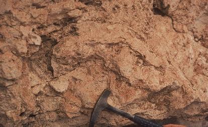
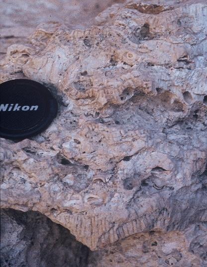
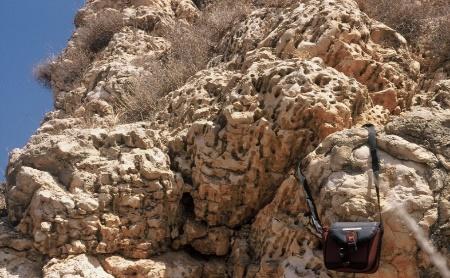
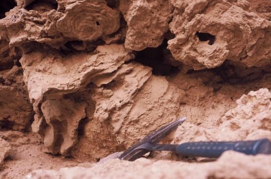
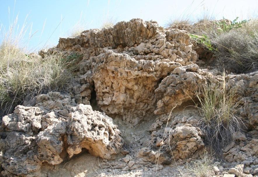
13 THE MESSINIAN REEFS MOUND-LIKE BIOHERMS Coral mound Halimeda mounds Coral mound Coral reef FRINGING REEFS
14 TEMPERATE AND TROPICAL CARBONATE EPISODES IN THE UPPERMOST MIOCENE In the uppermost Miocene, temperate and tropical carbonate episodes follow each other and alternate in time. These alternations can be correlated with the Late Neogene global sea-level curve Temperate carbonates accumulated on ramps during sea-level lowstands of thirdorder, eustatic sea-level cycles. Tropical carbonates formed on shelves during rising and high sea levels All this suggests that the change in the type of carbonate was driven by seawater temperature variations related to global sea-level fluctuations

15 OXYGEN STABLE-ISOTOPE DATA OXYGEN-ISOTOPE DATA CONFIRM THE CLIMATE ALTERNATIONS IN THE UPPERMOST MIOCENE Reef units Orbulina universa Cibicioides dutemplei d 18 O values, together with plankticforaminiferal assemblages, suggest a rise in sea-surface temperatures in the early Messinian as the change from temperate to tropical, reef carbonate deposition took place Temperatecarbonate unit SEA-SURFACE TEMPERATURE IS THE MAJOR FACTOR CONTROLLING CARBONATE TYPE Higher I Lower Mediterranean sea-surface temperatures Cold-water foraminifer Warm-water foraminifera TEMPERATE AND TROPICAL ALTERNATIONS REFLECT CYCLICAL CLIMATE CHANGES, OF PRESUMABLY GLOBAL SIGNIFICANCE, AFFECTING ALL THE WESTERN MEDITERRANEAN AREA
16 ADDITIONAL DATA A cooling of Mediterranean waters at the Tortonian-Messinian boundary has also been detected with the d 18 O record of planktic and benthic foraminifers in the Monte Casino section in Italy (Kouwenhoven et al., 1999*), and in the Salé Briquetiere section in the Rifian Corridor in Morocco (Hodell et al., 1994*) Increase in global ice volume has been invoked as a possible causal mechanism (Hodell et al., 1994*). Ice cap expansion has been reported from the southern hemisphere (Warnke et al., 1992*), and from the northern hemisphere (Thiede et al., 1998*), at about 7 Ma, near the Tortonian- Messinian boundary *Check in reference list of key paper
 belt M: Mediterranean ( warm-temperate ) belt D: Tropical ( Desert ) belt E: Equatorial belt In cold stages polar ice-cap expansion resulted in the displacement of the")
17 THE CLIMATE CHANGES IN THE UPPERMOST MIOCENE THE CLIMATIC-BELT FLUCTUATIONS The diagram exemplifies the Present-day ( cold stage ) situation Key line: the temperate-tropical boundary P: Polar belt T: Temperate ( cold-temperate ) belt M: Mediterranean ( warm-temperate ) belt D: Tropical ( Desert ) belt E: Equatorial belt In cold stages polar ice-cap expansion resulted in the displacement of the temperatetropical boundary to the South. Consequently, the western Mediterranean sea area fell within the temperate climatic belt. In contrast, during warm periods ice caps significantly melted, the tropical belt extended to the North, and the Mediterranean sea area was within the (sub)tropical belt
 deposits accumulated in its deepest")
18 THE LOST, LATE MESSINIAN TEMPERATE-CARBONATE EPISODE During the last Messinian sea-level fall evaporites formed in the Mediterranean sea instead of temperate carbonates In Messinian times, at ~ 5 9 Ma, the Mediterranean sea dried out completely as a consequence of the closing of the Atlantic- Mediterranean connections Huge salt (halite) deposits accumulated in its deepest areas
19 THE PLIOCENE ANOMALY Temperate carbonates formed as well in the western Mediterranean during the Lower Pliocene, even though the global climate was warmer than during the latemost Miocene (Zachos et al., 2001*) *Check in reference list of key paper


20 LOWER PLIOCENE,TEMPERATE-CARBONATE DEPOSITION IN THE WESTERN MEDITERRANEAN During the Early Pliocene the closure of the Rifian Straits and the opening of the Gibraltar Straits induced the flowing of temperate surface waters into the Mediterranean Sea from a more northern, cooler source area, resulting in the deposition of temperate carbonates during a global, warm high-stand stage. Present- day winter surface-water temperatures on the Atlanticside position of the Rifian corridors are about 1.5 C higher than on the western side of the Straits of Gibraltar Early Pliocene situation
21 EARLY PLIOCENE, OXYGEN-ISOTOPE DATA FROM THE WESTERN MEDITERRANEAN Isotopic studies (oxygen stable isotope values), carried out on planktonic foraminifers (Orbulina universa) from a core (Hole 976B) in the western Mediterranean (ODP Leg 161, Site 976), confirm a temperature decrease of Mediterranean surface waters during the Early Pliocene, at about 4.9 Ma
Sierro F.J. 1, Ledesma S. 2 and Flores J.A. 1
 Astrobiochronology of Late Neogene deposits near the Strait of Gibraltar (SW Spain). Implications for the tectonic control of the Messinian Salinity Crisis. Sierro F.J. 1, Ledesma S. 2 and Flores J.A.
Chapter 15 Millennial Oscillations in Climate
 Chapter 15 Millennial Oscillations in Climate This chapter includes millennial oscillations during glaciations, millennial oscillations during the last 8000 years, causes of millennial-scale oscillations,
Outline 23: The Ice Ages-Cenozoic Climatic History
 Outline 23: The Ice Ages-Cenozoic Climatic History Continental Glacier in Antarctica Valley Glaciers in Alaska, note the moraines Valley Glaciers in Alaska, note the moraines Mendenhall Glacier, Juneau,
Climate and Environment
 Climate and Environment Oxygen Isotope Fractionation and Measuring Ancient Temperatures Oxygen Isotope Ratio Cycles Oxygen isotope ratio cycles are cyclical variations in the ratio of the mass of oxygen
lecture 12 Paleoclimate
 lecture 12 Paleoclimate OVERVIEW OF EARTH S CLIMATIC HISTORY Geologic time scales http://www.snowballearth.org/index.html Features of the climate during the Cretaceous period the land-sea distribution
Pleistocene Glaciation (Ch.14) Geologic evidence Milankovitch cycles Glacial climate feedbacks
 Geologic evidence Milankovitch cycles Glacial climate feedbacks") Pleistocene Glaciation (Ch.14) Geologic evidence Milankovitch cycles Glacial climate feedbacks End of last ice-age rise of human civilization Modern ice-ages begin Asteroid impact end of dinosaurs Cambrian
Pleistocene Glaciation (Ch.14) Geologic evidence Milankovitch cycles Glacial climate feedbacks End of last ice-age rise of human civilization Modern ice-ages begin Asteroid impact end of dinosaurs Cambrian
Development of the Global Environment
 Development of the Global Environment G302: Spring 2004 A course focused on exploration of changes in the Earth system through geological history Simon C. Brassell Geological Sciences simon@indiana.edu
Last Time. Submarine Canyons and Fans. Turbidites. MAS 603: Geological Oceanography. Lecture 16: Greenhouse vs. Icehouse Earths
 UNIVERSITY OF SOUTH ALABAMA Last Time MAS 603: Geological Oceanography Lecture 16: Greenhouse vs. Icehouse Earths Submarine Fans Definition and morphology Transport mechanisms (density currents) Submarine
Lecture 18 Paleoceanography 2
 Lecture 18 Paleoceanography 2 May 26, 2010 Trend and Events Climatic evolution in Tertiary Overall drop of sea level General cooling (Figure 9-11) High latitude (deep-water) feature Two major step Middle
Paleoclimate indicators
 Paleoclimate indicators Rock types as indicators of climate Accumulation of significant thicknesses of limestone and reef-bearing limestone is restricted to ~20º + - equator Gowganda tillite, Ontario
The Nature of Sedimentary Rocks
 The Nature of Sedimentary Rocks Sedimentary rocks are composed of: Fragments of other rocks Chemical precipitates Organic matter or biochemically produced materials The Nature of Sedimentary Rocks Sedimentary
Lecture 3 questions Temperature, Salinity, Density and Circulation
 Lecture 3 questions Temperature, Salinity, Density and Circulation (1) These are profiles of mean ocean temperature with depth at various locations in the ocean which in the following (a, b, c) figures
The surface of the ocean floor is as varied as the land. The five major oceans, from largest to smallest, are
 11.1 Ocean Basins The surface of the ocean floor is as varied as the land. The five major oceans, from largest to smallest, are w the Pacific w the Atlantic w the Indian w the Southern w the Arctic The
Ordovician. System. Cambrian. System
 443 495 543 Late Middle Early Late Middle Early Ordovician System Cambrian System Earth History, Ch. 13 1 Ch. 13 Review: Early Paleozoic life & Burgess Shale fauna Most animal phyla originated in Cambrian;
Lecture Outline Wednesday - Friday February 14-16, 2018
 Lecture Outline Wednesday - Friday February 14-16, 2018 Quiz 2 scheduled for Friday Feb 23 (Interlude B, Chapters 6,7) Questions? Chapter 6 Pages of the Past: Sedimentary Rocks Key Points for today Be
Arthur Saller 1. Search and Discovery Article #51393 (2017)** Posted June 26, Abstract
** Posted June 26, Abstract") PS Mixed Carbonates and Siliciclastics North of the Mahakam Delta, Offshore East Kalimantan, Indonesia* Arthur Saller 1 Search and Discovery Article #51393 (2017)** Posted June 26, 2017 *Adapted from poster
PS Mixed Carbonates and Siliciclastics North of the Mahakam Delta, Offshore East Kalimantan, Indonesia* Arthur Saller 1 Search and Discovery Article #51393 (2017)** Posted June 26, 2017 *Adapted from poster
A brief history of the Messinian on Sicily
 A brief history of the Messinian on Sicily Rob Butler The Salinity Crisis in the Mediterranean represents one of the most dramatic examples environmental change outside of glaciated areas in the relatively
Where is all the water?
 Where is all the water? The distribution of water at the Earth's surface % of total Oceans 97.25 Ice caps and glaciers 2.05 Groundwater 0.68 Lakes 0.01 Soils 0.005 Atmosphere (as vapour) 0.001 Rivers 0.0001
Module 11: Meteorology Topic 3 Content: Climate Zones Notes
 Introduction Latitude is such an important climate factor that you can make generalizations about a location's climate based on its latitude. Areas near the equator or the low latitudes are generally hot
The Sorbas Basin. Geological Features
 The Basin Geological Features desplegable INGLES OK copia.qxp 27/5/08 01:43 Página 1 Geological Features and Evolution STRATIGRAPHY OF THE SORBAS BASIN Geological Features and Evolution GEOLOGICAL MAP
Lab 7: Sedimentary Structures
 Name: Lab 7: Sedimentary Structures Sedimentary rocks account for a negligibly small fraction of Earth s mass, yet they are commonly encountered because the processes that form them are ubiquitous in the
Directed Reading. Section: Ocean Currents. a(n). FACTORS THAT AFFECT SURFACE CURRENTS
. FACTORS THAT AFFECT SURFACE CURRENTS") Skills Worksheet Directed Reading Section: Ocean Currents 1 A horizontal movement of water in a well-defined pattern is called a(n) 2 What are two ways that oceanographers identify ocean currents? 3 What
Skills Worksheet Directed Reading Section: Ocean Currents 1 A horizontal movement of water in a well-defined pattern is called a(n) 2 What are two ways that oceanographers identify ocean currents? 3 What
Small area of the ocean that is partially surrounded by land. The Ocean Basins. Three Major Oceans. Three Major Oceans. What is a SEA?
 The Ocean Basins How Deep is the Ocean? 1 2 Three Major Oceans Three Major Oceans Pacific Atlantic the shallowest ocean (3.3km average depth) Indian second shallowest ocean (3.8km average depth) Pacific
Reading Material. See class website. Sediments, from Oceanography M.G. Gross, Prentice-Hall
 Reading Material See class website Sediments, from Oceanography M.G. Gross, Prentice-Hall Materials filling ocean basins Dissolved chemicals especially from rivers and mid-ocean ridges (volcanic eruptions)
A Broecker Brief Origin of the Atlantic s glacial age lower deep water
 A Broecker Brief Origin of the Atlantic s glacial age lower deep water Today s deep Atlantic shows no hint of nutrient stratification (see Figure 1). By contrast, during the last glacial maximum (LGM),
14.2 Ocean Floor Features Mapping the Ocean Floor
 14.2 Ocean Floor Features Mapping the Ocean Floor The ocean floor regions are the continental margins, the ocean basin floor, and the mid-ocean ridge. 14.2 Ocean Floor Features Continental Margins A continental
UNIT 5: ECOLOGY Chapter 15: The Biosphere
 CORNELL NOTES Directions: You must create a minimum of 5 questions in this column per page (average). Use these to study your notes and prepare for tests and quizzes. Notes will be stamped after each assigned
Weather & Ocean Currents
 Weather & Ocean Currents Earth is heated unevenly Causes: Earth is round Earth is tilted on an axis Earth s orbit is eliptical Effects: Convection = vertical circular currents caused by temperature differences
Paleoceanography II Telluric Effects on Oceanography
 Paleoceanography II Telluric Effects on Oceanography Geological Oceanography OCN 622 Gary McMurtry Telluric Effects Tellus = Earth Distribution of Continents at 100 Ma BP and Present Comparison of Earth
EGAS. Ministry of Petroleum
 EGAS Ministry of Petroleum EGAS Ministry of Petroleum About The Block Location: N. Thekah offshore block is located at about 56 km to the north of the Mediterranean shore line, 85 km to the north west
The Late Tertiary Deep-Water Siliciclastic System of the Levant Margin - An Emerging Play Offshore Israel*
 The Late Tertiary Deep-Water Siliciclastic System of the Levant Margin - An Emerging Play Offshore Israel* Michael A. Gardosh 1, Yehezkel Druckman 2 and Binyamin Buchbinder 2 Search and Discovery Article
6. What has been the most effective erosive agent in the climate system? a. Water b. Ice c. Wind
 Multiple Choice. 1. Heinrich Events a. Show increased abundance of warm-water species of planktic foraminifera b. Show greater intensity since the last deglaciation c. Show increased accumulation of ice-rafted
UNIT 4 SEDIMENTARY ROCKS
 UNIT 4 SEDIMENTARY ROCKS WHAT ARE SEDIMENTS Sediments are loose Earth materials (unconsolidated materials) such as sand which are transported by the action of water, wind, glacial ice and gravity. These
Mission au Maroc. There and Back Again. Ruža Ivanović & Rachel Flecker
 Mission au Maroc or There and Back Again Ruža Ivanović & Rachel Flecker SPAIN 4 0 36 36 Messâdit Loulja A Ain el Beida Oued Akrech Zobzit 4 MOROCCO 0 How to... Lab-field-lab Target samples on paper
Chapter 15. The Late Paleozoic World
 Chapter 15 The Late Paleozoic World Guiding Questions How did marine life of late Paleozoic time differ from that of middle Paleozoic time? How did terrestrial floras change on a global scale in late Paleozoic
Environmental changes
 Environmental changes What are the fishery, environmental, and trophic effects in historical data? Can we use short-term predictions from multiple regression models? Two kind of predictions: What happens
The Ocean Floor Chapter 14. Essentials of Geology, 8e. Stan Hatfield and Ken Pinzke Southwestern Illinois College
 The Ocean Floor Chapter 14 Essentials of Geology, 8e Stan Hatfield and Ken Pinzke Southwestern Illinois College The vast world ocean Earth is often referred to as the water planet 71% of Earth s surface
Lecture 21: Glaciers and Paleoclimate Read: Chapter 15 Homework due Thursday Nov. 12. What we ll learn today:! Learning Objectives (LO)
") Learning Objectives (LO) Lecture 21: Glaciers and Paleoclimate Read: Chapter 15 Homework due Thursday Nov. 12 What we ll learn today:! 1. 1. Glaciers and where they occur! 2. 2. Compare depositional and
Learning Objectives (LO) Lecture 21: Glaciers and Paleoclimate Read: Chapter 15 Homework due Thursday Nov. 12 What we ll learn today:! 1. 1. Glaciers and where they occur! 2. 2. Compare depositional and
Glaciers and Ice Ages
 ES 106 Glaciers and Ice Ages I. Glacier thick mass of ice accumulated over years, decades, centuries A. Function of recrystallization of fallen snow B. Types 1. alpine valley: a. high elevations worldwide
Tracers. 1. Conservative tracers. 2. Non-conservative tracers. Temperature, salinity, SiO 2, Nd, 18 O. dissolved oxygen, phosphate, nitrate
 Tracers 1. Conservative tracers Temperature, salinity, SiO 2, Nd, 18 O 2. Non-conservative tracers dissolved oxygen, phosphate, nitrate Temperature itself is a tracer but other tracers (like oxygen isotopes)
CORRELATION OF CLIMATIC AND SOLAR VARIATIONS OVER THE PAST 500 YEARS AND PREDICTING GLOBAL CLIMATE CHANGES FROM RECURRING CLIMATE CYCLES
 Easterbrook, D.J., 2008, Correlation of climatic and solar variations over the past 500 years and predicting global climate changes from recurring climate cycles: International Geological Congress, Oslo,
Almost of Earth is covered by water. On a map, the continents appear as huge islands surrounded by a vast global ocean.
 Earth s Oceans & Ocean Floor Date: Feelin Blue What are Earth s five main oceans? Almost of Earth is covered by water. On a map, the continents appear as huge islands surrounded by a vast global ocean.
Accuracy of dating methods utilised
 Dating Methods Homke et al. (2009) measured and dated more than 1500 m of stratigraphy in the Amiran anticline, and emphasised the need for multiple dating methods given the lithologic and sedimentary
1. Introduction 2. Ocean circulation a) Temperature, salinity, density b) Thermohaline circulation c) Wind-driven surface currents d) Circulation and
 Temperature, salinity, density b) Thermohaline circulation c) Wind-driven surface currents d) Circulation and") 1. Introduction 2. Ocean circulation a) Temperature, salinity, density b) Thermohaline circulation c) Wind-driven surface currents d) Circulation and climate change e) Oceanic water residence times 3.
1. Introduction 2. Ocean circulation a) Temperature, salinity, density b) Thermohaline circulation c) Wind-driven surface currents d) Circulation and climate change e) Oceanic water residence times 3.
Ocean Circulation. In partnership with Dr. Zafer Top
 Ocean Circulation In partnership with Dr. Zafer Top Samantha Hampton Honors Science December 15, 2014 Ocean Circulation is the large scale movement of waters in the ocean basins. Dr. Zafer Top studies
Winds and Global Circulation
 Winds and Global Circulation Atmospheric Pressure Winds Global Wind and Pressure Patterns Oceans and Ocean Currents El Nino How is Energy Transported to its escape zones? Both atmospheric and ocean transport
Glaciers form wherever snow and ice can accumulate High latitudes High mountains at low latitudes Ice temperatures vary among glaciers Warm
 The Cryosphere Glaciers form wherever snow and ice can accumulate High latitudes High mountains at low latitudes Ice temperatures vary among glaciers Warm (temperate) glaciers: at pressure melting point,
Chapter 7 Benthic deep-sea carbonates: reefs and seeps
 Chapter 7 Benthic deep-sea carbonates: reefs and seeps Carbonates are formed across most latitudes and they are not restricted to shallow water but are also found in all but the deepest abyssal and hadal
Foundations of Earth Science, 6e Lutgens, Tarbuck, & Tasa
 Foundations of Earth Science, 6e Lutgens, Tarbuck, & Tasa Oceans: The Last Frontier Foundations, 6e - Chapter 9 Stan Hatfield Southwestern Illinois College The vast world ocean Earth is often referred
Global climate change
 Global climate change What is climate change? This winter was really cold! Temp difference ( C): Jan 2004 vs. Jan 2002-2003 Make your own maps at: http://www.giss.nasa.gov/data/update/gistemp/maps/ 1 What
MAR 110 LECTURE #10 The Oceanic Conveyor Belt Oceanic Thermohaline Circulation
 1 MAR 110 LECTURE #10 The Oceanic Conveyor Belt Oceanic Thermohaline Circulation Ocean Climate Temperature Zones The pattern of approximately parallel oceanic surface isotherms (lines of constant temperature)
ATOC OUR CHANGING ENVIRONMENT
 ATOC 1060-002 OUR CHANGING ENVIRONMENT Class 22 (Chp 15, Chp 14 Pages 288-290) Objectives of Today s Class Chp 15 Global Warming, Part 1: Recent and Future Climate: Recent climate: The Holocene Climate
EGAS. Ministry of Petroleum
 EGAS Ministry of Petroleum EGAS Ministry of Petroleum About The Block Location: N. El Arish offshore block is located in the extreme eastern part of the Egypt s economic water border and bounded from the
Oceanography is the scientific study of oceans Oceans make up over 70% of the Earth s surface
 Oceanography Oceanography is the scientific study of oceans Oceans make up over 70% of the Earth s surface An ocean must be large and have features which set it apart from other oceans (currents, water
6th Grade Science Sample Assessment Items S6E3c.
 Composition 6th Grade Science Sample Assessment Items Ocean water differs from freshwater in that it has. A. a lower temperature B. a higher temperature C. a higher concentration of silicon dioxide D.
SUPPLEMENTARY INFORMATION
 SUPPLEMENTARY INFORMATION DOI: 1.138/NGEO168 "Strength and geometry of the glacial Atlantic Meridional Overturning Circulation" S2 Map of core locations Core locations of the Holocene and LGM 231 / 23
Rapid Climate Change: Heinrich/Bolling- Allerod Events and the Thermohaline Circulation. By: Andy Lesage April 13, 2010 Atmos.
 Rapid Climate Change: Heinrich/Bolling- Allerod Events and the Thermohaline Circulation By: Andy Lesage April 13, 2010 Atmos. 6030 Outline Background Heinrich Event I/Bolling-Allerod Transition (Liu et
Engineering Geology ECIV 2204
 Engineering Geology ECIV 2204 Instructor : Dr. Jehad Hamad 2017-2016 Chapter (6) : Sedimentary Rocks Chapter 6: Sedimentary Rocks Chapter 6: Sedimentary Rocks Origin and nature of sedimentary rocks: Sedimentary
Tropical Pacific responses to Neogene Andean uplift and highlatitude. Ran Feng and Chris Poulsen University of Michigan
 Tropical Pacific responses to Neogene Andean uplift and highlatitude sea ice expansion Ran Feng and Chris Poulsen University of Michigan Reconstructions of Neogene equatorial Pacific SSTs SST difference
The boundary between two formations (or any distinct layers) is called a contact. Sedimentary rocks cover 75% of continents.
 is called a contact. Sedimentary rocks cover 75% of continents.") Sedimentary Rocks Sedimentary rocks form at the Earth s surface through interactions of the hydrologic system and the crust. Fortunately, many of these processes are in operation today, and geologists
Sedimentary Rocks Sedimentary rocks form at the Earth s surface through interactions of the hydrologic system and the crust. Fortunately, many of these processes are in operation today, and geologists
Longitude (E) Depth (m)
 Depth (m)") Table 1. Leg 194 proposed sites. Site Priority Line CDP Fig. Latitude (S) Longitude (E) Water Sediment Target Requested PPSP Depth (m) Thickness (m) Depth (m) Penetration (m) Approval CS-01A 1 MAR-29 4486
Table 1. Leg 194 proposed sites. Site Priority Line CDP Fig. Latitude (S) Longitude (E) Water Sediment Target Requested PPSP Depth (m) Thickness (m) Depth (m) Penetration (m) Approval CS-01A 1 MAR-29 4486
PLATE TECTONICS THEORY
 PLATE TECTONICS THEORY Continental drift Sea floor spreading CONTINENTAL DRIFT CONTINENTAL DRIFT 1. The fitness of continents and Continental Reconstruction Earth ~200 million years ago 1.1 Geometrical
Oceans I Notes. Oceanography
 Oceans I Notes Outlines on the front table Oceanography the science of our oceans that mixes biology, geology, chemistry, and physics (among other sciences) to unravel the mysteries of our seas. Divisions
Marine Ecoregions. Marine Ecoregions. Slide 1. Robert G. Bailey. USDA Forest Service Rocky Mountain Research Station
 Slide 1 Marine Ecoregions Robert G. Bailey Marine Ecoregions Robert G. Bailey USDA Forest Service Rocky Mountain Research Station rgbailey@fs.fed.us Draft of 7/20/2006 8:44 PM Abstract: Oceans occupy some
Beckenanalyse 2. Genetische stratigraphische Konzepte
 Beckenanalyse 2. Genetische stratigraphische Konzepte Einsele 2000 CYCLIC BEDDING Einsele 2000 1 Sequenzstratigraphie Das Konzept der Sequenzstratigraphie beruht auf dem Zusammenspiel von Sedimentzufuhr
The North Atlantic Oscillation: Climatic Significance and Environmental Impact
 1 The North Atlantic Oscillation: Climatic Significance and Environmental Impact James W. Hurrell National Center for Atmospheric Research Climate and Global Dynamics Division, Climate Analysis Section
- 5 - Figure 2. A. Location map for the Cibao Valley, northern Dominican Republic with generalized geology and major features (Erikson et al., 1998).
.") Diana Ortega-Ariza is a PhD student at the University of Kansas. Her dissertation work proposes to develop absolute age-constrained sequence stratigraphic frameworks and construct rock-based quantitative
Diana Ortega-Ariza is a PhD student at the University of Kansas. Her dissertation work proposes to develop absolute age-constrained sequence stratigraphic frameworks and construct rock-based quantitative
Patterns and average rates of late Neogene Recent uplift of the Betic Cordillera, SE Spain
 Geomorphology 50 (2003) 3 26 www.elsevier.com/locate/geomorph Patterns and average rates of late Neogene Recent uplift of the Betic Cordillera, SE Spain Juan C. Braga a, *, José M. Martín a, Cecilio Quesada
Earth s Climate Patterns
 Earth s Climate Patterns Reading: Chapter 17, GSF 10/2/09 Also Jackson (linked on course web site) 1 What aspects of climate affect plant distributions? Climate: long-term distribution of weather in an
Climate Change. Unit 3
 Climate Change Unit 3 Aims Is global warming a recent short term phenomenon or should it be seen as part of long term climate change? What evidence is there of long-, medium-, and short- term climate change?
Quiz 12 Bonus 2 (9:30-9:35 AM)
") Quiz 12 Bonus 2 (9:30-9:35 AM) UNIVERSITY OF SOUTH ALABAMA GY 112: Earth History Lectures 32 and 33: Mesozoic Sedimentation Instructor: Dr. Douglas W. Haywick Last Time Mesozoic Tectonics A) The Triassic
Quiz 12 Bonus 2 (9:30-9:35 AM) UNIVERSITY OF SOUTH ALABAMA GY 112: Earth History Lectures 32 and 33: Mesozoic Sedimentation Instructor: Dr. Douglas W. Haywick Last Time Mesozoic Tectonics A) The Triassic
Ch. 17 Review. Life in the Cretaceous
 Ch. 17 Review Life in the Cretaceous Diversification of diatoms, planktonic forams, calcareous nannoplankton Diversification of mobile predators (especially mollusks and teleost fishes) Origin of the angiosperms
Actual bathymetry (with vertical exaggeration) Geometry of the ocean 1/17/2018. Patterns and observations? Patterns and observations?
 Geometry of the ocean 1/17/2018. Patterns and observations? Patterns and observations?") Patterns and observations? Patterns and observations? Observations? Patterns? Observations? Patterns? Geometry of the ocean Actual bathymetry (with vertical exaggeration) Continental Continental Basin
Patterns and observations? Patterns and observations? Observations? Patterns? Observations? Patterns? Geometry of the ocean Actual bathymetry (with vertical exaggeration) Continental Continental Basin
1. Oceans. Example 2. oxygen.
 1. Oceans a) Basic facts: There are five oceans on earth, making up about 72% of the planet s surface and holding 97% of the hydrosphere. Oceans supply the planet with most of its oxygen, play a vital
GY 402: Sedimentary Petrology
 UNIVERSITY OF SOUTH ALABAMA GY 402: Sedimentary Petrology Lecture 22: Reefs Instructor: Dr. Douglas W. Haywick Last Time Shelves Definition and a bit of history Factors controlling shelf sedimentation
Today we will discuss global climate: how it has changed in the past, and how the current status and possible future look.
 Global Climate Change Today we will discuss global climate: how it has changed in the past, and how the current status and possible future look. If you live in an area such as the Mississippi delta (pictured)
Mediterranean Climates (Csa, Csb)
") Climatic Zones & Types Part II I've lived in good climate, and it bores the hell out of me. I like weather rather than climate. 1 John Steinbeck Mediterranean Climates (Csa, Csb) Main locations Western
Climatic Zones & Types Part II I've lived in good climate, and it bores the hell out of me. I like weather rather than climate. 1 John Steinbeck Mediterranean Climates (Csa, Csb) Main locations Western
/ Past and Present Climate
 MIT OpenCourseWare http://ocw.mit.edu 12.842 / 12.301 Past and Present Climate Fall 2008 For information about citing these materials or our Terms of Use, visit: http://ocw.mit.edu/terms. Ice Sheet Paleoclimatology
8. Climate changes Short-term regional variations
 8. Climate changes 8.1. Short-term regional variations By short-term climate changes, we refer here to changes occurring over years to decades. Over this timescale, climate is influenced by interactions
COOLING DRYING 19 4 CT WT CT AR. mean global temperature levels of aridity latitudinal stratification have all changed appreciably
 as we have seen. BIOMES are the biota's adaptive response to earth's climate zones but climate too has a history - - it has evolved through time mean global temperature levels of aridity latitudinal stratification
Chp Spectral analysis a. Requires that the climate record must be at least 4 times longer than the cycled analyzed
 Chp 7 1. Earth s seasons are caused by a. The movement of the Sun from North to South of the equator and back again over a year s time b. The distance between Earth and the Sun c. The rate of Earth s movement
CHAPTER 6 & 7 VOCABULARY
 CHAPTER 6 & 7 VOCABULARY 1. Biome 2. Climate 3. Latitude 4. Altitude 5. Emergent layer 6. Epiphyte 7. Understory 8. Permafrost 9. Wetland 10.Plankton 11.Nekton 12.Benthos 13.Littoral zone 14.Benthic zone
MARINE GEOLOGY & GEOGRAPHY
 MARINE GEOLOGY & GEOGRAPHY Bathymetry BATHYMETRY BATHYMETRY THE UNDERWATER EQUIVALENT TO TOPOGRAPHY THE STUDY OF WATER DEPTH A BATHYMETRIC MAP SHOWS FLOOR RELIEF OR TERRAIN AS CONTOUR LINES Bathymetry
Chapter outline. Reference 12/13/2016
 Chapter 2. observation CC EST 5103 Climate Change Science Rezaul Karim Environmental Science & Technology Jessore University of science & Technology Chapter outline Temperature in the instrumental record
Florida s Changing Shape
 Florida s Changing Shape Background: For much of its history, Florida was underwater. At first, Florida consisted solely of the Florida Platform, a limestone base formed from the calcium carbonate remains
ATOC 5051 INTRODUCTION TO PHYSICAL OCEANOGRAPHY. Lecture 2
 ATOC 5051 INTRODUCTION TO PHYSICAL OCEANOGRAPHY Lecture 2 Ocean basins and relation to climate Learning objectives: (1)What are the similarities and differences among different ocean basins? (2) How does
Holocene Carbonate-Siliciclastic Shoreline and Ravinement Stratigraphy of the Belize Lagoon: a Mixed-System Model
 Holocene CarbonateSiliciclastic Shoreline and Ravinement Stratigraphy of the Belize Lagoon: a MixedSystem Model DONALD F. MCNEILL AND CLINTON A. COWAN Key findings o Mixedsystem facies heterogeneity during
Sedimentary Rocks. Origin, Properties and Identification. Physical Geology GEOL 101 Lab Ray Rector - Instructor
 Sedimentary Rocks Origin, Properties and Identification Physical Geology GEOL 101 Lab Ray Rector - Instructor Sedimentary Rock Origin and Identification Lab Pre-Lab Internet Link Resources 1) http://www.rockhounds.com/rockshop/rockkey/index.html
Why study forams? Wanted: Dead and Well-Preserved... Mohawk Guy and his Band of Neogene Planktic Foraminifer Friends
 Wanted: Dead and Well-Preserved... Mohawk Guy and his Band of Neogene Planktic Foraminifer Friends Why study forams? Summary Foraminifera are single-celled protists. They are not plants or animals, yet
1 Earth s Oceans. TAKE A LOOK 2. Identify What are the five main oceans?
 CHAPTER 13 1 Earth s Oceans SECTION Exploring the Oceans BEFORE YOU READ After you read this section, you should be able to answer these questions: What affects the salinity of ocean water? What affects
Air sea temperature decoupling in western Europe during the last interglacial glacial transition
 María Fernanda Sánchez Goñi, Edouard Bard, Amaelle Landais, Linda Rossignol, Francesco d Errico SUPPLEMENTARY INFORMATION DOI: 10.1038/NGEO1924 Air sea temperature decoupling in western Europe during the
Understanding Earth Fifth Edition
 Understanding Earth Fifth Edition Grotzinger Jordan Press Siever Chapter 5: SEDIMENTATION: Rocks Formed by Surface Processes Lecturer: H Mohammadzadeh Assistant professors, Department of Geology, FUM Copyright
IODP Proposal Cover Sheet 914 -
 IODP Proposal Cover Sheet 914 - Full Brazilian Equatorial Margin Paleoceanography Received for: 2017-04-03 Title Cenozoic Paleoceanography of the Brazilian Equatorial Margin (PBEM) Proponents Luigi Jovane,
SEDIMENTARY PHOSPHORITES: GENESIS, FACIES AND OCCURRENCE. Peter Berger Samantha Dwyer Jessica Hellwig Eric Obrock Kristin Read
 SEDIMENTARY PHOSPHORITES: GENESIS, FACIES AND OCCURRENCE Peter Berger Samantha Dwyer Jessica Hellwig Eric Obrock Kristin Read Introduction Phosphogenesis & Deposystems Facies Case Studies: Western U.S.,
b) occurs before the anvil shape at the top of the cloud has formed. c) is marked by an absence of significant downdrafts.
 occurs before the anvil shape at the top of the cloud has formed. c) is marked by an absence of significant downdrafts.") Thunderstorms Question 1 The only requirement for a thunderstorm is: a) sinking air. b) upper level convergence. c) still air. d) rising air. Question 2 The mature stage of air-mass thunderstorms: a) is
Thunderstorms Question 1 The only requirement for a thunderstorm is: a) sinking air. b) upper level convergence. c) still air. d) rising air. Question 2 The mature stage of air-mass thunderstorms: a) is
Sediment and sedimentary rocks Sediment
 Sediment and sedimentary rocks Sediment From sediments to sedimentary rocks (transportation, deposition, preservation and lithification) Types of sedimentary rocks (clastic, chemical and organic) Sedimentary
Question: What is the primary reason for the great abundance of fish along the Peruvian coast?
 Buzzer Question # 1 Question Type: toss-up Question Format: Multiple Choice Category: Biology What is the primary reason for the great abundance of fish along the Peruvian coast? Answer W: upwelling Answer
Environmental Science
 Environmental Science A Study of Interrelationships Cui Jiansheng Hebei University of Science and Technology CH06 Kinds of Ecosystems and Communities Chapter Objectives After reading this chapter, you
4. In areas where tectonic plates collide, the seafloor has deep. 5. In areas where tectonic plates separate, the seafloor has mid- ocean
 Name Date Hour Table Chapter 14 Lesson One- General Directions: Use the word bank below to complete each statement. NOT all terms are used. abyssal plains brackish water condensation energy freshwater
Map Elements & The 5 Oceans
 Map Elements & The 5 Oceans Latitude and Longitude Longitude lines run north and south. Latitude lines run east and west. The lines measure distances in degrees. Latitude Longitude Where is 0 degrees?