Role of the structural inheritance of the oceanic lithosphere in the magmato-tectonic evolution of Piton de la Fournaise volcano (La Réunion Island)
|
|
|
- Arline Allen
- 6 years ago
- Views:
Transcription
1 Click Here for Full Article JOURNAL OF GEOPHYSICAL RESEARCH, VOL. 112,, doi: /2006jb004598, 2007 Role of the structural inheritance of the oceanic lithosphere in the magmato-tectonic evolution of Piton de la Fournaise volcano (La Réunion Island) Laurent Michon, 1 Francky Saint-Ange, 1 Patrick Bachelery, 1 Nicolas Villeneuve, 2 and Thomas Staudacher 3 Received 26 June 2006; revised 10 October 2006; accepted 3 November 2006; published 24 April [1] La Réunion Island is located east of Madagascar, on the eastern rim of the tectonically inactive Mascarene Basin. This island is composed of three shield volcanoes of which only Piton de la Fournaise is currently active. Although the magmatic activity is restricted to Piton de la Fournaise, a scattered seismicity occurs on the whole 200 km wide volcanic edifice and in the underlying oceanic crust. We carried out a multiscale analysis to understand (1) the origin of the seismicity in the geodynamic context and (2) the role of the oceanic lithosphere in the deformation of Piton de la Fournaise and La Réunion Island. Analysis of the magmatic system suggests that the magma ascent is controlled by large N25 30 and N fracture zones located below the Enclos depression. We also show that the orientation difference between the eruptive fissures and the related dykes result from a rotation of the main principal stress s 1 from vertical to downslope through the surface. Combining a Digital Elevation Model (DEM) analysis, field observations and the geophysical data reveals that the volcano is affected by large fault zones. The fault distribution indicates the predominance of a main N70 80 trend. Magnetic data show the same N80 orientation characterizing the remnant part of the Alizés volcano. Such parallel alignment suggests a control exerted by the underlying Alizés volcano on Piton de la Fournaise. Furthermore, the alignment between the crustal orientations and the structures determined on the island suggests a control of the crustal structures in La Réunion s volcano-tectonic activity. Contrary to several volcanic islands such as Hawaii and Tenerife, La Réunion volcanoes lie on an upbending crust. Then, we interpret the reactivation of the crustal faults as resulting from a crustal uplift related to the thermal erosion of the base of the lithosphere and/or to strong underplating. The upward deformation may prevent the spreading of the volcanoes, as no evidence of such a mechanism is observed in the bathymetry and the seismic data around the island. Citation: Michon, L., F. Saint-Ange, P. Bachelery, N. Villeneuve, and T. Staudacher (2007), Role of the structural inheritance of the oceanic lithosphere in the magmato-tectonic evolution of Piton de la Fournaise volcano (La Réunion Island), J. Geophys. Res., 112,, doi: /2006jb Introduction [2] The building of an oceanic island is mainly induced by the development of a mantle plume at depth and its upwelling below the oceanic lithosphere [Morgan, 1971]. The volcanic activity resulting from the ascent of this mantle anomaly is frequently radially distributed around a volcanic center and concentrated in volcanic rift zones 1 Laboratoire des Sciences de la Terre de l Université delaréunion (LSTUR), Institut de Physique du Globe de Paris, CNRS, Saint Denis, France. 2 CREGUR, Université delaréunion, Saint Denis, France. 3 Observatoire volcanologique du Piton de la Fournaise (OVPF), Institut de Physique du Globe de Paris, CNRS, La Plaine des Cafres, France. Copyright 2007 by the American Geophysical Union /07/2006JB004598$09.00 [e.g., Walker, 1999]. As documented for the Hawaiian volcanoes [MacDonald and Abbott, 1970] and the Society and Austral Islands [Binard et al., 1991], the orientation of these rift zones is superimposed to main crustal orientations as transform zones and/or paleoridges. Active faulting is frequently associated with the volcanism. Fault analysis reveals that (1) normal faulting always prevails whatever the geodynamic context is and (2) faults and dyke swarms (i.e., rift zones) are parallel [MacDonald and Abbott, 1970; Marinoni and Gudmundsson, 2000]. As mentioned by Binard et al. [1991], such an alignment between tectonics and volcanism, and the rift zones and the crustal structures, respectively, suggests a control of the oceanic lithosphere on the deformation of shield volcanoes and on the location of the magmatism. [3] La Réunion Island is located east of Madagascar and is related to the mantle plume that generated the Deccan 1of21
2 Traps at the Cretaceous-Tertiary boundary [Courtillot et al., 1986; O Neill et al., 2003]. The island built up on an oceanic lithosphere characterized by N30 40 transform zones, predominant N trending magnetic anomalies [e.g., Fretzdorff et al., 1998], and local N80 magnetic anomalies east of La Réunion (Figure 1a) [Lénat et al., 2001]. The N orientation also corresponds to the overall elongation of the island, which results from the emplacement of three volcanoes along this axis (the Alizés, Piton des Neiges, and Piton de la Fournaise volcanoes; Figure 1b [Lénat et al., 2001]). Contrary to Hawaiian volcanoes no active faults were identified at Piton des Neiges and Piton de la Fournaise, suggesting no or undetectable tectonic activity. However, the seismic monitoring carried out by the Piton de la Fournaise Volcano Observatory recorded numerous earthquakes originating in the crust below the island and its vicinity (Figure 2). More distant (100 km) earthquakes, which cannot be precisely located with the current seismic network, occur below the submarine flanks of the edifice. Although the occurrence of earthquakes indicates an active tectonic regime, its origin and consequences in the development of the volcano are poorly understood. [4] Using a multiscale and multidisciplinary analysis, we aim at studying the tectonic activity of La Réunion, integrating it at a lithospheric scale, and understanding the origin of the deformation, taking into account the regional geodynamics and the role of the mantle plume. We focus our work on four different scales: (1) the active magmatic system of PdF, (2) the overall edifice of PdF, (3) the island and the proximal submarine flanks, and (4) the oceanic crust in the island s vicinity. The magmatic system is studied through the analysis of the eruptive fissure and dyke distribution in the Enclos caldera. The tectonic structures of PdF are inferred from a combination of surface deformation derived from a 25 m resolution digital elevation model (DEM), available geophysical data such as seismic, self-potential, magnetic, and audiomagnetotelluric data, field observations, and aerial photographs. As the dense tropical vegetation makes most of the volcanic flanks inaccessible, the field observations are focused on the deep valleys which incise the volcano s western part. Structures of the southern and northern flanks are studied with the DEM and the available geophysical data. At the island scale, a 100 m resolution DEM, gravimetric and magnetic data and sonar images are used to determine the first order subaerial and submarine structures. Finally, the magnetic crustal structures and the oceanic floor topography are integrated in our study to extend the analysis from a kilometer scale to a several hundred kilometers scale. 2. Geological Setting [5] La Réunion Island is the subaerial part of a 7 km high oceanic shield volcano with a diameter of km. Considering the historical magma production rate and the oldest dated subaerial basalts (2Ma[MacDougall, 1971]), an age of around 5 Ma was estimated for the beginning of the edifice growth [Gillot et al., 1994]. The initial evolution was characterized by the development of two adjacent volcanoes (Piton des Neiges and Alizés volcanoes), which encountered recurrent flank destabilizations [Lénat et al., 2001; Bachèlery et al., 2003; Oehler et al., 2004]. Around 530 ka ago, Piton de la Fournaise appeared west of the Alizés volcano which stopped its activity. Between 530 ka and 12 ka (date of the last eruption of Piton des Neiges (PdN) [Deniel et al., 1992]) PdN and PdF showed contemporaneous activity. Finally, since 12 ka, eruptions are restricted to PdF. [6] This multiphase evolution made the structure of the overall edifice of La Réunion very complex. The Alizés volcano is now completely dismantled and the only evidence of its past existence is (1) a large intrusion complex identified by drilling below the Grand Brûlé (Figure 3) [Rançon et al., 1989], (2) the remnant old submarine relieves [Labazuy, 1996], and (3) the pre-brunhes reverse magnetic anomalies which characterize magmatic formations older than those of Piton de la Fournaise [Lénat et al., 2001]. [7] Piton des Neiges results from a more than 2 m.y. long activity during which construction and dismantling phases alternated. The oldest parts correspond to La Montagne, the Dimitile, and Takamaka massifs (Figure 3). The other volcano flanks consists on piles of differenciated lava flows which date from the volcano s late activity, some 350 ka ago. Large explosive eruptions occurred during this period [Fretzdorff et al., 2000]. The volcano s central part exhibits three major depressions: the cirques of Cilaos, Mafate, and Salazie, which originate from an intense erosion controlled by structural limits such as large landslides [Oehler et al., 2004]. In the depressions, most of the outcropping formations are intensively weathered rocks and debris avalanche deposits, intruded by a large number of dykes [Chevallier, 1979; Maillot, 1999]. [8] Piton de la Fournaise is the active volcano of La Réunion Island. Geochronological and geological data allow defining two main phases of construction, separated by a main collapse event: the ancient Fournaise ( ka) and the recent Fournaise (150 ka to present day) [Gillot and Nativel, 1989; Bachèlery and Mairine, 1990; Gillot et al., 1990]. This large landslide led to an eastward shift of the volcano center from the present-day location of the Plaine des Sables to the current position of the active volcano. During the last 0.15 Ma, the recent Fournaise was affected by at least two caldera collapses whose exact origin is still under debate [Bachèlery, 1981; Duffield et al., 1982; Gillot et al., 1994; Labazuy, 1996; Merle and Lénat, 2003]. The resulting structures are the Plaine des Sables and the large U-shaped structure composed of the Enclos depression and the Grand Brûlé (Figure 3). Since the formation of the Enclos depression 4.5 ky ago, the volcanic activity is mainly restricted to the caldera. Only few eruptions occurred along the NE and SE rift zones, in the Plaine des Sables and in the Rivière des Remparts [Bachèlery, 1981]. [9] Intense erosion incised the edifice leading to the formation of deep valleys (Rivière des Remparts, Rivière Langevin, Rivière Basse Vallée, and Rivière de l Est (Figure 3). An additional erosional structure was discovered on the eastern flank of PdF. Geophysical data (audiomagnetotelluric and time domain electromagnetic) and cores with fluvial sediments from a drill hole in the northern part 2of21
 Map of the crustal magnetic anomalies in the vicinity of")

![present a N120 130 orientation. After Lénat et al. [2001].](/docs-images/77/75693121/images/3-2.jpg "(b) Location of the three basaltic volcanoes that")
3 Figure 1. a) Map of the crustal magnetic anomalies in the vicinity of La Réunion and Mauritius Islands. Transform zones trend N30 40 while the magnetic anomalies present a N orientation. After Lénat et al. [2001]. (b) Location of the three basaltic volcanoes that constructed La Réunion Island. SERZ: Southeast rift zone; NERZ: Northeast rift zone. 3of21


4 Figure 2. Map of the post-1997 seismicity occurring on La Réunion Island. Location of Figures 4, 8, and 9 is indicated by rectangles. Black dots represent the seismic stations of the Piton de la Fournaise Volcano Observatory. of the Grand Brûlé reveal the presence of the Osmondes paleoriver [Courteaud, 1996]. 3. Multiscale Structures of the Piton de la Fournaise 3.1. Structure of the Magmatic System [10] During the eruptions of PdF, magma ascent mainly leads to the formation of eruptive fissures in the Enclos and on the flanks of the central cone. Most of the eruptions induce the development of en échelon eruptive fissures, which are commonly interpreted as the result of lateral shear during the dyke intrusion [e.g., Bachèlery et al., 1983; Lénat et al., 1989; Zlotnicki et al., 1990]. According to these studies the northern and southern rift zones are characterized by left lateral and right lateral deformation, respectively, which would contribute to the eastward destabilization of the volcano flank. Although this general view is well established, we believe that it raises several questions. Are the eruptive fissures adequate to determine the rift zone orientation? Is the en échelon geometry an evidence of lateral shear along the rift zones? Eruptive Fissures and Feeder-Dyke Orientation [11] The visible pre-2003 eruptive fissures are predominantly oriented along three main directions (N10 20, N70 80, and N170), which are in agreement with the three trends determined by Bachèlery [1981] (Figure 4). The N10 20 and N170 trends are interpreted as the upper part of the NE and SE rift zones, named the N10 and N170 rift zones, respectively [Bachèlery, 1981], and were inferred from the eruptive fissure distribution [Bachèlery, 1981]. A detailed inspection of the recent en échelon eruptive fissures clearly shows that both orientations can develop during a single event (e.g., the March 1998 eruption, August 2003) and that N170 eruptive fissures also form in the northern flank, which is commonly described as the site of the N10 rift zone (Figure 5). Figure 5 reveals en échelon fissures which are parallel or subparallel to the slope. This distribution of the recent fissures is common to most of the visible pre eruptive fissures (Figure 4). Only a few are linear and oblique to the slope (e.g., the August 2004 eruption). Their constant orientation and location east of the Dolomieu crater could indicate a control of local subsurface structures in the fissure development. [12] As for Stromboli [Tibaldi, 2003] and Etna [MacGuire and Pullen, 1989], it has been recently shown for the March 1998 [Battaglia and Bachèlery, 2003], February 2000, June 2000, and August 2003 eruptions [Peltier et al., 2005] that the orientation of the en échelon eruptive fissures do not represent the orientation of the magmatic dyke at depth. Moreover, numerical models show that the en échelon pattern results from the intrusion of linear dykes at 4of21


![Dyke, Fissure, and Stress Field [13] As dykes and eruptive fissures are strongly sensitive to the stress distribution (s 3 and s 1, the least and main principal stress component, respectively), the](/docs-images/77/75693121/images/5-2.jpg "difference in the orientation between dykes and fissures suggests distinct stress field orientations at depth and near the surface.")
![In a homogeneous volcanic cone, s 3 is perpendicular to the slope and s 1 varies from a vertical orientation at depth to a downslope one in subsurface [van Wyk de Vries and Matela, 1998].](/docs-images/77/75693121/images/5-3.jpg "Note that the magnitude of the downslope s 1 increases through the surface [Borgia, 1994].")
5 Figure 3. Overview of the main geological structures of La Réunion Island discussed in the text. PdS: Plaine des Sables. depth [Cayol and Cornet, 1998; Battaglia and Bachèlery, 2003; Fukushima et al., 2005; Peltier et al., 2005]. Considering these results, we compared the orientation of 17 dykes for the period with the distribution of the 63 eruptive fissures formed during the same time span (Figure 6a). It appears that the fissure and dyke orientations differ from each other Dyke, Fissure, and Stress Field [13] As dykes and eruptive fissures are strongly sensitive to the stress distribution (s 3 and s 1, the least and main principal stress component, respectively), the difference in the orientation between dykes and fissures suggests distinct stress field orientations at depth and near the surface. In a homogeneous volcanic cone, s 3 is perpendicular to the slope and s 1 varies from a vertical orientation at depth to a downslope one in subsurface [van Wyk de Vries and Matela, 1998]. Note that the magnitude of the downslope s 1 increases through the surface [Borgia, 1994]. In such an ideal cone, eruptive fissures and dykes, which correspond to tension cracks are radially distributed [Pollard, 1987]. However, in nature additional effects such as magma overpressure, contrasted rheological layering, volcano instabilities, faulting activity and structural inheritance lead to a strongly anisotropic stress field, which may influence the dyke intrusion along preferential orientations [Chadwick and Dieterich, 1995; Tibaldi, 1996, 2003; Walker, 1999; Marinoni and Gudmundsson, 2000; Walter and Troll, 2003; Gudmundsson, 2006]. [14] At PdF the radial to subradial distribution of the eruptive fissures and the deformation field observed through interferometry and only showing deformation perpendicular to the dyke [Sigmundsson et al., 1999; Froger et al., 2004; Fukushima et al., 2005] suggest that the fissure orientation is controlled by downslope s 1 rather than by the lateral shear during the dyke intrusion. According to the numerical models simulating the coeruptive deformation observed in interferometry [Fukushima et al., 2005], the transition depth at which the dykes transform into eruptive fissures, that is the depth at which s 1 rotates from vertical to downslope, evolves from 200 m below the top of the cone to 100 m below the base of the cone. Such variation agrees with the distribution of the downslope s 1 which affects a greater vertical section close to the top of a cone than at its base [van Wyk de Vries and Matela, 1998]. 5of21
. 3.1.3. Rift Zone Orientation [15] In contrast to the fissure distribution, the dyke distribution for post-1997 eruptions is far from radial.")
6 Figure 4. Distribution of the pre-2003 eruptive fissures visible in the summit part of Piton de la Fournaise. Eruptive fissures trend in three main directions: N10 20, N70 80, and N170. Coordinates in meters (WGS 84) Rift Zone Orientation [15] In contrast to the fissure distribution, the dyke distribution for post-1997 eruptions is far from radial. More than 70% of the eruptions are concentrated in two zones (i.e., the N25 30 and N intrusion trends) suggesting that the dyke emplacement is controlled at depth (Figure 6a). These two trends strikingly coincide with the two positive self-potential (SP) anomalies, determined in by Michel and Zlotnicki [1998], during the gap of activity, and 5 years before the beginning of the post-1997 eruptive cycle. Positive SP anomalies up to 1000 mv indicate upward fluid flow which originates from permanent preferential fluid migration along a fracture zone or from a recent dyke intrusion. Figure 6b shows that some small-scale anomalies (few hundred of meters) are correlated with the eruptive fissures of 1987 and 1988 in the northern part of the N25 30 intrusion trend. However, it also reveals that these anomalies are of small-scale compared to the 1 2 km wide N30 and N125 SP anomalies. This suggests that the large N30 and N125 SP anomalies cannot be explained by the recent dyke-induced fluid circulation only. Therefore following Michel and Zlotnicki [1998], we believe that the large SP anomalies are caused by the upward fluid migration along fracture zones [Michel and Zlotnicki, 1998]. Moreover, (1) the superposition of the N25 30 and N intrusion trends, inferred from the post-1997 dyke distribution and the N30 and N125 SP anomalies, and (2) the recurrence of most of the eruptions (during the period and since 1998) along the preferential magmatic paths, suggest that the magma ascent in the Enclos is controlled by a large, 10 km-long, N25 30 trending fracture zone and a secondary fracture trending N [16] Lénat and Bachèlery [1990] and Fukushima [2005] proposed that the overpressure due to each dyke intrusion along one rift zone temporally prevents another intrusion along the same rift zone. This would subsequently explain the alternation of the eruptions along the northern and southern segments of the N25 30 rift zone and the N rift zone. However, the succession of three eruptions between October 2000 and June 2001 along the same N rift zone partly contradicts this model. Indeed, although each dyke increased the overpressure (i.e., the stress perpendicular to the intrusion), the next magma intrusion followed the N fracture zone. Such a recurrence along the N rift zone reveals the control of the fracture zone in the magma migration. At PdF, the guiding role of the N25 30 and N fracture zones is explained by the quasi-isostatic stress state [Cayol and Cornet, 1998] and a likely weaker Young s modulus within the fracture zone than in the surrounding parts [Gudmundsson, 2002; Peltier et al., 2005]. [17] In summary, we cannot confirm the existence of the N10 and N170 rift zones as previously described. We agree that one main magmatic path controls the magma intrusion north of the cone. However, a unique N170 rift zone disagrees with the present data for the southern part. The fan shape geometry of the SE and NE rift zones outside the Enclos (Figure 1b) suggests that magmatic intrusions are not as controlled as in the Enclos. This indicates that once the magma reaches the limit of the Enclos caldera, its 6of21
7 Figure 5. Distribution of the eruptive fissures. En e chelon patterns develop for most of the eruption: March 1998, February 2000, June 2000, June 2001, August Coordinates in meters (Gauss Laborde Re union). MICHON ET AL.: REGIONAL TECTONICS AT LA RE UNION ISLAND 7 of 21
 Post-1997 eruptive")
.")


.")


8 Figure 6. (a) Post-1997 eruptive fissures and the related dykes (dotted lines). The dyke distribution highlights two main N25 30 and N intrusion trends. Coordinates in meters (Gauss Laborde Réunion). (b) Distribution of the post-1997 dykes (dotted lines) with respect to the Self-Potential anomalies measured by Michel and Zlotnicki [1998]. 8of21
9 propagation is controlled by the stress field of the shallow edifice rather than by deep, narrow fracture zones Edifice Structures Field Observations [18] As the flanks of PdF are covered by either a dense vegetation or recent lava flows, we carried out a structural analysis in the deep valleys where geological units outcrop at the base of the scarps. We focused our analysis in the Rivière des Remparts and Rivière Langevin where the formations of the ancient and current Fournaise outcrop in 1000 m high scarps. Although dense vegetation covers most of the scarps, combination of structural and aerial photograph analysis allows determination of several main faults (Figure 7a). A large N05 trending, 15 km long fault zone is observed in the Rivière des Remparts inducing at different locations intense brecciation of the lava flows. In the southern half of the Rivière des Remparts, the fault zone controls the valley orientation and dyke emplacement (site 1 in Figure 7b). Further to the north (i.e., in the Mahavel and Bras Caron valleys), the fault zone, which is inaccessible but visible in aerial photographs is composed of several segments that induced a left-lateral offset of another subperpendicular fault (i.e., the N95 normal fault visible in the Rivière Langevin; Figure 7a). At site 1, geological formations do not show any vertical offset, suggesting a strike-slip motion along the fault plane. Although this outcrop is of small size the strike-slip motion is in agreement with the observation obtained further north by an aerial photograph. [19] The second main fault presents a N40 orientation and is continued up in the scarp. The fault plane is characterized by constant subhorizontal slickenside, which indicates a right lateral movement with a slightly normal component (site 2 in Figure 7b). The fault plane outcrop is punctual and its lateral continuity cannot be determined directly. Nevertheless, it is interesting to note that the fault is in the western continuity of the Mahavel valley. Recent analogue models show that incisions of such deep valleys in volcanic settings result in structurally controlled erosion [Fèvre et al., 2004]. This indicates that erosion, which led to the valley formation, was favored by the presence of the N40 trending fault. A third main fault is located in both the Rivière des Remparts and Rivière Langevin. In the Rivière Langevin this N95 trending fault affects both the tabular lava flows of the ancient Fournaise and the inclined lava flows of the recent Fournaise (60 70 ky) (site 3 in Figure 7b). The fault activity which is younger than 60 ky induced a vertical offset of around 100 m. This N95 fault being slightly disturbed by the N05 fault, a maximum age of 60 ky can be attributed to the last activity of the N05 trending fault. [20] Thus field observations demonstrate that large faults developed during the Piton de la Fournaise evolution. However, it remains to be shown whether the faults are related to the PdF s own evolution or to the regional stress field DEM Analysis [21] The flanks of Piton de la Fournaise are covered by tropical vegetation which prevents any field observation. To fill this gap, we combine the analysis of a 25 m DEM with the available geophysical data to extend the structural analysis to the whole flanks of PdF. In the southern flank, an audiomagnetotelluric (AMT) survey revealed the occurrence of two N65 and N trending preferential orientations of the subsurface basement, which are interpreted as large structural discontinuities (Figure 8) [Courteaud et al., 1996]. The slope map shows the presence of numerous lineaments, which can have different origins. To prevent any integration of human-made structures and boundaries of geological formations such as lava flows and the river patterns, we compared the lineaments with geological and topographic maps. We consider only kilometer-scale and well-developed lineaments. Once rivers and the margins of the geological formations are excluded, the DEM shows two predominant lineament trends: a large N80 lineament on both sides of the Basse Vallée River and N155 lineaments parallel to the Basse Vallée River (Figure 8). The lack of geophysical data at the lineament location does not allow the study of their origin. Moreover, the extremely dense vegetation makes direct observation of the structures in the scarp of Basse Vallée absolutely impossible. It has been proposed that the basement structures in the lower part of the southern flank most likely correspond to faults [Courteaud et al., 1996]. The alignment of these faults with the lineament trends inferred from the DEM analysis (N65 80 and N ) suggests a tectonic origin of the lineaments. Further studies are required to constrain better the exact origin of these structures. [22] In the northern flank of PdF, two different slope domains can be determined from the slope orientation map (Figure 9a). Domains 1 and 2 are characterized by regular eastward and north-north-eastward slopes, respectively. In a homogeneous setting, rivers flow downslope. One striking exception is the Ravine Bellevue in domain 2, which flows in a N70 75 orientation that is strongly oblique to the slope. The development of straight and abnormally oriented rivers is usually due to a structural control [e.g., Twidale, 2004]. The pattern and orientation of Ravine Bellevue suggest that its formation was controlled by a N70 75 trending structure. This interpretation is supported by two sets of geophysical data. First, two-dimensional magnetic profiles carried out in the lower part of the flank reveals strong reverse magnetic anomalies below the Piton Balmann and 500 m south of the Piton Bellevue (Figure 9b) [Michel and Zlotnicki, 1998]. Reverse magnetized structures predate the Bruhnes period (normal magnetization since 0.78 My) and are consequently older than the formation of PdF. It is likely that these structures correspond to a remnant part of the Alizés volcano [Michel and Zlotnicki, 1998], which shows in this area a N75 orientation. The second set of data is located in the upper part of the Rivière de l Est where 19 seismic events were recorded from 1985 to the end of 1988 (Figure 9b) [Nercessian et al., 1996]. These events, which occurred outside the present-day magmatic zone between 6 km b.s.l. and the surface, are disconnected from any recognized faults. Nevertheless, the earthquake distribution along a N70 75 main axis suggests the occurrence of a deep and active N70 75 fault. Hence the combination of the geophysical data and DEM analysis suggests that the northern flank of PdF is affected by a N70 75 fault zone, the 9of21


![[23] The DEM analysis allowed us to](/docs-images/77/75693121/images/10-2.jpg "extend the structural analysis to the")


10 development of which was likely controlled by structures that also influenced the evolution of the Alizés volcano. [23] The DEM analysis allowed us to extend the structural analysis to the PdF southern and northern flanks. Our work suggests the predominance of large N65 80 trending fault zones outside the Enclos-Grand Brûlé structure and secondary N faults. It is worth noting that the fault orientation differs from the field observations. This differ- Figure 7 10 of 21
11 ence could indicate that the structural control of the Alizés volcano is predominant in the eastern half of PdF. 4. Island and Crustal Orientations 4.1. Island Structures [24] La Réunion Island presents a N trending elongated shape which corresponds to the alignment of the Piton de la Fournaise, the Plaine des Cafres volcanic zone, and the Piton des Neiges (Figure 10a). In the past decades several structural analyses and geophysical studies were carried out to determine the first order structures of La Réunion Island [e.g., Malengreau et al., 1999; Lénat et al., 2001]. Gravimetric data show two main orientations (N40 and N ), which correspond to the orientations of deep gravity anomalies located below PdN and the PdN- PdF alignment, respectively [Malengreau et al., 1999]. Two additional large and old structures (i.e., prior to the formation of PdF) were determined on the island s submarine flanks from a sea-level magnetic survey: a N35 reverse anomaly that corresponds to the continuity of a rift zone of PdN, and a N80 reverse anomaly east of PdF which is interpreted as a remnant of the Alizés volcano (Figure 10b) [Lénat et al., 2001]. [25] Geological and structural analyses carried out in the three central depressions of PdN (i.e., Salazie, Mafate, and Cilaos) and on its outcropping flanks reveal the complexity of PdN and the difficulties to study it. An initial work suggested a polyphase evolution, the development of four paleorift zones presenting a star-like distribution (N10, N45, N120, and N160; Figure 10a) and the formation of three main fault trends (N30, N70, and N120) [Chevallier, 1979]. Additional studies confirmed the occurrence of radial intrusion and fracture trends with slight differences of 5 10 in orientation which corresponds to the expected error related to the measure of old structures in scarps [Robert, 1980; Haurie, 1987; Rocher, 1988]. If the recent investigations confirm the fracture orientations, observations in the central depressions combined with geophysical data partly disagree with the rift zone distribution as it was initially proposed. For instance, in the Cilaos depression where a N10 rift zone should have existed in the eastern part of the depression [Chevallier, 1979], Maillot [1999] highlighted two main N30 and N55 intrusion trends in the western margin of the depression and did not observe any N10 trending dyke. It is important to note that most of the geological formations outcropping in the depressions correspond to debris avalanche deposits [Bret et al., 2003; Oehler, 2005; Arnaud, 2005]. It is likely that a significant part of the dykes measured in previous studies consists of displaced intrusions. Moreover, the only well-developed rift zone in the S flank, the N35 Etang Salé rift zone, which presents cone alignment, a topographic ridge in bathymetry and a strong magnetic anomaly, was not considered previously (Figure 10a). This rift zone is connected to the summit of PdN by the N30 intrusions which turn to N55 close to the summit. Hence the occurrence of the N10 rift zone in the southern part of Piton des Neiges is highly questionable. It is hard to evaluate with the available data the other rift zones (i.e., N45, N120, and N160). Nevertheless, the N40 orientation of the apex of the gravimetric anomaly of PdN suggests a magmatic system which could explain the development of the N45 rift zone on the NE flank of PdN. It subsequently follows a N40 structural alignment between the N35 Etang Salé rift zone and the N45 rift zone on the SW and NE flanks of PdN, respectively. The dykes related to the N120 rift zone are mainly observed in the western part of La Montagne Massif, the Mafate depression and east of PdN. This intrusion direction also corresponds to (1) the overall orientation of the Plaine des Cafres volcanic zone which was interpreted as controlled by crustal structures [e.g., Chevallier, 1979; Michel and Zlotnicki, 1998] and (2) the gravimetric anomaly which links the PdF and PdN [Malengreau et al., 1999]. The N120 orientation is consequently a strong structural orientation that influenced the dyke intrusion. Finally, the N160 rift zone was determined in the eastern part of La Montagne massif and in the Rivière Saint-Denis where a dense dyke network outcrops (Figure 3). Contrary to the N35, N45, and N120 rift zones, the N160 rift zone is not correlated with gravimetric or magnetic data. This could suggest that this intrusion path is of minor importance or is structurally shallower than the three other rift zones. In summary, three main rift zones are recognized at PdN: the N35 rift zone on the S flank, the N45 rift zone on the NE flank, and the N120 which affects both the WNW and ESE flanks. [26] Different bathymetric campaigns revealed the presence of huge amount of mass deposits on the submarine flanks of La Réunion Island [Lénat et al., 1990; Labazuy, 1996; Bachèlery et al., 2003; Oehler et al., 2004]. The Digital Terrain Model shows that the debris avalanche deposits are incised by deep channels which are connected to active or ancient rivers (Figure 11a). Additional erosion structures are interpreted as secondary submarine slides [Oehler, 2005]. The lack of geophysical data and the precision of the DTM which strongly varies around the island make a determination of active faults very hard. Nevertheless, one can note that some of the deep channels that incise the debris avalanche deposits or some straight escarpments are locally strikingly linear and oblique to the slope. We propose that the alignment of the subaerial fault zones inferred in the present study with straight lineaments on the submarine flank indicates a fault origin of part of the lineaments visible on the DTM. To this respect, the N05 Figure 7. (a) Location of the three main fault zones visible in the Rivière des Remparts and Rivière Langevin. The black lines do not correspond to the exact fault trace but to the overall fault zone location. Aerial photographs showing the trace of the N05 and N95 faults. The small arrows highlight the visible traces in the valley flanks. (b) At site 1 the N05 fault induced a brecciation of the lava flows of the ancient Fournaise and was subsequently followed by a basaltic dyke of the present-day Fournaise. At site 2 outcrops the N40 strike-slip fault, which is aligned with the Bras de Mahavel, suggesting that the valley formation was probably controlled by the fault orientation. Site 3 allows determination of a 100 m offset caused by the N95 fault. Note the angular unconformity between the planar lava flows located in the lower part of the rampart and the upper lava flows, which filled the paleovalley 60 ky ago (photo: Jean-Lambert Join). 11 of 21
 Greyscale slope map representation of the southern flank of PdF.")
 Distribution of the main tectonic structures that affect the volcano")

![method [Courteaud et al., 1996].](/docs-images/77/75693121/images/12-3.jpg "The N05 fault zone observed in the Rivière des Remparts is added.")


12 Figure 8. (a) Greyscale slope map representation of the southern flank of PdF. Arrows highlight the main lineaments. RL: Rivière Langevin. (b) Distribution of the main tectonic structures that affect the volcano flank. Dotted lines represent the faults inferred from audiomagnetotellurics method [Courteaud et al., 1996]. The N05 fault zone observed in the Rivière des Remparts is added. Coordinates in meters (Gauss Laborde Réunion). trending fault zone observed in the Rivière des Remparts is aligned with the N05 lineament visible in the submarine topography (Figure 11a). Considering the length of this lineament and its continuation on the island, a total length of km can be inferred for the fault zone. The northern margin of the Eastern Plateau corresponds to a N75 linear scarp, which is aligned with the N70 75 fault zone that affects the PdF northern flank and the N80 reverse magne- 12 of 21
 Shaded relief representation (artificial illumination from the NW) of the northern flank of PdF.")
![The thick dotted line indicates the location of a strong reverse magnetised body [Michel and Zlotnicki, 1998].](/docs-images/77/75693121/images/13-1.jpg "Black dots represent the earthquakes recorded between 1985 and the end of 1988 [Nercessian et al., 1996].")
13 MICHON ET AL.: REGIONAL TECTONICS AT LA RE UNION ISLAND Figure 9. (a) Slope orientation map of the northern flank of PdF. 1 and 2 correspond to two different slope domains. The white arrow highlights the N70 75 trending kilometer-long lineament of the Ravine Bellevue. (b) Shaded relief representation (artificial illumination from the NW) of the northern flank of PdF. The thick dotted line indicates the location of a strong reverse magnetised body [Michel and Zlotnicki, 1998]. Black dots represent the earthquakes recorded between 1985 and the end of 1988 [Nercessian et al., 1996]. Note that the earthquakes are distributed along a main N70 75 axis, which is parallel to the Ravine Bellevue lineament and the deep reverse magnetised body. Coordinates in meters (Gauss Laborde Re union). 13 of 21


14 Figure of 21
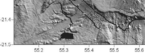
15 tized anomaly. Such an alignment between the structures could be explained by the occurrence of a large N70 N80 fault in the eastern part of the edifice. Finally, the southern submarine flank of PdF is characterised by a N150 lineament for which sonar images show that it does not consist of either a geological limit or an incised channel (Figure 11b). It is noteworthy that the N direction also corresponds to clear lineaments and geophysical structures (inferred from time domain electromagnetic and audiomagnetotelluric methods) in the southern subaerial flank of PdF (Figure 8). Thus we show that the different faults observed in the subaerial part of PdF coincide with those on a larger scale Oceanic Crust Orientations [27] Recent aeromagnetic, sea level magnetic, seismic surveys, and bathymetric data allowed the determination of the structures of oceanic crust in the surrounding areas of La Réunion and Mauritius Islands [Dyment, 1991; de Voogd et al., 1999; Lénat et al., 2001]. Around the islands, the lithosphere shows N30 40 transform zones and N trending magnetic anomalies (Figure 1a). The N crustal orientation is also present below the island as suggested by the global alignment of the magmatic massifs of La Réunion, and the elongated seamount located on the western submarine flank (Figure 11a). This general pattern with two main crustal orientations changes between La Réunion Island and the Mauritius transform zone where magnetic anomalies trend in the N80 direction. The presence of this crustal orientation below the eastern part of the volcanic edifice has been revealed by seismic data, which show the occurrence of a N80 trending basement high below the Eastern Plateau [de Voogd et al., 1999]. Bathymetric data [Smith and Sandwell, 1997; Fretzdorff et al., 1998] indicate that south of the island the crust is characterized by N55 60 trending topographic ridges and elongated seamounts, which continue below the eastern part of the island (Figure 12a). 5. Discussion and Conclusions 5.1. Scale Integration [28] Our study aimed at the characteristics of tectonic and volcanic structures at different scales allowing comparison of large and small-scale structures (i.e., oceanic crust, submarine and island structures, volcano faults, and eruptive fissures). [29] We showed that each structural level is characterized by several structural orientations. It is hard to discriminate for a given structural level alone whether the different structures are related to large-scale processes or to local effects due to the intraedifice stress field or volcano evolution. However, the combination of several scales allows distinction of these origins. Indeed, structures induced by local effects such as the intraedifice deformation, the landslide-induced stress field, or magmatic overpressure are restricted to the edifice, whereas large-scale deformation may influence the development of multiscale structures. To this respect, the data show the recurrence of several structural trends from the crustal scale to the small-scale magmatic system of PdF (i.e., N30 40, N70 80, and N ; Figure 12b). The N30 40 and N trends correspond to (1) preferential directions of magmatic intrusion at both PdF and PdN, (2) the elongation of dense intrusive complexes in PdN and between PdF and PdN [Malengreau et al., 1999], (3) two of the main fault trends of PdN [Chevallier, 1979], and (4) the regional orientations of the transform zone and spreading center. Even though the N70 faults are observed in PdN [Chevallier, 1979], the N70 80 structural direction is mainly restricted to PdF and between PdF and the Mauritius transform zone. This structural orientation is represented by (1) surface and subsurface structures in the N and S flanks of PdF (Figures 8 and 9), (2) a strong reverse anomaly below the E submarine flank (Figure 10b) [Lénat et al., 2001], (3) an elongated basement high [de Voogd et al., 1999], and (4) the local crustal fabrics revealed by magnetic anomalies (Figure 1). We interpret the parallelism between the magmatic, the island scale, and crustal structures as resulting from a structural control played by the oceanic crust in the past and present construction of La Réunion s volcanoes. [30] Other structures such as the N05 fault zone south of PdF or the N160 rift zone of PdN, which are spatially isolated and not observed at different structural levels may formed as the consequence of independent geological processes. Local geological events such as flank destabilization are able to control the development of volcanic rift zones [e.g., Tibaldi, 2003; Walter and Troll, 2003]. The deformation of a volcano above a décollement level [e.g., Merle and Borgia, 1996] is an additional feature to decouple the structural influence of both the oceanic crust and the volcanic edifice. In consequence, we consider that the secondary structural directions in La Réunion s volcanoes may result from intraedifice processes rather than a regional stress-field Origin of the Large-Scale Deformation General Context [31] La Réunion Island is located east of Madagascar and on the southeastern rim of the Mascarene Basin. Magnetic anomalies indicate that this basin results from oceanic extension between the Campanian (Late Cretaceous; anomaly 34) and the Early Paleocene (anomaly 27 [e.g., Dyment, 1991]). This extension was accommodated by large transform zones such as the Wilshaw Ridge and the Mauritius Transform Zone (Figure 1a). Between these two transform zones, the age and the structure of the crustal domain on which La Réunion Island is built are poorly constrained. Figure 10. (a) Digital Terrain Model (DTM) of the sub-aerial part and proximal sub-marine flanks of La Réunion Island. The island presents a N elongation. According to Chevallier [1979], the magmatic intrusions of Piton des Neiges were restricted to four rift zones (N10, N45, N120, and N160). Note that the well-developed Etang-Salé rift zone, which forms a submarine ridge and is characterized by a cone alignment, was not considered by Chevallier [1979]. (b) Sea-level magnetic map showing the N35 reverse magnetized anomaly of the Etang-Salé rift zone. The N80 reverse magnetized anomaly east of the Piton de la Fournaise is interpreted as a remnant part of the Alizés volcano (after Lénat et al. [2001]). 15 of 21
![Dyment [1991] proposed that the island is located at the intersection](/docs-images/77/75693121/images/16-0.jpg "of a small-scale transform zone and a paleoridge.")


16 Dyment [1991] proposed that the island is located at the intersection of a small-scale transform zone and a paleoridge. Whatever the exact structure, the age of the oceanic spreading in the Mascarene Basin suggests that the transform zones are tectonically inactive since 60 m.y. Consequently, the recent, active deformation determined in the present study and the seismicity on an island scale are Figure of 21
17 hardly explainable by the present-day activity of the paleoridge and the transform zones Effect of the Mantle Plume and the Magmatic Underplating [32] Geophysical campaigns in the past decades have allowed the determination of the crustal topography around and below the main volcanic islands [Watts et al., 1985; Binard et al., 1991; Watts et al., 1997; de Voogd et al., 1999; Ali et al., 2003]. Large lithospheric flexures have been determined below the Hawaiian chain [Watts et al., 1985] and the Tenerife Island [Watts et al., 1997]. In the island s vicinity, the lithospheric flexure led to the formation of large angular unconformities between prevolcanic and syn/postvolcanic formations [e.g., Watts et al., 1997, Figure 2]. In the Cape Verde Islands, angular unconformities reveal a past crustal flexure during the Miocene, which has been subsequently balanced by a general uplift [Ali et al., 2003]. In contrast to these evolutions, reflection seismic data in La Réunion Island show a lack of angular unconformity, firmly establishing the lack of significant vertical downward movement and flexure [de Voogd et al., 1999]. Furthermore, the base of the edifice that is the top of the preexisting oceanic plate is roughly domed and is characterised by several N55 60 and N80 topographic highs and lows. [33] The amount of lithospheric flexure is controlled by three main parameters: (1) the size of the volcanic edifice (i.e., the surface load), (2) the elastic thickness of the lithosphere (T e ) which depends on the effective flexural rigidity (D e )[Burov and Diament, 1995], and (3) the subsurface upward loads induced by underplated materials and lithospheric thinning [Watts et al., 1980; Ali et al., 2003]. As the height of La Réunion, Cape Verde, Hawaii, and Tenerife islands are of the same order of magnitude, the downward load due to the volcano weight are roughly similar and it cannot explain alone the differences observed in the crust geometry. One could consider that the lack of lithospheric flexure in La Réunion Island could be caused by different T e values in La Réunion Island, Hawaii, Cape Verde, and Tenerife. However, T e values of the oceanic lithosphere are nearly similar in La Réunion (28 km [Bonneville, 1990]), Cape Verde (29 km [Ali et al., 2003]), Tenerife (26 km [Watts et al., 1997]), and Hawaii (30 35 km [Wessel and Keating, 1994]). Even if the T e values may present uncertainties due to the complexity of determining the effective flexural rigidity for a oceanic lithosphere (A. Gudmundsson, personal communication, 2006), the normal value of lithosphere elastic thickness in La Réunion Island cannot explain the lack of flexure and moreover the slight doming of the edifice basement. Two different processes may produce upward forces and subsequent doming: (1) a thermal erosion of the base of the lithosphere caused by the mantle anomaly and (2) magmatic underplating. The amount of thermally eroded lithosphere and the related uplift depend on the time that a lithosphere stays above a hot anomaly. Large isostatic disequilibrium will be favored in slow plate motion settings and almost nonexistent in fast moving plates (Figure 13). It has been proposed that the displacement of La Réunion Island relative to the hot spot, for the time of known volcanic activity (2.1 My [MacDougall, 1971]), was less than 40 km [Charvis et al., 1999]. In such a context, an efficient lithospheric thinning was possible. Furthermore, geophysical data reveal that a large amount of underplated material exists below the southwestern part of La Réunion edifice [Charvis et al., 1999], supporting the underplating hypothesis as an additional cause of the doming. [34] Hence we interpret the slight crustal doming below La Réunion Island as resulting from a combination of lithospheric thinning due to thermal erosion and magmatic underplating Consequences in the Evolution of La Réunion Volcanoes [35] The development of a dome-like geometry of the oceanic basement and the occurrence of 500 to 1500 m of pelagic sediments [de Voogd et al., 1999] below the volcanic edifice potentially had strong influences in the evolution of the volcanoes on La Reunion. [36] The dome-like geometry suggests that the oceanic crust underwent an uplift during the development of the edifice. In a continental setting, the uplift of the lithosphere induces the reactivation of preexisting crustal structures (inherited faults and/or metamorphic fabrics) which subsequently control the location of the volcanism and the geometry of the extension structures [e.g., Le Gall et al., 2004]. In a similar way, we interpret the uplift of the oceanic lithosphere at La Réunion as the motor of the reactivation of the preexisting crustal faults. Such a reactivation can explain the parallelism between the crustal structures and most of the structures observed on the volcanoes. It is obviously wrong to consider that each fault or rift zone observed at the surface is directly linked to reactivated crustal faults. Several additional factors potentially triggered the development of tectonic and magmatic structures. The huge amount of mass deposits on the submarine flanks of the edifice [e.g., Labazuy, 1996; Oehler et al., 2004] and in the subaerial part [Bachèlery et al., 2003; Bret et al., 2003] suggests that large flank destabilizations occurred during the evolution of the volcano. The occurrence of large landslides may have produced a rift zone reorientation [e.g., Walter and Troll, 2003] and an isostatic deformation [Smith and Wessel, 2000]. The deformation of a volcano above low strength layers [Borgia, 1994; Merle and Borgia, 1996; Oehler et al., 2005] can also develop independent stress fields that lead to the formation of numerous faults. Although a large-scale spreading could have theoretically occurred at La Réunion Island (presence of potential décollement layer at the base of Figure 11. (a) DTM of the bathymetry showing the distribution of the mass deposits which are mainly concentrated in four bulges (the western, southern, and northern bulges and the Eastern Plateau [Oehler et al., 2004]). The main faults of PdF inferred in this study are represented by black lines. Small arrows indicate the N80, and N05 lineaments visible in the submarine flanks which are aligned with subaerial structures. The N150 lineament is parallel to the structures observed on the southern flank of PdF. Rectangle in dashed line represents the location of Figure 10b. (b) Sonar image of the southern submarine flank of PdF showing the location of the N150 lineament (white arrows) and the distinct geological formations. Note that the lineament does not correspond to either the limit of geological formations or to an incised channel. 17 of 21
")


18 Figure 12. (a) Distribution of the main structures of PdF, PdN, La Réunion edifice and the oceanic crust. Yellow, red and green lines correspond to the N30 40, N , and N70 80 structural trends, respectively. (b) Summary of the main trends observed at different scales: Piton de la Fournaise, island, and crust. 18 of 21

19 Figure 13. (a) The impact of a plume emplacement below a fast moving plate. The fast plate movement above the mantle anomaly does not allow significant thermal erosion of the base of the lithosphere below the volcanic island. The volcano load subsequently leads to a lithospheric flexure as in Hawaii. Dotted shapes represent the mantle anomaly location at different times. (b) Efficient thermal erosion of a slow moving lithosphere. The thermal erosion induces an isostatic disequilibrium and an uplift of the lithosphere, which at least balances the load of the volcanic edifice. This evolution may partly explain the lack of lithospheric flexure below La Réunion Island. the edifice), its existence is still unclear. The pelagic sediments below the submarine flanks are undeformed and no expected distal anticline and thrust are observed in reflection seismic data on the SW and NE flank, even several tens of kilometers away from the volcano [de Voogd et al., 1999]. Additional to the large-scale spreading, Oehler et al. [2005] proposed that small-scale low strength layers (e.g., deltas and hyaloclastites layers) have induced the edifice deformation and flank landslides. [37] We therefore propose that the deformation of La Réunion Island and the development of the magmatic rift zones result from the superposition of a general stress field, which is induced by the uplift of the oceanic crust, and local stress fields related to the dynamics and settings of each of the volcanoes. [38] The volcanoes of La Réunion experienced recurrent flank destabilizations [Oehler, 2005]. Recent field observations [Bachèlery et al., 2003; Bret et al., 2003] and analogue experiments [Merle and Lénat, 2003; Oehler et al., 2005] suggest that the landslides of La Réunion are due and/or favored by the occurrence of low strength levels in the edifice. Most of these low strength layers correspond to hydrothermally altered materials which mainly develop in the vicinity of the intrusive complex of PdN, PdF, and the Alizés volcano. We propose that the presence of in situ décollement composed of hydrothermally altered and weakened materials is probably not the only cause of a landslide. Indeed, analogue models show that the reactivation in normal faulting mode of crustal preexisting faults below a volcanic edifice leads to the development of normal and reverse faults in the volcano, which can result in gravity instabilities such as flank landslides [Vidal and Merle, 2000]. The stability of the edifice decreases when oblique basement faults are simultaneously reactivated and landslides occur after vertical basement displacements of m. Such large amplitudes of vertical displacement are currently not observed in the subaerial part of La Réunion. However, as the faults correspond to the lateral borders of the landslides, the initial offsets related to the reactivation of the basement fault would have not been preserved in the upper part of the edifice. Moreover, the analogue experiment of Vidal and Merle [2000] was carried out with brittle materials only. It has been widely demonstrated that the occurrence of low strength materials in volcanoes is a crucial parameter in the deformation and the destabilization of the edifice [e.g., Siebert, 1984; Day, 1996; Cecchi et al., 2005] We hypothesize that the deformation related to the reactivation of the basement fault would be enhanced by the presence of hydrothermally weakened material in the edifice. Part of the widespread landslides in La Réunion Island would consequently result from the combination of basement fault reactivation and the occurrence of hydrothermally altered materials. [39] Acknowledgments. The authors want to thank Andrea Borgia, Olivier Merle, and Jurgen Neuberg for their constructive comments on the initial version of the manuscript. Philippe Mairine guided us in the Rivière des Remparts. Thanks are also given to Jean-Luc Froger, Philippe Labazuy, and Jean-Francois Lénat for stimulating discussions on the volcano evolution and to Jean-François Oelher who provided the DTM of the bathymetry. Valerie Ferrazzini kindly provided the map of the island seismicity. The reviews of Joan Marti and Agus Gudmundsson helped in the improvement of the manuscript. This work was partly funded by the BQR 2004 provided by the University of La Réunion to L.M. References Ali, M. Y., A. B. Watts, and I. Hill (2003), A seismic reflection profile study of lithospheric flexure in the vicinity of the Cape Verde Islands, J. Geophys. Res., 108(B5), 2239, doi: /2002jb Arnaud, N. (2005), Les processus de démantèlement des volcans; le cas d un volcan bouclier en milieu océanique: Le Piton des Neiges (Ile de la Réunion), Ph.D. thesis, 407 pp., Univ. la Réunion, Saint-Denis Messag, France. Bachèlery, P. (1981), Le Piton de la Fournaise (Ile de la Réunion): Etude volcanologique, structurale et pétrologique, Ph.D. thesis, Univ. é Clermont-Ferrand II, Clermont-Ferrand, France. Bachèlery, P., and P. Mairine (1990), Evolution volcano-structurale du Piton de la Fournaise depuis 0,53 Ma, in Le Volcanisme de la Réunion, edited by J.-F. Lénat, pp , Cent. de Rech. Volcanol., Clermont- Ferrand, France. Bachèlery, P., L. Chevalier, and J.-F. Gratier (1983), Caractères structuraux des éruptions historiques du Piton de la Fournaise, C. R. Acad. Sci., 296, Bachèlery, P., B. Robineau, M. Courteaud, and C. Savin (2003), Avalanches de débris sur le flanc occidental du volcan-bouclier Piton des Neiges (Réunion), Bull. Soc. Geol. Fr., 174, Battaglia, J., and P. Bachèlery (2003), Dynamic dyke propagation deduced from tilt variations preceding the March 9, 1998, eruption of Piton de la Fournaise volcano, J. Volcanol. Geotherm. Res., 120, Binard, N., R. Hékinian, J. L. Cheminée, R. C. Searle, and P. Stoffers (1991), Morphological and structural studies of the Society and 19 of 21
Morphology of Piton de la Fournaise basaltic shield volcano (La Réunion Island): Characterization and implication in the volcano evolution
: Characterization and implication in the volcano evolution") JOURNAL OF GEOPHYSICAL RESEARCH, VOL. 113,, doi:10.1029/2005jb004118, 2008 Morphology of Piton de la Fournaise basaltic shield volcano (La Réunion Island): Characterization and implication in the volcano
JOURNAL OF GEOPHYSICAL RESEARCH, VOL. 113,, doi:10.1029/2005jb004118, 2008 Morphology of Piton de la Fournaise basaltic shield volcano (La Réunion Island): Characterization and implication in the volcano
Plate Tectonics. entirely rock both and rock
 Plate Tectonics I. Tectonics A. Tectonic Forces are forces generated from within Earth causing rock to become. B. 1. The study of the origin and arrangement of Earth surface including mountain belts, continents,
A - Piton de la Fournaise activity
 OVPF-IPGP August 2018 Page 1/7 Monthly bulletin of the Piton de la Fournaise Volcanological Observatory ISSN ISSN 2610-5101 A - Piton de la Fournaise activity PITON DE LA FOURNAISE (VNUM #233020) Latitude:
How summit calderas collapse on basaltic volcanoes: new insights from the April 2007 caldera collapse of Piton de la Fournaise volcano
 IOP Conference Series: Earth and Environmental Science How summit calderas collapse on basaltic volcanoes: new insights from the April 2007 caldera collapse of Piton de la Fournaise volcano To cite this
What Forces Drive Plate Tectonics?
 What Forces Drive Plate Tectonics? The tectonic plates are moving, but with varying rates and directions. What hypotheses have been proposed to explain the plate motion? Convection Cells in the Mantle
24. Ocean Basins p
 24. Ocean Basins p. 350-372 Background The majority of the planet is covered by ocean- about %. So the majority of the Earth s crust is. This crust is hidden from view beneath the water so it is not as
Structural Geology tectonics, volcanology and geothermal activity. Kristján Saemundsson ÍSOR Iceland GeoSurvey
 Structural Geology tectonics, volcanology and geothermal activity Kristján Saemundsson ÍSOR Iceland GeoSurvey Discussion will be limited to rift zone geothermal systems with sidelook on hot spot environment.
A) B) C) D) 4. Which diagram below best represents the pattern of magnetic orientation in the seafloor on the west (left) side of the ocean ridge?
 B) C) D) 4. Which diagram below best represents the pattern of magnetic orientation in the seafloor on the west (left) side of the ocean ridge?") 1. Crustal formation, which may cause the widening of an ocean, is most likely occurring at the boundary between the A) African Plate and the Eurasian Plate B) Pacific Plate and the Philippine Plate C)
1. Crustal formation, which may cause the widening of an ocean, is most likely occurring at the boundary between the A) African Plate and the Eurasian Plate B) Pacific Plate and the Philippine Plate C)
Growth and collapse of the Reunion Island volcanoes
 Bull Volcanol (2008) 70:717 742 DOI 10.1007/s00445-007-0163-0 RESEARCH ARTICLE Growth and collapse of the Reunion Island volcanoes Jean-François Oehler & Jean-François Lénat & Philippe Labazuy Received:
10. Paleomagnetism and Polar Wandering Curves.
 Map of ocean floor Evidence in Support of the Theory of Plate Tectonics 10. Paleomagnetism and Polar Wandering Curves. The Earth's magnetic field behaves as if there were a bar magnet in the center of
OCN 201 Mantle plumes and hot spots
 OCN 201 Mantle plumes and hot spots Question Long-term (>50 million years) changes in sea level are caused by: A. Changes in the volume of water in the ocean B. Changes in the volume of the ocean basins
PHYSICAL GEOLOGY AND THE ENVIRONMENT (2 ND CANADIAN EDITION)
") Chapter 2: Plate Tectonics Chapter Summary: Plate tectonics is a theory that suggests Earth's surface is divided into several large plates that change position and size. Intense geologic activity occurs
Chapter 2: Plate Tectonics Chapter Summary: Plate tectonics is a theory that suggests Earth's surface is divided into several large plates that change position and size. Intense geologic activity occurs
Lab 1: Plate Tectonics April 2, 2009
 Name: Lab 1: Plate Tectonics April 2, 2009 Objective: Students will be introduced to the theory of plate tectonics and different styles of plate margins and interactions. Introduction The planet can be
The influence of short wavelength variations in viscosity on subduction dynamics
 1 Introduction Deformation within the earth, driven by mantle convection due primarily to cooling and subduction of oceanic lithosphere, is expressed at every length scale in various geophysical observations.
Alternative Mechanisms for Volcanic Activity in Hotspot-Ridge Systems: The Northern Galapagos Province
 ABSTRACT for the Plume IV Penrose Conference Alternative Mechanisms for Volcanic Activity in Hotspot-Ridge Systems: The Northern Galapagos Province Karen S. Harpp, Colgate University, Department of Geology,
A - Piton de la Fournaise activity
 OVPF-IPGP November 2018 Page 1/7 Monthly bulletin of the Piton de la Fournaise Volcanological Observatory ISSN ISSN 2610-5101 A - Piton de la Fournaise activity PITON DE LA FOURNAISE (VNUM #233020) Latitude:
Earthquakes. Earthquakes are caused by a sudden release of energy
 Earthquakes Earthquakes are caused by a sudden release of energy The amount of energy released determines the magnitude of the earthquake Seismic waves carry the energy away from its origin Fig. 18.1 Origin
Chapter 2 Plate Tectonics and the Ocean Floor
 Chapter 2 Plate Tectonics and the Ocean Floor Matching. Match the term or person with the appropriate phrase. You may use each answer once, more than once or not at all. 1. hydrothermal vents A. convergent
Earth s Continents and Seafloors. GEOL100 Physical Geology Ray Rector - Instructor
 Earth s Continents and Seafloors GEOL100 Physical Geology Ray Rector - Instructor OCEAN BASINS and CONTINENTAL PLATFORMS Key Concepts I. Earth s rocky surface covered by of two types of crust Dense, thin,
The Structure of the Earth and Plate Tectonics
 The Structure of the Earth and Plate Tectonics Agree or Disagree? 1. The Earth if made up of 4 different layers. 2. The crust (where we live) can be made of either less dense continental crust or the more
TAKE HOME EXAM 8R - Geology
 Name Period Date TAKE HOME EXAM 8R - Geology PART 1 - Multiple Choice 1. A volcanic cone made up of alternating layers of lava and rock particles is a cone. a. cinder b. lava c. shield d. composite 2.
NC Earth Science Essential Standards
 NC Earth Science Essential Standards EEn. 2.1 Explain how processes and forces affect the Lithosphere. EEn. 2.1.1 Explain how the rock cycle, plate tectonics, volcanoes, and earthquakes impact the Lithosphere.
Plate Tectonics Lab II: Background Information
 Plate Tectonics Lab II: Background Information This lab is based on a UW ESS101 Lab. Note: Hand in only the Answer Sheet at the back of this guide to your Instructor Introduction One of the more fundamental
REVIEW: The Setting - Climatology of the Hawaiian Archipelago
 REVIEW: The Setting - Climatology of the Hawaiian Archipelago Atmosphere and Ocean 5 facts: NE trade-winds tropical water subtropical gyre Seasonality N S gradients Four dominant swell regimes: north Pacific
A - Piton de la Fournaise activity
 OVPF-IPGP September 2018 Page 1/10 Monthly bulletin of the Piton de la Fournaise Volcanological Observatory ISSN ISSN 2610-5101 A - Piton de la Fournaise activity PITON DE LA FOURNAISE (VNUM #233020) Latitude:
Plate Tectonics: A Unifying Theory
 Plate Tectonics: A Unifying Theory What is Plate Tectonics? - 7 large tectonic plates and many smaller ones that break up the lithosphere - Plates are brittle and float on asthenosphere and glide past
Chapter 10: Deformation and Mountain Building. Fig. 10.1
 Chapter 10: Deformation and Mountain Building Fig. 10.1 OBJECTIVES Describe the processes of rock deformation and compare and contrast ductile and brittle behavior in rocks. Explain how strike and dip
Continental Margin Geology of Korea : Review and constraints on the opening of the East Sea (Japan Sea)
") Continental Margin Geology of Korea : Review and constraints on the opening of the East Sea (Japan Sea) Han-Joon Kim Marine Satellite & Observation Tech. Korea Ocean Research and Development Institute
Continental Margin Geology of Korea : Review and constraints on the opening of the East Sea (Japan Sea) Han-Joon Kim Marine Satellite & Observation Tech. Korea Ocean Research and Development Institute
12. The diagram below shows the collision of an oceanic plate and a continental plate.
 Review 1. Base your answer to the following question on the cross section below, which shows the boundary between two lithospheric plates. Point X is a location in the continental lithosphere. The depth
GEOLOGY MEDIA SUITE Chapter 12
 UNDERSTANDING EARTH, SIXTH EDITION GROTZINGER JORDAN GEOLOGY MEDIA SUITE Chapter 12 Volcanoes 2010 W.H. Freeman and Company Plate tectonics explains the global pattern of volcanism. Key Figure 12.20 (page
Continental Landscapes
 Continental Landscapes Landscape influenced by tectonics, climate & differential weathering Most landforms developed within the last 2 million years System moves toward an equilibrium Continental Landscapes
Geologic Structures. Changes in the shape and/or orientation of rocks in response to applied stress
 Geologic Structures Changes in the shape and/or orientation of rocks in response to applied stress Figure 15.19 Can be as big as a breadbox Or much bigger than a breadbox Three basic types Fractures >>>
Full file at
 Chapter 2 PLATE TECTONICS AND PHYSICAL HAZARDS MULTIPLE-CHOICE QUESTIONS 1. What direction is the Pacific Plate currently moving, based on the chain of Hawaiian Islands with only the easternmost island
Plate Tectonics: A Scientific Revolution Unfolds
 Chapter 2 Lecture Earth: An Introduction to Physical Geology Eleventh Edition Plate Tectonics: A Scientific Revolution Unfolds Tarbuck and Lutgens From Continental Drift to Plate Tectonics Prior to the
Crustal Boundaries. As they move across the asthenosphere and form plate boundaries they interact in various ways. Convergent Transform Divergent
 Name: Date: Period: Plate Tectonics The Physical Setting: Earth Science CLASS NOTES Tectonic plates are constantly moving and interacting As they move across the asthenosphere and form plate boundaries
GENERAL GEOLOGY Fall Chapter 18: The Sea Floor. Partial Examination IV Study Guide Dr. Glen S. Mattioli
 GENERAL GEOLOGY 1113-005 Fall 2008 Partial Examination IV Study Guide Dr. Glen S. Mattioli Note that these are NOT questions, but rather are a list of topics that we have covered either in class or are
Plate Tectonics. Continental Drift Sea Floor Spreading Plate Boundaries
 Plate Tectonics Continental Drift Sea Floor Spreading Plate Boundaries Continental Drift 1915, Alfred Wegener - Pangea hypothesis: suggested Earth s continents were part of a large super-continent 200
Journal of Volcanology and Geothermal Research
 Journal of Volcanology and Geothermal Research 184 (2009) 14 30 Contents lists available at ScienceDirect Journal of Volcanology and Geothermal Research journal homepage: www.elsevier.com/locate/jvolgeores
UNIT 3 GEOLOGY VOCABULARY FLASHCARDS THESE KEY VOCABULARY WORDS AND PHRASES APPEAR ON THE UNIT 3 CBA
 UNIT 3 GEOLOGY VOCABULARY FLASHCARDS THESE KEY VOCABULARY WORDS AND PHRASES APPEAR ON THE UNIT 3 CBA A map that shows Earth s Topographic Map surface topography, which is Earth s shape and features Contour
Before Plate Tectonics: Theory of Continental Drift
 Before Plate Tectonics: Theory of Continental Drift Predecessor to modern plate tectonics Shape and fit of the continents was the initial evidence Snider-Pelligrini (1858) Taylor (1908) Wegner (1915) Fig.
Answers: Internal Processes and Structures (Isostasy)
") Answers: Internal Processes and Structures (Isostasy) 1. Analyse the adjustment of the crust to changes in loads associated with volcanism, mountain building, erosion, and glaciation by using the concept
Answers: Internal Processes and Structures (Isostasy) 1. Analyse the adjustment of the crust to changes in loads associated with volcanism, mountain building, erosion, and glaciation by using the concept
Full file at
 Essentials of Oceanography, 10e (Trujillo/Keller) Chapter 2 Plate Tectonics and the Ocean Floor Match the term with the appropriate phrase. You may use each answer once, more than once or not at all. A)
GLY 155 Introduction to Physical Geology, W. Altermann. Press & Siever, compressive forces. Compressive forces cause folding and faulting.
 Press & Siever, 1995 compressive forces Compressive forces cause folding and faulting. faults 1 Uplift is followed by erosion, which creates new horizontal surface. lava flows Volcanic eruptions cover
Isostasy and Tectonics Lab Understanding the Nature of Mobile Floating Lithospheric Plates
 Isostasy and Tectonics Lab Understanding the Nature of Mobile Floating Lithospheric Plates Crust Mantle Dynamics Introductory Geology Lab Ray Rector - Instructor Isostasy and Tectonics Laboratory Topics
Copyright McGraw-Hill Education. All rights reserved. No reproduction or distribution without the prior written consent of McGraw-Hill Education
 Copyright McGraw-Hill Education. All rights reserved. No reproduction or distribution without the prior written consent of McGraw-Hill Education Tibetan Plateau and Himalaya -southern Asia 11.00.a VE 10X
Earth and Space Science Semester 2 Exam Review. Part 1. - Convection currents circulate in the Asthenosphere located in the Upper Mantle.
 Earth and Space Science 2015 Semester 2 Exam Review Part 1 Convection -A form of heat transfer. - Convection currents circulate in the Asthenosphere located in the Upper Mantle. - Source of heat is from
180 points. 1. Lava erupts through an opening in Earth s crust called a. 2. A bowl-shaped depression that forms around the vent of a volcano is a
 CHAPTER 18 Volcanism SECTION 18.1 Volcanoes In your textbook, read about the anatomy of a volcano and volcanic material. Completes each statement or answer the question. 25 points 180 points volcano. In
Section 10.1 The Nature of Volcanic Eruptions This section discusses volcanic eruptions, types of volcanoes, and other volcanic landforms.
 Chapter 10 Section 10.1 The Nature of Volcanic Eruptions This section discusses volcanic eruptions, types of volcanoes, and other volcanic landforms. Reading Strategy Previewing Before you read the section,
The Structure of the Earth and Plate Tectonics
 The Structure of the Earth and Plate Tectonics Structure of the Earth The Earth is made up of 4 main layers: Inner Core Outer Core Mantle Crust Crust Mantle Outer core Inner core The Crust This is where
Laboratory #7: Plate Tectonics
 Materials Needed: 1. Pencil 2. Colored Pencils 3. Metric/Standard Ruler 4. Calculator 5. Tracing Paper Laboratory #7: Plate Tectonics Plate Tectonics The Earth is composed of layers. At the center is a
Forces That Shape Earth. How do continents move? What forces can change rocks? How does plate motion affect the rock cycle?
 Forces That Shape Earth How do continents move? What forces can change rocks? How does plate motion affect the rock cycle? Plate Motion Mountain ranges are produced by plate tectonics. The theory of plate
Seafloor Spreading and Paleomagnetism Activity
 Name: PART A: Ocean Bottom Profile Background: Seafloor spreading is the hypothesis that the sea floor moves sideways away from the crest of the mid- ocean ridge. It is estimated that 20 volcanic eruptions
COSMORPHOLOGY - May 2009
 Name COSMORPHOLOGY - May 2009 Geologic landforms Purpose: By studying aerial photographs you will learn to identify different kinds of geologic features based on their different morphologies and learn
Chapter 10: Volcanoes and Other Igneous Activity Section 1: The Nature of Volcanic Eruptions I. Factors Affecting Eruptions Group # Main Idea:
 Chapter 10: Volcanoes and Other Igneous Activity Section 1: The Nature of Volcanic Eruptions I. Factors Affecting Eruptions Group # A. Viscosity Group # B. Dissolved Gases Group # II. Volcanic Material
4 Deforming the Earth s Crust
 CHAPTER 7 4 Deforming the Earth s Crust SECTION Plate Tectonics BEFORE YOU READ After you read this section, you should be able to answer these questions: What happens when rock is placed under stress?
Continental Drift and Plate Tectonics
 Continental Drift and Plate Tectonics Continental Drift Wegener s continental drift hypothesis stated that the continents had once been joined to form a single supercontinent. Wegener proposed that the
Geology 300, Physical Geology Spring 2019 Quiz Ch 19, Plate Tectonics Name
 Geology 300, Physical Geology Spring 2019 Quiz Ch 19, Plate Tectonics Name MULTIPLE CHOICE. Choose the one alternative that best completes the statement or answers the question. 1) The portion of a fracture
Cenozoic Extensional Basin Development and Sedimentation in SW Montana
 Cenozoic Extensional Basin Development and Sedimentation in SW Montana Robert C. Thomas Department of Environmental Sciences, The University of Montana Western, Dillon, MT 59725, (406) 683-7615, r_thomas@umwestern.edu
MULTIPLE CHOICE. Choose the one alternative that best completes the statement or answers the question.
 Geology 300, Physical Geology Spring 2019 Quiz Chapter 18, Seafloor Name MULTIPLE CHOICE. Choose the one alternative that best completes the statement or answers the question. 1) Abyssal fans are made
Prentice Hall EARTH SCIENCE
 Prentice Hall EARTH SCIENCE Tarbuck Lutgens Chapter 9 Plate Tectonics 9.1 Continental Drift An Idea Before Its Time Wegener s continental drift hypothesis stated that the continents had once been joined
Prentice Hall EARTH SCIENCE
 Prentice Hall EARTH SCIENCE Tarbuck Lutgens Chapter 9 Plate Tectonics 9.1 Continental Drift An Idea Before Its Time Wegener s continental drift hypothesis stated that the continents had once been joined
Geologic Mapping Invitational Trial Event
 Geologic Mapping Invitational Trial Event A TEAM OF UP TO: 2 Team Name AVAILABLE TIME: 50 min Required Materials: Each team MUST have a protractor, ruler, non-programmable calculator, colored pencils,
Chapter 2 Plate Tectonics and the Ocean Floor
 Chapter 2 Plate Tectonics and the Ocean Floor Chapter Overview Much evidence supports plate tectonics theory. The plate tectonics model describes features and processes on Earth. Plate tectonic science
Name Class Date. Study Guide for 7 th Grade Final Exam (Semester One)
") Name Class Date Study Guide for 7 th Grade Final Exam (Semester One) 1. What are the steps of the scientific method? Define the problem or question Form a hypothesis (MUST BE TESTABLE) o (identify variables)
Name Class Date Study Guide for 7 th Grade Final Exam (Semester One) 1. What are the steps of the scientific method? Define the problem or question Form a hypothesis (MUST BE TESTABLE) o (identify variables)
The Ocean Floor Earth Science, 13e Chapter 13
 The Ocean Floor Earth Science, 13e Chapter 13 Stanley C. Hatfield Southwestern Illinois College The vast world ocean Earth is often referred to as the blue planet Seventy-one percent of Earth s surface
Shape Earth. Plate Boundaries. Building. Building
 Chapter Introduction Lesson 1 Lesson 2 Lesson 3 Lesson 4 Chapter Wrap-Up Forces That Shape Earth Landforms at Plate Boundaries Mountain Building Continent Building How is Earth s surface shaped by plate
Visualizing Earth Science. Chapter Overview. Volcanoes and Eruption Types. By Z. Merali and B. F. Skinner. Chapter 9 Volcanism and Other
 Visualizing Earth Science By Z. Merali and B. F. Skinner Chapter 9 Volcanism and Other Igneous Processes Volcanoes types and effects of eruption Chapter Overview Melting and cooling of rocks Geological
Convergent plate boundaries. Objective to be able to explain the formation and key features of these zones.
 Convergent plate boundaries Objective to be able to explain the formation and key features of these zones. Destructive plate margins When plates collide due to convection currents/slab pull in the asthenosphere
Topic 12: Dynamic Earth Pracatice
 Name: Topic 12: Dynamic Earth Pracatice 1. Earth s outer core is best inferred to be A) liquid, with an average density of approximately 4 g/cm 3 B) liquid, with an average density of approximately 11
Examining the Terrestrial Planets (Chapter 20)
") GEOLOGY 306 Laboratory Instructor: TERRY J. BOROUGHS NAME: Examining the Terrestrial Planets (Chapter 20) For this assignment you will require: a calculator, colored pencils, a metric ruler, and your geology
GEOLOGY 306 Laboratory Instructor: TERRY J. BOROUGHS NAME: Examining the Terrestrial Planets (Chapter 20) For this assignment you will require: a calculator, colored pencils, a metric ruler, and your geology
Geology 15 West Valley College. Exam IV: Sierra Nevada
 Geology 15 West Valley College Name Exam IV: Sierra Nevada 1) On the diagram above, where is the Arc- Trench Gap? a. 1 and 3 c. 7 and 8 d. 6 e. 5 and 10 2) On the diagram above, where is the subduction
OS 1 The Oceans Fall 2007
 Name: Plate Tectonics (you must turn Activities 1-2 in during Section) Activity 1: Plate Boundaries A plate boundary simply describes where two plates (either oceanic or continental material) meet. There
General Oceanography Geology 105 Expedition 8 Plate Boundaries Beneath the Sea Complete by Thursday at 11:00 PM
 General Oceanography Geology 105 Expedition 8 Plate Boundaries Beneath the Sea Complete by Thursday at 11:00 PM Name Expedition Objectives Learn about the types of plate boundaries and their key characteristics
D) outer core B) 1300 C A) rigid mantle A) 2000 C B) density, temperature, and pressure increase D) stiffer mantle C) outer core
 outer core B) 1300 C A) rigid mantle A) 2000 C B) density, temperature, and pressure increase D) stiffer mantle C) outer core") 1. In which area of Earth's interior is the pressure most likely to be 2.5 million atmospheres? A) asthenosphere B) stiffer mantle C) inner core D) outer core Base your answers to questions 2 and 3 on
1. In which area of Earth's interior is the pressure most likely to be 2.5 million atmospheres? A) asthenosphere B) stiffer mantle C) inner core D) outer core Base your answers to questions 2 and 3 on
Geomorphology Final Exam Study Guide
 Geomorphology Final Exam Study Guide Geologic Structures STRUCTURAL GEOLOGY concerned with shapes, arrangement, interrelationships of bedrock units & endogenic (within) forces that cause them. Tectonic
Chapter 16. Mountain Building. Mountain Building. Mountains and Plate Tectonics. what s the connection?
 Chapter 16 Mountains and Plate Tectonics what s the connection? Mountain Building Most crustal deformation occurs along plate margins. S.2 Active Margin Passive Margin Mountain Building Factors Affecting
From Punchbowl to Panum: Long Valley Volcanism and the Mono-Inyo Crater Chain
 From Punchbowl to Panum: Leslie Schaffer E105 2002 Final Paper Long Valley Volcanism and the Mono-Inyo Crater Chain Figure 1. After a sequence of earthquakes during the late 1970 s to the early 1980 s
Directed Reading. Section: How Mountains Form MOUNTAIN RANGES AND SYSTEMS. Skills Worksheet
 Skills Worksheet Directed Reading Section: How Mountains Form 1. How high is Mount Everest? a. about 1980 km above sea level b. more than 8 km below sea level c. more than 8 km above sea level d. more
Divergent Boundaries: Origin and Evolution of the Ocean Floor
 1 2 3 4 5 6 7 8 9 10 11 12 Divergent Boundaries: Origin and Evolution of the Ocean Floor Earth, 12 th Edition, Chapter 13 Chapter 13 Divergent Boundaries From 1872 to 1876, the HMS Challenger expedition
Bathymetry Measures the vertical distance from the ocean surface to mountains, valleys, plains, and other sea floor features
 1 2 3 4 5 6 7 8 9 10 11 CHAPTER 3 Marine Provinces Chapter Overview The study of bathymetry determines ocean depths and ocean floor topography. Echo sounding and satellites are efficient bathymetric tools.
Chapter Overview. Bathymetry. Measuring Bathymetry. Measuring Bathymetry
 CHAPTER 3 Marine Provinces Chapter Overview The study of bathymetry determines ocean depths and ocean floor topography. Echo sounding and satellites are efficient bathymetric tools. Most ocean floor features
Introduction to Earth s s Spheres The Benchmark
 Introduction to Earth s s Spheres The Benchmark Volcanism Volcanic eruptions Effusive: lavas (e.g., Kilauea) Volcanism Volcanic eruptions Explosive: pyroclastic rocks (e.g., Krakatau) Factors Governing
Map shows 3 main features of ocean floor
 Map shows 3 main features of ocean floor 2017 Pearson Education, Inc. Chapter 3 Marine Provinces 2017 Pearson Education, Inc. 1 Chapter 3 Overview The study of bathymetry determines ocean depths and ocean
Lecture #13 notes, Geology 3950 Spring 2006: CR Stern Magnetic reversals (text pages th edition and in the 5 th edition)
") Lecture #13 notes, Geology 3950 Spring 2006: CR Stern Magnetic reversals (text pages 35-37 4 th edition and 53-55 in the 5 th edition) The earth has a magnetic field generated by circulation of charged
Lecture #13 notes, Geology 3950 Spring 2006: CR Stern Magnetic reversals (text pages 35-37 4 th edition and 53-55 in the 5 th edition) The earth has a magnetic field generated by circulation of charged
Neotectonic Implications between Kaotai and Peinanshan
 Neotectonic Implications between Kaotai and Peinanshan Abstract Longitudinal Valley was the suture zone between the Philippine Sea plate and the Eurasia plate. Peinanshan was the southest segment of the
Unit 6: The Sea Floor
 Unit 6: The Sea Floor Turn to Page 62 in Introduction to the World s Oceans Study the bathymetric chart What features do you see? How do the Atlantic and Pacific Oceans differ? What do you think accounts
CHAPTER 2 THE WAY THE EARTH WORKS: EXAMINING PLATE TECTONICS
 CHAPTER 2 THE WAY THE EARTH WORKS: EXAMINING PLATE TECTONICS Coverage of plate tectonics is required early in introductory Geology as context for the mineralogy, petrology, structure, internal processes,
Mt St Helens was know to have entered into active periods that lasted from years once every years over the last 500 years, (Figure 5).
.") Lecture #8 notes; Geology 3950, Spring 2006; CR Stern May 1980 eruption of Mt St Helens volcano (text pages 183-192 in the 4 th edition and 206-222 in the 5 th edition) Mt St Helens in southwest Washington
Lecture #8 notes; Geology 3950, Spring 2006; CR Stern May 1980 eruption of Mt St Helens volcano (text pages 183-192 in the 4 th edition and 206-222 in the 5 th edition) Mt St Helens in southwest Washington
Earth, the Lively* Planet. * not counting the life on the planet!
 Earth, the Lively* Planet * not counting the life on the planet! What We Will Learn Today What are planet Earth s features? What processes shape planetary surfaces? How does Earth s surface move? How did
Introduction to Oceanography. Chapter 2: Plate Tectonics Overview
 Introduction to Oceanography Chapter 2: Plate Tectonics Overview Much evidence supports plate tectonics theory. The plate tectonics model describes features and processes on Earth. Plate tectonic science
Questions and Topics
 Plate Tectonics and Continental Drift Questions and Topics 1. What are the theories of Plate Tectonics and Continental Drift? 2. What is the evidence that Continents move? 3. What are the forces that
LAST NAME: FIRST NAME: LAS POSITAS COLLEGE OCEANOGRAPHY LAB LAB 6 PLATE TECTONICS
 LAST NAME: FIRST NAME: LAS POSITAS COLLEGE OCEANOGRAPHY LAB LAB 6 PLATE TECTONICS (Modified from Exercise 4, Sea Floor Spreading and Plate Tectonics, Laboratory Exercises in Oceanography, Bernard W. Pipkin
Magma. Objectives. Describe factors that affect the formation of magma. Compare and contrast the different types of magma. Vocabulary.
 Magma Objectives Describe factors that affect the formation of magma. Compare and contrast the different types of magma. Vocabulary viscosity Magma Magma The ash that spews from some volcanoes can form
Foundations of Earth Science Seventh Edition
 Chapter 5 Lecture Outline Foundations of Earth Science Seventh Edition Plate Tectonics: A Scientific Revolution Unfolds Natalie Bursztyn Utah State University From Continental Drift to Plate Tectonics
Rilles Lunar Rilles are long, narrow, depressions formed by lava flows, resembling channels.
 Rilles Lunar Rilles are long, narrow, depressions formed by lava flows, resembling channels. Rugged Terra Rugged terra are mountainous regions of the moon. Wrinkle Ridges Wrinkle Ridges are created through
Journal of Volcanology and Geothermal Research
 Journal of Volcanology and Geothermal Research 192 (2010) 48 56 Contents lists available at ScienceDirect Journal of Volcanology and Geothermal Research journal homepage: www.elsevier.com/locate/jvolgeores
Earth s Many Landforms. Earth s Many Landforms. Earth s Many Landforms. Crustal Deformation. Crustal Deformation 10/22/2014
 Hewitt/Lyons/Suchocki/Yeh Conceptual Integrated Science Chapter 24 EARTH S SURFACE LAND AND WATER Earth s Many Landforms Earth consists of seven continents: Africa, Antarctica, Asia, Australia, Europe,
1. Name at least one place that the mid-atlantic Ridge is exposed above sea level.
 Interpreting Tectonic and Bathymetric Maps. The purpose of this lab is to provide experience interpreting the bathymetry of the seafloor in terms of tectonic and geologic settings and processes. Use the
Evolution of Continents Chapter 20
 Evolution of Continents Chapter 20 Does not contain complete lecture notes. Mountain belts Orogenesis the processes that collectively produce a mountain belt Includes folding, thrust faulting, metamorphism,
Alfred Wegener gave us Continental Drift. Fifty years later...
 CHAPTER 2 Plate Tectonics and the Ocean Floor Plate Tectonics: summary in haiku form Alfred Wegener gave us Continental Drift. Fifty years later... Words Chapter Overview Much evidence supports plate tectonics