Laboratory #7: Plate Tectonics
|
|
|
- Suzanna Williamson
- 6 years ago
- Views:
Transcription

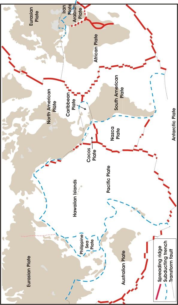
1 Materials Needed: 1. Pencil 2. Colored Pencils 3. Metric/Standard Ruler 4. Calculator 5. Tracing Paper Laboratory #7: Plate Tectonics Plate Tectonics The Earth is composed of layers. At the center is a nickel and iron core, which is separated into a solid inner core and a liquid outer core. Next is the mantle, which is contains the rigid mesosphere, the plastic and ductile asthenosphere, and the rigid upper mantle. The crust and lithosphere are a part of the upper mantle. Plate tectonics has been an accepted theory since the 1960 s. According to this theory, the crust of the Earth is composed of plates that move over the asthenosphere. There are two basic types of plates: heavy, thin and dense oceanic plates, which are primarily composed of basalt; and thick, lighter continental plates, which are comprised of silicate rocks. There are three types of plate boundaries. Divergent plate boundaries (also called spreading centers) occur where two plates are moving away from one another. Convergent plate boundaries exist where two plates are moving towards one another. Convergent plate boundaries are classified based upon the type of crustal plate involved: ocean-ocean, oceancontinent, and continent-continent. Finally, transform plate boundaries are located where two plates are sliding past one another. The largest plate is the Pacific plate, followed by the African plate, Eurasian plate, Australian-Indian plate, Antarctic plate, North American plate, and South American plate. Smaller plates include the Nazca plate, Philippine plate, Caribbean plate, Cocos plate, and Juan de Fuca plate.

2 Most continental shorelines do not coincide with plate boundaries (one important exception is the west coast of South America). Nor are most shorelines zones of earthquake activity. For this reason, continental shorelines are referred to as "passive margins," places that may have been plate boundaries in the past, but are no longer active. The east coast of North America is a passive margin, as are the east, south and west coasts of Africa, northern and Western Europe, and others. The eastern boundary of the North American plate is in the middle of the Atlantic Ocean, where there is a belt of active seismicity. Thus the North American plate is made up of both continent and ocean. In fact, most plates consist of both continental and oceanic material. There are several entirely oceanic plates (Nazca, Cocos), but no entirely continental plates (with the possible exception of the Arabian peninsula; it depends on the criteria one uses to define individual plates and how much ocean is required to be considered "ocean"). The fact that continents are included as part of plates made of both continent and ocean suggests that the continents do not move independently of the oceans as Wegener envisioned, but rather that continent and ocean move together as part of a single plate. Thus from a geodynamical perspective, a "plate" appears to be a more fundamental unit than a continent or ocean.
3 Laboratory #7: Plate Tectonics Part I: Crustal Plates and Plate Boundaries 1. Figure 3 shows the major crustal plates and plate boundaries of Earth. a. Color all of the divergent plate boundaries red, subduction zones blue, continentcontinent convergent boundaries green, and transform faults yellow. b. Shade in areas with chains of volcanoes using a blue pencil. c. Make a key for the colors on your map. d. Next to each plate boundary, place a set of arrows to indicate the relative rate of movement for major plates. 2. How many plates are there? 3. W hich plate is totally surrounded by a convergent plate boundary? 4. Which plate(s) do not contain significant areas of continental landmasses? 5. In general, do continental shorelines coincide with plate boundaries? 6. Are there any plates that have both continents and oceans? If so, name them. 7. List the plates that are bounded in part by: The Mid-Atlantic Ridge: The East Pacific Rise: 8. What major island mass lies on the axis of the Mid-Atlantic Ridge?
4
5 Laboratory #7: Plate Tectonics Part II: Movement of the Volcanoes in the Hawaiian Ridge over the Hawaiian Hot Spot. The premise behind plate tectonics is that the crustal plates are moving with respect to one another over geologic time. The rates of movement of crustal plates can be determined by using data from the plate margins along the mid-ocean ridges, where the amount of movement can be measured. To measure the movement of two adjacent crustal plates along the margins of a divergent plate boundary, two things must be known: 1) two points on adjacent diverging plates that were once at the same geographic coordinates but have since moved away from each other over a known distance; 2) the time required for the two points to move from their original coincident positions to their present positions. Determining the age in actual years of the two points requires knowing the age of the rocks in that location. As new crust forms on either side of a spreading center, this rock becomes magnetized according to the polarity of the Earth at the time of the rocks formation. Thus, if the absolute age of the magnetic anomaly is known, then the age of the rocks in that location are also known. The map of below shows part of the Hawaiian Ridge and the absolute dates of lava in bold black numbers that millions before the present. Hawaii contains an active volcano, Mauna Loa, so the lava from it is zero years old. The lava on Nihoa Island is 7 million years old. Thus, according to the hot spot hypothesis, Nihoa Island was once an active volcano standing where Hawaii stands today. The Lab: Figure the rate in centimeters per year using the distances from Hawaii to each of the three dated lavas on the map located on the next page. Make your distance measurements from the center of the zero on Hawaii to the center of each of the boldface numbers on the ridge.
 4. Do the rates of movement based on the three dates indicate that the movement has been constant or variable? Map of the Hawaiian Ridge in the Pacific Ocean.")
6 Laboratory #7: Plate Tectonics 1. From Hawaii (0 m.y.) to Nihoa Island (7 m.y.) 2. From Nihoa Island (7 m.y.) to just west of Necker Island (10 m.y.) 3. From just west of Necker Island (10 m.y.) to Midway Island (20 m.y.) 4. Do the rates of movement based on the three dates indicate that the movement has been constant or variable? Map of the Hawaiian Ridge in the Pacific Ocean. Contour interval = 1000 meters Scale: 1 cm = 170 km.
7 Laboratory #7: Plate Tectonics Part III: Restoration of the South Atlantic Coastline 50 Million Years before Present Given the evidence of spreading along the Mid-Atlantic Ridge, it can be deduced that the Africa and South America plates are moving away from each other carrying the continents of Africa and South America with them. By using the pattern of magnetic lineations shown on the map on the next page, it is possible to reverse the spreading process and restore the positions of the African and South American coastlines to a time when a particular set of magnetic lineations was being formed on the Mid-Atlantic Ridge. For the purposes of this exercise we win use anomaly number 21, which, according to the magnetic lineation time scale page 51, was formed 49.6 or roughly 50 million years ago. Proceed as follows. 1. On the map on the South Atlantic Ocean, draw a red line over each of the magnetic lineations of anomaly number 21 on the South American side of the Mid-Atlantic Ridge. Connect the segments of the number 21 anomaly with a red line drawn along the fracture zones against which they terminate. Start with the point where anomaly 21 touches the Ascension F. Z. Follow Anomaly 21 with your red pencil southward until it reaches the Bode Verde F. Z., then along the Bode Verde F. Z. westward to the northern end of the next fracture zone. Continue until you have reached the southernmost fracture zone on the map. 2. Attach a piece of tracing paper over the map with tape or paper clips, and repeat the process described above for Anomaly 21 on the African side of the Mid-Atlantic Ridge. Draw this line in red pencil on the tracing paper. 3. With the tracing paper still in place, trace the coastlines of Africa and South America on the tracing paper with black pencil. Also, trace on the tracing paper the boundaries of map and the 20 South latitude line in black pencil. 4. Detach the tracing paper and slide it toward South America until the red line on the tracing paper matches the red line on the map. When the two lines are matched as closely as possible, hold the tracing paper in place and trace the coastline of South America in red pencil on the tracing paper. Trace also the 20 South line on the tracing paper in red pencil. 5. The map you have constructed on the tracing paper shows the Mid-Atlantic Ridge as it existed when magnetic anomaly 21 was being formed. Your tracing paper also shows the relative positions of segments of the coastlines of Africa in black pencil and South America in red pencil as they were approximately 50 million years ago. This reconstruction is based on the assumption that the continents of Africa and South America were fixed to their respective plates during the spreading process over the past 50 million years. The continents moved with respect to each other because the tectonic plates to which they were attached moved as spreading continued along the Mid-Atlantic Ridge. What is the evidence that the movement of the two plates was not strictly in an east-west direction? 6. Was the earth's magnetic field normal or reversed at the time represented by your map on the tracing paper?

8 Laboratory #7: Plate Tectonics Map of the South Atlantic Ocean showing part of the Mid-Atlantic Ridge in black bars, with east-west fracture zones, and selected m agnetic anom alies. The ages of the num bered anom alies or m agnetic lineations can be determ ined from the m agnetic tim e scale in the next page. (From Magnetic Lineations of the W orld s Ocean Basins, Copyright 1985 the Am erican Association of Petroleum Geologists.
9 Marine magnetic anomalies. (A) The black line shows positive anomalies as recorded by a magnetometer towed behind a ship. In the cross section of the oceanic crust, positive anomalies are drawn as black bars and negative anomalies are drawn as white bars. (B) Perspective view of magnetic anomalies shows that they are parallel to the rift valley and symmetric about the ridge crest. Magnetic Time Scale. Magnetic anomaly identification numbers are given on the top and absolute time scale in millions of years (Ma) is given on the bottom. Normal magnetic anomalies are shown in black, and reversed polarity is shown in white. The absolute age of the anomalies and their polarities can be read directly from the chart. For example, anomaly 4 is 7 million years old, and it is a positive anomaly.
With a group, get a bar magnet, some plastic wrap, iron filings and a compass.
 Name: EPS 50 Lab 8: The Earth's Magnetic Field Chapter 2, p. 39-41: The Seafloor as a Magnetic Tape Recorder Chapter 7, p. 213: Paleomagnetic Stratigraphy Chapter 14, p. 396-406: Earth s Magnetic Field
12. The diagram below shows the collision of an oceanic plate and a continental plate.
 Review 1. Base your answer to the following question on the cross section below, which shows the boundary between two lithospheric plates. Point X is a location in the continental lithosphere. The depth
6. In the diagram below, letters A and B represent locations near the edge of a continent.
 1. Base your answer to the following question on the cross section below and on your knowledge of Earth science. The cross section represents the distance and age of ocean-floor bedrock found on both sides
A) B) C) D) 4. Which diagram below best represents the pattern of magnetic orientation in the seafloor on the west (left) side of the ocean ridge?
 B) C) D) 4. Which diagram below best represents the pattern of magnetic orientation in the seafloor on the west (left) side of the ocean ridge?") 1. Crustal formation, which may cause the widening of an ocean, is most likely occurring at the boundary between the A) African Plate and the Eurasian Plate B) Pacific Plate and the Philippine Plate C)
1. Crustal formation, which may cause the widening of an ocean, is most likely occurring at the boundary between the A) African Plate and the Eurasian Plate B) Pacific Plate and the Philippine Plate C)
Practice Questions: Plate Tectonics
 Practice Questions: Plate Tectonics 1. Base your answer to the following question on The block diagram below shows the boundary between two tectonic plates. Which type of plate boundary is shown? A) divergent
Dynamic Earth Quiz. 4. The accompanying diagram shows some features of Earth s crust and upper mantle.
 DO NOT WRITE ON THIS Dynamic Earth Quiz DO NOT WRITE ON THIS 1. Base your answer(s) to the following question(s) on the diagram below. The diagram shows a model of the relationship between Earth s surface
Crustal Boundaries. As they move across the asthenosphere and form plate boundaries they interact in various ways. Convergent Transform Divergent
 Name: Date: Period: Plate Tectonics The Physical Setting: Earth Science CLASS NOTES Tectonic plates are constantly moving and interacting As they move across the asthenosphere and form plate boundaries
Chapter. Graphics by Tasa Graphic Arts. Inc.
 Earth Chapter Plate Science 9 Tectonics Graphics by Tasa Graphic Arts. Inc. 1 I. Earth s surface is made up of lithospheric plates. A. Lithospheric plates are composed of the crust and part of the upper
Dynamic Crust Practice
 1. Base your answer to the following question on the cross section below and on your knowledge of Earth science. The cross section represents the distance and age of ocean-floor bedrock found on both sides
An Introduction to the Seafloor and Plate Tectonics 1
 An Introduction to the Seafloor and Plate Tectonics 1 Objectives 1) Investigate the components of the lithosphere and lithospheric plates. 2) Identify the associations among various seafloor features,
1. List the 3 main layers of Earth from the most dense to the least dense.
 1. List the 3 main layers of Earth from the most dense to the least dense. 2. List the 6 layers of earth based on their physical properties from the least dense to the most dense. 3. The thinnest layer
Dynamic Earth A B1. Which type of plate boundary is located at the Jordan Fault? (1) divergent (3) convergent (2) subduction (4) transform
 divergent (3) convergent (2) subduction (4) transform") Dynamic Earth A B1 1. The edges of most lithospheric plates are characterized by (1) reversed magnetic orientation (2) unusually rapid radioactive decay (3) frequent volcanic activity (4) low P-wave and
Dynamic Earth A B1 1. The edges of most lithospheric plates are characterized by (1) reversed magnetic orientation (2) unusually rapid radioactive decay (3) frequent volcanic activity (4) low P-wave and
Lab 1: Plate Tectonics April 2, 2009
 Name: Lab 1: Plate Tectonics April 2, 2009 Objective: Students will be introduced to the theory of plate tectonics and different styles of plate margins and interactions. Introduction The planet can be
Plate Tectonics Introduction
 Name Block Plate Tectonics Introduction Go to the following site: http://www.learner.org/interactives/dynamicearth/index.html On the top of the screen are different tabs, click on each section as listed
CHAPTER 2 THE WAY THE EARTH WORKS: EXAMINING PLATE TECTONICS
 CHAPTER 2 THE WAY THE EARTH WORKS: EXAMINING PLATE TECTONICS Coverage of plate tectonics is required early in introductory Geology as context for the mineralogy, petrology, structure, internal processes,
The Four Layers The Earth is composed of four different layers. The crust is the layer that you live on, and it is the most widely studied and
 Earth s Structure The Four Layers The Earth is composed of four different layers. The crust is the layer that you live on, and it is the most widely studied and understood. The mantle is much hotter and
10/27/2014. Before We Begin, You Need to Understand These Terms: Earth s Structural Key Elements & the Hazards of Plate Movement
 Earth s Structural Key Elements & the Hazards of Plate Movement Before We Begin, You Need to Understand These Terms: Density Convection Currents AICE EM: Lithosphere Key Content 1 & 2 Density: heat rises,
Unit: 4 Plate Tectonics LT 4.1 Earth s Interior: I can draw and interpret models of the interior of the earth.
 Unit: 4 Plate Tectonics LT 4.1 Earth s Interior: I can draw and interpret models of the interior of the earth. 1. Can you draw the 3-layer model and the 5-layer model of the Earth? #1 Yes I can: 2. Can
Earth s Interior StudyGuide
 Name Date Period Earth s Interior StudyGuide 1. The two main elements that make up the Earth s crust are and. 2. The Earth s inner core is made of solid and. 3. When one plates slides under another plate
1. I can describe evidence for continental drift theory (e.g., fossil evidence, mountain belts, paleoglaciation)
") Science 10 Review Earth Science Vocabulary asthenosphere continental drift theory converging plates diverging plates earthquakes epicentre fault hot spot inner core lithosphere mantle mantle convection
Science 10 Review Earth Science Vocabulary asthenosphere continental drift theory converging plates diverging plates earthquakes epicentre fault hot spot inner core lithosphere mantle mantle convection
The Theory of Plate Tectonics Name
 The Theory of Plate Tectonics Name Intermediate Version Block CHAPTER 1 INTRODUCTION 1. The scientific theory that describes the movement of Earth s outer layer is called. CHAPTER 2 CONTINENTAL DRIFT:
5. Convergent boundaries produce a relatively low number of earthquakes compared to other boundaries. a. True
 1. Earth s crust is thinner than its mantle. ANSWER: True 2. The concept of isostacy states that high-density rock will stand higher than low-density rock, which explains the formation of subduction zones.
is a unifying theme in modern geology that integrates the earlier ideas of
 The concept of Global Plate Tectonics is a unifying theme in modern geology that integrates the earlier ideas of continental drift, sea-floor spread, and mountain building To explain why the present ocean
FORCES ON EARTH UNIT 3.2. An investigation into how Newton s Laws of Motion are applied to the tectonic activity on Earth.
 FORCES ON EARTH UNIT 3.2 An investigation into how Newton s Laws of Motion are applied to the tectonic activity on Earth. USE THESE NOTES: OUR HOME PLANET EARTH: What do you know about our planet? SO.HOW
Lecture 4.1 Continental Drift
 Plate Tectonics Chapter 4 California Science Content Standards Covered: Big Ideas 3A: Students know the features of the ocean floor that provide evidence of plate tectonics Mid Ocean Ridges (ex. Mid Atlantic
Plate Tectonics Tutoiral. Questions. Teacher: Mrs. Zimmerman. Plate Tectonics and Mountains Practice Test
 Teacher: Mrs. Zimmerman Print Close Plate Tectonics and Mountains Practice Test Plate Tectonics Tutoiral URL: http://www.hartrao.ac.za/geodesy/tectonics.html Questions 1. Fossils of organisms that lived
Continental Drift and Plate Tectonics
 Continental Drift and Plate Tectonics Continental Drift Wegener s continental drift hypothesis stated that the continents had once been joined to form a single supercontinent. Wegener proposed that the
UNIT 6 PLATE TECTONICS
 UNIT 6 PLATE TECTONICS CONTINENTAL DRIFT Alfred Wegner proposed the theory that the crustal plates are moving over the mantle. He argued that today s continents once formed a single landmass, called Pangaea
Earth s Tectonic Plates
 MASTER 49 6.2 3.7 5.4 Philippine Pacific 5.4 North American Juan de Fuca Caribbean Cocos 10.0 9.2 2.3 2.5 2.3 1.8 3.0 Indian-Australian 10.5 7.1 17.2 16.8 6.0 Nazca South American 11.1 10.3 7.3 3.7 7.5
Unit Topics. Topic 1: Earth s Interior Topic 2: Continental Drift Topic 3: Crustal Activity Topic 4: Crustal Boundaries Topic 5: Earthquakes
 The Dynamic Earth Unit Topics Topic 1: Earth s Interior Topic 2: Continental Drift Topic 3: Crustal Activity Topic 4: Crustal Boundaries Topic 5: Earthquakes Topic 1: Earth s Interior Essential Question:
PHYSICAL GEOLOGY AND THE ENVIRONMENT (2 ND CANADIAN EDITION)
") Chapter 2: Plate Tectonics Chapter Summary: Plate tectonics is a theory that suggests Earth's surface is divided into several large plates that change position and size. Intense geologic activity occurs
Chapter 2: Plate Tectonics Chapter Summary: Plate tectonics is a theory that suggests Earth's surface is divided into several large plates that change position and size. Intense geologic activity occurs
In 1912 Alfred Wegener proposed Continental Drift the continents have moved over time the continents were part of one giant landmass named Pangaea.
 Plate Tectonics In 1912 Alfred Wegener proposed Continental Drift the continents have moved over time the continents were part of one giant landmass named Pangaea. Pangaea Landmass movements over millions
Plate Tectonics. I. The Discovery of Plate Tectonics II. A Mosaic of Plates III. Types of Plate Boundaries IV. How Plates Move
 Plate Tectonics I. The Discovery of Plate Tectonics II. A Mosaic of Plates III. Types of Plate Boundaries IV. How Plates Move I. The Discovery of Plate Tectonics A. Continental Drift (Alfred Wegener) Proposed
Earth and Space Science Semester 2 Exam Review. Part 1. - Convection currents circulate in the Asthenosphere located in the Upper Mantle.
 Earth and Space Science 2015 Semester 2 Exam Review Part 1 Convection -A form of heat transfer. - Convection currents circulate in the Asthenosphere located in the Upper Mantle. - Source of heat is from
Full file at
 Chapter 2 PLATE TECTONICS AND PHYSICAL HAZARDS MULTIPLE-CHOICE QUESTIONS 1. What direction is the Pacific Plate currently moving, based on the chain of Hawaiian Islands with only the easternmost island
Plate Tectonics. The Theory of Plate Tectonics. The Plate Tectonics Theory. 62 Plate Tectonics Reading Essentials
 CHAPTER 4 LESSON 3 Tectonics The Theory of Tectonics Key Concepts What is the theory of plate tectonics? What are the three types of plate boundaries? Why do tectonic plates move? What do you think? Read
Plate Tectonics. entirely rock both and rock
 Plate Tectonics I. Tectonics A. Tectonic Forces are forces generated from within Earth causing rock to become. B. 1. The study of the origin and arrangement of Earth surface including mountain belts, continents,
83% 25 of 30 Correct. Dynamic Earth Assessment Test Results. Name: Marc Sto. Domingo Date: October 2, 2013
 Dynamic Earth Assessment Test Results Name: Marc Sto. Domingo Date: October 2, 2013 83% 25 of 30 Correct Review the questions and your answers below. The answer you selected is highlighted in red, the
PSc 201 Chapter 3 Homework. Critical Thinking Questions
 PSc 201 Chapter 3 Homework Critical Thinking Questions 1. (adapted from text) Seawater is denser than fresh water. A ship moving from the Atlantic Ocean into the Great Lakes goes from seawater to fresh
EARTH S INTERIOR, EVIDENCE FOR PLATE TECTONICS AND PLATE BOUNDARIES
 EARTH S INTERIOR, EVIDENCE FOR PLATE TECTONICS AND PLATE BOUNDARIES LAYERS OF THE EARTH Crust Inner Core Most Dense Solid Iron & Nickel Mantle Thickest layer Outer Core Liquid Iron & Nickel ANOTHER LOOK
Core. Crust. Mesosphere. Asthenosphere. Mantle. Inner core. Lithosphere. Outer core
 Potter Name: Date: Hour: Score: /21 Learning Check 4.1 LT 4.1 Earth s Interior: I can draw and interpret models of the interior of the earth. Draw the following models (put the words in the right order)
Lecture Outline Friday January 12 Friday January 19, 2018
 Lecture Outline Friday January 12 Friday January 19, 2018 Questions?? Key Points for today The structure of the Earth Introduction to Plate Tectonic Theory and Convection Chapter 2 Development of the Plate
Seafloor Spreading and Paleomagnetism Activity
 Name: PART A: Ocean Bottom Profile Background: Seafloor spreading is the hypothesis that the sea floor moves sideways away from the crest of the mid- ocean ridge. It is estimated that 20 volcanic eruptions
Earth is over 1200 km thick and has four distinct layers.
 1 2.2 F e a ture s o f P la te T e c to nic s Earth is over 1200 km thick and has four distinct layers. These layers are the crust, mantle (upper and lower), outer core, and inner core. Crust outer solid
Plate Tectonics. What is a theory? What is a fact? In science, a theory is an explana4on, with evidence, that can be tested.
 What is a theory? Plate Tectonics In science, a theory is an explana4on, with evidence, that can be tested. What is a fact? Informa4on that cannot be argued. Plate Tectonics Plate Tectonics The theory
Crustal Activity. Plate Tectonics - Plates - Lithosphere - Asthenosphere - Earth s surface consists of a major plates and some minor ones
 Name: Date: Period: Tectonics The Physical Setting: Earth Science CLASS NOTES Tectonics - s - Lithosphere - Asthenosphere - Earth s surface consists of a major plates and some minor ones The plates are
What Forces Drive Plate Tectonics?
 What Forces Drive Plate Tectonics? The tectonic plates are moving, but with varying rates and directions. What hypotheses have been proposed to explain the plate motion? Convection Cells in the Mantle
22.4 Plate Tectonics. Africa
 The Red Sea between Africa and the Arabian peninsula in Asia marks a region where two pieces of the lithosphere are slowly moving apart. Over the next 100 million years, the Red Sea could become an ocean.
12.2 Plate Tectonics
 12.2 Plate Tectonics LAYERS OF THE EARTH Earth is over 1200 km thick and has four distinct layers. These layers are the crust, mantle (upper and lower), outer core, and inner core. Crust outer solid rock
In order to study Plate Tectonics, we must first
 TB Chapter 13 In order to study Plate Tectonics, we must first reorganize our layering system for the Earth: Old System 4 layers Crust (rigid) id) (rigid) Mantle (putty like) (semi rigid) Outer core (liquid)
Seafloor spreading is a geologic process in which tectonic plates large slabs of Earth's lithosphere split apart from each other.
 This website would like to remind you: Your browser (Apple Safari 4) is out of date. Update your browser for more security, comfort and the best experience on this site. Encyclopedic Entry seafloor spreading
USU 1360 TECTONICS / PROCESSES
 USU 1360 TECTONICS / PROCESSES Observe the world map and each enlargement Pacific Northwest Tibet South America Japan 03.00.a1 South Atlantic Arabian Peninsula Observe features near the Pacific Northwest
Evidence from the Surface. Chapter 02. Continental Drift. Fossil Evidence for Pangaea. Seafloor Spreading. Seafloor Spreading 1/31/2012
 Evidence from the Surface Surface landforms Continental shelf and slope Abyssal Plane Mid-oceanic ridge Oceanic Trenches Chapter 02 Continental Drift Continental Drift - a hypothesis that the continents
OS 1 The Oceans Fall 2007
 Name: Plate Tectonics (you must turn Activities 1-2 in during Section) Activity 1: Plate Boundaries A plate boundary simply describes where two plates (either oceanic or continental material) meet. There
* If occurs, fossils that formed in shallow water may be found in water. Subsidence mean the crust is.
 Name Notes: Topic 5B Topic 5B: The Dynamic Crust A. What evidence exists that proves the Earth s Crust is and has moved? Earth Science 1. Tilted, folded or faulted strata Strata is a term that refers to.
Plate Tectonics: A Scientific Revolution Unfolds
 Chapter 2 Lecture Earth: An Introduction to Physical Geology Eleventh Edition Plate Tectonics: A Scientific Revolution Unfolds Tarbuck and Lutgens From Continental Drift to Plate Tectonics Prior to the
PLATE TECTONICS REVIEW GAME!!!!
 PLATE TECTONICS REVIEW GAME!!!! Name the four layers of the earth - crust - mantle - outer core - inner core Which part of Earth s structure contains tectonic plates? LITHOSPHERE Name one reason why the
Science 10 PROVINCIAL EXAM STUDY BOOKLET. Unit 4. Earth Science
 Science 10 PROVNCAL EXAM STUDY BOOKLET Unit 4 Earth Science Student nstructions 1. Ensure that you have blank paper and a Data Booklet. 2. Record all answers on a separate piece of paper. 3. Answer keys
Assembly Instructions:
 Assembly Instructions: Materials: - One 12 x 18 pieces of construction paper - Scissors and Glue 1. Fold Paper in Half 2. Cut in half & fold into fourths 3. Attach or draw a cover page on the front part
Prentice Hall EARTH SCIENCE
 Prentice Hall EARTH SCIENCE Tarbuck Lutgens Chapter 9 Plate Tectonics 9.1 Continental Drift An Idea Before Its Time Wegener s continental drift hypothesis stated that the continents had once been joined
Prentice Hall EARTH SCIENCE
 Prentice Hall EARTH SCIENCE Tarbuck Lutgens Chapter 9 Plate Tectonics 9.1 Continental Drift An Idea Before Its Time Wegener s continental drift hypothesis stated that the continents had once been joined
Lab 2: Plate tectonics
 Geology 101 Name(s): Lab 2: Plate tectonics Plate tectonics is the theory that is used to explain geological phenomena worldwide. For this reason, most of the useful maps that illustrate plate tectonics
Ch 9.1 Notes. Objective: Be able to explain the theory of plate tectonics and be able to explain evidence that supports it.
 Ch 9.1 Notes Objective: Be able to explain the theory of plate tectonics and be able to explain evidence that supports it. Pangaea Alfred Wegener proposed that land on Earth formed a single, huge landmass.
Plate Tectonics: The New Paradigm
 Earth s major plates Plate Tectonics: The New Paradigm Associated with Earth's strong, rigid outer layer: Known as the lithosphere Consists of uppermost mantle and overlying crust Overlies a weaker region
FORCES ON EARTH. An investigation into how Newton s Laws of Motion are applied to the tectonic activity on Earth.
 FORCES ON EARTH An investigation into how Newton s Laws of Motion are applied to the tectonic activity on Earth. GEOLOGY Geologists scientists who study the forces that make and shape the Earth Geologists
Continental Drift. & Plate Tectonics
 Continental Drift & Plate Tectonics Alfred Wegener, a German scientist, proposed the hypothesis of CONTINENTAL DRIFT, in 1912. Hypothesis stated: All Earth s continents were once a single landmass (Pangaea)
Unit 11: Plate Tectonics
 Unit 11: Plate Tectonics A. Alfred Wegner 1. Continental drift hypothesis a. single supercontinent called Pangaea b. 200 million years ago Pangaea (all land) began to break up and started drifting to their
Module 7: Plate Tectonics and Earth's Structure Topic 2 Content: Plates of the World Presentation Notes
 There are several large plates and several smaller plates that comprise the Earth s crust. How do these plates interact with the bordering plates? Review each of the world s plates and the landforms that
Ch. 9 Review. Pgs #1-31 Write Questions and Answers
 Ch. 9 Review Pgs. 356-357 #1-31 Write Questions and Answers 356-357 #1-5 Answers 1. The layer of the upper mantle that can flow is the: A - Asthenosphere 2. Most scientists rejected Wegener s theory of
Features of Tectonic Plates
 Features of Tectonic Plates PowerPoint 12.2 The Earth s Layers Crust Brittle Continental crust composed mainly of granite Oceanic crust composed mainly of basalt Mantle Denser than the crust Upper is molten
3. PLATE TECTONICS LAST NAME (ALL IN CAPS): FIRST NAME: PLATES
: FIRST NAME: PLATES") LAST NAME (ALL IN CAPS): FIRST NAME: PLATES 3. PLATE TECTONICS The outer layers of the Earth are divided into the lithosphere and asthenosphere. The division is based on differences in mechanical properties
LAST NAME (ALL IN CAPS): FIRST NAME: PLATES 3. PLATE TECTONICS The outer layers of the Earth are divided into the lithosphere and asthenosphere. The division is based on differences in mechanical properties
ANOTHER MEXICAN EARTHQUAKE! Magnitude 7.1, Tuesday Sept. 19, 2017
 ANOTHER MEXICAN EARTHQUAKE! Magnitude 7.1, Tuesday Sept. 19, 2017 Why is there no oceanic crust older than 200 million years? SUBDUCTION If new oceanic crust is being continuously created along the earth
Name Test Date Hour. the interior of the Earth to the surface. younger less dense plate.
 Name Test Date Hour Earth Processes#2 - Notebook Plate Tectonics LEARNING TARGETS I can identify and describe the three main layers of Earth. I can explain the difference between an oceanic and a continental
Notepack # 9 AIM: Why are the continents drifting apart? Do Now: Watch the video clip and write down what you observe.
 Notepack # 9 AIM: Why are the continents drifting apart? Do Now: Watch the video clip and write down what you observe. http://www.youtube.com/watch?v=ci 5P5yy0xlg&feature=related What do we know as a class,
Week: 4 5 Dates: 9/8 9/12 Unit: Plate Tectonics
 clementaged.weebly.com Name: ODD Period: Week: 4 5 Dates: 9/8 9/12 Unit: Plate Tectonics Monday Tuesday Wednesday Thursday Friday 7 No School 8 E 9 O *Vocabulary *Frayer Vocab *Continental Drift Notes
THE INTERNAL STRUCTURE OF THE EARTH
 UNIT 1 THE INTERNAL STRUCTURE OF THE EARTH 1.1.Earth s interior layers The interior of the Earth can be divided into layers according to: -Composition layers ( organized in order of increasing density
Sir Francis Bacon, 1620, noted that the continental coasts on opposites sides of the Atlantic fit together like puzzle pieces.
 Plate Tectonics Sir Francis Bacon, 1620, noted that the continental coasts on opposites sides of the Atlantic fit together like puzzle pieces. Could North and South America once have been joined to Europe
Plate Tectonics AGS 371
 Name(s) Date Period Instructions Plate Tectonics AGS 371 This lab utilizes the CD The Theory of Plate Tectonics (Advanced). The lab consists of a number of questions and diagrams regarding the development
60% water. Big Bang: 14,000 millions years ago The Earth originated about 4,500 millions years ago its orbit allows water to exist in a liquid state!
 Ch2. The Sea Floor #1 Why geology of the oceans? Marine habitats are directly shaped by geological processes The form of the coastlines The depth of the water Type of bottom (muddy, sandy, rocky) #2 Geological
Chapter Two. Figure 02_02. Geography of the Ocean Basins. The Sea Floor
 Chapter Two The Sea Floor Geography of the Ocean Basins Figure 02_02 The world ocean is the predominant feature on the Earth in total area. In the Northern Hemisphere, 61% of the total area is ocean. In
Kind of plate boundary (convergent or divergent?)
") 19B Plate Tectonics What is plate tectonics? Earth s crust plus the upper mantle forms the lithosphere. Earth s lithosphere is broken in a number of different pieces. How these pieces move and interact
19B Plate Tectonics What is plate tectonics? Earth s crust plus the upper mantle forms the lithosphere. Earth s lithosphere is broken in a number of different pieces. How these pieces move and interact
Beneath our Feet: The 4 Layers of the Earty by Kelly Hashway
 Beneath our Feet: The 4 Layers of the Earty by Kelly Hashway The Earth is more than a giant ball made up of dirt, rocks, and minerals. The Earth may look like a giant ball from when looking at it from
UNIT 11 PLATE TECTONICS
 UNIT 11 PLATE TECTONICS A. ALFRED WEGENER 1. Continental drift hypothesis Single supercontinent called Pangaea 200 million years ago Pangaea (all land) began to break up and started drifting to their present
Lab 7: Plate tectonics
 Geology 115/History 150 Name(s): Lab 7: Plate tectonics Plate tectonics is the theory that is used to explain geological phenomena worldwide. For this reason, most of the useful maps that illustrate plate
The Structure of the Earth and Plate Tectonics
 The Structure of the Earth and Plate Tectonics Structure of the Earth The Earth is made up of 4 main layers: Inner Core Outer Core Mantle Crust Crust Mantle Outer core Inner core The Crust This is where
Full file at
 Essentials of Oceanography, 10e (Trujillo/Keller) Chapter 2 Plate Tectonics and the Ocean Floor Match the term with the appropriate phrase. You may use each answer once, more than once or not at all. A)
Distribution of Continents Mid-ocean Ridges Trenches. Deformation Metamorphism Volcanism Earthquakes
 Earthquakes and Plate Tectonics Global Problems in Geology Distribution of Continents Mid-ocean Ridges Trenches Orogenic Belts Deformation Metamorphism Volcanism Earthquakes Development of Continental
Chapter 2 Plate Tectonics and the Ocean Floor
 Chapter 2 Plate Tectonics and the Ocean Floor Matching. Match the term or person with the appropriate phrase. You may use each answer once, more than once or not at all. 1. hydrothermal vents A. convergent
LAB: PLATE TECTONICS GOAL: Calculate rates of plate movement
 Name LAB: PLATE TECTONICS GOAL: Calculate rates of plate movement Rates of plate movement are calculated by measuring the distance rocks have moved since they formed. Rates are expressed in cm per year
1. What is Wegener s theory of continental drift? 2. What were the 4 evidences supporting his theory? 3. Why wasn t Wegener s theory excepted?
 Notebook 7a and 7b Objective (left-side): Students will be able to explain the theory of plate tectonics and be able to make predictions about plate interactions. Mapping Reflection 1. What is Wegener
Directed Reading. Section: The Theory of Plate Tectonics. to the development of plate tectonics, developed? HOW CONTINENTS MOVE
 Skills Worksheet Directed Reading Section: The Theory of Plate Tectonics 1. The theory that explains why and how continents move is called. 2. By what time period was evidence supporting continental drift,
Plate Tectonics CHAPTER 17
 Plate Tectonics CHAPTER 17 Layers of the Earth A. Crust- solid, 5-70 km thick Moho Two Types of Crust: Oceanic- ocean floor, more dense then because of more iron Continental-dry land (mostly silicates
Outcome C&D Study Guide
 Name: Class: Outcome C&D Study Guide Identify the layers of Earth s interior Lithosphere the upper most layer of the earth that includes the crust and the hard outer mantle. It is fractured into tectonic
Chapter 02 The Sea Floor
 Chapter 02 The Sea Floor Multiple Choice Questions 1. One of the following is not one of the world's major ocean basins: A. Atlantic Ocean B. Arctic Ocean C. Indian Ocean D. Antarctic Ocean E. Pacific
Define plate tectonics. Explain what the word tectonic means as part of your definition.
 Lesson 3 The Theory of Tectonics LA.7.2.2.3, MA.6.A.3.6, SC.7.E.6.4, SC.7.E.6.5, SC.7.E.6.7, SC.7.N.1.1, SC.7.N.1.5, SC.7.N.1.6 Skim or scan the heading, boldfaced words, and pictures in the lesson. Identify
Name Date Class. How have geologists learned about Earth s inner structure? What are the characteristics of Earth s crust, mantle, and core?
 Chapter 4 Plate Tectonics Section 1 Summary Earth s Interior How have geologists learned about Earth s inner structure? What are the characteristics of Earth s crust, mantle, and core? Earth s surface
Introduction To Plate Tectonics Evolution. (Continents, Ocean Basins, Mountains and Continental Margins)
") Introduction To Plate Tectonics Evolution (Continents, Ocean Basins, Mountains and Continental Margins) Geo 386 (Arabian Shield Course) Dr. Bassam A. A. Abuamarah Mohanna G E O 3 8 6 A R A B I A N G E
Introduction To Plate Tectonics Evolution (Continents, Ocean Basins, Mountains and Continental Margins) Geo 386 (Arabian Shield Course) Dr. Bassam A. A. Abuamarah Mohanna G E O 3 8 6 A R A B I A N G E
Question. Question. Question. Question. What are the topics of our last class? is the tendency of some minerals to break along flat surfaces?
 Question What are the topics of our last class? Question is the tendency of some minerals to break along flat surfaces? A. Crystal habit; B. Cleavage; C. Fracture; D. Hardness Question Calcite is a mineral.
Plate Tectonics. Essentials of Geology, 11 th edition Chapter 15
 1 Plate Tectonics Essentials of Geology, 11 th edition Chapter 15 2 3 4 5 6 7 8 9 10 11 12 13 14 15 Plate Tectonics: summary in haiku form Alfred Wegener gave us Continental Drift. Fifty years later...
TAKE HOME EXAM 8R - Geology
 Name Period Date TAKE HOME EXAM 8R - Geology PART 1 - Multiple Choice 1. A volcanic cone made up of alternating layers of lava and rock particles is a cone. a. cinder b. lava c. shield d. composite 2.