of Pennsylvanian Marine Shale Beds from the Central Appalachian and Eastern Interior Basins
|
|
|
- Rolf Bond
- 6 years ago
- Views:
Transcription
1 Comparative 2014 Eastern Unconventional Oil and Organic Gas Symposium - November 5-7, 2014 in Petrography Lexington, Kentucky, USA of Pennsylvanian Marine Shale Beds from the Central Appalachian and Eastern Interior Basins Cortland F. Eble Stephen F. Greb Kentucky Geological Survey University of Kentucky Lexington, Kentucky USA
2 Investigation Goals Evaluate the organic composition of Pennsylvanian age marine shale units that occur in the Central Appalachian and Eastern Interior (Illinois) Basins. Total organic matter (TOC) content Maceral composition Level of thermomaturation Comment on the similarities and differences in shale bed composition from these two areas. Special Thanks! Alliance Coal LLC USGS
3 Eastern Interior (Illinois) Basin Study Areas IL PA IN OH MD WV KY VA NC TN Central Appalachian Basin
4 Basin Structure IL KY Illinois Basin Western Kentucky Coal Field IN IN IL KY aa aa aa scale 20 mi 30 km N OH KY bb OH WV Eastern Kentucky Coal Field WV VA Springfield coal structure elevation (m) > to to -150 < to -300 KY TN Fire Clay coal structure elevation (m) VA bb bb Central Appalachian Basin From Greb et al (2002)
5 Basin Structure Illinois Basin Central Appalachian Basin W E NW SE aa aa aa bb bb bb Caseyville Fm Tradewater Fm Carbondale Fm McLeansboro Group Conemaugh Fm Princess Fm Four Corners Fm Hyden Fm Pikeville Fm Corbin Ss Grundy Fm WS RCFS 150 m 500 ft 40 mi 60 km Bee Rock Ss Sewanee Ss WF IPFS Warren Point Ss Alvy Creek Fm Bottom Creek Fm Stephanian Westphalian D Bolsovian (Wes. C) Duckmantian (Wes. B) Langsettian (Wes. A) Namurian B/C EKS Langsettian/Namurian quartzarenites Pocahontas Fm From Greb et al (2002) Illinois Basin is a cratonic interior sag basin Central Appalachian Basin is part of a foreland basin

6 Central Appalachian Basin Core Location KY WV VA CBM Test Well 26 samples Shale Sample Well 11 samples TN
7 Lower Pennsylvanian Series Pocahontas Formation Pocahontas Formation Lee Formation New River Formation Bottom CrK. Formation Alvy Crk. Fm Core Interval Norton Formation 1000 m in SWVA Wise Fm Kanawha Formation (part) Grundy Formation SWVA SWV EKY SW Virginia S. West Virginia Eastern Kentucky Clintwood Blair Dorchester Gladeville SS Hagy Splash Dam Upper Banner Lower Banner Kennedy Naese SS Bee Rock SS Jawbone Tiller U. Seaboard Greasy Creek M. Seaboard L. Seaboard Upper Horsepen Middle Horspen War Creek Pocahontas #9 Pocahontas #8 Pocahontas #7 Pocahontas #6 Pocahontas #5 Pocahontas #4 Pocahontas #3 Pocahontas #2 Pocahontas #1 Squire Jim Matewan Eagle Bens Creek Little Eagle Lower War Eagle Glenalum Tunnel Gilbert A Gilbert Douglas Nuttall SS (upper) Nuttall SS ( lower) Iaeger Lower Iaeger Castle Sewell B Sewell A Sewell Welch Little Raleigh Beckley Little Fire Creek Pocahontas #8 Pocahontas #7 Pocahontas #6 Pocahontas #5 Pocahontas #4 Pocahontas #3 Pocahontas #2 Pocahontas #1 Squire Jim Clintwood Millard Glamorgan Little Eagle Hagy Splash Dam Elswick Upper Banner Lower Banner Naese sandstone Bee Rock sandstone Tunnel Stearns #3* Stearns #2* Livingston* Cumberland Gap* Section absent in EKY *correlations uncertain
8 Jawbone 1 Jawbone 3 Tiller Upper Seaboard A? Greasy Creek Lower Seaboard 1&2 Lower Seaboard 1&2 Lower Seaboard 3 Upper Horsepen Upper Horsepen Middle Horsepen War Creek (P11) War Creek (P11) Pocahontas #9 Pocahontas #9 Pocahontas #8 Pocahontas #8, L-1 Pocahontas #8, L 2 Pocahontas #7 Pocahontas #7 Pocahontas #6.5 Pocahontas #6 Pocahontas #5 Pocahontas #4 Pocahontas #4 Leader Pocahontas #3 Pocahontas #2 SW Virginia Core Samples Coal Thickness ft avg. = 1.4 ft max. = 2.2 ft min. = 0.5 ft
9 Coal Beds Jawbone 1 Jawbone 3 Tiller U. Seaboard A Greasy Creek L. Seaboard 1 L. Seaboard 2 L. Seaboard 3 U. Horsepen 1 U. Horsepen 2 M. Horsepen War Creek Pocahontas #9 Pocahontas #9 Pocahontas #8 Pocah. #8 L1 Pocah. #8 L2 Pocahontas #7 Pocahontas #7 Pocahontas #6.5 Pocahontas #6 Pocahontas #5 Pocahontas #4 Pocahontas #4L Pocahontas #3 Pocahontas #2 SW Virginia Coal Samples Maceral Composition COAL % mineral matter-free basis avg. max. min. Vitrinite TV DV + GV Liptinite Inertinite Vitrinite, mmf Liptinite, mmf Inertinite, mmf
10 Coal Bed Jawbone 1 Jawbone 3 Tiller U. Seaboard A Greasy Creek L. Seaboard 1 L. Seaboard 2 L. Seaboard 3 U. Horsepen 1 U. Horsepen 2 M. Horsepen War Creek Pocahontas #9 Pocahontas #9 Pocahontas #8 Pocah. #8 L1 Pocah. #8 L2 Pocahontas #7 Pocahontas #7 Pocahontas #6.5 Pocahontas #6 Pocahontas #5 Pocahontas #4 Pocahontas #4L Pocahontas #3 Pocahontas #2 SW Virginia Coal Samples Ro maximum, % % Ro maximum Average 1.10 Maximum 1.23 Minimum 0.98
11 Coal Beds Jawbone 1 Jawbone 3 Tiller U. Seaboard A Greasy Creek L. Seaboard 1 L. Seaboard 2 L. Seaboard 3 U. Horsepen 1 U. Horsepen 2 M. Horsepen War Creek Pocahontas #9 Pocahontas #9 Pocahontas #8 Pocah. #8 L1 Pocah. #8 L2 Pocahontas #7 Pocahontas #7 Pocahontas #6.5 Pocahontas #6 Pocahontas #5 Pocahontas #4 Pocahontas #4L Pocahontas #3 Pocahontas #2 SW Virginia Coal Samples Gas Content Scf/ton (as-received basis) average 286 maximum 452 minimum 111


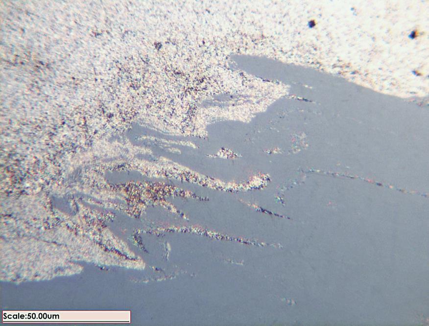

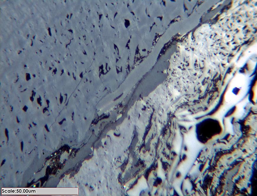
12 White Light White Light
13 Orthoquartzites Breathitt Group Stratigraphy Major marine transgressive cycles Coal-clastic cycles (cycolthem equivalents) Corbin Ss Bee Rock Ss (Pine Creek Ss + Rockcastle Ss) Sewanee Ss Warren Point Ss C BR Se Wp Stoney Fork Magoffin Kendrick Betsie Dave Branch* Hensley* Dark Ridge* Princess Fm. 4 Corners Fm. Hyden Fm. Pikeville Fm. Grundy Fm. Alvy Ck. Fm. Bottom Ck. Fm. Pocahontas Fm. Middle Pennsylvanian Lower Pennsylvanian D C B Westphalian A 1350 m 650 m Laterally extensive marine shales Stratigraphic framework of Chesnut (1988, 1992)
14 Russell County, Virginia Shale Samples Total Organic Carbon, % (ft) Depth Dave Branch Shale Member Hensely Shale Member Dark Ridge Shale Member
15 SW Virginia Shale Samples Maceral Composition Depth (ft) SHALE % mineral matter-free basis avg. max. min. Vitrinite TV DV + GV Liptinite Inertinite Vitrinite, mmf Liptinite, mmf Inertinite, mmf
16 Depth (ft) SW Virginia Shale Samples Ro maximum, % % Ro maximum Average 0.97 Maximum 1.12 Minimum
17 SW Virginia Samples Maceral Comparison Coal N=26 Shale N=11 Vitrinite, mmf Liptinite, mmf Inertinite, mmf Coal N=26 Shale N=11 Telovitrinite Detrovtrinite + Gelovitrinite
18 % Ro Thermomaturation Calculated Ro from Tmax (Tmax * 0.018) 7.16 Calculated Ro maximum (Ro random * 1.07) Measured Ro random (avg. 50/sample) Sample Depth Rock Eval Tmax ( 0 C) Calculated Ro Measured Ro random Calculated Ro max


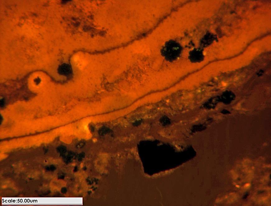
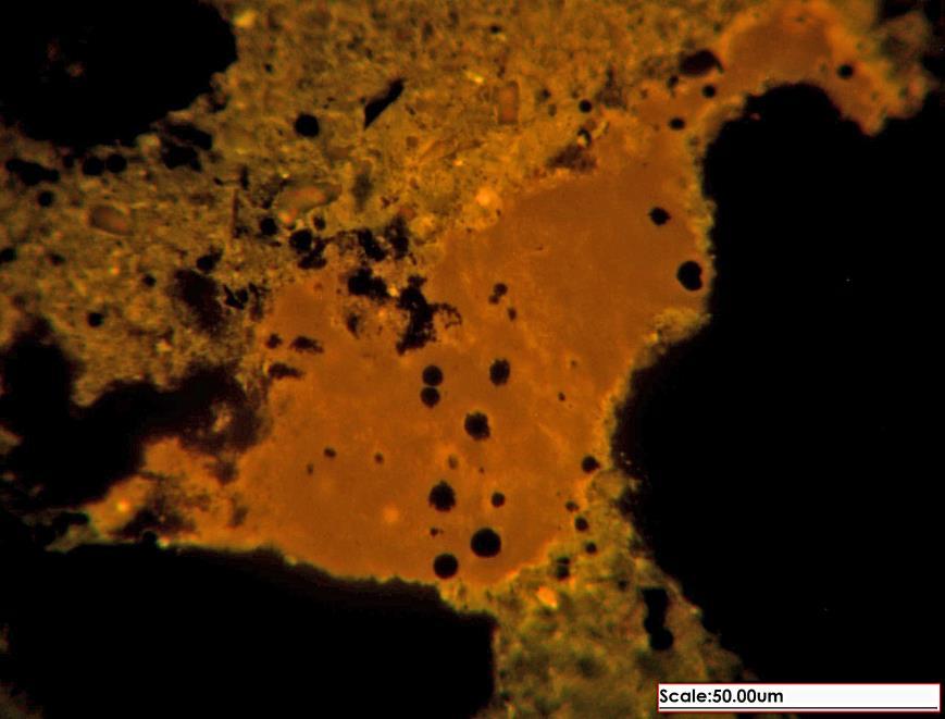
19 White Light Fluorescent (UV) Light


20 White Light Fluorescent (UV) Light


21 White Light Fluorescent (UV) Light


22 White Light Fluorescent (UV) Light

23 Eastern Interior Basin Western Kentucky Study Interval
24 Carbondale Formation Carbondale Formation coals tend to occur in vertically repetitive, coarsening-upward sequences, called cyclothems. Cyclothems, which represent parasequences, are usually 50 to 75 ft thick. Carbondale coal beds are usually overlain by black shales. These black shales commonly contain marine fossils, and have high total organic carbon (TOC) contents. (from Greb and others, 1992, KGS Bulletin 2, Fig. 34)
 Basin")
25 Eastern Interior (Illinois) Basin Warrrior Cores
26 cm 37.0 TOC Profiles Western Kentucky Roof Shales WKY # 9 Roof Shale cm WKY # 9 Roof Shale Avg. TOC 18.0 % 34.0 Avg. TOC 20.0 % cm 53.0 WKY # 11 Roof Shale cm 91.0 WKY # 11 Roof Shale Avg. TOC 20.9 % Avg. TOC 16.6 %


27 cm 37.0 Maceral Profiles -- Western Kentucky Roof Shales WKY # 9 Roof Shale cm WKY # 9 Roof Shale Averag e V 7.8 L 55.2 I Averag e V 7.2 L 62.3 I cm 53.0 WKY # 11 Roof Shale cm 91.0 WKY # 11 Roof Shale Averag e V 6.3 L 44.7 I Averag e V 5.3 L 62.5 I
28 % Ro Thermomaturation 0.70 Calculated Ro from Tmax (Tmax * 0.018) Calculated Ro maximum (Ro random * 1.07) Measured Ro random (avg. 50/sample) Tmax Calculated Measured Calculated 0 C Ro Ro random Ro maximum Average Maximum Minimum
29 % Ro 0.70 Thermomaturation Rock Eval Comparison Laboratory A Laboratory B Tmax Ro Tmax Ro KGS KGS KGS KGS KGS Average
30 Colchester CBM Core P-42, Hopkins Co., Kentucky Shale 1.2 ft Coal 1.0 ft Davis Shale 0.3 ft Vitrinite (mmf) Liptinite (mmf) Inertinite (mmf) Coal 2.7 ft %
31 CBM Core P-42, Hopkins Co., Kentucky Roof Shale 1.7 ft % WKY #11 Coal 6.4 ft Vitrinite (mmf) Liptinite (mmf) Inertinite (mmf) Roof Shale 1.9 ft WKY #9 Coal 4.7 ft
32 CBM Core P-42, Hopkins Co., Kentucky Shale 1.2 ft Coal 1.0 ft Colchester Gas Content (scf/ton, as received basis) Shale 0.3 ft Coal 2.7 ft Davis
33 CBM Core P-42, Hopkins Co., Kentucky Roof Shale 1.7 ft WKY #11 Coal 6.4 ft Gas Content (scf/ton, as received basis) Roof Shale 1.9 ft WKY #9 Coal 4.7 ft
34 Roof Shale CBM Core P-42, Hopkins Co., Kentucky WKY #11 WKY #9 WKY #8b-1 WKY #8b-2 Colchester WKY # Vitrinite (mmf) Liptinite (mmf) Inertinite (mmf) WKY #11 WKY #9 WKY #8b-1 WKY #8b-2 Colchester WKY #6 Avg. TOC 25.5 % Avg. Sulfur Content 4.4 %
35 WKY #6 Colchester WKY #8b-2 WKY #8b-1 WKY #9 WKY #11 % Ro Thermomaturation Calculated Ro maximum (Ro random * 1.07) Measured Ro random (avg. 50/sample) Measured Ro bituminite (avg. 50/sample)

 0 10")
36 Telovitrinite Bituminite Bituminite WKY #11 WKY #9 WKY #8b-1 WKY #8b-2 Colchester WKY #6 Gas Content (scf/ton)
37 % Ro 0.70 Thermomaturation Calculated Ro maximum (Ro random * 1.07) Measured Ro random (avg. 50/sample) Measured Ro bituminite (avg. 50/sample) WKY #11 WKY #9 Colchester WKY #6 Tmax Ro Ro Ro calc. rand. bit. WKY # WKY # Colchester WKY #


38 White Light Fluorescent (UV) Light


39 White Light Fluorescent (UV) Light


40 White Light Fluorescent (UV) Light


41 White Light Fluorescent (UV) Light
 Moderate (25 50 %) Common Macerals Fusinite, SF, Secretinite Micrinite Major OM Source Tereestrial Marine Thermomaturation")
42 Summary Central Appalachian Basin Eastern Interior Basin Total Organic Carbon Low (<5 %) High (>15 %) Vitrinite Low (15 to 40 %) Very Low (<25 %) Liptinite Moderate (25 50 %) High (>50 %) Common Macerals Sporinite Bituminite, Bitumen, AOM Inertinite Moderate (25 50 %) Moderate (25 50 %) Common Macerals Fusinite, SF, Secretinite Micrinite Major OM Source Tereestrial Marine Thermomaturation Level Low to High Low to Moderate Reflectance (% Ro) 0.6 to > to 0.8 Tmax ( 0 C) 430 to > to 440
43 Summary Illinois Basin Central Appalachian Basin Marine sources and flooding from west and south Gray shales Black shales Coal Middle Penn Clastic influx from east Coal Lower-Middle Penn Lower subsidence More clays Higher TOCs Higher subsidence More silt Lower TOCs

44 Thank You
Update on the Berea Sandstone Oil Play in Kentucky
 Update on the Berea Sandstone Oil Play in Kentucky Stephen F. Greb, David C. Harris, Thomas M. (Marty) Parris, Cortland F. Eble, and Brandon C. Nuttall Kentucky Geological Survey, University of Kentucky
EUSTATIC AND TECTONIC CONTROL OF SEDIMENTATION IN THE PENNSYLVANIAN STRATA OF THE CENTRAL APPALACHIAN BASIN, USA
 Comptes Rendus XII ICC-P Volume 2:421-430 Buenos Aires, 1993 EUSTATIC AND TECTONIC CONTROL OF SEDIMENTATION IN THE PENNSYLVANIAN STRATA OF THE CENTRAL APPALACHIAN BASIN, USA Donald R. CHESNUT Jr. Kentucky
Evaluation of geological characteristics of the New Albany Shale as a potential liquids-from- shale play in the Illinois Basin
 2014 Eastern Unconventional Oil and Gas Symposium - November 5-7, 2014 in Lexington, Kentucky, USA http://www.euogs.org Evaluation of geological characteristics of the New Albany Shale as a potential liquids-fromshale
University of Cincinnati P.O. Box 3092 Cincinnati, OH Houston, TX Department of Geological Sciences
 63 Tectono-Climatic Controls on Broad-Scale Patterns of Compositional Variation in the Upper Devonian Cleveland Member of the Ohio Shale, Central Appalachian Basin Jacek Jaminski 1,*, Thomas J. Algeo 1,
Western Kentucky Coalbed Methane Consortium
 Western Kentucky Coalbed Methane Consortium A Proposed Joint Geologic Study of the Coal-Bearing Strata of the Western Kentucky Coal Field Emphasizing Coalbed Methane Resource Characterization Kentucky
Shallow marine facies. Outline 13: The Paleozoic World. Shallow marine and terrestrial facies
 Outline 13: The Paleozoic World Shallow marine and terrestrial facies Shallow marine facies Sea level was much higher than today during much of the Paleozoic. Shallow epicontinental seas flooded continental
South Texas* Paul C. Hackley 1, Kristin Dennen 1, Rachel Gesserman 1, and Jennie L. Ridgley 2
 AV Preliminary Investigation of the Thermal Maturity of Pearsall Formation Shales in the Maverick Basin, South Texas* Paul C. Hackley 1, Kristin Dennen 1, Rachel Gesserman 1, and Jennie L. Ridgley 2 Search
Michael G. McClure. Current Position. Profession. Significant Projects. Years' Experience. Education. Specific Projects. Professional Registrations
 Michael G. McClure Current Position Principal Geologist Profession Geology Years' Experience 39+ Education MS - Geology, University of Kentucky, Lexington, KY BS - Geology, Brigham Young University, Provo,
CARTER METALLURGICAL COAL PROJECT. Endurance Gold Corporation (EDG)
") CARTER METALLURGICAL COAL PROJECT McDOWELL COUNTY, WEST VIRGINIA Endurance Gold Corporation (EDG) Endurance Resources Inc. (ERI) Prepared by: Duncan McIvor, President and CEO Endurance Gold Corporation
CARTER METALLURGICAL COAL PROJECT McDOWELL COUNTY, WEST VIRGINIA Endurance Gold Corporation (EDG) Endurance Resources Inc. (ERI) Prepared by: Duncan McIvor, President and CEO Endurance Gold Corporation
OVERVIEW OF THE ROGERSVILLE SHALE IN WEST VIRGINIA. Philip Dinterman West Virginia Geological & Economic Survey May 11, 2017
 OVERVIEW OF THE ROGERSVILLE SHALE IN WEST VIRGINIA Philip Dinterman West Virginia Geological & Economic Survey May 11, 2017 ACKNOWLEDGEMENT Dave Harris, John Hickman, Kentucky Geological Survey DATA NOTE
The Coal Geologist. Greetings from the Chair. Newsletter of the Coal Geology Division of the Geological Society of America
 The Coal Geologist Winter 2010 Volume 36, Number 2 Newsletter of the Coal Geology Division of the Geological Society of America Greetings from the Chair It was great to see so many of you at the GSA Annual
ERC ANALYTICAL REPORT EXAMPLE PETROGRAPHY REPORT PETROGRAPHIC ANALYSIS LAST CHANCE #3A PREPARED FOR GASSY COAL COMPANY NL APRIL 2050
 ANALYTICAL REPORT PETROGRAPHIC ANALYSIS LAST CHANCE #3A PREPARED FOR GASSY COAL COMPANY NL APRIL 25 Energy Resources Consulting Pty Ltd PO Box 54 Coorparoo, Qld 4151 Australia PETROGRAPHIC ANALYSIS INTRODUCTION
Relationships of the Ordovician. Appalachian Basin. June 21, 2011
 Regional Stratigraphic and Facies Relationships of the Ordovician Utica/Point i t Pleasant Interval in the Appalachian Basin June 21, 2011 Ron Riley and Mark Baranoski Stratigraphic Correlation Chart Modified
secarb.org Southeast Regional Carbon Sequestration Partnership (SECARB) Central Appalachian Coal Seam Project
 Central Appalachian Coal Seam Project") Southeast Regional Carbon Sequestration Partnership (SECARB) secarb.org Field Test Location Russell County, Virginia Amount and Sources of CO 2 1,000 Tons from Commercial Source Primary Contacts DOE/NETL
Southeast Regional Carbon Sequestration Partnership (SECARB) secarb.org Field Test Location Russell County, Virginia Amount and Sources of CO 2 1,000 Tons from Commercial Source Primary Contacts DOE/NETL
secarbon.org Southeast Regional Carbon Sequestration Partnership (SECARB) Central Appalachian Coal Seam Project
 Central Appalachian Coal Seam Project") Southeast Regional Carbon Sequestration Partnership (SECARB) secarbon.org Field Test Location Russell County, Virginia Amount and Sources of CO 2 1,000 Tons from Commercial Source Primary Contacts DOE/NETL
Southeast Regional Carbon Sequestration Partnership (SECARB) secarbon.org Field Test Location Russell County, Virginia Amount and Sources of CO 2 1,000 Tons from Commercial Source Primary Contacts DOE/NETL
STRUCTURAL CONTROLS ON ENVIRONMENTS OF DEPOSITION, COAL QUALITY, AND RESOURCES IN THE APPALACHIAN BASIN IN KENTUCKY
 STRUCTURAL CONTROLS ON ENVIRONMENTS OF DEPOSITION, COAL QUALITY, AND RESOURCES IN THE APPALACHIAN BASIN IN KENTUCKY DONALD C. HANEY JAMES C. COBB DONALD R. CHESNUT JAMES C. CURRENS Kentucky Geological
GEOLOGIC FINDINGS OF THE BENEDUM FOUNDATION S APPALACHIAN STORAGE HUB STUDY
 1 GEOLOGIC FINDINGS OF THE BENEDUM FOUNDATION S APPALACHIAN STORAGE HUB STUDY Kristin M. Carter, P.G., C.P.G. Assistant State Geologist Pennsylvania Geological Survey (Pittsburgh, PA) krcarter@pa.gov ACKNOWLEDGEMENTS
SEQUENCE STRATIGRAPHIC ARCHITECTURE OF EARLY PENNSYLVANIAN, COAL-BEARING STRATA OF THE CUMBERLAND BLOCK: A CASE STUDY FROM DICKENSON COUNTY, VIRGINIA
 SEQUENCE STRATIGRAPHIC ARCHITECTURE OF EARLY PENNSYLVANIAN, COAL-BEARING STRATA OF THE CUMBERLAND BLOCK: A CASE STUDY FROM DICKENSON COUNTY, VIRGINIA Robert J. Bodek Jr. Thesis submitted to the Faculty
FY 2013 Annual Technical Report for NCRDS State Cooperative Program
 FY 2013 Annual Technical Report for NCRDS State Cooperative Program SUBSURFACE GAS-SHALE SAMPLES OF THE UPPER DEVONIAN AND LOWER MISSISSIPPIAN WOODFORD SHALE, PERMIAN BASIN, WEST TEXAS AND SOUTHEASTERN
High-resolution Sequence Stratigraphy of the Glauconitic Sandstone, Upper Mannville C Pool, Cessford Field: a Record of Evolving Accommodation
 Page No. 069-1 High-resolution Sequence Stratigraphy of the Glauconitic Sandstone, Upper Mannville C Pool, Cessford Field: a Record of Evolving Accommodation Thérèse Lynch* and John Hopkins, Department
Reservoir Characterization for the Application of ASP Flood Technology in the Bridgeport Sandstone in Lawrence Field, Illinois*
 Reservoir Characterization for the Application of ASP Flood Technology in the Bridgeport Sandstone in Lawrence Field, Illinois* Nathan D. Webb 1, Vineeth Madhavan 1, John P. Grube 1, Curt S. Blakley 1,
URBANA. 'Ll-'NOIS STATE GE0L0G CAL SURVEY
 URBANA 'Ll-'NOIS STATE GE0L0G CAL SURVEY 3 3051 00003 5240 Digitized by the Internet Archive in 2012 with funding from University of Illinois Urbana-Champaign http://archive.org/details/rhythmsinupperpe92well
Chapter Three: Coalbed Gas in the Cherokee Basin
 Chapter Three: Coalbed Gas in the Cherokee Basin The first test in Kansas to assess coalbed gas potential in southeastern Kansas was from several wells drilled during the late 1980 s in Wilson and Montgomery
A surficial. P^HiHI waste disposal site, Bureau County, Illinois. east of the Sheffield low-level radioactive. electrical resistivity survey
 ISGS CONTRACT/GRANT REPORT 1981-6 WATER RESOURCES DIVISION/USGS P^HiHI 100240 557.09773 IL6cr 1981-6 A surficial electrical resistivity survey east of the Sheffield low-level radioactive waste disposal
Petrography of Ardley Coals, Alberta Implications for Coalbed Methane Potential
 5 EUB/AGS Special Report 55 Petrography of Ardley Coals, Alberta Implications for Coalbed Methane Potential W. Kalkreuth 1 and C.W. Langenberg 1 Universidade Federal do Rio Grande do Sul (Brazil) December
AN APPLICATION OF ACID BASE ACCOUNTING FOR HIGHWAY CONSTRUCTION IN EAST TENNESSEE 1
 AN APPLICATION OF ACID BASE ACCOUNTING FOR HIGHWAY CONSTRUCTION IN EAST TENNESSEE 1 by J.T. Ammons C.B. Coburn, Jr. P.A. Shelton 2 Abstract. Concern over the environmental impact of highway construction
Nathan D. Webb and James L. Best
 Nathan D. Webb and James L. Best Background Pennsylvanian oil production Stratigraphy & geologic setting Study area Methods Using geophysical logs & core Results Comparing three channel deposits Implications
MIDWEST REGIONAL CARBON SEQUESTRATION PARTNERSHIP PHASE II STORAGE CAPACITY POTENTIAL OVERVIEW
 FINAL MIDWEST REGIONAL CARBON SEQUESTRATION PARTNERSHIP PHASE II STORAGE CAPACITY POTENTIAL OVERVIEW SUMMARY OF PHASE II TOPICAL REPORTS DOE-NETL Cooperative Agreement DE-FC26-05NT42589 Submitted by: Battelle
CO 2 adsorption in coals as a function of rank and composition: A task in USGS research on geologic sequestration of CO 2
 CO 2 adsorption in coals as a function of rank and composition: A task in USGS research on geologic sequestration of CO 2 Robert C. Burruss USGS, Reston, VA Project Tasks 1. Adsorption Properties of Coals
Atlantic Rim Coalbed Methane Play: The Newest SuccessfulCBM Play in the Rockies
 Atlantic Rim Coalbed Methane Play: The Newest SuccessfulCBM Play in the Rockies Robert A. Lamarre Lamarre Geological, Denver, Colorado Stephen K. Ruhl Anadarko Petroleum Corporation, The Woodlands, Texas
Bedrock Geology of Dekoven Quadrangle
 STATEMAP Dekoven-BG Bedrock Geology of Dekoven Quadrangle Hardin County, Illinois, and Union and Crittenden Counties, Kentucky Mary J. Seid, F. Brett Denny, and W. John Nelson 2013 Prairie Research Institute
OIL SHALE OCCURRENCES IN UPPER ASSAM BASIN, INDIA : AN OVERVIEW
 OIL SHALE OCCURRENCES IN UPPER ASSAM BASIN, INDIA : AN OVERVIEW V.K.Sibal Srinivasan V.Raju Directorate General of Hydrocarbons New Delhi SEDIMENTARY BASIN MAP OF INDIA 2 HYDROCARBON RESOURCE BASE Sedimentary
Leslie F. Ruppert U.S. Geological Survey, National Center
 Energeia Home Vol. 13, No. 2, 2002 U.S. Geological Survey s National Coal Resource Assessment: Coal Resources of the Northern and Central Appalachian Basin Coal Regions Leslie F. Ruppert U.S. Geological
FUNDAMENTALS OF SEQUESTRATION IN COAL & SHALE
 FUNDAMENTALS OF SEQUESTRATION IN COAL & SHALE Dr. Jack Pashin Geological Survey of Alabama CAS/SME Fall 2010 Short Course 10/15/2010 Lexington, KY MAJOR TOPICS What are coal and shale? Fundamental reservoir
MAPPING AND RESERVOIR CHARACTERIZATION OF GEOLOGIC INTERVALS FOR NGL STORAGE APPLICATIONS
 MAPPING AND RESERVOIR CHARACTERIZATION OF GEOLOGIC INTERVALS FOR NGL STORAGE APPLICATIONS Robin V. Anthony 1, Doug Patchen 2, Jessica Moore 3, Michael Solis 4 1 PA DCNR, Bureau of Topographic & Geologic
Compositional Variations
 Kentucky Geological Survey Donald C. Haney, State Geologist and Director University of Kentucky, Lexington Compositional Variations in the Fire Clay Coal Bed of Eastern Kentucky: Geochemistry, Petrography,
New Albany Shale? Brandon C. Nuttall, Speaker Kentucky Geological Survey KOGA, Louisville, Ky 16 Jul 2014
 Oil and NGLs in the Devonian New Albany Shale? Brandon C. Nuttall, Speaker Kentucky Geological Survey KOGA, Louisville, Ky 16 Jul 2014 Natural Gas Phases at 1 Atm Benzene (C6) Hexane (C6) Pentane (C5)
0708 Carbon Sequestration and Enhanced Coalbed Methane Recovery Potential of the Cahaba and Coosa Coalfields in the Southern Appalachian Thrust Belt
 0708 Carbon Sequestration and Enhanced Coalbed Methane Recovery Potential of the Cahaba and Coosa Coalfields in the Southern Appalachian Thrust Belt M. R. McIntyre and J. C. Pashin Geological Survey of
Sequence Stratigraphy of the Upper Cretaceous Niobrara Formation, A Bench, Wattenberg Field, Denver Julesburg Basin, Colorado*
 Sequence Stratigraphy of the Upper Cretaceous Niobrara Formation, A Bench, Wattenberg Field, Denver Julesburg Basin, Colorado* Lisa E. Remington LaChance 1 and Mark C. Robinson 1 Search and Discovery Article
Western Kentucky CO 2 Storage Test
 Western Kentucky CO 2 Storage Test Principal Investigators: Rick Bowersox - Lexington Dave Williams - Henderson KGS First Friday Seminar Lexington, Kentucky March 4, 2011 The project proceeded in two phases:
PERMO-CARBONIFEROUS CONDITIONS VERSUS PERMO-CARBONIFEROUS TIME
 PERMO-CARBONIFEROUS CONDITIONS VERSUS PERMO-CARBONIFEROUS TIME University of Michigan Although "red beds" of late Paleozoic and or deposits of equivalent age have long been called Permian in North America,
Regional Trends in Coalbed Gas Composition and Thermal Maturation in Eastern Kansas: Implications for Predicting Quality and Location of Coalbed Gas
 Regional Trends in Coalbed Gas Composition and Thermal Maturation in Eastern Kansas: Implications for Predicting Quality and Location of Coalbed Gas K. David Newell and L. Michael Magnuson Kansas Geological
Cretaceous, Dakota Formation, Terra Cotta Member South Side of I-70, Salina County, Kansas
 Cretaceous, Dakota Formation, Terra Cotta Member South Side of I-70, Salina County, Kansas Written By: Steven D.J. Baumann G-102010-1A Outcrop looking southeast Photo taken by: Steven Baumann on 10-20-2010
Dr. Kenneth B. Taylor, P.G.
 North Carolina Forestry Association 2013 Annual Meeting October 3, 2013 Shale Gas 101: Natural Gas Exploration / Development: A North Carolina Perspective presented by Dr. Kenneth B. Taylor, P.G. State
Donald R. Chesnut, Jr. and James C. Cobb. (Kentucky Geological Survey, Lexington, Kentucky, USA) Robert A. Gastaldo
 Robert A. Gastaldo") XI Congres International de Stratigraphie et de Geologie du Carbonifere Beijing 1987, Compte Rendu 2 (1989): 20-30 ORIGIN OF THE MIDDLESBORO MEMBER OF THE LOWER PENNSYLVANIAN-AGE LEE FORMATION (BASHKIRIAN)
XI Congres International de Stratigraphie et de Geologie du Carbonifere Beijing 1987, Compte Rendu 2 (1989): 20-30 ORIGIN OF THE MIDDLESBORO MEMBER OF THE LOWER PENNSYLVANIAN-AGE LEE FORMATION (BASHKIRIAN)
Where to Drill in Western Kentucky February
 Where to Drill in Western Kentucky? February 7. 2008 J.A. Drahovzal 2/7/08 Assumptions to Date and Questions Drill no more than 8,000 feet Drill multi-horizons (at least 2 major horizons) Do we want to
Lecture 4: The sedimentary history of the Western Irish Carboniferous basin nomenclature, paleontology and zoning. Sources of sediment and basin
 Lecture 4: The sedimentary history of the Western Irish Carboniferous basin nomenclature, paleontology and zoning. Sources of sediment and basin paleogeographic reconstructions. Models for basin fill.
Integrating Geomechanics and Reservoir Characterization Examples from Canadian Shale Plays
 Integrating Geomechanics and Reservoir Characterization Examples from Canadian Shale Plays AAPG Geosciences Technology Workshops Geomechanics and Reservoir Characterization of Shale and Carbonates July
Lower Skinner Valley Fill Sandstones: Attractive Exploration Targets on the Northeast Oklahoma Platform*
 Lower Skinner Valley Fill Sandstones: Attractive Exploration Targets on the Northeast Oklahoma Platform* By Jim Puckette 1 Search and Discovery Article #10050 (2003) *Adapted from presentation to Tulsa
PHYSIOGRAPHIC REGIONS OF THE LOWER 48 UNITED STATES
 PHYSIOGRAPHIC REGIONS OF THE LOWER 48 UNITED STATES LAURENTIAN UPLAND 1. Superior Upland ATLANTIC PLAIN 2. Continental Shelf (not on map) 3. Coastal Plain a. Embayed section b. Sea Island section c. Floridian
Evaluation of Neocomian Shale source rock In Komombo Basin, Upper Egypt
 Evaluation of Neocomian Shale source rock In Komombo Basin, Upper Egypt Abdelhady, A. 1, Darwish, M. 2, El Araby, A. 3 and Hassouba, A. 4 1 DEA Egypt, Cairo, Egypt 2 Geology Department, Faculty of Science,
22. PETROLEUM-GENERATING POTENTIAL OF SEDIMENTS FROM LEG 44, DEEP SEA DRILLING PROJECT
 . PETROLEUM-GENERATING POTENTIAL OF SEDIMENTS FROM LEG, DEEP SEA DRILLING PROJECT J.W. Kendrick, A. Hood, and J.R. Castano, Shell Development Company, Houston, Texas ABSTRACT The abundance, type, and thermal
CASE STUDY #9 - Brushy Fork Dam, Sugar Grove, West Virginia
 CASE STUDY #9 - Brushy Fork Dam, Sugar Grove, West Virginia Brushy Fork Dam is a flood control structure built by the Soil Conservation Service southeast of the city of Franklin in Pendleton County, West
Mining Methods. Power Plants
 Coal: A comparison of depositional settings and chemical compositions in the Monongahela Group and Kanawha Formation Lisa Horvath PhD Preliminary Exam 2/15/07 Department of Geology and Geography Advisor:
General Geologic Setting and Seismicity of the FHWA Project Site in the New Madrid Seismic Zone
 General Geologic Setting and Seismicity of the FHWA Project Site in the New Madrid Seismic Zone David Hoffman University of Missouri Rolla Natural Hazards Mitigation Institute Civil, Architectural & Environmental
Bulletin of Earth Sciences of Thailand
 Quantitative Seismic Geomorphology of Early Miocene to Pleistocene Fluvial System of Northern Songkhla Basin, Gulf of Thailand Oanh Thi Tran Petroleum Geoscience Program, Department of Geology, Faculty
Petroleum System Modelling applied to the evaluation of HC in Place in Unconventional Gas Shale prospects
 Petroleum System Modelling applied to the evaluation of HC in Place in Unconventional Gas Shale prospects Domenico Grigo 28 April, 2011 www.eni.it applied to Gas Shale Prospect characterisation Why? In
An Evaluation of Pavement Drainage Interstate 64, Rowan-Carter Counties
 Transportation Kentucky Transportation Center Research Report University of Kentucky Year 1984 An Evaluation of Pavement Drainage Interstate 64, Rowan-Carter Counties David L. Allen Herbert F. Southgate
Sedimentary and Stratigraphic Analysis of the Viking Sand in the Edgerton/Wainwright Area, Central Alberta* By Russell Walz 1
 Sedimentary and Stratigraphic Analysis of the Viking Sand in the Edgerton/Wainwright Area, Central Alberta* By Russell Walz 1 Search and Discovery Article #50030 (2006) Posted June 25, 2006 *Extended abstract
Platt s 22 nd Annual Coal Properties And Investment
 Platt s 22 nd Annual Coal Properties And Investment Demand and Production of Thermal and Met Coal Palm Beach Gardens, Florida March 17 18, 2014 Alan K. Stagg Stagg Resource Consultants, Inc. U.S Metallurgical
The Geologic Context of Landslide and Rockfall Maintenance Costs in Kentucky
 Kentucky Geological Survey University of Kentucky, Lexington The Geologic Context of Landslide and Rockfall Maintenance Costs in Kentucky Bethany L. Overfield, Daniel I. Carey, Gerald A. Weisenfluh, Rebecca
A Petrophysical Model to Quantify Pyrite Volumes and to Adjust Resistivity Response to Account for Pyrite Conductivity
 A Petrophysical Model to Quantify Pyrite Volumes and to Adjust Resistivity Response to Account for Pyrite Conductivity Presented at the 2013 AAPG ACE, Pittsburgh PA May 19-22 By Michael Holmes, Antony
P.R. SPRING AND HILL CREEK TAR SAND AREAS A RESOURCE ASSESSMENT (IN PROGRESS)
") P.R. SPRING AND HILL CREEK TAR SAND AREAS A RESOURCE ASSESSMENT (IN PROGRESS) presented by WALLY GWYNN - Utah Geological Survey at the Western U.S. Oil Sands Technology Transfer Meeting February 22, 2008
P.R. SPRING AND HILL CREEK TAR SAND AREAS A RESOURCE ASSESSMENT (IN PROGRESS) presented by WALLY GWYNN - Utah Geological Survey at the Western U.S. Oil Sands Technology Transfer Meeting February 22, 2008
Geotechnical Aspects of the Ohio River Bridges Project
 Geotechnical Aspects of the Ohio River Bridges Project Mark A. Litkenhus, PE Sr. Geotechnical Engineer Stephen H. Bickel, PE Sr. Geotechnical Engineer STGEC Ohio River Bridges at Louisville Geotechnical
Search and Discovery Article #80341 (2013)** Posted November 25, 2013
** Posted November 25, 2013") Niobrara Source Rock Maturity in the Denver Basin: A Study of Differential Heating and Tectonics on Petroleum Prospectivity Using Programmed Pyrolysis* David J. Thul 1,2 and Steve Sonnenberg 2 Search and
Niobrara Source Rock Maturity in the Denver Basin: A Study of Differential Heating and Tectonics on Petroleum Prospectivity Using Programmed Pyrolysis* David J. Thul 1,2 and Steve Sonnenberg 2 Search and
GEOGRAPHY OF THE UNITED STATES & CANADA. By Brett Lucas
 GEOGRAPHY OF THE UNITED STATES & CANADA By Brett Lucas THE APPALACHIANS & THE OZARKS Setting the Boundaries What states and provinces are part of the region? Eastern TN, western NC, eastern KY, western
Key Elements of the Petroleum Systems of the Rockall and Slyne-Erris Basins
 Key Elements of the Petroleum Systems of the Rockall and Slyne-Erris Basins Bandon Corrib Dooish Atlantic Ireland Conference, Dublin, 1 st - 2 nd November 2016 Rockall and Slyne-Erris Basins Only 11 exploration
Triassic of the Barents Sea shelf: depositional environments and hydrocarbon potential. Daria A. Norina 1,2
 Triassic of the Barents Sea shelf: depositional environments and hydrocarbon potential Daria A. Norina 1,2 1 TOTAL (Paris, France) 2 The work is a part of PhD thesis conducted in Petroleum Department,
University of Kentucky Master's Theses
 University of Kentucky UKnowledge University of Kentucky Master's Theses Graduate School 2003 CLASSIFICATION OF PALEOCHANNELS AND THEIR RELATIONSHIP TO SYNSEDIMENTARY FAULTING WITHIN THE LOWER ELKHON COAL
Core Description, Stratigraphic Correlation, and Mapping of Pennsylvanian Strata in the Appalachians
 Core Description, Stratigraphic Correlation, and Mapping of Pennsylvanian Strata in the Appalachians The remaining laboratory sessions for the semester will be collected into a series of exercises designed
Geochemical Appraisal using Vitrinite Reflectance and Rock-Eval Data, of Shishtu and Sardar Formations Central Iran
 Geochemical Appraisal using Vitrinite Reflectance and Rock-Eval Data, of Shishtu and Sardar Formations Central Iran Jahangard. A. A, Alizadeh. B, Hosseini. S. H. Department of Geology, Faculty of Earth
Algeo et al. Changes in ocean denitrification during Late Carboniferous glacial-interglacial cycles NGS
 Algeo et al. Changes in ocean denitrification during Late Carboniferous glacial-interglacial cycles NGS-27-11-379 Supplementary Methods Crossplots of total organic carbon (TOC) versus total nitrogen (TN)
FY 2008 Annual Technical Report for NCRDS State Cooperative Program
 FY 2008 Annual Technical Report for NCRDS State Cooperative Program SUBSURFACE JURASSIC AND CRETACEOUS GAS-SHALE SAMPLES, HAYNESVILLE AND BOSSIER FORMATIONS (SABINE UPLIFT), AND EAGLEFORD GROUP (RIO GRANDE
Basin and Petroleum System Modeling for Piceance Basin and Uncertainty Quan8fica8on
 Basin and Petroleum System Modeling for Piceance Basin and Uncertainty Quan8fica8on Yao Tong 1, Tapan Mukerji 1, Allegra Hosford Scheirer 1, Paul Weimer 2, Stephen Cumella 3, Kenneth Peters 4 1. Stanford
For personal use only
 31 January 2014 Quarterly Report for the period ending 31 December 2013 Premier transaction completed with improved terms Due diligence drilling completed and exploration continues in 2014 Significant
DRILLING REPORT (DGO-GO-14)
") Commonwealth of Virginia Department of Mines, Minerals, and Energy Division of Gas and Oil P.O. Box 1416; Abingdon, VA 24212 Telephone: (276) 676-5423 Tracking Number: Company: File Number: Operations
Commonwealth of Virginia Department of Mines, Minerals, and Energy Division of Gas and Oil P.O. Box 1416; Abingdon, VA 24212 Telephone: (276) 676-5423 Tracking Number: Company: File Number: Operations
APPALACHIAN COLLUVIAL
 LANDSLIDE PROBLEMS ON APPALACHIAN COLLUVIAL SLOPES Geohazards in Transportation in the Appalachian Region Charleston, WV August 5 7, 2008 RICHARD E. GRAY DIGIOIA, GRAY & ASSOCIATES, LLC. 570 BEATTY ROAD
The Paleozoic Hudson Bay Basin in Northern Canada: New Insights Into Hydrocarbon Potential of the Last North-America Conventional Frontier Basin*
 The Paleozoic Hudson Bay Basin in Northern Canada: New Insights Into Hydrocarbon Potential of the Last North-America Conventional Frontier Basin* Denis Lavoie 1, Nicolas Pinet 1, Jim Dietrich 2 and Zhuoheng
Dakota Sandstone. of the Moxa Arch and Surrounding Green River Basin
 Dakota Sandstone of the Moxa Arch and Surrounding Green River Basin Dakota Sandstones of the Green River Basin Overview The Dakota sandstones of the Moxa Arch and surrounding Green River Basin remain attractive
RELINQUISHMENT REPORT. License P1546 Block April 2009
 RELINQUISHMENT REPORT License P1546 Block 110-01 14 April 2009 Sherritt International Oil and Gas Limited 2000, 425-1 st street S.W., Calgary, Alberta Canada T2P 3L8 Telephone (403) 260-2900 Fax (403)
Sedimentary cycles in coal and evaporite basins and the reconstruction of Palaeozoic climate
 Sedimentary cycles in coal and evaporite basins and the reconstruction of Palaeozoic climate F.J.G. van den Belt Utrecht Studies in Earth Sciences Mededelingen van de Faculteit Geowetenschappen Universiteit
GEOLOGY, RESOURCES, AND POTENTIAL ACTIVITY LEVELS
 GEOLOGY, RESOURCES, AND POTENTIAL ACTIVITY LEVELS NAS Workshop on the Development of Unconventional Hydrocarbon Resources in the Appalachian Basin Ray Boswell, US DOE/NETL Morgantown, West Virginia September
Canol Formation Oil Shale, Exhumation Charge, and Regional Geology of the Central Mackenzie, NWT
 Photo: Canol Fm near Arctic Red River Canol Formation Oil Shale, Exhumation Charge, and Regional Geology of the Central Mackenzie, NWT Hadlari T. Geological Survey of GSC 2018 Introduction Research made
Stromatoporoids around the Georgetown, Kentucky area
 Stromatoporoids around the Georgetown, Kentucky area If you have ever visited and / or travelled around the area of Georgetown, Scott County, Kentucky you might have noted white watermelon shaped rocks
Petroleum Potential of the Application Area L12-4
 Petroleum Potential of the Application Area L12-4 The Application Area (L12-4) is underlain by the western Officer Basin, beneath the Gunbarrel Basin. The general basin architecture is outlined in Figure
Identification of Future Oil Potential From Upper Devonian Venango Sandstones in the Central Appalachians
 Identification of Future Oil Potential From Upper Devonian Venango Sandstones in the Central Appalachians Eric Ober, Craig Eckert January 23, 2014 Overview History of Oil Drilling In West Virginia Geology
North Dakota Geological Survey
 Review of Hydrocarbon Production from the Stonewall and lower Interlake Formations: western North Dakota Williston Basin Timothy O. Nesheim North Dakota Geological Survey North Dakota Geological Survey
2012 USACE Drought Actions
 2012 USACE Drought Actions for Inland Waterway Users Board 68 Jim Walker Navigation Branch Chief 19 December 2012 US US Army Corps of of Engineers US Drought Monitor 1 2 3 4 6 5 Impacts: 1. The area in
Stephanie J. Connolly Forest Soil Scientist
 Stephanie J. Connolly Forest Soil Scientist Approximately 1 million acres High elevation Steep slopes Rain shadow effect Hydrologically shallow soils Sedimentary geology Acidic environments Biodiversity
Elevation s Barnett Oil Play: Its Genesis and Why it Works. April 25, 2018
 Elevation s Barnett Oil Play: Its Genesis and Why it Works April 25, 2018 UL Permian Basin Position Posted: 2018 Horizontal Spuds (IHS Energy) UL 2018 Partners Forum - April 25, 2018 2 April 2013 (Elevation
Structural Style in the Peel Region, NWT and Yukon
 Structural Style in the Peel Region, NWT and Yukon Adriana Taborda* Husky Energy and University of Calgary, Calgary, AB Adriana.Taborda@huskyenergy.ca and Deborah Spratt University of Calgary, Calgary,
Geology of the Fire Clay Coal in Part of the Eastern Kentucky Coal Field
 Kentucky Geological Survey James C. Cobb, State Geologist and Director University of Kentucky, Lexington Geology of the Fire Clay Coal in Part of the Eastern Kentucky Coal Field Stephen F. Greb, John K.
Formation Evaluation of Unconventional Basaltic Deccan Trap Basement Reservoir of Gamij Field, Cambay Basin, India
 Formation Evaluation of Unconventional Basaltic Deccan Trap Basement Reservoir of Gamij Field, Cambay Basin, India Summary Ashok Kumar ONGC, Nazira, Assam The Deecan Trap basaltic rocks form the technical
Jordan. Target Exploration. Target Exploration
 Page1 barr Target Exploration Target Exploration barr Target Exploration Target Exploration Petroleum Potential of Wadi Sirhan Basin Jordan Petroleum Potential of Wadi Sirhan Basin, Jordan Sequence Stratigraphy,
2. What type of rocks would you expect in this area, based on the topography? What is your reasoning?
 Geology 101 Bonus Lab Name Topographic maps are useful in helping us interpret the history of the landscape of an area. The questions below are designed to help you learn to interpret topographic maps.
Detailed Sedimentology and Inorganic Geochemistry of the Dolgeville Formation and Utica Group of the Central Mohawk Valley, NY
 Detailed Sedimentology and Inorganic Geochemistry of the Dolgeville Formation and Utica Group of the Central Mohawk Valley, NY Daniel Miserendino Jeffrey T. Pietras Introduction and Purpose Drill cores
PROSPECT EVALUATION OF UNCONVENTIONAL PLAYS IN RUSSIA EPUG 2014
 PROSPECT EVALUATION OF UNCONVENTIONAL PLAYS IN RUSSIA EPUG 2014 Main definitions AGENDA Shale/shale play definition - Organic matter content - Thermal maturity Potential for unconventionals development
CUADRILLA RESOURCES LTD
 CUADRILLA RESOURCES LTD UK Shale Gas Exploration Peter Turner BSc (Wales), PhD (Leicester) CUADRILLA RESOURCES LTD Cuadrilla Resources Limited ( Cuadrilla, CRL or the Company ) was formed in September
Cuyama Basin North Fork Vineyard
 Cuyama Basin North Fork Vineyard Company Background plus Data Insights to Support GSP Development for the Cuyama Basin Presented by Grapevine Capital Partners and Cleath-Harris Geologists April 26th, 2018
REPORT OF GEOLOGICAL MAPPING ON THE MICHEL COAL LICENSE #5177. LOCATION: KOOTENAY LAND DISTRICT NTS 82-G-7 4Y028 Lat f Long.
 i *. REPORT OF GEOLOGICAL MAPPING ON THE MICHEL COAL LICENSE #5177 LOCATION: KOOTENAY LAND DISTRICT NTS 82-G-7 4Y028 Lat. 114 40f Long. ESSO RESOURCES CANADA LIMITED WARD E. KILBY WORK: OCTOBER 17 - OCTOBER