GSA Data Repository Item DR Age of Displaced Submarine Glacial Geomorphology: the Last Glacier Retreat from the Fiordland Coast
|
|
|
- Samuel Flynn
- 6 years ago
- Views:
Transcription
1 Philip M. Barnes: Post-glacial (<20 ka) dextral slip rate of the offshore Alpine Fault, New Zealand. GSA Data Repository Item DR Age of Displaced Submarine Glacial Geomorphology: the Last Glacier Retreat from the Fiordland Coast The dextrally displaced lateral moraines on the shelf south of Milford Sound have not been directly dated. However, as part of this study the coeval surface of the displaced glacial outwash fans has been dated at six sites over a 120 km lateral extent along the Fiordland margin (Table DR1). Shallow-water mollusc shell fragments entrained in the deep-water gravel debris flow deposits on the relict surface of the fans were recovered in sediment core and dredge samples, and dated by radiocarbon methods. Excluding a clearly reworked sample (Tan0405#20), the age of five samples cluster within 1500 years at the 95% confidence level, with a mean age of 16.7 cal. ka. If it is assumed that the shells were entrained into the debris flows shortly after death of the animals, and that the deposits were emplaced at or immediately after the final stages of direct outwash from the tidewater glaciers grounded at fiord entrance sills, then the mean age for these deposits is a good representation for the age of glacier retreat from the coast, and essentially the abrupt abandonment of the moraines and outwash fans. Considering the similarity in alpine altitude, it is unsurprising that the age of glacier retreat appears to be approximately coeval along the 120 km lateral extent of the northern and central Fiordland coast.
2 The mean surface outwash gravel age of 16.7 cal. ka off the Fiordland coast is generally consistent with other published glaciation records from Westland and eastern Fiordland. The youngest moraines near the coast at Cascade Plateau in south Westland, some 80 km north of Milford Sound, are undated but have been inferred to be < 19 cal. ka on the basis of cosmogenic exposure dates of ka from moraine boulders on higher and older moraines (Sutherland et al., 2007). This is consistent with dated glacial lake silts from Lake McKerrow (Fig. 1A) that indicate that the former McKerrow glacier had retreated back across the Alpine Fault in that valley by 15.6 ± 0.8 cal. ka (Sutherland and Norris, 1995). In Westland three major glacier advances to at or near the maximum, that is to the coastal edge of the lowland coastal plain, culminated at about 28, 21 and 19 cal. ka (Suggate and Almond, 2005). Multiple younger recessional moraines on the coastal lowlands, however, are not well dated but have been assumed to have formed largely by about 18 ka. Minor late glacial advances occurred in high catchment areas of Westland between 13.5 and 11.0 cal. ka (Alloway et al., 2007). Speleothem records from eastern Fiordland indicate deglaciation after 19.1 cal. ka and before 16.6 cal. ka (Williams, 1996). Considering these published glaciation records from Westland and eastern Fiordland, and the possibility that the dated coeval (~16.7 cal. ka) surface deposits on the submarine outwash fans could have been emplaced after glacier retreat from the coast, and therefore after development of the primary fan and moraine geomorphology, an age range of cal. ka is adopted for the age of the glacial features displaced by the Alpine Fault west of Fiordland, with a best estimate of 17 cal. ka. This age differs slightly from the 18 +/- 1
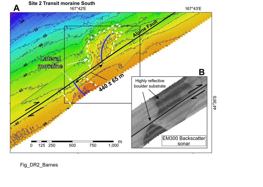
3 ka age adopted by Sutherland et al. (2006a) for glacial features near the Alpine Fault in south Westland. Dextral Displacements of Submarine Glacial Geomorphology Site 1: Transit moraine North (Lat ; Long ) The Alpine Fault displaces laterally a submerged glacial moraine ridge on the continental shelf between Milford Sound and Transit Valley (Fig. DR1; Fig.3B) (Barnes et al., 2005). The moraine ridge is about 1 km wide, 15 m high, is mantled by large glacial boulders, and is highly reflective in multibeam backscatter sonar imagery. The inner edge of the moraine is partly buried by mobile sediment near the rocky coast. The moraine is displaced by two traces of the Alpine Fault, which steps over across the ridge. The stepover width is about 500 m, and is associated with a component of normal displacement on the fault, leading to fault scarps on the moraine up to 20 m high. Onshore lateral moraine lines the northeast wall of Transit Valley, and forms a sharp moraine ridge that is about 1500 m long. It is truncated by the modern sea-cliff, but can be extrapolated over the ~1000 m to the Alpine Fault. The combination of the step over in the fault trace, partial burial of the submarine moraine by mobile sediment, and onshore to offshore projection uncertainties makes estimation of the dextral displacement difficult at this site. It is inferred that the crest of the moraine is displaced by a total of about 470 ± 120 m across both fault traces (Fig. DR1; Table DR2). Site 2: Transit moraine South (Lat ; Long ) A submerged glacial moraine on the middle shelf off the southern side of Transit Valley, some 4.5 km southwest of site 1, is also displaced by the Alpine Fault (Fig. DR2). The displacement is essentially purely dextral. The moraine is arcuate, about 300 m wide, has
4 about 5 m of relief, and is highly reflective in multibeam backscatter sonar imagery. Part of the moraine may be buried by modern mobile sediment on the inner shelf, masking its original geometry, however the general outline and crest of the moraine allows estimation of 440 ± 65 m of dextral displacement by the Alpine Fault. Site 3: Poison Bay moraine North (Lat ; Long ) At site 3, an extremely well preserved glacial moraine on the middle shelf off the mouth of Poison Bay is dextrally displaced with no significant vertical displacement (Fig. DR2 and Fig. 2A). The main part of the moraine is about 450 m wide, 12 m high, and is highly reflective in multibeam backscatter sonar imagery, suggesting it is also covered by large boulders (e.g., Fig. 2C). The southern part of the moraine curves southwestward toward the centre of Poison Bay and is irregular in form, masking identification of the dextral displacement. The northeastern edge of the moraine however, is a very sharp escarpment that makes an excellent piercing point where it is displaced by the fault. The displacement of the northern edge is estimated to be 465 ± 15 m (Fig. DR3, Table DR2). Site 4: Sutherland channels (Lat ; Long ) The Alpine Fault crosses the edge of the continental shelf and enters the northern end of George Basin off the mouth of Sutherland Sound (Fig. 2B; Barnes et al., 2005). The shelf in this area is only about 1 km wide. At site 4, a series of ridges and gullies in the head of a canyon system that once supplied sediment to Sutherland Fan are dextrally displaced by the Alpine Fault (Fig. DR4). The fault forms a prominent landward-facing scarp. The axis of a conspicuous gully is displaced by 460 m, with about 100 m of uncertainty derived from projection of the axis over m to the fault trace in about 340 m water depth (Fig. DR4B; Table DR2).
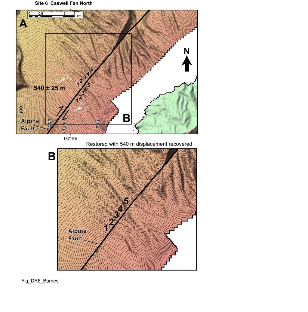
5 Site 5: George South channels (Lat ; Long ) At site 5, about 7 km south of George Sound, the Alpine Fault crosses the upper continental slope about 2.5 km offshore (Fig. DR5). The fault forms a landward-facing scarp about 200 m high. At the head of a prominent slope canyon, in 300 m water depth, two well defined channels are dextrally displaced by the fault. The displacement of each channel axis can be estimated to be 460 ± 40 m. Site 6: Caswell Fan North (Lat ; Long ) The Alpine Fault crosses Caswell Fan in about m water depth off the mouth of Caswell Sound (Fig. 3A). At site 6, the fault displaces a series of exceptionally well preserved, linear aggradational ridges and gullies with about 20 m of relief on the relict glacial outwash surface (Fig. DR6; see also Fig. 5). At this site the vertical displacement is not significant and varies along strike. Seismic profiles show the fault dips steeply towards the coast (Barnes et al., 2005). The relict submarine geomorphology can be perfectly reconstructed after recovery of 540 ± 25 m of dextral displacement (Table DR2). Site 7: Caswell Fan South (Lat ; Long ) About 3-4 km southwest of site 6, the fault crosses similar ridges and gullies on the southern side of Caswell Fan (Fig. DR7). At two separate sites, collectively referred to here as site 7, the fault displaces prominent linear ridges and gullies dextrally by 530 ± 40 m (Table DR2). The ridges and gullies have about m of relief, and can be reconstructed to their original geometry (not shown here). The displacement is constant over the 4 km between the sites. The uncertainty in the displacement is derived primarily from projection of prominent escarpments and gully axes over about 250 m to the fault trace.
6 Site 8: Doubtful Fan Central (Lat ; Long ) The Alpine Fault crosses Doubtful Fan about 10 km off the mouth of Doubtful Sound (Fig. 1A). The fan is about 10 km wide (Barnes et al., 2005). On the centre of the fan at site 8 (Fig. DR8) a series of aggradational ridges and gullies with relief of about 5-15 m are dextrally displaced by 540 ± 30 m (Table DR2). The fault locally forms a landwardfacing scarp as a result of the dextral displacement. There is negligible vertical displacement of the outwash surface, which is convex at the scale of the fan. The estimate of uncertainty in the displacement derives from projection of ridge slopes and gully axes to the fault trace. Site 9: Doubtful Fan South (Lat ; Long ) At site 9 the fault crosses the southern edge of the last glacial surface of Doubtful Fan (Fig. DR9A). The fault trace continues southwest for several kilometers across an elevated and dissected older fan surface, and then along the northwestern margin of Dagg Basin where a releasing bend on the fault results in localized extension and increased vertical displacement (Barnes et al., 2005). The southern edge of Doubtful Fan is characterized by a prominent escarpment up to 70 m high marked by the white dashed line in Fig. DR9A. This escarpment can be reconstructed to a single linear feature after recovery of 520 ± 30 m of dextral displacement (Fig. DR9B). The older dissected fan surface and a prominent ridge on the western side of Doubtful Fan can be reconstructed after recovery of 2225 ± 75 m of dextral displacement on a slip azimuth of 039 (Fig. DR9C). The reconstruction accounts for substantial subsidence in the northern end of Dagg Basin, and realigns elevated features of the old fan surface. Based on the total displacement of 2225 ± 75 m, and the post 17 ka displacement rate
7 (Table DR2), the age of the older fan surface is estimated to be 71 ± 11 kyrs old. This age is consistent with a major glacial advance documented in south Westland by Sutherland et al. (2007). Comparison of Onshore-to-offshore Alpine Fault Slip Rates along Strike between South Westland and Central Fiordland Post-glacial (<20 ka) dextral displacements on the southern, offshore part of the Alpine Fault can be compared with similar aged features along an adjacent 80 km section of the fault on land, south of Jacksons Bay in south Westland (Sutherland et al., 2006a) (Fig. DR1). Whilst there is significant overlap between the ranges of uncertainty from individual sites, a regression line based on the individual displacements, and differences in the weighted mean displacements of three separate groups (south Westland, North group, and South group), indicate an increase in post-glacial displacement to the south. Using the absolute offsets an unpaired Students t-test assuming equal variances indicates a probability (P one tail) of 0.05 (t statistic -1.8, 11 degrees of freedom (df)), indicating that the southward increase in the weighted mean post-glacial displacement, from onshore in South Westland (416 m) to the Milford to George sound shelf (463 m) is significant at the 5 % and 1 % levels. It follows from a similar comparison of the displacements in south Westland and offshore between Caswell and Doubtful sounds (South group) that the latter weighted mean (534 m) is significantly larger (t -7.0, df 10, P one tail 0) at the 1 % level. If we assume all these glacial features are coeval, the displacements indicate that the fault slip rate increases to the south over the km length of the fault between south Westland and the central Fiordland margin.
8 Tables and Figure Captions Table DR1. Radiocarbon dates of submarine glacial outwash fans on the Fiordland continental margin. The samples were recovered from the surface of the fans in seabed cores and dredge samples acquired in 2004 on Tangaroa voyage Tan0405. Shell fragments were identified by Bruce Marshall at Te Papa Tongarewa Museum of New Zealand, and dated by the Institute of Geological & Nuclear Sciences. Table DR2. Post-glacial dextral displacements and slip rate on the southern Alpine Fault. Figure DR1. Site 1. Bathymetric map of a submerged glacial moraine displaced by the Alpine Fault on the inner continental shelf off the northern side of Transit Valley. See Fig. 2B for location of site 1. The bathymetry is developed from 5 m binned, R.V. Tangaroa SIMRAD EM300 multibeam data. Bathymetric contours are at a 2 m interval. Note the extrapolation uncertainties in projecting the crest of the onshore lateral moraine offshore (see also Barnes et al., 2005), and the 500 m wide step-over in the Alpine Fault trace (bold white arrow) which complicates identification of the dextral displacement at this site. Figure DR2. Site 2. A. Bathymetric map of a submerged arcuate glacial moraine displaced by the Alpine Fault on the inner continental shelf off the southern side of Transit Valley. See Fig. 2B for location of site 2. Bathymetry data as in Fig. DR1. The crest and general outline of the moraine are marked by the bold blue and white dashed lines, respectively. The uncertainties in the displacement are indicated by the fine blue
9 dashed lines each side of the crest. B. SIMRAD EM300 multibeam backscatter sonar image revealing the highly reflective nature of the boulder moraine. Figure DR3. Site 3. A. Bathymetric map of a submerged glacial moraine displaced by the Alpine Fault on the inner continental shelf off the northern side of Poison Bay. See Fig. 2B for location of site 3. Bathymetry data as in Fig. DR1. The general outline of the moraine is marked by the bold white dashed line. B. Enlargement showing the displacement and uncertainties of the sharp northern edge of the moraine (see also Fig. 2A). Figure DR4. Site 4. A. Bathymetric map of ridges and gullies at the shelf break, displaced by the Alpine Fault, off the northern side of Sutherland Sound. See Fig. 2B for location of site 4. The bathymetry is developed from 5 m and 25 m binned, R.V. Tangaroa SIMRAD EM300 multibeam data. Bathymetric contours are at a 10 m interval. B. Enlargement showing the displacement and uncertainties of a prominent gully axis. Figure DR5. Site 5. Bathymetric map of the Alpine Fault crossing the upper continental slope about 7 km south of George Sound. The bathymetry is developed from 25 m binned, R.V. Tangaroa SIMRAD EM300 multibeam data. Bathymetric contours are at a 10 m interval. The displacement and uncertainties of two prominent channels are highlighted.
10 Figure DR6. Site 6. A. Bathymetric map of the Alpine Fault crossing the northern part of Caswell Fan. See Figs. 1A and 3A for location. (See also Fig. 4). Bathymetry data as in Fig. DR5. B. Enlargement of geomorphic features on the outwash surface numbered 1 to 5 perfectly reconstructed after recovery of 540 m of dextral displacement. Figure DR7. Site 7. Bathymetric map of the Alpine Fault crossing the southern part of Caswell Fan between Caswell and Charles sounds. Bathymetry data as in Fig. DR5. The displacement and uncertainties of 530 ± 40 m of two sets of ridges and channels about 4 km apart are highlighted. Figure DR8. Site 8. A. Bathymetric map of the Alpine Fault crossing Doubtful Fan off Doubtful Sound. Bathymetry data as in Fig. DR5. The location of Doubtful Sound is shown on Fig. 1A. White arrows indicate the dextral displacement of prominent geomorphology on the outwash surface. B. Reconstruction of the ridges and gullies on the fan surface after recovery of 540 m of dextral displacement. The red dashed and yellow lines show the present day and restored positions of the geomorphic features, respectively, relative to the fan surface east of the fault. Figure DR9. Site 9. A. Bathymetric map of the middle continental slope off Doubtful and Dagg sounds, where the Alpine Fault (red line) crosses the southern edge of last glacial Doubtful Fan and an elevated and dissected older fan surface, and bounds the northwestern margin of Dagg Basin. Bathymetry data as in Fig. DR5. White dashed lines mark the southern edge of the last glacial Doubtful Fan, which is displaced by 520 ± 30
11 m on a slip azimuth of 039. Yellow lines mark an older geomorphic feature on the fan surface displaced by 2225 ± 75 m. B. Reconstruction of the southern edge of Doubtful Fan after recovery of 520 m of dextral displacement. C. Reconstruction of an older fan surface south of the last Glacial Doubtful Fan after recovery of 2225 m of dextral displacement on a slip azimuth of 039.
12 TABLE DR1. RADIOCARBON DATES OF SUBMARINE GLACIAL OUTWASH FANS Sample Water Deposit Location Dated shell Radiocarbon age Calibrated radiocarbon age Number Depth (yr BP) ( yr BP) (m) Lat ( S) Long ( E) Tan0405#41 * Gravel beneath 0.1 m post-glacial sediment Cardita aoteana ± ± 430 (0.39 M) NZA Tan0405#8 Graded gravel beneath 0.9 m postglacial mud (0.95 m) Mytilidae ± ± 510 NZA Tan0405#12 Gravel beneath ± ± 350 (1.1 m) reworked postglacial sediments Maoricolpus roseus NZA Tan0405#53 Mud immediately ± ± 560 (0.43 m) overlying youngest Plantic forams gravel NZA Tan0405#38 Gravel beneath ± ± 500 (0.24 m) reworked postglacial sediments Tawera spissa NZA Tan0405#20 (1.07 m) Surface graded gravel Mytilus galloprovincialis ± ± 200 NZA * National Institute of Water & Atmospheric Research station number. Bracketed number, e.g., (0.39 M), is the sample depth below seabed in sediment core. Rafter Radiocarbon Laboratory code, Institute of Geological & Nuclear Sciences. Calibrated age expressed at 2 sigma confidence level.
13
14 TABLE DR2. DEXTRAL DISPLACEMENTS AND SLIP RATE ON THE SOUTHERN, OFFSHORE ALPINE FAULT Site Displaced markers Location Lat Long ( S) ( E) Age (cal. ka) # C t +ve (cal. ka) C t -ve (cal. ka) Offset (m) C x Slip rate (mm/yr) (m) SR alt 1 SR alt 2 North group (Milford to George sounds) Mean Transit 1 moraine Nth Transit 2 moraine Sth Poison Bay 3 moraine Nth Sutherland 4 channels George Sth 5 channels (-3.9, +2.7) (-2.5, +2.4) (-2.5, +2.9) Standard deviation (MC) Weighted mean (-3.0, +1.8) (±1.0) (-1.5, +1.8) South group (Caswell to Doubtful sound) Caswell Fan Nth ridges & 6 gullies Mean Caswell Fan Sth ridges & gullies Doubtful fan central ridges & gullies Doubtful fan Sth ridge (-3.5, +2.1) (-1.1, +1.2) (-1.9, +2.1) Standard deviation MC Weighted mean (-3.5, +2.1) (±1.1) (-1.9, +2.1) # Adopted age for glacial features considering dated samples in Table DR1 and published regional data on glacial advances. C t +ve Upper confidence interval in adopted glacial age; C t -ve Lower confidence interval in adopted glacial age. C x Offset confidence interval half-width. All slip rate uncertainties are derived from combined Monte-Carlo simulations of normal distributions of the individual offsets and the respective age models (with 1500 random simulations in each distribution), and are expressed at the 95% confidence level. SR alt 1 Alternative estimate of slip rate using the first five actual shell ages (mean age 16.7 cal. ka) in Table DR1, as indicative of the glacial geomorphic age. SR alt 2 Alternative estimate of slip rate for 18 ± 1 cal. ka glacial age model (Sutherland et al. 2006). Standard deviation (MC) derived from the Monte-Carlo simulations of the offsets. Weighted mean follows method of Sutherland et al. (2006), whereby weighting contributions account for level of measurement precision, i.e., displacement measurements with lower uncertainty carry more weight in the mean.

15
16

17

18

19
20

21

22

23
Sutherland et al: Glacial chronology, NZ
 Orbital forcing of mid-latitude southern hemisphere glaciation since 100 ka, inferred from cosmogenic nuclide ages of moraine boulders from the Cascade Plateau, southwest New Zealand Rupert Sutherland
DETAILS OF CATCHMENTS STUDIED
 GSA Data Data Repository itemitem 2006048 DETAILS OF CATCHMENTS STUDIED 0 10 20 km Jacksons Bay Cascade River A Martyr R. Jerry R. B Cascade River Hokuri Creek, North Hokuri Creek, South Lake McKerrow
Ocean Basins, Bathymetry and Sea Levels
 Ocean Basins, Bathymetry and Sea Levels Chapter 4 Please read chapter 5: sediments for next class and start chapter 6 on seawater for Thursday Basic concepts in Chapter 4 Bathymetry the measurement of
Map shows 3 main features of ocean floor
 Map shows 3 main features of ocean floor 2017 Pearson Education, Inc. Chapter 3 Marine Provinces 2017 Pearson Education, Inc. 1 Chapter 3 Overview The study of bathymetry determines ocean depths and ocean
Chapter Overview. Bathymetry. Measuring Bathymetry. Measuring Bathymetry
 CHAPTER 3 Marine Provinces Chapter Overview The study of bathymetry determines ocean depths and ocean floor topography. Echo sounding and satellites are efficient bathymetric tools. Most ocean floor features
Bathymetry Measures the vertical distance from the ocean surface to mountains, valleys, plains, and other sea floor features
 1 2 3 4 5 6 7 8 9 10 11 CHAPTER 3 Marine Provinces Chapter Overview The study of bathymetry determines ocean depths and ocean floor topography. Echo sounding and satellites are efficient bathymetric tools.
4. The map below shows a meandering stream. Points A, B, C, and D represent locations along the stream bottom.
 1. Sediment is deposited as a river enters a lake because the A) velocity of the river decreases B) force of gravity decreases C) volume of water increases D) slope of the river increases 2. Which diagram
FOOT OF THE CONTINENTAL SLOPE IN ARTICLE 76
 FOOT OF THE CONTINENTAL SLOPE IN ARTICLE 76 Vaughan Stagpoole, Institute of Geological & Nuclear Sciences, Lower Hutt, New Zealand, v.stagpoole@gns.cri.nz Ray Wood, Institute of Geological & Nuclear Sciences,
Offshore Evidence for Uplift Rate Boundaries. Hans AbramsonWard Diablo Canyon SSHAC SSC Workshop 2 November 7, 2012
 Offshore Evidence for Uplift Rate Boundaries Hans AbramsonWard Diablo Canyon SSHAC SSC Workshop 2 November 7, 2012 Questions asked by the TI team Discuss your ability to distinguish and correlate offshore
DATA REPOSITORY MATERIAL: PALEOCHANNEL GROUP MAPPING DESCRIPTIONS
 Data Repository item 2695 DATA REPOSITORY MATERIAL: PALEOCHANNEL GROUP MAPPING DESCRIPTIONS Groups 1 (North Myrtle Beach) and 2 (Atlantic Beach) Channel Groups 1 (North Myrtle Beach) and 2 (Atlantic Beach)
Lecture Marine Provinces
 Lecture Marine Provinces Measuring bathymetry Ocean depths and topography of ocean floor Sounding Rope/wire with heavy weight Known as lead lining Echo sounding Reflection of sound signals 1925 German
2.2.7 Backbarrier flats
 FIGURE 24. VERTICAL PHOTOGRAPH SHOWING THE DEVELOPMENT OF SMALL PARABOLIC DUNES FROM BLOWOUTS IN A LARGE RELICT FOREDUNE NORTHWEST OF HUNTER'S CREEK. PHOTOGRAPH COURTESY OF CAR'T'ER HOLT HARVEY FORESTS
Supplementary Material
 GSA Data Repository item 2018118 Brardinoni, F., Picotti, V., Maraio, S., Paolo Bruno, P., Cucato, M., Morelli, C., and Mair, V., 2018, Postglacial evolution of a formerly glaciated valley: Reconstructing
8.0 SUMMARY AND CONCLUSIONS
 8.0 SUMMARY AND CONCLUSIONS In November 2008, Pacific Gas and Electric (PG&E) informed the U.S. Nuclear Regulatory Commission (NRC) that preliminary results from the Diablo Canyon Power Plant (DCPP) Long
discussion of North America s physical features, including its landforms and bodies of
 Chapter 7 Natural Environments of North America Chapter 7 focuses on the natural environments of North America. The chapter opens with a discussion of North America s physical features, including its landforms
Moosehead Lake and the Tale of Two Rivers
 Maine Geologic Facts and Localities June, 2005 45 o 53 5.09 N, 69 o 42 14.54 W Text by Kelley, A.R.; Kelley, J.T.; Belknap, D.F.; and Gontz, A.M. Department of Earth Sciences, University of Maine, Orono,
Chapter 2. Wearing Down Landforms: Rivers and Ice. Physical Weathering
 Chapter 2 Wearing Down Landforms: Rivers and Ice Physical Weathering Weathering vs. Erosion Weathering is the breakdown of rock and minerals. Erosion is a two fold process that starts with 1) breakdown
24. Ocean Basins p
 24. Ocean Basins p. 350-372 Background The majority of the planet is covered by ocean- about %. So the majority of the Earth s crust is. This crust is hidden from view beneath the water so it is not as
4.3. Geomorphologic route along the Urasalakh River
 The Expedition Lena-Anabar 2003 4 Periglacial studies around Cape Mamontov Klyk 4.3. Geomorphologic route along the Urasalakh River Dimitri Bolshiyanov and Alexander Makarov 4.3.1 Structure of Quaternary
Earth / Environmental Science. Ch. 14 THE OCEAN FLOOR
 Earth / Environmental Science Ch. 14 THE OCEAN FLOOR The Blue Planet Nearly 70% of the Earth s surface is covered by the global ocean It was not until the 1800s that the ocean became an important focus
Seafloor Morphology. Techniques of Investigation. Bathymetry and Sediment Studies
 Seafloor Morphology I f we select a grid for the surface of the earth (i.e. 5 km 2 ) and assign it an average elevation in relation to sea level, we can construct a graph of elevation versus area of the
THE QUATERNARY GEOLOGY OF NEWARK BAY AND KILL VAN KULL CHANNEL, NEW YORK AND NEW JERSEY. and
 THE QUATERNARY GEOLOGY OF NEWARK BAY AND KILL VAN KULL CHANNEL, NEW YORK AND NEW JERSEY Stephanie Beda, W. Bruce Ward, William Murphy, Robert Fleming, Gary Fleming, Beckett Boyd Earthworks LLC 27 Glen
MARINE GEOLOGY & GEOGRAPHY
 MARINE GEOLOGY & GEOGRAPHY Bathymetry BATHYMETRY BATHYMETRY THE UNDERWATER EQUIVALENT TO TOPOGRAPHY THE STUDY OF WATER DEPTH A BATHYMETRIC MAP SHOWS FLOOR RELIEF OR TERRAIN AS CONTOUR LINES Bathymetry
The Building of the NYC Region
 The Building of the NYC Region Definitions Fall Line marks the area where an upland region (continental bedrock) and a coastal plain meet Piedmont the plateau region of the eastern United States which
[ ] Appendix A : Dating results and associated figures. Table A1. Analytical results of cosmogenic dating of 29 samples at site 1.
![[ ] Appendix A : Dating results and associated figures. Table A1. Analytical results of cosmogenic dating of 29 samples at site 1.](/thumbs/84/90992034.jpg "[ ] Appendix A : Dating results and associated figures. Table A1. Analytical results of cosmogenic dating of 29 samples at site 1.") Geophysical Journal International 2002, 147: 356-388. Supplementary material to Van Der Woerd J., P. Tapponnier, F.J. Ryerson, A.S. Mériaux, B. Meyer, Y. Gaudemer, R. Finkel, M. Caffee, Zhao G., Xu Z.,
Geophysical Journal International 2002, 147: 356-388. Supplementary material to Van Der Woerd J., P. Tapponnier, F.J. Ryerson, A.S. Mériaux, B. Meyer, Y. Gaudemer, R. Finkel, M. Caffee, Zhao G., Xu Z.,
In 1990, 50% of the U.S. population lived within 75 km of a coast. By 2010, 75% of the U.S. population will live within 75 km of a coast.
 In 1990, 50% of the U.S. population lived within 75 km of a coast. By 2010, 75% of the U.S. population will live within 75 km of a coast. High Tech Methods for Surveying the Deep Sea Floor Fig. 20.18 1
Answers: Internal Processes and Structures (Isostasy)
") Answers: Internal Processes and Structures (Isostasy) 1. Analyse the adjustment of the crust to changes in loads associated with volcanism, mountain building, erosion, and glaciation by using the concept
Answers: Internal Processes and Structures (Isostasy) 1. Analyse the adjustment of the crust to changes in loads associated with volcanism, mountain building, erosion, and glaciation by using the concept
Small area of the ocean that is partially surrounded by land. The Ocean Basins. Three Major Oceans. Three Major Oceans. What is a SEA?
 The Ocean Basins How Deep is the Ocean? 1 2 Three Major Oceans Three Major Oceans Pacific Atlantic the shallowest ocean (3.3km average depth) Indian second shallowest ocean (3.8km average depth) Pacific
1. Name at least one place that the mid-atlantic Ridge is exposed above sea level.
 Interpreting Tectonic and Bathymetric Maps. The purpose of this lab is to provide experience interpreting the bathymetry of the seafloor in terms of tectonic and geologic settings and processes. Use the
Ocean Floor. Continental Margins. Divided into 3 major regions. Continental Margins. Ocean Basins. Mid-Ocean Ridges. Include:
 Ocean Floor Divided into 3 major regions Continental Margins Ocean Basins Mid-Ocean Ridges Continental Margins Include: Continental Shelves Continental Slopes Continental Rise 1 Continental Shelves Part
ANALYSIS OF SEISMIC PROFILES AND SIDE-SCAN SONAR RECORDS FROM LOWER NEW YORK HARBOR, A PROGRESS REPORT. Roger D. Flood Vicki Lynn Ferrini
 45 ANALYSIS OF SISMIC PROFILS AND SID-SCAN SONAR RCORDS FROM LOWR NW YORK HARBOR, A PROGRSS RPORT Roger D. Flood Vicki Lynn Ferrini Marine Sciences Research Center State University of New York, Stony Brook,
 Page 1 of 9 Name: Base your answer to the question on the diagram below. The arrows show the direction in which sediment is being transported along the shoreline. A barrier beach has formed, creating a
The Ocean Floor Earth Science, 13e Chapter 13
 The Ocean Floor Earth Science, 13e Chapter 13 Stanley C. Hatfield Southwestern Illinois College The vast world ocean Earth is often referred to as the blue planet Seventy-one percent of Earth s surface
Continental Landscapes
 Continental Landscapes Landscape influenced by tectonics, climate & differential weathering Most landforms developed within the last 2 million years System moves toward an equilibrium Continental Landscapes
USU 1360 TECTONICS / PROCESSES
 USU 1360 TECTONICS / PROCESSES Observe the world map and each enlargement Pacific Northwest Tibet South America Japan 03.00.a1 South Atlantic Arabian Peninsula Observe features near the Pacific Northwest
2013 SCEC Annual Report
 2013 SCEC Annual Report Collaborative research: Documentation of Tsunami Deposits in the Carpinteria Estuary: A signal of Great Earthquakes on the Pitas Point Thrust L. Reynolds, A. Simms, T.K. Rockwell,
Form 4 of Schedule 5 of the Exclusive Economic Zone and Continental Shelf (Environmental Effects Permitted Activities) Regulations 2013
 Regulations 2013") FORM 4 Permitted activities: Post-activity report Form 4 of Schedule 5 of the Exclusive Economic Zone and Continental Shelf (Environmental Effects Permitted Activities) Regulations 2013 How to use this
FORM 4 Permitted activities: Post-activity report Form 4 of Schedule 5 of the Exclusive Economic Zone and Continental Shelf (Environmental Effects Permitted Activities) Regulations 2013 How to use this
Reading Material. See class website. Sediments, from Oceanography M.G. Gross, Prentice-Hall
 Reading Material See class website Sediments, from Oceanography M.G. Gross, Prentice-Hall Materials filling ocean basins Dissolved chemicals especially from rivers and mid-ocean ridges (volcanic eruptions)
Iceberg Plough Marks in the Vicinity of the Norwegian Trough
 Iceberg Plough Marks in the Vicinity of the Norwegian Trough ROBERT H. BELDERSON & JOHN B. WILSON Belderson, R. H. & Wilson, J. B.: Iceberg plough marks in the vicinity of the Norwegian Trough. Norsk Geologisk
Quaternary slip rate and geomorphology of the Alpine fault: Implications for kinematics and seismic hazard in southwest New Zealand
 Quaternary slip rate and geomorphology of the Alpine fault: Implications for kinematics and seismic hazard in southwest New Zealand Rupert Sutherland Kelvin Berryman Institute of Geological and Nuclear
2) re-positioning of the SSS data, 3) individuation of geomorphological features and morphometrical parameters correlated to instability phenomena.
 re-positioning of the SSS data, 3) individuation of geomorphological features and morphometrical parameters correlated to instability phenomena.") HIGH-RESOLUTION SIDE SCAN SONAR AND MULTIBEAM DATA PROCESSING AND MERGING TO STUDY SUBMARINE INSTABILITY PHENOMENA ON VOLCANIC ISLANDS (PONTINE, CAMPANIAN AND AEOLIAN ARCHIPELAGOS) A. BOSMAN Extended abstract:
HIGH-RESOLUTION SIDE SCAN SONAR AND MULTIBEAM DATA PROCESSING AND MERGING TO STUDY SUBMARINE INSTABILITY PHENOMENA ON VOLCANIC ISLANDS (PONTINE, CAMPANIAN AND AEOLIAN ARCHIPELAGOS) A. BOSMAN Extended abstract:
Earth s Continents and Seafloors. GEOL100 Physical Geology Ray Rector - Instructor
 Earth s Continents and Seafloors GEOL100 Physical Geology Ray Rector - Instructor OCEAN BASINS and CONTINENTAL PLATFORMS Key Concepts I. Earth s rocky surface covered by of two types of crust Dense, thin,
The Ocean Floor Chapter 14. Essentials of Geology, 8e. Stan Hatfield and Ken Pinzke Southwestern Illinois College
 The Ocean Floor Chapter 14 Essentials of Geology, 8e Stan Hatfield and Ken Pinzke Southwestern Illinois College The vast world ocean Earth is often referred to as the water planet 71% of Earth s surface
THE TOPOGRAPHY AND GEOLOGY OF THE GRAND PORTAGE^
 THE TOPOGRAPHY AND GEOLOGY OF THE GRAND PORTAGE^ Few areas within the boundaries of Minnesota are of greater historical interest than the region surrounding the Grand Portage, which long before the first
Geol 117 Lecture 18 Beaches & Coastlines. I. Types of Coastlines A. Definition:
 I. Types of Coastlines A. Definition: 1. Shore = narrow zone where ocean meets land (e.g. beach) 2. Coast is a broad area where both ocean and land processes act a. Includes onshore marshes, dunes, sea
General Geologic Setting and Seismicity of the FHWA Project Site in the New Madrid Seismic Zone
 General Geologic Setting and Seismicity of the FHWA Project Site in the New Madrid Seismic Zone David Hoffman University of Missouri Rolla Natural Hazards Mitigation Institute Civil, Architectural & Environmental
Lecture Outlines PowerPoint. Chapter 13 Earth Science 11e Tarbuck/Lutgens
 Lecture Outlines PowerPoint Chapter 13 Earth Science 11e Tarbuck/Lutgens 2006 Pearson Prentice Hall This work is protected by United States copyright laws and is provided solely for the use of instructors
Oceanography. Oceanography is the study of the deep sea and shallow coastal oceans.
 Oceanography Oceanography is the study of the deep sea and shallow coastal oceans. Studying the Ocean Floor To determine the shape and composition of the ocean floor, scientists use techniques such as
MARINE GEOLOGY & GEOGRAPHY
 MARINE GEOLOGY MARINE GEOLOGY & GEOGRAPHY Marine Geology 4 LAYERS OF THE EARTH CRUST THICKNESS: VARIES BETWEEN OCEAN & CONTINENTS 5-40 KM STATE: SOLID ELEMENTS: SILICON, ALUMINUM, CALCIUM, SODIUM, POTASSIUM
Correlation of gravel deposits from trenching project on Alder Creek fluvial terrace near Point Arena, California
 Correlation of gravel deposits from trenching project on Alder Creek fluvial terrace near Point Arena, California Aletha Lee Department of Geology and Geography, West Virginia University, White Hall, Morgantown,
Directed Reading. Section: The Water Planet. surface is called the a. Earth s ocean. b. Pacific Ocean. c. salt-water ocean. d. global ocean.
 Skills Worksheet Directed Reading Section: The Water Planet 1. The body of salt water covering nearly three-quarters of the Earth s surface is called the a. Earth s ocean. b. Pacific Ocean. c. salt-water
Figure 1. Map of Feather River Basin in northern California. (A) Region straddles the northwestern Sierra Nevada and Sacramento Valley.
 Region straddles the northwestern Sierra Nevada and Sacramento Valley.") Figure 1. Map of Feather River Basin in northern California. (A) Region straddles the northwestern Sierra Nevada and Sacramento Valley. (B) Feather River Basin with Yuba and Bear subbasins. Most hydraulic
Figure 1. Map of Feather River Basin in northern California. (A) Region straddles the northwestern Sierra Nevada and Sacramento Valley. (B) Feather River Basin with Yuba and Bear subbasins. Most hydraulic
SHORELINE AND BEACH PROCESSES: PART 2. Implications for Coastal Engineering
 SHORELINE AND BEACH PROCESSES: PART 2 Implications for Coastal Engineering Objectives of the lecture: Part 2 Show examples of coastal engineering Discuss the practical difficulties of ocean engineering
THE JUAN DE FUCA LOBE OF THE CORDILLERAN ICE SHEET
 THE JUAN DE FUCA LOBE OF THE CORDILLERAN ICE SHEET There were two large glaciers in western Washington during the latest, or Vashon, glaciation of that region. Each was essentially an elongated lobe of
Supplementary Fig. 1. Locations of thinning transects and photos of example samples. Mt Suess/Gondola Ridge transects extended metres above
 Supplementary Fig. 1. Locations of thinning transects and photos of example samples. Mt Suess/Gondola Ridge transects extended 260 24 metres above the modern surface of Mackay Glacier, and included 16
Infilled Kettle Hole, Easton, Aroostook County, Maine
 Maine Geologic Facts and Localities June, 1997, Maine 46 41 26.40 N, 67 48 35.74 W Text by Tom Weddle, Department of Agriculture, Conservation & Forestry 1 Introduction As the last continental glacier
The 1700/01/26 Cascadia subduction zone Earthquake and Tsunami
 Jason R. Patton GEO 142 1/13/15 Abstract: Cascadia subduction zone earthquakes (CSZ) can generate strong ground shaking and deadly tsunamis. Geologists used sediment cores and stream bank exposures to
1. Any process that causes rock to crack or break into pieces is called physical weathering. Initial product = final product
 Weathering 1. Any process that causes rock to crack or break into pieces is called physical weathering. Initial product = final product End Result of physical weathering is increased surface area. 2. Physical
Fig Available seismic reflection, refraction, and magnetic profiles from 107 the Offshore Indus Basin close to the representative profile GCDH,
 List of Figures Page No. Fig. 1.1 Generalized physiography of the Indian Ocean along with 2 selected (200 m, 1000 m, 2000 m, and 3000 m) bathymetric contours. Fig. 1.2 Lithospheric plates in the Indian
High-resolution Geophysical Mapping of Submarine Glacial Landforms
 High-resolution Geophysical Mapping of Submarine Glacial Landforms M. Jakobsson 1, J.A. Dowdeswell 2, M. Canals 3, B.J. Todd 4, E.K. Dowdeswell 2, K.A. Hogan 5 L.A. Mayer 6 1 Stockholm University, Sweden
ARE YOU READY TO THINK? Look at the first slide THINK PAIR SHARE!
 ARE YOU READY TO THINK? Look at the first slide THINK PAIR SHARE! WHAT PROMINENT FEATURE CAN YOU IDENTIFY IN THIS PICTURE? What do you think the different colors represent? Who might find such a picture
Last Time. Submarine Canyons and Fans. Turbidites. MAS 603: Geological Oceanography. Lecture 16: Greenhouse vs. Icehouse Earths
 UNIVERSITY OF SOUTH ALABAMA Last Time MAS 603: Geological Oceanography Lecture 16: Greenhouse vs. Icehouse Earths Submarine Fans Definition and morphology Transport mechanisms (density currents) Submarine
Which landscape best represents the shape of the valleys occupied by glaciers? A) B) C) D)
 B) C) D)") 1. Glaciers often form parallel scratches and grooves in bedrock because glaciers A) deposit sediment in unsorted piles B) deposit rounded sand in V-shaped valleys C) continually melt and refreeze D) drag
1. Glaciers often form parallel scratches and grooves in bedrock because glaciers A) deposit sediment in unsorted piles B) deposit rounded sand in V-shaped valleys C) continually melt and refreeze D) drag
2. Tsunami Source Details
 2. Tsunami Source Details The Northland area faces a range of potential tsunamigenic sources that include several local and distant fault systems and underwater landslides. A NIWA study (Goff et al. 2006)
EXTERNAL LAND FORMING PROCESSES
 NAME SCHOOL INDEX NUMBER DATE EXTERNAL LAND FORMING PROCESSES WEATHERING 1 1998 Q 7 (a) (i) What is the difference between weathering and mass wasting (ii) List five processes involved in chemical weathering
BLAKENEY ESKER AND HOW IT FORMED. The Blakeney Esker is a ridge, around 3.5 km in length, which runs southeastwards
 BLAKENEY ESKER AND HOW IT FORMED Introduction The Blakeney Esker is a ridge, around 3.5 km in length, which runs southeastwards from west of Blakeney, to Wiveton Downs, north-west of Glandford, in north
Divergent Boundaries: Origin and Evolution of the Ocean Floor Earth - Chapter 13 Stan Hatfield Southwestern Illinois College
 Divergent Boundaries: Origin and Evolution of the Ocean Floor Earth - Chapter 13 Stan Hatfield Southwestern Illinois College Mapping the Ocean Floor Depth was originally measured by lowering weighted lines
Plate Tectonics - Demonstration
 Name: Reference: Prof. Larry Braile - Educational Resources Copyright 2000. L. Braile. Permission granted for reproduction for non-commercial uses. http://web.ics.purdue.edu/~braile/indexlinks/educ.htm
Lake Levels and Climate Change in Maine and Eastern North America during the last 12,000 years
 Maine Geologic Facts and Localities December, 2000 Lake Levels and Climate Change in Maine and Eastern North America during the last 12,000 years Text by Robert A. Johnston, Department of Agriculture,
Lab 12 Coastal Geology
 Lab 12 Coastal Geology I. Fluvial Systems Hydrologic Cycle Runoff that flows into rivers = precipitation (rain and snowmelt) [infiltration (loss to groundwater) + evaporation (loss to atmosphere) + transpiration
Lecture 10 Glaciers and glaciation
 Lecture 10 Glaciers and glaciation Outline Importance of ice to people! Basics of glaciers formation, classification, mechanisms of movement Glacial landscapes erosion and deposition by glaciers and the
HYDROGEOLOGIC FRAMEWORK OF LONG ISLAND'S NORTH FORK, SUFFOLK COUNTY, NEW YORK
 HYDROGEOLOGIC FRAMEWORK OF LONG ISLAND'S NORTH FORK, SUFFOLK COUNTY, NEW YORK Christopher E. Schubert 1, Richard E. Bova 2, and Paul E. Misut 1 1 U.S. Geological Survey, 2045 Route 112, Building 4, Coram,
Natural hazards in Glenorchy Summary Report May 2010
 Natural hazards in Glenorchy Summary Report May 2010 Contents Glenorchy s hazardscape Environment setting Flood hazard Earthquakes and seismic hazards Hazards Mass movement Summary Glossary Introduction
Facies Reconstruction of a Late Pleistocene Cypress Forest Discovered on the Northern Gulf of Mexico Continental Shelf
 Facies Reconstruction of a Late Pleistocene Cypress Forest Discovered on the Northern Gulf of Mexico Continental Shelf Suyapa Gonzalez 1, Samuel J. Bentley, Sr. 1, Kristine L. DeLong 3, Kehui Xu 2, Jeffrey
Changes in bottom morphology of Long Island Sound near Mount Misery Shoal as observed through Repeated Multibeam Surveys
 Changes in bottom morphology of Long Island Sound near Mount Misery Shoal as observed through Repeated Multibeam Surveys Laurie A. Zaleski Laurie.Zaleski@msrc.sunysb.edu Roger D. Flood rflood@notes.cc.sunysb.edu
Seafloor Evidence of Remotely Triggered Slope Failures & Turbidity Currents. Paul Johnson, Joan Gomberg, Susan Hautala, and Marie Salmi
 Seafloor Evidence of Remotely Triggered Slope Failures & Turbidity Currents Paul Johnson, Joan Gomberg, Susan Hautala, and Marie Salmi Why Do We Care? The turbidite record is a key constraint on recurrence
Oceanography, An Invitation to Marine Science 9e Tom Garrison. Ocean Basins Cengage Learning. All Rights Reserved.
 Oceanography, An Invitation to Marine Science 9e Tom Garrison 4 Ocean Basins Key Concepts Tectonic forces shape the seabed The ocean floor is divided into continental margins and deep ocean basins The
Foundations of Earth Science, 6e Lutgens, Tarbuck, & Tasa
 Foundations of Earth Science, 6e Lutgens, Tarbuck, & Tasa Oceans: The Last Frontier Foundations, 6e - Chapter 9 Stan Hatfield Southwestern Illinois College The vast world ocean Earth is often referred
DANCORE-Day. Master s Thesis
 DANCORE-Day Master s Thesis Interpretation of Shallow Seismic and Sediment Cores from the Area stretching from the Southern Part of Kattegat to the Great Belt in the Period Late-Weichselian to Early Holocene.
The Monterey Submarine Canyon and Fan
 Chapter 72 The Monterey Submarine Canyon and Fan Monterey Canyon, California, is probably the most studied submarine canyon in the world (Figure 72.1). Since it is typical of many others it is useful as
CORRELATION OF CLIMATIC AND SOLAR VARIATIONS OVER THE PAST 500 YEARS AND PREDICTING GLOBAL CLIMATE CHANGES FROM RECURRING CLIMATE CYCLES
 Easterbrook, D.J., 2008, Correlation of climatic and solar variations over the past 500 years and predicting global climate changes from recurring climate cycles: International Geological Congress, Oslo,
Outline 23: The Ice Ages-Cenozoic Climatic History
 Outline 23: The Ice Ages-Cenozoic Climatic History Continental Glacier in Antarctica Valley Glaciers in Alaska, note the moraines Valley Glaciers in Alaska, note the moraines Mendenhall Glacier, Juneau,
Surface Process Hazards Unit 2: Landscape Feature Scavenger Hunt
 Surface Process Hazards Unit 2: Landscape Feature Scavenger Hunt Sarah Hall (College of the Atlantic) and Becca Walker (Mt. San Antonio College) The following pages each have a series of questions about
CHAPTER 28. PHYSIOGRAPHY Cook Inlet Drainages
 PEBBLE PROJECT ENVIRONMENTAL BASELINE DOCUMENT 2004 through 2008 CHAPTER 28. PHYSIOGRAPHY Cook Inlet Drainages PREPARED BY: Knight Piésold Ltd. PHYSIOGRAPHY COOK INLET DRAINAGES TABLE OF CONTENTS TABLE
Why is Sebago Lake so deep?
 Maine Geologic Facts and Localities February, 1999 Why is Sebago Lake so deep? 43 51 13.36 N, 70 33 43.98 W Text by Robert A. Johnston, Department of Agriculture, Conservation & Forestry 1 Introduction
Essential Questions. What is erosion? What is mass wasting?
 Erosion Essential Questions What is erosion? What is mass wasting? What is Erosion? Erosion The transportation of sediment from one area to another Caused mainly by running water but also caused by glaciers,
Marine Science and Oceanography
 Marine Science and Oceanography Marine geology- study of the ocean floor Physical oceanography- study of waves, currents, and tides Marine biology study of nature and distribution of marine organisms Chemical
Digital Elevation Model (DEM) of Sable Island Bank and adjacent areas
 of Sable Island Bank and adjacent areas") GEOLOGICAL SURVEY OF CANADA OPEN FILE 5348 Digital Elevation Model (DEM) of Sable Island Bank and adjacent areas K.J. Webb and E.L. King 2014 GEOLOGICAL SURVEY OF CANADA OPEN FILE 5348 Digital Elevation
GEOLOGICAL SURVEY OF CANADA OPEN FILE 5348 Digital Elevation Model (DEM) of Sable Island Bank and adjacent areas K.J. Webb and E.L. King 2014 GEOLOGICAL SURVEY OF CANADA OPEN FILE 5348 Digital Elevation
Description of faults
 GLG310 Structural Geology Description of faults Horizontal stretch Crustal thickness Regional elevation Regional character Issues Normal Thrust/reverse Strike-slip >1 1 in one direction and < 1 in
FINMARINET: Inventories and Planning for the Marine Natura 2000 Network in Finland. A.2 Geological inventories of the seafloor Final Report
 LIFE07 NAT/FIN/000151 FINMARINET: Inventories and Planning for the Marine Natura 2000 Network in Finland A.2 Geological inventories of the seafloor Final Report Geological Survey of Finland, GTK 1. Introduction
Name: Mid-Year Review #2 SAR
 Name: Mid-Year Review #2 SAR Base your answers to questions 1 through 3 on on the diagram below, which shows laboratory materials used for an investigation of the effects of sediment size on permeability,
4. Regions Northland Region Distant Eastern source: South America (Chile/Peru)
") 4. Regions Maximum water surface elevation images are presented below for tsunamis generated from the sources discussed above; Distant Eastern source: South America (Chile/Peru), Regional Eastern source:
4. Regions Maximum water surface elevation images are presented below for tsunamis generated from the sources discussed above; Distant Eastern source: South America (Chile/Peru), Regional Eastern source:
The Marine Environment
 The Marine Environment SECTION 16.1 Shoreline Features In your textbook, read about erosional landforms, beaches, estuaries, longshore currents, and rip currents. For each statement below, write or. 1.
Continental Margin Geology of Korea : Review and constraints on the opening of the East Sea (Japan Sea)
") Continental Margin Geology of Korea : Review and constraints on the opening of the East Sea (Japan Sea) Han-Joon Kim Marine Satellite & Observation Tech. Korea Ocean Research and Development Institute
Continental Margin Geology of Korea : Review and constraints on the opening of the East Sea (Japan Sea) Han-Joon Kim Marine Satellite & Observation Tech. Korea Ocean Research and Development Institute
Earth in 2-D, 3-D & 4-D
 Earth in 2-D, 3-D & 4-D We will consider the scientific tools and techniques used to map surface features, reconstruct the layered structure of Earth, and interpret Earth history, including the origin
Linking surficial geomorphology with vertical structure in high and low energy marine
 Linking surficial geomorphology with vertical structure in high and low energy marine environments Erica Sampaga 1 Advisors: Miles Logsdon, Emily Roland 1 University of Washington, School of Oceanography
Chapter 02 The Sea Floor
 Chapter 02 The Sea Floor Multiple Choice Questions 1. One of the following is not one of the world's major ocean basins: A. Atlantic Ocean B. Arctic Ocean C. Indian Ocean D. Antarctic Ocean E. Pacific
Extra Credit Assignment (Chapters 4, 5, 6, and 10)
") GEOLOGY 306 Laboratory Instructor: TERRY J. BOROUGHS NAME: Extra Credit Assignment (Chapters 4, 5, 6, and 10) For this assignment you will require: a calculator and metric ruler. Chapter 4 Objectives:
GEOLOGY 306 Laboratory Instructor: TERRY J. BOROUGHS NAME: Extra Credit Assignment (Chapters 4, 5, 6, and 10) For this assignment you will require: a calculator and metric ruler. Chapter 4 Objectives:
Red Sea Coast of Egypt. by Prof.. Dr. Abbas Mansour
 Red Sea Coast of Egypt by Prof.. Dr. Abbas Mansour INTRODUCTION The Red Sea extends northwestward from the narrow strait of Bab ElMandab to the southern tip of Sinai, Egypt. The zone where land and sea
In this lab, we will study and analyze geologic maps from a few regions, including the Grand Canyon, western Wyoming, and coastal California.
 Name: Lab Section: work in groups, but each person turns in his/her own GEOSCIENCE 001 LAB UNDERSTANDING GEOLOGIC MAPS Geologic maps are colorful and even beautiful, but they also contain an amazing amount