Elm Coulee Oil Field Richland County, Montana. Bakken Oil Well FRAC TREATMENT
|
|
|
- Justina Cole
- 6 years ago
- Views:
Transcription

1 Elm Coulee Oil Field Richland County, Montana Bakken Oil Well FRAC TREATMENT
2 LOCATION MAP ELM COULEE FIELD RICHLAND COUNTY, MONTANA SASKATCHEWAN MANITOBA WILLISTON BASIN Poplar Dome Nesson Ant Brockton-Froid FZ MONTANA WYOMING Elm Coulee Cedar Cr Ant Little Knife Ant. Billings Ant NORTH DAKOTA SOUTH DAKOTA Modified after Heck, R. LeFever, Fischer, and J. LeFever


3 STRATIGRAPHIC COLUMN WILLISTON BASIN BAKKEN Modified after Heck, R. LeFever, Fischer, and J. LeFever
4 LOCATION MAP ORIGINAL TYPE LOG Bakken Formation SASKATCHEWAN MANITOBA WILLISTON BASIN Poplar Dome Nesson Ant TYPE LOG Brockton-Froid FZ Elm Coulee Cedar Cr Ant Little Knife Ant. Billings Ant NORTH DAKOTA MONTANA SOUTH DAKOTA WYOMING Modified after Heck, R. LeFever, Fischer, and J. LeFever
5 ORIGINAL TYPE LOG NORTH DAKOTA Gamma Ray (arg./organic content) Neutron (porosity) UPPER ORGANIC-RICH SHALE MEMBER MIDDLE MEMBER (Sandst, Sltst, Carb, var argill.) BAKKEN 110 FT. LOWER ORGANIC-RICH SHALE MEMBER (SANISH) Modified after J. LeFever
6 Bakken Formation Williston Basin SASKATCHEWAN MANITOBA Member Extents: UPPER SHALE MIDDLE MEMBER LOWER SHALE Nesson Ant Elm Coulee Bakken Type Log Antelope Cross-Section OVER-PRESSURED AREA NORTH DAKOTA MONTANA WYOMING WILLISTON BASIN SOUTH DAKOTA WEST Elm Coulee Area SCHEMATIC STRUCTURAL CROSS-SECTION Three Forks fm (Dev) Nesson Anticline Antelope Field Lodgepole fm (Miss) Three Forks fm (Dev) EAST Modified after Meissner (1978)
7 WILLISTON BASIN Bakken Productive Areas SASKATCHEWAN MANITOBA WILLISTON BASIN Poplar Dome Nesson Ant Brockton-Froid FZ Elm Coulee Cedar Cr Ant Billings Ant Little Knife Ant. NORTH DAKOTA MONTANA WYOMING PRINCIPAL BAKKEN PRODUCING AREAS SOUTH DAKOTA through 1986 Vertical - fractures through 1999 Horizontal & Vertical - fractures Current Development Horizontal - Matrix Porosity & fractures
8 100,000,000 WILLISTON BASIN MULTIPLE - - MULTIPLE FIELD - MULTIPLE - 67,552,614 bbl Cum Oil Bakken (& Sanish ) Production to Late ,000,000 VERTICAL DRILLING HORIZONTAL DRILLING 1,000,000 Production Rates (BOPM, MCFGPM) 100,000 10,000 1,000 Oil Production (bbl) Gas Production (mcf) Oil Production (bbl) Gas Production (mcf) Water Production (bbl) Historical Well Counts Cumulative Oil (bbl) Water Production (bbl) ELM COULEE DISCOVERY Time
9 TYPE LOGS LOCATION MAP WILLISTON BASIN SASKATCHEWAN MANITOBA WILLISTON BASIN Poplar Dome Nesson Ant Bakken Type Log (Modern) Brockton-Froid FZ Elm Coulee Cedar Cr Ant Little Knife Ant. Billings Ant NORTH DAKOTA MONTANA SOUTH DAKOTA WYOMING Modified after Heck, R. LeFever, Fischer, and J. LeFever
10 TYPE LOG (Modern) NESSON ANTICLINE Ranger Korom NWSE Sec 25-T155N- R95W GR/Caliper Density/Neutron Porosity LODGEPOLE FM Shale Arg. Dolomite Sandstone/Limestone Limestone, Sltst (var arg.) Upper Shale Mbr Middle Mbr BAKKEN 135 FT Shale Lower Shale Mbr SANISH THREE FORKS FM 0 (API Units) %
11 TYPE LOG ELM COULEE AREA Balcron Oil - #44-24 Vaira SESE Sec. 24, T.24N., R.54E. GR/Caliper Density/Neutron Porosity Lodgepole Fm. Upper Shale BAKKEN 45 FT Middle Member (Dolomite, var silty, arg) TARGET Three Forks Fm. 0 (API Units) % Modified after J. LeFever
12 MIDDLE BAKKEN RESERVOIR DATA Formation Type: Fractured Silty Dolomite Vertical Depth: 8,500 10,500 Vertical Thickness: 8-14 Porosity: 8%-10% average Permeability: 0.05 md average Oil Saturation: 75% average Spacing Unit Size: 160 to 1960 acres (Primarily acres) Stimulation: Gelled Water/Sand Frac Initial Production Rates: 200-1,900 BOPD, MCFGPD & 5-30 BWPD Oil Gravity: 42 o 60 o F Bottom Hole Temperature: 240 o F GOR (over life of well): 1200 MCFG/BBL (~1500 BTU gas) Oil-in-Place (BO/640 Acres): 5,000 MBO Primary Recovery Factor: 10% average (to 18%) Primary Oil Rec/well (decl curve): 500 MBO+ (State Hearing Data) (Headington Reserves Study indicates ~ 588 MBO MMCFG) CURRENT WELL COST Completed Well Cost: $2,500,000 to over $5,500,000
13 BAKKEN DOLOMITE CORE PHOTOGRAPH HORIZONTAL CORE HOC ALBIN FARMS 32X-32
14 BAKKEN DOLOMITE CORE PHOTOGRAPH ULTRAVIOLET LIGHT HORIZONTAL CORE HOC ALBIN FARMS 32X-32


15 HOC ALBIN FARMS 32X-32 MIDDLE BAKKEN DOLOMITE Horizontal Core, 12,172.1 ft Measured Depth (Approx 10,515 TVD) Porosity (blue): 10.30%, Permeability: 0.055md 160X PHOTOMICROGRAPH 0.1mm=0.001METER
16 ELM COULEE AREA PRE-2000 BAKKEN PENETRATIONS


17 GEOLOGIC SETTING ELM COULEE FIELD Bakken Structure, Depositional Limits, Productive Area NORTHEAST BASINAL ZERO EDGE LOWER BAKKEN SHALE ZERO EDGE MIDDLE BAKKEN MBR ZERO EDGE UPPER BAKKEN SHALE BAR/BANK COMPLEX


 LOWER")


18 Bakken Stratigraphic Cross-Section Richland County SOUTH NORTH NW NW 3 22N 56E NESWSW 15 23N 55E SWSE 19 23N 57E SE SW 6 23N 57W NE SW 34 24N 57E SE SW 21 25N 57E Gamma Ray Sonic Dual Laterolog Gamma Ray Density/Neutron Dual Laterolog Gamma Ray Density/Neutron Dual Laterolog Gamma Ray Density/Neutron Dual Laterolog Gamma Ray Density/Neutron Dual Laterolog Gamma Ray Density/Neutron Dual Laterolog LODGEPOLE DATUM TOP BAKKEN FM LODGEPOLE UPPER BAKKEN SHALE > 6% POROSITY MAP INTERVAL < 6% POROSITY MIDDLE BAKKEN MEMBER (DOLOMITE) LOWER BAKKEN SHALE THREE FORKS UNCONFORMI TY THREE FORKS FM CROSS-SECTION - MIDDLE BAKKEN DOLOMITE MEMBER Richland County, Montana


19 ISOPACH MAP TOTAL MIDDLE BAKKEN MEMBER Isopach Interval 35
 - ELM COULEE AREA TARGET")
20 ISOPACH MAP PHI-H (porosity x feet > 6%) - ELM COULEE AREA TARGET ZONE

21 SUMMARY MAP ELM COULEE FIELD (SO FAR!) TARGET ZONE
22 WORKING HYPOTHESIS!!! General Framework Paleo-Depositional Environments Middle Member Bakken Formation SASKATCHEWAN Clastic Sediment Source (Fluvial) MANITOBA?? Marginal Marine Prograding Tidal Flat, Shore & Nearshore Complex (ss,ls/dol,sh) Elm Coulee Basinal Facies (sh,ls) Carbonate Bar Complex? LIMIT MIDDLE MEMBER NORTH DAKOTA MONTANA WYOMING WILLISTON BASIN SOUTH DAKOTA
23 WELL CONSTRUCTION DIAGRAM VERTICAL CASING EXIT
24 WELL CONSTRUCTION PLAN HORIZONTAL CASING EXIT Headington Oil Co, LP Evoniuk 44X-17 Dual Lateral Coplanar Location: SE SE Sec 17 T142N R99W Well Construction Diagram Footage: est. 500 FEL & 500 FSL Elev: est. Graded Pad 2640, KB 2661 Directions to Well: 15 miles N of Belf ield, ND on Highw ay 85 to Club Billings County, MT 85, then 3 mile W on CR, then 1 mile S, then 1 mile E. 16" Conductor set at 60' - 80'. Drill out w / 13.5" bit. Set 9-5/8" 36# K-55 surface casing at 2,200 Lead Cement: 504 Sacks SanJel - Control Set C plus 0.25% CFL-3, 1% OGC-60 and 1/4 #/sk Celloflake. Mixed at gps w tr, 2.85 cf/sk yield and 11.2 ppg. Tail Cement: 200 Sacks Class G plus 2% CaCl2 and 1/4 #/sk Celloflake. Mixed at 5.0 gps w tr, 1.15 cf/sk yield and 15.8 ppg. Volume calculated using 55% excess. 8-3/4" hole size. Drilled w ith invert mud (80% diesel & 20% SW) 7" Casing set at: 12,055 Lead Cement (top at 5,100 ) Sacks 65/35 Class G/Poz w / 5% KCL, 6% Bentonite, 0.4% Fluid Loss, 0.3% Retarder 0.2% Anti-foam and 1/4#/sk Cellophane Flakes. Yield: 1.80 cf/sk, Wt: 12.7 ppg. Tail Cement (top at 6,700 ) Sacks Class G w / 35% Silica Flour, 3% KCL, 0.2% Fluid Loss, 0.3% Dispertsant, 0.3% Retarder, 1/4#/sk Cellophane Flakes. Yield: 1.59 cf /sk, Wt: 15.6 ppg. Assume 9" hole plus 30% excess. Lat #1 Liner: 5" 15# L80 FJ 11,989 to 12,209 Blank Lateral #2 12,209 to 17,570 Pre-Drilled KOP1 Bakken Target Lateral #1 Est TD 16,791 10,492 Pay TVD: Est TD 17,670 KOP2 11,235 14deg/100 10,901 Pay 5,615 Pay 5,556 Lat #2 Liner: 5" 15# L80 FJ 11,258 to 16,691 Pre-Drilled Bakken Shale Bakken Dolomite Pay
25 WELL PATTERNS HOC, NANCE, SLAWSON 2 1 LYCO 11 EOG, HOC Acre Well Patterns (One Well per Section)
26 WELL PATTERNS 6 1 BOW-TIE HOC, CRI, BR CHEVRON EOG, HOC, BR STRAIGHT CRI, BR 1280-Acre Patterns Two Wells/1280 (Two Square Miles)
27 WELL PATTERNS 6 1 HERRING-BONE HOC TRIPLE LATERALS HOC, SLAWSON, ET AL SINGLE, DUAL, LONG LATERALs HOC, LYCO, ET AL Other 1280-acre Spacing Units Well Designs
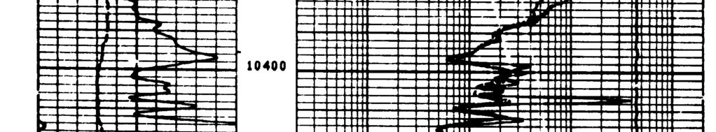
28 ALBIN FARMS 31X-31 Southeast Lateral TVD Gamma Ray Rate of Penetration Total Mud Gas TVD Lodgepole fm False Bakken Lower Lodgepole Ls Upper Bakken Shale Middle Bakken Dolomite TARGET ZONE Gamma Ray ROP 0 GR - API Units ft/hr ROP Total Gas Units Mud gas response versus rate of penetration and TVD gamma ray response The bottom hole assembly was sliding through the entire graphed interval; thus, no error introduced by intermittent rotating. Mud weight appears to have been held relatively constant. A small amount of trip gas has been edited out of the total gas curve below below 10,443 TVD.
29 WELL OVERVIEW PLOT Headington Oil, LP Albin Farms 34X-32 SwSe 32-T24N-R57W Richland Co. MT Northwest Lateral MWD TVD TG ROP X 200 GR X 10 TVD False Bakken Bakken Shale --Casing WT 9.6+ WT TG TG Pl ugged exhaust l ine CORE #1 WT 9.8 WT 9.8 BAKKEN SHALE TIGHT DOLOMITE TG WT 9.8 Removed Pason Gas TG WT WT 10.0 MIDDLE BAKKEN POROSITY TARGET WT GR X 10, TG, ROP X200, PG MEASURED DEPTH
30 PRIMARY KEYS TO SUCCESS OF THE MIDDLE BAKKEN PLAY HORIZONTAL DRILLING & COMPLETION OF THE WELL WITH FRACTURE STIMULATION WELLS CONTAIN 4,000 TO 23,000 OF LATERAL PER WELL TYPICAL HORIZONTAL FRACTURE STIMULATION ($350,000 to $650,000) PER LATERAL, in open hole or uncemented pre-perfed liner hole: Gelled water-sand frac in several stages Sand concentration from 1 to 4+ pounds of sand per gallon (20-40 mesh sand, to ~100#/ft of hole) w/ additives, surfactants Pumped at a rate of BPM, (In 5,000 lateral, Total of ~5,000 bbls gelled water and 400,000# sand)
31 ELM COULEE SUMMARY PRODUCTION DEFINED TO DATE IN < 6 YEARS SINCE DISCOVERY (thru Mar/06), CUMULATIVE OIL PRODUCTION ~ 32 MILLION BBLS AVERAGE MONTHLY OIL PRODUCTION RATE (Jan/06) ~1.6 MILLION BBLS (MAR/06) FROM ~350 WELLS FIELD DAILY PRODUCTION RATE ~53,000 BBLS/DAY (Per/Well ~ 152 BOPD) CURRENTLY ~20 RIGS DRILLING CONTINUOUSLY COVERS APPROXIMATELY 530 SQUARE MILES TO DATE ULTIMATE RECOVERY > 250 MILLION BARRELS OF OIL (at 500,000± BO/Sq Mi) + Est > 300 BCFG (Est ave GOR 1,200 over life) WHY DOES IT WORK SO WELL? ELM COULEE BAKKEN CONTAINS WELL-DEVELOPED, WIDESPREAD MATRIX POROSITY AND PERMEABILITY WITH COINCIDENTAL FRACTURE OVERPRINT HORIZONTAL DRILLING VERY EFFECTIVE IN IMPROVING DELIVERABILITY BY ACCESSING MORE RESERVOIR RESERVOIR RESPONDS EXTREMELY WELL TO LARGE GELLED WATER/SAND FRAC STIMULATIONS REGULATORY AGENCY OPENNESS TO LARGE SPACING UNITS HAS ALLOWED MORE EFFICIENT AND EFFECTIVE DEVELOPMENT
Elm Coulee Oil Field Richland County, Montana. Bakken Oil Well FRAC TREATMENT
 Elm Coulee Oil Field Richland County, Montana Bakken Oil Well FRAC TREATMENT LOCATION MAP ELM COULEE FIELD RICHLAND COUNTY, MONTANA SASKATCHEWAN MANITOBA WILLISTON BASIN Poplar Dome Nesson Ant Brockton-Froid
The Giant Continuous Oil Accumulation in the Bakken Petroleum System, Williston Basin
 The Giant Continuous Oil Accumulation in the Bakken Petroleum System, Williston Basin Stephen A. Sonnenberg Department of Geology and Geological Engineering Colorado School of Mines Williston Basin Conference
Improving Well Performance through Multi Variate Completion Analyses in the US Bakken Shale. C. Mark Pearson
 Improving Well Performance through Multi Variate Completion Analyses in the US Bakken Shale C. Mark Pearson Liberty Resources LLC Denver, CO Slide 2 An independent, private-equity backed E&P company with
Integrated 3D Geological Model of the Mississippian Devonian Bakken Formation, Elm Coulee, Williston Basin: Richland County, Montana
 Integrated 3D Geological Model of the Mississippian Devonian Bakken Formation, Elm Coulee, Williston Basin: Richland County, Montana Adrian Almanza Colorado School of Mines Outline Location Stratigraphy
Stephanie B. Gaswirth and Kristen R. Mara
 U.S. Geological Survey Assessment of Undiscovered Resources in the Bakken and Three Forks Formations, Williston Basin, North Dakota, Montana, and South Dakota, 2013 Stephanie B. Gaswirth and Kristen R.
Unconventional Oil Plays Opportunity vs Risk
 Unconventional Oil Plays Opportunity vs Risk EnerCom s London Oil & Gas Conference 4 June 14, 2012 Sofitel London Danny D. Simmons 1000 BOPD - What a great well! 10,000 1,000 BOPD 100 10 12/2009 1/2010
The North Dakota Bakken Play - Observations. Julie A. LeFever North Dakota Geological Survey
 The North Dakota Bakken Play - Observations Julie A. LeFever North Dakota Geological Survey The Basics Bakken Formation in North Dakota Upper & Lower Black Shale World Class Source Rock TOC s as high as
The Bakken. A Non-Shale Shale Play. August 2010
 The Bakken A Non-Shale Shale Play August 2010 ConocoPhillips Unconventional Resource Experience in North America CBM San Juan Drunkards Wash Uinta Powder River Horseshoe Canyon Manville Shale Barnett Haynesville
North Dakota Geological Survey
 Review of Hydrocarbon Production from the Stonewall and lower Interlake Formations: western North Dakota Williston Basin Timothy O. Nesheim North Dakota Geological Survey North Dakota Geological Survey
Horizontal Injectors & Producers at SACROC Clyde Findlay II & Jeremy Pitts
 1 Horizontal Injectors & Producers at SACROC Clyde Findlay II & Jeremy Pitts Presented at the CO 2 & ROZ Conference. Dec 6, 2018 SACROC 2 SACROC phih Map 1948 - discovered in Scurry County, Texas 52,000
Unconventional Shale Plays in MT
 Unconventional Shale Plays in MT A Look at the Geology & Development of the Bakken and Heath Formations Jay Gunderson Montana Bureau of Mines and Geology Why Shales? Traditional Source Rocks Mostly clays
AADE Mid Continent Chapter. Bakken Shale Resource Play. Revisited. January 14, 2009 Jim Thompson
 AADE Mid Continent Chapter Bakken Shale Resource Play Revisited January 14, 2009 Jim Thompson Marathon 2007 History One Year Ago Today Re-entered basin in May 2006 Hit the ground running with two conventional
HISTORY OF HARTZOG DRAW FIELD
 7 th ANNUAL WYOMING CO2 CONFERENCE HISTORY OF HARTZOG DRAW FIELD 11 JULY 2013 HARTZOG DRAW INTRODUCTION WELCOME Click to edit Master YOU ARE title HERE! style 3 TERRAIN Click to edit / SCENIC Master VIEW
Bakken and Three Forks Logging Acquisition for Reservoir Characterization and Completion Optimization
 Bakken and Three Forks Logging Acquisition for Reservoir Characterization and Completion Optimization Ernest Gomez (egomez@denver.oilfield.slb.com), Peter Hook, Peter S. Kaufman and Stephen D. Sturm Acknowledgements
Bakken/Torquay Development: A Manitoba Update. Dan Barchyn
 Bakken/Torquay Development: A Manitoba Update Dan Barchyn Outline History of Bakken/Torquay Development in Manitoba Examples of different play types: Daly Pools: Finding sweet spots in an area of ubiquitous
MIDDLE DEVONIAN PLAY MICHIGAN BASIN OF ONTARIO. Duncan Hamilton
 MIDDLE DEVONIAN PLAY MICHIGAN BASIN OF ONTARIO Duncan Hamilton 1 Middle Devonian Pools of the Michigan Basin 375+ Million Barrels Michigan 45+ million Barrels Ontario 2 Outline of Presentation History
Steve Cumella 1. Search and Discovery Article # (2009) Posted July 30, Abstract
 Posted July 30, Abstract") AV Geology of the Piceance Basin Mesaverde Gas Accumulation* Steve Cumella 1 Search and Discovery Article #110106 (2009) Posted July 30, 2009 *Adapted from oral presentation at AAPG Annual Convention,
AV Geology of the Piceance Basin Mesaverde Gas Accumulation* Steve Cumella 1 Search and Discovery Article #110106 (2009) Posted July 30, 2009 *Adapted from oral presentation at AAPG Annual Convention,
Source Rock Reservoir Characterization Using Geology, Geochemical and Drilling Data
 Source Rock Reservoir Characterization Using Geology, Geochemical and Drilling Data Robert Shelley PE, StrataGen Amir Mohammadnejad PhD, StrataGen Stanislav Sheludko, StrataGen 2007 Established Bakken
Horizontal San Andres Play
 Horizontal San Andres Play Russell K. Hall Presented at the CO 2 & ROZ Conference Dec 5, 2018 Midland, Texas CO 2 Recovery Conference Permian Basin Trends Horizontal San Andres Play PERMIAN BASIN TRENDS
RAILROAD COMMISSION OF TEXAS OIL WELL POTENTIAL TEST, COMPLETION OR RECOMPLETION REPORT, AND LOG
 RAILROAD COMMISSION OF TEXAS 1701 N. Congress P.O. Box 12967 Austin, Texas 78701-2967 Status: Form W-2 OIL WELL POTENTIAL TEST, COMPLETION OR RECOMPLETION REPORT, AND LOG Date: Tracking.: Approved 01/05/2016
Canadian Bakken IOR/CO 2 Pilot Projects
 Canadian Bakken IOR/CO 2 Pilot Projects Richard Baker, Leon De Villiers, Crystal Lok, Tim Stephenson Baker Hughes Presented at the 20 th Annual CO 2 Flooding Conference December 11-12, 2014 Midland, Texas
Wattenberg Field Area, A Near Miss & Lessons Learned After 35 Years of Development History. Stephen A. Sonnenberg Robert J. Weimer
 Wattenberg Field Area, A Near Miss & Lessons Learned After 35 Years of Development History Stephen A. Sonnenberg Robert J. Weimer Front Wattenberg Field DJ Basin WYOMING Pay PIERRE SHALE Typical Depth
Testing of the Strawn Sand, White Hat 20#3, Mustang Prospect, Permian Basin, Texas
 Date: 11 April 2019 ASX Code: WEL Directors John Kopcheff Non-Executive Chairman Neville Henry Managing Director Peter Allchurch Non-Executive Director Larry Liu Non-Executive Director Lloyd Flint Company
Paradoxes to Mississippian Production
 Goals Field Examples of Fracturing and Drainage by Kurt Rottmann Understand fracture patterns in the Mississippian Review older fracture identification logs Review fracture components to volumetric OOIP
region includes nine states and four provinces, covering over 1.4 million square miles. The PCOR Partnership
 Overview of Phase II PCOR Partnership MVA Activities IEAGHG Monitoring Network Meeting Natchez, MS May 6-8, 2010 Steven A. Smith, Energy & Environmental Research Center The Plains CO 2 Reduction (PCOR)
Saskatchewan Oil Hot Plays Melinda Yurkowski, P.Geo
 Saskatchewan Oil Hot Plays Melinda Yurkowski, P.Geo Saskatchewan Geological Survey Saskatchewan Ministry of Energy and Resources April 18, 212 www.er.gov.sk.ca ~ 7, km 2 of Phanerozoiccover Total volume
EVALUATION OF KEY FACTORS AFFECTING SUCCESSFUL OIL PRODUCTION IN THE BAKKEN FORMATION, NORTH DAKOTA. Technology Status Assessment.
 EVALUATION OF KEY FACTORS AFFECTING SUCCESSFUL OIL PRODUCTION IN THE BAKKEN FORMATION, NORTH DAKOTA Technology Status Assessment Prepared by: James A. Sorensen Senior Research Manager Energy & Environmental
Correlating Petrophysical Calculations from Density Logs to Production Trends in the Elm Coulee Field, Montana
 Montana Tech Library Digital Commons @ Montana Tech Graduate Theses & Non-Theses Student Scholarship Spring 2015 Correlating Petrophysical Calculations from Density Logs to Production Trends in the Elm
An outcrop analogue for the Williston Basin Bakken hybrid play, the Sappington Formation in southwest Montana:
 An outcrop analogue for the Williston Basin Bakken hybrid play, the Sappington Formation in southwest Montana: Facies, stratigraphic architecture, and controls on porosity distribution Michael Hofmann
StackFRAC HD system outperforms cased hole in vertical wells
 Case Study StackFRAC HD system outperforms cased hole in vertical wells UNITED STATES, PERMIAN BASIN STACKFRAC HD SYSTEM Background The Permian Basin consists of several stacked pay zones and is one of
Stratigraphy and Hydrocarbon Production from Pennsylvanian Age Granite Wash Reservoirs in the Western Anadarko Basin, Oklahoma and Texas
 Stratigraphy and Hydrocarbon Production from Pennsylvanian Age Granite Wash Reservoirs in the Western Anadarko Basin, Oklahoma and Texas John Mitchell, Managing Partner/Consulting Geologist Fall River
Lithological variation of Middle Bakken reservoirs in SE Saskatchewan: implications for optimizing multi-stage hydraulic fracturing
 Lithological variation of Middle Bakken reservoirs in SE Saskatchewan: implications for optimizing multi-stage hydraulic fracturing Hairuo Qing, Guoxiang Chi, Adam Sturiala Dept of Geology University of
Recap and Integrated Rock Mechanics and Natural Fracture Study on the Bakken Formation, Williston Basin Abstract Figure 1:
 Recap and Integrated Rock Mechanics and Natural Fracture Study on the Bakken Formation, Williston Basin Cosima Theloy, Department of Geology & Geological Engineering Abstract The late Devonian to early
Sequence Stratigraphy of the Upper Cretaceous Niobrara Formation, A Bench, Wattenberg Field, Denver Julesburg Basin, Colorado*
 Sequence Stratigraphy of the Upper Cretaceous Niobrara Formation, A Bench, Wattenberg Field, Denver Julesburg Basin, Colorado* Lisa E. Remington LaChance 1 and Mark C. Robinson 1 Search and Discovery Article
Update - Testing of the Strawn Sand, White Hat 20#3, Mustang Prospect, Permian Basin, Texas
 Date: 15 April 2019 ASX Code: WEL Directors John Kopcheff Non-Executive Chairman Neville Henry Managing Director Peter Allchurch Non-Executive Director Larry Liu Non-Executive Director Lloyd Flint Company
Bakken Project Phase I Southeastern Saskatchewan Phase II North Dakota
 Bakken Project Phase I Southeastern Saskatchewan Phase II North Dakota Geology, Hydrogeology and Reservoir Characterization Unconventional Oil? The Bakken Formation has fast become the hottest onshore
Horizontal Fracturing in Shale Plays. Matt McKeon
 Horizontal Fracturing in Shale Plays Matt McKeon Shortening the learning curve Historically: a trial-and-error process Data acquisition USA analog fields can speed up evaluation and development Quantify
Recap and Integrated Rock Mechanics and Natural Fracture Study in the Bakken Formation, Williston Basin
 Recap and Integrated Rock Mechanics and Natural Fracture Study in the Bakken Formation, Williston Basin EERC, 2011 Cosima Theloy PhD Candidate Department of Geology and Geological Engineering Colorado
The Oyster Bayou CO 2 Flood Case History. Alton Ahrens, Denbury Resources
 The Oyster Bayou CO 2 Flood Case History Alton Ahrens, Denbury Resources N Y S E : D N R w w w. d e n b u r y. c o m Table of Contents o Highlights of the CO2 Flood o Pre-CO 2 History o o o Location and
Introduction Geology
 Introduction The Wild Horse Anticline is located in the prolific Bighorn Basin of Wyoming about 5 miles northeast of the town of Basin. This structure demonstrates excellent fourway closure encompassing
For personal use only
 Date: 18 February 2019 ASX Code: WEL Directors John Kopcheff Non-Executive Chairman Neville Henry Managing Director Peter Allchurch Non-Executive Director James Hodges Non-Executive Director Larry Liu
Shale Development and Hydraulic Fracturing or Frac ing (Fracking) What is it?
 What is it?") P E T R O L E U M E N G I N E E R I N G D E P A R T M E N T Shale Development and Hydraulic Fracturing or Frac ing (Fracking) What is it? Dr. Will Fleckenstein, PE Colorado School of Mines 1 Who is involved
P E T R O L E U M E N G I N E E R I N G D E P A R T M E N T Shale Development and Hydraulic Fracturing or Frac ing (Fracking) What is it? Dr. Will Fleckenstein, PE Colorado School of Mines 1 Who is involved
DEVEX Moving in the Right Direction; Realising Upside Potential in a Mature Field Using Real Time 3D Geo-Steering Technology
 DEVEX 2010 Moving in the Right Direction; Realising Upside Potential in a Mature Field Using Real Time 3D Geo-Steering Technology Authors: Lisa Chisholm, Chevron Upstream Europe David Holbrough, Baker
PETROPHYSICAL EVALUATION CORE COPYRIGHT. Saturation Models in Shaly Sands. By the end of this lesson, you will be able to:
 LEARNING OBJECTIVES PETROPHYSICAL EVALUATION CORE Saturation Models in Shaly Sands By the end of this lesson, you will be able to: Explain what a shale is and how to distinguish between a shaly sand and
LOUISIANA ENERGY CONFERENCE Tuscaloosa Marine Shale An Emerging Oil Play June 27, 2012
 LOUISIANA ENERGY CONFERENCE Tuscaloosa Marine Shale An Emerging Oil Play June 27, 2012 1 TUSCALOOSA MARINE SHALE Emerging Shale Oil Play Emerging shale oil play 132,000 net acres leased Net cost $30 million
Barnett Shale-Woodford Shale play of the Delaware basin is it another giant shale gas field in Texas?
 Barnett Shale-Woodford Shale play of the Delaware basin is it another giant shale gas field in Texas? Bob Cluff The Discovery Group, Inc Denver, Colorado, USA bobcluff@discovery-group.com Delaware basin
BACKGROUND GEOLOGY. Hoaglund 1. Wichita Orogeny to the south (10k 15k uplift) Rapid erosion and deposition of uplifted granitic basement rock ~18,000
 Rapid erosion and deposition of uplifted granitic basement rock ~18,000") POST APPRAISAL OF THE MISSOURIAN HOGSHOOTER HYDROCARBON SYSTEM: IMPLICATIONS FOR FUTURE EXPLOITATION IN THE ANADARKO BASIN STEVE HOAGLUND (GEOLOGIST CHESAPEAKE ENERGY) BACKGROUND GEOLOGY Wichita Orogeny
POST APPRAISAL OF THE MISSOURIAN HOGSHOOTER HYDROCARBON SYSTEM: IMPLICATIONS FOR FUTURE EXPLOITATION IN THE ANADARKO BASIN STEVE HOAGLUND (GEOLOGIST CHESAPEAKE ENERGY) BACKGROUND GEOLOGY Wichita Orogeny
COPYRIGHT. Optimization During the Reservoir Life Cycle. Case Study: San Andres Reservoirs Permian Basin, USA
 Optimization During the Reservoir Life Cycle Case Study: San Andres Reservoirs Permian Basin, USA San Andres Reservoirs in the Permian Basin Two examples of life cycle reservoir management from fields
U.S. Unconventional Play Round-up
 Drilling Info Open To Explore U.S. Shale Plays U.S. Unconventional Play Round-up Allen Gilmer, CEO February 28, 2011 35,000 new wells. RIG COUNT Barnett Rig = 300 Neuquen = 34 US Unconventional = 1000
The Capitan Aquifer - Ellenburger Production Wells Geothermal Engine Source?
 GEOTHERMAL ENERGY UTILIZATION ASSOCIATED WITH OIL & GAS DEVELOPMENT June 17-18, 2008 Southern Methodist University Dallas, Texas The Capitan Aquifer - Ellenburger Production Wells Geothermal Engine Source?
Lower Skinner Valley Fill Sandstones: Attractive Exploration Targets on the Northeast Oklahoma Platform*
 Lower Skinner Valley Fill Sandstones: Attractive Exploration Targets on the Northeast Oklahoma Platform* By Jim Puckette 1 Search and Discovery Article #10050 (2003) *Adapted from presentation to Tulsa
Geologic influence on variations in oil and gas production from the Cardium Formation, Ferrier Oilfield, west-central Alberta, Canada
 Geologic influence on variations in oil and gas production from the Cardium Formation, Ferrier Oilfield, west-central Alberta, Canada Marco Venieri and Per Kent Pedersen Department of Geoscience, University
Fracking for Tight Oil and Shale Gas in the U.S.
 Fracking for Tight Oil and Shale Gas in the U.S. Terminology 1. Crude Oil: Liquid petroleum extracted from the Earth (barrels, bbl) 2. Natural Gas: Mixture of hydrocarbon and non-hydrocarbon gases extracted
Downloaded 12/03/13 to Redistribution subject to SEG license or copyright; see Terms of Use at
 URTeC 1581459 Upper and Lower Bakken Shale Production Contribution to the Middle Bakken Reservoir Sanyog Kumar, Todd Hoffman, Manika Prasad, Colorado School of Mines Copyright 2013, Unconventional Resources
Exploration, Drilling & Production
 Nontechnical Guide to PETMOLEUM Geology, Exploration, Drilling & Production Third Edition Norman J. Hyne, Ph.D. Contents Preface *i Introduction 1 The Nature of Gas and Oil 1 Petroleum 1 The Chemistry
Atlantic Rim Coalbed Methane Play: The Newest SuccessfulCBM Play in the Rockies
 Atlantic Rim Coalbed Methane Play: The Newest SuccessfulCBM Play in the Rockies Robert A. Lamarre Lamarre Geological, Denver, Colorado Stephen K. Ruhl Anadarko Petroleum Corporation, The Woodlands, Texas
Reservoir Characterization for the Application of ASP Flood Technology in the Bridgeport Sandstone in Lawrence Field, Illinois*
 Reservoir Characterization for the Application of ASP Flood Technology in the Bridgeport Sandstone in Lawrence Field, Illinois* Nathan D. Webb 1, Vineeth Madhavan 1, John P. Grube 1, Curt S. Blakley 1,
Alaska Oil Discoveries
 Identifying new prospects in Alaska's North Slope trends. Chris Williams, MS., PG. Geoscience Advisor Stratigraphic Column Era M.Y.A. Albian ~113 Formation Oil and Gas Producing Areas Kuvlum, Hammerhead.
Burket/Geneseo Shale Appalachia s little brother to the Marcellus & Utica
 Burket/Geneseo Shale Appalachia s little brother to the Marcellus & Utica Gregory Wrightstone Presented at: WrightstoneEnergy.com October 8, 2015 Pittsburgh Association of Petroleum Geologists Pittsburgh,
4. Carboniferous Zone Play Results
 C H A P T E R F O U R 4. Carboniferous Zone Play Results 4. Geological Overview In the WCSB, there were two main depositional areas during Carboniferous time the Peace River Embayment in northwestern Alberta,
Keys to Successful Multi-Fractured Horizontal Wells In Tight and Unconventional Reservoirs
 Keys to Successful Multi-Fractured Horizontal Wells In Tight and Unconventional Reservoirs Presented by: Larry K. Britt NSI Fracturing & Britt Rock Mechanics Laboratory Key Questions for Horizontal Success
A Case Study in Integrating Core into an Oil Field Development
 A Case Study in Integrating Core into an Oil Field Development Mike Millar With acknowledgements to: Ichron Ltd; Rob Newbould, James Gifford and other colleagues at Petro-Canada. Aberdeen Formation Evaluation
Reservoir Management Background OOIP, OGIP Determination and Production Forecast Tool Kit Recovery Factor ( R.F.) Tool Kit
 Tool Kit") Reservoir Management Background 1. OOIP, OGIP Determination and Production Forecast Tool Kit A. Volumetrics Drainage radius assumption. B. Material Balance Inaccurate when recovery factor ( R.F.) < 5 to
Reservoir Management Background 1. OOIP, OGIP Determination and Production Forecast Tool Kit A. Volumetrics Drainage radius assumption. B. Material Balance Inaccurate when recovery factor ( R.F.) < 5 to
Geomechanical Controls on Hydraulic Fracturing in the Bakken Fm, SK
 Geomechanical Controls on Hydraulic Fracturing in the Bakken Fm, SK Chris Hawkes University of Saskatchewan Tight Oil Optimization Conference, Calgary AB, March 12, 2015 Outline Overview of Geomechanical
Geology of the Gull Lake North ASP Flood, Upper Shaunavon Formation, Southwest Saskatchewan
 Geology of the Gull Lake North ASP Flood, Upper Shaunavon Formation, Southwest Saskatchewan By Sid Leggett, Husky Energy (sid.leggett@huskyenergy.com) Acknowledgements Husky Energy Members of the Gull
THE NEXT WAVE IN THE ILLINOIS BASIN
 THE NEXT WAVE IN THE ILLINOIS BASIN Themes Low Risk High Margins Opportunity through Joint Venture Ron Prefontaine ron@strata-x.com www.strata-x.com TSX.V: SXE ASX: SXA 2 Key Management with operations
The Evolution of Drilling Techniques at the Camden Gas Project. Chris Holmes and Jon Black AGL 27 th June 2007
 The Evolution of Drilling Techniques at the Camden Gas Project Chris Holmes and Jon Black AGL 27 th June 2007 1 Camden Gas Project Status AGL acquired operatorship from Sydney Gas February 2006 106 production
Subsurface Maps. K. W. Weissenburger. Isopach. Isochore. Conoco, Inc. Ponca City, Oklahoma, U.S.A.
 Subsurface Maps K. W. Weissenburger Conoco, Inc. Ponca City, Oklahoma, U.S.A. INTRODUCTION Reservoir properties are mapped to promote optimal field development. Subsurface maps dictate well placement and
Dakota Sandstone. of the Moxa Arch and Surrounding Green River Basin
 Dakota Sandstone of the Moxa Arch and Surrounding Green River Basin Dakota Sandstones of the Green River Basin Overview The Dakota sandstones of the Moxa Arch and surrounding Green River Basin remain attractive
Characterization of Seismically-Imaged Pennsylvanian Ooid Shoal Geometries and Comparison with Modern
 Characterization of Seismically-Imaged Pennsylvanian Ooid Shoal Geometries and Comparison with Modern W. Lynn Watney, Evan K. Franseen, Alan P. Byrnes, Rick Miller, and Abdelmoneam E. Raef Kansas Geological
A supplement to. The Playbook
 A supplement to The Playbook Bakken/Three Forks: The Playbook A supplement to Oil and Gas Investor, E&P, and PipeLine and Gas Technology HART ENERGY PUBLISHING 1616 S. Voss, Suite 1000 Houston, Texas
Oil Company Company et al Foothills W6
 800, 555 4 th Avenue SW, Calgary, AB T2P 3E7 Off: 403-234-7625, www.wellsitegeologists.com Cell: 660-9883, Dennis@WellsiteGeologists.com Geological Report for Oil Company Company et al Foothills 06-06-060-06W6
SCOOP HORIZONTAL WOODFORD PROJECT
 SCOOP HORIZONTAL WOODFORD PROJECT Far West Development (FWD) Proposes a non operated Horizontal Woodford Shale well (10,000 lateral) in the South Central Oklahoma Oil Province SCOOP. Newfield Exploration
Characterization and Modeling of Naturally Fractured Tensleep Reservoirs
 Characterization and Modeling of Naturally Fractured Tensleep Reservoirs Shaochang Wo, Peigui Yin, Scott Cooper, John Lorenz J A N U A R Y 1 8, 2 0 1 1, D E N V E R A Brief Overview of the Tensleep Reservoirs
Petrophysical Data and Open Hole Logging Operations Basics COPYRIGHT. Introduction to Petrophysical Data and Open Hole Logging Operations Basics
 Learning Objectives Petrophysical Data and Open Hole Logging Operations Basics Introduction to Petrophysical Data and Open Hole Logging Operations Basics By the end of this lesson, you will be able to:
Development of Kern County s Rose Oil Field*
 Development of Kern County s Rose Oil Field* Dan Wynne 1 and Mel Patel 1 Search and Discovery Article #2316 (215)** Posted July 2, 215 *Adapted from oral presentation given at Pacific Section AAPG, SEG
MicroScope. Resistivity- and imagingwhile-drilling
 MicroScope Resistivity- and imagingwhile-drilling service MicroScope Magnify your reservoir Multidepth laterolog resistivity Multidepth borehole images Mud resistivity Azimuthal gamma ray Bit resistivity
OKLAHOMA CORPORATION COMMISSION OIL & GAS CONSERVATION DIVISION P.O. BOX OKLAHOMA CITY, OK (Rule 165:10-3-1) PERMIT TO DRILL
 PERMIT TO DRILL") API NUMBER: 039 Horizontal Hole 22504 Oil & Gas OKLAHOMA CORPORATION COMMISSION OIL & GAS CONSERVATION DIVISION P.O. BOX 52000 OKLAHOMA CITY, OK 73152-2000 (Rule 165:10-3-1) Approval Date: 06/05/2017 Expiration
API NUMBER: 039 Horizontal Hole 22504 Oil & Gas OKLAHOMA CORPORATION COMMISSION OIL & GAS CONSERVATION DIVISION P.O. BOX 52000 OKLAHOMA CITY, OK 73152-2000 (Rule 165:10-3-1) Approval Date: 06/05/2017 Expiration
David J. Bardin 30 November Subject: How Will EIA Capture and Report Information as to Bakken Crude Oil?
 Honorable Guy F. Caruso, Administrator Energy Information Administration U.S. Department of Energy By e-mail David J. Bardin DavidBardin@aol.com 30 November 2005 Subject: How Will EIA Capture and Report
Slocombe Rood #1 19. Unger Field, Marion County Enhancing Oil Recovery from Mature Reservoirs Using a Lateral with Gamma Ray
 Slocombe Rood #1 19 Results from a Hunton ntonhorizontal ontal Well Unger Field, Marion County Enhancing Oil Recovery from Mature Reservoirs Using a Lateral with Gamma Ray Sensor, Drillpipe i Conveyed
Central North Dakota Shallow Gas Potential A Historical Perspective
 Central Shallow Gas Potential A Historical Perspective David W. Fischer Fischer Oil and Gas, Inc. Fred J. Anderson Department CURRENT ND ACTIVITIES ONLINE BIBLIOGRAPHY OF SHALLOW GAS REFERENCES ONLINE
ALBERTA S CARDIUM OIL AND THE EVOLUTION OF CUTOFFS AND EVALUATION PROCEDURES IN RESPONSE TO HORIZONTAL DRILLING
 ALBERTA S CARDIUM OIL AND THE EVOLUTION OF CUTOFFS AND EVALUATION PROCEDURES IN RESPONSE TO HORIZONTAL DRILLING Alberta s Cardium Oil and the Evolution of Cutoffs and Evaluation Procedures in Miranda Stoffman,
Investor Presentation. January
 2011 Investor Presentation January Summary Exchange / Ticker: NYSE AMEX / TPLM Recent Stock Price: $6.61 per share (1/4/11) Pro Forma Shares Outstanding: Current Bakken Acreage Position Current Well Activity
Ministry of Oil and Minerals Petroleum Exploration & Production Authority BLOCK 85 (Al Uqlah North)
") Ministry of Oil and Minerals Petroleum Exploration & Production Authority BLOCK 85 (Al Uqlah North) The Al Uqlah North Block (85) occupies an area of 597 km 2 in the Sabatayn Basin in the province of Shabwah
Ministry of Oil and Minerals Petroleum Exploration & Production Authority BLOCK 85 (Al Uqlah North) The Al Uqlah North Block (85) occupies an area of 597 km 2 in the Sabatayn Basin in the province of Shabwah
Radial- Basis Function Network Applied in Mineral Composition Analysis
 Radial- Basis Function Network Applied in Mineral Composition Analysis Shaochang Wo & Peigui Yin January 13, 2010, Denver Mineral composition in the Minnelusa Formation can be calculated from the sonic,
Economic Development of Pennsylvanian Age Granite Wash Reservoirs with Horizontal Wells in the Anadarko Basin*
 Economic Development of Pennsylvanian Age Granite Wash Reservoirs with Wells in the Anadarko Basin* John Mitchell 1 Search and Discovery Article #10734 (2015) Posted March 30, 2015 *Adapted from presentation
YEARLY TECHNICAL PROGRESS REPORT (8 th Year )
") PRRC 03-18 YEARLY TECHNICAL PROGRESS REPORT (8 th Year 2002-2003) ADVANCED OIL RECOVERY TECHNOLOGIES FOR IMPROVED RECOVERY FROM SLOPE BASIN CLASTIC RESERVOIRS, NASH DRAW BRUSHY CANYON POOL, EDDY COUNTY,
PRRC 03-18 YEARLY TECHNICAL PROGRESS REPORT (8 th Year 2002-2003) ADVANCED OIL RECOVERY TECHNOLOGIES FOR IMPROVED RECOVERY FROM SLOPE BASIN CLASTIC RESERVOIRS, NASH DRAW BRUSHY CANYON POOL, EDDY COUNTY,
For personal use only
 Vail Project Primer Contact: Tim Hoops Managing Director tim.hoops@strata-x.com www.strata-x.com Why is Strata-X drilling in Illinois? Illinois is a Proven and Mature Oil Provence Production dates back
DEVONIAN OIL AND GAS PLAYS OF THE MICHIGAN BASIN
 DEVONIAN OIL AND GAS PLAYS OF THE MICHIGAN BASIN William B. Harrison, III Michigan Geological Repository for Research and Education (MGRRE) Western Michigan University-Michigan Geological Survey 1 Devonian
Importance of regional geological and petrophysical analysis: Bakken/Three Forks formations of the Williston basin North Dakota and Montana
 Importance of regional geological and petrophysical analysis: Bakken/Three Forks formations of the Williston basin North Dakota and Montana Presenter: Stefani Brakenhoff The Discovery Group Team: Bob Cluff,
GeoCanada 2010 Working with the Earth
 Lithofacies Identification and the Implications for SAGD Well Planning in the McMurray Formation, Christina Lake Area, Alberta Travis Shackleton*, Robert Gardner, Sung Youn, Grace Eng and Lori Barth Cenovus
NORTHEAST EL HAMD BLOCK
 NORTHEAST EL HAMD BLOCK NORTHEAST EL HAMD BLOCK LOCATION : The block is locating in the eastern side of the central part of the Gulf of Suez basin west and south of Belayim fields. NORTHEAST EL HAMD BLOCK
Overview - Minnelusa
 Overview - Minnelusa Minnelusa I Gillette, Wyo. Nick Jones, PG Sr. Geologist EORI May 6-7, 213 INFORMATION- RESOURCE Topics Part I Key Resources History of Development Pace of Discovery Minnelusa Today
SPE MS Mississippi Canyon Gulf of Mexico Frac Pack Case Histories and the Importance of Proppant Tracing and Gravel Pack Logging
 SPE-181658-MS Mississippi Canyon Gulf of Mexico Frac Pack Case Histories and the Importance of Proppant Tracing and Gravel Pack Logging Jack Sanford, SPE Agenda Introduction Case History Summary Location
OKLAHOMA CORPORATION COMMISSION OIL & GAS CONSERVATION DIVISION P.O. BOX OKLAHOMA CITY, OK (Rule 165:10-3-1) PERMIT TO DRILL
 PERMIT TO DRILL") API NUMBER: 039 Horizontal Hole 22513 Oil & Gas OKLAHOMA CORPORATION COMMISSION OIL & GAS CONSERVATION DIVISION P.O. BOX 52000 OKLAHOMA CITY, OK 73152-2000 (Rule 165:10-3-1) Approval Date: 08/11/2017 Expiration
API NUMBER: 039 Horizontal Hole 22513 Oil & Gas OKLAHOMA CORPORATION COMMISSION OIL & GAS CONSERVATION DIVISION P.O. BOX 52000 OKLAHOMA CITY, OK 73152-2000 (Rule 165:10-3-1) Approval Date: 08/11/2017 Expiration
Considerations for Infill Well Development in Low Permeability Reservoirs
 Considerations for Infill Well Development in Low Permeability Reservoirs George Waters Technical Manager Unconventional Completions September 9, 2014 Topics Continuous Improvement in Field Development
WEJCO. Exploration & Production. Eagle s Talon Prospect. The Eagle s Talon Prospect is located in south eastern Karnes County,
 WEJCO Exploration & Production Eagle s Talon Prospect The Eagle s Talon Prospect is located in south eastern Karnes County, Texas, within the new and highly prolific unconventional Eagle Ford Shale trend
Lithologic and Petrophysical Characterization of the Upper Silurian Interlake Group, Nesson Anticline Area, North Dakota and Eastern Montana
 AAPG 2018 ACE101:Bridging Fundamentals and Innovation Theme 2: Carbonates of Western North America Salt Lake City, UT May 20-23, 2018 Lithologic and Petrophysical Characterization of the Upper Silurian
AGENDA. Criteria for Fluid Selection Controlling Cost Continuously Improving Performance
 AGENDA Criteria for Fluid Selection Controlling Cost Continuously Improving Performance WELLBORE STABILITY & HOLE ENLARGEMENT DRILLING FLUIDS COMPARISON Non Aqueous Fluids (diesel, synthetic, etc.) Brine
Identification of Future Oil Potential From Upper Devonian Venango Sandstones in the Central Appalachians
 Identification of Future Oil Potential From Upper Devonian Venango Sandstones in the Central Appalachians Eric Ober, Craig Eckert January 23, 2014 Overview History of Oil Drilling In West Virginia Geology