EUROGEOSURVEYS Geotourism in Africa proposition of case studies
|
|
|
- Florence Emerald Kennedy
- 5 years ago
- Views:
Transcription

 Marek Graniczny")
1 4 0 Years Listening to the Beat of the Earth EUROGEOSURVEYS Geotourism in Africa proposition of case studies Izabela Ploch (PIG NRI) Marek Graniczny (PIG NRI)
2 Geotourism in Africa. Geotourism integrates the preservation of geological heritage into regional economic development and management strategies. Some countries in Africa have started to develop schemes for recognizing important geological and geomorphological sites or landscapes within their borders. A preliminary inventory of potential geosites has been compiled for a few countries only: Ethiopia, Kenya, Namibia, South Africa, Tanzania and Uganda. It covers about 10% in the scale of the whole African continent (according to T. Schlüter. 2006).
3 Geosites database for S. Africa (SADC region) Project proposal in cooperation with: SA, Council for Geoscience Dani Bernardo Online database of geological sites in Africa was initially developed by the Council for Geoscience (CGS) in South Africa. A total of 121 described geosites are already available via the Internet. These sites are located mainly in South Africa, as well as in Zimbabwe and Lesotho.
4 Geosites database for S. Africa The online database will contain location and descriptive and contact information about geologically attractive and interesting sites in Africa. The database will identify these sites to potential visitors and is aimed at education, as well as attracting tourists and potential investors in geotourism to these sites. Preservation of the sites can be also beneficial and make possible protection of these sites in landuse planning of future expansion, mining and other investments.

5 Geological Society of South Africa is promoting establishment of Africa s first Geopark at the Tswaing Meteorite Impact Crater

6 One of the geosites from initial data base - Table Mt. Cape Town
7 Development of Geosites Database for Tanzania Project proposal in cooperation with: Tanzania, SEAMIC Ketema Tadesse Tanzania is known as a favourite tourist destination for its natural and historical heritage. The highest peak of the continent, Kilimanjaro Mountain and the Serengeti Plane known to have the large collection of the major wild life varieties in the continent are the main attractions of the tourism industry. Application to the Polish Ministry of Foreign Affairs for financial support.
8 Development of Geosites Database for Tanzania During the workshop on Geosites and Geoconservation in East Africa, held in Nairobi in February 1999 the following geosites were proposed and recommended to Tanzania: Tendaguru Hill, Ngorongoro Crater, Oldoinyo Lengai Volcano, Laetoli Fossil Site, Olduvai Gorge, Mbozi Iron Meteorite.

9 Oldoinyo Lengai the world's only active volcano erupting carbonatite lava in northern Tanzania. Activities like volcanism, seismicity, weathering and erosion can be easily studied here. The volcano is sacred to the Maasai of East Africa and they worship it as their god.


10 Ngorongoro Crater spectacular site, a home of thousands of wild animals is underlain by Pliocene Olivine basalts and pyroclastics. The crater is famous for varieties of wildlife, 'magic' moving sand, and spectacular geomorphology. Ngorongoro Crater is nevertheless the largest, inactive, unbroken and unflooded caldera in the world.

11 Kilimanjaro the snow capped mountain, is the highest point in Africa. It is cut across and experiences high temperatures of equatorial climate. The mountain is a source of many springs, which are tributaries for most of the big rivers in Tanzania.

12 Geo-tourism in Central Copperbelt of Zambia and Congo DR Project proposal in cooperation with: Zambia, UNZA Prof. Imasiku Nyambe Congo DR, University of Lubumbashi Prof. François Lubala Toto Ruananza The top attraction Victoria Falls World Heritage Natural Monument Site was visited by about 100,000 tourists in Apart from the Victoria Falls, the management of other geological sites is limited and therefore does not contribute meaningfully to the tourism industry in Zambia.


13 Victoria Falls Victoria Falls world heritage natural monument site
14 Geo-tourism in Central Copperbelt of Zambia and Congo DR The project proposal is focused on documenting the potential geoparks which could be established in the territory of Zambia and Congo DR. Examples of such prospective areas include abandoned open pit such as: Chambeshi, Mindola or Mbwana - Mkumbwa in the Copperbelt.

15 Chambeshi open pit: a spectacular geological site
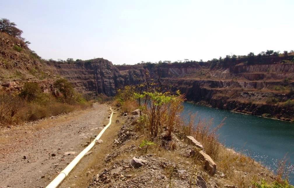
16 Mbwana-Mkumbwa open pit

17 THANK YOU FOR YOUR ATTENTION
Geodiversity, Geoheritage & Geoconservation
 Geodiversity, Geoheritage & Geoconservation Geodiversity what is its place within nature diversity? Geodiversity is the variety of nature elements, such as minerals, rocks, fossils, landforms and their
THE ROLE OF SEAMIC IN SUSTAINABLE MINERAL RESOURCES DEVELOPMENT IN AFRICA
 THE ROLE OF SEAMIC IN SUSTAINABLE MINERAL RESOURCES DEVELOPMENT IN AFRICA Ketema Tadesse Director General-SEAMIC Dar es Salaam, Tanzania August 11, 2009 SEAMIC BACKGROUND SEAMIC was established in 1977
Geopark Karavanke/Karawanken. Geo adventures in the cross- border geopark between Slovenia and Austria
 Geopark Karavanke/Karawanken Geo adventures in the cross- border geopark between Slovenia and Austria Msc. Suzana Fajmut Štrucl, Podzemlje Pece d.o.o. Msc. Mojca Bedjanič, Institute of the Republic of
GLOBAL NETWORK OF NATIONAL GEOPARKS. Patrick J Mc Keever
 Patrick J Mc Keever A GEOPARK is an area with. geological heritage of international significance but also with. a sustainable development strategy or plan involving local communities. IS A GEOPARK JUST
Making a Mental Map of the Region
 Africa Preview Making a Mental Map of the Region Draw an outline map of Africa on the next page or on a separate sheet of paper. Add a compass rose to your map, showing where north, south, east, and west
UNESCO Earth Science Education Initiative in Africa Initial Activities
 UNESCO Earth Science Education Initiative in Africa Initial Activities S. Felix Toteu 1 and Sarah Gaines 2 1 UNESCO Nairobi Office, Kenya 2 UNESCO Headquarters, Paris In Arusha, Tanzania on 8 May 2008
UNESCO s Earth Science. Education Initiative in Africa. United Nations Educational, Scientific and Cultural Organization
 UNESCO s Earth Science Education Initiative in Africa United Nations Educational, Scientific and Cultural Organization Few milestones First International Conference on African and Arabian Geoparks 2011,
Pioneering Geothermal Development in Tanzania Geothermal Exploration Drilling Activities
 Pioneering Geothermal Development in Tanzania Geothermal Exploration Drilling Activities GGDP Round table, 19.11.2013, The Hague Dr. Horst Kreuter, Director, Geothermal Power Tanzania Ltd Geothermal in
Role of Geotourism in Australia s Nature Based Tourism Strategy GlobalEco Angus M Robinson Geotourism Forum, Ecotourism Australia
 Role of Geotourism in Australia s Nature Based Tourism Strategy 2025 - GlobalEco 2016 Angus M Robinson Geotourism Forum, Ecotourism Australia Today s Agenda Nature Based Tourism Strategy 2025 Natural &
Botswana National Spatial Plan Botsreal Property Forum- 30 May, 2018
 Botswana National Spatial Plan 2036 Botsreal Property Forum- 30 May, 2018 What is the National Spatial Plan? A framework and process for planning that is: National (to guide national development policies,
Geotourism s Contribution to Protected Areas
 Geotourism s Contribution to Protected Areas Professor Ross Dowling Edith Cowan University, Australia GlobalECO 2014 Ecotourism in Protected Areas Forum 12 November 2014 Sydney Olympic Park, Sydney Australia
Contents Research Objects, Tasks and Historical Development of Tourism Earth-science Role of Tourism Earth-science in Tourism Development
 Contents 1 Research Objects, Tasks and Historical Development of Tourism Earth-science.... 1 1.1 Research Objects of Tourism Earth-science.... 1 1.1.1 Definition of Tourism Earth-science... 1 1.1.2 Definition
Twenty-four models of Geotourism
 Twenty-four models of Geotourism Tao Xu Zhenyang Wu Anze Chen E-mail: 378260643@qq.com; TEL:010-18610562209 Tao Xu, Ph. D., Director of Institute of geotourism, School of Humanities and Economic Management,
GeoHeritage Task Group
 IUGS / GTG Report 2014 p. 1 GeoHeritage Task Group http://geoheritage-iugs.mnhn.fr Annual Report 2015 Plan of action for 2016 TITLE OF CONSTITUENT BODY IUGS Geoheritage task group. This GTG was created
East Penn School District Curriculum and Instruction
 East Penn School District Curriculum and Instruction Curriculum for: Geology of National Parks Course(s): Geology of the National Parks Grades: 10-12 Department: Science Length of Period (average minutes):
ECONOMIC IMPACTS OF GEOTOURISM AND GEOPARKS IN CHINA
 ECONOMIC IMPACTS OF GEOTOURISM AND GEOPARKS IN CHINA Global Eco Asia-Pacific Conference 2017, Adelaide 27-29 November, 2017 Dr Young Ng MH Geotourism Standing Committee, Geological Society of Australia
GEOTOURISM IN LANGKAWI UNESCO GLOBAL GEOPARK
 LANGKAWI TOURISM SYMPOSIUM 2016 GEOTOURISM IN LANGKAWI UNESCO GLOBAL GEOPARK Prof. Emeritus Dato Dr. Ibrahim Komoo Council, UNESCO Global Geoparks Vice President, Asia Pacific Geoparks Network Advisor,
Application for Geotourism Charter
 Application for Geotourism Charter Thank you for the interest in geotourism as a long-term strategy to foster wisely managed tourism and enlightened destination stewardship. National Geographic s Center
Module 10: Resources and Virginia Geology Topic 4 Content: Virginia Geology Notes
 Virginia is composed of a very diverse landscape that extends from the beaches and barrier islands all of the way to the highly elevated Appalachian Plateau. Geologists have discovered ancient shallow
Geotourism: some examples from around the world and setting an agenda for the future
 Geotourism: some examples from around the world and setting an agenda for the future Resolving the definition Some examples of geotourism: Kalbarri (self-guided geotrail) Hyden (self-guided geotrail) Undara
Ol Doinyo Lengai. Tanzania, Eastern Africa S, E; summit elev. 2,962 m. All times are local (= UTC + 3 hours)
") Ol Doinyo Lengai Tanzania, Eastern Africa 2.764 S, 35.914 E; summit elev. 2,962 m All times are local (= UTC + 3 hours) Still active in 2012-2013; J.B. Dawson obituary We recently noted that Frederick
Ol Doinyo Lengai Tanzania, Eastern Africa 2.764 S, 35.914 E; summit elev. 2,962 m All times are local (= UTC + 3 hours) Still active in 2012-2013; J.B. Dawson obituary We recently noted that Frederick
5. What is latitude and longitude? 6. What do we mean by the UK? 2 B: Africa 1. To identify the physical features of Africa
 Geography Year 7 Year 7 Coordinator Mr.LLoyd Topics of Study This Year: Students study a broad range of introductory units that cover key skills and themes that will be developed throughout KS3. Students
Local Development Pilot Project: Island of Cres. Ranka Saračević Würth, Ministry of Culture, Republic of Croatia
 Local Development Pilot Project: Island of Cres Ranka Saračević Würth, Ministry of Culture, Republic of Croatia BACKGROUND, RATIFICATION OF THE FARO CONVENTION BY REPUBLIC OF CROATIA The Framework Convention
Geotourism (Book review) Author. Published. Journal Title DOI. Copyright Statement. Downloaded from. Griffith Research Online.
 Author. Published. Journal Title DOI. Copyright Statement. Downloaded from. Griffith Research Online.") Geotourism (Book review) Author Buckley, Ralf Published 2006 Journal Title Annals of Tourism Research DOI https://doi.org/10.1016/j.annals.2005.12.004 Copyright Statement 2006 Elsevier. This is the author-manuscript
Geotourism (Book review) Author Buckley, Ralf Published 2006 Journal Title Annals of Tourism Research DOI https://doi.org/10.1016/j.annals.2005.12.004 Copyright Statement 2006 Elsevier. This is the author-manuscript
IBI CORPORATION. GOLD and OTHER MINERAL EXPLORATION IN UGANDA
 IBI CORPORATION GOLD and OTHER MINERAL EXPLORATION IN UGANDA In the last two years, gold has taken on a renewed glitter, with a significant run-up in price. This aspect has obviously created the current
Geoparks A powerful new development vehicle for regional Australia
 Geoparks A powerful new development vehicle for regional Australia Professor Ross Dowling OAM Chair, Great South West Edge National Landscape Spotlight 7 Regional Tourism and Geotourism Thursday 27 October
Marketing Australia s Scenic Areas SEGRA, 26 October Angus M Robinson Chair, GSA Geotourism Standing Committee
 Marketing Australia s Scenic Areas SEGRA, 26 October 2017 Flinders Ranges National Landscape Angus M Robinson Chair, GSA Geotourism Standing Committee Today s Agenda Chinese tourism to Australia Challenges
IAVCEI. Commission on Volcano Geoheritage and Protected Volcanic Landscapes
 IAVCEI Commission on Volcano Geoheritage and Protected Volcanic Landscapes Joan Marti 1; Károly Németh 2, Tom Casadewall 3; Mohammed Rashad Moufti 4, 1 Institute of Earth Sciences "Jaume Almera, CSIC,
Risk Management Strategy
 Risk Management Strategy 1 Purpose To protect the component parts of the World Heritage property as well as the lives and the property of visitors and residents from disasters such as volcanic eruptions,
Living in the shadow of Italy's volcanoes
 Living in the shadow of Italy's volcanoes Where are the Aeolian Islands? The Aeolian Islands are a group of eight volcanic islands that lie off the northern coast of Sicily (Figure 1). Whilst they are
GeoHeritage Task Group
 IUGS / GTG Report 2013 p. 1 GeoHeritage Task Group http://geoheritage-iugs.mnhn.fr Annual Report 2013 Plan of action for 2014 TITLE OF CONSTITUENT BODY IUGS GeoHeritage Task Group. This GTG was created
Rate the Volcanic effects above. Justify your answer.
 Tsunami Composite The displacement of water can generate huge waves travelling up to 600kph. On reaching shallow coastal areas these rapidly grow in height and power. Floods Shield Composite Volcanic eruptions
Australia Malaysia 2011 Oman. Books. Journals. Contents of Presentation Geotourism an emerging opportunity for Western Australia
 Contents of Presentation Geotourism an emerging opportunity for Western Australia Ross Dowling Edith Cowan University Tourism Research Cluster Seminar Curtin University 13 May 2015 1. Definition 2. Characteristics
Application of Transient Electromagnetics for the Investigation of a Geothermal Site in Tanzania
 Application of Transient Electromagnetics for the Investigation of a Geothermal Site in Tanzania Gerlinde Schaumann, Federal Institute for Geosciences and Natural Resources (BGR), Stilleweg 2, 30655 Hannover,
Mapping African buffalo distributions, in relation to livestock disease risk
 Mapping African buffalo distributions, in relation to livestock disease risk Tim Robinson and Jennifer Siembieda Buffalo Mapping Meeting 7-8 June, Rome FAO, Canada Room Overview Modelling densities of
GEOGRAPHY PAPER 312/ 1 K.C.S.E 1997 SECTION A Answer all the questions in this section.
 GEOGRAPHY PAPER 312/ 1 K.C.S.E 1997 SECTION A Answer all the questions in this section. 1. The diagram below shows the structure of the earth. Name the parts marked p, q and R Name the minerals that make
African requirements for SDI standardization Antony Cooper Operating Unit Fellow Built Environment CSIR PO Box 395, Pretoria, 0001, South Africa
 ISO/TC 211 workshop on spatial data infrastructures (SDIs) African requirements for SDI standardization Antony Cooper Operating Unit Fellow Built Environment CSIR PO Box 395, Pretoria, 0001, South Africa
Grounds. (*) Arouca Declaration; International Congress of Geotourism, Arouca Geopark, Portugal, Nov
 Arouca Declaration; International Congress of Geotourism, Arouca Geopark, Portugal, Nov") Grounds In the past few years, Latin America has witnessed increasing actions intended to conceive and develop geoparks, mainly as a result of the initiative promoted by the UNESCO Geoscience and Geoparks
Grounds In the past few years, Latin America has witnessed increasing actions intended to conceive and develop geoparks, mainly as a result of the initiative promoted by the UNESCO Geoscience and Geoparks
Geologic Management. Contents
 Geologic Management Contents Introduction... GM-3 Definitions... GM-3 Legislation and Other Guidance... GM-3 Policy Management for Representation... GM-5... GM-5 Inventory of Significant Geologic Features
Applying Earth System Forecasts For Climate Change To Inform Conservation Planning Of The East African Great Lakes
 Applying Earth System Forecasts For Climate Change To Inform Conservation Planning Of The East African Great Lakes S. Asefi, D. Lawrence, P. Lawrence, A. Seimon, S. Talbot 1- University Of Virginia Department
GEOCONSERVATION (GEOPARKS) CASE STUDY
 CASE STUDY") International Spring School on Sustainable Development 2014 30 March - 5 April 2014 in Týnec nad Sázavou, Czech Republic GEOCONSERVATION (GEOPARKS) CASE STUDY Alexandru Andrăşanu University of Bucharest,
International Spring School on Sustainable Development 2014 30 March - 5 April 2014 in Týnec nad Sázavou, Czech Republic GEOCONSERVATION (GEOPARKS) CASE STUDY Alexandru Andrăşanu University of Bucharest,
Geomonumental Routes: a useful tool for the popularization of Architectural Heritage
 Geomonumental Routes: a useful tool for the popularization of Architectural Heritage E.M. Perez-Monserrat 1, M.J. Varas 2, M. Gomez-Heras 1, M. Alvarez de Buergo 1, R. Fort 1 1 Institute of Economic Geology
Chapter 7 Plate Tectonics. Plate tectonics accounts for important features of Earth s surface and major geologic events.
 Chapter 7 Plate Tectonics Plate tectonics accounts for important features of Earth s surface and major geologic events. 7-2 Alfred Wegener s Hypothesis of Continental Drift (1915) ONE single landmass
Evolution of the 2007 earthquake swarm, Tanzania: Envisat and ALOS interferometry, ground observations and elastic modeling
 Evolution of the 2007 earthquake swarm, Tanzania: Envisat and ALOS interferometry, ground observations and elastic modeling Gidon Baer, Yariv Hamiel, Gadi Shamir, Ran Nof Geological Survey of Israel East
United Nations Educational, Scientific and Cultural Organization Executive Board
 ex United Nations Educational, Scientific and Cultural Organization Executive Board Hundred and sixtieth Session 160 EX/10 PARIS, 18 August 2000 Original: English Item 3.3.1 of the provisional agenda REPORT
EUROPEAN DIPLOMA-HOLDING AREAS AND THE GEOPARK INITIATIVE IN HUNGARY
 dr. Rozalia Szekeres Erdine, dr. Annamaria Kopek, Gyorgy Dudas, Jozsef Vers and Imre Szarvas EUROPEAN DIPLOMA-HOLDING AREAS AND THE GEOPARK INITIATIVE IN HUNGARY Ipolytarnóc Novohrad-Nógrád Geopark Tihany
Iceland. 1. Warm up. A. Talk about the picture and read the essay. B. Discuss the questions about the essay.
 1. Warm up A. Talk about the picture and read the essay. Iceland My country, Iceland, is one of the most beautiful countries on Earth. It is an island country. It is located in Europe, in the North Atlantic
HOMEWORK CURRICULUM Geography
 HOMEWORK CURRICULUM Geography 2013-2014 Year 7 Term 1 Weather and Climate (will run 2-3 weeks into term 2) Make a mini weather station. Record the weather daily for 3 weeks Write a report on what the data
STATUS OF GEOTHERMAL ENERGY PROJECTS IN TANZANIA
 STATUS OF GEOTHERMAL ENERGY PROJECTS IN TANZANIA Regional Geothermal Stakeholders Workshop for East African Rift System Countries and Partners 15-17 March 2010 Nairobi - Kenya Gabriel Mbogoni (Geologist-GST)
Summary: This paper updates the Sub-committee on current thinking regarding the proposal for a Cotswolds Geopark
 REFRESH OF THE PROPOSAL FOR A COTSWOLDS GEOPARK Summary: This paper updates the Sub-committee on current thinking regarding the proposal for a Cotswolds Geopark Recommendations: a) That the Sub-committee
Exploring Eastern Africa. East Africa Oil and Gas Summit, 2014 March 2014
 Exploring Eastern Africa East Africa Oil and Gas Summit, 2014 March 2014 1 Exploring Eastern Africa Who is Rift Energy? Why East Africa? History of an exploration asset: Block L19 Kenya Growing the portfolio
Which layer on this figure is the upper mantle? A. A B. B C. C D. D E. E 12.
 1 Student: 1. Which of the following was talked about in the opening two-page spread of Chapter 1? A. oil beneath the Arctic National Wildlife Reserve B. the scenery of Glacier National Park C. earthquakes
1.8 Ga metamorphic rocks of Mingus Mountain. (Note: All digital images by Prof. C. Merguerian.)
") Geology 143A: Field Course to Northern Arizona Led By: Dr. Charles Merguerian, Chairman, Geology Department Spring 2010 Spring Break (March 27-Apr 3, 2010) Through an integrated lecture and field course,
Geology 143A: Field Course to Northern Arizona Led By: Dr. Charles Merguerian, Chairman, Geology Department Spring 2010 Spring Break (March 27-Apr 3, 2010) Through an integrated lecture and field course,
Chapter 23. Equatorial Africa
 Chapter 23 Equatorial Africa Section 1 - Physical Geography of Equatorial Africa Landforms Equatorial Africa, or the Heart of Africa, is a tropical subregion located on and near the Equator in Central
a division of Teacher Created Materials
 Sample Pages from a division of Teacher Created Materials Thanks for checking us out. Please call us at 877-777-3450 with questions or feedback, or to order this product. You can also order this product
CLLD Cooperation OFFER
 Title of the proposed project (English) CLLD Cooperation OFFER PARKS PROTECTION III - Management, Protection and Economic Development in Protected Areas Type of project (select as many as you want) Cooperation
Geothermal Exploration in Eritrea
 Geothermal Exploration in Eritrea Short Course III on Exploration for Geothermal Resources November 2008, Naivasha, Kenya Ermias Yohannes Berhane Ermias_yohannes@yahoo.com Ministry of Energy and Mines
HERITAGE TOURISM. B y M. Liga Suryadana
 HERITAGE TOURISM B y M. Liga Suryadana Some definitions of Heritage: the natural, cultural and built environments of an area (Millar, S., 1991, Heritage management for heritage tourism, in Medlik, S.,
Annex (November 2007)
") Annex (November 2007) Applicant's self-evaluation form for National Geoparks seeking assistance of UNESCO to become member of the Global Network of National Geoparks of the area - Administrative part (applicants
Annex (November 2007) Applicant's self-evaluation form for National Geoparks seeking assistance of UNESCO to become member of the Global Network of National Geoparks of the area - Administrative part (applicants
International Symposium on Geosite Management
 International Symposium on Geosite Management The International Symposium on Geosite Management, organised by the Laboratory EDYTEM, University of Savoie, was held in Savoie Mont Blanc region (France)
Activity 6.3 Geoscience information infrastructure and management
 G E O S C I E N T I F I C K N O W L E D G E A N D S K I L L S I N A F R I C A N G E O L O G I C A L S U R V E Y S Activity 6.3 Geoscience information infrastructure and management CAG25 - TW4 Workshop
PALEOGEOGRAPHY of NYS. Definitions GEOLOGIC PROCESSES. Faulting. Folding 9/6/2012. TOPOGRAPHIC RELIEF MAP of NYS GRADATIONAL TECTONIC
 TOPOGRAPHIC RELIEF MAP of NYS PALEOGEOGRAPHY of NYS Prof. Anthony Grande AFG 2012 Definitions GEOLOGIC PROCESSES Geography: study of people living on the surface of the earth. Geology: the scientific study
KNES Primary School Year 6 Geography Course Outline:
 KNES Primary School Year 6 Geography Course Outline: 2017-2018 This term Year 6 students will be studying everything about Rivers. Geographical skills include using a range of evidence to investigate places
THE UNITED REPUBLIC OF TANZANIA NATIONAL EXAMINATIONS COUNCIL CERTIFICATE OF SECONDARY EDUCATION EXAMINATION
 THE UNITED REPUBLIC OF TANZANIA NATIONAL EXAMINATIONS COUNCIL CERTIFICATE OF SECONDARY EDUCATION EXAMINATION 013 GEOGRAPHY (For School Candidates Only) Time: 3 Hours Tuesday, 5 th October 2010 a.m. Instructions
WEATHERING IN EAST AFRICA:
 WEATHERING IN EAST AFRICA: Weathering is a denudation process which involves the physical breakdown and chemical decomposition of rocks in situ (one place) on the surface or near the earth s surface. Types
Geography. Key facts. Volcanoes and volcanic eruptions
 Geography Volcanoes and volcanic eruptions Volcanoes form when magma reaches the Earth's surface, causing eruptions of lava and ash. They occur at destructive (compressional) and constructive (tensional)
UNESCO Geopark Action. How to manage Geoparks!
 Regional Geoparks Meeting 13-15 November 2011 Trinidad, Flores, Uruguay Dr Margarete Patzak UNESCO, Division of Ecological and Earth Sciences UNESCO Geopark Action How to manage Geoparks! Araripe Geopark,
Cambridge International Examinations Cambridge International General Certificate of Secondary Education
 Cambridge International Examinations Cambridge International General Certificate of Secondary Education *5317218974* GEOGRAPHY 0460/22 Paper 2 February/March 2018 Candidates answer on the Question Paper.
The Use of the Internet as a Tool for Statistics Dissemination
 The Use of the Internet as a Tool for Statistics Dissemination Workshop on Environment Statistics Addis Ababa 16-20 July 2007 Oumar SARR (ACS) UNECA Plan of the Presentation Introduction Definition and
A contribution to GEOSS from the SDI for Georesources in Africa
 A contribution to GEOSS from the SDI for Georesources in Africa A. TELLEZ-ARENAS BRGM, France in behalf of: Dr. Marc URVOIS Project Coordinator BRGM, France Mineral Resources Division INSPIRE Conference
Interregional Cooperation in the Apennines
 INTERNATIONAL WORKSHOP THE ALPS AND THE ARDENNES: SHARING EXPERIENCES AMONG TRANSBOUNDARY MOUNTAIN AREAS Interregional Cooperation in the Apennines Massimo Sargolini, professor at the University of Camerino,
Name three countries in Europe.
 Name three countries in Europe. I will be able to identify the 5 themes of geography for Europe and locate the countries and capitals of Europe and the major physical features. People: Past: Through the
AEOLIAN FEATURES STS ISS017 E ISS016 E 6986 STS STS ISS012 E ISS016 E ISS013 E 18533
 1 2 ISS017 E 020929 STS070 705 94 3 4 ISS016 E 6986 STS040 17 26 Expedition Earth and Beyond ARES Education Program Images courtesy of: Image Science & Analysis Laboratory AEOLIAN FEATURES 5 6 ISS012 E
IVONA CIMERMANOVÁ Slovak Environmental Agency, Tajovského 28, Banská Bystrica, Slovakia (
 Geoparks in Slovakia IVONA CIMERMANOVÁ Slovak Environmental Agency, Tajovského 28, Banská Bystrica, Slovakia (E-mail: ivona.cimermanova@sazp.sk) ABSTRACT Geopark is a territory with sites of scientific
This Unit is suitable for candidates with no previous archaeological experience but who have an interest in history and/or archaeology.
 National Unit specification: general information Unit code: H29B 12 Superclass: DC Publication date: August 2012 Source: Scottish Qualifications Authority Version: 01 Summary This Unit introduces candidates
JUNIOR SECONDARY EXTERNAL EXAMINATION
 Candidate name JUNIOR SECONDARY EXTERNAL EXAMINATION Grade 9 Geography Specimen Paper 1 Duration 2 hours Marks 90 2018 INSTRUCTIONS AND INFORMATION TO CANDIDATES Write your name in space provided Answer
School Program Name: Name of Sanctuary: Grade Level: Grades 6 8 Location Options: Time:
 School Program Name: Name of Sanctuary: Grade Level: Grades 6 8 Location Options: Time: For more info: Landforms of New England Moose Hill Wildlife Sanctuary At the sanctuary 2 hours or combine with another
REQUEST FOR PROPOSALS
 GRANDE CACHE REGIONAL DINOSAUR TRACKS FOUNDATION REQUEST FOR PROPOSALS Grande Cache Regional Dinosaur Tracks Feasibility Study Box 300 Grande Cache, AB. T0E 0Y0 INTRODUCTION AND SUMMARY The ( Foundation
Geoheritage and History of Gold Digging in Ivalojoki River Valley, Northern Finland
 Geoheritage and History of Gold Digging in Ivalojoki River Valley, Northern Finland 4.9.2013 Peter Johansson, Geological Survey of Finland and Venla Karkola, Inari Municipal Business & Development Nordica.
Visualizing Earth Science. Chapter Overview. Volcanoes and Eruption Types. By Z. Merali and B. F. Skinner. Chapter 9 Volcanism and Other
 Visualizing Earth Science By Z. Merali and B. F. Skinner Chapter 9 Volcanism and Other Igneous Processes Volcanoes types and effects of eruption Chapter Overview Melting and cooling of rocks Geological
Effects of Eruptions. Most active in the world Kilauea, Hawaii.
 Inside of Old Smokey, All covered with snow, Lurk tons of hot magma, Getting ready to blow, Objectives: From deep in the chamber, Describe how volcanoes can affect people. Up a vent to the top, Describe
Lesson- 6 WEATHER AND CLIMATE
 Lesson- 6 WEATHER AND CLIMATE New Words 1. Heat Zones:- the division of the earth according to the climate. 2. Frigid:- the zone that is the coldest 3. Temperate:- the zone that is neither too hot nor
This table connects the content provided by Education Perfect to the NSW Syllabus.
 Education Perfect Geography provides teachers with a wide range of quality, engaging and innovative content to drive positive student learning outcomes. Designed by teachers and written by our in-house
REPORT ON ACTIVITIES UNDERTAKEN SINCE THE 25TH SESSION OF THE INTERNATIONAL COORDINATING COUNCIL OF THE MAN & THE BIOSPHERE PROGRAMME
 AFRICAN NETWORK OF BIOSPHERE RESERVES (AFRIMAB) REPORT ON ACTIVITIES UNDERTAKEN SINCE THE 25TH SESSION OF THE INTERNATIONAL COORDINATING COUNCIL OF THE MAN & THE BIOSPHERE PROGRAMME 26 TH MAB ICC SESSION
Africa RiskView MONTHLY BULLETIN JANUARY Highlights: Rainfall
 The Africa RiskView Bulletin is a monthly publication by the African Risk Capacity (ARC). ARC is a Specialised Agency of the African Union designed to improve the capacity of AU Member States to manage
3,776 metres 3,180 metres
 Mount Fuji At 3,776 metres above sea level, Mount Fuji is not only the tallest mountain in Japan, but also an extremely majestic sight and a Japanese holy place. The symmetrical, cone-shaped volcanic mountain
Title: Conceptual Learning Outcomes of Google Earth Exploration in Introductory. Learning through Research, Northeastern University, Boston, MA,
 Title: Conceptual Learning Outcomes of Google Earth Exploration in Introductory Geoscience Courses Journal: Research in Science Education Authors: Kelsey S. Bitting, Ph.D. 1, Marsha J. McCartney, Ph.D.
What is Geopark? Geopark? YES.
 What is Geopark? NO Geopark? YES What is Geopark? The Geopark is an area where earth s history is experienced How do landscapes originate? What rocks and raw materials are found there? How does geology
Barlows Primary School Geography Curriculum Content Key Stage 1 and
 Geography Curriculum Content Key Stage 1 and 2 2017-2018 Curriculum Content Year 1 The content for Year 1 is detailed below: WHAT ARE SEASONS? WHAT SIT LIKE WHERE WE LIVE? WHERE DO DIFFERENT ANIMALS LIVE?
Year 3 Geography Expectations
 Year 3 Geography Expectations Year 3 Geography Knowledge, Skills and Understanding Geographical Enquiry Physical Geography Human Geography Geographical Knowledge Do they use correct geographical words
Seismic Observation and Seismicity of Zimbabwe
 Seismic Observation and Seismicity of Zimbabwe Mr. Innocent Gibbon Tirivanhu MASUKWEDZA (2016 Global Seismology course) Meteorological Services Department of Zimbabwe 1. Introduction The Seismology section
Swala Energy Limited
 Swala Energy Limited (ASX: SWE) Unlocking Frontier Basins in the East African Rift Alicia Strother, Geoscientist 9 th September 2014 Good Oil Conference Presentation www.swala-energy.com 1 Disclaimer Certain
WHAT IS THE EARTH MADE OF? LITHOSPHERE AND HYDROSPHERE
 UNIT 8 WHAT IS THE EARTH MADE OF? LITHOSPHERE AND HYDROSPHERE TABLE OF CONTENTS 1 THE STRUCTURE OF THE EARTH... 2 2 THE FORMATION OF THE RELIEF: INTERNAL AND EXTERNAL FORCES.... 2 2.1 Internal forces:
Astro Tourism OPPORTUNITIES FOR ASTRO TOURISM IN THE NORTHERN AND WESTERN CAPE
 Astro Tourism OPPORTUNITIES FOR ASTRO TOURISM IN THE NORTHERN AND WESTERN CAPE NSTF DISCUSSION FORUM SCIENCE TOURISM PRESENTER: Lorenzo Raynard South African Astronomical Observatory (SAAO) National facility
2012. Proceedings of the 11 European Geoparks Conference. AGA Associação Geoparque Arouca, Arouca, 5-6.
 References to this volume It is suggested that either the following alternatives should be used for future bibliographic references to the whole or part this volume: th Sá, A.A., Rocha, D., Paz, A. & Correia,
About places and/or important events Landmarks Maps How the land is, hills or flat or mountain range Connected to maps World Different countries
 What do you think you know about geography? About places and/or important events Landmarks Maps How the land is, hills or flat or mountain range Connected to maps World Different countries What do you
A journey through the earth history of Australia s Coastal Wilderness Part 3 The backdrop - a 70 million year old plain
 A journey through the earth history of Australia s Coastal Wilderness Part 3 The backdrop - a 70 million year old plain Monaro Plain 3. The Cretaceous Plain The western horizon behind Moruya is dominated
Outcomes of the Workshop on the Geologic and Geothermal Development of the Western Branch of the Greater East African Rift System
 Outcomes of the Workshop on the Geologic and Geothermal Development of the Western Branch of the Greater East African Rift System East Africa Donor Coordination Meeting 14 June 2016 AUC Headquarter Addis
Heritage and Cultural Tourism Management
 Unit 34: Heritage and Cultural Tourism Management Unit code: L/601/1757 QCF level: 4 Credit value: 15 Aim The aim of this unit is to enable learners to gain understanding of the heritage and cultural,
Geodiversity Action Plan, Cornwall and the Isles of Scilly 1 st Edition, 2005
 Geodiversity Action Plan, Cornwall and the Isles of Scilly 1 st Edition, 2005 Executive Summary Introduction Some 400 million years ago, the geology in Cornwall and the Isles of Scilly evolved in a completely