a division of Teacher Created Materials
|
|
|
- Roger Haynes
- 6 years ago
- Views:
Transcription


1 Sample Pages from a division of Teacher Created Materials Thanks for checking us out. Please call us at with questions or feedback, or to order this product. You can also order this product online at For correlations to State Standards, please visit: Shell Professional and Strategy Resources:


2 6 Level
3 Introduction With today s geographic technology, the world seems smaller than ever. Satellites can accurately measure the distance between any two points on the planet and give detailed instructions about how to get there in real time. This may lead some people to wonder why we still study geography. While technology is helpful, it isn t always accurate. We may need to find detours around construction, use a trail map, outsmart our technology, and even be the creators of the next navigational technology. But geography is also the study of cultures and how people interact with the physical world. People change the environment, and the environment affects how people live. People divide the land for a variety of reasons. Yet no matter how it is divided or why, people are at the heart of these decisions. To be responsible and civically engaged, students must learn to think in geographical terms. The Need for Practice To be successful in geography, students must understand how the physical world affects humanity. They must not only master map skills but also learn how to look at the world through a geographical lens. Through repeated practice, students will learn how a variety of factors affect the world in which they live. Understanding Assessment Table of Contents Introduction...3 How to Use This Book...4 Standards Correlations...10 Daily Practice Pages...15 Answer Key Additional Maps Rubrics Analysis Pages Digital Resources In addition to providing opportunities for frequent practice, teachers must be able to assess students geographical understandings. This allows teachers to adequately address students misconceptions, build on their current understandings, and challenge them appropriately. Assessment is a long-term process that involves careful analysis of student responses from a discussion, project, practice sheet, or test. The data gathered from assessments should be used to inform instruction: slow down, speed up, or reteach. This type of assessment is called formative assessment. Shell Education Days of Geography 3
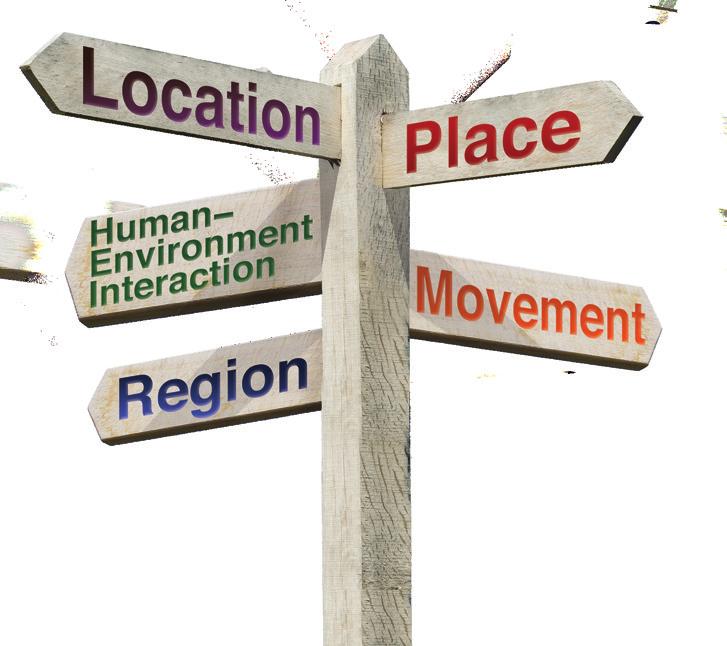
4 Weekly Structure How to Use This Book The first two weeks of the book focus on map skills. By introducing these skills early in the year, students will have a strong foundation on which to build throughout the year. Each of the remaining 34 weeks will follow a regular weekly structure. Each week, students will study a grade-level geography topic and a location in the world. Locations may be a town, a state, a region, or the whole continent. Days 1 and 2 of each week focus on map skills. Days 3 and 4 allow students to apply information and data to what they have learned. Day 5 helps students connect what they have learned to themselves. Day 1 Reading Maps: Students will study a grade-appropriate map and answer questions about it. Day 2 Creating Maps: Students will create maps or add to an existing map. Day 3 Read About It: Students will read a text related to the topic or location for the week and answer text-dependent or photo-dependent questions about it. Day 4 Think About It: Students will analyze a chart, diagram, or other graphic related to the topic or location for the week and answer questions about it. Day 5 Geography and Me: Students will do an activity to connect what they learned to themselves. Five Themes of Geography Good geography teaching encompasses all five themes of geography: location, place, human environment interaction, movement, and region. Location refers to the absolute and relative locations of a specific point or place. The place theme refers to the physical and human characteristics of a place. Human-environment interaction describes how humans affect their surroundings and how the environment affects the people who live there. Movement describes how and why people, goods, and ideas move between different places. The region theme examines how places are grouped into different regions. Regions can be divided based on a variety of factors, including physical characteristics, cultures, weather, and political factors Days of Geography Shell Education
 Using the Practice Pages The activity pages provide practice and")


 can be found on pages 210")
5 How to Use This Book (cont.) Using the Practice Pages The activity pages provide practice and assessment opportunities for each day of the school year. Teachers may wish to prepare packets of weekly practice pages for the classroom or for homework. As outlined on page 4, each week examines one location and one geography topic. The first two days focus on map skills. On Day 1, students will study a map and answer questions about it. On Day 2, they will add to or create a map. Days 3 and 4 allow students to apply information and data from texts, charts, graphs, and other sources to the location being studied. On Day 5, students will apply what they learned to themselves. Using the Resources Rubrics for the types of days (map skills, applying information and data, and making connections) can be found on pages and in the Digital Resources. Use the rubrics to assess students work. Be sure to share these rubrics with students often so that they know what is expected of them. Shell Education Days of Geography 7


6 Name: Date: WEEK 3 DAY 1 Directions: This is a map of Africa. Use the map and scale to answer the questions. Morocco Mediterranean Sea Senegal Gambia Guinea-Bissau Sierra Leone Western Sahara Liberia Mauritania Mali Burkina Faso Guinea Ghana Côte d'ivoire Togo Equatorial Guinea South Atlantic Ocean Algeria Libya Egypt Benin Niger Nigeria Chad Central African Republic Cameroon Republic Rwanda of the Congo Gabon Democratic Republic of the Congo Angola Zambia Sudan South Sudan Tanzania Eritrea Uganda Kenya Burundi Ethiopia Mozambique Djibouti Lake Assal Somalia Mt Kilimanjaro Malawi Reading Maps 0 mi. 800 mi. Namibia Botswana Zimbabwe Madagascar South Africa Lesotho Swaziland Indian Ocean 1. What political information is provided on this map of Africa? 2. Outline the borders of the landlocked countries (countries that do not border the ocean). 3. Draw a line a between the highest point, Mt. Kilimanjaro, and the lowest point, Lake Assal. 4. Using the scale, what is the approximate distance between the two points? Shell Education Days of Geography 25
7 WEEK 5 DAY 2 Name: Date: Directions: Timbuktu was a major trading center in Medieval times. Follow the steps to complete the map. The Sahara Desert and Sahel Black Sea Creating Maps 0 mi. 800 mi. Western Sahara Laayoune Ceuta Morocco Algeria Tunisia Tunis Mediterranean Sea Tripoli Cairo Libya Sahara Desert Egypt Mauritania Nouakchott Senegal Dakar Gambia Guinea-Bissau Guinea Sierra Leone Liberia Mali Timbuktu Burkina Faso Benin Ghana Côte d'ivoire 1. Draw a route from Cairo to Timbuktu. 2. Draw a route from Tripoli to Timbuktu. South Atlantic Ocean 3. Draw a route from Tunis to Timbuktu. 4. Draw a route from Ceuta to Timbuktu. Niger Sahel 5. Use the scale to label the distance of each trade route. Chad Nigeria Ethiopia Central South African Republic Sudan Cameroon Republic Uganda of the Congo Rwanda Kenya Gabon Democratic Republic of the Congo Tanzania Angola Namibia Zambia Sudan Khartoum South Africa Challenge: Cover the names of the countries that contain part of the Sahara Desert with sticky notes. Write the names of as many countries as you can. Then, check your answers. Eritrea Somalia Burundi Malawi Zimbabwe Mozambique Madagascar Botswana Indian Ocean Days of Geography Shell Education


8 WEEK 8 DAY 3 Name: Date: Directions: Read the text, and study the photos. Then, answer the questions. The Regions of Asia Read About It Asia is the world s largest continent. It has the most land and the most people. It is so large and diverse that it is often broken into specific regions. The most common groupings are the Middle East, Central Asia, Russia and the Caucasus, South Asia, Southeast Asia, and East Asia. Scholars define regions in Asia by looking at their geography, culture, and history. Modern Middle Eastern countries all trace their ancestors back to this same area. Many, but not all, countries in the region have similar characteristics. Arabic is the common language, and Islam is a common religion. It makes sense to call this area a region. Countries within each region also develop in similar ways. Most countries in East Asia have strong industry, big cities, and high incomes. This is not true for most countries in nearby South Asia. In these cases, labeling regions is useful. They help people describe and understand what s happening across the world. 1. How are regions in Asia defined? 2. What do many of the countries of the Middle East share? 3. Can a country still be part of a region even if it does not share all the same characteristics of other countries in the region? Why or why not? Days of Geography Shell Education

9 WEEK 9 DAY 4 Name: Date: Directions: This is a map of the four earliest river valley civilizations. Study the map, and answer the questions. Sy r Black Sea an rya Da pi Cas Am S ea ya China tes Mesopotamia Pe r ze ngt Ya sia n ng es Ind us ra ph Nile d Re Egypt Yellow ar ris Tig Eu Mediterranean Sea ud Ga Think About It Early Civilizations Gu lf Se a India g on Indian Ocean Me k Arabian Sea 1. What part of the map has the most rivers? 2. In what parts of the modern world were these four civilizations located? 3. Based on their locations, which early civilizations would you expect to have the most interaction? 4. What likely resulted from that interaction, and why? Days of Geography Shell Education
10 WEEK 24 DAY 5 Name: Date: Directions: Imagine that you lost your current source of water. Brainstorm three options you might have for getting drinking water. What are the pros and cons of each option? Record your ideas in the table. Option Pros Cons Geography and Me Days of Geography Shell Education
a division of Teacher Created Materials
 Sample Pages from a division of Teacher Created Materials Thanks for checking us out. Please call us at 877-777-3450 with questions or feedback, or to order this product. You can also order this product
Making a Mental Map of the Region
 Africa Preview Making a Mental Map of the Region Draw an outline map of Africa on the next page or on a separate sheet of paper. Add a compass rose to your map, showing where north, south, east, and west
Understanding riverine wetland-catchment processes using remote sensing data and modelling
 Understanding riverine wetland-catchment processes using remote sensing data and modelling Yunqing Xuan (UNESCO-IHE, NL) Didier Haguma (KIST, Rwanda) William Niyonzima (UNESCO-IHE, NL) Ann van Griensven
North-South Gap Mapping Assignment Country Classification / Statistical Analysis
 North-South Gap Mapping Assignment Country Classification / Statistical Analysis Due Date: (Total Value: 55 points) Name: Date: Learning Outcomes: By successfully completing this assignment, you will be
GINA Children. II Global Index for humanitarian Needs Assessment (GINA 2004) Sheet N V V VI VIII IX X XI XII XII HDR2003 HDR 2003 UNDP
 Sheet N V V VI VIII IX X XI XII XII HDR2003 HDR 2003 UNDP") Human UNICEF Index Index Natural 2003 GDP per Total as % of Total Rate HDI HPI Disasters Conflicts capita Population population 5 1 Congo, Democratic Republic of the 2,80000 3 3 1 3 3 3 3 3 3 3 2 Burundi
Human UNICEF Index Index Natural 2003 GDP per Total as % of Total Rate HDI HPI Disasters Conflicts capita Population population 5 1 Congo, Democratic Republic of the 2,80000 3 3 1 3 3 3 3 3 3 3 2 Burundi
1. CLIMATIC AND ENVIRONMENTAL CONDITIONS OVER AFRICA. 1.1 Inter-Tropical Discontinuity (ITD)
") African Centre of Meteorological Application for Development Centre Africain pour les Applications de la Météorologie au Développement OCTOBER 2011 HIGHLIGHT: Cholera, Acute Water Diarrhoea, Yellow fever,
African Centre of Meteorological Application for Development Centre Africain pour les Applications de la Météorologie au Développement OCTOBER 2011 HIGHLIGHT: Cholera, Acute Water Diarrhoea, Yellow fever,
Cambridge International Examinations Cambridge Ordinary Level
 Cambridge International Examinations Cambridge Ordinary Level *2207173583* GEOGRAPHY 2217/13 Paper 1 May/June 2017 Candidates answer on the Question Paper. Additional Materials: Calculator Ruler 1 hour
AS (GEOGRAPHY 1.4)
") AS 91010 (GEOGRAPHY 1.4) Apply concepts and basic geographic skills to demonstrate understanding of a given environment Externally assessed 4 credits Copy correctly Up to 3% of a workbook Copying or scanning
AS 91010 (GEOGRAPHY 1.4) Apply concepts and basic geographic skills to demonstrate understanding of a given environment Externally assessed 4 credits Copy correctly Up to 3% of a workbook Copying or scanning
The Effect of Sea Access on Economic Income Level in African Nations
 University of Nebraska - Lincoln DigitalCommons@University of Nebraska - Lincoln Nebraska Anthropologist Anthropology, Department of 2011 The Effect of Sea Access on Economic Income Level in African Nations
PTV Africa City Map 2017 (Standardmap)
") PTV Africa City Map 2017 (Standardmap) Map version name (Core) Map version name (Logistic) Release date (Logistics) Map version name (Logistics) (new) PTV_Africa_City_Map_2017 Data provider(s) Technology
PTV Africa City Map 2017 (Standardmap) Map version name (Core) Map version name (Logistic) Release date (Logistics) Map version name (Logistics) (new) PTV_Africa_City_Map_2017 Data provider(s) Technology
Supplementary Appendix for. Version: February 3, 2014
 Supplementary Appendix for When Do Governments Resort to Election Violence? Version: February 3, 2014 This appendix provides supplementary information not included in the published draft. Supplementary
PTV Africa City Map (Standardmap)
") PTV Africa City Map 2018.2 (Standardmap) Map version name (Core) Map version name (Logistic) Release date (Logistics) Map version name (Logistics) (new) PTV_Africa_City_Map_2018.2 Data provider(s) Technology
PTV Africa City Map 2018.2 (Standardmap) Map version name (Core) Map version name (Logistic) Release date (Logistics) Map version name (Logistics) (new) PTV_Africa_City_Map_2018.2 Data provider(s) Technology
African requirements for SDI standardization Antony Cooper Operating Unit Fellow Built Environment CSIR PO Box 395, Pretoria, 0001, South Africa
 ISO/TC 211 workshop on spatial data infrastructures (SDIs) African requirements for SDI standardization Antony Cooper Operating Unit Fellow Built Environment CSIR PO Box 395, Pretoria, 0001, South Africa
Lesson Plans. Geography. Grade 9. Mrs. Newgard. Monday, February 22
 Monday, February 22 o Objective: Compare and Contrast two African regions South African Map Quiz South Africa Current Events Lesson Plans Geography Grade 9 Mrs. Newgard Tuesday, February 23 relationships
INDEX REPORT MO IBRAHIM FOUNDATION
 2017 IBRAHIM INDEX OF AFRICAN GOVERNANCE INDEX REPORT MO IBRAHIM FOUNDATION 2017 IBRAHIM INDEX OF AFRICAN GOVERNANCE INDEX REPORT MO IBRAHIM FOUNDATION Contents General overview Framework of the 2017
Mexico, Central America and the Caribbean South America
 Objective: This assignment is a way to prepare you for many different aspects of AP Human Geography. You will be held accountable for this assignment; it will be the first grade of the quarter. Failure
Situation on the death penalty in the world. UNGA Vote 2012 Resolutio n 67/176. UNGA Vote 2010 Resolutio n 65/206. UNGA Vote 2008 Resolutio n 63/168
 Situation on the death penalty in the world Prepared by the International Commission against the Death Penalty (ICDP), as of 8 June 2014. Based on Amnesty International and Death Penalty Worldwide. Country
World Geography to ALL Students book (teacher book).
.") Sample Pages are from the What I Need to Know to Successfully Teach World Geography to ALL Students book (teacher book). This book contains the content in the student book, the reformatted Standards for
Sample Pages are from the What I Need to Know to Successfully Teach World Geography to ALL Students book (teacher book). This book contains the content in the student book, the reformatted Standards for
SHaSA. Strategy for the Harmonization of Statistics in Africa
 BANQUE AFRICAINE DE DEVELOPPEMENT AFRICAN DEVELOPMENT FUND Strategy for the Harmonization of Statistics in Africa Strategy for the Harmonization of Statistics in Africa 2017-2026 SHaSA Multi-Year Action
relationships between physical environments an society o Objective: Connect issues going on in East Africa with the United States Bell Ringer
 Monday, February 1 o Objective: Show the knowledge of East Africa s physical land and culture 21.2 Quiz Eastern Africa country and capital quiz Research current event articles in East Africa Watch CNN
PROPOSED BUDGET FOR THE PROGRAMME OF WORK OF THE CONVENTION ON BIOLOGICAL DIVERSITY FOR THE BIENNIUM Corrigendum
 CBD Distr. GENERAL UNEP/CBD/COP/11/10/Corr.1 6 October ORIGINAL: ENGLISH CONFERENCE OF THE PARTIES TO THE CONVENTION ON BIOLOGICAL DIVERSITY Eleventh meeting Hyderabad, India, 8-19 October Item 14.2 of
Most Recent Periodic Report Initial State Report. Next Periodic Accession/Ratification. Report Publication Publication. Report Due
 Country Signature Most Recent Periodic Report Initial State Report Next Periodic Accession/Ratification Report Publication Publication Report Due Number Date Afghanistan 4 Feb 1985 1 Apr 1987 25 Jun 1992
Appendices. Please note that Internet resources are of a time-sensitive nature and URL addresses may often change or be deleted.
 Appendices Appendix A Table of Treaties Appendix B State Trademark Registration Provisions Appendix C Resources Appendix D Forms Appendix Appendix E Selected Statutes Please note that Internet resources
A Correlation of. Eastern Hemisphere. Ohio s Learning Standards Social Studies: K-12 Grade 6
 A Correlation of Eastern Hemisphere To Grade 6 to,, Grade 6 Introduction This document demonstrates how, Eastern Hemisphere, Ohio Edition, meets : K-12 Social Studies for Grade 6. Correlation page references
The Heterogeneous Effects of Transportation Infrastructure: Evidence from Sub-Sahara Africa
 Introduction Data Estimation Conclusion Public Disclosure Authorized The Heterogeneous Effects of Transportation Infrastructure: Evidence from Sub-Sahara Africa Remi Jedwab (George Washington University)
The FAO Africover Project and a Possibility of a Unified Geodetic Datum for Africa (UGDA)
") Distr.: LIMITED ECAlNRD/CART.9/0RG.30 Add. 1 October 1996 Original: ENGLISH \ Ninth United Nations Regional Cartographic Conference for Africa Addis Ababa, Ethiopia 11-15 November 1996 The FAO Africover
Distr.: LIMITED ECAlNRD/CART.9/0RG.30 Add. 1 October 1996 Original: ENGLISH \ Ninth United Nations Regional Cartographic Conference for Africa Addis Ababa, Ethiopia 11-15 November 1996 The FAO Africover
THE ROLE OF SEAMIC IN SUSTAINABLE MINERAL RESOURCES DEVELOPMENT IN AFRICA
 THE ROLE OF SEAMIC IN SUSTAINABLE MINERAL RESOURCES DEVELOPMENT IN AFRICA Ketema Tadesse Director General-SEAMIC Dar es Salaam, Tanzania August 11, 2009 SEAMIC BACKGROUND SEAMIC was established in 1977
COUHCIL. tlnited NATIONS. and SOCIAL E/CN.U/CAP.3/12 LI7O-693. Addis Ababa, 20 to 29 May April Original: ENGLISH. Distr.
 tlnited NATIONS fcohomic and SOCIAL COUHCIL Distr. LIMITED E/CN.U/CAP.3/12 2 April 1970 Original: ENGLISH ECONOMIC COMMISSION FOR AFRICA Conference of African Planners Third session Addis Ababa, 20 to
ia PU BLi s g C o M Pa K T Wa i n CD-1576
 M h M y CD-1576 o M Pa g C n ar ia PU BLi s in K T Wa i n ed National Geography Standards National Geography Standards Teachers leading discussions while completing units and activities is a prerequisite
INFLATION AND SEIGNIORAGE STUDIES IN AFRICA. A Thesis presented to the Faculty of the Graduate School at the University of Missouri-Columbia
 INFLATION AND SEIGNIORAGE STUDIES IN AFRICA A Thesis presented to the Faculty of the Graduate School at the University of Missouri-Columbia In Partial Fulfillment of the Requirements for the Degree Master
The Chemical Weapons Convention, Biological and Toxin Weapons Convention, Geneva Protocol
 The Chemical Weapons Convention, Biological and Toxin Weapons Convention, Geneva Afghanistan 14 Jan 93 24 Sep 03 6 Mar 75 (R) 09 Dec 86 Albania 14 Jan 93 11 May 94 03 Jun 92 20 Dec 89 Algeria 13 Jan 93
Programme budget for the biennium Programme budget for the biennium
 DRAFT TEXT on SB 46 agenda item 16(a) Administrative, financial and institutional matters Programme budget for the biennium 2018 2019 Version 1 of 13 May at 12:00 Programme budget for the biennium 2018
Natural Resource Management Indicators for the Least Developed Countries
 Natural Resource Management Indicators for the Least Developed Countries Alex de Sherbinin CIESIN, Columbia University 24 June 2005 Millennium Challenge Corporation workshop Brookings Institution Washington,
Central Valley School District Social Studies Curriculum Map Grade 7. August - September
 August - September Geographical/Historical Skills Identify and analyze timelines. Construct and use cause and effect charts. Differentiate between fact and opinion. Use of word webs, flip charts, outlines
Developing Spatial Data Infrastructure (SDI) in Africa: A cooperative Geospatial information Management process
 in Africa: A cooperative Geospatial information Management process") IAMOSA Geneva 16-18 March 2011 Developing Spatial Data Infrastructure (SDI) in Africa: A cooperative Geospatial information Management process United Nations Economic Commission for Africa ICT and Sciences
IAMOSA Geneva 16-18 March 2011 Developing Spatial Data Infrastructure (SDI) in Africa: A cooperative Geospatial information Management process United Nations Economic Commission for Africa ICT and Sciences
Chapter 8 - Appendixes
 Chapter 8 - Appendixes Appendix 8.. Individual Preferences for Growth, Environment, and Income Distribution Funds to be invested in projects that Funds to be invested in projects to Funds to be invested
Modeling the EU s Everything But Arms Initiative for the Least Developed Countries
 Modeling the EU s Everything But Arms Initiative for the Least Developed Countries Michael Trueblood and Agapi Somwaru U.S. Dept. of Agriculture Economic Research Service Markets and Trade Analysis Division
Immigrant Status and Period of Immigration Newfoundland and Labrador 2001 Census
 and Period of Immigration Census - Total - Place of birth of respondent 8,985 8,030 1,635 1,510 1,700 1,165 2,015 880 1,130 955 Americas 2,165 1,835 210 445 635 225 315 140 175 335 North America 1,995
Spatial Correlation of Tuberculosis (TB) Incidents to the MODIS LST Biophysical Signature of African Countries
 Incidents to the MODIS LST Biophysical Signature of African Countries") Spatial Correlation of Tuberculosis (TB) Incidents to the MODIS LST Biophysical Signature of African Countries Andreas Tsatsaris #1, George Miliaresis #2 Department of Surveying Engineering, Technological
Spatial Correlation of Tuberculosis (TB) Incidents to the MODIS LST Biophysical Signature of African Countries Andreas Tsatsaris #1, George Miliaresis #2 Department of Surveying Engineering, Technological
Alleghany County Schools Curriculum Guide GRADE/COURSE: World Geography
 GRADE/COURSE: World 2013-14 GRADING PERIOD: 1 st Six Weeks Time Frame Unit/SOLs SOL # Strand Resource Assessment 8 days* The student will use maps, globes, satellite images, photographs, or diagrams to
BALKAN INTERNATIONAL GEOGRAPHY OLYMPIAD June 24 - June 29, 2018 IAȘI, ROMANIA WRITTEN TEST (J)
") BALKAN INTERNATIONAL GEOGRAPHY OLYMPIAD June 24 - June 29, 2018 IAȘI, ROMANIA WRITTEN TEST (J) INSTRUCTIONS FOR THE STUDENTS: 1. This written test includes the source materials, the questions and the space
BALKAN INTERNATIONAL GEOGRAPHY OLYMPIAD June 24 - June 29, 2018 IAȘI, ROMANIA WRITTEN TEST (J) INSTRUCTIONS FOR THE STUDENTS: 1. This written test includes the source materials, the questions and the space
Climate variability and international migration: an empirical analysis
 Climate variability and international migration: an empirical analysis NICOLA D. CONIGLIO, Corresponding author University of Bari Aldo Moro, Department of Economics, Largo Abbazia Santa Scolastica 53,
Appendix - Legal Origins and Female HIV
 Appendix - Legal Origins and Female HIV Siwan Anderson Vancouver School of Economics and CIFAR December 2017 A1. Figures Figure A1 Population Density (people/square km) by Ethnic Group 1 A2. Data Sources
Mapping African buffalo distributions, in relation to livestock disease risk
 Mapping African buffalo distributions, in relation to livestock disease risk Tim Robinson and Jennifer Siembieda Buffalo Mapping Meeting 7-8 June, Rome FAO, Canada Room Overview Modelling densities of
Discovering the World of Geography
 Discovering the World of Geography Grades 7 8 By MYRL SHIREMAN COPYRIGHT 2003 Mark Twain Media, Inc. ISBN 10-digit: 1-58037-230-9 13-digit: 978-1-58037-230-5 Printing No. CD-1576 Mark Twain Media, Inc.,
Map Skills Test. 1. What do we call a person who makes maps? a. mapographer b. cartographer c. geologist d. archaeologist
 Map Skills Test 1. What do we call a person who makes maps? a. mapographer b. cartographer c. geologist d. archaeologist 2. What is the name of the 0 latitude line? a. Equator b. Arctic Circle c. First
Institutions and the Economic Development of Africa. Colnot Louis, Patel Arpit, Strang Stephen. Georgia Institute of Technology
 Institutions and the Economic Development of Africa Colnot Louis, Patel Arpit, Strang Stephen Georgia Institute of Technology Abstract: This paper explores the effect of institutions on the economic development
Patent Cooperation Treaty (PCT) Working Group
 Working Group") E PCT/WG/7/26 ORIGINAL: ENGLISH DATE: MAY 21, 2014 Patent Cooperation Treaty (PCT) Working Group Seventh Session Geneva, June 10 to 13, 2014 FEE REDUCTIONS FOR CERTAIN APPLICANTS FROM CERTAIN COUNTRIES,
E PCT/WG/7/26 ORIGINAL: ENGLISH DATE: MAY 21, 2014 Patent Cooperation Treaty (PCT) Working Group Seventh Session Geneva, June 10 to 13, 2014 FEE REDUCTIONS FOR CERTAIN APPLICANTS FROM CERTAIN COUNTRIES,
6 th Grade: Regions and People of the World ESC Suggested Pacing Guide
 6 th Grade: Regions and People of the World ESC Suggested Pacing Guide 2008-09 The sixth grade year focuses on the study of world regions. The concentration is geographic rather than historic. Students
Overview of past procurement of Solar Direct Drive (SDD) refrigeration systems and UNICEF SD support in Cold Chain
 refrigeration systems and UNICEF SD support in Cold Chain") Overview of past procurement of Solar Direct Drive (SDD) refrigeration systems and UNICEF SD support in Cold Chain 1 UNICEF Supply Does Make a Difference The overall objectives include: Shorten procurement
Overview of past procurement of Solar Direct Drive (SDD) refrigeration systems and UNICEF SD support in Cold Chain 1 UNICEF Supply Does Make a Difference The overall objectives include: Shorten procurement
AP Human Geography (HuG): Introduction & Summer Assignment
: Introduction & Summer Assignment") 1 AP HuG Summer Work 18 Welcome To AP Human Geography AP Human Geography (HuG): Introduction & Summer Assignment Please read all of the information in this packet as it is designed to help you understand
1 AP HuG Summer Work 18 Welcome To AP Human Geography AP Human Geography (HuG): Introduction & Summer Assignment Please read all of the information in this packet as it is designed to help you understand
Tables of Results 21
 Tables of Results 21 Tables of Results 23 2005 ICP Global Results: Summary Table Price GDP per GDP per capita Gross domestic Gross domestic level capita indices indices product per capita product, billions
a. Hunting and gathering SE/TE: 17, 19, 21, 22, 23, 25, 30 b. Tool making SE/TE: 17, 18, 19, 22, 23 c. Use of fire SE/TE: 17, 23, 30
 Ohio Academic Content Standards, Social Studies, Benchmarks and Indicators (Grade 6) Grade Six History Students use materials drawn from the diversity of human experience to analyze and interpret significant
SECOND GENERATION SEASONAL CLIMATE OUTLOOK PROGRAMME
 Page 1/5 CENTRE AFRICAIN POUR LES APPLICATIONS DE LA METEOROLOGIE AU DEVELOPPEMENT AFRICAN CENTRE OF METEOROLOGICAL APPLICATIONS FOR DEVELOPMENT Institution Africaine parrainée par la CEA et l OMM African
Countries in Order of Increasing Per Capita Income, 2000
 ,400 45000,200 Population Per Capita Income 40000 35000,000 30000 Population, millions 800 600 25000 20000 Per Capita Income 5000 400 0000 200 5000 0 2 3 4 5 6 7 8 9 0 2 3 4 5 6 7 Countries in Order of
Grade 7 Social Studies
 Standard 1: History Students will examine the major movements, events, and figures that contributed to the development of nations in modern Africa, Asia, and the Southwest Pacific from acient civilizations
SUGAR YEAR BOOK INTERNATIONAL SUGAR ORGANIZATION 1 CANADA SQUARE, CANARY WHARF, LONDON, E14 5AA.
 SUGAR YEAR BOOK 2017 INTERNATIONAL SUGAR ORGANIZATION 1 CANADA SQUARE, CANARY WHARF, LONDON, E14 5AA www.isosugar.org Copyright 2017 International Sugar Organization All rights reserved. No part of ISO
Erratum to: Policies against human trafficking: the role of religion and political institutions
 Econ Gov (2016) 17:387 396 DOI 10.1007/s10101-016-0185-1 ERRATUM Erratum to: Policies against human trafficking: the role of religion and political institutions Niklas Potrafke 1,2 Published online: 16
Velocity Virtual Rate Card 2018
 Local 0.26 0.00 0.26 Local National 0.26 0.00 0.26 National Mobile 0.26 0.00 0.26 Mobile AFGHANISTAN ALBANIA 2.20 0.00 2.20 International ALGERIA 2.20 0.00 2.20 International ANDORRA 2.20 0.00 2.20 International
Scaling Seed Kits Through Household Gardens
 Scaling Seed Kits Through Household Gardens SENEGAL WESTERN SAHARA LIBERIA PORTUGAL REPULIC OF IRELAND COTE D IVOIRE UNITED KINGDOM GHANA NETHERLANDS BELGIUM DENMARK SWITZ. TUNISIA CAMEROON CZECH REPUBLIC
GIS AS A TOOL FOR DEVELOPMENT: ITS SPECIAL NATURE AND CHARACTERISTICS
 Creating Value through Geographical Labeling and Indications: The Power of Origin GIS AS A TOOL FOR DEVELOPMENT: ITS SPECIAL NATURE AND CHARACTERISTICS P R O F E S S O R R U T H O K E D I J I N O V E M
Export Destinations and Input Prices. Appendix A
 Export Destinations and Input Prices Paulo Bastos Joana Silva Eric Verhoogen July 2017 Appendix A For Online Publication Figure A1. Real exchange rate, selected richer destinations relative price level
International legal instruments related to the prevention and suppression of international terrorism
 III. International legal instruments related to the prevention and suppression of international terrorism A. Status of international conventions pertaining to international terrorism 138. Currently, there
Delegations School GA Opening Speech 1 SPC Opening Speech 2 SC Total Amnesty International Agora Sant Cugat Botswana Agora Sant Cugat 1 Y 1 Y
 Amnesty International Agora Sant Cugat 1 1 0 2 Botswana Agora Sant Cugat 1 Y 1 Y 0 2 Cameroon Agora Sant Cugat 1 Y 1 Y 0 2 Cuba Agora Sant Cugat 1 Y 1 Y 0 2 Indonesia Agora Sant Cugat 1 Y 1 Y 0 2 Israel
Does socio-economic indicator influent ICT variable? II. Method of data collection, Objective and data gathered
 Does socio-economic indicator influent ICT variable? I. Introduction This paper obtains a model of relationship between ICT indicator and macroeconomic indicator in a country. Modern economy paradigm assumes
PROPOSED BUDGET FOR THE PROGRAMME OF WORK OF THE CARTAGENA PROTOCOL ON BIOSAFETY FOR THE BIENNIUM Corrigendum
 CBD CONFERENCE OF THE PARTIES TO THE CONVENTION ON BIOLOGICAL DIVERSITY SERVING AS THE MEETING OF THE PARTIES TO THE CARTAGENA PROTOCOL ON BIOSAFETY Fifth meeting, Nagoya, Japan, 11-15 October 2010 Item
GSAf was founded in 1973 at the Haile Sellassie 1 st University in Addis Ababa, Ethiopia GSAf has the following objectives: To promote the
 GSAf was founded in 1973 at the Haile Sellassie 1 st University in Addis Ababa, Ethiopia GSAf has the following objectives: To promote the development of geosciences in Africa. To promote the sustainable
COMMITTEE ON FISHERIES
 September 2017 COFI:AQ/IX/2017/SBD.12 E COMMITTEE ON FISHERIES SUB-COMMITTEE ON AQUACULTURE Ninth Session Rome, 24 27 October 2017 REGIONAL STATISTICAL ANALYSIS OF RESPONSES BY FAO MEMBERS, REGIONAL FISHERIES
Some Very Helpful Boundary and Border Definitions
 Some Very Helpful Boundary and Border Definitions Key Terms and Definitions: Boundary - something that indicates bounds or limits. Boundary Delimitation - political boundaries on Earth's surface are determined
Grade 6 Social Studies
 Unit Title: Africa : Movement Location Place Human Region : Subject/Course: 6 th Grade Social Studies Essential Questions: peoples, cultures and ideas of the world? How is a location identified using map
6 th Grade: Regions and People of the World ESC Suggested Pacing Guide
 Norton City Schools Standards-Based Social Studies Course of Study 2005 6 th Grade: Regions and People of the World ESC Suggested Pacing Guide 2005-06 The sixth grade year focuses on the study of world
November 2014 CL 150/LIM 2 COUNCIL. Hundred and Fiftieth Session. Rome, 1-5 December 2014
 November 2014 CL 150/LIM 2 E COUNCIL Hundred and Fiftieth Session Rome, 1-5 December 2014 Status of Current Assessments and Arrears as at 24 November 2014 Executive Summary The document presents the Status
COUNCIL. Hundred and Fifty-eighth Session. Rome, 4-8 December Status of Current Assessments and Arrears as at 27 November 2017
 November 2017 CL 158/LIM/2 E COUNCIL Hundred and Fifty-eighth Session Rome, 4-8 December 2017 Status of Current Assessments and Arrears as at 27 November 2017 Executive Summary The document presents the
Linking Global and Regional Levels in the Management of Marine Areas Beyond National Jurisdiction
 Linking Global and Regional Levels in the Management of Marine Areas Beyond National Jurisdiction South Atlantic Region Session 4: «Experiences, Priorities and Opportunities in the South Atlantic and Indian
TRADE REGIONALISATION AND OPENNESS IN AFRICA
 TRADE REGIONALISATION AND OPENNESS IN Lelio Iapadre (Associate professor of international economics, University of L Aquila, and Professorial lecturer in international economics, Johns Hopkins University,
a division of Teacher Created Materials
 Sample Pages from a division of Teacher Created Materials Thanks for checking us out. Please call us at 877-777-340 with questions or feedback, or to order this product. You can also order this product
To use the Law of Detachment and the Law of Syllogism
 2-4 Deductive Reasoning Common Core State Standards Prepares for G-CO.C.9 Prove theorems about lines and angles. Also Prepares for G-CO.C.10, G-CO.C.11 MP 1, MP 2, MP 3, MP 4 Objective To use the Law of
Report by the Secretariat
 SIXTY-FIFTH WORLD HEALTH ASSEMBLY A65/30 Provisional agenda item 16.3 5 April 2012 Status of collection of assessed contributions, including Member States in arrears in the payment of their contributions
Grade Level Expectations for the Sunshine State Standards
 for the Sunshine State Standards FLORIDA DEPARTMENT OF EDUCATION http://www.myfloridaeducation.com/ The sixth grade student: Time, Continuity, and Change [History] understands that historical events are
Hundred and Fifty-sixth Session. Rome, 3-7 November Status of Current Assessments and Arrears as at 30 June 2014
 September 2014 FC 156/INF/2 E FINANCE COMMITTEE Hundred and Fifty-sixth Session Rome, 3-7 November 2014 Status of Current Assessments and Arrears as at 30 June 2014 Queries on the substantive content of
Research Exercise 1: Instructions
 Research Exercise 1: Instructions Instructions: 1. Cross-national scatter plots of trade openness and economic performance. a. Create a scatter plot with some measure of trade openness on the x-axis and
Solow model: Convergence
 Solow model: Convergence Per capita income k(0)>k* Assume same s, δ, & n, but no technical progress y* k(0)=k* k(0) k Assume same s, δ, &
1. Match the words in the first column to the meaning in the second column. [5]
![1. Match the words in the first column to the meaning in the second column. [5]](/thumbs/96/126839765.jpg "1. Match the words in the first column to the meaning in the second column. [5]") Exercise 1: [40 POINTS] 1. Match the words in the first column to the meaning in the second column. [5] Equator Around earth between the Equator and the Poles. Greenwich meridian Half of earth. Longitude
Exercise 1: [40 POINTS] 1. Match the words in the first column to the meaning in the second column. [5] Equator Around earth between the Equator and the Poles. Greenwich meridian Half of earth. Longitude
SOCIAL STUDIES GRADE 6. I Can Checklist REGIONS AND PEOPLE OF THE EASTERN HEMISPHERE. Office of Teaching and Learning Curriculum Division
 SOCIAL STUDIES REGIONS AND PEOPLE OF THE EASTERN HEMISPHERE GRADE 6 I Can Checklist 2018-2019 Aligned with Ohio s Learning Standards for Social Studies Office of Teaching and Learning Curriculum Division
COUNCIL. Hundred and Fifty-fifth Session. Rome, 5-9 December Status of Current Assessments and Arrears as at 29 November 2016.
 November 2016 CL 155/LIM/2 E COUNCIL Hundred and Fifty-fifth Session Rome, 5-9 December 2016 Status of Current Assessments and Arrears as at 29 November 2016 Executive Summary The document presents the
Step-by-step: Data Harmonisation Process
 Step-by-step: Data Harmonisation Process Anja Neundorf (University of Nottingham) 1 Rosalind Shorrocks (University of Manchester) 1 September 2017 Part of the ESRC-funded project Legacies of Authoritarian
September 14, 2013 Objective: How does geography impact history? What important features exist that have shaped societies?
 Lowenhaupt 1 September 14, 2013 Objective: How does geography impact history? What important features exist that have shaped societies? Warm-Up: In your binder, answer the following question: Imagine you
Cambridge International Examinations Cambridge International General Certificate of Secondary Education
 Cambridge International Examinations Cambridge International General Certificate of Secondary Education *6550524820* GEOGRAPHY 0460/22 Paper 2 May/June 2018 Candidates answer on the Question Paper. Additional
University of Oklahoma, Norman Campus International Student Report Fall 2014
 International Student Report Fall 2014 Prepared by Institutional Research & Reporting June 2015 http://www.ou.edu/content/irr/data-center/annual-reports.html International Student Report Notes and Definitions
FAO DESERT LOCUST BULLETIN No. 139 GENERAL SITUATION DURING MARCH 1990 FORECAST UNTIL MID MAY 1990
 1 FAO DESERT LOCUST BULLETIN No. 139 GENERAL SITUATION DURING MARCH 1990 FORECAST UNTIL MID MAY 1990 The current recession continues with very few reports of Desert Locusts received during March and no
A MULTIDIMENSIONAL SCALING APPROACH TO HUMAN DEVELOPMENT CLASSIFICATION OF AFRICAN COUNTRIES.
 African Journal of Science and Research,2015,(3)7:15-19 ISSN: 2306-5877 Available Online: http://ajsr.rstpublishers.com/ A MULTIDIMENSIONAL SCALING APPROACH TO HUMAN DEVELOPMENT CLASSIFICATION OF AFRICAN
Africa, Asia and the Pacific, Latin America and the Caribbean. Africa, Asia and the Pacific, Latin America and the Caribbean
 ANNEXE I (disponible en anglais) UNESCO/POLAND CO-SPONSORED FELLOWSHIPS PROGRAMME 2017 List of Invited Member States per region and field of research as determined by the Polish authorities Project (Number
SOCIAL STUDIES Grade 6 Standard: History
 Standard: History Chronology A. Interpret relationships between events shown on multipletier 1. Construct a multiple-tier time line from a list of events time lines. and interpret the relationships between
ProxiWorld tariffs & zones 2016
 made sent Internet zones Afghanistan 0,91 0,99 2,27 2,89 0 0,1 0,62 0,62 12 3 Albania 0,7 0,91 1,65 2,27 0 0,1 0,62 0,62 12 2 Algeria 0,7 0,91 1,65 2,27 0 0,1 0,62 0,62 12 2 Andorra 0,7 0,91 1,65 2,27
Written Response Test
 12 th International Geography Olympiad Tver, Russia 11 17 August 2015 Written Response Test Question and Answer Booklet Do NOT open the Booklet before instructed to do so by a supervisor. Name:... Team:...
INTERNATIONAL TELECOMMUNICATION UNION SERIES T: TERMINALS FOR TELEMATIC SERVICES
 INTERNATIONAL TELECOMMUNICATION UNION TELECOMMUNICATION STANDARDIZATION SECTOR OF ITU T.35 (02/2000) SERIES T: TERMINALS FOR TELEMATIC SERVICES Procedure for the allocation of ITU-T defined codes for non-standard
GRADE 6 SOCIAL STUDIES SOCIAL STUDIES APPLICATION. SOCIAL STUDIES STANDARDS for Grade 6
 GRADE 6 SOCIAL STUDIES The Archdiocese of Cincinnati has established the following Social Studies standards based on the most current teachings which are aligned to Ohio New Learning Social Studies Standards.
GEF Corporate Scorecard. May 2018
 GEF Corporate Scorecard May 218 GEF CORPORATE SCORECARD May 22, 218 Contributions to the Generation of Global Environment Benefits During the GEF 6 replenishment, the GEF 6 focal area strategies were
Yodekoo Business Pro Tariff (Including Quickstart Out Of Bundle)
") Yodekoo Business Pro Tariff (Including Quickstart Out Of Bundle) This is the full tariff for Business Pro and any out of bundle spend using Quickstart products. All prices shown are in GBP per minute and
Yodekoo Business Pro Tariff (Including Quickstart Out Of Bundle) This is the full tariff for Business Pro and any out of bundle spend using Quickstart products. All prices shown are in GBP per minute and
GCSE 4231/01 GEOGRAPHY (Specification A) FOUNDATION TIER UNIT 1: Core Geography
 FOUNDATION TIER UNIT 1: Core Geography") Surname Centre Number Candidate Number Other Names 0 GCSE 4231/01 GEOGRAPHY (Specification A) FOUNDATION TIER UNIT 1: Core Geography S15-4231-01 P.M. TUESDAY, 19 May 2015 1 hour 45 minutes For s use Question
Surname Centre Number Candidate Number Other Names 0 GCSE 4231/01 GEOGRAPHY (Specification A) FOUNDATION TIER UNIT 1: Core Geography S15-4231-01 P.M. TUESDAY, 19 May 2015 1 hour 45 minutes For s use Question