UAS4Enviro2017 ABSTRACT BOOK. small Unmanned Aerial Systems for Environmental Research. 5th Edition June 2017 UTAD Vila Real, PORTUGAL
|
|
|
- Amos Nichols
- 5 years ago
- Views:
Transcription


1 UAS4Enviro2017 small Unmanned Aerial Systems for Environmental Research 5th Edition ABSTRACT BOOK June 2017 UTAD Vila Real, PORTUGAL ISBN:
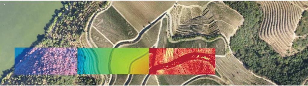
2 ADAVANTAGES OF USING UAVS DATA TO STUDY ROCKY COASTS GEOMORPHOLOGY: THE CASE STUDY OF THE SÃO PAIO ROCKY LITTORAL, PORTUGAL Lopes, Mafalda (1), Marques, Miguel (2), Coelho, Cláudia (3), Araújo, Maria Assunção (4), Gomes, Alberto (5), (1) Faculdade de Letras da Universidade do Porto, Via Panorâmica, s/n Portugal, (2) Geolevação, (3) Faculdade de Ciências da Universidade do Porto, Rua do Campo Alegre 1021/1055, Portugal, (4) Centro de Estudos de Geografia e Ordenamento do Território (FLUP), Via Panorâmica, s/n Portugal, m.a.araujo@netcabo.pt (5) Centro de Estudos de Geografia e Ordenamento do Território (FLUP), Via Panorâmica, s/n Portugal, albgomes@gmail.com Key-Words: UAVs; rocky coast; costal geomorphology; geological mapping. ABSTRACT: Rocky Coasts comprises about 80% of the coasts of the earth [1]. Along the European oceanic coast, this type of littoral constitutes 1/3 of the coast (about 3666 km) representing approximately 37% of the total length [2]. According to the same authors, 48% of the rocky coasts develop in outcrops of resistant rocks, such as granites and limestone s. Despite their relevance in quantitative terms, the rocky coasts receive less attention from the scientific community when compared to the sandy coasts. This fact is associated with urban, industrial or recreational uses and pressures [3], and the assumption of high social and economic value for the sandy coasts [4]. The studied area covers the coastal stretch of São Paio at Portugal, located at Vila do Conde municipality, 15 km at north of the Douro River and the city of Porto. It differs from the typical coast of the Porto region, generally low, since it consists of a rocky coastal stretch characterized by two massive granite small hills (Mota hill, north and the Facho hill, in the south), separated by a small beach, called Castros beach [5]. This study presents an integration of classical fieldwork with new technologies into the geomorphological and geological research of rocky coasts, namely by the acquisition and analysis of images captured by autonomous unmanned vehicle (UAV) and further processing of the collected data. From a collection of aerial photographs (5 cm of pixel size), it was made a global orthoimage of the area and produced a digital terrain and a surface model. These data were the basis for the elaboration of detailed geological and geomorphological maps, which are the main results presented. The specific characteristics of flights with an UAV (low altitude flight) allows images that offer many advantages, such as, excellent resolution, large overlap and reduced execution time [6]. In this survey, it was used a Hexacopter device (± 2700g of weight), class 550 with a controller 3dr APM for Arducopter 3.6 and with a time of operation of 12-16min. The image acquisition was performed from an UAV equipped with a conventional Canon Powershot sx260hs (12 megapixels) digital camera whose memory card has an application (CHDK-Canon Hack Development Kit) that allows shooting automatically within a certain time interval set by the user. In order to improve the quality of the images obtained, the flights were executed on 08/12/2014 and 01/23/2015, days with low cloudiness and during spring low tides, with the objective of shot in detail and 90

3 clearly the marine erosion platforms and boulders that are usually covered by the sea. A recent survey and flight was done in April of 2017, in order to evaluate the shore dynamics and changes occurred between In addition, some control points (marked with red crosses on the terrain surface and in observable positions on the aerial photographs) were also collected using a LEICA SR20 differential GPS. The subsequent tasks to process data in order to match the photos and obtain the respective DTM and DSM are briefly exposed in Fig. 1. Figure 1. Workflow of the project following the proposals of [7] and [8]. The data vectorization process began with the visual interpretation of the various geological elements according to their characteristics. Considering the contrast of colour in relation to the surrounding rock and the association with very sharp linear forms the veins were distinguished. In addition, the same recognition properties allowed the discontinuities mapping. This mapping is more difficult than the veins, since the contrast of the colour is not so obvious due to the discontinuities reveal a darker colour, a more irregular shape and smaller length and width. In addition to the exposed recognition properties, interpretation was also experimented with changes in the observation scale, mainly in the interpretation of the veins and the discontinuities, in cases in which their continuity was not perceptible. The global orthoimage allowed the definition of two dominant directions for the veins and discontinuities, NW- SE and NNW-SSE. The veins consists essentially of quartz and feldspar, corresponding to aplite-pegmatite textures, and a few number of uncommon lamprophyres veins. Some veins are rejected by short displacements or appear intermittently, but are clearly rejected. Strike-slips on the reefs are dominantly right. The pixel resolution of 5 centimetres makes it possible to identify the smallest discontinuities, as well as the fine veins. However, the high resolution and the advantage of being able to zoom in on the image sometimes becomes a difficulty, since it is often lost the notion of space and what have been mapped. Regarding to the area lithology, since we cover the inter-tidal range, the variations of colour and tonality are quite large, which does not allow distinguishing with great clarity the lithological differentiation. The field knowledge acquired from the area reveals that there is only one type of granite with slight textured differences, and a metamorphic rock basement on the southern boundary of the map. 91

4 Figure 2. Detailed geomorphological map of the São Paio littoral sector. Concerning to the geomorphology, the UAV data made it possible to recognize with high detail several coastal forms on the cliffs, on the platforms and at the granite hills that were unknown or badly characterized, giving precision to quantify their morphometric parameters (Fig. 2). Many coastal potholes at different altitudes, elongated topographic depressions and small flat surfaces were identified and mapped. With these new data, it was possible to distinguished clearly four geomorphological sectors that are quite evident on the longitudinal profiles and illustrates the huge altimetry variation of the surface, mainly due to discontinuities explored by the marine erosion. In conclusion, the quality of the orthoimage obtained by the aerial photographs of the UAV to perform detailed cartography on this rocky coast was excellent. One great advantage comes from the precise and detailed characterization of geological and geomorphological features exposed in this work, such as the diversified 92
5 veins, cliffs, erosion platforms, notches, coastal boulders, littoral potholes and even old deposits, in addition to the current sediments. The use of UAVs in comparison with other data acquisition techniques is very advantageous since the costs and time spent in collecting and processing the data are relatively short. Processing images can even be carried out on-site, which allows an immediate result to be visualized and facilitates the correction of errors through repeated flights. Given these characteristics and the improvement of the geological interpretation of the rocky sector of São Paio obtained with these new data, it is assumed that the acquisition of data from this costal environment constitutes an important technique to apply in the studies of rocky coasts, especially for geomorphological studies [9], and possibly also for risk mapping. The flight easiness repetition and speed of data processing makes it accessible tool and very effective in monitoring and managing the rocky coasts. References: 1. Emery, K.O. & Kuhn, G.G. (1982). Sea cliffs: their processes, profiles, and classification. Geological in the Society of America Bulletin. 93, Gómez-Pujol, L., Pérez-Alberti, A., Blanco-Chao, R., Costa, S., Neves, M. & Río, Laura Del (2014). The rock coast of continental Europe in the Atlantic. Rock Coast Geomorphology: A Global Synthesis. Geological Society, Memoirs 2014, 40, Sunamura, T (1992). Introduction. In Geomorphology of rocky coasts. Wiley, Naylor, L.A., Stephenson, W.J. & Trenhaile, A.S. (2010). Rock coast geomorphology: Recent advances and future research directions. Geomorphology, 114, Araújo, M. A., Teixeira, J., Marques, M. (2014). A área do S. Paio (Labruge, Vila do Conde): desafios científicos e uso de novas tecnologias. Atas do XIV Congresso Ibérico de Geografia, Humphrey, D. (2014). UAV and GIS, an emerging dynamic duo. Available at < 7. Sabins, F. (2007). Introduction to concepts and systems In Remote Sensing: Principles and Applications. Waveland Press, Kaneko, K. & Nohara, S. (2014). Review of Effective Vegetation Mapping Using the UAV (Unmanned Aerial Vehicle) Method. Journal of Geographic Information System, 6, Pérez-Alberti, A. & Trenhaile, A.S. (2015). An initial evaluation of drone-based monitoring of boulder beaches in Galicia, north-western Spain. Earth Surface Processes and Landforms, 40 (1),
GEOMATICS. Shaping our world. A company of
 GEOMATICS Shaping our world A company of OUR EXPERTISE Geomatics Geomatics plays a mayor role in hydropower, land and water resources, urban development, transport & mobility, renewable energy, and infrastructure
PHOTOGRAMMETRY AND GIS TECHNOL 1 OGIES FOR MONITORING COASTAL EROSION ALONG DAR ES SALAAM COASTLINE. By: Z.Y Masele, S.D Mayunga1.
 PHOTOGRAMMETRY AND GIS TECHNOL 1 OGIES FOR MONITORING COASTAL EROSION ALONG DAR ES SALAAM COASTLINE. By: Z.Y Masele, S.D Mayunga1 Abstract Dar Es salaam coastline is seriously suffering from coastal soil
Holocene evolution of Dahab coastline Gulf of Aqaba, Sinai Peninsula, Egypt 1
 Holocene evolution of Dahab coastline Gulf of Aqaba, Sinai Peninsula, Egypt 1 Magdy Torab* 2 * Prof. of Geomorphology, Department of Geography, Damanhour University, Egypt 3 E-mail: magdytorab@hotmail.com.
Spanish national plan for land observation: new collaborative production system in Europe
 ADVANCE UNEDITED VERSION UNITED NATIONS E/CONF.103/5/Add.1 Economic and Social Affairs 9 July 2013 Tenth United Nations Regional Cartographic Conference for the Americas New York, 19-23, August 2013 Item
An initial evaluation of drone-based monitoring of boulder beaches in Galicia, north-western Spain
 EARTH SURFACE PROCESSES AND LANDFORMS Earth Surf. Process. Landforms (2014) Copyright 2014 John Wiley & Sons, Ltd. Published online in Wiley Online Library (wileyonlinelibrary.com) DOI: 10.1002/esp.3654
GLY Coastal Geomorphology Notes
 GLY 4734 - Coastal Geomorphology Notes Dr. Peter N. Adams Spring 2011 2 Coastal Classification In this lecture, we discuss some successful classification schemes of the coastal landscape, and pay particular
Integrating LiDAR data into the workflow of cartographic representation.
 Integrating LiDAR data into the workflow of cartographic representation. Cartographic Workflow I. 1 2 3 4 5 Surveying Vector (Nat. GDB) GPS, Laser Range Finder Yes/ No Scanning old maps LiDARflights Capture
name and locate the world s seven continents and five oceans
 Subject: Geography Activities National Curriculum Objectives One Progression of Skills Name the 7 continents and 5 oceans 3D Jigsaw task to locate continents and seas name and locate the world s seven
Analysis of the Portuguese west coast morphology and morphodynamics, based on aerial images and GIS tools
 Analysis of the Portuguese west coast morphology and morphodynamics, based on aerial images and GIS tools Joaquim Pais Barbosa, Fernando Veloso Gomes & Francisco Taveira Pinto University of Porto, Faculty
Neotectonic Implications between Kaotai and Peinanshan
 Neotectonic Implications between Kaotai and Peinanshan Abstract Longitudinal Valley was the suture zone between the Philippine Sea plate and the Eurasia plate. Peinanshan was the southest segment of the
Physical Geography: Patterns, Processes, and Interactions, Grade 11, University/College Expectations
 Geographic Foundations: Space and Systems SSV.01 explain major theories of the origin and internal structure of the earth; Page 1 SSV.02 demonstrate an understanding of the principal features of the earth
Photogrammetric Methods for Monitoring Cliffs with Low Retreat Rate
 Journal of Coastal Research SI 56 1577-1581 ICS2009 (Proceedings) Portugal ISSN 0749-0258 Photogrammetric Methods for Monitoring Cliffs with Low Retreat Rate P. Redweik, R. Matildes, F. Marques and L.
CE6301 ENGINEERING GEOLOGY UNIT I 2 MARKS
 YEAR : II SEMESTER : III DEPARTMENT : CIVIL CE6301 ENGINEERING GEOLOGY UNIT I 1. What is Physical weathering? 2. Define Stratigraphy and Palaeontology? 3. What is meant by chemical weathering 4. Describe
Applications of GIS in assessing Coastal Change Rachel Hehre November 30, 2004 NRS 509 OVERVIEW
 Applications of GIS in assessing Coastal Change Rachel Hehre November 30, 2004 NRS 509 OVERVIEW ITRODUCTION Due to the dynamic nature of coastal systems, representing coastal change with precision and
Phillip Island Nature Parks Coastal Process Study 8 October 2014
 Phillip Island Nature Parks Coastal Process Study 8 October 2014 Project Overview Coastal Geology Basaltic and fragmented lavas, granite at Pyramid Rock and Cape Woolamai Weathered basalt (>10m thick)
Donald K. Stauble and Bill Birkemeier Coastal and Hydraulics Laboratory US Army Corps of Engineers
 Donald K. Stauble and Bill Birkemeier Coastal and Hydraulics Laboratory US Army Corps of Engineers Define the Problem Navigation Shore Protection Environmental Political So what is the problem? Management
GEOGRAPHY - HIGHER LEVEL
 M.24 AN ROINN OIDEACHAIS AGUS EOLAÍOCHTA LEAVING CERTIFICATE EXAMINATION 2000 GEOGRAPHY - HIGHER LEVEL MONDAY, 12 JUNE AFTERNOON 2.00 TO 5.20 Four questions to be answered, namely Question 1, Question
Advanced Technologies in digital 3D-Surface, -Deposit und -Mine- Modelling
 8 th Jordanien International Mining Conference 19.09. to 21.09.2017 Ammann - Jordan Natural Resources: Projected Investment, Reality and Aspirations Dr.-Ing. Marc Dohmen, Aachen Dohmen, Herzog & Partner
Draft exercise for share fair at Bozeman workshop only. This exercise is not ready for distribution. Please send helpful suggestions to
 Draft exercise for share fair at Bozeman workshop only. This exercise is not ready for distribution. Please send helpful suggestions to foleyd@plu.edu Figure list 1. Trailer photograph 2. Location map
2012. Proceedings of the 11 European Geoparks Conference. AGA Associação Geoparque Arouca, Arouca, 5-6.
 References to this volume It is suggested that either the following alternatives should be used for future bibliographic references to the whole or part this volume: th Sá, A.A., Rocha, D., Paz, A. & Correia,
A BEACH IS A BEACH. Or Is It? Hawaii. St. Croix, US Virgin Islands
 A BEACH IS A BEACH Or Is It? Pt. Reyes, California Western Florida Hawaii AGI What is a beach? Eastern Maine A beach is a strip of shoreline washed by waves and tides. Crane Key, Florida Bay St. Croix,
3 SHORELINE CLASSIFICATION METHODOLOGY
 3 SHORELINE CLASSIFICATION METHODOLOGY Introduction The ESI scale, as described in Section 2, categorizes coastal habitats in terms of their susceptibility to spilled oil, taking into consideration a number
In 1990, 50% of the U.S. population lived within 75 km of a coast. By 2010, 75% of the U.S. population will live within 75 km of a coast.
 In 1990, 50% of the U.S. population lived within 75 km of a coast. By 2010, 75% of the U.S. population will live within 75 km of a coast. High Tech Methods for Surveying the Deep Sea Floor Fig. 20.18 1
The Geology of Sebago Lake State Park
 Maine Geologic Facts and Localities September, 2002 43 55 17.46 N, 70 34 13.07 W Text by Robert Johnston, Department of Agriculture, Conservation & Forestry 1 Map by Robert Johnston Introduction Sebago
Airborne Corridor-Mapping. Planning and documentation of company infrastructure: precise, rapid, and cost effective
 Airborne Corridor-Mapping Planning and documentation of company infrastructure: precise, rapid, and cost effective Technology Airborne Laser-Scanning, digital orthophotos and thermal imaging: one flight
R.Suhasini., Assistant Professor Page 1
 UNIT I PHYSICAL GEOLOGY Geology in civil engineering branches of geology structure of earth and its composition weathering of rocks scale of weathering soils - landforms and processes associated with river,
Case Study microdrones in Geomatics Remote Sensing
 Case Study microdrones in Geomatics Remote Sensing Version 1.0 Presented by: Carlos Espadas (INGECOR Geomática SL) & Michael Thoss (microdrones GmbH) Profiles: microdrones / Ingecor Geomática Contact information
Coastal dune consideration for erosion and marine submersion characterization along the Aquitaine coast (SW France)
") Coastal dune consideration for erosion and marine submersion characterization along the Aquitaine coast (SW France) Integrated Coastal Dune Management in Europe Case studies EUCC Merlimont, 17-19 June
Coastal dune consideration for erosion and marine submersion characterization along the Aquitaine coast (SW France) Integrated Coastal Dune Management in Europe Case studies EUCC Merlimont, 17-19 June
2) re-positioning of the SSS data, 3) individuation of geomorphological features and morphometrical parameters correlated to instability phenomena.
 re-positioning of the SSS data, 3) individuation of geomorphological features and morphometrical parameters correlated to instability phenomena.") HIGH-RESOLUTION SIDE SCAN SONAR AND MULTIBEAM DATA PROCESSING AND MERGING TO STUDY SUBMARINE INSTABILITY PHENOMENA ON VOLCANIC ISLANDS (PONTINE, CAMPANIAN AND AEOLIAN ARCHIPELAGOS) A. BOSMAN Extended abstract:
HIGH-RESOLUTION SIDE SCAN SONAR AND MULTIBEAM DATA PROCESSING AND MERGING TO STUDY SUBMARINE INSTABILITY PHENOMENA ON VOLCANIC ISLANDS (PONTINE, CAMPANIAN AND AEOLIAN ARCHIPELAGOS) A. BOSMAN Extended abstract:
Newsletter # 2. Pilot sites in Greece. December 2018
 A HarmonizEd framework to Mitigate coastal EroSion promoting ICZM protocol implementation Newsletter # 2 December 2018 View of a beach in Ammolofi ( Paggaio Municipality ) Pilot sites in Greece 1. Name
Unmanned Aerial Systems (UAS) Innovation for affordable, improved and accelerated spatial data acquisition
 Innovation for affordable, improved and accelerated spatial data acquisition") Unmanned Aerial Systems (UAS) Innovation for affordable, improved and accelerated spatial data acquisition Kathrine Kelm, The World Bank Rumyana Tonchovska, FAO Walter Volkmann, Micro Aerial Projects,
Unmanned Aerial Systems (UAS) Innovation for affordable, improved and accelerated spatial data acquisition Kathrine Kelm, The World Bank Rumyana Tonchovska, FAO Walter Volkmann, Micro Aerial Projects,
1 Shoreline Landforms 2. 2 Emergent v. Submergent 2. 3 Wavecutting 3. 4 Planview 4. 5 Marine Terraces 5. 6 California 7. 7 Tombolos, Sea Stacks 8
 Shorelines November 9, 2008 Contents 1 Shoreline Landforms 2 2 Emergent v. Submergent 2 3 Wavecutting 3 4 Planview 4 5 Marine Terraces 5 6 California 7 7 Tombolos, Sea Stacks 8 8 Active Processes 9 9 Emergence
The Coast: Beaches and Shoreline Processes
 1 2 3 4 5 6 7 8 9 The Coast: es and Shoreline Processes Trujillo & Thurman, Chapter 10 Oceanography 101 Chapter Objectives Recognize the various landforms characteristic of beaches and coastal regions.
BANGLADESH SURVEY OF BANGLADESH PREMISES
 BANGLADESH SURVEY OF BANGLADESH PREMISES Survey of Bangladesh (SOB) is the National Mapping organization of Bangladesh SOB is carrying out all Geodetic activities of Bangladesh SOB is responsible for taking
The Coast: Beaches and Shoreline Processes Trujillo & Thurman, Chapter 10
 The Coast: es and Shoreline Processes Trujillo & Thurman, Chapter 10 Oceanography 101 Chapter Objectives Recognize the various landforms characteristic of beaches and coastal regions. Identify seasonal
LAB 6: TRINIDAD BEACH FIELD TRIP
 OBJECTIVES: LAB 6: TRINIDAD BEACH FIELD TRIP 1) to develop your powers of observation, especially of geological phenomena; 2) to identify the rocks exposed at Trinidad Beach; 3) to reconstruct some of
Fugro Geospatial: Turning Spatial Data into Knowledge
 Fugro Geospatial: Turning Spatial Data into Knowledge 2016 Fugro Geospatial, GIS and Consultants Locations Variety of Collection Platforms Traditional Mapping Traditional Mapping Imagery Photogrammetric
Coastline monitoring. Virginie Lafon Cyril Mallet. S. Capo, A. Dehouck, E. Maneux, A. Michot, C. Proisy, R. Walker
 Coastline monitoring Virginie Lafon Cyril Mallet Doris_Net May 29, 2012 Pessac, France S. Capo, A. Dehouck, E. Maneux, A. Michot, C. Proisy, R. Walker 29/05/2012 Spatial applications for coastal services
ASTER DEM Based Studies for Geological and Geomorphological Investigation in and around Gola block, Ramgarh District, Jharkhand, India
 International Journal of Scientific & Engineering Research, Volume 3, Issue 2, February-2012 1 ASTER DEM Based Studies for Geological and Geomorphological Investigation in and around Gola block, Ramgarh
Coastal cliffs hazard Natural and human-induced hazards. Stefano FURLANI, Stefano DEVOTO Department of Mathematics and Geosciences
 Coastal cliffs hazard Natural and human-induced hazards Stefano FURLANI, Stefano DEVOTO Department of Mathematics and Geosciences Program of the lecture Types of landslides Geohazards Accidents and perception
4.17 Spain. Catalonia
 4.17 Spain Catalonia In Spain, inundation studies are the responsibility of the respective Hydrographic Confederations of each river basin (River Basin Authorities). The actual status of inundation studies
Cliff stabilisation. Adaptation Option Climate-ADAPT
 Cliff stabilisation Adaptation Option Climate-ADAPT Cover design: EEA Cover photo: EEA Layout: EEA Legal notice The contents of this publication do not necessarily reflect the official opinions of the
North Greenland collection of oblique aerial photographs - (Twin Otter photos)
") North Greenland collection of oblique aerial photographs - (Twin Otter photos) The Geological Survey of Greenland (now part of the Geological Survey of Denmark and Greenland: GEUS) carried out a systematic
North Greenland collection of oblique aerial photographs - (Twin Otter photos) The Geological Survey of Greenland (now part of the Geological Survey of Denmark and Greenland: GEUS) carried out a systematic
Optimum Location for Future Hospital of Sintra
 Optimum Location for Future Hospital of Sintra Applying Location-Allocation model in Healthcare Planning Cláudia COSTA 1 ; Paula SANTANA 2 ; Marco PAÌNHO 3 1 Departamento de Geografia Faculdade de Letras
AS & A2 Geography for OCR. Tailored Courses. Slapton Ley
 AS & A2 Geography for OCR Tailored Courses Slapton Ley Please visit http://www.field-studies-council.org/outdoorclassroom/geography/aqa/ for alternative A-level AQA programmes OVERVIEW Since the assessment
Pre-Lab Reading Questions ES202
 ES202 The are designed to encourage students to read lab material prior to attending class during any given week. Reading the weekly lab prior to attending class will result in better grade performance
New National Curriculum Geography Skills Planning KS1
 New National Curriculum Geography Skills Planning KS1 Enquiry Question Objective-essential knowledge skills or understanding Locational Knowledge Standards /Success Criteria Lesson progression over half
THE EARTH S RELIEF SOCIAL SCIENCES 1º ESO
 THE EARTH S RELIEF SOCIAL SCIENCES 1º ESO 1. THE STRUCTURE OF THE EARTH The Earth is divided into layers: The crust is the surface layer. It is a thin, solid layer made of rock. The Earth s crust has a
UNMANNED AERIAL VEHICLE: GEOMORPHOLOGY STUDY
 UNMANNED AERIAL VEHICLE: GEOMORPHOLOGY STUDY Nattaporn Yuang-Ngoen Rapeeporn Samart This research aims to comparedata of Geomorphology from Unmanned Aerial Vehicle and field trips. The data for comparison
A Level Geography Cambridge International Content Programme For teaching from September 2016
 A Level Geography Cambridge International Content Programme For teaching from September 2016 is located on the Start Bay coast in South Devon and is surrounded by Slapton Ley National Nature Reserve. The
WHAT IS THE EARTH MADE OF? LITHOSPHERE AND HYDROSPHERE
 UNIT 8 WHAT IS THE EARTH MADE OF? LITHOSPHERE AND HYDROSPHERE TABLE OF CONTENTS 1 THE STRUCTURE OF THE EARTH... 2 2 THE FORMATION OF THE RELIEF: INTERNAL AND EXTERNAL FORCES.... 2 2.1 Internal forces:
Mapping Coastal Change Using LiDAR and Multispectral Imagery
 Mapping Coastal Change Using LiDAR and Multispectral Imagery Contributor: Patrick Collins, Technical Solutions Engineer Presented by TABLE OF CONTENTS Introduction... 1 Coastal Change... 1 Mapping Coastal
Ecoregions Glossary. 7.8B: Changes To Texas Land Earth and Space
 Ecoregions Glossary Ecoregions The term ecoregions was developed by combining the terms ecology and region. Ecology is the study of the interrelationship of organisms and their environments. The term,
Australian Coastal Councils Conference
 Australian Coastal Councils Conference 11 March 2015 Estimating Future Coastal Inundation and Erosion Hazards Dr Andrew McCowan Dr Christine Lauchlan-Arrowsmith Warwick Bishop Background Victorian Future
Modeling Coastal Change Using GIS Technology
 Emily Scott NRS 509 Final Report December 5, 2013 Modeling Coastal Change Using GIS Technology In the past few decades, coastal communities around the world are being threatened by accelerating rates of
HEAVY MINERALS INVESTIGATION USING GEOSPATIAL TECHNOLOGY
 HEAVY MINERALS INVESTIGATION USING GEOSPATIAL TECHNOLOGY *Muthiah.M.S, **Colins Johnny.J, *PG student: Department of Civil Engineering, Anna University Regional Campus Tirunelveli, India **Assistant Professor:
Remote Sensing and Digital Databases to Recovery Terrestrial Boundaries in West Africa Cape Roxo Region
 Remote Sensing and Digital Databases to Recovery Terrestrial Boundaries in West Africa Cape Roxo Region Adélia Sousa¹*, Ana Melo², Maria Nunes², Ana Cabral², Fernando Costa² and Ana Morgado² *asousa@uevora.pt
Name: Which rock layers appear to be most resistant to weathering? A) A, C, and E B) B and D
 A, C, and E B) B and D") Name: 1) The formation of soil is primarily the result of A) stream deposition and runoff B) precipitation and wind erosion C) stream erosion and mass movement D) weathering and biological activity 2)
Name: 1) The formation of soil is primarily the result of A) stream deposition and runoff B) precipitation and wind erosion C) stream erosion and mass movement D) weathering and biological activity 2)
Curriculum Links AS and A level Field Studies
 Equipment Includes Human Geography Coastal Management Students examine the conflicts that arise from coastal erosion and the options for coastal management. They investigate different types of coastal
Coastal Systems and Landscapes 3 days
 AS Level Geography WJEC Coastal Systems and Landscapes 3 days This course is for Welsh schools. This in-depth course prepares students for the physical fieldwork focusing on the Coastal option, for Section
Tuition, Medical and Behaviour Support Service
 Tuition, Medical and Behaviour Support Service Curriculum Policy - Primary Geography Reviewed: October 2018 Next Review: October 2019 Responsibility: Andrea Snow AIMS AND PRINCIPLES The national curriculum
Geography. Programmes of study for Key Stages 1-3
 Geography Programmes of study for Key Stages 1-3 February 2013 Contents Purpose of study 3 Aims 3 Attainment targets 3 Subject content 4 Key Stage 1 4 Key Stage 2 5 Key Stage 3 6 2 Purpose of study A high-quality
A Geological Tour of Tumbledown Mountain, Maine
 Maine Geologic Facts and Localities April, 1998 A Geological Tour of Tumbledown Mountain, Maine 44 45 3.21 N, 70 32 50.24 W Text by Robert G. Marvinney, Department of Agriculture, Conservation & Forestry
SURVEYING Chapter 1 Introduction
 PHILADELPHIA UNIVERSITY Faculty of Engineering. Department of Civil Engineering. SURVEYING Chapter 1 Introduction Surveying : the art or science of measuring and representing natural and artificial features
Using Remote Piloted Aircraft for Seawall Condition Assessment
 Using Remote Piloted Aircraft for Seawall Condition Assessment Moreton Bay Regional Council Shamim Yazdani Senior Engineer - Stormwater Planning DJI Industries Phantom FC-40 remotely-piloted aircraft 1
Complete Geography Overview: Year 1 to Year 6
 Option 1 Complete Geography Overview: Year 1 to Year 6 Autumn Term Spring Term Summer Term Year 1 Where do I live? Around the World The Four Seasons Year 2 At the Farm Let s go on Safari My World and Me
IGeoE: Positional quality control in the 1/25000 cartography
 IGeoE: Positional quality control in the 1/5000 cartography António Jaime Gago Afonso 1, Rui Alberto Ferreira Coelho Dias and Rui Francisco da Silva Teodoro 3 1 Data Acquisition Department, Army Geographic
COASTAL QUATERNARY GEOLOGY MAPPING FOR NSW: EXAMPLES AND APPLICATIONS
 COASTAL QUATERNARY GEOLOGY MAPPING FOR NSW: EXAMPLES AND APPLICATIONS A Troedson Geological Survey of New South Wales Abstract Detailed geological mapping of the coastal plains of regional NSW was undertaken
Aim and objectives Components of vulnerability National Coastal Vulnerability Assessment 2
 ASSESSING THE UTILITY OF GEOMORPHIC SENSITIVITY MAPPING ON THE ILLAWARRA COAST Pamela Abuodha, Christina Baker, Chris Sharples, Darren Skene and Colin Woodroffe Geoquest Research Centre, University of
Range of Opportunities
 Geograhy Curriculum Cropwell Bishop Primary School Range of Opportunities Year 1 Year 2 Year 3 Year 4 Year 5 Year 6 All Key Stage 1 Key Stage 2 Investigate the countries and capitals of the United Kingdom.
Geographic networks analysis
 Geographic networks analysis A graph-based model for analyses the roads networks impact on land cover Paulo MORGADO 1 ; Nuno COSTA 2 1 Centro de Estudos Geográficos/Instituto de Geografia e Ordenamento
GEOLOGY 435 FIELD EXERCISE 2, SPRING SKETCHING, DESCRIBING, AND MAPPING EXPOSURES OBJECTIVES:
 OBJECTIVES: GEOLOGY 435 FIELD EXERCISE 2, SPRING 2016 -- SKETCHING, DESCRIBING, AND MAPPING EXPOSURES To develop and refine your field skills in: 1. observation and rock and sediment description 2. sketching
Understanding Earth Fifth Edition
 Understanding Earth Fifth Edition Grotzinger Jordan Press Siever Chapter 5: SEDIMENTATION: Rocks Formed by Surface Processes Lecturer: H Mohammadzadeh Assistant professors, Department of Geology, FUM Copyright
The Geology of Two Lights State Park. Cape Elizabeth, Maine
 Maine Geologic Facts and Localities June, 2002 Cape Elizabeth, Maine 43 33 33.48 N, 70 12 13.32 W Text by Henry N. Berry IV and Robert G. Marvinney, Department of Agriculture, Conservation & Forestry 1
Beaches Carrying Capacity Assessment in Kuwait Based on Photointerpretation and Ground Survey
 Technical Session: TS 07B - GIS Applications (Number # 5463) Beaches Carrying Capacity Assessment in Kuwait Based on Photointerpretation and Ground Survey Prof. Mohamed AIT BELAID Shaikh Hamad Bin Khalifa
INTRODUCTION. Climate
 INTRODUCTION Climate Landslides are serious natural disasters in many parts of the world. Since the past 30 years, rainfall triggered landslides and debris flows had been one of the natural disasters of
ELECTRICAL RESISTIVITY TOMOGRAPHY
 NOTIO Association Clay Technological Centre C/ Río Cabriel s/n 45007 Toledo Tel.: 925 24 11 62 info@notio.es www.notio.es Page 1 / 7 SUMMARY 1. PHYSICAL FUNDAMENTALS OF THE... 3 1.1. ELECTRICAL BEHAVIOR
GEOGRAPHY (GE) Courses of Instruction
 Courses of Instruction") GEOGRAPHY (GE) GE 102. (3) World Regional Geography. The geographic method of inquiry is used to examine, describe, explain, and analyze the human and physical environments of the major regions of the
GEOGRAPHY (GE) GE 102. (3) World Regional Geography. The geographic method of inquiry is used to examine, describe, explain, and analyze the human and physical environments of the major regions of the
As compaction and cementation of these sediments eventually occur, which area will become siltstone? A) A B) B C) C D) D
 A B) B C) C D) D") 1. A student obtains a cup of quartz sand from a beach. A saltwater solution is poured into the sand and allowed to evaporate. The mineral residue from the saltwater solution cements the sand grains together,
1. A student obtains a cup of quartz sand from a beach. A saltwater solution is poured into the sand and allowed to evaporate. The mineral residue from the saltwater solution cements the sand grains together,
Remote Sensing Techniques for Renewable Energy Projects. Dr Stuart Clough APEM Ltd
 Remote Sensing Techniques for Renewable Energy Projects Dr Stuart Clough APEM Ltd What is Remote Sensing? The use of aerial sensors to detect and classify objects on Earth Remote sensing for ecological
Change detection at the recently erupted Te Maari crater, Tongariro, from stereo aerial photographs
 Change detection at the recently erupted Te Maari crater, Tongariro, from stereo aerial photographs Strong, D.T., Jones, K.E., Ashraf, S. and Lee, J. Outline Geographic context Setting and eruption Science
Igneous Rocks. Sedimentary Rocks
 Earth Sciences 083F Plate Tectonics Exercises Plate tectonics is a model for the dynamic behaviour of Earth s lithosphere. Outlining stable areas of lithosphere are narrow zones (plate boundaries) in which
Terrain Units PALEOGEOGRAPHY: LANDFORM CREATION. Present Geology of NYS. Detailed Geologic Map of NYS
 NYS TOPOGRAPHY Why so? PALEOGEOGRAPHY: LANDFORM CREATION Prof. Anthony Grande AFG 014 Present Geology of NYS Detailed Geologic Map of NYS Generalized Geology Detailed Geology Hot links to the fold out
Gully erosion and associated risks in the Tutova basin Moldavian Plateau
 Landform Analysis, Vol. 17: 193 197 (2011) Gully erosion and associated risks in the Tutova basin Moldavian Plateau University Alexandru Ioan Cuza of Iasi, Department of Geography, Romania, e-mail: catiul@yahoo.com
Weathering and Erosion
 Have you ever looked at the land around you and wondered how it was shaped? The geologic features that help define the world are still being shaped by the natural processes of weathering, erosion, and
CAUSES FOR CHANGE IN STREAM-CHANNEL MORPHOLOGY
 CAUSES FOR CHANGE IN STREAM-CHANNEL MORPHOLOGY Chad A. Whaley, Department of Earth Sciences, University of South Alabama, MobileAL, 36688. E-MAIL: caw408@jaguar1.usouthal.edu The ultimate goal of this
Geomorphometric Analysis of Karst Terrains
 1 Geomorphometric Analysis of Karst Terrains Eulogio Pardo-Igúzquiza, Juan José Durán, Juan Antonio Luque-Espinar and Pedro Robledo-Ardila Abstract The availability of high-resolution digital elevation
PALEOGEOGRAPHY of NYS. Definitions GEOLOGIC PROCESSES. Faulting. Folding 9/6/2012. TOPOGRAPHIC RELIEF MAP of NYS GRADATIONAL TECTONIC
 TOPOGRAPHIC RELIEF MAP of NYS PALEOGEOGRAPHY of NYS Prof. Anthony Grande AFG 2012 Definitions GEOLOGIC PROCESSES Geography: study of people living on the surface of the earth. Geology: the scientific study
Geography Route Planner
 Geography Route Planner Introduction to Route Planners Route Planners outline the Key Stages 1-3 curriculum to be taught within each campus of the Bury St Edmunds Trust. Each Route Planner has been designed
CAPE Unit 1 Module 2 & 3. Topic Specific Objectives Content Explain the main concepts, flows and processes associated with coastal environments
 # Week(s) Wks 1-3 CAPE Unit 1 Module 2 & 3 Topic Specific Objectives Content Explain the main concepts, flows and processes associated with coastal environments Wave formation, structure, types Textbook
Ciência e Natura ISSN: Universidade Federal de Santa Maria Brasil
 Ciência e Natura ISSN: 0100-8307 cienciaenaturarevista@gmail.com Universidade Federal de Santa Maria Brasil Venturini Rosso, Flavia; Tissot Boiaski, Nathalie; Teleginski Ferraz, Simone Erotildes Spatial
Laserscanning for DEM generation Uwe Lohr TopoSys GmbH, Freiherr-vom-Stein-Str. 7, D Ravensburg,
 Laserscanning for DEM generation Uwe Lohr TopoSys GmbH, Freiherr-vom-Stein-Str. 7, D-88212 Ravensburg, Germany Email: toposys@w-4.de Abstract During the last years laserscanning has been accepted as a
Examining the Terrestrial Planets (Chapter 20)
") GEOLOGY 306 Laboratory Instructor: TERRY J. BOROUGHS NAME: Examining the Terrestrial Planets (Chapter 20) For this assignment you will require: a calculator, colored pencils, a metric ruler, and your geology
GEOLOGY 306 Laboratory Instructor: TERRY J. BOROUGHS NAME: Examining the Terrestrial Planets (Chapter 20) For this assignment you will require: a calculator, colored pencils, a metric ruler, and your geology
Example Quiz on Earthquakes
 Example Quizzes, Tests, and Review Information A Example Quiz on Earthquakes Quizzes such as this one are given at the beginning of each lab. 1. The point beneath the Earth s surface at which an earthquake
LANDFORM REGIONS IN CANADA. Classroom Notes and Descriptions
 LANDFORM REGIONS IN CANADA Classroom Notes and Descriptions Landform Regions in Canada There are eight distinct landforms in Canada: Western Cordillera Region Interior Plains Canadian Shield Hudson Bay
The Use of Geographic Information Systems to Assess Change in Salt Marsh Ecosystems Under Rising Sea Level Scenarios.
 The Use of Geographic Information Systems to Assess Change in Salt Marsh Ecosystems Under Rising Sea Level Scenarios Robert Hancock The ecological challenges presented by global climate change are vast,
Adaptation to Sea Level Rise A Regional Approach
 Adaptation to Sea Level Rise A Regional Approach Project Partners: in Saco Bay, ME Peter Slovinsky, Marine Geologist Maine Geological Survey, Department of Conservation Project Funding from: Saco Bay Hazards
UNIT 1: WATER SYSTEMS ON EARTH CHAPTER 2: OCEANS CONTROL THE WATER CYCLE
 UNIT 1: WATER SYSTEMS ON EARTH CHAPTER 2: OCEANS CONTROL THE WATER CYCLE ORIGINS OF OCEAN WATER OCEANS HAVE FILLED OVER HUNDREDS OF MILLIONS OF YEARS SCIENTISTS BELIEVE THE OCEANS ARE MORE THAN 3 BILLION
Subsurface dynamic evaluation to identify old quarries in urban areas: Lisbon city case study.
 Available online at www.sciencedirect.com ScienceDirect Procedia Engineering 209 (2017) 195 201 Urban Subsurface Planning and Management Week, SUB-URBAN 2017, 13-16 March 2017, Bucharest, Romania Subsurface
Erosion and Deposition
 CHAPTER 3 LESSON 2 Erosion and Deposition Landforms Shaped by Water and Wind Key Concepts What are the stages of stream development? How do water erosion and deposition change Earth s surface? How do wind