GETAHUN Demissie Gemeda P. O. Box 7355, Addis Abeba, Ethiopia Tel. (251) ,
|
|
|
- Brenda Hardy
- 5 years ago
- Views:
Transcription
 91 173 6725, 92 720 9778 E-mail: getahun.demissie578@gmeil.com, getahun.")
1 GETAHUN Demissie Gemeda P. O. Box 7355, Addis Abeba, Ethiopia Tel. (251) ,

2 1. The energy situation in Africa 2. Why consider geothermal energy 3. Distribution and characteristics 4. How should Africa develop it

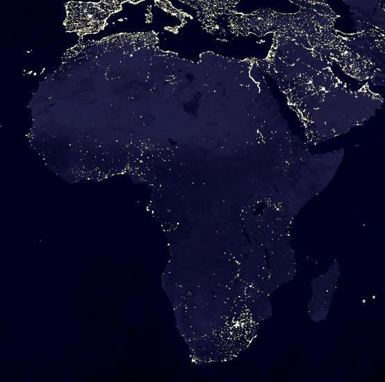
3 HAKUNA MATAA: No light
4 A number of features from 2008: Production: About 1 Toe/yr per capita, 51% exported, 47% consumed Consumption: 60% biomass, 34% Fossil fuels, 6% renewables Use in economic production 34% Low energy use & poor structure
5 Considering only the renewable energy sources, Africa s potential, in TWh (from IRENA, 2010) Wind power: 5,000 7,000 Solar Energy: 155, ,000 Geothermal energy: >125 Hydropower: 1,844 Bagasse: Of the non-intermittent sources, 9% of the hydro and 1% of the geothermal potentials have been developed by 2011
6 Sources Capacity, GW % Totals Africa has small power generation capacity. Only 20% Africans have electricity access (World average 86%) Average African consumes 124KWh/yr (World average 2,784) Africa needs to increase capacity 33-fold to serve all Africans The present system is too dependent on fossil fuels. Africa needs to use its abundant renewable energy sources: For additional generation capacity, and, To replace thermal generation
7 S. & N. Africa: 70% of Africa s generation capacity: Attributed to Coal in S. & natural gas in N & 739 KWh per capita in S & N Access to Electricity: >70% SSA Less privileged: Access 20%, per capita consumption 107 KWh/yr. Oil & gas in Gulf of Guinea area help Eastern Africa fares least: 15% access & 68 KWh/yr per capita consumption Each Eastern African could have a 60W light bulb to light for about 3 hours/day. There is no equity: the cities get 9/10 th of the electricity
8 1. Low African purchasing power. Economies grow 5%/yr. 7%/yr electricity demand growth promises more growth 2. High generation cost: Small power plants; Average hydroplant size= 46MW Develop large hydro, 2-6 GW: a 10-fold capacity increase halves the unit cost 3. Small markets can not accommodate large plant additions Interconnect national power supply systems to create larger regional markets &power trading 4. Large electricity consuming industries are in the cities, other power supply is unprofitable; Electricity is and essential social and economic infrastructure, do rural electrification schemes So there are the regional power pools which are addressing these issues.
9 Africa has a comparatively large potential Geothermal energy is: Indigenous Clean Renewable Cost competitive Suited to supplying base-load power, >90% load factor Versatile: a wide range of uses besides generation Agriculture, industry, tourism-recreation-health Usable in a wide range of economies of scale Capable of employing a range of technologies
 e.g. Karoo basins, Saharan Cretaceous sediments where fossil (Pleistocene) waters are produced in Libya (GMMR) & Tunisia for date palm farming.")
10 A. Crustal heat sources: A1. Radioactivity: Decay of U, Th, K accounts for 2/3 of the terrestrial heat flow. Mostly diffuse but also creates thermal springs in stable granitic basement, e.g. RSA, Tanzanian craton A2. Diagenesis: Heat is released when sediments are changed into sedimentary rocks (compaction & clay mineral dehydration are exothermic) e.g. Karoo basins, Saharan Cretaceous sediments where fossil (Pleistocene) waters are produced in Libya (GMMR) & Tunisia for date palm farming.
11 B. Mantle heat sources B1. Crust compression: Lithosphere subduction & melting engenders volcanism in Magreb Atlas mountains have shallow root due to delaminated lithosphere B2. Crust blistering: Thermal uplift w/o rifting: Ahagar, Tibesti, Jebel Merah, Comoros B3. Crust extension: B2a: Rifting & volcanism: Djibouti, Eritrea, Ethiopia, Kenya, Tanzania, Rwanda B2b: Failed rift & volcanism: Benue Trough & Cameroon Line B2c: Amagmatic rifting: Burundi, Malawi, Mozambique, Uganda


12 B. Mantle heat sources (contd) B3. Shear zones: Oblique impact between amalgamating continental blocks creates shear fault zones. In Africa, many have remained zones of crustal weakness and are periodically activated and host hydrothermal activity B3a TRM: involved in the opening Rifts since ~200 Ma along present SW L. Tanganyika basin & in East DRC B3b. MD: Most thermal springs in Zambia flow from this shear zone B3c. DLZL: Started as a suture zone between Antarctica and Central Gondwana between. Mozambique, Zambia, Zimbabwe

13 Most of the heat of the mantle that rises to the surface does so along rifts. Africa is especially favored in this respect As the mantle source is anomalously hot, large and relatively shallow
 The temperature anomaly in the asthenosphere imaged by geophysics (lines) and geochemistry (shaded).")

14 Plumes eise from Suprplume: Ahagar Tibesti J. Merah Afar E. African Comotos Core Asthenosphere (Lower mantle) The temperature anomaly in the asthenosphere imaged by geophysics (lines) and geochemistry (shaded). Thermal expansion resulted in the rise of the African Superplume which in turn induced the African Superswell, and the softening and breakup of the African crust by rifting & magmatism Lithosphere=Crust+Upper mantle The seismic tomogrphy image shows the African Superplume to rise to shallower depths northward and to impact on the crust beneath Afar (from Ritsema & Allen, EPSL 2003). Proximal impact is essential for advanced stages of rifting and magmatism. The EARS is nearly oceanic in the north but still incipiently continental in the south
15
Outcomes of the Workshop on the Geologic and Geothermal Development of the Western Branch of the Greater East African Rift System
 Outcomes of the Workshop on the Geologic and Geothermal Development of the Western Branch of the Greater East African Rift System Energy Ministerial Meeting 13 June 2016 AUC Headquarter Addis Ababa, Ethiopia
Outcomes of the Workshop on the Geologic and Geothermal Development of the Western Branch of the Greater East African Rift System
 Outcomes of the Workshop on the Geologic and Geothermal Development of the Western Branch of the Greater East African Rift System East Africa Donor Coordination Meeting 14 June 2016 AUC Headquarter Addis
GEOTHERMAL ENERGY EXPLORATION IN UGANDA, COUNTRY UPDATE 2006
 GEOTHERMAL ENERGY EXPLORATION IN UGANDA, COUNTRY UPDATE 2006 Godfrey Bahati Department of Geological Survey and Mines, P.O Box 9, Entebbe, Uganda First East African Rift Geothermal Conference-ARGeo ARGeo-C1
GeoPRISMS RIE Workshop 2010
 GeoPRISMS RIE Workshop 2010 Rift initiation - East Africa and Afar Derek Keir - University of Leeds GeoPRISMS RIE Workshop 2010 Rift initiation - East Africa and Afar Derek Keir - University of Leeds Conclusions
GEOTHERMAL EXPLORATION
 GEOTHERMAL EXPLORATION IN BURUNDI Country s location Burundi is a landlocked country in Central Africa, Its area is 27834 km², It is boarded with RDC in the West, Rwanda in the North and Tanzania in the
Topics: The Layers of the Earth and its Formation Sources of Heat Volcanos and Earthquakes Rock Cycle Rock Types Carbon Tax
 Topics: The Layers of the Earth and its Formation Sources of Heat Volcanos and Earthquakes Rock Cycle Rock Types Carbon Tax Essay Question on Carbon Tax 1. Drilling 2. Volcanic Activity 3. Laboratory experiments
Annað veldi ehf. Geothermal Provinces of Kenya
 Annað veldi ehf Geothermal Provinces of Kenya David Köndgen and Skuli Johannsson September 29, 2009 OUTLINE Overview Geology of Kenya Excursus: The Wilson Cycle How do rifts form? The world of Platetectonics
Global Tectonics. Kearey, Philip. Table of Contents ISBN-13: Historical perspective. 2. The interior of the Earth.
 Global Tectonics Kearey, Philip ISBN-13: 9781405107778 Table of Contents Preface. Acknowledgments. 1. Historical perspective. 1.1 Continental drift. 1.2 Sea floor spreading and the birth of plate tectonics.
Country s location
 GEOTHERMAL EXPLORATION IN BURUNDI Short course III on Exploration for Geothermal Resources organized by UNU-GTP and KenGen Naivasha, Kenya, 24th October - 17 November, 2008 Presented by HUREGE Déogratias
GEOTHERMAL ENERGY DEVELOPMENT IN UGANDA - A COUNTRY UPDATE 2016
 GEOTHERMAL ENERGY DEVELOPMENT IN UGANDA - A COUNTRY UPDATE 2016 Godfrey Bahati Ministry of Energy and Mineral Development, P.O Box 7072, Kampala, Uganda. Presented at the Sixth African Rift Geothermal
Earthquakes. Earthquakes are caused by a sudden release of energy
 Earthquakes Earthquakes are caused by a sudden release of energy The amount of energy released determines the magnitude of the earthquake Seismic waves carry the energy away from its origin Fig. 18.1 Origin
Strike-Slip Faults. ! Fault motion is parallel to the strike of the fault.
 Strike-Slip Faults! Fault motion is parallel to the strike of the fault.! Usually vertical, no hanging-wall/footwall blocks.! Classified by the relative sense of motion. " Right lateral opposite block
Copyright McGraw-Hill Education. All rights reserved. No reproduction or distribution without the prior written consent of McGraw-Hill Education
 Copyright McGraw-Hill Education. All rights reserved. No reproduction or distribution without the prior written consent of McGraw-Hill Education Tibetan Plateau and Himalaya -southern Asia 11.00.a VE 10X
Geologic Resources. Geologic Resources and Society. Geologic Resources and Society
 Geologic Resources Our entire society rests upon - and is dependent upon - our water, our land, our forests, and our minerals. How we use these resources influences our health, security, economy, and well-being.
Wilson cycle. 1. Intracontinental rift 2. From rifting to drifting
 Wilson cycle 1. Intracontinental rift 2. From rifting to drifting Stages of the Wilson Cycle Intracontinental Rifts 1. Contemporary examples (EAR, RGR, Baikal, Rhine graben) 2. Mechanical aspects. Characteristics
EDIMENTARY BASINS. What is a Sedimentary Basin? by Prof. Dr. Abbas Mansour
 EDIMENTARY BASINS What is a Sedimentary Basin? by Prof. Dr. Abbas Mansour WHAT IS A SEDIMENTARY BASIN? A low area on the Earth s surface relative to surroundings e.g. deep ocean basin (5-10 km deep) e.g.
Topic 12: Dynamic Earth Pracatice
 Name: Topic 12: Dynamic Earth Pracatice 1. Earth s outer core is best inferred to be A) liquid, with an average density of approximately 4 g/cm 3 B) liquid, with an average density of approximately 11
Application of Transient Electromagnetics for the Investigation of a Geothermal Site in Tanzania
 Application of Transient Electromagnetics for the Investigation of a Geothermal Site in Tanzania Gerlinde Schaumann, Federal Institute for Geosciences and Natural Resources (BGR), Stilleweg 2, 30655 Hannover,
Ore Deposits and Mantle Plumes
 Ore Deposits and Mantle Plumes by Franco Pirajno Geological Survey of Western Australia, Perth, Australia KLUWER ACADEMIC PUBLISHERS DORDRECHT / BOSTON / LONDON CONTENTS PREFACE ACKNOWLEDGEMENTS INTRODUCTION
Making a Mental Map of the Region
 Africa Preview Making a Mental Map of the Region Draw an outline map of Africa on the next page or on a separate sheet of paper. Add a compass rose to your map, showing where north, south, east, and west
10/11/2010. Acceleration due to gravity, a. Bulk Properties Mass = 6 x kg Diameter = 12,756 km Density = 5515 kg/m 3 (mix of rock and iron)
") Acceleration due to gravity, a Bulk Properties Mass = 6 x 10 24 kg Diameter = 12,756 km Density = 5515 kg/m 3 (mix of rock and iron) Escape Velocity, v e Albedo Amount of sunlight reflected back into space
Acceleration due to gravity, a Bulk Properties Mass = 6 x 10 24 kg Diameter = 12,756 km Density = 5515 kg/m 3 (mix of rock and iron) Escape Velocity, v e Albedo Amount of sunlight reflected back into space
Chapter 02 The Sea Floor
 Chapter 02 The Sea Floor Multiple Choice Questions 1. One of the following is not one of the world's major ocean basins: A. Atlantic Ocean B. Arctic Ocean C. Indian Ocean D. Antarctic Ocean E. Pacific
Important information from Chapter 1
 Important information from Chapter 1 Distinguish between: Natural hazard // Disaster // Catastrophe What role does human population play in these categories? Know how to read a Hazard Map, such as Figure
PHYSICAL GEOLOGY AND THE ENVIRONMENT (2 ND CANADIAN EDITION)
") Chapter 2: Plate Tectonics Chapter Summary: Plate tectonics is a theory that suggests Earth's surface is divided into several large plates that change position and size. Intense geologic activity occurs
Chapter 2: Plate Tectonics Chapter Summary: Plate tectonics is a theory that suggests Earth's surface is divided into several large plates that change position and size. Intense geologic activity occurs
Composition of the earth, Geologic Time, and Plate Tectonics
 Composition of the earth, Geologic Time, and Plate Tectonics Layers of the earth Chemical vs. Mechanical Chemical : Mechanical: 1) Core: Ni and Fe 2) Mantle: Mostly Peridotite 3) Crust: Many different
Continental Margin Geology of Korea : Review and constraints on the opening of the East Sea (Japan Sea)
") Continental Margin Geology of Korea : Review and constraints on the opening of the East Sea (Japan Sea) Han-Joon Kim Marine Satellite & Observation Tech. Korea Ocean Research and Development Institute
Continental Margin Geology of Korea : Review and constraints on the opening of the East Sea (Japan Sea) Han-Joon Kim Marine Satellite & Observation Tech. Korea Ocean Research and Development Institute
A) B) C) D) 4. Which diagram below best represents the pattern of magnetic orientation in the seafloor on the west (left) side of the ocean ridge?
 B) C) D) 4. Which diagram below best represents the pattern of magnetic orientation in the seafloor on the west (left) side of the ocean ridge?") 1. Crustal formation, which may cause the widening of an ocean, is most likely occurring at the boundary between the A) African Plate and the Eurasian Plate B) Pacific Plate and the Philippine Plate C)
1. Crustal formation, which may cause the widening of an ocean, is most likely occurring at the boundary between the A) African Plate and the Eurasian Plate B) Pacific Plate and the Philippine Plate C)
Lecture 24: Convergent boundaries November 22, 2006
 Lecture 24: Convergent boundaries November 22, 2006 Convergent boundaries are characterized by consumption of oceaninc crust in subduction zones, with attendant arc volcanism, metamorphism and uplift.
Topic 5: The Dynamic Crust (workbook p ) Evidence that Earth s crust has shifted and changed in both the past and the present is shown by:
 Evidence that Earth s crust has shifted and changed in both the past and the present is shown by:") Topic 5: The Dynamic Crust (workbook p. 65-85) Evidence that Earth s crust has shifted and changed in both the past and the present is shown by: --sedimentary horizontal rock layers (strata) are found
Topic 5: The Dynamic Crust (workbook p. 65-85) Evidence that Earth s crust has shifted and changed in both the past and the present is shown by: --sedimentary horizontal rock layers (strata) are found
EAST AFRICAN RIFT SYSTEM - AN OVERVIEW
 Presented at Short Course V on Exploration for Geothermal Resources, organized by UNU-GTP, GDC and KenGen, at Lake Bogoria and Lake Naivasha, Kenya, Oct. 29 Nov. 19, 2010. GEOTHERMAL TRAINING PROGRAMME
12. The diagram below shows the collision of an oceanic plate and a continental plate.
 Review 1. Base your answer to the following question on the cross section below, which shows the boundary between two lithospheric plates. Point X is a location in the continental lithosphere. The depth
. Slide 1. Geological Survey of Ethiopia, P.O.Box 2302, Addis Ababa, Ethiopia
 The electrical resistivity structure of the Southern Main Ethiopian Rift (around the Lake Abaya geothermal prospect) revealed by magneto-telluric telluric imaging Mohammednur Desissa and Yohanes Lema Geological
Welcome to GEO 101 Introduction to Geology
 Welcome to GEO 101 Introduction to Geology so what is Geology? not just rocks! Geology is... study of Earth and planetary bodies processes responsible for formation processes that modify all areas of geology
CH2356 Energy Engineering Geothermal Energy. Dr. M. Subramanian
 CH2356 Energy Engineering Geothermal Energy Dr. M. Subramanian Associate Professor Department of Chemical Engineering Sri Sivasubramaniya Nadar College of Engineering Kalavakkam 603 110, Kanchipuram(Dist)
Plate Tectonics Practice Test
 Plate Tectonics Practice Test 1. What is the main idea Alfred Wegner proposed in the Theory of Continental Drift that he published in 1915? a. The continents float on a liquid layer that allows them to
Earth Movement and Resultant Landforms
 Earth Movement and Resultant Landforms Structure of the Earth Lithosphere : earth s crust Asthenosphere : upper mantle zone where material is near its melting point & acts almost like liquid (appprox.
Plate Tectonics. entirely rock both and rock
 Plate Tectonics I. Tectonics A. Tectonic Forces are forces generated from within Earth causing rock to become. B. 1. The study of the origin and arrangement of Earth surface including mountain belts, continents,
Structure of the Earth
 Structure of the Earth Compositional (Chemical) Layers Crust: Low density Moho: Density boundary between crust and mantle Mantle: Higher density High in Magnesium (Mg) and Iron (Fe) Core: High in Nickel
D) outer core B) 1300 C A) rigid mantle A) 2000 C B) density, temperature, and pressure increase D) stiffer mantle C) outer core
 outer core B) 1300 C A) rigid mantle A) 2000 C B) density, temperature, and pressure increase D) stiffer mantle C) outer core") 1. In which area of Earth's interior is the pressure most likely to be 2.5 million atmospheres? A) asthenosphere B) stiffer mantle C) inner core D) outer core Base your answers to questions 2 and 3 on
1. In which area of Earth's interior is the pressure most likely to be 2.5 million atmospheres? A) asthenosphere B) stiffer mantle C) inner core D) outer core Base your answers to questions 2 and 3 on
Crustal Boundaries. As they move across the asthenosphere and form plate boundaries they interact in various ways. Convergent Transform Divergent
 Name: Date: Period: Plate Tectonics The Physical Setting: Earth Science CLASS NOTES Tectonic plates are constantly moving and interacting As they move across the asthenosphere and form plate boundaries
SEDIMENTARY BASINS Red Sea Coast of Egypt. by Prof. Dr. Abbas Mansour
 SEDIMENTARY BASINS Red Sea Coast of Egypt by Prof. Dr. Abbas Mansour Sedimentary basins Sedimentary basins are, in a very broad sense, all those areas in which sediments can accumulate to considerable
Continental Drift. & Plate Tectonics
 Continental Drift & Plate Tectonics Alfred Wegener, a German scientist, proposed the hypothesis of CONTINENTAL DRIFT, in 1912. Hypothesis stated: All Earth s continents were once a single landmass (Pangaea)
AN OVERVIEW OF THE GEOTHERMAL POTENTIAL OF PAPUA NEW GUINEA
 AN OVERVIEW OF THE GEOTHERMAL POTENTIAL OF PAPUA NEW GUINEA Nathan Mosusu Mineral Resources Authority P.O. Box 1906 Port Moresby, Papua New Guinea IRENA Consultative Workshop on Renewable Energy Developments
Earth and Space Science Semester 2 Exam Review. Part 1. - Convection currents circulate in the Asthenosphere located in the Upper Mantle.
 Earth and Space Science 2015 Semester 2 Exam Review Part 1 Convection -A form of heat transfer. - Convection currents circulate in the Asthenosphere located in the Upper Mantle. - Source of heat is from
Tectonics. Planets, Moons & Rings 9/11/13 movements of the planet s crust
 Tectonics Planets, Moons & Rings 9/11/13 movements of the planet s crust Planetary History Planets formed HOT Denser materials fall to center Planet cools by conduction, convection, radiation to space
10. Paleomagnetism and Polar Wandering Curves.
 Map of ocean floor Evidence in Support of the Theory of Plate Tectonics 10. Paleomagnetism and Polar Wandering Curves. The Earth's magnetic field behaves as if there were a bar magnet in the center of
USU 1360 TECTONICS / PROCESSES
 USU 1360 TECTONICS / PROCESSES Observe the world map and each enlargement Pacific Northwest Tibet South America Japan 03.00.a1 South Atlantic Arabian Peninsula Observe features near the Pacific Northwest
The continental lithosphere
 Simplicity to complexity: The continental lithosphere Reading: Fowler p350-377 Sampling techniques Seismic refraction Bulk crustal properties, thickness velocity profiles Seismic reflection To image specific
BELLRINGER How close a group of measurements are to each other is called. 1. estimation 2. accuracy 3. precision. 0% 0% 0% 0% 4.
 BELLRINGER How close a group of measurements are to each other is called 1. estimation 2. accuracy 3. precision 0% 0% 0% 0% 4. percent error estimation accuracy precision percent error Inside Earth Chapter
Plate Tectonics. A. Continental Drift Theory 1. Early development 2. Alfred Wegener s mechanism
 Plate Tectonics A. Continental Drift Theory 1. Early development 2. Alfred Wegener s mechanism B. Seafloor Spreading 1. Earthquakes and volcanoes 2. Seafloor maps and dates 3. Continental drift revisited
Before Plate Tectonics: Theory of Continental Drift
 Before Plate Tectonics: Theory of Continental Drift Predecessor to modern plate tectonics Shape and fit of the continents was the initial evidence Snider-Pelligrini (1858) Taylor (1908) Wegner (1915) Fig.
LIGO sees binary neutron star merger on August 17, 2017
 LIGO sees binary neutron star merger on August 17, 2017 Laser Interferometer Gravitational-Wave Observatory (LIGO) Laser Interferometer Gravitational-Wave Observatory (LIGO) Multi-Messenger Astronomy This
Structure of the Earth and the Origin of Magmas
 Page 1 of 12 EENS 2120 Petrology Tulane University Prof. Stephen A. Nelson Structure of the Earth and the Origin of Magmas This document last updated on 23-Jan-2015 Magmas do not form everywhere beneath
Introduction To Plate Tectonics Evolution. (Continents, Ocean Basins, Mountains and Continental Margins)
") Introduction To Plate Tectonics Evolution (Continents, Ocean Basins, Mountains and Continental Margins) Geo 386 (Arabian Shield Course) Dr. Bassam A. A. Abuamarah Mohanna G E O 3 8 6 A R A B I A N G E
Introduction To Plate Tectonics Evolution (Continents, Ocean Basins, Mountains and Continental Margins) Geo 386 (Arabian Shield Course) Dr. Bassam A. A. Abuamarah Mohanna G E O 3 8 6 A R A B I A N G E
Plate Tectonics Tutoiral. Questions. Teacher: Mrs. Zimmerman. Plate Tectonics and Mountains Practice Test
 Teacher: Mrs. Zimmerman Print Close Plate Tectonics and Mountains Practice Test Plate Tectonics Tutoiral URL: http://www.hartrao.ac.za/geodesy/tectonics.html Questions 1. Fossils of organisms that lived
September 14, SWBAT explain how divergent boundaries shape Earth s surface.
 September 14, 2016 Aims: SWBAT explain how divergent boundaries shape Earth s surface. Agenda 1. Do Now 2. Class Notes 3. Guided Practice 4. Independent Practice 5. Practicing our AIMS: Homework: EI.11
Theory of Continental Drift
 Plate Tectonics Theory of Continental Drift Alfred Wegener suggested that continents had once been part of a supercontinent named Pangaea, that later broke up. The pieces moved apart over millions of years
Practice Questions: Plate Tectonics
 Practice Questions: Plate Tectonics 1. Base your answer to the following question on The block diagram below shows the boundary between two tectonic plates. Which type of plate boundary is shown? A) divergent
An Introduction of Aleutian Subduction Zone. Chuanmao Yang, Hong Yang, Meng Zhang, Wenzhong Wang 2016/04/29
 An Introduction of Aleutian Subduction Zone Chuanmao Yang, Hong Yang, Meng Zhang, Wenzhong Wang 2016/04/29 Outline General Introduction Formation history Structure from seismic study geochemical features
Advanced Workshop on Evaluating, Monitoring and Communicating Volcanic and Seismic Hazards in East Africa.
 2053-8 Advanced Workshop on Evaluating, Monitoring and Communicating Volcanic and Seismic Hazards in East Africa 17-28 August 2009 Seismicity of the East African Rift Atalay Ayele W. Addis Ababa University
THE ROLE OF SEAMIC IN SUSTAINABLE MINERAL RESOURCES DEVELOPMENT IN AFRICA
 THE ROLE OF SEAMIC IN SUSTAINABLE MINERAL RESOURCES DEVELOPMENT IN AFRICA Ketema Tadesse Director General-SEAMIC Dar es Salaam, Tanzania August 11, 2009 SEAMIC BACKGROUND SEAMIC was established in 1977
Dynamic Crust Practice
 1. Base your answer to the following question on the cross section below and on your knowledge of Earth science. The cross section represents the distance and age of ocean-floor bedrock found on both sides
PLATE TECTONICS. Continental Drift. Continental Drift. Continental Drift. Continental Drift- Wegener s Evidence
 Continental Drift PLATE TECTONICS E.B. Taylor (1910) and Alfred Wegener (1915) published on Continental Drift. Continental Drift Wegener s evidence 1. Fit of the Continents 2. Fossil Evidence 3. Rock Type
Chapter 8: The Dynamic Planet
 Chapter 8: The Dynamic Planet I. The Pace of Change A. The Geologic Time Scale II. Earth s Structure and Internal Energy A. The Earth s Core B. The Earth s Mantle C. The Earth s Crust III. The Geologic
GENERAL GEOLOGY Fall Chapter 18: The Sea Floor. Partial Examination IV Study Guide Dr. Glen S. Mattioli
 GENERAL GEOLOGY 1113-005 Fall 2008 Partial Examination IV Study Guide Dr. Glen S. Mattioli Note that these are NOT questions, but rather are a list of topics that we have covered either in class or are
Science 10 PROVINCIAL EXAM STUDY BOOKLET. Unit 4. Earth Science
 Science 10 PROVNCAL EXAM STUDY BOOKLET Unit 4 Earth Science Student nstructions 1. Ensure that you have blank paper and a Data Booklet. 2. Record all answers on a separate piece of paper. 3. Answer keys
CURRENT STATUS AND THE WAY FORWARD FOR GEOTHERMAL EXPLORATION IN BURUNDI
 Proceedings, 6 th African Rift Geothermal Conference Addis Ababa, Ethiopia, 2 nd 4 th November 2016 CURRENT STATUS AND THE WAY FORWARD FOR GEOTHERMAL EXPLORATION IN BURUNDI Oswald, Bujumbura, Burundi ndagijeoswalde@yahoo.fr
SECOND AFRICAN RIFT GEOTHERMAL CONFERENCE 24 th -28 th NOVEMBER, 2008 ENTEBBE, UGANDA. Ministry of Infrastructure P.O. Box:24, Kigali Rwanda
 SECOND AFRICAN RIFT GEOTHERMAL CONFERENCE 24 th -28 th NOVEMBER, 2008 ENTEBBE, UGANDA Ministry of Infrastructure P.O. Box:24, Kigali Rwanda Uwera RUTAGARAMA In charge of geothermal development Introduction
Chapter. Graphics by Tasa Graphic Arts. Inc.
 Earth Chapter Plate Science 9 Tectonics Graphics by Tasa Graphic Arts. Inc. 1 I. Earth s surface is made up of lithospheric plates. A. Lithospheric plates are composed of the crust and part of the upper
6. In the diagram below, letters A and B represent locations near the edge of a continent.
 1. Base your answer to the following question on the cross section below and on your knowledge of Earth science. The cross section represents the distance and age of ocean-floor bedrock found on both sides
Questions and Topics
 Plate Tectonics and Continental Drift Questions and Topics 1. What are the theories of Plate Tectonics and Continental Drift? 2. What is the evidence that Continents move? 3. What are the forces that
Mesozoic Earth History
 Mesozoic Earth History The Mesozoic Era 251-66 MYA Breakup of Pangea Changes in air and oceanic currents Evolution of new terrestrial and marine life Opening of the Atlantic Ocean Basin Rocky Mountains
RAYMOND SIEVER Harvard University
 E A R T H FOURTH EDITION FRANK PRESS National Academy of Sciences RAYMOND SIEVER Harvard University W. H. Freeman and Company New York Preface xiii Acknowledgments xviii PART I PROLOGUE CHAPTER 1 HISTORY
Why does the Earth have volcanoes? Why is there Earthquakes?
 Why does the Earth have volcanoes? Why is there Earthquakes? Turn to your neighbor and review: How and when did the Earth form? How old are the first traces of life on Earth? Logical? * 1.5Ga (1 st multicellular
Chapter 2: Plate Tectonics: A Unifying Theory
 Chapter 2: Plate Tectonics: A Unifying Theory Chapter Outline 2.1 Introduction 2.2 Early Ideas About Continental Drift 2.3 What Is the Evidence for Continental Drift? 2.4 Features of the Seafloor 2.5 Earth
Heat (& Mass) Transfer. conceptual models of heat transfer. large scale controls on fluid movement. distribution of vapor-saturated conditions
 Transfer. conceptual models of heat transfer. large scale controls on fluid movement. distribution of vapor-saturated conditions") Heat (& Mass) Transfer conceptual models of heat transfer temperature-pressure gradients large scale controls on fluid movement distribution of vapor-saturated conditions fluid flow paths surface manifestations
Heat (& Mass) Transfer conceptual models of heat transfer temperature-pressure gradients large scale controls on fluid movement distribution of vapor-saturated conditions fluid flow paths surface manifestations
Understanding riverine wetland-catchment processes using remote sensing data and modelling
 Understanding riverine wetland-catchment processes using remote sensing data and modelling Yunqing Xuan (UNESCO-IHE, NL) Didier Haguma (KIST, Rwanda) William Niyonzima (UNESCO-IHE, NL) Ann van Griensven
1. CLIMATIC AND ENVIRONMENTAL CONDITIONS OVER AFRICA. 1.1 Inter-Tropical Discontinuity (ITD)
") African Centre of Meteorological Application for Development Centre Africain pour les Applications de la Météorologie au Développement OCTOBER 2011 HIGHLIGHT: Cholera, Acute Water Diarrhoea, Yellow fever,
African Centre of Meteorological Application for Development Centre Africain pour les Applications de la Météorologie au Développement OCTOBER 2011 HIGHLIGHT: Cholera, Acute Water Diarrhoea, Yellow fever,
Rocks and the Rock Cycle. Banded Iron Formation
 Rocks and the Rock Cycle Banded Iron Formation Rocks Big rocks into pebbles, Pebbles into sand. I really hold a million, million Rocks here in my hand. Florence Parry Heide How do rocks change? How are
Plate Tectonics. Essentials of Geology, 11 th edition Chapter 15
 1 Plate Tectonics Essentials of Geology, 11 th edition Chapter 15 2 3 4 5 6 7 8 9 10 11 12 13 14 15 Plate Tectonics: summary in haiku form Alfred Wegener gave us Continental Drift. Fifty years later...
Plate Tectonics. Earth has distinctive layers - Like an onion
 Plate Tectonics Earth has distinctive layers - Like an onion Earth s Interior Core: Metallic (Iron, Nickel) Inner (hot, solid, dense, Iron, Nickel) Outer (cooler, liquid, less dense) Crust (outermost layer):
1. I can describe evidence for continental drift theory (e.g., fossil evidence, mountain belts, paleoglaciation)
") Science 10 Review Earth Science Vocabulary asthenosphere continental drift theory converging plates diverging plates earthquakes epicentre fault hot spot inner core lithosphere mantle mantle convection
Science 10 Review Earth Science Vocabulary asthenosphere continental drift theory converging plates diverging plates earthquakes epicentre fault hot spot inner core lithosphere mantle mantle convection
Sir Francis Bacon, 1620, noted that the continental coasts on opposites sides of the Atlantic fit together like puzzle pieces.
 Plate Tectonics Sir Francis Bacon, 1620, noted that the continental coasts on opposites sides of the Atlantic fit together like puzzle pieces. Could North and South America once have been joined to Europe
3. PLATE TECTONICS LAST NAME (ALL IN CAPS): FIRST NAME: PLATES
: FIRST NAME: PLATES") LAST NAME (ALL IN CAPS): FIRST NAME: PLATES 3. PLATE TECTONICS The outer layers of the Earth are divided into the lithosphere and asthenosphere. The division is based on differences in mechanical properties
LAST NAME (ALL IN CAPS): FIRST NAME: PLATES 3. PLATE TECTONICS The outer layers of the Earth are divided into the lithosphere and asthenosphere. The division is based on differences in mechanical properties
Earth as a planet: Interior and Surface layers
 Earth as a planet: Interior and Surface layers Bibliographic material: Langmuir & Broecker (2012) How to build a habitable planet Internal structure of the Earth: Observational techniques Seismology Analysis
Unit Maps: Middle School Earth Science
 Structure of Earth Earth and space. The student understands the structure of Earth and the rock cycle. The student will explain what it means to say that God created the world and all matter out of nothing
D D Matyanga Mineral Economist and Technical Advisor
 D D Matyanga Mineral Economist and Technical Advisor } Coal resources in Zimbabwe } Coal production historical perspective } Future of coal production } Significance of coal to the Economy Employment Exports
Full file at
 Chapter 2 PLATE TECTONICS AND PHYSICAL HAZARDS MULTIPLE-CHOICE QUESTIONS 1. What direction is the Pacific Plate currently moving, based on the chain of Hawaiian Islands with only the easternmost island
Earth Systems Science Chapter 7. Earth Systems Science Chapter 7 11/11/2010. Seismology: study of earthquakes and related phenomena
 Earth Systems Science Chapter 7 I. Structure of the Earth II. Plate Tectonics The solid part of the earth system includes processes, just like the atmosphere and oceans. However, the time scales for processes
Physical and Chemical Properties of Matter
 Physical and Chemical Properties of Matter 5(D) identify the formation of a new substance by using the evidence of a possible chemical change such as production of a gas, change in temperature, production
Continental Alkaline Magmatism. The East African Rift
 Announcements No lecture on Friday Lab final begins at 1 PM Today s agenda: Lecture/Demo Go through field trip pics Call for pizza Lab review Lecture Review Make poster Continental Alkaline Magmatism.
Nebular Hypothesis (Kant, Laplace 1796) - Earth and the other bodies of our solar system (Sun, moons, etc.) formed from a vast cloud of dust and
 - Earth and the other bodies of our solar system (Sun, moons, etc.) formed from a vast cloud of dust and") Plate Tectonics Origin of Universe Big Bang model (Hubble, 1929) - The universe began with an explosive e expansion of matter, which later became what we know as stars, planets, moons, etc. This event
Plate Tectonics Origin of Universe Big Bang model (Hubble, 1929) - The universe began with an explosive e expansion of matter, which later became what we know as stars, planets, moons, etc. This event
EASTERN RIFT STRUCTURAL GEOLOGY TECTONICS, VOLCANOLOGY AND GEOTHERMAL
 Presented at SDG Short Course I on Exploration and Development of Geothermal Resources, organized by UNU-GTP, GDC and KenGen, at Lake Bogoria and Lake Naivasha, Kenya, Nov. 10-31, 2016. Kenya Electricity
STRUCTURAL CONTROL OF RUNGWE VOLCANIC PROVINCE AND ITS IMPLICATION ON GEOTHERMAL SYSTEM
 Proceedings, 6 th African Rift Geothermal Conference Addis Ababa, Ethiopia, 2 nd 4 th November 2016 STRUCTURAL CONTROL OF RUNGWE VOLCANIC PROVINCE AND ITS IMPLICATION ON GEOTHERMAL SYSTEM Albano Mahecha¹,
The Structure of the Earth and Plate Tectonics
 The Structure of the Earth and Plate Tectonics Structure of the Earth The Earth is made up of 4 main layers: Inner Core Outer Core Mantle Crust Crust Mantle Outer core Inner core The Crust This is where
TERRESTRIAL HEAT FLOW: Why do we care? What do we (think we) know? What don t we know (and welcome help with)?
 know? What don t we know (and welcome help with)?") TERRESTRIAL HEAT FLOW: Why do we care? What do we (think we) know? What don t we know (and welcome help with)? Carol Stein University of Illinois at Chicago Seth Stein Northwestern University ~20,000 sites
TERRESTRIAL HEAT FLOW: Why do we care? What do we (think we) know? What don t we know (and welcome help with)? Carol Stein University of Illinois at Chicago Seth Stein Northwestern University ~20,000 sites
GO ON. Directions: Use the diagram below to answer question 1.
 d i a g n o s t i c t e s t : e a r t h a n d s p a c e s c i e n c e question 1. 1. What is the correct order (starting from the surface) of Earth s layers? A crust, outer core, inner core, mantle B mantle,
Earth s Continents and Seafloors. GEOL100 Physical Geology Ray Rector - Instructor
 Earth s Continents and Seafloors GEOL100 Physical Geology Ray Rector - Instructor OCEAN BASINS and CONTINENTAL PLATFORMS Key Concepts I. Earth s rocky surface covered by of two types of crust Dense, thin,
Mountains are then built by deforming crust: Deformation & Mountain Building. Mountains form where stresses are high!
 Deformation & Mountain Building Where are mountains located? Deformation and Folding Mountain building Mountains form where stresses are high! Mountains form at all three types of plate boundaries where
GEOLOGY. What is geology?
 GEOLOGY What is geology? It is essentially the study of the earth and it s dynamic processes. Features and processes of rocks, the earth s interior and surface. Structure of the Earth Made up of three