The Geomorphology of the Pig Point Site (18AN50) Landform Development, Climate Change, and Long-Term Human Occupation
|
|
|
- Blanche Hood
- 5 years ago
- Views:
Transcription


1 The Geomorphology of the Pig Point Site (18AN50) Landform Development, Climate Change, and Long-Term Human Occupation D O N M U L L I S T E T R A T EC H S T E P H A N I E S P E R L I N G A N N E A R U N D E L C O U N T Y LO S T TO W N S P R O J EC T D R. F R A N K V E N TO - C L A R I O N P E N N S Y LVA N I A U N I V E R S I T Y D R. A L LU C K E N BAC H A N N E A R U N D E L C O U N T Y LO S T TO W N S P R OJ EC T J A M E S M A R I N E, E D D O L A N T E T R A T EC H 1


2 Site Background Promontory Bluff Above 500 Year Floodplain Jug Bay Western Shore Uplands Source: Dr. Al Luckenbach Anne Arundel County Lost Towns Project Patuxent River, Maryland 2
")
3 Site Background Site initially recognized in 2008, with field excavations 2009 to ft square units documented 365 features, 630,000 artifacts, 30 c-14 dates which spanned nearly 10,000 years Three distinct areas excavated: Lower Block Upper Block North Block Site Map with Lidar-Derived DEM (ESRI) 3

4 Site Background Lower Block Feasting Area Contained Woodland period midden Stratified in situ Early, Middle, and Late Archaic cultural deposits Cultural deposits extended to over 6 ft (2 m) below grade Upper Block Habitation Area Intact stratigraphy from Late Woodland to Early Archaic Thousands post-holes marking outlines of wigwams North Block Ritual Area Rare Adena-influenced mortuary pits North Block Ritual Area Upper Block Habitation Area Lower Block Feasting Area 4
5 Projectile Points Over 500 Complete No Major Data Gaps 5

6 Lower Block Depth (over 6 ft of Cultural Deposits) Why? Early Archaic Kirk Point Source: Dr. Al Luckenbach - AA County Lost Towns Project Need for Additional Scientific Disciplines in Geology and Geomorphology 6
7 Geomorphological Investigation Development of a Site Conceptual Model Desktop Study (Previous Research) Developed Draft Geologic X-Sections Visual Observations via Site Visits of Open Excavations Hand Auger Soil Sampling (Multiple) Digital Photography of Sediments 3D Stratigraphic Modeling Soil Survey and Soil Profile Analysis ESRI GIS Mapping (LIDAR) Coulter-Counter Grain Size Analysis Multiple Lines of Evidence 7

8 Geology Patuxent River Valley Terrace Deposits Mapped as Pleistocene Interbedded sand and gravel Lesser amounts of Silt/Clay Quartzose gravel typically concentrated in lower portion Cobbles and boulders of mafic rock Limonite conglomerate Glauconitic Sands Source: MGS Anne Arundel County Geologic Map Desktop Study 8
 Markewich, Litwin, Wysocki, Pavich")
 - NW to SE Trending Ridge lines Desktop")
9 Site Location Source: Synthesis on Quaternary aeolian research (2015) Markewich, Litwin, Wysocki, Pavich Dune Fields - Infilled parabolic - Medium Sands ( mm) - NW to SE Trending Ridge lines Desktop Study 9

10 LIDAR maps confirmed presence of parabolic topographic relief and NW to SE ridge lines Regional Map Source Bordering Dune Aeolian Topography ESRI GIS Mapping - LIDAR 10
 Former Sand")
 Infilled")
 Relic Aeolian Conditions Determined")
11 Aeolian Sand Soils in Pig Point and DORR Archeological Areas (NRCS) Former Sand Quarry Location DORR (18AN19) Hand Auger Locations Pig Point (18AN50) Infilled Parabolic Dune Source: Ivester and Leigh (2003) Relic Aeolian Conditions Determined by Soil Survey Data 11
 Block X Block Early Archaic")
12 Development of Geologic X-Sections (Local Area) B Stream Channel SC1 60 Groundwater Springs/Seeps 0 20 X NB 40 JC X X X UB X LB B Elevation of Ground Surface (Ft MSL) 40 MSL 35 MSL 30 MSL 25 MSL 20 MSL 15 MSL 10 MSL 5 MSL 0 MSL 0 ft Mantle of Relic Aeolian Sands Lower Upper North B B Patuxent River Groundwater Springs/Seeps Slope Wash (Holocene) Block X Block Early Archaic Artifacts and features X Block Fluvial Terrace Deposits (Gravelly Sand) Marine Clay (Eocene) Bt (Argillic Unit) 150 ft 300 ft 450 ft 600 ft 750 ft 900 ft 1,050 ft 1,200 ft 1,350 ft


13 In Field - Data Collection Data collection: Soil sampling from open excavations Hand auger sampling at bottom of archeological units and in near-by strategic areas Data Collection Soil Sampling and Completion of Hand Augers 13

14 Typical Digital Photograph of Sediments Limonite? Glauconite Iron Stained Quartz Typical of Patuxent River Terrace Deposit Sediments Digital Photography of Sediments 14

15 Increased Variability of Gravel within Lower Block (Adjacent to Swale/Stream Bank) 3D Model of Gravel/Non Gravel Interface Potential Climate Change Events? 3D Stratigraphic Modeling (Site Specific) 15


16 Document multiple climate-driven erosional and depositional cycles Soil Profile Analysis Multiple A horizons, A/E transition, series BC horizons, C1/C2 fluvial gravel 16

17 Highest % in Medium Sand Fractions Higher % of VF and F Sand Higher % of C and VC Sands Coulter-Counter Grain Size Analysis 42 Samples 17
18 Mean Grain Size calculated from <2 mm truncated sample set Gravel in Sample Bag Possible changes during Scandic Time Period Pleistocene Terrace Deposit Sediments Evidence of Change in Geomorphological Conditions at Pleistocene/Holocene Contact (Younger Dryas?) Relic Late Pleistocene Aeolian Sediments Evidence of Hypsithermal Sediment Accumulation Changes? Coulter-Counter Grain Size Analysis Relic Aeolian vs Fluvial Coarse Gravel 18
 Early Holocene Landform Stabilization Sediment Accumulation Rates and Climate Change")
19 Increased Mass- Wasting during Pacific/Little Ice Age, Late Woodland, and Historic Periods Development of Anthropogenic Midden during Stable Sub- Atlantic/Scandic/Neo- Atlantic Early and Middle Woodland Periods Colluvial Over- Printing and Mass Wasting During Hypsithermal (5-7 ka) Early Holocene Landform Stabilization Sediment Accumulation Rates and Climate Change 19
20 Hypsithermal (5-7Ka) Scandic Disconformity (increased flood frequency and magnitude) Chesapeake Bay Stabilizes Possible Erosional Sequence Along Lower Slope of Swale Warmer and Dryer (decrease in vegetation allowing more erosion during rain events) C-14 (Avg 2-sigmas YBP) Sediment Accumulation Rates and Climate Change 20

21 Chesapeake Bay Stabilizes Hypsithermal (5-7Ka) Climate Change and Long Term Human Occupation 21
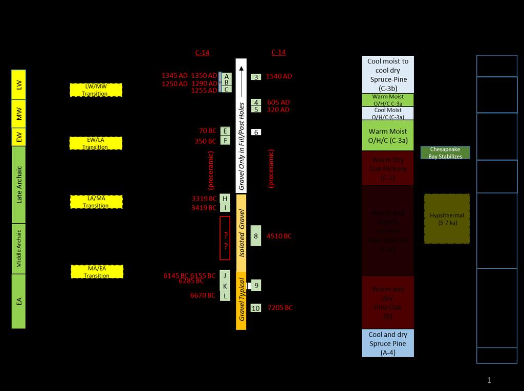

22 Summary Correlation Chart 22
23 Northwest Calvert Formation (Miocene Marine) Patuxent River Terrace Deposits (Alluvial) A Geomorphic Landform Development of Pig Point (Late Pleistocene) Active Source-Bordering Dunes Pig Point Patuxent River Terrace Deposits (Alluvial) Southeast Calvert Formation (Miocene -Marine) Nanjemoy Formation (Eocene- Marginal Shelf) Exposed Braid-Bars Prevailing Wind Direction Nanjemoy Formation (Eocene- Marginal Shelf) Marlboro Clay (Eocene Intertidal) Braid-plain Sediments (Patuxent River) Marlboro Clay (Eocene Intertidal) Aquia Formation (Paleocene Shallow Marine) Paleo River Valley Aquia Formation (Paleocene Shallow Marine) (a) Alluvial deposition of basal Pleistocene terrace sand and gravel deposits and Late Pleistocene deposition of active source-bordering aeolian dunes from braid-plain river sediments Geomorphic Landform Development 23
24 Northwest Calvert Formation (Miocene Marine) Patuxent River Terrace Deposits (Alluvial) B Geomorphic Landform Development of Pig Point (Late Pleistocene/Early Holocene) Period of Erosion and Active Slope Wash Relic Source-Bordering Dunes Pig Point Southeast Calvert Formation (Miocene -Marine) Patuxent River Terrace Deposits (Alluvial) Nanjemoy Formation (Eocene- Marginal Shelf) Exposed Braid-Bars Nanjemoy Formation (Eocene- Marginal Shelf) Marlboro Clay (Eocene Intertidal) Braid-plain Sediments (Patuxent River) Marlboro Clay (Eocene Intertidal) Aquia Formation (Paleocene Shallow Marine) Paleo River Valley Aquia Formation (Paleocene Shallow Marine) (b) Terrace scarp erosion during the warm, wet interstadial culminating in the cool and dry Younger Dryas Geomorphic Landform Development 24
25 Northwest Calvert Formation (Miocene Marine) Patuxent River Terrace Deposits (Alluvial) C Geomorphic Landform Development of Pig Point (Early and Middle Holocene) Patuxent River (Beginning of Holocene Silts and Meandering River) Continued Slope Wash and Mass Wasting Relic Source-Bordering Dunes Pig Point Patuxent River Terrace Deposits (Alluvial) Southeast Calvert Formation (Miocene -Marine) Nanjemoy Formation (Eocene- Marginal Shelf) Holocene Sands and Silts (Alluvial) Nanjemoy Formation (Eocene- Marginal Shelf) Marlboro Clay (Eocene Intertidal) Marlboro Clay (Eocene Intertidal) Aquia Formation (Paleocene Shallow Marine) Buried Braid-plain Sediments (Patuxent River) Paleo River Valley Aquia Formation (Paleocene Shallow Marine) (c) Increased erosion and colluvial over-printing (increased mass wasting) of up-gradient aeolian sands with enhanced activity in the Middle Archaic hypsithermal Geomorphic Landform Development 25
26 Northwest Calvert Formation (Miocene Marine) Patuxent River Terrace Deposits (Alluvial) Geomorphic Landform Development of Pig Point (Late Holocene to Present) D Patuxent River (Sediment Laden and Meandering) Cumulic A Horizon Develops Colluvial Slope Wash and Remnants of Source- Bordering Dunes Pig Point Patuxent River Terrace Deposits (Alluvial) Southeast Calvert Formation (Miocene -Marine) Nanjemoy Formation (Eocene- Marginal Shelf) Marlboro Clay (Eocene Intertidal) Holocene Sands and Silts (Alluvial) Perched Water Nanjemoy Formation (Eocene- Marginal Shelf) Marlboro Clay (Eocene Intertidal) Aquia Formation (Paleocene Shallow Marine) Paleo River Valley Braid-plain Sediments (Patuxent River) Aquia Formation (Paleocene Shallow Marine) (d) Landform stability and development of a cumulic A horizon with anthropogenic enrichment during the stable Sub Atlantic through Neo Atlantic (Early and Middle Woodland periods) and additional colluvial over-printing by accelerated mass wasting from the Little Ice Age through historic deforestation (Late Woodland and Historic periods) Special Thanks Stephanie Sperling Anne Arundel County Lost Towns Project Dr. Frank Vento - Clarion Pennsylvania University Dr. Al Luckenbach Anne Arundel County Lost Towns Project James marine, Ed Dolan Tetra tech Geomorphic Landform Development 26
Geology and New England Landscapes
 Geology and New England Landscapes Jim Turenne, CPSS USDA-NRCS Warwick, RI. http://nesoil.com Why Geology? Provides the big picture of site conditions. Major part of soil formation (parent material and
Laboratory Exercise #4 Geologic Surface Processes in Dry Lands
 Page - 1 Laboratory Exercise #4 Geologic Surface Processes in Dry Lands Section A Overview of Lands with Dry Climates The definition of a dry climate is tied to an understanding of the hydrologic cycle
Weathering, Erosion, Deposition, and Landscape Development
 Weathering, Erosion, Deposition, and Landscape Development I. Weathering - the breakdown of rocks into smaller particles, also called sediments, by natural processes. Weathering is further divided into
The Montauk Peninsula: Data and Preliminary Interpretations of the Ditch Plains Area Introduction
 The Montauk Peninsula: Data and Preliminary Interpretations of the Ditch Plains Area John A. Black GSI Patchogue, New York R.S. Welch Suffolk Community College Selden, New York Introduction Sirkin, (1982)
APPENDIX G GLOSSARY. Mn/DOT/WR-0200
 APPENDIX G GLOSSARY Mn/DOT/WR-0200 Alluvial - comprised of clay, silt, sand, gravel, and/or other detritus deposited by water. Usually refers to accretionary overbank, floodplain or levee deposits. Biomantling
Stream Classification
 Stream Classification Why Classify Streams? Communication Tool Describe Existing Conditions & Trends Describe Restoration Goals Research Tool Morphologic Stream Classification Systems Schumm (1977) Alluvial
Geologic Trips San Francisco and the Bay Area
 Excerpt from Geologic Trips San Francisco and the Bay Area by Ted Konigsmark ISBN 0-9661316-4-9 GeoPress All rights reserved. No part of this book may be reproduced without written permission in writing,
PolyMet NorthMet Project
 RS 26 Draft-01 December 8, 2005 RS26 Partridge River Level 1 Rosgen Geomorphic Survey Rosgen Classification Partridge River from Headwaters to Colby Lake Prepared for PolyMet NorthMet Project December
SUPPLEMENTAL MATERIAL
 SUPPLEMENTAL MATERIAL DESCRIPTIONS OF OTHER STRATIGRAPHIC SECTIONS Cherry Creek In its middle reaches, Cherry Creek meanders between three paired terraces within a narrow bedrock valley. The highest is
RIVERS, GROUNDWATER, AND GLACIERS
 RIVERS, GROUNDWATER, AND GLACIERS Delta A fan-shaped deposit that forms when a river flows into a quiet or large body of water, such as a lake, an ocean, or an inland sea. Alluvial Fan A sloping triangle
Depositional Environment
 Depositional Environment Sedimentary depositional environment describes the combination of physical, chemical and biological processes associated with the deposition of a particular type of sediment. Types
Figure 1 The map shows the top view of a meandering stream as it enters a lake. At which points along the stream are erosion and deposition dominant?
 1. In which type of climate does chemical weathering usually occur most rapidly? 1. hot and dry 3. cold and dry 2. hot and wet 4. cold and wet 2. Figure 1 The map shows the top view of a meandering stream
THE CROOKS GAP HOUSEPIT SITE AND OTHER NEARBY MID-HOLOCENE HOUSEPITS
 Volume 56(1 ), Spring 2012 The Wyoming Archaeologist THE CROOKS GAP HOUSEPIT SITE AND OTHER NEARBY MID-HOLOCENE HOUSEPITS by Craig S. Smith Marcia Peterson INTRODUCTION This article summarizes excavation
Objectives: Define Relative Age, Absolute Age
 S6E5. Students will investigate the scientific view of how the earth s surface is formed. c. Classify rocks by their process of formation. g. Describe how fossils show evidence of the changing surface
The Geology of Sebago Lake State Park
 Maine Geologic Facts and Localities September, 2002 43 55 17.46 N, 70 34 13.07 W Text by Robert Johnston, Department of Agriculture, Conservation & Forestry 1 Map by Robert Johnston Introduction Sebago
Starting at Rock Bottom: A Peculiar Central Texas PreClovis Culture
 Starting at Rock Bottom: A Peculiar Central Texas PreClovis Culture Background Brushy Creek grades, overall, west-northwest (WNW) to east-southeast (ESE) through the easternmost portions of the central
Permafrost-influenced Geomorphic Processes
 Section 4 Permafrost-influenced Geomorphic Processes Geomorphic processes vary greatly among ecoregions in northern Alaska, extending from the Beaufort Sea coast to the Brooks Range (Figure 4.1). Regional
27. Running Water I (p ; )
") 27. Running Water I (p. 424-436; 440-444) Hydrosphere How much of the Earth s surface is covered by water? Earth's water is collectively called the and is stored in a number of so-called as follows: 1.
27. Running Water I (p. 424-436; 440-444) Hydrosphere How much of the Earth s surface is covered by water? Earth's water is collectively called the and is stored in a number of so-called as follows: 1.
Rivers T. Perron
 1 Rivers T. Perron 12.001 After our discussions of large-scale topography, how we represent topography in maps, and how topography interacts with geologic structures, you should be frothing at the mouth
COASTAL QUATERNARY GEOLOGY MAPPING FOR NSW: EXAMPLES AND APPLICATIONS
 COASTAL QUATERNARY GEOLOGY MAPPING FOR NSW: EXAMPLES AND APPLICATIONS A Troedson Geological Survey of New South Wales Abstract Detailed geological mapping of the coastal plains of regional NSW was undertaken
4. The map below shows a meandering stream. Points A, B, C, and D represent locations along the stream bottom.
 1. Sediment is deposited as a river enters a lake because the A) velocity of the river decreases B) force of gravity decreases C) volume of water increases D) slope of the river increases 2. Which diagram
Page 1. Name:
 Name: 1) Which property would best distinguish sediment deposited by a river from sediment deposited by a glacier? thickness of sediment layers age of fossils found in the sediment mineral composition
Sediment and sedimentary rocks Sediment
 Sediment and sedimentary rocks Sediment From sediments to sedimentary rocks (transportation, deposition, preservation and lithification) Types of sedimentary rocks (clastic, chemical and organic) Sedimentary
Jim Turenne. Soils on Social Media
 Jim Turenne USDA-NRCS 60 Quaker Lane, Suite 46 Warwick, RI. 02886 401-822-8832 Jim.turenne@ri.usda.gov Soils on Social Media www.twitter.com/soilsne www.fb.com/soilsne www.nesoil.com U.S. Department of
2.2.7 Backbarrier flats
 FIGURE 24. VERTICAL PHOTOGRAPH SHOWING THE DEVELOPMENT OF SMALL PARABOLIC DUNES FROM BLOWOUTS IN A LARGE RELICT FOREDUNE NORTHWEST OF HUNTER'S CREEK. PHOTOGRAPH COURTESY OF CAR'T'ER HOLT HARVEY FORESTS
' International Institute for Land Reclamation and Improvement. 2 Groundwater Investigations. N.A. de Ridder'? 2.1 Introduction. 2.
 2 Groundwater Investigations N.A. de Ridder'? 2.1 Introduction Successful drainage depends largely on a proper diagnosis of the causes of the excess water. For this diagnosis, one must consider: climate,
1. Base your answer to the following question on the map below, which shows the generalized bedrock of a part of western New York State.
 1. Base your answer to the following question on the map below, which shows the generalized bedrock of a part of western New York State. 3. The table below describes the deposits that an observer saw while
 Page 1 of 9 Name: Base your answer to the question on the diagram below. The arrows show the direction in which sediment is being transported along the shoreline. A barrier beach has formed, creating a
 UNIT DESCRIPTIONS: Artificial Fill, Undocumented (Afu): Locally derived sandy silt and silty sand, locally with clay and varying amounts of gravel and man-made debris. Abundant concrete rubble, in places
Erosion and Deposition along Rivers and Seashores - Part 1: Modeling in the Classroom
 Erosion and Deposition along Rivers and Seashores - Part 1: Modeling in the Classroom Lesson Focus: Erosion and Deposition Learning Objectives: Students will learn to recognize landforms found on Earth.
River floodplain regime and stratigraphy. Drs. Nanette C. Kingma.
 River floodplain regime and stratigraphy. Drs. Nanette C. Kingma. Formation of floodplain. Formation of floodplains: lateral channel migration in channel deposition suspended-load fall out during higher
Lab 7: Sedimentary Structures
 Name: Lab 7: Sedimentary Structures Sedimentary rocks account for a negligibly small fraction of Earth s mass, yet they are commonly encountered because the processes that form them are ubiquitous in the
The Agents of Erosion
 The Agents of Erosion 1. Erosion & Deposition 2. Water 3. Wind 4. Ice California Science Project 1 1. Erosion and Deposition Erosion is the physical removal and transport of material by mobile agents such
Lab Final Review 4/16/18
 Lab Final Review 4/16/18 Overall goals from lab Think about geology on recent timescales, predict the direction change Be able to identify how different landforms or patterns (e.g. drainage patterns, dune
Prentice Hall EARTH SCIENCE
 Prentice Hall EARTH SCIENCE Tarbuck Lutgens Chapter 7 Glaciers, Desert, and Wind 7.1 Glaciers Types of Glaciers A glacier is a thick ice mass that forms above the snowline over hundreds or thousands of
SOILS RELATIVE TO GEOLOGY AND LANDFORMS IN WALNUT GULCH EXPERIMENTAL WATERSHED, ARIZONA, USA. W. R. Osterkamp, D. J. Breckenfeld, and J.J.
 SOILS RELATIVE TO GEOLOGY AND LANDFORMS IN WALNUT GULCH EXPERIMENTAL WATERSHED, ARIZONA, USA W. R. Osterkamp, D. J. Breckenfeld, and J.J. Stone ABSTRACT Soils of the Walnut Gulch Experimental Watershed
Soils, Hydrogeology, and Aquifer Properties. Philip B. Bedient 2006 Rice University
 Soils, Hydrogeology, and Aquifer Properties Philip B. Bedient 2006 Rice University Charbeneau, 2000. Basin Hydrologic Cycle Global Water Supply Distribution 3% of earth s water is fresh - 97% oceans 1%
Four Mile Run Levee Corridor Stream Restoration
 Four Mile Run Levee Corridor Stream Restoration 30% Design Summary U.S. Army Corps of Engineers, Baltimore District Presentation Outline Four Mile Run 1.) Historic Perspective 2.) Existing Conditions 3.)
Starting at Rock Bottom
 Starting at Rock Bottom At rock bottom of the Brushy Creek site s geological column lies the first clue to human habitation: A smelting and heattreating furnace, and mold, carved into Bed Ked: Figure 15
Geomorphology and Archaeology: Case Studies from Western New York
 Geomorphology and Archaeology: Case Studies from Western New York New York Archaeological Council Fall Meeting Saturday October 1, 2011 Douglas J. Perrelli Geomorphology and Archaeology: Case Studies from
River Response. Sediment Water Wood. Confinement. Bank material. Channel morphology. Valley slope. Riparian vegetation.
 River Response River Response Sediment Water Wood Confinement Valley slope Channel morphology Bank material Flow obstructions Riparian vegetation climate catchment vegetation hydrological regime channel
Streams. Stream Water Flow
 CHAPTER 14 OUTLINE Streams: Transport to the Oceans Does not contain complete lecture notes. To be used to help organize lecture notes and home/test studies. Streams Streams are the major geological agents
Cattaraugus Creek: A Story of Flowing Water and the Geology of the Channel It Flows Through Presentation to West Valley Citizen Task Force 4/27/16
 Cattaraugus Creek: A Story of Flowing Water and the Geology of the Channel It Flows Through Presentation to West Valley Citizen Task Force 4/27/16 Raymond C. Vaughan, Ph.D. What happens if you drop a
Annotated Bibliography of River Avulsions Pat Dryer Geography 364 5/14/2007
 Annotated Bibliography of River Avulsions Pat Dryer Geography 364 5/14/2007 1 Table of Contents Introduction 2 Annotations I. River avulsions and their deposits 2 II. Channel avulsion on alluvial fans
depression above scarp scarp
 1 LAB 1: FIELD TRIP TO McKINLEYVILLE AND MOUTH OF THE MAD RIVER OBJECTIVES: a. to look at geomorphic and geologic evidence for large scale thrust-faulting of young sediments in the Humboldt Bay region
Chapter 3 Erosion and Deposition. The Big Question:
 Chapter 3 Erosion and Deposition The Big Question: 1 Design a way to represent and describe the 4 types of mass movement. You may use pictures, diagrams, list, web, chart, etc 2 Chapter 3: Erosion and
Section I: Multiple Choice Select the best answer to each question. Mark your final answer on the answer sheet. (1 pt each)
") Sedimentary Rocks & Surface Processes Quest Name: Earth Science 2013 Block: Date: Section I: Multiple Choice Select the best answer to each question. Mark your final answer on the answer sheet. (1 pt each)
Sedimentary Rocks & Surface Processes Quest Name: Earth Science 2013 Block: Date: Section I: Multiple Choice Select the best answer to each question. Mark your final answer on the answer sheet. (1 pt each)
Holocene evolution of Dahab coastline Gulf of Aqaba, Sinai Peninsula, Egypt 1
 Holocene evolution of Dahab coastline Gulf of Aqaba, Sinai Peninsula, Egypt 1 Magdy Torab* 2 * Prof. of Geomorphology, Department of Geography, Damanhour University, Egypt 3 E-mail: magdytorab@hotmail.com.
EARTH S CHANGING SURFACE
 EARTH S CHANGING SURFACE Weathering Together, weathering and erosion work continuously to wear down the material on Earth s surface. weathering process that breaks down rock and other substances of Earth
Midterm Review. Nata/Lee
 Name: 1. Which statement best supports the theory that all the continents were once a single landmass? (1) Rocks of the ocean ridges are older than those of the adjacent sea floor. (2) Rock and fossil
3/3/2013. The hydro cycle water returns from the sea. All "toilet to tap." Introduction to Environmental Geology, 5e
 Introduction to Environmental Geology, 5e Running Water: summary in haiku form Edward A. Keller Chapter 9 Rivers and Flooding Lecture Presentation prepared by X. Mara Chen, Salisbury University The hydro
Determination of uplift rates of fluvial terraces across the Siwaliks Hills, Himalayas of central Nepal
 Determination of uplift rates of fluvial terraces across the Siwaliks Hills, Himalayas of central Nepal Martina Böhme Institute of Geology, University of Mining and Technology, Freiberg, Germany Abstract.
Laboratory Exercise #3 The Hydrologic Cycle and Running Water Processes
 Laboratory Exercise #3 The Hydrologic Cycle and Running Water Processes page - 1 Section A - The Hydrologic Cycle Figure 1 illustrates the hydrologic cycle which quantifies how water is cycled throughout
Geo 302D: Age of Dinosaurs. LAB 2: Sedimentary rocks and processes
 Geo 302D: Age of Dinosaurs LAB 2: Sedimentary rocks and processes Last week we covered the basic types of rocks and the rock cycle. This lab concentrates on sedimentary rocks. Sedimentary rocks have special
README: LIQUEFACTION SUSCEPTIBILITY MAP OF TETON COUNTY, IDAHO. William M. Phillips Digital Database 6
 WHAT IS LIQUEFACTION? README: LIQUEFACTION SUSCEPTIBILITY MAP OF TETON COUNTY, IDAHO William M. Phillips Digital Database 6 Idaho Geological Survey PO Box 443014 University of Idaho Moscow, ID 83844 3014
Down-stream process transition (f (q s ) = 1)
 = 1)") Down-stream process transition (f (q s ) = 1) Detachment Limited S d >> S t Transport Limited Channel Gradient (m/m) 10-1 Stochastic Variation { Detachment Limited Equilibrium Slope S d = k sd A -θ d S
Down-stream process transition (f (q s ) = 1) Detachment Limited S d >> S t Transport Limited Channel Gradient (m/m) 10-1 Stochastic Variation { Detachment Limited Equilibrium Slope S d = k sd A -θ d S
Page 1. Name:
 Name: 1) Which event is the best example of erosion? dissolving of rock particles on a limestone gravestone by acid rain breaking apart of shale as a result of water freezing in a crack rolling of a pebble
Topic 6: Weathering, Erosion and Erosional-Deposition Systems (workbook p ) Workbook Chapter 4, 5 WEATHERING
 Workbook Chapter 4, 5 WEATHERING") Topic 6: Weathering, Erosion and Erosional-Deposition Systems (workbook p. 95-125) Workbook Chapter 4, 5 THE BIG PICTURE: Weathering, erosion and deposition are processes that cause changes to rock material
Topic 6: Weathering, Erosion and Erosional-Deposition Systems (workbook p. 95-125) Workbook Chapter 4, 5 THE BIG PICTURE: Weathering, erosion and deposition are processes that cause changes to rock material
Pre-Lab Reading Questions ES202
 ES202 The are designed to encourage students to read lab material prior to attending class during any given week. Reading the weekly lab prior to attending class will result in better grade performance
Clyde River Landslide
 Clyde River Landslide Department of Geology, Perkins Hall, University of Vermont, Burlington, VT 05405 Abstract: This paper investigates a landslide on the Clyde River in Newport, Vermont. The landslide
Maggie Payne Jim Turenne
 Maggie Payne Jim Turenne USDA-NRCS 60 Quaker Lane, Suite 46 Warwick, RI. 02886 401-822-8832 maggie.payne@ri.usda.gov U.S. Department of Agriculture 1935: Soil Conservation Service (SCS) Natural Resources
GY 111 Lecture Note Series Sedimentary Environments 2: Rivers and Deltas
 GY 111 Lecture Notes D. Haywick (2008-09) 1 GY 111 Lecture Note Series Sedimentary Environments 2: Rivers and Deltas Lecture Goals A) Rivers and Deltas (types) B) Water Flow and sedimentation in river/deltas
December 13, Kirk Shields Green Mountain Power 163 Acorn Lane Colchester, VT 05446
 December 13, 2017 Kirk Shields Green Mountain Power 163 Acorn Lane Colchester, VT 05446 RE: End of Field Letter for Archaeological Phase II Site Evaluation at Site VT-CH-1218 within the Proposed Milton
June 9, R. D. Cook, P.Eng. Soils Engineer Special Services Western Region PUBLIC WORKS CANADA WESTERN REGION REPORT ON
 PUBLIC WORKS CANADA WESTERN REGION REPORT ON GEOTECHNICAL INVESTIGATION PROPOSED MARTIN RIVER BRIDGE MILE 306.7 MACKENZIE HIGHWAY Submitted by : R. D. Cook, P.Eng. Soils Engineer Special Services Western
APPENDIX E. GEOMORPHOLOGICAL MONTORING REPORT Prepared by Steve Vrooman, Keystone Restoration Ecology September 2013
 APPENDIX E GEOMORPHOLOGICAL MONTORING REPORT Prepared by Steve Vrooman, Keystone Restoration Ecology September 2 Introduction Keystone Restoration Ecology (KRE) conducted geomorphological monitoring in
3.3 CLIMATE, GEOLOGY, TOPOGRAPHY, AND SOILS CLIMATE GEOLOGY TOPOGRAPHY
 3.3 CLIMATE, GEOLOGY, TOPOGRAPHY, AND SOILS This section describes the climate, geology, topography, and soil resource characteristics of the Yolo Bypass Wildlife Area (Wildlife Area). Agricultural soil
Lecture Outlines PowerPoint. Chapter 6 Earth Science 11e Tarbuck/Lutgens
 Lecture Outlines PowerPoint Chapter 6 Earth Science 11e Tarbuck/Lutgens 2006 Pearson Prentice Hall This work is protected by United States copyright laws and is provided solely for the use of instructors
Running Water Earth - Chapter 16 Stan Hatfield Southwestern Illinois College
 Running Water Earth - Chapter 16 Stan Hatfield Southwestern Illinois College Hydrologic Cycle The hydrologic cycle is a summary of the circulation of Earth s water supply. Processes involved in the hydrologic
Cretaceous, Dakota Formation, Terra Cotta Member South Side of I-70, Salina County, Kansas
 Cretaceous, Dakota Formation, Terra Cotta Member South Side of I-70, Salina County, Kansas Written By: Steven D.J. Baumann G-102010-1A Outcrop looking southeast Photo taken by: Steven Baumann on 10-20-2010
General Geologic Setting and Seismicity of the FHWA Project Site in the New Madrid Seismic Zone
 General Geologic Setting and Seismicity of the FHWA Project Site in the New Madrid Seismic Zone David Hoffman University of Missouri Rolla Natural Hazards Mitigation Institute Civil, Architectural & Environmental
Essential Questions. What is erosion? What is mass wasting?
 Erosion Essential Questions What is erosion? What is mass wasting? What is Erosion? Erosion The transportation of sediment from one area to another Caused mainly by running water but also caused by glaciers,
What is weathering and how does it change Earth s surface? Answer the question using
 7 th Grade Lesson What is weathering and how does it change Earth s surface? Answer the question using the sentence frame. You have 4 minutes. Weathering is. This changes the Earth s surface because. 1
3.1 Regional Physical Setting
 Chapter 3 Hydrogeomorphic Setting This chapter describes the physical setting of the inventory area and the four physiographic regions used to categorize the geomorphology of the inventory area. The overview
Bell Ringer. Are soil and dirt the same material? In your explanation be sure to talk about plants.
 Bell Ringer Are soil and dirt the same material? In your explanation be sure to talk about plants. 5.3 Mass Movements Triggers of Mass Movements The transfer of rock and soil downslope due to gravity is
11/22/2010. Groundwater in Unconsolidated Deposits. Alluvial (fluvial) deposits. - consist of gravel, sand, silt and clay
 deposits. - consist of gravel, sand, silt and clay") Groundwater in Unconsolidated Deposits Alluvial (fluvial) deposits - consist of gravel, sand, silt and clay - laid down by physical processes in rivers and flood plains - major sources for water supplies
Groundwater in Unconsolidated Deposits Alluvial (fluvial) deposits - consist of gravel, sand, silt and clay - laid down by physical processes in rivers and flood plains - major sources for water supplies
Why Geomorphology for Fish Passage
 Channel Morphology - Stream Crossing Interactions An Overview Michael Love Michael Love & Associates mlove@h2odesigns.com (707) 476-8938 Why Geomorphology for Fish Passage 1. Understand the Scale of the
Unit 3 Review - Surface Processes
 Unit 3 Review - Surface Processes 1. Why is the surface of Mercury covered with meteor impact craters, while Earth s surface has relatively few craters? A) Mercury is larger than Earth, so it gets hit
Abrasion: The physical weathering of rocks by particles rubbing against each other.
 FOSS Earth History Course Glossary (10-4-04) Abrasion: The physical weathering of rocks by particles rubbing against each other. Absolute age: The exact age of an object (such as a rock or artifact); found
Geology (Mellow) Hike, Santa Lucia Memorial Park February 16, I. Overview of Santa Lucia Range geology and tectonic history
 Hike, Santa Lucia Memorial Park February 16, I. Overview of Santa Lucia Range geology and tectonic history") Geology (Mellow) Hike, Santa Lucia Memorial Park February 16, 2015 I. Overview of Santa Lucia Range geology and tectonic history A. Basement Rocks 1. Salinian Block Rocks Sierra Nevada Type, continental
Geology (Mellow) Hike, Santa Lucia Memorial Park February 16, 2015 I. Overview of Santa Lucia Range geology and tectonic history A. Basement Rocks 1. Salinian Block Rocks Sierra Nevada Type, continental
DRAFT SW ReGAP Vegetation Field Form
 SW ReGAP Vegetation Field Form Recorders Initials: Date: / 20 Plot ID: Mapping Zone: State: AZ CO NM UT UTM Zone: GPS: Y N UTM Easting: _ - - _ UTM Northing: - - _ % Error +/-: Datum: Site Confidence:
Regional Geomorphology
 Chapter 2 Environmental Setting Regional Geomorphology The study area is set in the floodplain of the Mississippi River, just south of Plaquemine, Louisiana. The river has occupied its current position
Rosgen Classification Unnamed Creek South of Dunka Road
 Rosgen Classification Unnamed Creek South of Dunka Road Prepared for Poly Met Mining Inc. September 2013 Rosgen Classification Unnamed Creek South of Dunka Road Prepared for Poly Met Mining Inc. September
Borrego Springs Alluvial Fan Active and Inactive Area Mapping, County of San Diego, California. Julianne J. Miller Steve N. Bacon Richard H.
 Borrego Springs Alluvial Fan Active and Inactive Area Mapping, County of San Diego, California Julianne J. Miller Steve N. Bacon Richard H. French Outline Where is Borrego Springs, California? History
Science EOG Review: Landforms
 Mathematician Science EOG Review: Landforms Vocabulary Definition Term canyon deep, large, V- shaped valley formed by a river over millions of years of erosion; sometimes called gorges (example: Linville
NAME: GEL 109 Final Study Guide - Winter 2008 Questions 6-24 WILL be on the final exactly as written here; this is 60% of the test.
 GEL 109 Final Study Guide - Winter 2008 Questions 6-24 WILL be on the final exactly as written here; this is 60% of the test. 1. Sketch a map view of three types of deltas showing the differences in river,
Vermont Stream Geomorphic Assessment. Appendix E. River Corridor Delineation Process. VT Agency of Natural Resources. April, E0 - April, 2004
 Vermont Stream Geomorphic Assessment Appendix E River Corridor Delineation Process Vermont Agency of Natural Resources - E0 - River Corridor Delineation Process Purpose A stream and river corridor delineation
The Marine Environment
 The Marine Environment SECTION 16.1 Shoreline Features In your textbook, read about erosional landforms, beaches, estuaries, longshore currents, and rip currents. For each statement below, write or. 1.
Appendix D. Sediment Texture and Other Soil Data
 5 6 7 8 Appendix D. Sediment Texture and Other Soil Data This appendix describes the sediment texture of the aquifer system in the Restoration Area. The contents of this appendix describe the: Importance
The Marine Environment
 The Marine Environment SECTION 16.1 Shoreline Features In your textbook, read about erosional landforms, beaches, estuaries, longshore currents, and rip currents. For each statement below, write true or
4.17 Spain. Catalonia
 4.17 Spain Catalonia In Spain, inundation studies are the responsibility of the respective Hydrographic Confederations of each river basin (River Basin Authorities). The actual status of inundation studies
Name: Which rock layers appear to be most resistant to weathering? A) A, C, and E B) B and D
 A, C, and E B) B and D") Name: 1) The formation of soil is primarily the result of A) stream deposition and runoff B) precipitation and wind erosion C) stream erosion and mass movement D) weathering and biological activity 2)
Name: 1) The formation of soil is primarily the result of A) stream deposition and runoff B) precipitation and wind erosion C) stream erosion and mass movement D) weathering and biological activity 2)
NATURE OF RIVERS B-1. Channel Function... ALLUVIAL FEATURES. ... to successfully carry sediment and water from the watershed. ...dissipate energy.
 1 2 Function... Sevier River... to successfully carry sediment and water from the watershed....dissipate energy. 3 ALLUVIAL FEATURES 4 CHANNEL DIMENSION The purpose of a stream is to carry water and sediment
SUPPLEMENTAL INFORMATION DELFT 3-D MODELING: MODEL DESIGN, SETUP, AND ANALYSIS
 GSA DATA REPOSITORY 2014069 Hajek and Edmonds SUPPLEMENTAL INFORMATION DELFT 3-D MODELING: MODEL DESIGN, SETUP, AND ANALYSIS Each experiment starts from the initial condition of a straight channel 10 km
Figure 1. Map of Feather River Basin in northern California. (A) Region straddles the northwestern Sierra Nevada and Sacramento Valley.
 Region straddles the northwestern Sierra Nevada and Sacramento Valley.") Figure 1. Map of Feather River Basin in northern California. (A) Region straddles the northwestern Sierra Nevada and Sacramento Valley. (B) Feather River Basin with Yuba and Bear subbasins. Most hydraulic
Figure 1. Map of Feather River Basin in northern California. (A) Region straddles the northwestern Sierra Nevada and Sacramento Valley. (B) Feather River Basin with Yuba and Bear subbasins. Most hydraulic
Fluvial Driven Alluvial Fans
 Fluvial Driven Alluvial Fans Restoration Project Evaluations - Examples from the Russian and Napa River Watersheds Mia Docto Masters Thesis UC Berkeley 1. Basic Fan Description 2. Fluvial Driven Fan Characteristics
Mechanical Weathering
 Weathering is the disintegration and decomposition of material at or near the surface. Erosion is the incorporation and transportation of material by a mobile agent, usually water, wind, or ice. Geologists
GY 402: Sedimentary Petrology
 UNIVERSITY OF SOUTH ALABAMA GY 402: Sedimentary Petrology Lecture 13: Immature Siliciclastic Sedimentary Environments Alluvial Fans, Braided Streams Instructor: Dr. Douglas W. Haywick Last Time Immature
Appendix I SOIL RATING CHART. (Storie soil Index Rating = factor A* factor B* factor C* factor X) FACTOR A- Rating on character of Physical Profile
 FACTOR A- Rating on character of Physical Profile") Appendix I SOIL RATING CHART (Storie soil Index Rating = factor A* factor B* factor C* factor X) FACTOR A- Rating on character of Physical Profile Sr. No Particulars Percentage I Soil on recent alluvial
Appendix I SOIL RATING CHART (Storie soil Index Rating = factor A* factor B* factor C* factor X) FACTOR A- Rating on character of Physical Profile Sr. No Particulars Percentage I Soil on recent alluvial
GY 111: Physical Geology
 UNIVERSITY OF SOUTH ALABAMA GY 111: Physical Geology Lecture 14: Sedimentary Rocks Part 2: Alluvial Fans and Rivers Instructor: Dr. Douglas W. Haywick Last Time 1) Types of Sediment 2) Sedimentary Rock
Geomorphology Studies
 Geomorphology Studies Technical Workgroup Meeting February 14, 2012 Prepared by: Tetra Tech Prepared for: Alaska Energy Authority Overall Goal Geomorphology Studies Two studies Geomorphology Study (RSP