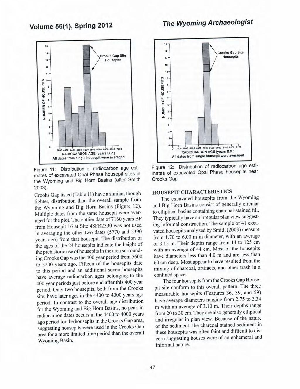
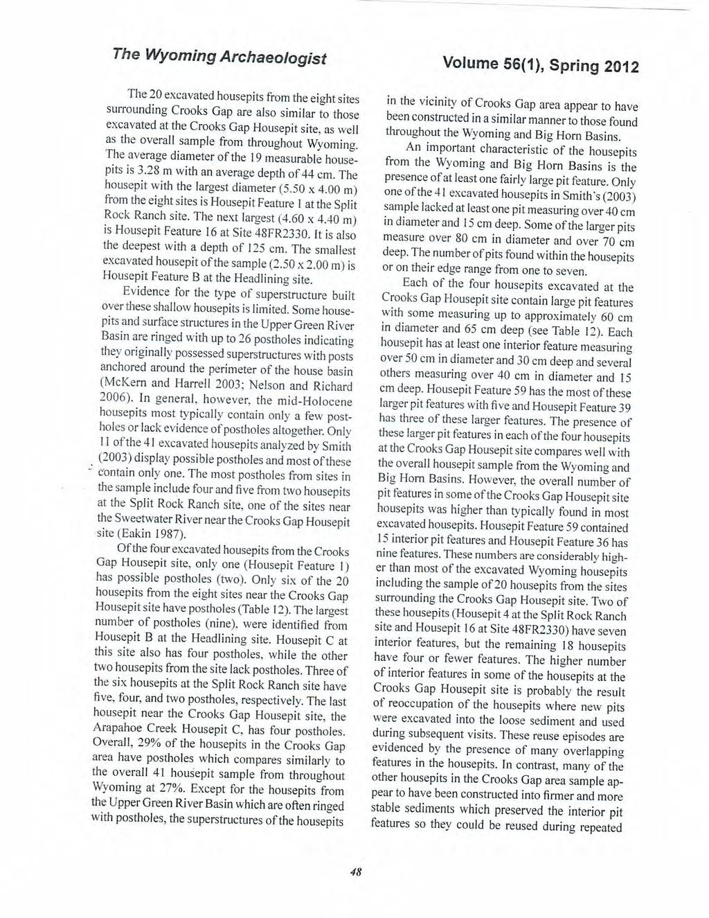
THE CROOKS GAP HOUSEPIT SITE AND OTHER NEARBY MID-HOLOCENE HOUSEPITS
|
|
|
- Dora Monica Farmer
- 5 years ago
- Views:
Transcription
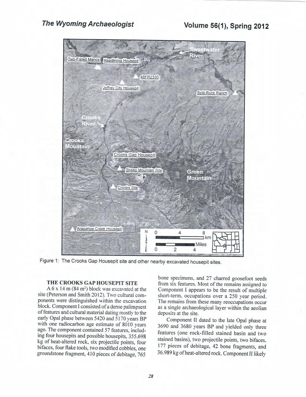
1 Volume 56(1 ), Spring 2012 The Wyoming Archaeologist THE CROOKS GAP HOUSEPIT SITE AND OTHER NEARBY MID-HOLOCENE HOUSEPITS by Craig S. Smith Marcia Peterson INTRODUCTION This article summarizes excavation results at the Crooks Gap Housepit site (Site 48FR6260) completed by Cardno ENTR1X in 20 l O and then compares those results with 20 other excavated housepits at eight sites located within 20 km of the site (Figure 1 ). The results are provided in more detail in Peterson and Smith (2012). The Crooks Gap Housepit site is a multicomponent site situated in aeolian deposits near Crooks Creek in southeastern Fremont County, Wyoming. One of the components contains the remains of four housepits dating between 5420 and 5170 years BP. It is one of a growing number of sites in the Wyoming and Big Horn Basins containing excavated housepits dating to the mid-holocene (Buenger and Goodrick 2011; Larson 1997; Rose 2008; Smith 2003). The site is in an area where 20 additional housepits have been excavated, thereby providing an opportunity to examine comparatively this subset of excavated housepits. The Crooks Gap Housepit site is in Crooks Gap directly between Green Mountain to the east and Crooks Mountain to the west and at the southwest edge of the Sweetwater Arch near the northern edge of the Great Divide Basin in the center of the Wyoming Basin. The gap comprises a prominent natural pass between the Great Divide Basin to the south and the Sweetwater River valley to the north. The site is east of Crooks Creek, a small perennial creek which flows northward through Crooks Gap to the Sweetwater River. Natural grass meadows are present along the creek and its tributaries, some of which were developed as historic hay meadows. The site is approximately 12 m higher than the creek and provides a good view of the creek and adjacent valley bottom to the west and north. The deposits encapsulating the cultural remains at the site consists of aeolian silt to silty sand which accumulated in the lee of a low ridge spur to the south. Those sediments rest on top of a deposit comprised primarily of granite cobbles and boulders and were in tum capped by a surface veneer of granite cobbles and small boulders deposited subsequent to formation of the aeolian deposit. The Crooks Gap Housepit site is at a modern ecotone providing access to resources associated with sagebrush steppe and riparian biomes within the Crooks Creek valley bottom, escarpment-foothill transition and limber and lodgepole woodlands biomes in the adjacent mountains, and the desert shrub biome in the Great Divide Basin. The Wyoming big sagebrush community dominates the area surrounding the site with shrub-dominated riparian vegetation with wet meadows along Crooks Creek and a band oflimber pine and juniper along the east edge of the Crooks Creek valley floor. Limber pine woodland is also present on the mountain slopes adjacent to the site. Potential toolstone material sources in the site area are limited. The Tertiary formation underlying the site area is a poor source of quality toolstone material, and most local tool stone, if any, comes from secondary sources. Much of the prehistoric tool stone acquisition associated with the site involved the use of secondary gravel and cobbles from lag and fluvial deposits in the area. Some toolstone material may also have originated from the Laney and Tipton members of the Green River formation, which outcrop along the face of the Delaney Rim escarpment at the south edge of the Great Divide Basin/north edge of the Washakie Basin approximately 90 km south of the site. 27
2
3
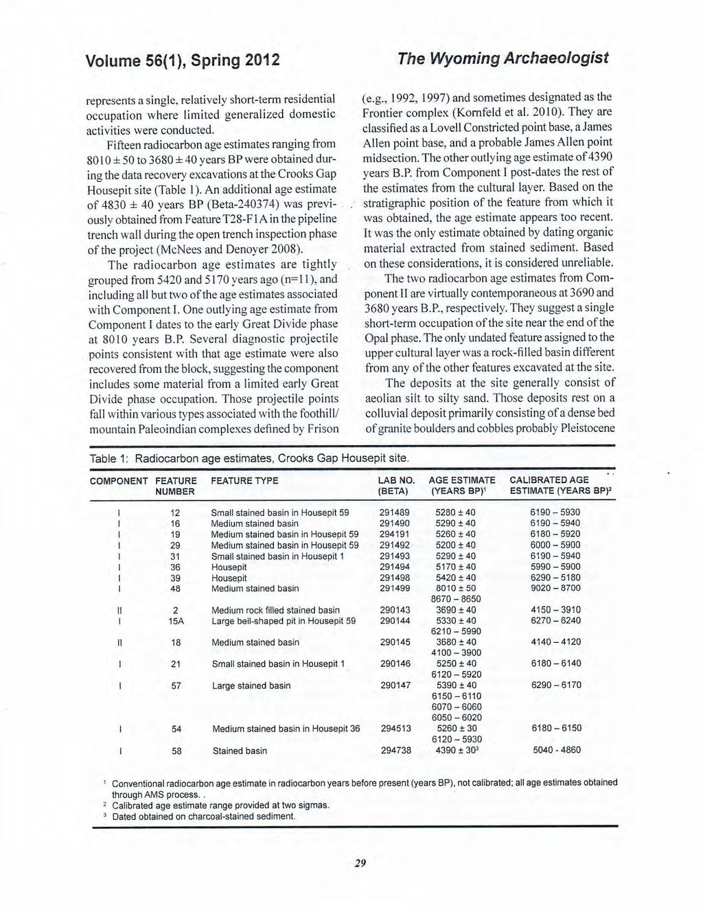
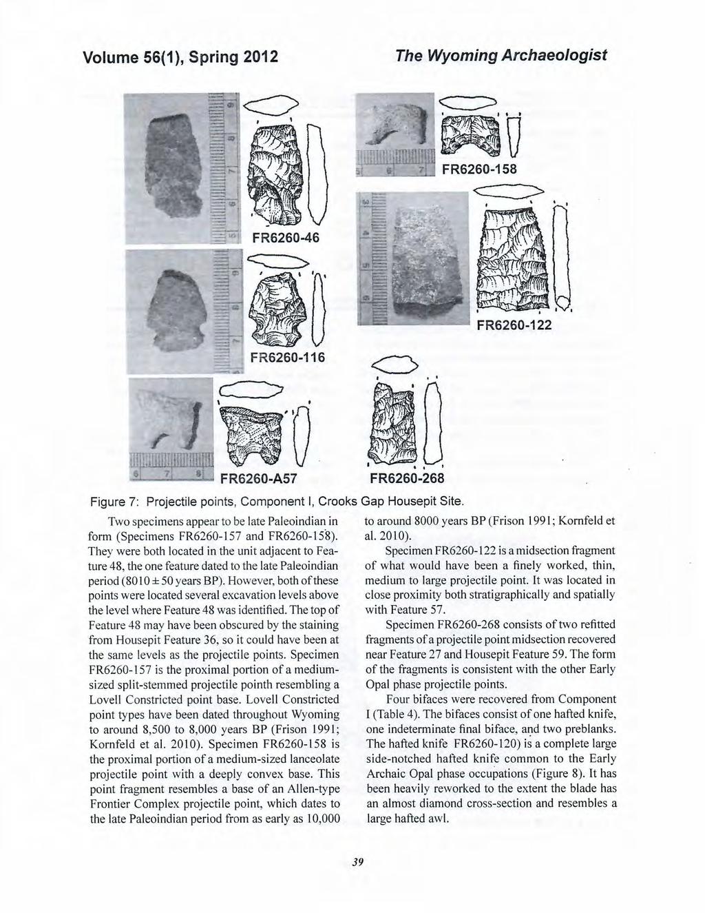
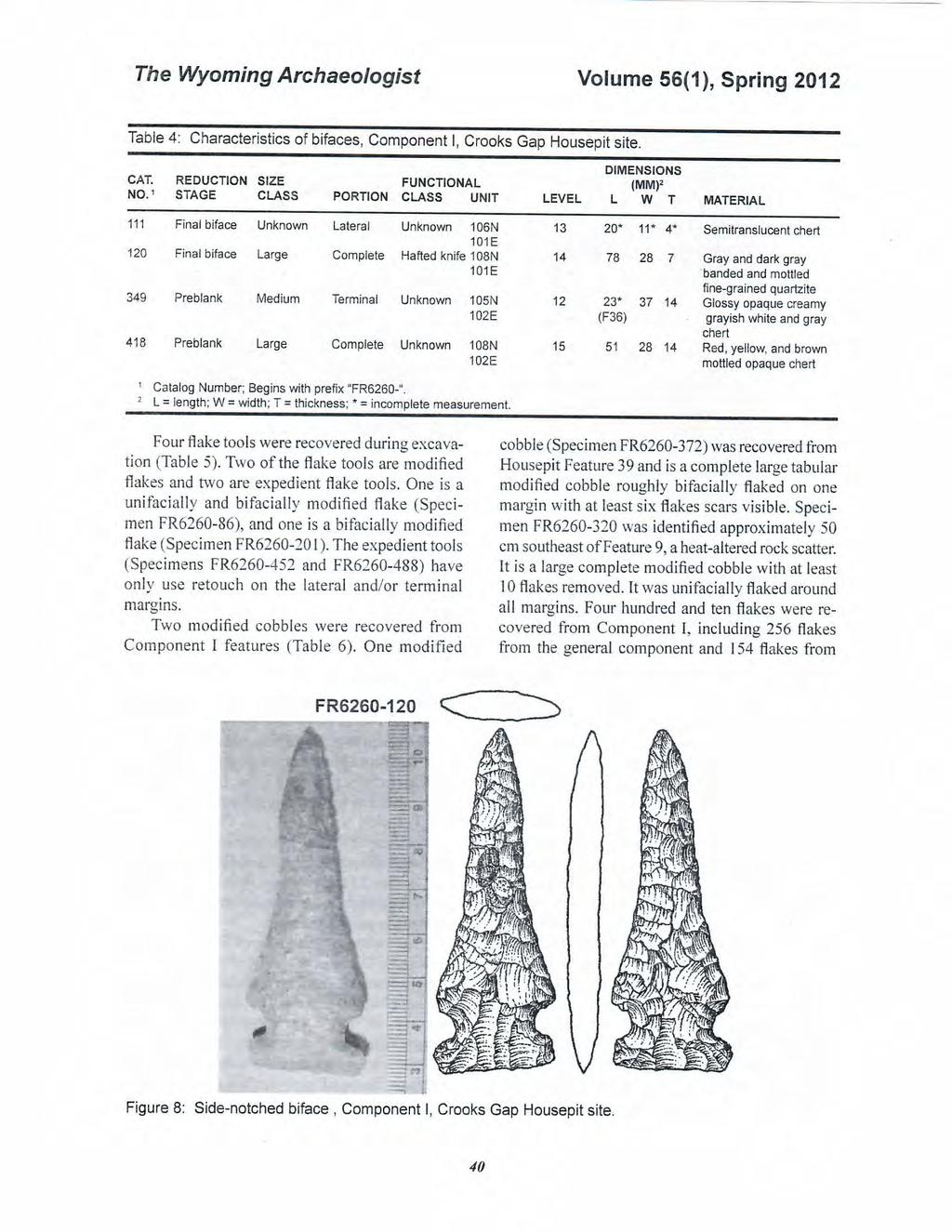
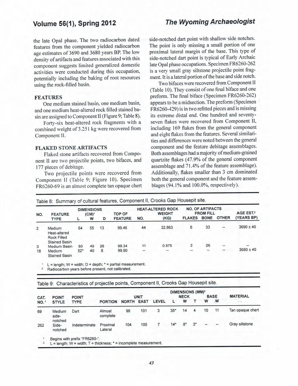
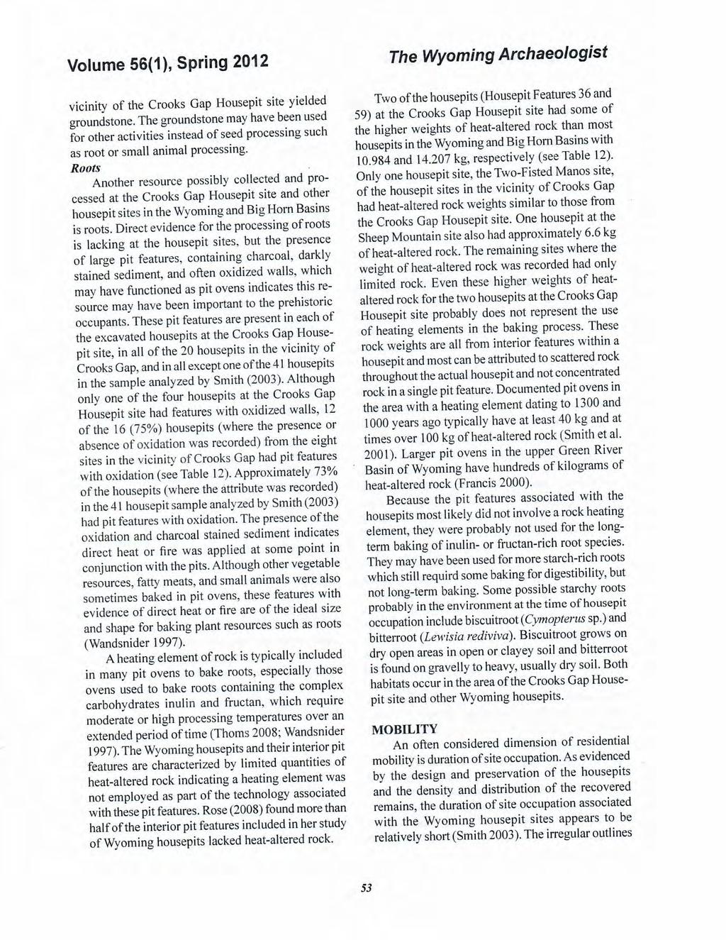
4 The Wyoming Archaeologist in age. The aeolian deposits accumulated in the lee of a low rise to the south. The prehistoric inhabitants of the site initially constructed their housepits and features after a shallow aeolian leeside deposit had formed over the underlying granite boulders. In several instances, these features encountered subsurface boulders the prehistoric inhabitants had not anticipated and which required modification of the features. The aeolian deposits then continued to aggrade slowly during the span of occupations represented in the excavation block, until sometime after the final occupation, when the ground surface stabilized and a soil formed. The modem surface deposit is a mix of aeolian deposits and colluvium with a surface veneer of granite cobbles and boulders. Four stratigraphic units and two stained cultural layers were defined (Figure 2). Stratum I consists of light olive brown colluvial and alluvial sediment over and around the underlying granite boulder deposit. It is a slightly consolidated poorly sorted sand, mostly medium grains with some coarse grains and approximately 25% small gravel. The stratum lacks root channels at this depth, but there is extensive charcoal staining leached and intermixed by burrowing animals from above. Stratum II consists of aeolian yellowish to light yellowish brown silty poorly sorted sand with slightly finer-grained sand and more silt than Stratum I. It is approximately 20% small gravel and< I% root channels. The tops of the large granite boulders begin to appear in the bottom of this stratum. This stratum contains the two stained cultural layers, which range from grayish brown to very dark gray. Excavation was halted at or near the base of this stratum across the excavation block, except in the south end of the block, where portions of Stratum I were excavated. Stratum lll is well consolidated brown to pale brown silt with some fine- to medium-grained sand. It consists of a continuation of the aeolian deposits comprising Stratum Il and is a possible A horizon with some possibly very lightly stained sediment. It is approximately I 0-15% small gravel and I% root channels. Stratum IV is the reclaimed topsoil on the pipeline right-of-way. It was removed across the excavation block before start of excavations. The two stained cultural layers with which Components I and 11 are associated are encapsulated Volume 56(1), Spring 2012 within Stratum II across the entire block. The cultural deposit generally consists of an upper lightly stained layer with which Component IL is associated and an underlying moderately to darkly stained layer with which Component I is associated. The two stained layers followed the slope of the aeolian deposit from south to no1th across the excavation block. However, the lower layer sloped at a slightly greater angle as the depth of the deposit increased from south to north. As a result, the cultural layers were more vertically compressed relative to each other in the south pa1t of the block. and more distinct in the central part of the block. They taper off in the northern part of the block, where the upper stained layer intersected the ground surface and the staining associated with the lower cultural layer faded away and the cultural layer thickened. The intermixing of material from the early Opal phase occupations and the Great Divide phase occupation(s) occurred primarily in the north part of the block. COMPONENT I The remains assigned to Component I-including four housepits with many overlapping interior stained basins-appear to be the result of repeated residential, though perhaps short-term, occupations occurring over the 250 year period dating between 5420 and 5170 years BP. This time span falls within the early Opal phase of the Early Archaic period. The remains f r om these reoccupations occur as a single archaeological layer within the sand deposits at the site. The component also contains a smaller amount of cultural material from an earlier occupation. FEATURES The 57 features assigned to Component I includes one housepit (Feature 36) with up to nine interior features, one housepit (Feature 39) with up to four interior features, one possible housepit (Feature 59) with up to 12 interior features, and one possible housepit (Feature I) with up to eight features. Features found outside of the housepits are 13 stained basins, three heat-altered rock scatters, one heat-altered rock filled basin, one post mold, and two large bell-shaped pits (Figure 3; Table 2). Housepit Feature 36 was a darkly stained but poorly defined housepit with up to nine interior basins (Figures 4 and 5). The boundaries and interior 30
 ' J -- oulder Prominen t krotavina O Possible heat-altered rock -----(_.., -------;; ----- - -- Reclaimed Ground Surface -=- ----J.")
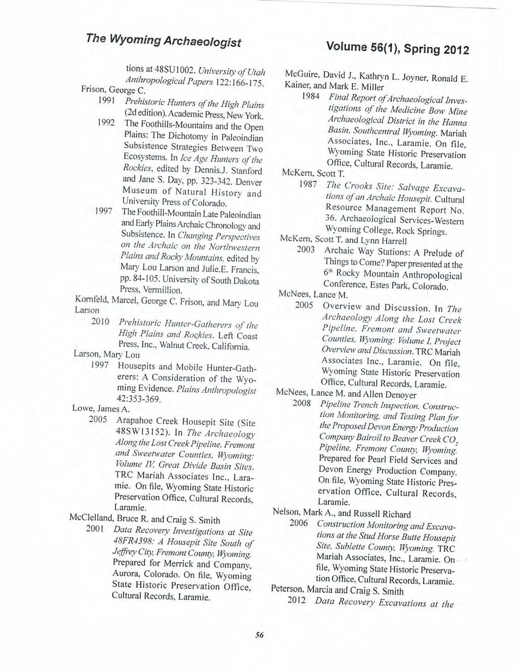
5 103.00N I Depth (m) C: 3 CD c.n O') - - :;! CD CQ );:., ::, Q) CD 0 0 CQ cii' N I 99.00N I N I N N I ""' - IV TH!Lightly Stained Sediment --- II /F4 (Possible Housepit) ' J -- oulder Prominen t krotavina O Possible heat-altered rock -----(_.., ;; Reclaimed Ground Surface -=- ----J @ -- -;---..,,. /F39(ProbableHousepit) Moderately --..._ 0 1 j DarklyStamed -... _'-- lj Q2,::_"N 1, /..., tamed / \ I o o V - -, : Boulders '- _..:_: Boulder/Cobble Scatter Edge N I III rv N I Fossil Anthill N I m _j -, - -r=.r _ N I Reclaimed Ground Surface N I / JV Lightly Stained N I Depth (m) =--=- - -=--=--= --=- --=- -= J l -=--=--= - _4:: n!: (E) : >:;---- -_-_-_-_-- - _ /ightly Stained _ I F47 ' '\ Darkly Stained Moderately stained Figure 2: Stratigraphic profile of the west wall of the excavation block from 98. DON to 108. OON, Crooks Gap Housepit site.
6
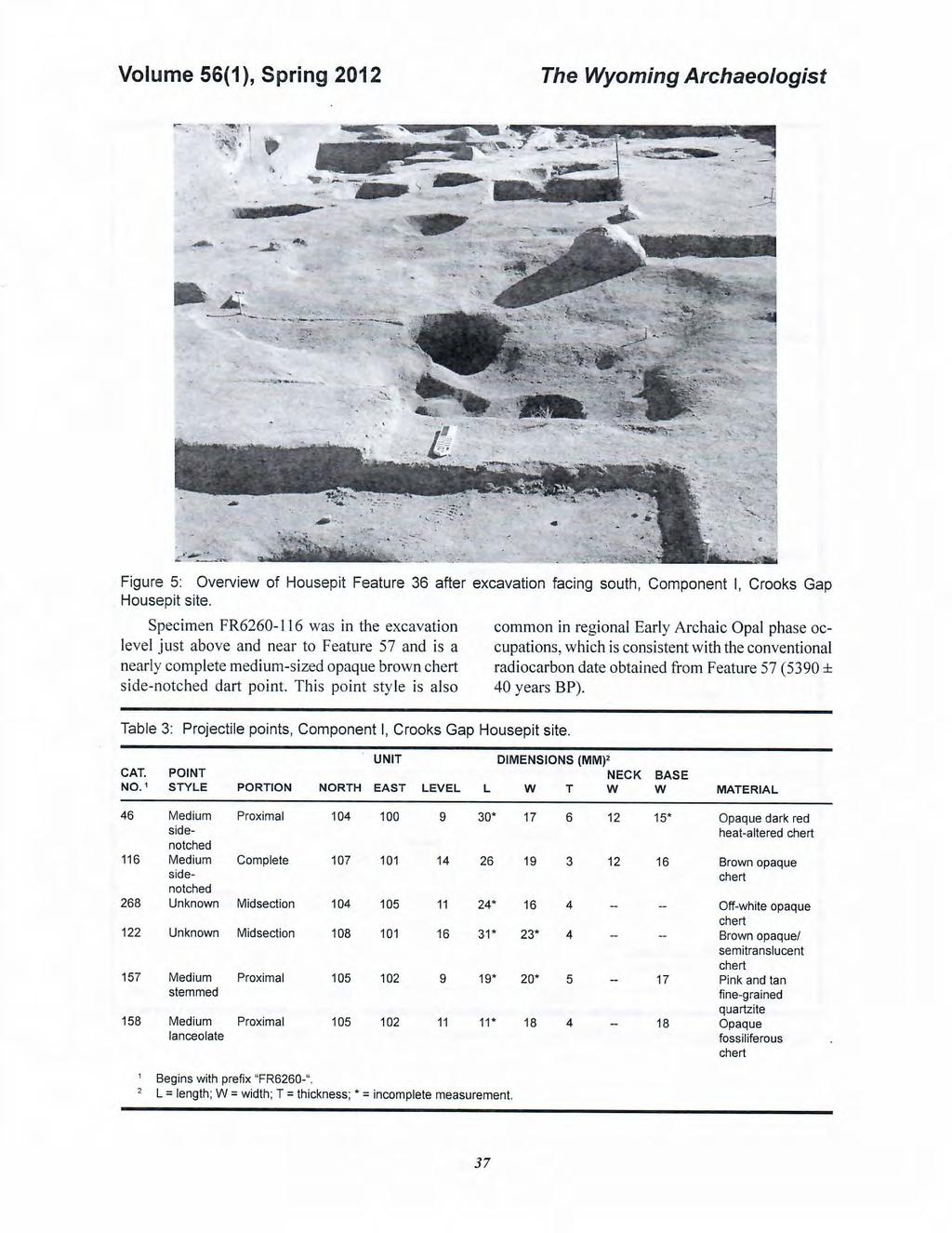
7
8
9
10
11
12
13
14
15
16
17
18
19
20
21
22
23
24
25
26
27
28

29
30
31
December 13, Kirk Shields Green Mountain Power 163 Acorn Lane Colchester, VT 05446
 December 13, 2017 Kirk Shields Green Mountain Power 163 Acorn Lane Colchester, VT 05446 RE: End of Field Letter for Archaeological Phase II Site Evaluation at Site VT-CH-1218 within the Proposed Milton
Lowest and Youngest Terrace : Soil Pit #4
 Lowest and Youngest Terrace : Soil Pit #4 Observations : Where : Huntington Terraces Climate : Cloudy, mid 60 s Our soil pit was the lowest of the 4 sites The pit site was located on the right side of
Table 9. FAI accession log
 Table 9. FAI-02045 accession log UA Accession # FS # Depth (cm BS) Artifact Type n= Material Color UA2010-187-0001 1 5-10 utilized flake 1 basalt black UA2010-187-0002 2 5-10 flake 1 chert black UA2010-187-0003
SUPPLEMENTAL MATERIAL
 SUPPLEMENTAL MATERIAL DESCRIPTIONS OF OTHER STRATIGRAPHIC SECTIONS Cherry Creek In its middle reaches, Cherry Creek meanders between three paired terraces within a narrow bedrock valley. The highest is
Archaeological Survey and Evaluation at 8954 El Dorado Parkway, El Cajon, San Diego County, California
 April 16, 2013 Ms. Andrea Bitterling Helix Environmental Planning, Inc. 7578 El Cajon Blvd., Suite 200 El Cajon, California 91942 Re: Archaeological Survey and Evaluation at 8954 El Dorado Parkway, El
Starting at Rock Bottom
 Starting at Rock Bottom At rock bottom of the Brushy Creek site s geological column lies the first clue to human habitation: A smelting and heattreating furnace, and mold, carved into Bed Ked: Figure 15
Sediment and sedimentary rocks Sediment
 Sediment and sedimentary rocks Sediment From sediments to sedimentary rocks (transportation, deposition, preservation and lithification) Types of sedimentary rocks (clastic, chemical and organic) Sedimentary
DETAILED DESCRIPTION OF STREAM CONDITIONS AND HABITAT TYPES IN REACH 4, REACH 5 AND REACH 6.
 DETAILED DESCRIPTION OF STREAM CONDITIONS AND HABITAT TYPES IN REACH 4, REACH 5 AND REACH 6. The Eklutna River was divided into study reaches (figure 1) prior to this site visit. Prominent geologic or
Starting at Rock Bottom: A Peculiar Central Texas PreClovis Culture
 Starting at Rock Bottom: A Peculiar Central Texas PreClovis Culture Background Brushy Creek grades, overall, west-northwest (WNW) to east-southeast (ESE) through the easternmost portions of the central
Using Ground Conductivity as a Geophysical Survey Technique to Locate Potential Archaeological Sites in the Bad Axe River Valley of Western Wisconsin
 Using Ground Conductivity as a Geophysical Survey Technique to Locate Potential Archaeological Sites in the Bad Axe River Valley of Western Wisconsin Anthony J. Beauchaine, Elizabeth Werdemann Faculty
L.O: SLOWING STREAMS DEPOSIT (SORT) SEDIMENT HORIZONTALLY BY SIZE.
 SEDIMENT HORIZONTALLY BY SIZE.") L.O: SLOWING STREAMS DEPOSIT (SORT) SEDIMENT HORIZONTALLY BY SIZE. 1. Base your answer to the following question on the profile shown below, which shows the pattern of horizontal sorting produced at a
L.O: SLOWING STREAMS DEPOSIT (SORT) SEDIMENT HORIZONTALLY BY SIZE. 1. Base your answer to the following question on the profile shown below, which shows the pattern of horizontal sorting produced at a
 UNIT DESCRIPTIONS: Artificial Fill, Undocumented (Afu): Locally derived sandy silt and silty sand, locally with clay and varying amounts of gravel and man-made debris. Abundant concrete rubble, in places
FLUVIAL LANDFORMS. Floodplains
 FLUVIAL LANDFORMS Floodplains fairly flat & continuous surface occupying much of a valley bottom normally underlain by unconsolidated sediments subject to periodic flooding (usually once every year or
CHAPTER 4. Blue Heron Site (47Je1001) 2003 Investigations. By Chrisie L. Hunter
 2003 Investigations. By Chrisie L. Hunter") CHAPTER 4 Blue Heron Site (47Je1001) 2003 Investigations By Chrisie L. Hunter Introduction The Blue Heron site (47Je1001) is on the property of the Crescent Bay Hunt Club, which is located in the NE 1/4
CHAPTER 4 Blue Heron Site (47Je1001) 2003 Investigations By Chrisie L. Hunter Introduction The Blue Heron site (47Je1001) is on the property of the Crescent Bay Hunt Club, which is located in the NE 1/4
Evaluation/Monitoring Report No. 152
 Evaluation/Monitoring Report No. 152 150m west of 7 Portmore Rd. Portmore Lower Ballinderry County Antrim LICENCE NO.: AE/07/241 David McIlreavy 1 Site Specific Information Site Name Townland County :
Groundwater Investigation SOUTHGATE GRAVEL PIT Part of Lot 15, Concession 15 (formerly Township of Proton), Township of Southgate.
, Township of Southgate.") Groundwater Investigation SOUTHGATE GRAVEL PIT Part of Lot 15, Concession 15 (formerly Township of Proton), Township of Southgate County of Grey October, 2014 Prepared for: Drysdale Aggregate Consulting
Groundwater Investigation SOUTHGATE GRAVEL PIT Part of Lot 15, Concession 15 (formerly Township of Proton), Township of Southgate County of Grey October, 2014 Prepared for: Drysdale Aggregate Consulting
16 January 2018 Job Number: RICHARD NEWMAN C\- CLARK FORTUNE MCDONALD AND ASSOCIATES PO BOX 553 QUEENSTOWN
 16 January 2018 Job Number: 50595 RICHARD NEWMAN C\- CLARK FORTUNE MCDONALD AND ASSOCIATES PO BOX 553 QUEENSTOWN CHANSEN@CFMA.CO.NZ STORMWATER DISPOSAL ASSESSMENT Dear Richard, RDAgritech were requested
Evolution of the conceptual hydrogeologic and ground-water flow model for Las Vegas Valley, Clark County, Nevada
 Evolution of the conceptual hydrogeologic and ground-water flow model for Las Vegas Valley, Clark County, Nevada Geological Society of America Annual Meeting November 14, 2 David J. Donovan Southern Nevada
Chapter 6 Pages of Earth s Past: Sedimentary Rocks
 Chapter 6 Pages of Earth s Past: Sedimentary Rocks Introduction! Drilling into the bottom of the North Sea, we encounter: " Soft mud and loose sand, silt, pebbles, and shells. Then: " Similar materials
DATA REPOSITORY FIGURES AND TABLES
 GSA Data Repository Item 2016322 Sweeney, K.E., and Roering, J.J., 2016, Rapid fluvial incision of a late Holocene lava flow: Insights from lidar, alluvial stratigraphy, and numerical modeling: GSA Bulletin,
Seismic Reflection Imaging across the Johnson Ranch, Valley County, Idaho
 Seismic Reflection Imaging across the Johnson Ranch, Valley County, Idaho Report Prepared for the Skyline Corporation Lee M. Liberty Center for Geophysical Investigation of the Shallow Subsurface (CGISS)
3.3 CLIMATE, GEOLOGY, TOPOGRAPHY, AND SOILS CLIMATE GEOLOGY TOPOGRAPHY
 3.3 CLIMATE, GEOLOGY, TOPOGRAPHY, AND SOILS This section describes the climate, geology, topography, and soil resource characteristics of the Yolo Bypass Wildlife Area (Wildlife Area). Agricultural soil
Don Elsenheimer, Ph.D Glenn Melchert Minnesota Dept. Natural Resources
 Regional Survey of Gold in Till, Bigfork Greenstone Belt, St. Louis & Itasca Counties, Minnesota: Follow-up Trenching in Areas with Anomalously High Gold Grain Counts Don Elsenheimer, Ph.D Glenn Melchert
6.11 Naas River Management Unit
 6.11 Naas River Management Unit 6.11.1 Site 41 Issue: Bed and bank erosion Location: E 0685848 N 6058358 Waterway: Naas River Management Unit: Naas River Facing downstream from Bobeyan Rd bridge Facing
The Soils and Land Capability for Agriculture. Land North of Aberdeen, Aberdeenshire
 The Soils and Land Capability for Agriculture Of Land North of Aberdeen, Aberdeenshire Report prepared for Peter Radmall Associates May 2012 Reading Agricultural Consultants Ltd Beechwood Court, Long Toll,
Clyde River Landslide
 Clyde River Landslide Department of Geology, Perkins Hall, University of Vermont, Burlington, VT 05405 Abstract: This paper investigates a landslide on the Clyde River in Newport, Vermont. The landslide
The Geomorphology of the Pig Point Site (18AN50) Landform Development, Climate Change, and Long-Term Human Occupation
 Landform Development, Climate Change, and Long-Term Human Occupation") The Geomorphology of the Pig Point Site (18AN50) Landform Development, Climate Change, and Long-Term Human Occupation D O N M U L L I S T E T R A T EC H S T E P H A N I E S P E R L I N G A N N E A R U
The Geomorphology of the Pig Point Site (18AN50) Landform Development, Climate Change, and Long-Term Human Occupation D O N M U L L I S T E T R A T EC H S T E P H A N I E S P E R L I N G A N N E A R U
Correlation of gravel deposits from trenching project on Alder Creek fluvial terrace near Point Arena, California
 Correlation of gravel deposits from trenching project on Alder Creek fluvial terrace near Point Arena, California Aletha Lee Department of Geology and Geography, West Virginia University, White Hall, Morgantown,
=%REPORT RECONNAISSANCE OF CHISHOLM LAKE PROSPECT. October 25, 1977
 =%REPORT ON FIELD RECONNAISSANCE OF CHISHOLM LAKE PROSPECT October 25, 1977 Bruce D. Vincent Imperial Oil Limited, Minerals - Coal, CALGARY, ALBERTA CHISHOLM LAKE PROSPECT Introduction The Chisholm Lake
APPENDIX E. GEOMORPHOLOGICAL MONTORING REPORT Prepared by Steve Vrooman, Keystone Restoration Ecology September 2013
 APPENDIX E GEOMORPHOLOGICAL MONTORING REPORT Prepared by Steve Vrooman, Keystone Restoration Ecology September 2 Introduction Keystone Restoration Ecology (KRE) conducted geomorphological monitoring in
Laboratory Exercise #4 Geologic Surface Processes in Dry Lands
 Page - 1 Laboratory Exercise #4 Geologic Surface Processes in Dry Lands Section A Overview of Lands with Dry Climates The definition of a dry climate is tied to an understanding of the hydrologic cycle
Evaluation/Monitoring Report No. 259
 SITE 100M EAST OF 16 LEARMORE ROAD CASTLEGORE CASTLEDERG COUNTY TYRONE LICENCE NO.: AE/13/36E NAOMI CARVER 1 Site Specific Information Site Name: 100m east of 16 Learmore Road, Castlederg, Co. Tyrone Townland:
R.J. Burnside & Associates Limited telephone fax web Via:
 R.J. Burnside & Associates Limited 292 Speedvale Avenue West Unit 20 Guelph ON N1H 1C4 CANADA telephone (519) 823-4995 fax (519) 836-5477 web www.rjburnside.com November 13, 2014 Via: Email Ms. Nancy Shoemaker
Objectives. Introduction to Soils. Terms to know: What is soil? Study of Soils. The Soil Body 11/9/2012
 Objectives Explain what soil is and where it comes from Define a soil body List examples of the five soil-forming factors Explain how soils develop Introduction to Soils Terms to know: What is soil? Alluvial
Lab 7: Sedimentary Structures
 Name: Lab 7: Sedimentary Structures Sedimentary rocks account for a negligibly small fraction of Earth s mass, yet they are commonly encountered because the processes that form them are ubiquitous in the
Additional Testing for Padre Dam Eastern Service Area Secondary Connection- Alternative Site Location, San Diego County, California
 Mark Niemiec Padre Dam Municipal Water District P.O. Box 719003 9300 Fanita Parkway Santee, California 92072 Re: Additional Testing for Padre Dam Eastern Service Area Secondary Connection- Alternative
Waterbury Dam Disturbance Mike Fitzgerald Devin Rowland
 Waterbury Dam Disturbance Mike Fitzgerald Devin Rowland Abstract The Waterbury Dam was completed in October 1938 as a method of flood control in the Winooski Valley. The construction began in April1935
Redwood City Harbor, California, Navigation Improvement Feasibility Study. Appendix D. Geotechnical Engineering. DRAFT April 2015
 1 Redwood City Harbor, California, Navigation Improvement Feasibility Study Appendix D Geotechnical Engineering DRAFT April 2015 2 Contents 1 Purposes of Report... 3 2 Background... 3 3 References and
A study of the variation in the Rooikoppie gravels in the Lower Vaal area
 A study of the variation in the Rooikoppie gravels in the Lower Vaal area A study of the variation in the Rooikoppie gravels in the Lower Vaal area M. Ndwammbi Rockwell Diamonds Inc The Rooikoppie gravel
Geology and New England Landscapes
 Geology and New England Landscapes Jim Turenne, CPSS USDA-NRCS Warwick, RI. http://nesoil.com Why Geology? Provides the big picture of site conditions. Major part of soil formation (parent material and
patersongroup Mineral Aggregate Assessment 3119 Carp Road Ottawa, Ontario Prepared For Mr. Greg LeBlanc March 7, 2014 Report: PH2223-REP.
 Geotechnical Engineering Environmental Engineering group Hydrogeology Geological Engineering Archaeological Studies Materials Testing 3119 Carp Road Prepared For Mr. Greg LeBlanc March 7, 2014 Paterson
Conceptual Model of Stream Flow Processes for the Russian River Watershed. Chris Farrar
 Conceptual Model of Stream Flow Processes for the Russian River Watershed Chris Farrar Several features of creeks affect the interactions between surface and groundwater. This conceptual model uses the
Betsy Stevenson and Allison Mohrs (Skagit County Planning and Development Services) Jenny Baker, The Nature Conservancy
 Jenny Baker, The Nature Conservancy") TC Fisher Slough Final Design and Permitting Subject: Well Review Memorandum To: From: Betsy Stevenson and Allison Mohrs (Skagit County Planning and Development Services) Jenny Baker, The ature Conservancy
TC Fisher Slough Final Design and Permitting Subject: Well Review Memorandum To: From: Betsy Stevenson and Allison Mohrs (Skagit County Planning and Development Services) Jenny Baker, The ature Conservancy
Aquifer an underground zone or layer of sand, gravel, or porous rock that is saturated with water.
 Aggradation raising of the streambed by deposition that occurs when the energy of the water flowing through a stream reach is insufficient to transport sediment conveyed from upstream. Alluvium a general
DATA REPOSITORY MATERIAL: PALEOCHANNEL GROUP MAPPING DESCRIPTIONS
 Data Repository item 2695 DATA REPOSITORY MATERIAL: PALEOCHANNEL GROUP MAPPING DESCRIPTIONS Groups 1 (North Myrtle Beach) and 2 (Atlantic Beach) Channel Groups 1 (North Myrtle Beach) and 2 (Atlantic Beach)
Hydrogeological Assessment for Part of Lots 2 and 3, Concession 5, Township of Thurlow, County of Hastings 1.0 INTRODUCTION. 1.
 February 10,2017 25506400 Ontario Ltd. Foxboro, ON Attention: Brad Newbatt Re: Hydrogeological Assessment for Part of Lots 2 and 3, Concession 5, Township of Thurlow, County of Hastings 1.0 INTRODUCTION
Do you think sediment transport is a concern?
 STREAM RESTORATION FRAMEWORK AND SEDIMENT TRANSPORT BASICS Pete Klingeman 1 What is Your Restoration Project Like? k? Do you think sediment transport is a concern? East Fork Lewis River, WA Tidal creek,
Bell Ringer. Are soil and dirt the same material? In your explanation be sure to talk about plants.
 Bell Ringer Are soil and dirt the same material? In your explanation be sure to talk about plants. 5.3 Mass Movements Triggers of Mass Movements The transfer of rock and soil downslope due to gravity is
Appendix 4 Detailed Terrain Analysis Report
 Appendix 4 Detailed Terrain Analysis Report Helliwell Provincial Park Ecosystem Based Plan March 2001 Terrain Mapping Introduction Helliwell Park is located on the eastern peninsula of Hornby Island, British
SUPPLEMENTARY INVESTIGATION AND LABORATORY TESTING Aggregate Resource Evaluation Proposed Bernand Quarry San Diego County, California
 October 3, 2 Mr. Mark San Agustin Project No. 28-- Home Land Investments Document No. -92 2239 Curlew Street San Diego, CA 92 SUBJECT: SUPPLEMENTARY INVESTIGATION AND LABORATORY TESTING Aggregate Resource
Lecture 29: Soil Formation
 Lecture 29: Soil Formation Factors Controlling Soil Formation 1. Parent material: Soil precursor 2. Climate: Temperature and precipitation 3. Biota: Native vegetation, microbes, soil animals, humans 4.
APPENDIX G GLOSSARY. Mn/DOT/WR-0200
 APPENDIX G GLOSSARY Mn/DOT/WR-0200 Alluvial - comprised of clay, silt, sand, gravel, and/or other detritus deposited by water. Usually refers to accretionary overbank, floodplain or levee deposits. Biomantling
11/22/2010. Groundwater in Unconsolidated Deposits. Alluvial (fluvial) deposits. - consist of gravel, sand, silt and clay
 deposits. - consist of gravel, sand, silt and clay") Groundwater in Unconsolidated Deposits Alluvial (fluvial) deposits - consist of gravel, sand, silt and clay - laid down by physical processes in rivers and flood plains - major sources for water supplies
Groundwater in Unconsolidated Deposits Alluvial (fluvial) deposits - consist of gravel, sand, silt and clay - laid down by physical processes in rivers and flood plains - major sources for water supplies
Your web browser (Safari 7) is out of date. For more security, comfort and the best experience on this site: Update your browser Ignore
 is out of date. For more security, comfort and the best experience on this site: Update your browser Ignore") Your web browser (Safari 7) is out of date. For more security, comfort and the best experience on this site: Update your browser Ignore ALLU VIAL FAN colluvial fan, debris cone For the complete encyclopedic
Your web browser (Safari 7) is out of date. For more security, comfort and the best experience on this site: Update your browser Ignore ALLU VIAL FAN colluvial fan, debris cone For the complete encyclopedic
SL GEOLOGY AND MINING. Coal bearing strata in the project area are referable primarily to the Allegheny Group of
 SL-145-1 GEOLOGY AND MINING Coal bearing strata in the project area are referable primarily to the Allegheny Group of Pennsylvania age. These rocks occur as dissected remnants overlying the ridge-forming
SUPPLEMENTAL INFORMATION DELFT 3-D MODELING: MODEL DESIGN, SETUP, AND ANALYSIS
 GSA DATA REPOSITORY 2014069 Hajek and Edmonds SUPPLEMENTAL INFORMATION DELFT 3-D MODELING: MODEL DESIGN, SETUP, AND ANALYSIS Each experiment starts from the initial condition of a straight channel 10 km
Upper Owyhee Watershed Assessment
 * Owyhee Watershed Council and Scientific Ecological Services The upper Owyhee subbasin is located in parts of three states: the southeastern corner of Oregon, the southwestern corner of Idaho, and north
Figure 1 The map shows the top view of a meandering stream as it enters a lake. At which points along the stream are erosion and deposition dominant?
 1. In which type of climate does chemical weathering usually occur most rapidly? 1. hot and dry 3. cold and dry 2. hot and wet 4. cold and wet 2. Figure 1 The map shows the top view of a meandering stream
Archaeological Work at Tchinguiz Tepe: Verifying the Results of Geophysical Surveying Using Radar
 IPAEB. Volume II Archaeological Work at Tchinguiz Tepe: Verifying the Results of Geophysical Surveying Using Radar Oriol Achón, Enrique Ariño, Diego García, Josep M Gurt and Roger Sala RC The area chosen
Lectures Hydrology & Fluvial Geomorphology. Gauley River Images. Ancients' (= Biblical) Model of Water (Hydrologic) Cycle
 Model of Water (Hydrologic) Cycle") Lectures 11-13 13 Hydrology & Fluvial Geomorphology Gauley River Images http://www.youtube.com/watch?v=eulmuyegtz4&feature=related Ancients' (= Biblical) Model of Water (Hydrologic) Cycle Stream Water
Lectures 11-13 13 Hydrology & Fluvial Geomorphology Gauley River Images http://www.youtube.com/watch?v=eulmuyegtz4&feature=related Ancients' (= Biblical) Model of Water (Hydrologic) Cycle Stream Water
Soil Formation. Lesson Plan: NRES B2-4
 Soil Formation Lesson Plan: NRES B2-4 1 Anticipated Problems 1. What are five different factors that affect soil formation? 2. What are some different types of parent material that affect soils? 3. What
4. Soils and soil conditions
 4. Soils and soil conditions 4.1 General characteristics 4.1.1 Soil-forming processes Most soils of the Bardenas area show no distinct characteristics of soil development. Except in the ancient alluvium
Geomorphic Importance of Winter Peak Flows and Annual Snowmelt Hydrographs in a Sierra Nevada Boulder-Bedrock River
 Geomorphic Importance of Winter Peak Flows and Annual Snowmelt Hydrographs in a Sierra Nevada Boulder-Bedrock River Scott McBain and Bill Trush McBain & Trush, Inc. Clavey River and Cherry Creek vicinity
Sand. Sand is any eroded material (igneous, metamorphic or sedimentary) that has a grain size from 1/16 th to 2 millimeters in size.
 that has a grain size from 1/16 th to 2 millimeters in size.") Sedimentology 001 What is sedimentology? Sedimentology...encompasses the study of modern sediments such as sand [1], mud (silt) [2] andclay [3] and understanding the processes that deposit them.[4] It
Sedimentology 001 What is sedimentology? Sedimentology...encompasses the study of modern sediments such as sand [1], mud (silt) [2] andclay [3] and understanding the processes that deposit them.[4] It
Riparian Assessment. Steps in the right direction... Drainage Basin/Watershed: Start by Thinking Big. Riparian Assessment vs.
 Riparian Assessment vs. Monitoring Riparian Assessment What is a healthy stream? Determine stream/riparian health Determine change or trend, especially in response to mgmt Classification = designation
CRITERIA FOR DEFINING THE SERIES (DAR, 2006)
") CRITERIA FOR DEFINING THE SERIES (DAR, 2006) On the Soils Map of Catalonia (1:25 000), the soil series are defined on the basis of the following hierarchically organised criteria. Classification at the
CRITERIA FOR DEFINING THE SERIES (DAR, 2006) On the Soils Map of Catalonia (1:25 000), the soil series are defined on the basis of the following hierarchically organised criteria. Classification at the
GEOL 652. Poudre River Fieldtrip
 GEOL 652. Poudre River Fieldtrip One of the more difficult variables to measure and/or estimate when studying flow in natural channels is that of roughness. Roughness, usually approximated with Manning
American Institute of Professional Geologists South Dakota Section
 American Institute of Professional Geologists South Dakota Section 2015 Field Trip Guide Deadwood Formation in the Black Hills of South Dakota and Frac Sand Potential Saturday, September 12, 2015 1 Field
Essential Questions. What is erosion? What is mass wasting?
 Erosion Essential Questions What is erosion? What is mass wasting? What is Erosion? Erosion The transportation of sediment from one area to another Caused mainly by running water but also caused by glaciers,
 Page 1 of 9 Name: Base your answer to the question on the diagram below. The arrows show the direction in which sediment is being transported along the shoreline. A barrier beach has formed, creating a
SOILS RELATIVE TO GEOLOGY AND LANDFORMS IN WALNUT GULCH EXPERIMENTAL WATERSHED, ARIZONA, USA. W. R. Osterkamp, D. J. Breckenfeld, and J.J.
 SOILS RELATIVE TO GEOLOGY AND LANDFORMS IN WALNUT GULCH EXPERIMENTAL WATERSHED, ARIZONA, USA W. R. Osterkamp, D. J. Breckenfeld, and J.J. Stone ABSTRACT Soils of the Walnut Gulch Experimental Watershed
River Response. Sediment Water Wood. Confinement. Bank material. Channel morphology. Valley slope. Riparian vegetation.
 River Response River Response Sediment Water Wood Confinement Valley slope Channel morphology Bank material Flow obstructions Riparian vegetation climate catchment vegetation hydrological regime channel
MAFF Ministry of IfiriLE Agriculture Fisheries and Food
 MAFF Ministry of IfiriLE Agriculture Fisheries and Food STATEMENT OF PHYSICAL CHARACTERISTICS AND AGRICULTURAL LAND CLASSIFICATION UPSLAND, KIRKLINGTON NORTH YORKSHIRE EXTRACTION OF SAND AND GRAVEL MARCH
How to Identify and Properly Classify Drill Cuttings
 How to Identify and Properly Classify Drill Cuttings (Creating Useful Borehole Logs) Dave Larson Hydrogeology and Geophysics Section Accurate information about the borehole location and a careful description
Curtis Monger USDA-NRCS Developments in Soil Taxonomy
 Curtis Monger USDA-NRCS Developments in Soil Taxonomy rice ANTHROPOCENE? Ca Curtis Monger USDA-NRCS Developments in Soil Taxonomy rice ANTHROPOCENE? Soil sustainability differs across the landscape. Ca
Dakota Sandstone. of the Moxa Arch and Surrounding Green River Basin
 Dakota Sandstone of the Moxa Arch and Surrounding Green River Basin Dakota Sandstones of the Green River Basin Overview The Dakota sandstones of the Moxa Arch and surrounding Green River Basin remain attractive
New York University Excavations at Amheida 2010 Geological Investigations LOCAL GEOLOGY
 New York University Excavations at Amheida 2010 Geological Investigations LOCAL GEOLOGY The geology of the Amheida area has been outlined previously by the site topographers; the general geomorphology
Daniel Koning, Peggy Johnson, and John Hawley. New Mexico Bureau of Geology and Mineral Resources
 Daniel Koning, Peggy Johnson, and John Hawley Daniel Koning 1, Gary Smith 2, and Adam Read 1 1 New Mexico Bureau of Geology and Mineral Resources 2 University of New Mexico Santa Fe Group Definition (Spiegel
Chapter 3. Description of the study area. Paul Taucher Melissa Thompson Nikolaus Gribb 3-17
 Chapter 3 Description of the study area Paul Taucher Melissa Thompson Nikolaus Gribb 3-17 The WBRB drainage basin covers approximately 25 percent of the state in north-central and northwestern Wyoming,
June 9, R. D. Cook, P.Eng. Soils Engineer Special Services Western Region PUBLIC WORKS CANADA WESTERN REGION REPORT ON
 PUBLIC WORKS CANADA WESTERN REGION REPORT ON GEOTECHNICAL INVESTIGATION PROPOSED MARTIN RIVER BRIDGE MILE 306.7 MACKENZIE HIGHWAY Submitted by : R. D. Cook, P.Eng. Soils Engineer Special Services Western
Assessment of biological remains from excavations at Newbridge Quarry, Pickering, North Yorkshire (site code: NBQ99)
") Reports from the Environmental Archaeology Unit, York 2000/27, 5 pp. Assessment of biological remains from excavations at Newbridge Quarry, Pickering, North Yorkshire (site code: NBQ99) by Allan Hall,
Reports from the Environmental Archaeology Unit, York 2000/27, 5 pp. Assessment of biological remains from excavations at Newbridge Quarry, Pickering, North Yorkshire (site code: NBQ99) by Allan Hall,
Chapter 3. Description of the Study Area. Karl Taboga, James Stafford and Paul Taucher 3-19
 Chapter 3 Description of the Study Area Karl Taboga, James Stafford and Paul Taucher 3-19 T his study examines groundwater resources that underlie the Bear River drainage basin in Wyoming as well as areas
OCR CARBON DATING OF THE WATSON BRAKE MOUND COMPLEX
 Presented at the symposium An Overview of Research at Watson Brake: A Middle Archaic Mound Complex in Northeast Louisiana during the 53rd Annual Meeting of the Southeastern Archaeological Conference, Birmingham,
Soils, Hydrogeology, and Aquifer Properties. Philip B. Bedient 2006 Rice University
 Soils, Hydrogeology, and Aquifer Properties Philip B. Bedient 2006 Rice University Charbeneau, 2000. Basin Hydrologic Cycle Global Water Supply Distribution 3% of earth s water is fresh - 97% oceans 1%
SOUTH CERRO AZUL STRATIGRAPHIC SECTION. Upper Cerro Azul flow of the Servilleta Basalt (Tsbcau) Lower Sandlin unit (Tsl)
 Lower Sandlin unit (Tsl)") Figure A3-01 cobbles claysilt general grain size sand pebbles vf f m c vc SOUTH CERRO AZUL STRATIGRAPHIC SECTION Top at 18 m. Upper Cerro Azul flow of the Servilleta Basalt (Tsbcau) 15 Basalt: Very dark
Figure A3-01 cobbles claysilt general grain size sand pebbles vf f m c vc SOUTH CERRO AZUL STRATIGRAPHIC SECTION Top at 18 m. Upper Cerro Azul flow of the Servilleta Basalt (Tsbcau) 15 Basalt: Very dark
Sediment and Sedimentary rock
 Sediment and Sedimentary rock Sediment: An accumulation of loose mineral grains, such as boulders, pebbles, sand, silt or mud, which are not cemented together. Mechanical and chemical weathering produces
This document downloaded from vulcanhammer.net vulcanhammer.info Chet Aero Marine
 This document downloaded from vulcanhammer.net vulcanhammer.info Chet Aero Marine Don t forget to visit our companion site http://www.vulcanhammer.org Use subject to the terms and conditions of the respective
Soil Profiles (West, Ch. 8)
") Geology 229 Engineering Geology Lecture 24 Soil Profiles (West, Ch. 8) We have just finished the discussion of rock weathering. One direct consequence of weathering is the formation of the soil profile.
Geology 229 Engineering Geology Lecture 24 Soil Profiles (West, Ch. 8) We have just finished the discussion of rock weathering. One direct consequence of weathering is the formation of the soil profile.
Lecture Outline Wednesday - Friday February 14-16, 2018
 Lecture Outline Wednesday - Friday February 14-16, 2018 Quiz 2 scheduled for Friday Feb 23 (Interlude B, Chapters 6,7) Questions? Chapter 6 Pages of the Past: Sedimentary Rocks Key Points for today Be
Igneous and Metamorphic Rock Forming Minerals. Department of Geology Mr. Victor Tibane SGM 210_2013
 Igneous and Metamorphic Rock Forming Minerals Department of Geology Mr. Victor Tibane 1 SGM 210_2013 Classification of sedimentary rocks Sedimentary rocks are products of weathered, fragmented or dissolved,
5. Environmental Analysis
 5.9 MINERAL RESOURCES This section of the EIR evaluates the potential for implementation of the City of San Bernardino General Plan Update, and the Arrowhead Springs Specific Plan to impact mineral resources
Sediment. Weathering: mechanical and chemical decomposition and disintegration of rock and minerals at the surface
 Sediment Some basic terminology Weathering: mechanical and chemical decomposition and disintegration of rock and minerals at the surface Erosion: removal of weathered rock and minerals from one place to
MINNESOTA DEEP TEST PROTOCOL PROJECT
 MINNESOTA DEEP TEST PROTOCOL PROJECT Mn/DOT Agreement No. 85878 OSA License No. 04-030 Authorized and Sponsored by: MINNESOTA DEPARTMENT OF TRANSPORTATION FEDERAL HIGHWAY ADMINISTRATION Prepared by COMMONWEALTH
13. Sedimentary Rocks I (p )
") 13. Sedimentary Rocks I (p. 194-208) Sediment Deposition Weathering results in rock being broken down into smaller fragments, called regolith. This regolith is then broken down to form soil. The regolith
13. Sedimentary Rocks I (p. 194-208) Sediment Deposition Weathering results in rock being broken down into smaller fragments, called regolith. This regolith is then broken down to form soil. The regolith
Geologic Map of the Hatch Quadrangle, Doña County, New Mexico
 Geologic Map of the Hatch Quadrangle, Doña County, New Mexico By William R. Seager May 1995 New Mexico Bureau of Geology and Mineral Resources Open-file Digital Geologic Map OF-GM 213 Scale 1:24,000 This
Gravel Transport Can Determine Late Flood Tectonics
 Chapter 23 Gravel Transport Can Determine Late Flood Tectonics The locations of all the quartzite gravel in the northwest states and adjacent Canada provide more information about the Flood than just reinforcing
Which map shows the stream drainage pattern that most likely formed on the surface of this volcano? A) B)
 B)") 1. When snow cover on the land melts, the water will most likely become surface runoff if the land surface is A) frozen B) porous C) grass covered D) unconsolidated gravel Base your answers to questions
1. When snow cover on the land melts, the water will most likely become surface runoff if the land surface is A) frozen B) porous C) grass covered D) unconsolidated gravel Base your answers to questions
Sedimentology & Stratigraphy. Thanks to Rob Viens for slides
 Sedimentology & Stratigraphy Thanks to Rob Viens for slides Sedimentology The study of the processes that erode, transport and deposit sediments Sedimentary Petrology The study of the characteristics and
3.12 Geology and Topography Affected Environment
 3 Affected Environment and Environmental Consequences 3.12 Geology and Topography 3.12.1 Affected Environment 3.12.1.1 Earthquakes Sterling Highway MP 45 60 Project Draft SEIS The Kenai Peninsula is predisposed
Description This type exists as two distinct communities:
 Description This type exists as two distinct communities: A) Bluebunch wheatgrass -- big sage This community is dominated by bluebunch wheatgrass with a low (5-10%) cover of big sage brush. The big sage