Dunbeacon Shingle SAC (site code: )
|
|
|
- Arlene Richardson
- 5 years ago
- Views:
Transcription
1 NPWS Dunbeacon Shingle SAC (site code: ) Conservation objectives supporting document- Coastal habitats Version 1 December 2017
2 Contents 1 Introduction Conservation Objectives Perennial vegetation of stony banks Overall Objective Area Habitat area Range Habitat distribution Structure and Functions Physical structure: functionality and sediment supply Physical structure: disturbance Vegetation structure: zonation Vegetation composition: communities and typical species Vegetation composition: negative indicator species Vegetation composition: non-native species References... 7 Appendix I Distribution map of perennial vegetation of stony banks within Dunbeacon Shingle SAC... 8 Appendix II Rossmore (Dunbeacon) site report and habitat map from the Vegetated Shingle Monitoring Project (VSM)... 9 Please note that the opinions expressed in the site report from the Vegetated Shingle Monitoring Project (VSM) are those of the authors and do not necessarily reflect the opinion or policy of NPWS. Please note that this document should be read in conjunction with the following report: NPWS (2017) Conservation Objectives: Dunbeacon Shingle SAC Version 1.0. National Parks and Wildlife Service, Department of Culture, Heritage and the Gaeltacht. 1
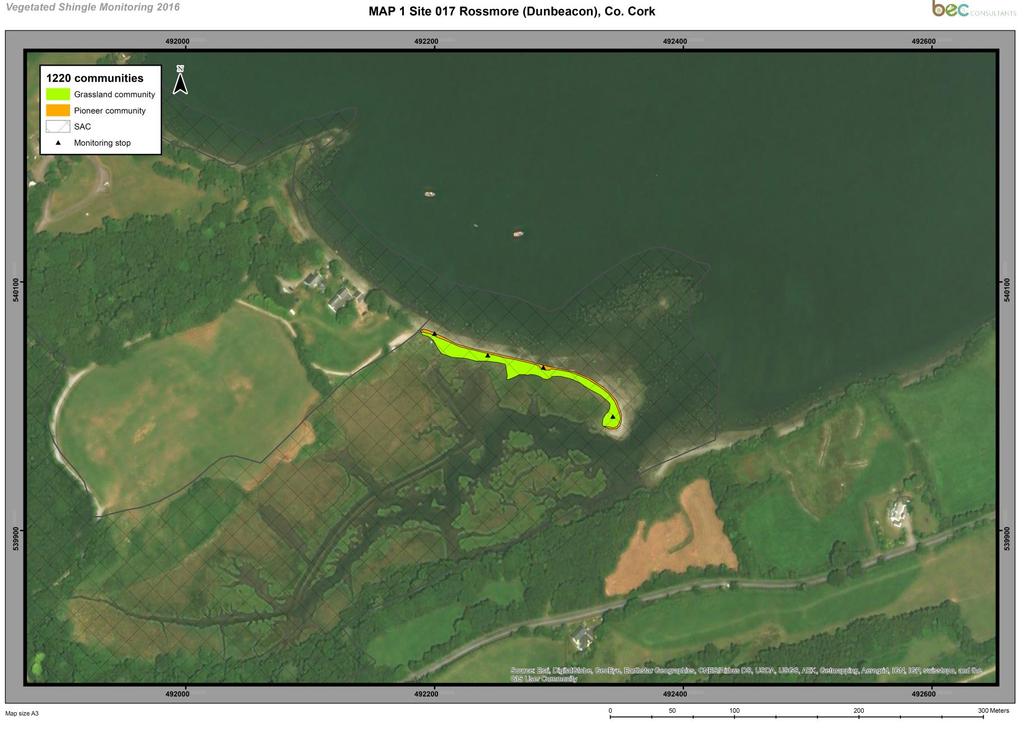
3 1 Introduction Achieving Favourable Conservation Status (FCS) is the overall objective to be reached for all Annex I habitat types and Annex II species of European Community interest listed in the Habitats Directive 92/43/EEC (European Commission, 2013). It is defined in positive terms such that a habitat type or species must be prospering and have good prospects of continuing to do so. Dunbeacon Shingle SAC is a small Special Area of Conservation (SAC) located approximately 3km southwest of Durrus, Co. Cork, on the southern side of Dunmanus Bay. Dunbeacon Shingle SAC (site code: ) is selected for 1220 Perennial vegetation of stony banks. The habitat is the sole Qualifying Interest for this SAC. The mapped distribution of perennial vegetation of stony banks in Dunbeacon Shingle SAC is presented in Appendix I. 2 Conservation Objectives A conservation objective aims to define the favourable conservation condition of a habitat or species at a particular site. Implementation of the objective will help to ensure that the habitat or species achieves favourable conservation status at a national level. This supporting document sets out the conservation objective for perennial vegetation of stony banks in Dunbeacon Shingle SAC, which is defined by a list of parameters, attributes and targets. The main parameters are (a) Range (b) Area and (c) Structure and Functions, the last of which is broken down into a number of attributes, including physical structure, vegetation structure and vegetation composition. The targets set for perennial vegetation of stony banks (vegetated shingle) are based in part on the findings of the Vegetated Shingle Monitoring Project (VSM) (Martin et al., 2017), which was carried out in 2016 on behalf of the National Parks and Wildlife Service (NPWS). This document should be read in conjunction with that report. Vegetated shingle within Dunbeacon Shingle SAC was also recorded during the National Shingle Beach Survey (NSBS), which was carried out in 1999 on behalf of NPWS (Moore and Wilson, 1999). The VSM surveyed, mapped and assessed a single sub-site associated with Dunbeacon Shingle SAC (Martin et al., 2017): Rossmore (Dunbeacon) (VSM site code 017) As part of the VSM, a detailed individual site report and a habitat map were produced for the Rossmore (Dunbeacon) sub-site and these are included in Appendix II at the end of this document. It is important to note, however, that other areas of the Annex I habitat may be present within the SAC. The conservation objective for perennial vegetation of stony banks in Dunbeacon Shingle SAC is based on the findings of the VSM. 2
4 3 Perennial vegetation of stony banks The following definition of perennial vegetation of stony banks habitat in Ireland is based on the data collected during the VSM (Martin et al., 2017) and is an adaptation of the definitions used in European Commission (2013) and NPWS (2013). Perennial vegetation of stony banks occurs along the coast where shingle (cobbles, pebbles, and gravel 2mm) has accumulated to form elevated ridges or banks above the high tide mark. The majority of the rocky material should be between 2mm and 256mm in diameter to be considered in this habitat category. On the upper beach, the pioneer community can be characterised by perennial species such as sea beet (Beta vulgaris subsp. maritima), sea-kale (Crambe maritima), rock samphire (Crithmum maritimum), cleavers (Galium aparine), yellow-horned poppy (Glaucium flavum), sea pea (Lathyrus japonicus), wild radish (Raphanus raphanistrum subsp. maritimus), curled dock (Rumex crispus), sea campion (Silene uniflora), perennial sow-thistle (Sonchus arvensis) and sea mayweed (Tripleurospermum maritimum). The majority of the area within this pioneer community is usually bare shingle. At the top of the beach, and moving inland, a wider range of vegetation types can be found at larger shingle sites including a lichen-rich community and coastal forms of grassland, heath and scrub. The grassland community can be characterised by grass species such as common bentgrass (Agrostis capillaris), creeping bent-grass (A. stolonifera), false oat-grass (Arrhenatherum elatius), cock s-foot (Dactylis glomerata), spreading meadow-grass (Poa humilis), sand couch (Elytrigia repens), red fescue (Festuca rubra), Yorkshire fog (Holcus lanatus) and crested hair-grass (Koeleria macrantha), field wood-rush (Luzula campestris), and broadleaf herbs such as yarrow (Achillea millefolium), thrift (Armeria maritima), common mouse-ear (Cerastium fontanum), wild carrot (Daucus carota), autumn hawkbit (Leontodon autumnalis), common bird s-foot trefoil (Lotus corniculatus), buck s-horn plantain (Plantago coronopus), ribwort plantain (P. lanceolata), silverweed (Potentilla anserina), common sorrel (Rumex acetosa), dandelion (Taraxacum officinale agg.), lady s bedstraw (Galium verum), red clover (Trifolium pratense) and white clover (T. repens). The scrub community can be characterised by the woody species honeysuckle (Lonicera periclymenum), blackthorn (Prunus spinosa), bramble (Rubus fruticosus agg.), gorse (Ulex europaeus) and the climber hedge bindweed (Calystegia sepium). These more inland communities have less bare shingle and vegetative cover usually dominates. The majority of the grassland and scrub communities are rooted within soil, whereas the pioneer community is usually rooted in gravel, sand or organic matter (e.g. decomposing seaweed and other plant material). Once the soil layer on top of the shingle is more than 30cm deep, the community is no longer defined as perennial vegetation of stony banks. 3.1 Overall Objective The overall objective for Perennial vegetation of stony banks in Dunbeacon Shingle SAC is to maintain the favourable conservation condition. This objective is based on an assessment of the recorded condition of the habitat under a range of attributes and targets. The assessment is divided into three main headings: (a) Range, (b) Area and (c) Structure and Functions. 3
5 3.2 Area Habitat area Habitat extent is a basic attribute to be assessed when determining the condition of a particular habitat. The target for favourable condition is that there is no decrease from the established baseline. Bearing in mind that coastal systems are naturally dynamic and subject to change, even within a season, this target is assessed subject to natural processes, including erosion and succession. The area of perennial vegetation of stony banks recorded by the VSM in the Rossmore (Dunbeacon) sub-site was 0.17ha (Martin et al., 2017). It is important to note that further areas of the habitat may be present within the SAC. The target is that the habitat area should be stable or increasing, subject to natural processes, including erosion and succession. 3.3 Range Habitat distribution The recorded location of the surveyed vegetated shingle site in Dunbeacon Shingle SAC, as mapped by Martin et al. (2017), is presented in Appendix I. The Rossmore (Dunbeacon) sub-site comprises a vegetated shingle spit (Martin et al., 2017). The NSBS (Moore and Wilson, 1999) classified the perennial vegetation of stony banks in the NSBS sub-site Rossmore as a vegetated shingle spit and it is defined as a spit following Chapman (1976). The NSBS (Moore and Wilson, 1999) ranked each surveyed site as either High, Medium or Low interest, based on site representativity, species diversity, habitat diversity and the presence of rare or scarce species. The Rossmore sub-site was ranked as a High interest site by the NSBS (Moore and Wilson, 1999) due to it being an excellent system and virtually undisturbed. A High interest ranking denoted a site that is of high conservation value and perhaps of interest botanically or geomorphologically (Moore and Wilson, 1999). It is important to note that further areas of the habitat may be present within the SAC. The target is that there should be no decline or change in the distribution of the habitat, unless it is the result of natural processes, including erosion and succession. 4
6 3.4 Structure and Functions A fundamental aim of shingle conservation is to facilitate natural mobility. Shingle beaches are naturally dynamic systems, making them of geomorphological interest, as well as ecological interest. They are constantly changing and shingle features are rarely stable in the long-term Physical structure: functionality and sediment supply The health and on-going development of the habitat relies on a continuing supply of shingle sediment. This may occur sporadically as a response to storm events rather than continuously. Interference with the natural coastal processes, through offshore (or onshore) extraction or coastal defence structures in particular, can interrupt the supply of sediment and lead to beach starvation. The shingle in the Rossmore (Dunbeacon) sub-site comprises cobble, pebble and gravel as defined using a modified version of the particle size ranges defined in Fossitt (2000). In the Rossmore (Dunbeacon) sub-site, gravel is the major component for stop 2, while pebble is the major component in stop 4 (Table 1). Table 1. Shingle composition (as defined in Fossitt (2000) with minor modifications) of perennial vegetation of stony banks in the Rossmore (Dunbeacon) sub-site during the VSM Percentage (%) cover shown, recorded to the nearest 5%. Only stops with exposed shingle could contribute to the data presented. Stop 2 Stop 4 Boulder (>256 mm) 0 0 Cobble (> mm) 0 30 Pebble (>16-64 mm) Gravel (2-16 mm) The target is to maintain, or where necessary restore, the natural circulation of sediment and organic matter, without any physical obstructions Physical structure: disturbance Damage to the habitat due to disturbance was assessed as a negative indicator by Martin et al. (2017). Disturbance can include damage from heavy trampling, vehicle damage and removal of substrate. The target is that no more than 20% of the habitat is affected by disturbance Vegetation structure: zonation Ecological variation within this habitat type depends on stability, the amount of fine material accumulating between the pebbles, climatic conditions, width of the foreshore and past management of the site. The ridges and lows also influence the vegetation patterns, resulting in characteristic communities and zonations of bare and vegetated shingle. In the frontal, less stable areas of shingle, the vegetation tends to be dominated by short-lived salt-tolerant perennials (pioneer community). Where the shingle is more stable, it becomes more vegetated and may include grassland, heathland and scrub communities, depending on the exact nature of the site. The 5
7 presence of lichens indicates long-term stability of the shingle structure. Further information on the communities of perennial vegetation of stony banks is found in Martin et al. (2017). The VSM (Martin et al., 2017) recorded two communities of perennial vegetation of stony banks in the Rossmore (Dunbeacon) sub-site - a pioneer community and a grassland community. The most abundant community was the grassland community, found towards the back of the system. Vegetated shingle is part of a naturally dynamic coastal system. In order to ensure the ecological functioning of all of the vegetated shingle communities present, it is vital to maintain the zonations and transitions to other habitats, including lagoon, saltmarsh and sand dune habitats. Transitions to intertidal and saltmarsh habitats occur in the Rossmore (Dunbeacon) sub-site. The target is to maintain the range of coastal habitats, including transitional zones, subject to natural processes, including erosion and succession Vegetation composition: communities and typical species The degree of exposure, as well as the coarseness and stability of the substrate, determines species diversity. Typical species lists for the three main vegetated shingle communities (pioneer, grassland and scrub) are presented in Martin et al. (2017). As mentioned earlier, the shingle in the Rossmore (Dunbeacon) sub-site includes two communities of perennial vegetation of stony banks that were recorded during the VSM (Martin et al., 2017) a pioneer and a grassland community. The grassland community is more extensive and runs the length of the shingle spit in the sub-site. The pioneer community is found fringing the grassland community around the periphery of the spit (Martin et al., 2017). Table 2 presents the typical species recorded within the pioneer and grassland communities of perennial vegetation of stony banks in the Rossmore (Dunbeacon) sub-site. Table 2. Typical species recorded within the pioneer and grassland communities of perennial vegetation of stony banks in the Rossmore (Dunbeacon) sub-site. Negative and non-native species are excluded from the list. Pioneer community Agrostis stolonifera Atriplex prostrata Beta vulgaris subsp. maritima Calystegia sepium Cochlearia officinalis Festuca rubra Fumaria capreolata Juncus gerardii Potentilla anserina Rumex crispus Sonchus arvensis Suaeda maritima Grassland community Agrostis stolonifera Atriplex prostrata Festuca rubra Lotus corniculatus Poa humilis Potentilla anserina Rumex crispus Silene uniflora Sonchus arvensis Trifolium repens Tripleurospermum maritimum No notable species or features were recorded in the Rossmore (Dunbeacon) sub-site during the VSM (Martin et al., 2017). 6
8 The target for this attribute is to ensure that the occurrence of typical species within the range of vegetated shingle communities is maintained Vegetation composition: negative indicator species Negative indicator species can include species indicative of changes in nutrient status e.g. nettle (Urtica dioica), and species not considered to be typical of the habitat, e.g. bracken (Pteridium aquilinum). The list of negative indicator species commonly found in the habitat is presented in Appendix I of Martin et al. (2017). The VSM (Martin et al., 2017) did not record any negative indicator species within the vegetated shingle habitat in the Rossmore (Dunbeacon) sub-site. The target for negative indicator species is that no species is present in more than 60% of stops and the combined cover in any individual stop is 25% or less Vegetation composition: non-native species Non-native species can be invasive and have deleterious effects on native vegetation. Low targets are set as non-native species can spread rapidly and are most easily dealt with when still at lower abundances. The VSM (Martin et al., 2017) did not record any non-native species within the vegetated shingle habitat in the Rossmore (Dunbeacon) sub-site. The target for non-native species is that no species is present in more than 20% of stops, the combined cover in any individual stop is 1% or less, and the cover across the whole site 1% or less. At a site level, if a non-native species has been under-recorded, or not recorded, via the stops the percentage cover for the species across the site should be recorded and assessed. 4 References Chapman, V.J. (1976) Coastal Vegetation. Pergamon Press, Oxford. European Commission (2013) Interpretation Manual of European Union Habitats EUR 28. DG Environment-Nature and Biodiversity, Brussels. Fossitt, J.A. (2000) A guide to habitats in Ireland. The Heritage Council, Kilkenny. Martin, J.R., Daly, O.H. and Devaney, F.M. (2017) Survey and assessment of vegetated shingle and associated habitats at 30 coastal sites in Ireland. Irish Wildlife Manuals, No. 98. National Parks and Wildlife Service, Department of Arts, Heritage, Regional, Rural and Gaeltacht Affairs, Dublin. Moore, D. and Wilson, F. (1999) National Shingle Beach Survey of Ireland Unpublished report to National Parks and Wildlife Service, Dublin. NPWS (2013) The status of EU protected habitats and species in Ireland. Volume 2. Habitat Assessments. Version 1.1. National Parks and Wildlife Service, Department of Arts, Heritage and the Gaeltacht, Dublin. 7

9 Appendix I Distribution map of perennial vegetation of stony banks within Dunbeacon Shingle SAC 8
10 Appendix II Rossmore (Dunbeacon) site report and habitat map from the Vegetated Shingle Monitoring Project (VSM) SITE 017 ROSSMORE (DUNBEACON) The following individual site report should be read in conjunction with the main report (Martin et al., 2017). Please note that NSBS refers to the National Shingle Beach Survey (NSBS) (Moore & Wilson, 1999), CMP refers to the Coastal Monitoring Project (Ryle et al., 2009), SDM refers to the Sand Dunes Monitoring Project (Delaney et al., 2013) and VSM to the Vegetated Shingle Monitoring Project (Martin et al., 2017). The shingle at this location is referred to as Site 110 Rossmore by the NSBS. 1 SITE DESCRIPTION Rossmore (Dunbeacon) is a small site located approximately 3 km southwest of Durrus, Co. Cork, on the southern side of Dunmanus Bay. Rossmore (Dunbeacon) is a vegetated shingle spit and is part of the Dunbeacon Shingle SAC (002280) (NPWS, 2014). This site was not surveyed by either the CMP or the SDM. It was, however, surveyed during the NSBS for the Annex I habitat 1220 Perennial vegetation of stony banks, though no conservation assessment was made. It was ranked as a High interest site by the NSBS due to it being an excellent system and virtually undisturbed. Annex I habitats associated with the 1220 Perennial vegetation of stony banks surveyed at Rossmore (Dunbeacon) include 1410 Mediterranean salt meadows (Juncetalia maritimae) (NPWS, 2015) that is present among the extensive area of saltmarsh on the landward side of the shingle habitat. No noteworthy species or features were recorded at Rossmore (Dunbeacon) during the VSM. Rossmore (Dunbeacon) is mainly used for fishing activities. 2 CONSERVATION ASSESSMENTS 2.1 Overview Rossmore (Dunbeacon) was surveyed on the 17th of August Perennial vegetation of stony banks was recorded during the NSBS, and again during the VSM. The 1220 Perennial vegetation of stony banks has two vegetation communities present - a pioneer community and a grassland community. The results of the conservation assessment of 1220 Perennial vegetation of stony banks are presented in Table 1. Table 1. Conservation assessment results for 1220 Perennial vegetation of stony banks surveyed at Rossmore (Dunbeacon), Co. Cork. Habitat Area Structure & Functions Future Prospects Overall result 1220 Perennial vegetation of stony banks Favourable Favourable Unfavourable -Inadequate Unfavourable -Inadequate Perennial vegetation of stony banks habitat assessment The conservation status of the Annex I habitat 1220 Perennial vegetation of stony banks at Rossmore (Dunbeacon) is discussed below. As this habitat was not previously assessed, no trend can be ascribed 9
11 to the conservation status. Areas recorded in 2016 are compared with the 1995 aerial photograph series. Due to the quality of these aerial photographs, only gross changes in area are noticeable. It should be borne in mind that natural processes such as erosion, deposition and succession are primary drivers of change on coastal habitats Area The area of each vegetation community of Annex I 1220 Perennial vegetation of stony banks is presented in Table 2. The grassland community is more extensive and runs the length of the shingle spit. The pioneer community is found fringing the grassland community around the periphery of the spit. Based on 1995 aerial photographs there has been no change in the proportion of vegetation communities of 1220 Perennial vegetation of stony banks at Rossmore (Dunbeacon), nor has there been any change in area of the habitat as a whole. It should be noted that due to the quality of the aerial photographs taken in 1995, only gross changes in area would be noticeable. Area was assessed as Favourable (stable) during the VSM. Table 2. Areas of the vegetation communities of Annex I 1220 Perennial vegetation of stony banks at Rossmore (Dunbeacon) based on aerial photographs (APs) from 1995 for baseline areas and areas mapped during the VSM. Habitat 1220 Perennial vegetation of stony banks 1995 APs (ha) Vegetated Shingle Monitoring Project (ha) Pioneer community Grassland community Total Structure and Functions Structure and Functions were assessed for 1220 Perennial vegetation of stony banks recorded at Rossmore (Dunbeacon) during the VSM. Table 3 shows the results of the Structure and Functions assessment. Table 3. Annex I 1220 Perennial vegetation of stony banks at Rossmore (Dunbeacon) for which Structure and Functions were assessed, with the number of monitoring stops, assessment criteria and the number of criteria that failed. Habitat No. monitoring stops Total no. assessment criteria No. failed criteria 1220 Perennial vegetation of stony banks Perennial vegetation of stony banks had none of its criteria fail. The coastal defences criterion was allowed to pass based on expert judgement as the area of coastal defences around the road and where the fishing equipment is stored on the shingle habitat is very small and at the periphery of the 1220 Perennial vegetation of stony banks. Structure and Functions of 1220 Perennial vegetation of stony banks were assessed as Favourable during the VSM Future Prospects Impacts and activities recorded at Rossmore (Dunbeacon) are presented in Table Impact codes are assigned according to Ssymank (2011). Three negative impacts were recorded as being present at Rossmore (Dunbeacon) during the VSM, though all only affected a small area of the 1220 Perennial 10
12 vegetation of stony banks. These included one high-intensity impact the storage of fishing equipment on the shingle, and tracks (medium intensity) and the presence of litter (low intensity). Coastal defences were recorded as a medium intensity neutral impact. There were no positive impacts recorded at Rossmore (Dunbeacon). Table 4. Impacts recorded in Annex I 1220 Perennial vegetation of stony banks at Rossmore (Dunbeacon) in Source refers to whether the impact being scored originates inside or outside the Annex I habitat being assessed. Habitat Impact Impact description Intensity Effect Percent Source code code of habitat 1220 D01.01 Paths, tracks, cycling tracks Medium Negative 1 Inside 1220 E05 Storage of materials (fishing equipment) High Negative 1 Inside 1220 H05.01 Garbage and solid waste Low Negative <1 Inside 1220 J Sea defence or coast protection works, tidal barrages Medium Neutral <1 Inside No impacts were recorded for 1220 Perennial vegetation of stony banks during the NSBS. Future prospects were assessed as Unfavourable-Inadequate during the VSM Conservation assessment Area and Structure and Functions were assessed as Favourable, while Future Prospects were assessed as Unfavourable-Inadequate. The conservation status of 1220 Perennial vegetation of stony banks at Rossmore (Dunbeacon) was assessed as Unfavourable-Inadequate. 3 DISCUSSION 3.1 Species lists for 1220 Perennial vegetation of stony banks communities Two communities of 1220 Perennial vegetation of stony banks were recorded during the VSM. Table 5 presents the positive indicator species recorded within the pioneer and grassland communities of 1220 Perennial vegetation of stony banks at Rossmore (Dunbeacon). Table 5. Positive indicator species recorded within the pioneer and grassland communities of 1220 Perennial vegetation of stony banks at Rossmore (Dunbeacon). Negative and non-native species are excluded from the list. Pioneer community Agrostis stolonifera Atriplex prostrata Beta vulgaris s. maritima Calystegia sepium Cochlearia officinalis Festuca rubra Fumaria capreolata Juncus gerardii Juncus species Potentilla anserina Rumex crispus Sonchus arvensis Suaeda maritima Grassland community Agrostis stolonifera Atriplex prostrata Festuca rubra Lotus corniculatus Poa humilis Potentilla anserina Rumex crispus Silene uniflora Sonchus arvensis Trifolium repens Tripleurospermum maritimum 11
13 3.2 Shingle vegetation substrate and composition The vegetation of the 1220 Perennial vegetation of stony banks grassland community is rooted within a soil substrate (stops 1 and 3), while the pioneer community vegetation is rooted within a gravel-soil mix for stop 2 and a sand-soil mix for stop 4. The shingle comprises cobble, pebble and gravel as defined using a modified version of the particle size ranges defined in Fossitt (2000). Gravel is the major component for stop 2, while pebble is the major component in stop 4 (Table 6). Table 6. Shingle composition (as defined in Fossitt (2000) with minor modifications) of 1220 Perennial vegetation of stony banks at Rossmore (Dunbeacon) during the VSM % cover shown, recorded to the nearest 5%. Only stops with exposed shingle could contribute to the data presented. Stop 2 Stop 4 Boulder (>256 mm) 0 0 Cobble (> mm) 0 30 Pebble (>16-64 mm) Gravel (2-16 mm) Stabilising effects of permanent structures Any anthropogenic structures which prevent the natural habitat migration of 1220 Perennial vegetation of stony banks must be looked upon unfavourably. There is a small area of 1220 Perennial vegetation of stony banks at Rossmore (Dunbeacon) which is impacted upon by coastal defences. These defences are artificially stabilising the spit and 1220 Perennial vegetation of stony banks habitat. Following the approach undertaken by the SDM most permanent built infrastructure, such as coastal defences and coastal roads, that were in place on the 1995 aerial photographs and had not undergone significant modifications or improvements since 1995 were scored as neutral. 3.4 Climate change Due to the extensive erosion of coastal systems within Ireland during the winter storms of 2013/14 and evidence that an increase in Atlantic storms over the last few decades could be due to climate change (Masselink et al., 2016), the impact of climate change on 1220 Perennial vegetation of stony banks should be assessed. Based on comparisons between the VSM mapping recorded in 2016 and aerial photography taken in 2010 it appears that the area of 1220 Perennial vegetation of stony banks at this site is unchanged and any impacts from storm activity have been minor. The impact of climate change has not been assessed for this site as it would be more appropriate if an assessment of this impact was made at the national level. 3.5 Other impacts Rossmore (Dunbeacon) is mainly utilised for fishing activities. The track into the west of the site facilitates access to fishing boats and the small area of coastal defences serves to stabilise the shingle in the vicinity of the track. The practice of storing fishing equipment on areas of the 1220 Perennial vegetation of stony banks should be stopped and fishermen should be made aware of the negative impacts of litter and rubbish at the site. 12
14 A site-specific management plan addressing the issues discussed in sections 3.3 and 3.5 would help improve the Future Prospects of 1220 Perennial vegetation of stony banks, and this would ultimately improve the overall conservation assessment for the habitat. 4 REFERENCES Delaney, A., Devaney, F.M, Martin, J.M. and Barron, S.J. (2013) Monitoring survey of Annex I sand dune habitats in Ireland. Irish Wildlife Manuals, No. 75. National Parks and Wildlife Service, Department of Arts, Heritage and the Gaeltacht, Dublin. Fossitt, J.A. (2000) A Guide to Habitats in Ireland. The Heritage Council, Kilkenny. Martin, J.R., Daly, O.H. and Devaney, F.M. (2017) Monitoring and assessment of EU Annex I habitat 1220 Perennial vegetation of stony banks at 30 sites. Irish Wildlife Manuals, No. 98. National Parks and Wildlife Service, Department of Arts, Heritage, Regional, Rural and Gaeltacht Affairs, Dublin. Masselink, G., Castelle, B., Scott, T., Dodet, G., Suanez, S., Jackson, D. and Floc, F. (2016) Extreme wave activity during 2013/2014 winter and morphological impacts along the Atlantic coast of Europe. Geophysical Research Letters 43: Moore, D. and Wilson, F. (1999) National Shingle Beach Survey of Ireland. Unpublished report to the National Parks and Wildlife Service, Dublin. NPWS (2014) SAC site synopsis for SAC Dunbeacon Shingle. National Parks and Wildlife Service, Department of Arts, Heritage and the Gaeltacht, Dublin. Accessed September NPWS (2015) Natura 2000 Standard Data Form, Site National Parks and Wildlife Service, Department of Arts, Heritage and the Gaeltacht, Dublin, Ireland. Accessed September Ryle, T., Murray, A., Connolly, K. and Swann, M. (2009) Coastal Monitoring Project A report submitted to the National Parks and Wildlife Service, Dublin. Ssymank, A. (2011) Reference list threats, pressures and activities (final version). ures_final_ xls. Accessed July
15 14
Ballinskelligs Bay and Inny Estuary SAC (site code 335) Conservation objectives supporting document -coastal habitats
 Conservation objectives supporting document -coastal habitats") Ballinskelligs Bay and Inny Estuary SAC (site code 335) Conservation objectives supporting document -coastal habitats NPWS Version 1 April 2014 Table of Contents Page No. 1 Introduction 2 2 Conservation
Ballinskelligs Bay and Inny Estuary SAC (site code 335) Conservation objectives supporting document -coastal habitats NPWS Version 1 April 2014 Table of Contents Page No. 1 Introduction 2 2 Conservation
National Parks and Wildlife Service
 ISSN 2009-4086 National Parks and Wildlife Service Conservation Objectives Series Kilpatrick Sandhills SAC 001742 Page 1 of 13 National Parks and Wildlife Service, Department of Arts, Heritage, Regional,
Appendix A.8.21 Lackagh Quarry Petrifying Spring Survey Results
 Appendix A.8.21 Lackagh Quarry Petrifying Spring Survey Results A.8.21 Lackagh Quarry Petrifying Spring Survey The results of the Petrifying spring survey at Lackagh Quarry are presented below in Table
Galway Bay Complex SAC (site code 268) Conservation objectives supporting document -coastal habitats
 Conservation objectives supporting document -coastal habitats") Galway Bay Complex SAC (site code 268) Conservation objectives supporting document -coastal habitats NPWS Version 1 January 2013 Table of Contents Page No. 1 Introduction 3 2 Conservation objectives 5
Galway Bay Complex SAC (site code 268) Conservation objectives supporting document -coastal habitats NPWS Version 1 January 2013 Table of Contents Page No. 1 Introduction 3 2 Conservation objectives 5
Bannow Bay SAC (site code 697) Conservation objectives supporting document -coastal habitats
 Conservation objectives supporting document -coastal habitats") Bannow Bay SAC (site code 697) Conservation objectives supporting document -coastal habitats NPWS Version 1 February 2012 Table of Contents Page No. 1 Introduction 3 2 Conservation objectives 5 3 Perennial
Bannow Bay SAC (site code 697) Conservation objectives supporting document -coastal habitats NPWS Version 1 February 2012 Table of Contents Page No. 1 Introduction 3 2 Conservation objectives 5 3 Perennial
Clew Bay SAC (site code 1482) Conservation objectives supporting document coastal habitats
 Conservation objectives supporting document coastal habitats") Clew Bay SAC (site code 1482) Conservation objectives supporting document coastal habitats NPWS Version 1 June 2011 Table of Contents Page No. 1 Introduction 3 2 Conservation objectives 5 3 Perennial vegetation
Clew Bay SAC (site code 1482) Conservation objectives supporting document coastal habitats NPWS Version 1 June 2011 Table of Contents Page No. 1 Introduction 3 2 Conservation objectives 5 3 Perennial vegetation
Tramore Dunes and Backstrand SAC (site code 671) Conservation objectives supporting document -coastal habitats
 Conservation objectives supporting document -coastal habitats") Tramore Dunes and Backstrand SAC (site code 671) Conservation objectives supporting document -coastal habitats NPWS Version 1 August 2013 Table of Contents Page No. 1 Introduction 3 2 Conservation objectives
Tramore Dunes and Backstrand SAC (site code 671) Conservation objectives supporting document -coastal habitats NPWS Version 1 August 2013 Table of Contents Page No. 1 Introduction 3 2 Conservation objectives
Dundalk Bay SAC (site code 455) Conservation objectives supporting document coastal habitats. Version 1
 Conservation objectives supporting document coastal habitats. Version 1") Dundalk Bay SAC (site code 455) Conservation objectives supporting document coastal habitats Version 1 March 2011 Table of Contents Page No. 1 Introduction 2 2 Conservation objectives 3 3 Perennial vegetation
Dundalk Bay SAC (site code 455) Conservation objectives supporting document coastal habitats Version 1 March 2011 Table of Contents Page No. 1 Introduction 2 2 Conservation objectives 3 3 Perennial vegetation
Inishmaan Island SAC (site code 212) Conservation objectives supporting document -coastal habitats
 Conservation objectives supporting document -coastal habitats") Inishmaan Island SAC (site code 212) Conservation objectives supporting document -coastal habitats NPWS Version 1 November 2014 Table of Contents Page No. 1 Introduction 3 2 Conservation objectives 5 3
Inishmaan Island SAC (site code 212) Conservation objectives supporting document -coastal habitats NPWS Version 1 November 2014 Table of Contents Page No. 1 Introduction 3 2 Conservation objectives 5 3
Appendix A.8.4 Galway City Transport Project Assessment of Annex I habitats in the Ballygarraun survey area (Perrin, 2014)
") Appendix A.8.4 Galway City Transport Project Assessment of Annex I habitats in the Ballygarraun survey area (Perrin, 2014) A.8.4 N6 Galway City Transport Project Assessment of Annex I habitats in the Ballygarraun
Appendix A.8.4 Galway City Transport Project Assessment of Annex I habitats in the Ballygarraun survey area (Perrin, 2014) A.8.4 N6 Galway City Transport Project Assessment of Annex I habitats in the Ballygarraun
BIOSPHERE. Vegetation plant succession Psammoseres sand dune successions
 Vegetation plant succession Psammoseres sand dune successions 1 What do you need to know? Evolution of vegetation communities to climax states Example: Coastal dune belts 2/3 examples of plants and their
National Parks and Wildlife Service
 ISSN 2009-4086 National Parks and Wildlife Service Conservation Objectives Series Barley Cove to Ballyrisode Point SAC 001040 Page 1 of 19 National Parks and Wildlife Service, Department of Arts, Heritage
Akeragh, Banna and Barrow Harbour SAC (site code: )
") NPWS Akeragh, Banna and Barrow Harbour SAC (site code: 000332) Conservation objectives supporting document- Coastal habitats Version 1 January 2017 Contents 1 Introduction... 3 2 Conservation Objectives...
NPWS Akeragh, Banna and Barrow Harbour SAC (site code: 000332) Conservation objectives supporting document- Coastal habitats Version 1 January 2017 Contents 1 Introduction... 3 2 Conservation Objectives...
Boyne Coast and Estuary SAC (site code 1957) Conservation objectives supporting document -coastal habitats
 Conservation objectives supporting document -coastal habitats") Boyne Coast and Estuary SAC (site code 1957) Conservation objectives supporting document -coastal habitats NPWS Version 1 August 2012 Table of Contents Page No. 1 Introduction 3 2 Conservation objectives
Boyne Coast and Estuary SAC (site code 1957) Conservation objectives supporting document -coastal habitats NPWS Version 1 August 2012 Table of Contents Page No. 1 Introduction 3 2 Conservation objectives
National Parks and Wildlife Service
 ISSN 2009-4086 National Parks and Wildlife Service Conservation Objectives Series Magherabeg Dunes SAC 001766 Page 1 of 14 National Parks and Wildlife Service, Department of Arts, Heritage, Regional, Rural
Cahore Polders and Dunes SAC (site code: )
") NPWS Cahore Polders and Dunes SAC (site code: 000700) Conservation objectives supporting document- Coastal habitats Version 1 December 2016 Contents 1 Introduction... 2 2 Conservation Objectives... 3 3
NPWS Cahore Polders and Dunes SAC (site code: 000700) Conservation objectives supporting document- Coastal habitats Version 1 December 2016 Contents 1 Introduction... 2 2 Conservation Objectives... 3 3
National Parks and Wildlife Service
 ISSN 2009 4086 National Parks and Wildlife Service Conservation Objectives Series Bannow Bay SAC 000697 Page 1 of 22 National Parks and Wildlife Service, Department of Arts, Heritage and the Gaeltacht,
Identifying faithful neighbours of rare plants in Britain; an application of the TPP dataset
 Identifying faithful neighbours of rare plants in Britain; an application of the TPP dataset Simon Smart (ssma@ceh.ac.uk), Kevin Walker, Peter Henrys, Oli Pescott, Rob Marrs Centre for Ecology & Hydrology,
Baldoyle Bay SAC (site code 199) Conservation objectives supporting document -coastal habitats
 Conservation objectives supporting document -coastal habitats") Baldoyle Bay SAC (site code 199) Conservation objectives supporting document -coastal habitats NPWS Version 1 November 2012 Table of Contents Page No. 1 Introduction 2 2 Conservation objectives 3 3 Saltmarsh
Baldoyle Bay SAC (site code 199) Conservation objectives supporting document -coastal habitats NPWS Version 1 November 2012 Table of Contents Page No. 1 Introduction 2 2 Conservation objectives 3 3 Saltmarsh
A revision of the Alopecurus pratensis - Sanguisorba officinalis (MG4) grassland community of the NVC 2014
 grassland community of the NVC 2014") A revision of the Alopecurus pratensis - Sanguisorba officinalis (MG4) grassland community of the NVC 2014 Mike Dodd Lowland floodplain meadows are recognised as a threatened habitat in the EU, being listed
A revision of the Alopecurus pratensis - Sanguisorba officinalis (MG4) grassland community of the NVC 2014 Mike Dodd Lowland floodplain meadows are recognised as a threatened habitat in the EU, being listed
Tranarossan and Melmore Lough SAC (site code 194) Conservation objectives supporting document -coastal habitats
 Conservation objectives supporting document -coastal habitats") Tranarossan and Melmore Lough SAC (site code 194) Conservation objectives supporting document -coastal habitats NPWS Version 1 April 2015 Table of Contents Page No. 1 Introduction 3 2 Conservation objectives
Tranarossan and Melmore Lough SAC (site code 194) Conservation objectives supporting document -coastal habitats NPWS Version 1 April 2015 Table of Contents Page No. 1 Introduction 3 2 Conservation objectives
20 Common Urban Plants in Ireland
 20 Common Urban Plants in Ireland Leaflet produced by Phoebe O'Brien based on species seen during a Heritage Week walk in August 2017 Annual Meadow-grass (Poa annua) The small Annual Meadow-grass has white
Mweelrea/Sheeffry/Erriff Complex SAC (site code: )
") NPWS Mweelrea/Sheeffry/Erriff Complex SAC (site code: 001932) Conservation objectives supporting document- Coastal habitats Version 1 July 2017 Contents 1 Introduction... 3 2 Conservation Objectives...
NPWS Mweelrea/Sheeffry/Erriff Complex SAC (site code: 001932) Conservation objectives supporting document- Coastal habitats Version 1 July 2017 Contents 1 Introduction... 3 2 Conservation Objectives...
Lackan Saltmarsh and Kilcummin Head SAC (site code: )
") NPWS Lackan Saltmarsh and Kilcummin Head SAC (site code: 000516) Conservation objectives supporting document- Coastal habitats Version 1 December 2016 Contents 1 Introduction... 3 2 Conservation Objectives...
NPWS Lackan Saltmarsh and Kilcummin Head SAC (site code: 000516) Conservation objectives supporting document- Coastal habitats Version 1 December 2016 Contents 1 Introduction... 3 2 Conservation Objectives...
Shoreline and Climate Change Adaptation Alternatives for The Letter Parcel, Bolinas Lagoon
 Shoreline and Climate Change Adaptation Alternatives for The Letter Parcel, Bolinas Lagoon Scenic shoreline vista of Bolinas Lagoon and ridges, from Letter Parcel, March 2016 Peter Baye, Coastal Ecologist
Salix are the UK s largest grower of native wetland and wildflowering plants in the UK.
 Habitat Plant Mixes: Salt Marsh Sand Dune Moorland Salix are the UK s largest grower of native wetland and wildflowering plants in the UK. In response to demand for a wider range of species for specific
Dune habitat conservation status assessment review
 Annotated document key - Item Summary Emphasis Dune habitat conservation status assessment review CCW carried out an assessment of the condition of the dune habitats of the SAC in the summer of 2005 and
St Mary s Churchyard, Potton
 2017 St Mary s Churchyard, Potton Laura Downton BCN Wildlife Trust September 2017 Grid Reference: SP 228 494 Date of visit: 8 th June 2017 Surveyor: Laura Downton from BCN Wildlife Trust 1. Site description
SIF_7.1_v2. Indicator. Measurement. What should the measurement tell us?
 Indicator 7 Area of natural and semi-natural habitat Measurement 7.1 Area of natural and semi-natural habitat What should the measurement tell us? Natural habitats are considered the land and water areas
Clare Island Cliffs SAC (site code: )
") NPWS Clare Island Cliffs SAC (site code: 002243) Conservation objectives supporting document- Coastal habitats Version 1 December 2016 Contents 1 Introduction... 2 2 Conservation Objectives... 3 3 Vegetated
NPWS Clare Island Cliffs SAC (site code: 002243) Conservation objectives supporting document- Coastal habitats Version 1 December 2016 Contents 1 Introduction... 2 2 Conservation Objectives... 3 3 Vegetated
Padgbury Lane South, Congleton REPTILE MITIGATION STRATEGY
 Padgbury Lane South, Congleton REPTILE MITIGATION STRATEGY February 2014 FPCR Environment and Design Ltd Registered Office: Lockington Hall, Lockington, Derby DE74 2RH Company No. 07128076. [T] 01509 672772
Raven Point Nature Reserve SAC (site code 710) Conservation objectives supporting document coastal habitats
 Conservation objectives supporting document coastal habitats") Raven Point Nature Reserve SAC (site code 710) Conservation objectives supporting document coastal habitats NPWS Version 1 October 2011 Table of Contents Page No. 1 Introduction 3 2 Conservation objectives
Raven Point Nature Reserve SAC (site code 710) Conservation objectives supporting document coastal habitats NPWS Version 1 October 2011 Table of Contents Page No. 1 Introduction 3 2 Conservation objectives
Biodiversity indicators for UK habitats: a process for determining species-weightings. Ed Rowe
 Biodiversity indicators for UK habitats: a process for determining species-weightings Ed Rowe Outline Progress with UK model chain What can our models predict? Why weight species? Alternative species weightings
National Parks and Wildlife Service
 ISSN 2009 4086 National Parks and Wildlife Service Conservation Objectives Series Slyne Head Islands SAC 000328 Page 1 of 8 National Parks and Wildlife Service, Department of Arts, Heritage and the Gaeltacht,
Record significant damage to vegetation by M. Alexander, E. Stubbings and B. Bueche
 Record significant damage to vegetation by M. Alexander, E. Stubbings and B. Bueche There have been a number of quite significant incidents when areas of coastal vegetation have been damaged. The worst
Cliff stabilisation. Adaptation Option Climate-ADAPT
 Cliff stabilisation Adaptation Option Climate-ADAPT Cover design: EEA Cover photo: EEA Layout: EEA Legal notice The contents of this publication do not necessarily reflect the official opinions of the
Quantifying effects of oil on coastal dune vegetation. Thomas Miller and Elise Gornish Biological Science, Florida State University
 Quantifying effects of oil on coastal dune vegetation Thomas Miller and Elise Gornish Biological Science, Florida State University Natural History of Barrier Islands in the Northern Gulf Make up ~70% of
Higher Geography Biosphere Vegetation Succession: Sand Dunes
 Higher Geography Biosphere Vegetation Succession: Sand Dunes A PowerPoint resource to accompany the posters available at: http://www.macaulay.ac.uk/soilposters/education_vegetation_6v2.pdf http://www.macaulay.ac.uk/soilposters/education_vegetation_7v2.pdf
Killala Bay/Moy Estuary SAC (site code 458) Conservation objectives supporting document -coastal habitats
 Conservation objectives supporting document -coastal habitats") Killala Bay/Moy Estuary SAC (site code 458) Conservation objectives supporting document -coastal habitats NPWS Version 1 August 2012 Table of Contents Page No. 1 Introduction 3 2 Conservation objectives
Killala Bay/Moy Estuary SAC (site code 458) Conservation objectives supporting document -coastal habitats NPWS Version 1 August 2012 Table of Contents Page No. 1 Introduction 3 2 Conservation objectives
Scenarios for the NI coast in the 21 st Century
 Scenarios for the NI coast in the 21 st Century Prof Julian Orford Geography, Archaeology & Palaeoecology Queen s University, Belfast Challenging perspective Living by the coast is good for your health!
Ballyness Bay SAC (site code 1090) Conservation objectives supporting document -coastal habitats
 Conservation objectives supporting document -coastal habitats") Ballyness Bay SAC (site code 1090) Conservation objectives supporting document -coastal habitats NPWS Version 1 March 2014 Table of Contents Page No. 1 Introduction 2 2 Conservation objectives 4 3 Sand
Ballyness Bay SAC (site code 1090) Conservation objectives supporting document -coastal habitats NPWS Version 1 March 2014 Table of Contents Page No. 1 Introduction 2 2 Conservation objectives 4 3 Sand
Coastal Environment. Introduction. 4.1 Coastal Environment. Extent of Coastal Environment
 4 The primary objective (set out in Chapter 2) to be implemented by this Chapter is Objective 2.4 ; the following objectives are also relevant due to the objectives integrated nature: 2.1 Tāngata whenua
North Dublin Bay SAC (site code 206) Conservation objectives supporting document -coastal habitats
 Conservation objectives supporting document -coastal habitats") North Dublin Bay SAC (site code 206) Conservation objectives supporting document -coastal habitats NPWS Version 1 October 2013 Table of Contents Page No. 1 Introduction 3 2 Conservation objectives 5 3
North Dublin Bay SAC (site code 206) Conservation objectives supporting document -coastal habitats NPWS Version 1 October 2013 Table of Contents Page No. 1 Introduction 3 2 Conservation objectives 5 3
AVON ESTUARY RESEARCH PROJECT SALT MARSH SURVEY
 Survey and Mapping AVON ESTUARY RESEARCH PROJECT SALT MARSH SURVEY For South Devon AONB Project: Client No: Atkins No: 5035211 Report Rev: 1 Date: September 2005 Avon Salt Marsh Report_.docx Page i Notice
Lower River Shannon SAC (site code 2165) Conservation objectives supporting document -coastal habitats
 Conservation objectives supporting document -coastal habitats") Lower River Shannon SAC (site code 2165) Conservation objectives supporting document -coastal habitats NPWS Version 1 May 2012 Table of Contents Page No. 1 Introduction 4 2 Conservation objectives 8 3
Lower River Shannon SAC (site code 2165) Conservation objectives supporting document -coastal habitats NPWS Version 1 May 2012 Table of Contents Page No. 1 Introduction 4 2 Conservation objectives 8 3
Karr J.R. and D.R. Dudley Ecological perspective on water quality goals. Environmental Manager 5:55-68.
 Ecological Integrity Assessment: An Approach for Assessing Ecosystem Condition to Guide Conservation and Management Ecological Integrity " the ability of an ecosystem to support and maintain i a balanced
Effect of competition on the distribution of Marram Grass within a sand dune system Introduction
 » sjhoward.co.uk Effect of competition on the distribution of Marram Grass within a sand dune system Introduction Sand dunes provide a classic example of the progression of ecological succession, with
Map Introduction: South Uist Map 1
 96 Map Introduction: Map This map section covers part of the south coast of, including the head of the causeway which links the island to Eriskay. It extends from South Glen Dale to Taobh a'caolas. There
Flamborough and Scarborough Coast. Project ID: LB12/ Maritime Cliff and Slope Vegetation Survey
 Flamborough and Scarborough Coast Project ID: LB12/13-182 Detailed SSSI Notification Review Submitted to: Natural England 4th Floor Foss House Kings Pool 1-2 Peasholme Green York YO1 7PX November 2012
Response to Section 92 RMA Request for Further Information - Donald Rodee, Matahui Peninsula -RM
 PO Box 364 Whakatane 3158 Attention: Jill Owen Dear Jill Response to Section 92 RMA Request for Further Information - Donald Rodee, Matahui Peninsula -RM16-0068 1 Introduction Donald Rodee ( the applicant
Chapter 7 Case study. Sand dune coastal environment: Studland Bay
 Sand dune coastal environment: Studland Bay Sand dunes are common features of low-lying stretches of coastline in the UK and elsewhere in the world. They form in places where there is a plentiful supply
Relatively little hard substrate occurs naturally in the
 CHAPTER FIVE Rock Habitats Relatively little hard substrate occurs naturally in the estuary, owing mainly to the vast quantities of fine sediment that have been deposited by the rivers. Rock habitat is
Study 11.9 Invasive Plant Study
 Initial Study Report Update Meeting Study 11.9 Invasive Plant Study March 29, 2016 Prepared by ABR, Inc. Environmental Research & Services 10/21/2014 1 Study 11.9 Status ISR documents (ISR Part D Overview):
Do Native Plant Mixtures Reduce Invasions Along Roadsides in Wisconsin? Joslyn Mink MS Candidate University of Wisconsin-Madison
 Do Native Plant Mixtures Reduce Invasions Along Roadsides in Wisconsin? Joslyn Mink MS Candidate University of Wisconsin-Madison Wisconsin Department of Transportation (DOT) Invasive plants perceived to
Natura 2000 in the marine environment: state of implementation and next steps
 Life on the blue planet: biodiversity research and the new European marine policies EPBRS European Platform on Biodiversity Research Strategy Porto, Portugal 7-9 November 2007 Natura 2000 in the marine
PURPOSE... i. Abbreviations... i. 1 Introduction Methods Compliance with Management Plans Results Discussion...
 PURPOSE... i Abbreviations... i 1 Introduction... 1 2 Methods... 3 3 Compliance with Management Plans... 5 4 Results... 6 5 Discussion... 8 6 Next Steps... 9 Appendix A... 1 Table 1 Flora monitoring
Alde-Ore Estuary Complex NVC 2013
 Improvement Programme for England s Natura 2000 Sites (IPENS) Planning for the Future IPENS012 Alde-Ore Estuary Comple NVC 2013 Appendi C: Vegetation species data per unit - Alde-Ore Estuary SSSI First
The integration of management and monitoring at Kenfig SAC. Clive Hurford
 The integration of management and monitoring at Kenfig SAC Clive Hurford Historic management issues at Kenfig Offshore dredging and intertidal sand extractions reduced the potential for sand accretion
Seaton to Seaton Hole SUMMARY OF PREFERRED PLAN RECOMMENDATIONS AND JUSTIFICATION
 Location reference: Policy Unit reference: Plan: Seaton to Seaton Hole 6a29 and 6a30 SUMMARY OF PREFERRED PLAN RECOMMENDATIONS AND JUSTIFICATION The large number of properties and assets at risk in the
Taunton River Salt Marsh Assessment Results from 2014 season
 Taunton River Salt Marsh Assessment Results from 2014 season December, 2014 During the late summer and fall of 2014, Save The Bay evaluated salt marshes in Assonet Bay, Freetown and Broad Cove in Dighton
The Coast: Beaches and Shoreline Processes
 1 2 3 4 5 6 7 8 9 The Coast: es and Shoreline Processes Trujillo & Thurman, Chapter 10 Oceanography 101 Chapter Objectives Recognize the various landforms characteristic of beaches and coastal regions.
The Coast: Beaches and Shoreline Processes Trujillo & Thurman, Chapter 10
 The Coast: es and Shoreline Processes Trujillo & Thurman, Chapter 10 Oceanography 101 Chapter Objectives Recognize the various landforms characteristic of beaches and coastal regions. Identify seasonal
Scotland s centre of expertise for waters. Dynamic Coast - National Coastal Change Assessment: Defence Asset Database
 Scotland s centre of expertise for waters Dynamic Coast - National Coastal Change Assessment: Defence Asset Database Scotland s centre of expertise for waters Published by CREW Scotland s Centre of Expertise
Phillip Island Nature Parks Coastal Process Study 8 October 2014
 Phillip Island Nature Parks Coastal Process Study 8 October 2014 Project Overview Coastal Geology Basaltic and fragmented lavas, granite at Pyramid Rock and Cape Woolamai Weathered basalt (>10m thick)
Annual transport rates at two locations on the fore-slope.
 Sediment Transport by Currents Fore-slope Sediment transport rates and sediment concentrations were computed from the hydrodynamic model runs as well as from direct measurements of current velocities at
Directorate E: Sectoral and regional statistics Unit E-4: Regional statistics and geographical information LUCAS 2018.
 EUROPEAN COMMISSION EUROSTAT Directorate E: Sectoral and regional statistics Unit E-4: Regional statistics and geographical information Doc. WG/LCU 52 LUCAS 2018 Eurostat Unit E4 Working Group for Land
PROJECT MONITORING PLAN
 Kent Island Vegetation Management PROJECT MONITORING PLAN Prepared for Marin County Open Space District Prepared by Prepared by Peter Baye PhD and William Carmen PhD October 18, 2012 Kent Island Restoration
Use of benthic invertebrate biological indicators in evaluating sediment deposition impairment on the Middle Truckee River, California
 Use of benthic invertebrate biological indicators in evaluating sediment deposition impairment on the Middle Truckee River, California David B. Herbst Sierra Nevada Aquatic Research Laboratory University
Contents. 1. Introduction 3 2. Saltmarsh in Halton 4 3. Survey 5 4. Results 6 5. Conclusion 11
 Contents 1. Introduction 3 2. Saltmarsh in Halton 4 3. Survey 5 4. Results 6 5. Conclusion 11 2 1. Introduction A saltmarsh occurs between the mean high water level of neap tides and the mean high water
A Natura 2000 Monitoring Framework Using Plant Species Gradients for Spectral Habitat Assessment
 A Natura 2000 Monitoring Framework Using Plant Species Gradients for Spectral Habitat Assessment Carsten Neumann, Gabriele Weiß, Sibylle Itzerott Department 1 Section 1.4 Döberitzer Heide ASD spectroradiometer
Restoration efforts required for achieving the objectives of the Birds and Habitats Directives
 In association with Restoration efforts required for achieving the objectives of the Birds and Habitats Directives Database notes and guidelines Prepared for the European Commission DG ENV Contents 1.
POLLINATOR HABITAT EVALUATION FORM
 POLLINATOR HABITAT EVALUATION FORM Evaluating habitat annually can help identify conditions and facilitate selection of management activities. Before you begin: STEP 1 Monitoring Record 1. Photocopy or
The Use of Geographic Information Systems to Assess Change in Salt Marsh Ecosystems Under Rising Sea Level Scenarios.
 The Use of Geographic Information Systems to Assess Change in Salt Marsh Ecosystems Under Rising Sea Level Scenarios Robert Hancock The ecological challenges presented by global climate change are vast,
16540/14 EE/cm 1 DG E 1A
 Council of the European Union Brussels, 5 December 2014 (OR. en) 16540/14 ENV 965 CULT 139 NOTE From: To: Subject: General Secretariat of the Council Delegations Charter of Rome on Natural and Cultural
An ecological basis for the management of grassland field margins
 Aspects of Applied Biology 108, 2011 Vegetation Management An ecological basis for the management of grassland field margins By S E SPRATT, A COOPER and T McCANN Environmental Sciences Research Institute,
Crustose algae communities on Baltic infralittoral rock and mixed substrata
 European Red List of Habitats Marine: Baltic Habitat Group Crustose algae communities on Baltic infralittoral rock and mixed substrata Summary This benthic habitat is present throughout the Baltic where
Ecosystems. Ecosystems at a local scale
 Ecosystems Ecosystems at a local scale Section outline Succession of one ecosystem The arresting role of physical factors in creating subclimax communities Role of human factors in maintaining plagioclimax
In-channel coarse sediment trap Best Management Practice
 In-channel coarse sediment trap Best Management Practice By Henry R. Hudson July 2002 Environmental Management Associates Ltd., Christchurch Complexity Environmental Value Cost Low Moderate High Low Moderate
Active Coastal Processes in the Lubec Embayment
 The Lubec Embayment Maine Geologic Facts and Localities August, 1998 Active Coastal Processes in the Lubec Embayment 44 49 50.51 N, 66 59 34.16 W Text by Joseph T. Kelley, Department of Agriculture, Conservation
4.2 Tidal Wetlands. Phragmites Australis
 4.2 Tidal Wetlands Few topics elicit such strong emotions in Guilford as the current state of salt marshes. These marshes, more broadly known as tidal wetlands, are undergoing a transformation as sea level
Bromyard Downs. Phase 1 Habitat Survey Report
 Bromyard Downs Phase 1 Habitat Survey Report Prepared by Catherine Coton and Ben Wood September 2014 Contents Introduction Page 3 Methodology Page 4 Phase 1 Habitats and descriptions in each management
Coastal Systems and Landscapes 3 days
 AS Level Geography WJEC Coastal Systems and Landscapes 3 days This course is for Welsh schools. This in-depth course prepares students for the physical fieldwork focusing on the Coastal option, for Section
Weathering of Rocks. Weathering - Breakdown of rocks into pieces (sediment) 2 main types of weathering to rocks
 2 main types of weathering to rocks") Weathering of Rocks Weathering - Breakdown of rocks into pieces (sediment) 2 main types of weathering to rocks Mechanical weathering requires physical forces to break rocks into smaller pieces. Chemical
Weathering of Rocks Weathering - Breakdown of rocks into pieces (sediment) 2 main types of weathering to rocks Mechanical weathering requires physical forces to break rocks into smaller pieces. Chemical
Roberts Wildflowers. A photographic guide to showy wildflowers of Roberts Regional Recreation Area. Sorted by Flower Color
 Roberts Wildflowers A photographic guide to showy wildflowers of Roberts Regional Recreation Area Sorted by Flower Color Photographs by Wilde Legard Botanist, East Bay Regional Park District Revision:
Appendix A.8.19 Habitat Survey Results - Species Lists
 Appendix A.8.19 Habitat Survey Results - Lists EIAR_Appendix A.8.19 A.8.19 This appendix presents the species lists for habitats recorded along, and adjacent to, the proposed road development. Section
Provisional revision of the MG4 Alopecurus pratensis - Sanguisorba officinalis community Hilary Wallace and Mike Prosser
 Provisional revision of the MG4 Alopecurus pratensis - Sanguisorba officinalis community Hilary Wallace and Mike Prosser Ecological Surveys (Bangor) and Floodplain Meadows Partnership (Open University)
Annual algae communities on Baltic infralittoral coarse sediment
 European Red List of Habitats Marine: Baltic Sea Habitat Group Annual algae communities on Baltic infralittoral coarse sediment Summary This habitat is found in all the Baltic Sea subbasins and is especially
Erosion Information Paper - South Naknek, Alaska Current as of November 14, 2007
 U.S. Army Corps of Engineers ALASKA BASELINE EROSION ASSESSMENT Erosion Information Paper - South Naknek, Alaska Current as of November 14, 2007 Community Information South Naknek (NACK-neck), originally
Vegetation Surveys (by Alice Hadley)
") Vegetation Surveys (by Alice Hadley) Background In 27 vegetation quadrats were set up of which 9 were made permanent. In 76 of these were resurveyed and 13 in 15. Due to time constraints and the fact that
Vegetation Surveys (by Alice Hadley) Background In 27 vegetation quadrats were set up of which 9 were made permanent. In 76 of these were resurveyed and 13 in 15. Due to time constraints and the fact that
Coastal Guide ICZM Information System
 Coastal Guide ICZM Information System 1. Key data Project title: Implementing alternative strategies in Irish beach and dune management: involvement in sustainable coastal development Country: Ireland
Shoreline Assessment Job Aid National Oceanic and Atmospheric Administration NOAA Ocean Service Office of Response and Restoration Hazardous
 Shoreline Assessment Job Aid National Oceanic and Atmospheric Administration NOAA Ocean Service Office of Response and Restoration Hazardous Materials Response Division This job aid was produced and published
Coastal issues: Beaches and Estuaries
 Coastal issues: Beaches and Estuaries Definitions: Coast = broad zone where both marine & terrestrial processes act It includes the beach, lagoons, marshes, bars etc. Coastal processes act to shape the
FIELD IDENTIFICATION: RYTON MEADOWS NATURE RESERVE
 CERTIFICATE IN ECOLOGY AND WILDLIFE CONSERVATION FIELD IDENTIFICATION: RYTON MEADOWS NATURE RESERVE JAYE WHALLEY 30 July 2008 Page 1 INTRODUCTION The location is Ryton Meadows Nature Reserve (Grid Ref:
Holderness Erosion and Evolution of the Spurn Peninsula
 Holderness Erosion and Evolution of the Spurn Peninsula Prof. Ken Pye and Dr. Simon Blott Kenneth Pye Associates Ltd. Outline of the Presentation Overview of historical erosion trends Effects of coast
Map 12: Ayrshire Coast: Doonfoot Beach to Dunure Map Content Descriptions
 Map 12: Ayrshire Coast: Doonfoot Beach to Dunure Map Content Descriptions 1. Built Heritage and Archaeology A total of twenty three sites were located in the area covered by Map 12. Of these seventeen
Introduction to Weed Science and Weed Identification
 Introduction to Weed Science and Weed Identification Definition of a Weed A plant growing where it is not wanted (Oxford Dictionary) Any plant or vegetation, excluding fungi, interfering with the objectives
Ecological networks and coherence according to article 10 of the Habitats Directive
 Ecological networks and coherence according to article 10 of the Habitats Directive Introduction Within the scientific community ecological coherence next to habitat quality has long been acknowledged
age 2 of 4 Bentley ond Grassland 19/08/2014 Survey Details Habitats ecorded National Vegetation Classifications MG7, Lolium perenne leys and related g
 age 1 of 4 Bentley ond Grassland 19/08/2014 Survey Summary Site Details Grid eference : SU78694409 ile eference : 74-0189 Total Area : 0.8 ha Civil arish : District : Vice-County : Survey Details Survey
Networking for Nature
 Networking for Nature A model for conservation monitoring and its practical application on Natura 2000 sites in Wales Clive Hurford Countryside Council for Wales Different types of investigation Natural