A Natura 2000 Monitoring Framework Using Plant Species Gradients for Spectral Habitat Assessment
|
|
|
- Dana Nelson
- 6 years ago
- Views:
Transcription


1 A Natura 2000 Monitoring Framework Using Plant Species Gradients for Spectral Habitat Assessment Carsten Neumann, Gabriele Weiß, Sibylle Itzerott Department 1 Section 1.4


2 Döberitzer Heide ASD spectroradiometer measurements x1 m & 2x2 m measurement area 81 areas for moist 72 for dry habitats floristic field surveys 1x1, 5x5, 30x30, 150x150, 60x240 m areas - species cover Braun-Blanquet - relevant parameters for nature conservation - structural plant- and population parameter Study Area & Sampling Design
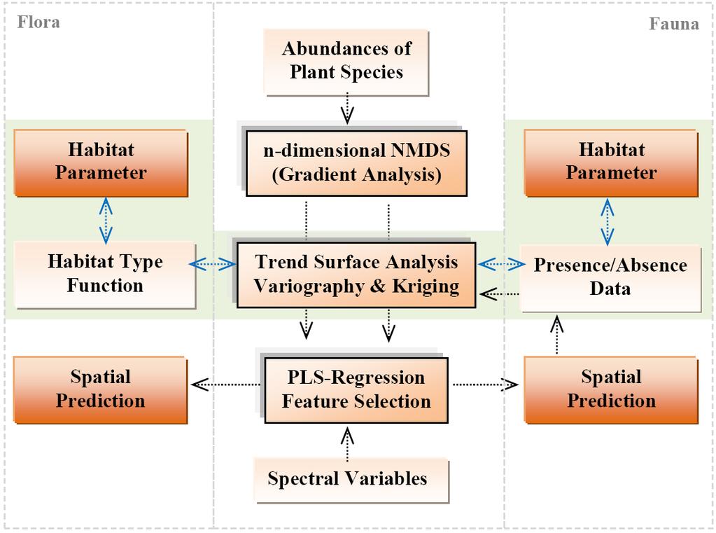
3 Monitoring Framework
 Corynephorus canescenz Arrhenatherum elatius Calamagrostis epigejos Calluna vulgaris Carex agg.")
4 Non-metric multidimensional scaling -> projecting samples x species matrix into 3D environmental space -> similarities (Bray-Curtis distance) are compared and differences between original & ordination are minimized -> an interpretation scheme is designed (colors for RGB space or Isosurfaces) Corynephorus canescenz Arrhenatherum elatius Calamagrostis epigejos Calluna vulgaris Carex agg. Molinia caerulea Environmental Space Modeling
5 variable aggregation within ordination space to derive FFH assessment parameter & habitat types -> dominance of character species -> species of disturbance -> developmental stage -> scrub/gras encroachment Is there a spatial variance structure that can predict species diversity within ordination space? Corynephorus canescenz (LRT 2330) Calluna vulgaris (LRT 4030) Festuca ovina agg. (LRT 6120) ordinated point cloud anisotropic correlation of a spatial stochastic variable Kriging Isosurface spatial correlation length spatial variance structure Habitat Parameter Aggregation

6 Definition of LRT specific Habitat Type functions -> functional relationship for quantitative determination of habitat types -> variable aggregation through adjustment of variables and parameter -> standardized linear combination translated to Occurrence Probabilities OP = [ a species A + b species B + ] - [ a disturb A + b disturb B + ] LRT 2330 open pioneer grassland Corynephorus canescenz 0.5 Bare ground 0.2 Cladonia spec. -> transition between probabilities < 50 % -> normalized inter habitat type transition strength Habitat Parameter Aggregation
 1.")

7 Definition of Intra Habitat Disturbance Species Complexes -> Habitat type specific disturbance functions are defined on the basis of known indicator species -> Disturbance strength is described by min-max normalized species cover for probabilities > 30 % LRT 2330 open pioneer grassland habitat encroachment a) 1.00 Cladonia spec Polytrichum piliferum b) 1.00 Polytrichum piliferum 0.99 Rubus caesius et fructicosus agg Rumex acetosella c) 1.00 Rumex acetosella 0.92 Agrostis capillaris 0.44 Calamagrostis epigejos -> Natura 2000 habitat assessment categories -> subtracting encroachment complexes from habitat type probabilities Habitat Parameter Aggregation
![PLS Regression between field spectra and score values of habitat type plots spectral model NMS1 spectral model NMS2 R² RMSE [%] n_c n_pred R² RMSE [%] n_c n_pred 0,491 21 2 147 0,827 10 2 142 0,820](/docs-images/75/71914288/images/8-5.jpg "12 2 68 0,130 20 2 61 0,789 12 2 9 0,854 10 2 14 external validation with terrestrial habitat type mapping and assessment occurrence probability assessment categories cor RMSE [%] cor RMSE [%] LRT")
8 PLS Regression between field spectra and score values of habitat type plots spectral model NMS1 spectral model NMS2 R² RMSE [%] n_c n_pred R² RMSE [%] n_c n_pred 0, , , , , , external validation with terrestrial habitat type mapping and assessment occurrence probability assessment categories cor RMSE [%] cor RMSE [%] LRT LRT LRT external validation with plant species assemblages on transect plots Spectral Modeling & Spatial Prediction

9 Example for predicted FFH-habitat types and assessment categories on a open dryland at the Döberitzer Heide Spatial Prediction

, sandy soils and dry")

10 Indicator species: Hipparchia statilinus Habitat characteristics -xerothermic areas -sun exposed -mosaic complexes with silver grass (corynephorus canescens), sandy soils and dry moss communities -interleaving with calluna-heath - Interleaving with Koeleria macrantha Species of Interest


11 -> August experts, students, interested people participated to map ~ 4000ha -> presence/absence data were collected in 13 sub-areas divided in 100 m² raster -> 65 Hipparchia statilinus & 242 Hipparchia semele were mapped Sampling Design
12 Spectral models RGB Composite Spectral models transferred to hyperspectral image signatures Spectral Modeling & Spatial Prediction

13 Habitat models in the environmental space -> presence/absence coordinates projected to ordination -> 3D Indicator Kriging -> Occurrence probabilities based on floristic composition 0 < 0.1 & 0.9 < 1 0 < 0.2 & 0.75 < 1 0 < 0.35 & 0.6 < 1 0 < 0.45 & 0.55 < 1 Occurrence Aggregation


14 1 2 3 RGB Composite 3D Kriging Cloud Spectral models transferred to hyperspectral image signatures Spectral Modeling & Spatial Prediction

15 Habitat parameter correlation and significance Habitat parameter visualization Habitat Parameter

16 Thank you for your attention! Department 1 Section 1.4
A Natura 2000 Monitoring Framework Using Plant Species Gradients for Spectral Habitat Assessment
 A Natura 2000 Monitoring Framework Using Plant Species Gradients for Spectral Habitat Assessment Carsten Neumann 1, Gabriele Weiss 2, Sibylle Itzerott 1 1 Helmholtz Centre Potsdam GFZ German Research Centre
PURPOSE... i. Abbreviations... i. 1 Introduction Methods Compliance with Management Plans Results Discussion...
 PURPOSE... i Abbreviations... i 1 Introduction... 1 2 Methods... 3 3 Compliance with Management Plans... 5 4 Results... 6 5 Discussion... 8 6 Next Steps... 9 Appendix A... 1 Table 1 Flora monitoring
Str. d. 17. Juni 145 (EB 5), Berlin, Germany; [michael.foerster], [christian.schuster],
![Str. d. 17. Juni 145 (EB 5), Berlin, Germany; [michael.foerster], [christian.schuster],](/thumbs/89/98813055.jpg "Str. d. 17. Juni 145 (EB 5), Berlin, Germany; [michael.foerster], [christian.schuster],") OBJECT-BASED CHANGE DETECTION ANALYSIS FOR THE MONITORING OF HABITATS IN THE FRAMEWORK OF THE NATURA 2000 DIRECTIVE WITH MULTI- TEMPORAL SATELLITE DATA M. Förster a, *, A. Frick b, C. Schuster a, B. Kleinschmit
OBJECT-BASED CHANGE DETECTION ANALYSIS FOR THE MONITORING OF HABITATS IN THE FRAMEWORK OF THE NATURA 2000 DIRECTIVE WITH MULTI- TEMPORAL SATELLITE DATA M. Förster a, *, A. Frick b, C. Schuster a, B. Kleinschmit
The integration of management and monitoring at Kenfig SAC. Clive Hurford
 The integration of management and monitoring at Kenfig SAC Clive Hurford Historic management issues at Kenfig Offshore dredging and intertidal sand extractions reduced the potential for sand accretion
Karr J.R. and D.R. Dudley Ecological perspective on water quality goals. Environmental Manager 5:55-68.
 Ecological Integrity Assessment: An Approach for Assessing Ecosystem Condition to Guide Conservation and Management Ecological Integrity " the ability of an ecosystem to support and maintain i a balanced
OBJECT BASED IMAGE ANALYSIS TO SUPPORT ENVIRONMENTAL MONITORING UNDER THE EUROPEAN HABITAT DIRECTIVE: A CASE STUDY FROM DECOVER
 OBJECT BASED IMAGE ANALYSIS TO SUPPORT ENVIRONMENTAL MONITORING UNDER THE EUROPEAN HABITAT DIRECTIVE: A CASE STUDY FROM DECOVER O.Buck a, *, B.Peter a, A.Völker a, A.Donning a a EFTAS Remote Sensing GmbH,
Favourable Condition of Blanket Bog on Peak District SSSIs. Richard Pollitt Lead Adviser, Conservation & Land Management, Dark and South West Peak
 Favourable Condition of Blanket Bog on Peak District SSSIs Richard Pollitt Lead Adviser, Conservation & Land Management, Dark and South West Peak Definitions SSSI Site of Special Scientific Interest statutory
Directions: Using the Succession Power Point, answer the following questions. 1. What did these events do to the earth? 2. How did the events do this?
 Name Period Date Assigned Date Due Date Returned Directions: Using the Succession Power Point, answer the following questions. 1. What did these events do to the earth? 2. How did the events do this? 3.
Digital and real-habitat modeling of Hipparchia statilinus based on hyper spectral remote sensing data
 Int. J. Environ. Sci. Technol. (2016) 13:187 200 DOI 10.1007/s13762-015-0859-1 ORIGINAL PAPER Digital and real-habitat modeling of Hipparchia statilinus based on hyper spectral remote sensing data L. Luft
Managing uncertainty when aggregating from pixels to parcels: context sensitive mapping and possibility theory
 Department of Geography Managing uncertainty when aggregating from pixels to parcels: context sensitive mapping and possibility theory Dr Lex Comber ajc36@le.ac.uk www.le.ac.uk/gg/staff/academic_comber.htm
BIO 682 Multivariate Statistics Spring 2008
 BIO 682 Multivariate Statistics Spring 2008 Steve Shuster http://www4.nau.edu/shustercourses/bio682/index.htm Lecture 11 Properties of Community Data Gauch 1982, Causton 1988, Jongman 1995 a. Qualitative:
From SARA (Germany)*) (= Satellitengestütztes Raummonitoring) to SASMO**) (=Satellite based spatial monitoring for Europe)
*) (= Satellitengestütztes Raummonitoring) to SASMO**) (=Satellite based spatial monitoring for Europe)") From SARA (Germany)*) (= Satellitengestütztes Raummonitoring) to SASMO**) (=Satellite based spatial monitoring for Europe) *) This cooperative project, funded by the Brandenburg Ministry for Economic Affairswas
From SARA (Germany)*) (= Satellitengestütztes Raummonitoring) to SASMO**) (=Satellite based spatial monitoring for Europe) *) This cooperative project, funded by the Brandenburg Ministry for Economic Affairswas
Identifying faithful neighbours of rare plants in Britain; an application of the TPP dataset
 Identifying faithful neighbours of rare plants in Britain; an application of the TPP dataset Simon Smart (ssma@ceh.ac.uk), Kevin Walker, Peter Henrys, Oli Pescott, Rob Marrs Centre for Ecology & Hydrology,
RESTORING ACTIVE BLANKET BOG IN IRELAND Project reference: LIFE02NAT/IRL/8490
 Page 1 of 34 RESTORING ACTIVE BLANKET BOG IN IRELAND Project reference: LIFE02NAT/IRL/8490 A REPORT ON THE RESTORATION OF PROJECT SITE No. 13. CROAGHONAGH, CO. DONEGAL. Compiled by: John Conaghan 11 Dun
USING HYPERSPECTRAL IMAGERY
 USING HYPERSPECTRAL IMAGERY AND LIDAR DATA TO DETECT PLANT INVASIONS 2016 ESRI CANADA SCHOLARSHIP APPLICATION CURTIS CHANCE M.SC. CANDIDATE FACULTY OF FORESTRY UNIVERSITY OF BRITISH COLUMBIA CURTIS.CHANCE@ALUMNI.UBC.CA
6. Hvad sker der, når Rosa rugosa breder sig?
 6. Hvad sker der, når Rosa rugosa breder sig? 6.1 Impact of Rosa rugosa on dune ecosytems at the German North Sea coast - in comparison with Hippophaë rhamnoides By Maike Isermann, University of Bremen,
The game changer for biodiversity? Mapping and monitoring invasive plants, floristic gradients and ecosystem properties using Sentinel-2
 The game changer for biodiversity? Mapping and monitoring invasive plants, floristic gradients and ecosystem properties using Sentinel-2 Van De Kerchove Ruben Marcel Buchhorn, Els Knaeps, Luc Bertels (VITO)
The Norwegian monitoring program for sub-alpine birch-forests
 The Norwegian monitoring program for sub-alpine birch-forests Effects of air pollution and climate change on ground vegetation Vegar Bakkestuen & Per Arild Aarrestad Norwegian sub-alpine birch-forests
Stamp Area. Biology - Note Packet #55. Major Climate Change ( ) What are some causes of major changes (or disruptions) in an ecosystem?
 What are some causes of major changes (or disruptions) in an ecosystem?") Name: Mr. LaFranca s - Period Date: Aim: How do ecosystems change over time? Do Now: In I Am Legend, Will Smith s character is the last man in an abandoned NYC. Why do you think grass is overtaking (growing
Name: Mr. LaFranca s - Period Date: Aim: How do ecosystems change over time? Do Now: In I Am Legend, Will Smith s character is the last man in an abandoned NYC. Why do you think grass is overtaking (growing
A.6. Kooistra, L., Mücher, C.A., Chan, J.C.W., Van den Borre, J. and Haest, B. (2009). Use of spectral mixture analysis for characterisation of
. Use of spectral mixture analysis for characterisation of") A.6. Kooistra, L., Mücher, C.A., Chan, J.C.W., Van den Borre, J. and Haest, B. (2009). Use of spectral mixture analysis for characterisation of function and structure of heathland habitat types. Paper
A.6. Kooistra, L., Mücher, C.A., Chan, J.C.W., Van den Borre, J. and Haest, B. (2009). Use of spectral mixture analysis for characterisation of function and structure of heathland habitat types. Paper
Global Biogeography. Natural Vegetation. Structure and Life-Forms of Plants. Terrestrial Ecosystems-The Biomes
 Global Biogeography Natural Vegetation Structure and Life-Forms of Plants Terrestrial Ecosystems-The Biomes Natural Vegetation natural vegetation is the plant cover that develops with little or no human
North Lowther Energy Initiative National Vegetation Classification Survey Report Technical Appendix 8.1
 Document Quality Record Version Status Person Responsible Date 1 Draft Brian Henry 19/09/2016 2 Reviewed Rafe Dewar 21/09/2016 3 Updated Brian Henry 21/09/2016 4 Internal Approval Brian Henry 08/03/2017
Chapter 1 - Lecture 3 Measures of Location
 Chapter 1 - Lecture 3 of Location August 31st, 2009 Chapter 1 - Lecture 3 of Location General Types of measures Median Skewness Chapter 1 - Lecture 3 of Location Outline General Types of measures What
Categorizing Grassland Vegetation with Full-Waveform Airborne Laser Scanning: A Feasibility Study for Detecting Natura 2000 Habitat Types
 Remote Sens. 2014, 6, 8056-8087; doi:10.3390/rs6098056 Article OPEN ACCESS remote sensing ISSN 2072-4292 www.mdpi.com/journal/remotesensing Categorizing Grassland Vegetation with Full-Waveform Airborne
Appendix A.8.4 Galway City Transport Project Assessment of Annex I habitats in the Ballygarraun survey area (Perrin, 2014)
") Appendix A.8.4 Galway City Transport Project Assessment of Annex I habitats in the Ballygarraun survey area (Perrin, 2014) A.8.4 N6 Galway City Transport Project Assessment of Annex I habitats in the Ballygarraun
Appendix A.8.4 Galway City Transport Project Assessment of Annex I habitats in the Ballygarraun survey area (Perrin, 2014) A.8.4 N6 Galway City Transport Project Assessment of Annex I habitats in the Ballygarraun
THE WITHIN POPULATION VARIANCE IN GENECOLOGICAL TRIALS
 THE WITHIN POPULATION VARIANCE IN GENECOLOGICAL TRIALS BY D. J. HARBERD Scottish Plant Breeding Station, Pentlandfield, Rosliu, Midlothian (Received 21 September 1956) (With I figure in the text) INTRODUCTION
5 MAPPING VEGETATION TYPES IN AN ALPINE AREA USING VEGETATION OBSERVATIONS AND DERIVATIVES OF A DIGITAL ELEVATION MODEL
 5 MAPPING VEGETATION TYPES IN AN ALPINE AREA USING VEGETATION OBSERVATIONS AND DERIVATIVES OF A DIGITAL ELEVATION MODEL Karin Pfeffer, Edzer J.Pebesma and Peter A. Burrough Submitted to Landscape Ecology
OBJECT IDENTIFICATION AND CHARACTERIZATION WITH HYPERSPECTRAL IMAGERY TO IDENTIFY STRUCTURE AND FUNCTION OF NATURA 2000 HABITATS
 OBJECT IDENTIFICATION AND CHARACTERIZATION WITH HYPERSPECTRAL IMAGERY TO IDENTIFY STRUCTURE AND FUNCTION OF NATURA 2000 HABITATS C.A. Mücher a, L. Kooistra b, M. Vermeulen b, B. Haest c, T. Spanhove d,
The diet of field voles Microtus agrestis at low population density in upland Britain
 Acta Theriologica 50 (4): 483 492, 2005. PL ISSN 0001 7051 The diet of field voles Microtus agrestis at low population density in upland Britain Philip WHEELER* Wheeler P. 2005. The diet of field voles
Development of a nitrophobe/nitrophile classification for woodlands, grasslands and upland vegetation in Scotland.
 Development of a nitrophobe/nitrophile classification for woodlands, grasslands and upland vegetation in Scotland. Carole Pitcairn, Ian Leith, Lucy Sheppard and Mark Sutton Centre for Ecology and Hydrology
Beach and Dune Plant Associations of British Columbia
 Beach and Dune Plant Associations of British Columbia Nick Page Raincoast Applied Ecology (January 2007 Draft) 1a. Cakile edentula Sparse 1a. Cakile edentula Sparse a b 2a. Leymus mollis Achillea millefolium
Floristic Quality Index: Current Methods and Development. Nia Wellendorf Russ Frydenborg DEP Bureau of Labs
 Floristic Quality Index: Current Methods and Development Nia Wellendorf Russ Frydenborg DEP Bureau of Labs Outline History and definition of FQI Methods developed for Florida lakes Ongoing index development
Biodiversity indicators for UK habitats: a process for determining species-weightings. Ed Rowe
 Biodiversity indicators for UK habitats: a process for determining species-weightings Ed Rowe Outline Progress with UK model chain What can our models predict? Why weight species? Alternative species weightings
Habits and Habitats 4 th 5 th Grade Lesson Plan
 Habits and Habitats 4 th 5 th Grade Lesson Plan For more information, please contact: Janice Kerber Director of Education John D. MacArthur Beach State Park T: (561) 776-7449 Ext 104 Email: janicekerber@macarthurbeach.org
Chapter 3 Populations and interactions
 Chapter 3 Populations and interactions Worksheet 1: Definitions Worksheet 2: Succession *Practical 1: Investigating the distribution of plants using random sampling *Practical 2: Investigating the distribution
Varying diversity patterns of vascular plants, bryophytes, and lichens at different spatial scales in central European landscapes
 Varying diversity patterns of vascular plants, bryophytes, and lichens at different spatial scales in central European landscapes Jürgen DENGLER, University of Hamburg & Marc-André ALLERS, ETH Zurich Contents
Networking for Nature
 Networking for Nature A model for conservation monitoring and its practical application on Natura 2000 sites in Wales Clive Hurford Countryside Council for Wales Different types of investigation Natural
3 Communities, Biomes, and Ecosystems BIGIDEA Write the Big Idea for this chapter.
 3 Communities, Biomes, and Ecosystems BIGIDEA Write the Big Idea for this chapter. Use the What I Know column to list the things you know about the Big Idea. Then list the questions you have about the
ECOFACT Volume 1. The main objectives of the work which produced the present book were therefore:
 ECOFACT Volume 1 Introduction and Approach: Introduction The vegetation and land cover of the British countryside were surveyed in 199 by the Institute of Terrestrial Ecology under a contract from the
REGIONAL MAPPING OF PLANT FUNCTIONAL TYPES IN RIVER FLOODPLAIN ECOSYSTEMS USING AIRBORNE IMAGING SPECTROSCOPY DATA
 REGIONAL MAPPING OF PLANT FUNCTIONAL TYPES IN RIVER FLOODPLAIN ECOSYSTEMS USING AIRBORNE IMAGING SPECTROSCOPY DATA L. Kooistra *, L. Sanchez-Prieto, H.M. Bartholomeus, M.E. Schaepman Wageningen University,
Biomes Section 1. Chapter 6: Biomes Section 1: What is a Biome? DAY ONE
 Chapter 6: Biomes Section 1: What is a Biome? DAY ONE What is a Biome? Biomes are large regions characterized by a specific type of climate and certain types of plant and animal communities. The climate
Introduction to multivariate analysis Outline
 Introduction to multivariate analysis Outline Why do a multivariate analysis Ordination, classification, model fitting Principal component analysis Discriminant analysis, quickly Species presence/absence
Pattern and process in coastal dune. vegetations. community is considered as a fundamental object of ecological study. Coastal
 (cf. bandwidth Pattern and process in coastal dune vegetations C.G. van Leeuwen ande. van der Maarel Botanisch Laboratorium, Universiteit, Nijmegen, and RIN Zeist. Mededelingnr. 10 van bet Rijksinstituut
NONLINEAR REDUNDANCY ANALYSIS AND CANONICAL CORRESPONDENCE ANALYSIS BASED ON POLYNOMIAL REGRESSION
 Ecology, 8(4),, pp. 4 by the Ecological Society of America NONLINEAR REDUNDANCY ANALYSIS AND CANONICAL CORRESPONDENCE ANALYSIS BASED ON POLYNOMIAL REGRESSION VLADIMIR MAKARENKOV, AND PIERRE LEGENDRE, Département
Environmental Science
 Environmental Science A Study of Interrelationships Cui Jiansheng Hebei University of Science and Technology CH06 Kinds of Ecosystems and Communities Chapter Objectives After reading this chapter, you
Climate Change & Alpine Plants:
 Climate Change & Alpine Plants: Effects of temperature and precipitation on alpine grasslands Western Norway Pascale Michel*, Vigdis Vandvik, Olav Skarpaas, Kari Klanderud * Ecology and Environmental Change
LAND USE MAPPING FOR CONSTRUCTION SITES
 LAND USE MAPPING FOR CONSTRUCTION SITES STATEMENT OF THE PROBLEM Monitoring of existing construction sites within the limits of the City of Columbia is a requirement of the city government for: 1) Control
Bivariate data analysis
 Bivariate data analysis Categorical data - creating data set Upload the following data set to R Commander sex female male male male male female female male female female eye black black blue green green
Environmental Statement South Kyle Wind Farm August Appendix 12.9: The Habitat Loss and Disturbance Calculations
 Appendix 12.9: The Habitat and Disturbance Calculations 1.1 Introduction 1 This appendix details the approach, assumptions and results of the process adopted to quantify habitat loss and degradation as
The World of Lichens Part of: Joint Science Education Project at Dartmouth Developed by: Ruth Heindel, Earth Sciences Department, Dartmouth College
 The World of Lichens Part of: Joint Science Education Project at Dartmouth Developed by: Ruth Heindel, Earth Sciences Department, Dartmouth College Overview Lichens are incredible symbiotic organisms that
Summary Visualizations for Coastal Spatial Temporal Dynamics
 Summary Visualizations for Coastal Spatial Temporal Dynamics October 24 2011 Providence, RI Sidharth Thakur 1, Laura Tateosian 2, Helena Mitasova, Eric Hardin, and Margery Overton 1. sthakur@renci.org,
Classification of Plant Communities
 1 Module # 12 Component # 2 Objective Understand the function that plant communities and vegetation units have in drawing up a wildlife management plan, and to understand the methods associated with the
Ecology. Ecology terminology Biomes Succession Energy flow in ecosystems Loss of energy in a food chain
 Ecology Ecology terminology Biomes Succession Energy flow in ecosystems Loss of energy in a food chain Terminology Ecology- the study of the interactions of living organisms with one another and with their
Ecological Succession
 Ecological Succession Primary succession will ALWAYS be on areas where there is NO SOIL a) bare rock from a retreating glacier, b) newly cooled lava; c) abandoned lot with an impervious surface (parking
Ecology for Planting Design - understanding long-term plant performance. (C) Noel Kingsbury 2016
 Noel Kingsbury 2016") Ecology for Planting Design - understanding long-term plant performance (C) Noel Kingsbury 2016 Understanding plants as living materials Inherently less predictable than hard materials Need to understand,
Ecology for Planting Design - understanding long-term plant performance (C) Noel Kingsbury 2016 Understanding plants as living materials Inherently less predictable than hard materials Need to understand,
Background information of groundwater dependent ecosystems (GDE) on Estonian Gauja-Koiva river basin
 on Estonian Gauja-Koiva river basin") Background information of groundwater dependent ecosystems (GDE) on Estonian Gauja-Koiva river basin Elve Lode & Martin Küttim Content Some facts about the Koiva river Something about GDEs Ecological data
Background information of groundwater dependent ecosystems (GDE) on Estonian Gauja-Koiva river basin Elve Lode & Martin Küttim Content Some facts about the Koiva river Something about GDEs Ecological data
Inland dunes in the Netherlands: soil, vegetation, nitrogen deposition and invasive species Sparrius, L.B.
 UvA-DARE (Digital Academic Repository) Inland dunes in the Netherlands: soil, vegetation, nitrogen deposition and invasive species Sparrius, L.B. Link to publication Citation for published version (APA):
Orchids: Where is my home?
 Orchids: Where is my home? Introduction Orchids can grow in a variety of habitats such as marshes and wetlands, on trees, in the ground, on cliffs, riverbanks and areas where decaying organic matter and
Rose, F. (1989) Grasses, sedges, rushes and ferns of the British Isles and north-western Europe. Viking
 Grasses, sedges, rushes and ferns of the British Isles and north-western Europe. Viking") The diversity of grasslands is often based on the presence of flowering plants and grasses. National Vegetation Classification (NVC) is a survey method that helps to identify the community of plants in
The diversity of grasslands is often based on the presence of flowering plants and grasses. National Vegetation Classification (NVC) is a survey method that helps to identify the community of plants in
Each copy of any part of a JSTOR transmission must contain the same copyright notice that appears on the screen or printed page of such transmission.
 !"#$%&'()'*$,-./'$.'1&"(2#34-%'5-&(/4.'64#(2-&-(.'(.'&34'74/4&$&-(.'()'68'9($2&$: 6;.4'*$22:$.2 1;&3('?$&&3-@2'AB'&4.'C$D4:'$.'E$.D'F$.'4'?4;:4. G(;%4>'A(;.$:'()'74/4&$&-(.'G%-4.%4H'7(:B'IH'5(B'J'
Earth s Major Terrerstrial Biomes. *Wetlands (found all over Earth)
") Biomes Biome: the major types of terrestrial ecosystems determined primarily by climate 2 main factors: Depends on ; proximity to ocean; and air and ocean circulation patterns Similar traits of plants
Biomes Biome: the major types of terrestrial ecosystems determined primarily by climate 2 main factors: Depends on ; proximity to ocean; and air and ocean circulation patterns Similar traits of plants
Welcome! Text: Community Ecology by Peter J. Morin, Blackwell Science ISBN (required) Topics covered: Date Topic Reading
 Topics covered: Date Topic Reading") Welcome! Text: Community Ecology by Peter J. Morin, Blackwell Science ISBN 0-86542-350-4 (required) Topics covered: Date Topic Reading 1 Sept Syllabus, project, Ch1, Ch2 Communities 8 Sept Competition
Welcome! Text: Community Ecology by Peter J. Morin, Blackwell Science ISBN 0-86542-350-4 (required) Topics covered: Date Topic Reading 1 Sept Syllabus, project, Ch1, Ch2 Communities 8 Sept Competition
Measuring Diversity in Plant Communities with Mosaic Spatial Patterns: Danish Coastal Dunes
 10 The Open Ecology Journal, 2011, 4, 1017 Open Access Measuring Diversity in Plant Communities with Mosaic Spatial Patterns: Danish Coastal Dunes Christian Damgaard *,1, Bettina Nygaard 2, Knud Erik Nielsen
Pebbles, Sand and Silt Storyline
 Pebbles, Sand and Silt Storyline Prepared Graduate Competency Evaluate evidence that Earth s geopshere, atmosphere, hydrosphere and biosphere interact as a complex system. Big Idea Earth is a system that
Multivariate Analysis of Ecological Data using CANOCO
 Multivariate Analysis of Ecological Data using CANOCO JAN LEPS University of South Bohemia, and Czech Academy of Sciences, Czech Republic Universitats- uric! Lanttesbibiiothek Darmstadt Bibliothek Biologie
VALERI-2001 CAMPAIGN IN GOURMA (MALI)
") VALERI-2001 CAMPAIGN IN GOURMA (MALI) Participants: Mougin Eric (CESBIO), Fadiala Dembélé (IER), Hiernaux Pierre (ILRI) September 28 October 6, 2001 2 VALERI-2001 CAMPAIGN IN GOURMA (MALI) Due to administrative
VALERI-2001 CAMPAIGN IN GOURMA (MALI) Participants: Mougin Eric (CESBIO), Fadiala Dembélé (IER), Hiernaux Pierre (ILRI) September 28 October 6, 2001 2 VALERI-2001 CAMPAIGN IN GOURMA (MALI) Due to administrative
Lecture 8. Spatial Estimation
 Lecture 8 Spatial Estimation Lecture Outline Spatial Estimation Spatial Interpolation Spatial Prediction Sampling Spatial Interpolation Methods Spatial Prediction Methods Interpolating Raster Surfaces
Unit Six Test Review 1. Look at the diagram below. Determine if it is primary or secondary succession.
 Unit Six Test Review 1. Look at the diagram below. Determine if it is primary or secondary succession. Begins with bare rock; no plants have lived there before Bare rock 2. Look at the diagram below and
Edwin A. Hernández-Delgado*
 Long-term Coral Reef Ecological Change Monitoring Program of the Luis Peña Channel Marine Fishery Reserve, Culebra Island, Puerto Rico: I. Status of the coral reef epibenthic communities (1997-2002). Edwin
D. Adaptive Radiation
 D. Adaptive Radiation One species new species: A new species: B new species: C new species: D Typically occurs when populations of a single species... invade a variety of new habitats, evolve under different
3rd Six Weeks Pre-Test (Review)
") Name 3rd Six Weeks Pre-Test (Review) Period 1 How can a model of the solar system be used in planning a trip from Earth to another planet? To estimate distance, travel time and fuel cost. B To anticipate
Name 3rd Six Weeks Pre-Test (Review) Period 1 How can a model of the solar system be used in planning a trip from Earth to another planet? To estimate distance, travel time and fuel cost. B To anticipate
Fostering sustainability in European nature conservation - NATURA 2000 habitat monitoring based on Earth observation services
 OPEN ACCESS www.wsforum.org Article Fostering sustainability in European nature conservation - NATURA 2000 habitat monitoring based on Earth observation services Stefan Lang 1 *, Lena Pernkopf 1, Jeroen
Effects of nitrogen deposition on heathland, scrub and tundra habitats (EUNIS class F)
") 8 Effects of nitrogen deposition on heathland, scrub and tundra habitats (EUNIS class F) 8.1 Introduction Historically, heathlands have played an important role in the western European landscape. The term
8 Effects of nitrogen deposition on heathland, scrub and tundra habitats (EUNIS class F) 8.1 Introduction Historically, heathlands have played an important role in the western European landscape. The term
Dynamic and Succession of Ecosystems
 Dynamic and Succession of Ecosystems Kristin Heinz, Anja Nitzsche 10.05.06 Basics of Ecosystem Analysis Structure Ecosystem dynamics Basics Rhythms Fundamental model Ecosystem succession Basics Energy
Our Living Planet. Chapter 15
 Our Living Planet Chapter 15 Learning Goals I can describe the Earth s climate and how we are affected by the sun. I can describe what causes different climate zones. I can describe what makes up an organisms
stephanie.delalieux, b IBBT-Visielab, University of Antwerp, Universiteitsplein 1, B-2610, Wilrijk, Belgium (guy.
 AN OBJECT-BASED APPROACH TO QUANTITY AND QUALITY ASSESSMENT OF HEATHLAND HABITATS IN THE FRAMEWORK OF NATURA 2000 USING HYPERSPECTRAL AIRBORNE AHS IMAGES B. Haest a,*, G. Thoonen b, J. Vanden Borre c,
Received: 25 July 2017 ; Accepted: 22 September 2017; Published: 25 September 2017
 remote sensing Article Spectro-Temporal Heterogeneity Measures from Dense High Spatial Resolution Satellite Image Time Series: Application to Grassland Species Diversity Estimation Mailys Lopes 1, *, Mathieu
Organism Interactions in Ecosystems
 Organism Interactions in Ecosystems Have you ever grown a plant or taken care of a pet? If so, you know they have certain needs such as water or warmth. Plants need sunlight to grow. Animals need food
Measuring Albedo. Materials Light meters Student worksheets
 Measuring Albedo Materials Light meters Student worksheets Background: Albedo is a measure of reflectivity. It is the ratio of the solar radiation (short wave radiation) reflected by a surface to the total
Multivariate Analysis of Ecological Data
 Multivariate Analysis of Ecological Data MICHAEL GREENACRE Professor of Statistics at the Pompeu Fabra University in Barcelona, Spain RAUL PRIMICERIO Associate Professor of Ecology, Evolutionary Biology
Alabama Courses of Study and Correlations to World Song Missions Place Rainforest Class
 Alabama Courses of Study and Correlations to World Song Missions Place Rainforest Class Kindergarten: Students will identify the amount of light found in each layer of the rainforest. Students will identify
Ecology. Part 4. Populations Part 5. Communities Part 6. Biodiversity and Conservation
 Ecology Part 4. Populations Part 5. Communities Part 6. Biodiversity and Conservation Population Ecology: Population Growth Models Population Limiting Factors Population growth models Logistic
Integrating Traditional Handheld Remotely Sensed Measurement Techniques with Chemometric Analyses in the Classroom
 Integrating Traditional Handheld Remotely Sensed Measurement Techniques with Chemometric Analyses in the Classroom Authors Kevin P. Price 1, Thomas J. Prebyl 2, Nan An 3, Nathan R. Myers 4, Yared M. Assefa
URBAN LAND COVER AND LAND USE CLASSIFICATION USING HIGH SPATIAL RESOLUTION IMAGES AND SPATIAL METRICS
 URBAN LAND COVER AND LAND USE CLASSIFICATION USING HIGH SPATIAL RESOLUTION IMAGES AND SPATIAL METRICS Ivan Lizarazo Universidad Distrital, Department of Cadastral Engineering, Bogota, Colombia; ilizarazo@udistrital.edu.co
Optimizing Model Development and Validation Procedures of Partial Least Squares for Spectral Based Prediction of Soil Properties
 Optimizing Model Development and Validation Procedures of Partial Least Squares for Spectral Based Prediction of Soil Properties Soil Spectroscopy Extracting chemical and physical attributes from spectral
Describe how ecosystems recover from a disturbance. Compare succession after a natural disturbance with succession after a human-caused disturbance.
 1 2 Objectives Describe how ecosystems recover from a disturbance. Compare succession after a natural disturbance with succession after a human-caused disturbance. 3 Succesion Cartoon Guide to the Environment
Representative Reference Area Akehurst, Venner meadow, Burnette lake, Fork meadow, paradise meadow, Rimrock swamp, Goose Carex,
 Description This mixed sedge wetland community is the most common wetland type in BC s interior rangelands. These sedge species are able to tolerate anaerobic soil conditions for the entire growing season.
Analyses of floristic composition of the abandoned Cu-dump field Piesky (Staré Hory Mountains, Slovakia)
") Web Ecol., 16, 97 111, 2016 doi:10.5194/we-16-97-2016 Author(s) 2016. CC Attribution 3.0 License. Analyses of floristic composition of the abandoned Cu-dump field Piesky (Staré Hory Mountains, Slovakia)
Web Ecol., 16, 97 111, 2016 doi:10.5194/we-16-97-2016 Author(s) 2016. CC Attribution 3.0 License. Analyses of floristic composition of the abandoned Cu-dump field Piesky (Staré Hory Mountains, Slovakia)
Hyperspectral Remote Sensing --an indirect trait measuring method
 Hyperspectral Remote Sensing --an indirect trait measuring method Jin Wu 05/02/2012 Outline Part 1: Terminologies & Tools of RS Techniques Part 2: RS Approaches to Estimating Leaf/Canopy Traits Part 3:
MAPPING LAND USE/ LAND COVER OF WEST GODAVARI DISTRICT USING NDVI TECHNIQUES AND GIS Anusha. B 1, Sridhar. P 2
 MAPPING LAND USE/ LAND COVER OF WEST GODAVARI DISTRICT USING NDVI TECHNIQUES AND GIS Anusha. B 1, Sridhar. P 2 1 M. Tech. Student, Department of Geoinformatics, SVECW, Bhimavaram, A.P, India 2 Assistant
Creating ponds for Marsh Clubmoss Lycopodielle inundata
 Creating ponds for Marsh Clubmoss Lycopodielle inundata Freshwater Habitats Trust 1. What is Marsh Clubmoss? Marsh Clubmoss Lycopodiella inundata is not a true moss but a primitive non-flowering plant
Why Sample Vegetation? Vegetation Sampling. Vegetation Sampling Metrics. Enumeration and Density
 Vegetation Sampling Key concepts Types of vegetation sampling Methods of vegetation sampling Definitions Density Cover Growth Vigor Utilization Transect Macroplot Quadrat Physiological status Why Sample
Multivariate analysis
 Multivariate analysis Prof dr Ann Vanreusel -Multidimensional scaling -Simper analysis -BEST -ANOSIM 1 2 Gradient in species composition 3 4 Gradient in environment site1 site2 site 3 site 4 site species
1. Introduction to Multivariate Analysis
 1. Introduction to Multivariate Analysis Isabel M. Rodrigues 1 / 44 1.1 Overview of multivariate methods and main objectives. WHY MULTIVARIATE ANALYSIS? Multivariate statistical analysis is concerned with
Multivariate Data Analysis a survey of data reduction and data association techniques: Principal Components Analysis
 Multivariate Data Analysis a survey of data reduction and data association techniques: Principal Components Analysis For example Data reduction approaches Cluster analysis Principal components analysis
The Application of CHRIS Data to the Multi-temporal & Multi-angular Study of Near-shore Marine Bathymetry
 The Application of CHRIS Data to the Multi-temporal & Multi-angular Study of Near-shore Marine Bathymetry PhD/Postgrad students: Libby Boak Stacy Mitchell AJ Lau Indrie Miller School of Biological, Earth,
Note on Definition of Socio-Ecological Landscape Unit, SELU Classification and its Policy Application
 Note on Definition of Socio-Ecological Landscape Unit, SELU Classification and its Policy Application Alessandra Alfieri, Daniel Clarke and Ivo Havinga, United Nations Statistics Division and Jean Louis
Plants and arthropods as bio-indicators in vineyard agroecosystem
 Plants and arthropods as bio-indicators in vineyard agroecosystem Trivellone V., Pedretti A., Caprani M., Pollini L., Jermini M., Moretti M. IOBC, Ascona, October 13-17 2013 1 Context Agriculture: management
Summary Description Municipality of Anchorage. Anchorage Coastal Resource Atlas Project
 Summary Description Municipality of Anchorage Anchorage Coastal Resource Atlas Project By: Thede Tobish, MOA Planner; and Charlie Barnwell, MOA GIS Manager Introduction Local governments often struggle