Padgbury Lane South, Congleton REPTILE MITIGATION STRATEGY
|
|
|
- Shona Greer
- 5 years ago
- Views:
Transcription

1 Padgbury Lane South, Congleton REPTILE MITIGATION STRATEGY February 2014
2 FPCR Environment and Design Ltd Registered Office: Lockington Hall, Lockington, Derby DE74 2RH Company No [T] [F] [E] [W] This report is the property of FPCR Environment and Design Ltd and is issued on the condition it is not reproduced, retained or disclosed to any unauthorised person, either wholly or in part without the written consent of FPCR Environment and Design Ltd. Ordnance Survey material is used with permission of The Controller of HMSO, Crown copyright Rev Issue Status Prepared / Date Approved/Date - Draft 1 HES / AL / A Final HES / AL / B Final HES / AL /
3 Reptile Mitigation Strategy CONTENTS 1.0 INTRODUCTION SURVEY METHODOLOGY LEGISLATION AND POLICY RESULTS MITIGATION STRATEGY... 6 TABLES Table 1: Key Reptile Site Survey Assessment Categories (HGBI 1998) Table 2: Reptile survey conditions and results FIGURES Figure 1: Refugia Location Plan and Reptile Location Plan Figure 2: Reptile Mitigation Translocation / Displacement Plan J:\5200\5299\ECO\Reptiles 1
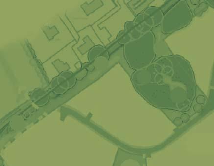
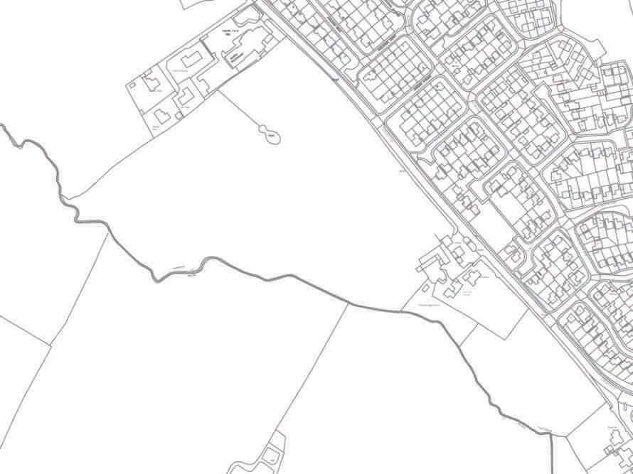
4 Reptile Mitigation Strategy 1.0 INTRODUCTION 1.1 This report provides details of potential mitigation and compensation works at land west of Padgbury Lane, Congleton, Cheshire in relation to reptiles. This report should be read in conjunction with the Reptile Survey Report (FPCR, July 2013) and Great Crested Newt Mitigation Strategy Padgbury Lane South (FPCR, February 2014). 1.2 An Environmental Impact Assessment has been prepared for a wider site, incorporating two separate outline planning applications, Padgbury Lane North and Padgbury Lane South. This report details the mitigation strategy for the individual site at Padgbury Lane South. 1.3 The site at Padgbury Lane South comprised unmanaged grassland suitable for use by reptiles. The main body of the site comprised unmanaged grassland with tussocks. The site is bound and bisected by hedgerows and Loach Brook flows northwards along the south-western boundary. Semi-improved and marshy grassland are present in association with the water-course and two ponds are present with the grassland habitat. 1.4 The composition of suitable reptile habitat throughout the site necessitated reptile surveys, which were undertaken using the standard methods recommended by the Herpetofauna Workers Manual 1 and the Froglife Advice Sheet 10 - Reptile Survey 2. Seven visits were made during 2013, with a peak count of 3 individual slow worm Anguis fragilis recorded. Froglife s method for assessing reptile population sizes is based on the peak number of adult reptiles seen using refugia/observed by one person in one day. Using these guidelines, the site supports a low population of slow worm (peak count of <5 adult slow worm). Slow worm were recorded within the northern extent of the site. 1.5 The site will also be subject to a great crested newt (GCN) mitigation strategy, as a population was recorded within the site. The reptile and great crested newt mitigation strategies will be integrated at the same time to ensure both reptiles and great crested newt are safely removed from the working area. 1.6 The site is situated to the west of Congleton, comprising 8.20 hectares. The surrounding landscape is predominantly agricultural land and residential development. The fields bordering Loach Brook to the south and west were in use as pasture and arable land at the time of survey. The land at Padgbury Lane North, immediately north, comprised further arable land bordered by hedgerows. Residential development is located to the east. 2.0 SURVEY METHODOLOGY Reptile Survey 2.1 A strategic reptile presence / absence survey was undertaken at specific locations identified as offering potential habitat within the area of survey. The survey was undertaken based on methodology detailed in the Herpetofauna Workers Manual (JNCC 1999) and the Froglife Advice Sheet 10 - Reptile Survey (Froglife 1999). Methods involved a search for basking reptiles on / 1 Herpetofauna Workers Manual, Gent and Gibson (1999). JNCC 2 Froglife (1999) An introduction to planning, conducting and interpreting surveys for snake and lizard conservation. Froglife Advice Sheet 10. Froglife, Halesworth J:\5200\5299\ECO\Reptiles 2
5 Reptile Mitigation Strategy under naturally occurring and strategically positioned artificial refugia. The artificial refugia used were 0.5m 2 sections of roofing felt with a black upper side. These were placed in locations that offered the most suitable habitat for common reptiles i.e. in open grassland, near hedgerows and along Loach Brook at a density of ten refugia per hectare of suitable habitat. The location of refugia is shown in Figure In addition, the surveys also followed the guidelines recommendations by: Approaching refugia from downwind and avoiding casting a shadow and with care so as to not disturb basking animals when checking; Lifting and replacing tins, to check for the presence of reptiles underneath in hot weather is undertaken with care, to avoid potential harm to any animals underneath; Assessment 2.3 Reptile populations were assessed in accordance with population level criteria as stated in the Key Reptile Site Register 3. This system classifies populations of individual reptile species into three population categories assessing the importance of the population (Table 1). These categories are based on the total number of animals observed during individual survey occasions. Table 1: Key Reptile Site Survey Assessment Categories (HGBI 1998) Species Low Population (No. of individuals) Good Population (No. of individuals) Exceptional Population (No. of individuals) Adder < >10 Common lizard < >20 Grass snake < >10 Slow worm < > LEGISLATION AND POLICY 3.1 All common reptile species, including common lizard and grass snake, are partially protected under Sections 9(1) and 9(5) of Schedule 5 of the Wildlife and Countryside Act 1981 (as amended) 4. This legislation protects these animals from: intentional killing and injury; selling, offering for sale, possessing or transporting for the purpose of sale or publishing advertisements to buy or sell a protected species. 3 Herpetofaune Groups of Britain and Ireland (1998), Evaluating Local Mitigation / Translocation Programmes: Maintaining Best Practice and Lawful Standard. HGBI advisory notes for Amphibian and Reptile Groups (ARGs). HGBI, c/o Froglife, Halesworth. Unpbubl 4 The Wildlife and Countryside Act 1981 (as amended). [Online]. London:HMSO Available from: [Accessed 11/11/2013] J:\5200\5299\ECO\Reptiles 3
6 Reptile Mitigation Strategy 3.2 The impact that this legislation has on the Planning system is outlined in ODPM 06/2005 Government Circular: Biodiversity and Geological Conservation Statutory Obligations and their Impact within the Planning System 5. This states: The presence of a protected species is a material consideration when a planning authority is considering a development proposal that, if carried out, would be likely to result in harm to the species or its habitat. Local authorities should consult English Nature [now Natural England] before granting planning permission. They should consider attaching appropriate planning conditions or entering into planning obligations under which the developer would take steps to secure the long-term protection of the species. They should also advise developers that they must comply with any statutory species protection provisions affecting the site concerned. 3.3 This partial protection does not directly protect the habitat of these reptile species. Where these animals are present on land that is to be affected by development, the implications of legislation are that providing that killing can reasonably be avoided then an operation is legal. Guidance provided by Natural England 6 and the Amphibian and Reptile Groups of the UK 7 recommends that this should be achieved by ensuring that: the animals are protected from injury or killing; mitigation is provided to maintain the conservation status of the species; population monitoring is carried out subsequent to operations. 3.4 All common reptiles are also included on the list of habitats and species which are of principal importance for the conservation of biodiversity in England as required under Section 41 of the Natural Environment and Rural Communities (NERC) Act 8. The S41 list is used to guide decision-makers, including local planning authorities, in implementing their duty under section 40 of the Act, to have regard to the conservation of biodiversity in England, when carrying out their normal functions. 4.0 RESULTS Desktop study 4.1 No local reptile records were provided for areas within 1km of the site boundary from consultees. Field survey 4.2 The surveys confirmed the presence of slow worm. No other reptile species were recorded during the surveys. Table 2: Reptile survey conditions and results 5 Government Circular: Biodiversity and Geological Conservation Statutory Obligations and their Impact within the Planning System (ODPM 06/2005, Defra 01/2005) 6 Reptiles: guidelines for developers, English Nature (2004). 7 Maintaining best practise in reptile mitigation/translocation programmes: Herpetofauna Groups of Britain and Ireland. 8 The Natural Environment and Rural Communities Act [Online]. Available from: [Accessed 14/11/2013] J:\5200\5299\ECO\Reptiles 4
7 Reptile Mitigation Strategy Survey Date and Time Weather Common lizard Grass snake Slow worm Other Species 1 18/06/2013 6pm 2 19/06/ am 3 24/06/2013 8am 4 27/06/2013 9am 5 01/07/2013 8am 19 o C Sunny Spells, 60% Cloud No rain, light Breeze 16 o C, 30% Cloud No rain 18 o C Partly Sunny No rain, slight Breeze 15 o C Partly Sunny No rain, slight Breeze 16 o C Sunny spells No rain, slight Breeze Toads /07/2013 7pm 7 09/07/2013 7am 16 o C Sunny No rain, slight Breeze 18 o C Sunny No rain, no wind Other Fauna 4.3 During the surveys the only additional species associated with refugia was common toad, with 6 individuals observed in a single survey visit. Population Size Class Assessment 4.4 The results indicate that the site supported a low population (<5 adults) of slow worm. Slow worm is a Cheshire region BAP priority species as it is an uncommon species within Cheshire (with only 4 records in the Cheshire region since 1995). Grass snake and slow worm are listed as species of principal importance under Section 41 of the NERC Act It is possible that the reptiles recorded during survey form part of a population that occupies suitable habitat in the wider landscape. However, slow worms do not move long distances with home ranges probably only several hundred square metres 9. It is therefore possible that slow worms are only present in the local area surrounding the area where this species was recorded. In order to ensure that no offence is committed and that the species is maintained at a favourable conservation status within the wider area a mitigation strategy comprising translocation and enhancement of retained habitats will be undertaken. 4.6 No grass snake were found but due to the relative difficulty in surveying grass snake, the presence of suitable habitat within the site and the transient nature of their foraging habitat it is considered likely that grass snake may be using the site in small numbers especially along the Loach Brook corridor. 9 Edgar, P. Foster, J. and Baker J. (2010), Reptile Habitat Management Handbook, Amphibian and Reptile Conservation, Bournemouth J:\5200\5299\ECO\Reptiles 5
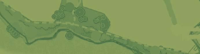
8 Reptile Mitigation Strategy 5.0 MITIGATION STRATEGY 5.1 Habitats suitable for reptile occupation are to be lost through proposals, comprising much of the grassland, scrub and woodland habitats. Retained habitats within the development include the permanent pond P2 and immediate surrounding habitats along with a wide margin along the connecting hedgerow and Loach Brook comprising rough grassland. 5.2 The following section provides details of mitigation required. Implementation of the following mitigation strategy is considered sufficient to ensure that the conservation status of the local reptile population is maintained. 5.3 Conservation status is defined as the sum of the influences acting on the species concerned that may affect the long term distribution and abundance of its population within its territory. It is assessed as favourable when: population dynamics data on the species concerned indicate that it is maintaining itself on a long term basis as a viable component of its natural habitats, and the natural range of the species is neither being reduced nor is likely to be reduced for the foreseeable future, and there is, or will probably continue to be, a sufficiently large habitat to maintain its populations on a long term basis. Assessment of Potential Impacts and Mitigation Strategies 5.4 Slow worm were only recorded in one location in the northern part of the site (Figure 1). This area is to be retained through proposals, however without the implementation of mitigation there is potential for an adverse impact on reptile species caused by: loss of habitat through vegetation clearance, Incidental harm during earthworks/site clearance. 5.5 Mitigation measures aim to ensure that reptiles are not killed or injured during works and that their local conservation status is maintained. 5.6 The precise method of translocation is greatly dependant on the nature of the construction programme and the phasing of development. Important factors include the extent of working area associated with each phase and the nature of habitat within it. 5.7 Due to the nature of the site and the presence of GCN, translocation methods would include trapping and translocation and hand removal of suitable vegetation and refugia. Receptor Areas 5.8 Trapping and translocation requires the active removal of individuals into suitable habitat elsewhere (a receptor site). The proposed receptor site will comprise retained and enhanced habitats within the northern and southern extents of the site. This area is also proposed to be used as a great crested newt reserve. The receptor area used will meet a number of criteria, as follows: An area that provides suitable habitat An area secure from development in the long-term J:\5200\5299\ECO\Reptiles 6
9 Reptile Mitigation Strategy An area that maintains connectivity with other areas of suitable habitat 5.9 Habitat enhancements will include the creation of hibernation features, such as log piles and artificial hibernacula The habitat enhancement in the receptor area will ensure that there is sufficient carrying capacity to support the translocated reptile population. Translocation Proposals Trapping and Translocation 5.11 Rough grassland habitat to be lost within the centre of the site provides suitable habitat for slow worm and grass snake. The scrub habitat at the south eastern extent of the site provides suboptimal habitat for reptiles, however is within 500m of the existing pond and therefore provides terrestrial habitat for GCN. Due to the extent of these habitats the whole area will be cleared by trapping and translocation. This area will be fenced with reptile/amphibian exclusion fencing to ensure that removed animals do not return to the affected area, with drift fencing installed where appropriate. Following this, refugia will be laid at a rate of 100 per hectare and pitfall traps will be installed every 5 m (50 pitfall traps per hectare each with 10m drift fencing) along fencing. Translocation will be undertaken only during the active period, between late- March to early-october when the daytime temperature is above 10 o C. Traps will be closed if evening temperatures drop below 5 o C. A total of 30 trapping visits will be made and once an average of fewer than two individuals per week of any reptile species has been reached and five clear GCN trapping days have been recorded at the end of the thirty days, a destructive search will be undertaken. Animals captured during the exercise will be recorded and translocated to the receptor areas. Trapping will only cease once five clear trapping days have been achieved Once caught, reptiles will be swiftly transferred into clean, cloth bags, taken to the receptor habitat and released immediately in order to minimise stress to individuals Once trapping has ceased, a destructive search will be undertaken and suitable scrub habitat removed by hand (detailed below). This will only be carried out during suitable weather conditions. The search will involve the supervised hand dismantling of features such as piles of brash and / or rubble, which may provide areas of refuge. Any individual found will be placed under newly created refugia within the receptor site The fencing will only be removed once development has ceased and/or the site has been made unsuitable for reptiles. Removal of Scrub 5.15 Removal of scrub will be undertaken in the south-eastern extent of the site. These habitats provide sub-optimal conditions due to the density of shading, homogenous structure and lack of refuge. Timings will take account of statutory constraints in relation to nesting birds with the initial cut (to 50cm) programmed outside of the breeding season (March to September inclusive) Trapping will take place during the bird breeding season and since all birds are protected whilst on the nest, all vegetation should be checked by an experienced ecologist prior to any removal. If active nests are found vegetation would be left untouched and suitably buffered until all birds have fledged. Removal of the scrub will involve a first cut using brushcutters with the vegetation cut to no less than 50 cm. This will take place prior to erection of fencing and prior to the J:\5200\5299\ECO\Reptiles 7
10 Reptile Mitigation Strategy breeding bird season. The retention of the lower section will ensure that any hibernating animals are left undisturbed The next cuts will only take place once great crested newt trapping has ceased and only between April and October during suitable weather conditions (temperatures above 10 C with no rain). The first cut would be to 200mm and the second 1-2 hours later to 50mm. All arisings will be removed from the working areas to prevent potential areas of refugia from being used by reptiles moving across the area. Any animals caught will be relocated into the receptor site All areas of existing suitable refuge within the working area such as rubble piles and other discarded items will be removed by hand under the supervision of a suitably experienced ecologist. Any animals caught will be relocated to the suitable retained habitat corridor along Loach Brook Following the final cut the roots will be removed under supervision of a suitably qualified ecologist. Any reptiles found should be removed to retained habitats Once removal is complete the working areas should be regularly strimmed during suitable weather to prevent formation of suitable habitat for use by reptiles In order to prevent any accidental encroachment of adjacent works into retained areas of suitable reptile habitat along Loach Brook, sturdy fencing such as Heras will be erected prior to the commencement of works. Fencing will be maintained throughout the construction phase. No material storage will be permitted within the fenced area The site manager and other relevant staff undertaking construction work will be briefed on the possible presence of grass snake and slow worm in the area. Staff will be provided with information relating to the legislation and briefed on the procedures to be implemented in the event that reptiles are found within the working area. The latter will include the capture and safe removal of any individuals present within the working area and their transfer to retained habitats. This will be undertaken by nominated site personnel, briefed in the procedure. Enhancement 5.23 The proposals include areas of retained and / or newly created habitat that will be managed to achieve conservation benefits for the existing reptile populations, along with other species. The management of the receptor areas and other areas of created habitats will be specifically designed to improve both the botanical and structural diversity of vegetation in order to benefit reptiles Enhancements for reptiles will improve the overall value and will include: The creation of several hibernacula and log piles to provide increased refuge availability; Creation of new water bodies which will provide an additional foraging resource for grass snake, should they be present Long term management to ensure the site continues to provide suitable habitat for reptiles Monitoring of the population for three years following completion of the development; recording of numbers and age-classes of reptiles associated with 20 tins located within the receptor site on three suitable occasions per year. J:\5200\5299\ECO\Reptiles 8
11


12

13 Padgbury Lane South, Congleton GRASSLAND ASSESSMENT March 2014
14 FPCR Environment and Design Ltd Registered Office: Lockington Hall, Lockington, Derby DE74 2RH Company No [T] [F] [E] [W] This report is the property of FPCR Environment and Design Ltd and is issued on the condition it is not reproduced, retained or disclosed to any unauthorised person, either wholly or in part without the written consent of FPCR Environment and Design Ltd. Ordnance Survey material is used with permission of The Controller of HMSO, Crown copyright Rev Issue Status Prepared / Date Approved/Date Draft HES / AL / A Final HES / AL / B Final HES / AL / C Final HES / AL /
15 CONTENTS 1.0 INTRODUCTION LEGISLATION RELATING TO LOCAL WILDLIFE SITES METHODOLOGY BASELINE SURVEY EVALUATION AND POTENTIAL EFFECTS PROPOSED MITIGATION...13 FIGURES Figure 1: Phase 1 Habitat Plan APPENDIX Appendix A: Extract from the Local Wildlife Site Selection Criteria for the Cheshire region (2012) J:\5200\5299\ECO\Eco App\Ecoapp\5299 Rev D.Doc 1
16 1.0 INTRODUCTION 1.1 This report details the results of a Phase 1 Habitat Survey undertaken by FPCR Environment and Design Ltd for land at Padgbury Lane, Congleton. Clarification of the extent and location of grassland habitats within the site has been sought and this report details these. This document provides an assessment of the potential of onsite semi-improved grassland to qualify for designation as a Local Wildlife Site (LWS) under the restorable grassland site selection criteria or as neutral grassland habitat of principal importance for the conservation of biodiversity (as listed within Section 41 of the Natural Environment and Rural Communities (NERC) Act (2006) (formerly referred to as UKBAP habitats) 1 ). This report should be read in conjunction with the Phase 1 Habitat Assessment (FPCR, 2013). 1.2 The site is situated to the west of Congleton, comprising 8.20 hectares. The surrounding landscape is predominantly agricultural land and residential development. The fields bordering Loach Brook to the south and west were in use as pasture and arable land at the time of survey. The land at Padgbury Lane North, immediately north, comprised arable land bordered by hedgerows. Residential development bounded the site to the east. 2.0 LEGISLATION RELATING TO LOCAL WILDLIFE SITES 2.1 Local Wildlife Sites are the most important non-statutory sites for nature conservation in Cheshire. Although not protected by national legislation they do receive policy protection (as Local Sites ), as reflected in the National Planning Policy Framework (NPPF). The NPPF suggests that Local Sites can have a fundamental role to play in meeting overall national biodiversity targets and that appropriate weight should be attached to designated sites when making planning decisions. 2.2 The NERC Act came into force on 1st October Section 41 (S41) of the Act requires the Secretary of State to publish a list of habitats and species that are of principal importance for the conservation of biodiversity in England. The list has been drawn up in consultation with Natural England, as required by the Act. 2.3 In addition the NPPF states planning policies should promote the preservation, restoration and re-creation of priority habitats, ecological networks and the protection and recovery of priority species populations, linked to national and local targets. Policies should also identify suitable indicators for monitoring biodiversity and aim to prevent harm to geological conservation interests. 3.0 METHODOLOGY 3.1 Fieldwork for the survey was originally conducted during May 2013, with subsequent visits made by the surveyor on a number of occasions during June, July and November. Survey of the grassland was undertaken in May, June and November 2013 using the standard Extended Phase 1 The Natural Environment and Rural Communities Act [Online]. Available from: [Accessed 20/11/2013] J:\5200\5299\ECO\Eco App\Ecoapp\5299 Rev D.Doc 2
17 1 Habitat Survey Methodology as recommended by Natural England 2, to identify specific habitats and features of ecological interest. Habitats were marked on a base plan and where appropriate, target notes were made. 3.2 Plant nomenclature follows Stace (2010) 3. Abundances are given as DAFOR ratings; D Dominant, A Abundant, F Frequent, O Occasional, R Rare, L Locally. Abundances relate to specific areas surveyed. Survey Analysis 3.3 The data gathered during the survey was applied to the following site selection guidelines as outlined in Local Wildlife Site Selection Criteria for the Cheshire Region 4. The following sections; are taken directly from this document. Indicator species are listed in Appendix A. Apart from semi-improved indicator species, all indicators can be used interchangeably. Please note, BAP priority habitat within the text has been superseded by NERC Act (2006) habitats of principal importance. Neutral grassland 3.4 Threshold to qualify as Lowland meadow BAP priority habitat (and LWS status) requires a minimum of: Four occasional indicator species (see Appendix A), at least three of which are listed as neutral grassland indicators. OR Four rare neutral grassland indicators (see Appendix A), Marshy grassland 3.5 Threshold to qualify as purple moor grass and rush pasture BAP priority habitat (and LWS status) requires a minimum of: Four occasional indicator species (see Appendix A), at least three of which are listed as marshy grassland indicators. OR Four rare marshy grassland indicators (see Appendix A), Acid grassland 3.6 Threshold to qualify as Lowland acid grassland BAP priority habitat (and LWS status) requires a minimum of: Three occasional acid grassland/heathland indicator species (see Appendix A), OR Four rare acid grassland/heathland indicators (see Appendix A). 2 JNCC. (1990). Handbook for Phase 1 habitat survey a technique for environmental audit. Peterborough: JNCC 3 Stace, C.A. (2010). New Flora of the British Isles. (3 rd Ed.). Cambridge: Cambridge University Press 4 November 2012, updated February Local Wildlife Site Selection Criteria for the Cheshire Region. J:\5200\5299\ECO\Eco App\Ecoapp\5299 Rev D.Doc 3
18 Calcareous grassland 3.7 Threshold to qualify as Lowland calcareous grassland BAP priority habitat (and LWS status) requires a minimum of: Four occasional indicator species (see Appendix A), at least three of which are listed as calcareous grassland indicators. OR Four rare calcareous grassland indicators (see Appendix A). Restorable grassland 3.8 Moderately species rich semi-improved, where there is good potential to restore to BAP quality. Threshold to qualify as restorable grassland habitat (and LWS status) requires a minimum of: Four occasional indicator species present from list (see Appendix A), but two or fewer occur from the lists given for neutral/acid/marshy/calcareous grassland. 3.9 Restorable semi-improved grassland should have less than 30% cover of white clover and rye grass and generally host at least three of the following grasses: common bent, crested dog s tail, false oat grass, meadow fescue, meadow foxtail, red fescue, sweet vernal grass, tufted hair grass (rarer grasses more typical of unimproved grassland may be counted). Undetermined species rich grassland 3.10 Threshold to qualify as BAP priority grassland habitat (and LWS status) requires a minimum of: Four occasional indicator species (see Appendix A), only one of which may be a semi-improved indicator. OR Any four rare neutral, marshy, acid or calcareous grassland indicators (see Appendix A) This type of grassland is still considered BAP priority habitat as indicator species are interchangeable. Species rich arable field margins may be selected using this criterion providing they are not sown. Sown wildflower grasslands may qualify under this criterion once they have proved to be sustainable e.g. retaining a species-rich sward approximately 20 years after sowing. Constraints A comprehensive species list was collected during the initial survey in May 2013 and subsequent surveys and further abundance data collected in accordance with the FEP handbook during November 2013 to determine the potential for the site to qualify as a Local Wildlife Site. November is outside the recommended survey season for grassland, however due to the number of visits made throughout the year, it is considered that the results are an accurate representation of what is present. Abundance data for grass species is not included. J:\5200\5299\ECO\Eco App\Ecoapp\5299 Rev D.Doc 4
19 4.0 BASELINE SURVEY Flora (Figure 2) 4.1 The grassland present appears to have been unmanaged for some years, the majority is species poor but diversity varies across the site. Target notes on the accompanying Phase 1 Habitat Plan (Figure 1) provide further detail on the composition of the locations of grassland across the site. Fence lines and hedgerows denote the main boundaries between grassland of differing management. Semi-improved Neutral Grassland 4.2 The main grassland compartment which extends from the fence line (denoted on the Phase 1 Habitat Plan as a dotted black line) to the northern boundary appears to have been left unmanaged for some time. This area comprises poor semi-improved neutral grassland (TN1) much of which is dominated by false oat-grass Arrhenatherum elatius. Other abundant and frequent grass species present included timothy Phleum pratense, common bent Agrostis capillaris and Yorkshire fog Holcus lanatus. The herb composition of this area was limited due to the lack of management and dominance of coarse grasses, with creeping buttercup Ranunculus repens and common sorrel Rumex acetosa found to be the only herb species of any abundance. Further herb species were rare throughout the sward and very localised, including greater bird sfoot-trefoil Lotus pedunculatus, selfheal Prunella vulgaris and ribwort plantain Plantago lanceolata. The initial survey in May identified pignut Conopodium majus although this was restricted to the peripheries. Ruderal herb species, such as creeping thistle Cirsium arvense and hogweed Heracleum sphondylium were interspersed throughout the open grassland and found to be abundant through the centre of this habitat. Ruderal herbs formed a considerable part of the grassland composition. 4.3 Two specimens of a marsh orchid (considered to be northern marsh orchid) Dactylorhiza purpurella were noted within the grassland north of the pond (TN2). Table 1: Species List: Compartment TN1 TAXON COMMON NAME ABUNDANCE (within the survey area) Agrostis capillaris* Common bent - Alopecurus pratensis* Meadow foxtail - Arrhenatherum elatius* False oat-grass - Cardamine pratensis* Cuckooflower r Cerastium fontanum Common mouse-ear r Cirsium arvense Creeping thistle a Cirsium vulgare Spear thistle o Conopodium majus Pignut r Dactylis glomerata Cocks-foot - Dryopteris dilatata Broad-buckler fern r Dropteris filix-mas Male fern r Festuca rubra agg* Red fescue - Galium aparine Common cleavers o J:\5200\5299\ECO\Eco App\Ecoapp\5299 Rev D.Doc 5
20 TAXON COMMON NAME ABUNDANCE (within the survey area) Heracleum sphondylium Hogweed f Juncus effusus Soft-rush r Lamium album White dead-nettle r Lotus pedunculatus Greater bird s-foot-trefoil r Plantago lanceolata* Ribwort plantain r Poa annua Annual meadow-grass - Poa trivialis Rough meadow-grass - Prunella vulgaris* Selfheal r Ranunculus repens Creeping buttercup o / lf Rumex acetosa* Common sorrel a Rumex obtusifolius Broad-leaved dock o Rumex conglomeratus Clustered dock r Senecio jacobaea Common ragwort f Silene dioica Red campion r Taraxacum officinale agg Dandelion r Trifolium repens White clover r Urtica dioica Common nettle f Species listed in bold are Cheshire LWS grassland indicator species Those underlined are also neutral grassland indicators Those with a star * are also restorable semi-improved grassland indicators 4.4 The grassland found to the south and west of the above (TN3 and TN4) was generally found to comprise a different structure to that found in TN1. Parts of the grassland appear to be rabbit grazed. The grassland displays a tussock structure. Only very small differences occur in species composition, detailed below. 4.5 The grassland found within TN3 differed in structure due to an abundance of common bent, red fescue Festuca rubra agg. and cock s-foot Dactylis glomerata with false oat-grass less frequent. Additional species included hairy sedge Carex hirta (locally frequent), sweet vernal-grass Anthoxanthum odoratum, crested dog s-tail Cynosurus cristatus and meadow buttercup Ranunculus acris (rare). 4.6 The area directly north of this (TN4) was similar in composition to TN3, this area supported slightly more diversity. One specimen of common spotted orchid Dactylorhiza fuchsii was identified within the north-western extent of the grassland in close proximity to existing residential development (TN5). 4.7 The centre of the grassland that occupied TN4 (TN6) was dominated by grass species such as Yorkshire fog, sweet vernal-grass and common bent. Rabbit grazing had maintained a short open sward in this area and forbs such as common sorrel and creeping buttercup were still abundant throughout the sward. Further species present were rare or occasional throughout and included ribwort plantain, common knapweed, greater bird s-foot-trefoil, meadow vetchling Lathyrus pratensis, field wood-rush Luzula campestris and common bird s-foot-trefoil Lotus corniculatus. Ruderal herbs were limited in this area. J:\5200\5299\ECO\Eco App\Ecoapp\5299 Rev D.Doc 6
21 Table 2: Species List: Compartment TN6 TAXON COMMON NAME ABUNDANCE (within the survey area) Agrostis capillaris* Common bent - Alopecurus pratensis* Meadow foxtail - Anthoxanthum odoratum* Sweet vernal grass - Arrhenatherum elatius* False oat-grass - Cadamine flexuosa Wavy bittercress r Carex hirta Hairy sedge f Centaurea nigra Common knapweed r Cerastium fontanum Common mouse-ear r Cirsium arvense Creeping thistle o Dactylis glomerata Cocks-foot - Dactylorhiza fuchsii Common spotted orchid r (peripheries) Festuca rubra agg.* Red fescue - Galium aparine Common cleavers r Holcus lanatus Yorkshire fog - Holcus mollis Creeping soft-grass - Juncus conglomeratus Compact rush r Lathyrus pratensis Meadow vetchling r Lotus corniculatus Bird s-foot trefoil r Lotus pedunculatus Greater bird s-foot trefoil r Luzula campestris* Field wood-rush r Phleum pratense Timothy - Plantago lanceolata* Ribwort plantain o Potentilla reptans Creeping cinquefoil r Prunella vulgaris* Selfheal r Ranunculus acris* Meadow buttercup r Ranunculus repens Creeping buttercup a Rumex acetosa* Common sorrel a Rumex conglomeratus Clustered dock r Rumex obtusifolius Broad-leaved dock o Senecio jacobaea Common ragwort la / o Stellaria media Common chickweed r Taraxacum officinale agg. Dandelion r Trifolium repens White clover r Urtica dioica Common nettle r Veronica chamaedrys* Germander speedwell - Species listed in bold are Cheshire LWS grassland indicator species 5 Those underlined are also neutral grassland indicators Those with a star * are also restorable semi-improved grassland indicators 5 Nov Local Wildlife Site Selection Criteria for the Cheshire region. Fourth Draft J:\5200\5299\ECO\Eco App\Ecoapp\5299 Rev D.Doc 7
22 4.8 The fields south of the fence line appeared to have been subject to a degree of grazing (TN7 and TN8) and supported more ruderal vegetation with patches of common nettle Urtica dioica, broadleaved dock and creeping thistle. The presence of perennial rye-grass Lolium perenne and abundant creeping buttercup and white clover suggests the fields had been subject to improvement. White clover was found to be abundant across both field compartments, with more than 30% coverage. A small area surrounding the ephemeral pond (TN9) within the southern extent of field TN8 was found to support localised species richness, detailed below. 4.9 Sheep s sorrel Rumex acetosella was only found within the most southern field (TN8), as a small localised patch. No other acid-loving plants were identified The southern extent of the grazed field (TN9) was low lying and a small localised patch supporting a greater diversity of species was present in association with the ephemeral pond. The species listed in the text below were limited to this localised area (TN9) and included field wood-rush Luzula campestris, soft rush Juncus effusus, hard rush Juncus inflexus, wavy bittercress Cardamine flexuosa, great willowherb Epilobium hirsutum, cuckooflower Cardamine pratensis, pignut Conopodium majus, bird s-foot-trefoil Lotus corniculatus and lesser stitchwort Stellaria graminea. The species list for the grassland compartments TN7 and TN8 is provided in Table 3 below. Table 3: Field compartments TN7 and TN8 TAXON COMMON NAME ABUNDANCE (within the survey area) Aegopodium podagraria Ground elder r Alopecurus geniculatus Marsh foxtail - Alopecurus pratensis* Meadow foxtail - Angelica sylvestris Wild angelica r Anthoxanthum odoratum* Sweet vernal-grass - Argentina anserina Common silverweed o Arrhenatherum elatius* False oat-grass - Bellis perennis Daisy r Cardamine pratensis* Cuckooflower r Cardamine flexuosa Wavy bittercress r Centaurea nigra Common knapweed r Cerastium fontanum Common mouse-ear o Chamerion angustifolium Rosebay willowherb lf Cirsium arvense Creeping thistle lf / r Cirsium vulgare Spear thistle r Conopodium majus Pignut r Dactylis glomerata Cocks-foot - Epilobium hirsutum Great willowherb la Festuca rubra agg* Red fescue - Galium aparine Common cleavers r Heracleum sphondylium Hogweed r Juncus conglomeratus Compact rush - J:\5200\5299\ECO\Eco App\Ecoapp\5299 Rev D.Doc 8
23 TAXON COMMON NAME ABUNDANCE (within the survey area) Juncus effusus Soft-rush la / r Juncus inflexus Hard rush r Lamium album White dead-nettle r Lotus corniculatus Bird s-foot-trefoil r Luzula campestris* Field wood-rush r Plantago lanceolata* Ribwort plantain lf / o Plantago major Greater plantain r Poa annua Annual meadow-grass - Poa trivialis Rough meadow-grass - Potentilla reptans Creeping cinquefoil lf Prunella vulgaris* Selfheal lf / r Ranunculus repens Creeping buttercup a Rumex acetosa* Common sorrel lf / o Rumex acetosella Sheep s sorrel r Rumex conglomeratus Clustered dock r Rumex obtusifolius Broad-leaved dock r Senecio jacobaea Common ragwort la / o Silene dioica Red campion r Stellaria graminea Lesser stitchwort r Stellaria media Common chickweed lf Taraxacum officinale agg Dandelion r Trifolium repens White clover a Urtica dioica Common nettle o Veronica chamaedrys* Germander speedwell r Veronica serpyllifolia Thyme-leaved speedwell r Species listed in bold are Cheshire LWS grassland indicator species Those underlined are also neutral grassland indicators Those with a star * are also restorable semi-improved grassland indicators 4.11 The banks adjacent to Loach brook (TN10) supported tussock grassland of similar composition to that of the grassland within TN4. A small pocket of more diverse grassland was present at TN11 with common knapweed Centaurea nigra, meadow vetchling Lathyrus pratensis and creeping cinquefoil Potentilla reptans recorded frequently. Further species recorded comprised betony Stachys officinalis, bush vetch Vicia sepium, hairy tare Vicia hirsuta, tufted vetch Vicia cracca and common bird s-foot-trefoil Lotus corniculatus. A species list for this area is provided in table 4 below. Table 4: Semi-improved Neutral Grassland along banks adjacent to Loach brook (TN10) TAXON COMMON NAME ABUNDANCE (within the survey area) Agrostis capillaris* Common bent - Alopecurus pratensis* Meadow foxtail - J:\5200\5299\ECO\Eco App\Ecoapp\5299 Rev D.Doc 9
24 TAXON COMMON NAME ABUNDANCE (within the survey area) Angelica sylvestris Wild angelica r Anthoxanthum odoratum* Sweet vernal grass - Arrhenatherum elatius* False oat-grass - Cadamine flexuosa Wavy bittercress Cardamine pratensis* Cuckooflower r Carex hirta Hairy sedge r Centaurea nigra Common knapweed lf / o Cerastium fontanum Common mouse-ear r Chamerion angustifolium Rosebay willowherb r Cirsium arvense Creeping thistle f Cirsium vulgare Spear thistle r Conopodium majus Pignut r (peripheries) Dactylis glomerata Cocks-foot - Deschampsia cespitosa* Tufted hair-grass - Digitalis purpurea Common foxglove r Festuca rubra agg.* Red fescue - Galium aparine Common cleavers r Heracleum sphondylium Common hogweed o Holcus lanatus Yorkshire fog - Holcus mollis Creeping soft-grass - Hypericum perforatum Perforate St. John s-wort r Juncus conglomeratus Compact rush - Juncus articulates / acutiflorus Jointed / sharp flowered rush - Juncus effusus Soft-rush - Juncus inflexus Hard rush - Lathyrus pratensis Meadow vetchling lf / o Lotus corniculatus Bird s-foot trefoil r Lotus pedunculatus Greater bird s-foot trefoil r Phleum pratense Timothy - Plantago lanceolata* Ribwort plantain la / o Potentilla reptans Creeping cinquefoil lf / r Prunella vulgaris* Selfheal r Ranunculus acris* Meadow buttercup r Ranunculus ficaria Lesser celandine - Ranunculus repens Creeping buttercup f Rubus fruticosus agg Bramble r Rumex acetosa* Common sorrel a Rumex conglomeratus Clustered dock r Rumex obtusifolius Broad-leaved dock o Scrophularia nodosa Common figwort r J:\5200\5299\ECO\Eco App\Ecoapp\5299 Rev D.Doc 10
25 TAXON COMMON NAME ABUNDANCE (within the survey area) Senecio jacobaea Common ragwort o Silene dioica Red campion r Solanum dulcamara Bittersweet r Stachys officinalis Common betony r Stellaria graminea Lesser stitchwort lf Stellaria holostea Greater stitchwort lf Stellaria media Common chickweed r Taraxacum officinale agg. Dandelion r Urtica dioica Common nettle o Veronica chamaedrys* Germander speedwell - Vicia cracca Tufted vetch r Vicia hirsuta Hairy tare r Vicia sepium Bush vetch r Species listed in bold are Cheshire LWS grassland indicator species 6 Those underlined are also neutral grassland indicators Those with a star * are also restorable semi-improved grassland indicators Marshy Grassland 4.12 The grassland gently slopes down towards the brook on the western periphery of the site and at its southern extent (the beginning of the slope indicated by the red dotted line on the Phase 1 Habitat Plan). The grassland adjacent to the brook supported areas of low-lying marshy grassland with small amounts of standing water. Species typical of wet conditions were observed and included great willowherb Equisetum hirsutum, greater bird s-foot-trefoil, marsh horsetail Equisetum palustre, marsh thistle Cirsium palustre, bog stitchwort Stellaria uliginosa, marsh bedstraw Galium palustre, amphibious bistort Persicaria amphibian and a rush species Juncus sp.. Marsh marigold Caltha palutris and a sweet-grass Glyceria sp. were identified within the north-western extent of the marshy grassland. These areas are within the floodplain and the presence of these species suggests they are at least ephemerally wet, if not wet most of the year round. Himalayan balsam Impatiens glandulifera, an invasive species listed on schedule 9 of the Wildlife and Countryside Act 1981, was identified in patches along the brook edge and within the wetter areas of the site. 5.0 EVALUATION AND POTENTIAL EFFECTS 5.1 Padgbury Lane South is proposed for residential (up to 180 dwellings), community facilities and associated infrastructure. Public open space and green infrastructure will be incorporated into proposals ensuring all features of conservation value are retained where possible and enhanced. The neutral grassland located adjacent to the brook and banks (TN10) is to be retained where feasible with at least two thirds of this area retained and enhanced through proposals, along with a wide strip along the northern hedgerow (H4, Phase 1 Habitat Plan, Padgbury Lane South) 6 Nov Local Wildlife Site Selection Criteria for the Cheshire region. Fourth Draft J:\5200\5299\ECO\Eco App\Ecoapp\5299 Rev D.Doc 11
26 connecting the permanent pond with the brook. The majority of grassland on higher ground (TN1, TN3, TN4 and TN6) along with TN7 and TN8 is to be lost. 5.2 Using methodology provided within the Farm Environment Plan (FEP) recommended by Natural England 7 the following conclusions can be drawn. The methodology describes how to assess abundance levels for species within a grassland: 5.3 The way to assess this is to walk around the habitat and stop at regular intervals or random points along the way. For most habitats, stopping ten times will be enough. At each stop a square metre of the vegetation is assessed and all species recorded. A species is rare if it occurs in one or two stops out of ten. It is occasional if it occurs in three or four stops out of ten. Frequent species occur in five or more stops out of ten. Assessment of TN1, TN3 and TN4: Main body of grassland located within the higher lying area of the site 5.4 The grassland within TN1, TN3 and TN4 is considered to be species poor due to the abundance of coarse grasses present. Thirteen indicator species have been identified throughout the sward, however many of these were found to be rare and are unlikely to be encountered in enough abundance to include them as indicators. 5.5 Under the semi-improved grassland criteria one indicator species was found in enough abundance to be considered within the criteria, this being common sorrel (abundant). The grassland also supports more than three grass species (Yorkshire fog, common bent, false oatgrass, red fescue, sweet vernal grass, crested dog s-tail and meadow foxtail) which are necessary species for qualification as restorable semi-improved grassland. 5.6 Under the neutral grassland criteria, only one species, ribwort plantain which is considered to be rare, is present. It is therefore considered that this grassland does not meet the selection criteria for designation as a restorable semi-improved grassland or neutral grassland Local Wildlife Site. Assessment of TN6: Small area within the main body of grassland 5.7 A small section (TN6: approximately 0.4ha in extent) of the rough grassland present within the main body of the site supported a slightly greater diversity and structure. Eleven grassland indicators were identified within this area, most of which were considered to be rare using the FEP methodology. 5.8 Indicator species of restorable semi-improved grassland comprised one occasional species; ribwort plantain and five rare species; field wood-rush, selfheal, meadow buttercup, common sorrel and germander speedwell. The grass species present were indicative of semi-improved grassland and comprised common bent, meadow foxtail, sweet vernal grass, false oat-grass and red fescue. This area is not considered to meet the criteria for selection as a restorable semiimproved grassland Local Wildlife Site. 5.9 Five neutral grassland indicator species have been identified within this area, one which was not recorded at any of the ten stops and could not be used in the assessment; common spotted orchid. The further indicator species were found to be rare; common knapweed and meadow 7 Natural England. March Higher Level Stewardship, Farm Environment Plan (FEP) Manual; Third Edition. (sections and 2.4.2) J:\5200\5299\ECO\Eco App\Ecoapp\5299 Rev D.Doc 12
27 vetchling, bird s-foot-trefoil and greater bird s-foot-trefoil. It is considered that this area only just meets the criteria for selection as a Neutral Grassland Local Wildlife Site. Assessment of TN7 and TN8: Grazed fields to the south of the site 5.10 The grassland within TN7 and TN8 was considered to be poor with a small pocket of localised species richness surrounding the ephemeral pond. Indicator species were generally confined to this area. Ten grassland indicator species were identified within these fields Under the semi-improved grassland criteria four species were recorded during the ten stops. Two were found to be occasional; ribwort plantain and common sorrel and two found to be rare; selfheal and germander speedwell. Grasses present comprised sweet vernal grass, false oatgrass, red fescue, meadow foxtail and red fescue, however perennial rye-grass, creeping buttercup and white clover were found in abundance throughout the area. White clover and perennial rye-grass are found in large patches across these grassland areas, and comprise more than 30% coverage Three neutral indicator species were found to be rare in accordance with the Natural England methodology comprising common knapweed, pignut and common bird s-foot-trefoil. Sheeps sorrel was only recorded in one area of TN8, and was not recorded during the ten stops. It is considered that these areas of grassland do not qualify as a Local Wildlife Site under the criteria for semi-improved grassland or neutral grassland. Assessment of TN10: Grassland adjacent to Loach brook and along banks 5.13 The grassland along the banks and adjacent to the brook supported a slightly greater diversity compared to the rest of the site. Twelve grassland indicators were identified within the area, most of which were considered to be rare or occasional using the FEP methodology Indicator species of semi-improved grassland comprised one occasional species; ribwort plantain and five rare species; cuckooflower, selfheal, meadow buttercup, common sorrel and germander speedwell. As with the grassland within TN1, TN3, TN4 and TN6, the grass species present were indicative of semi-improved grassland and comprised a similar composition along with tufted hair-grass Deschampsia cespitosa. This area is not considered to meet the criteria for selection as a semi-improved grassland Local Wildlife Site Six neutral grassland indicator species have been identified within this area, two which were not recorded at any of the ten stops and could not be used in the assessment; pignut and common betony. Two indicator species were found to be occasional; common knapweed and meadow vetchling and two found to be rare; bird s-foot-trefoil and greater bird s-foot-trefoil. It is therefore considered that this area meets the criteria for selection as a Neutral Grassland Local Wildlife Site. 6.0 PROPOSED MITIGATION 6.1 Two thirds of the grassland adjacent to Loach Brook and along the banks (TN10) is being retained. The loss of a third of this area will be mitigated for by restoration of the retained areas to species-rich neutral grassland through implementation of an appropriate management regime and creation of an additional area of species rich neutral grassland to the north of TN10. Losses cover an area of approximately 0.4ha. Mitigation will include retention and management of an J:\5200\5299\ECO\Eco App\Ecoapp\5299 Rev D.Doc 13
28 area of 0.85 ha and creation of a new area of species rich grassland of approximately 0.11ha. Long term management would involve traditional hay meadow management comprising hay cutting in late July with all arisings removed and scrub management. 6.2 The grassland occupying TN6 covers an area of approximately 0.4ha and it is unfeasible to retain this area. The loss of this area would be mitigated for through enhancement of retained grassland (approximately 0.64ha) around the existing pond and along the hedgerow connecting the pond to Loach Brook. At least 50% of the bramble will be cleared from this area and an appropriate cutting regime will be implemented including monitoring to ensure management is having the desired effect. Retention and enhancement of this area will provide mitigation for the loss of TN6 and will provide robust green corridors of greater diversity and value for local wildlife. 6.3 It can be seen from the above information that both areas that meet the LWS criteria only just meet them and both areas are in long-term decline due to lack of any management, which has resulted in dominance of coarse grasses and scrub invasion. The mitigation proposed for the loss of TN6 comprising approximately 0.4ha and the loss of a third of TN10 comprising approximately 0.4ha includes the retention and management of approximately 1.5ha of grassland enhancing the diversity of these areas and securing them in the long term and the creation of a further 0.1 ha of species rich neutral grassland directly linked to this area, which will also be subject to the same management regime. All management prescriptions would be agreed with Cheshire East s ecologist. Proposals ensure that there will be no significant effect from the loss of TN6 and partial loss of TN10. J:\5200\5299\ECO\Eco App\Ecoapp\5299 Rev D.Doc 14
29 Appendix A Extract from the Local Wildlife Site Selection Criteria for the Cheshire region (2012) Indicator species Refer to descriptions for H1- H12 for full explanation. In summary DAFOR occasional occurrence of any 4 species from list below denotes LWS status grassland. For acid grassland the threshold is 3 occasional acid grassland indicators. Indicators should not be confined to field edges Neutral grassland (lowland meadows and other neutral grassland). At least 4 DAFOR rare neutral indicators (or 3 occasional neutral indicators plus one other occasional indicator from the table). Habitat type (indicators are all interchangeable 1 ) Marshy Acid Lowland grasslan grassland Calcareou d (purple or acid s moor grass grassland/ grassland and rush heathland At least 4 pasture) At least 4 mosaics DAFOR rare calcareous DAFOR (dry and wet) indicators (or rare At least 4 3 occasional marshy DAFOR rare calcareous indicators or 3 indicators plus (or 3 occasional one other occasional acid occasional marshy indicators indicator from indicators should be the table). plus one present. other occasional indicator from the table). Semi-improved grassland a The presence of at least 4 DAFOR occasional indicators denotes grassland which may be restored to BAP quality. Indicators should not be confined to field edges Adder s tongue fern Agrimony Autumn hawkbit Betony Bilberry Biting stonecrop Bitter vetch Black knapweed Black medick Bloody crane's-bill Blue fleabane Bog asphodel Bog pimpernel Bristle club rush Buck's-horn plantain Bugle Bulbous buttercup Burnet saxifrage Carline thistle Clustered bellflower Common bird's-foot trefoil Common bistort Common catsear Common centaury Common meadow-rue Common rock-rose Common sorrel Common stork's-bill Common valerian Cotton grasses J:\5200\5299\ECO\Eco App\Ecoapp\5299 Rev D.Doc 15
30 Cowberry Cowslip Cranberry Crowberry Cuckoo flower Devilsbit scabious Dropwort (s) Dyer's greenweed Eyebrights Fairy flax Field scabious Field woodrush Gentians Germander speedwell Globeflower Goatsbeard Greater bird's-foot trefoil Greater burnet Greater knapweed Hairy violet Harebell Heath bedstraw Heath speedwell Heathers b Hemp-agrimony Hoary Plantain Hoary Rock-rose Horseshoe vetch Jointed rushes Kidney vetch Lady's bedstraw Lady's mantle sp. Lesser hawkbit Lesser spearwort Lesser trefoil Lesser water-parsnip Lichens Lousewort Marjoram Marsh cinquefoil Marsh hawk's-beard Marsh marigold Marsh pennywort Marsh valerian Marsh violet Marsh/fen bedstraw Meadow buttercup Meadow rue Meadow saxifrage Meadow thistle Meadow vetchling Meadowsweet Milkwort sp. Mountain pansy Mouse-ear hawkweed Narrow leaved water dropwort Orchids J:\5200\5299\ECO\Eco App\Ecoapp\5299 Rev D.Doc 16
31 Ox-eye daisy Parsley-pierts Pepper saxifrage Pignut Purple Milk-vetch Ragged robin Red clover Restharrow Ribwort plantain Rough hawkbit Salad burnet Saw-wort Selfheal Sheep's bit Sheep's-sorrel Shepherd's cress Small sedges c Small scabious Sneezewort Spagnum sp. Squinancywort Stemless/Dwarf thistle Sundew Thyme-leaved sandwort Thymes Tormentil (s) Violets Water avens Water mint Western gorse Whorled caraway Wild angelica Wild basil Wild strawberry Wild Thyme Wood anemone Wood sage Yarrow Yellow rattle Yellow-wort a Restorable semi-improved grassland should generally host at least 3 of the following grasses: common bent, crested dog s tail, false oat grass, meadow fescue, meadow foxtail, red fescue, sweet vernal grass, tufted hair grass (rarer grasses typical of unimproved grassland also count) and should have less than 30% cover of white clover and rye grass. b Including cross leaved heath Erica tetralix, bell heather Erica cinerea, ling Calluna vulgaris. c Excluding hairy sedge Carex hirta. Indicators should not be confined to field edges. Occasional on the DAFOR scale of relative abundance equates to a minimum cover of 11% or the occurrence of a species in at least 3 random samples from a total of ten assessments 8. Cheshire grassland axiophytes 9 not listed above and species listed under S13 can be considered as indicators. 8 Defra FEP Manual. Third edition BSBI axiophyte tables J:\5200\5299\ECO\Eco App\Ecoapp\5299 Rev D.Doc 17
32 THIS PAGE IS LEFT BLANK INTENTIONALLY J:\5200\5299\ECO\Eco App\Ecoapp\5299 Rev D.Doc 18
33
A revision of the Alopecurus pratensis - Sanguisorba officinalis (MG4) grassland community of the NVC 2014
 grassland community of the NVC 2014") A revision of the Alopecurus pratensis - Sanguisorba officinalis (MG4) grassland community of the NVC 2014 Mike Dodd Lowland floodplain meadows are recognised as a threatened habitat in the EU, being listed
A revision of the Alopecurus pratensis - Sanguisorba officinalis (MG4) grassland community of the NVC 2014 Mike Dodd Lowland floodplain meadows are recognised as a threatened habitat in the EU, being listed
St Mary s Churchyard, Potton
 2017 St Mary s Churchyard, Potton Laura Downton BCN Wildlife Trust September 2017 Grid Reference: SP 228 494 Date of visit: 8 th June 2017 Surveyor: Laura Downton from BCN Wildlife Trust 1. Site description
age 2 of 4 Bentley ond Grassland 19/08/2014 Survey Details Habitats ecorded National Vegetation Classifications MG7, Lolium perenne leys and related g
 age 1 of 4 Bentley ond Grassland 19/08/2014 Survey Summary Site Details Grid eference : SU78694409 ile eference : 74-0189 Total Area : 0.8 ha Civil arish : District : Vice-County : Survey Details Survey
Main Issues Report - Background Evidence 5. Site Analysis
 Main Issues Report - Background Evidence 5. Site Analysis 134 Cairngorms National Park Local Development Plan 135 Main Issues Report - Background Evidence 5. Site Analysis 136 Cairngorms National Park
Lamb Drove SUDS Showcase Project Cambourne Phase 1 Habitat Survey 2010
 Lamb Drove SUDS Showcase Project Cambourne Phase 1 Habitat Survey 2010 Cambridgeshire County Council May 2010 Final Report 9S7422 HASKONING UK LTD. ENVIRONMENT Rightwell House Bretton Peterborough PE3
Bromyard Downs. Phase 1 Habitat Survey Report
 Bromyard Downs Phase 1 Habitat Survey Report Prepared by Catherine Coton and Ben Wood September 2014 Contents Introduction Page 3 Methodology Page 4 Phase 1 Habitats and descriptions in each management
20 Common Urban Plants in Ireland
 20 Common Urban Plants in Ireland Leaflet produced by Phoebe O'Brien based on species seen during a Heritage Week walk in August 2017 Annual Meadow-grass (Poa annua) The small Annual Meadow-grass has white
FIELD IDENTIFICATION: RYTON MEADOWS NATURE RESERVE
 CERTIFICATE IN ECOLOGY AND WILDLIFE CONSERVATION FIELD IDENTIFICATION: RYTON MEADOWS NATURE RESERVE JAYE WHALLEY 30 July 2008 Page 1 INTRODUCTION The location is Ryton Meadows Nature Reserve (Grid Ref:
Appendix A.8.21 Lackagh Quarry Petrifying Spring Survey Results
 Appendix A.8.21 Lackagh Quarry Petrifying Spring Survey Results A.8.21 Lackagh Quarry Petrifying Spring Survey The results of the Petrifying spring survey at Lackagh Quarry are presented below in Table
An ecological basis for the management of grassland field margins
 Aspects of Applied Biology 108, 2011 Vegetation Management An ecological basis for the management of grassland field margins By S E SPRATT, A COOPER and T McCANN Environmental Sciences Research Institute,
Durham Coastal Grasslands Restoration Project
 Durham Coastal Grasslands Restoration Project Further monitoring to assess the feasibility and effectiveness of seed transfer 2014 Produced by Andy Mclay Contents Background 3 Introduction 3 Summary of
The brilliant wildflowers of County Durham s limestone
 Whilst you are out looking at the wonderful wildflowers, you could also make a note of what you see. You can help us to find out more about the wildlife of this area. We would like you to join us to record
It was small group of us who set out on a sunny but windy day, and just being in such a beautiful spot made us all feel good!
 U3A field trip to Anchor Bottom, May 13 th 2016. It was small group of us who set out on a sunny but windy day, and just being in such a beautiful spot made us all feel good! As we walked in we spotted
Provisional revision of the MG4 Alopecurus pratensis - Sanguisorba officinalis community Hilary Wallace and Mike Prosser
 Provisional revision of the MG4 Alopecurus pratensis - Sanguisorba officinalis community Hilary Wallace and Mike Prosser Ecological Surveys (Bangor) and Floodplain Meadows Partnership (Open University)
FOD+AG Project at the Bristol Botanic Garden Report
 FOD+AG Project at the Bristol Botanic Garden. 2014 Report One of the most interesting features of the Botanic Garden, for those to whom conservation is of vital importance, is the area devoted to the plants
Dunbeacon Shingle SAC (site code: )
") NPWS Dunbeacon Shingle SAC (site code: 002280) Conservation objectives supporting document- Coastal habitats Version 1 December 2017 Contents 1 Introduction... 2 2 Conservation Objectives... 2 3 Perennial
NPWS Dunbeacon Shingle SAC (site code: 002280) Conservation objectives supporting document- Coastal habitats Version 1 December 2017 Contents 1 Introduction... 2 2 Conservation Objectives... 2 3 Perennial
Roberts Wildflowers. A photographic guide to showy wildflowers of Roberts Regional Recreation Area. Sorted by Flower Color
 Roberts Wildflowers A photographic guide to showy wildflowers of Roberts Regional Recreation Area Sorted by Flower Color Photographs by Wilde Legard Botanist, East Bay Regional Park District Revision:
Ainsdale Hope School playing-field an ecological survey
 1 Ainsdale Hope School playing-field an ecological survey Philip H. Smith & Patricia A. Lockwood, June 2013 Introduction It is proposed to develop a community nature reserve on playing fields owned by
Flower-Insect Timed Count: target flower guide
 Flower-Insect Timed Count: target flower guide This guide has been developed to support the Flower-Insect Timed Count survey (FIT Count) that forms part of the Pollinator Monitoring Scheme (PoMS). Contents
Kencot Hill Solar Farm, near Kencot, Oxfordshire. Ecological Monitoring Report
 Kencot Hill Solar Farm, near Kencot, Oxfordshire Ecological Monitoring Report October 2016 Windrush Ecology Limited Howbery Park Benson Lane Wallingford OX10 8BA Tel 01491 822681 Web www.windrushecology.com
Flamborough and Scarborough Coast. Project ID: LB12/ Maritime Cliff and Slope Vegetation Survey
 Flamborough and Scarborough Coast Project ID: LB12/13-182 Detailed SSSI Notification Review Submitted to: Natural England 4th Floor Foss House Kings Pool 1-2 Peasholme Green York YO1 7PX November 2012
PURPOSE... i. Abbreviations... i. 1 Introduction Methods Compliance with Management Plans Results Discussion...
 PURPOSE... i Abbreviations... i 1 Introduction... 1 2 Methods... 3 3 Compliance with Management Plans... 5 4 Results... 6 5 Discussion... 8 6 Next Steps... 9 Appendix A... 1 Table 1 Flora monitoring
The brilliant wildflowers of the Limestone Coast
 Whilst you are out looking at the wonderful wildflowers, you could also make a note of what you see. You can help us to find out more about the wildlife of this area. We would like you to join us to record
Tiree s great yellow bumblebee project
 Tiree s great yellow bumblebee project * * * * * Facts about the great yellow bumblebee LATIN NAME Bombus distinguendus GAELIC NAME Seillean mòr buidhe HOW RARE ARE THEY? It s one of the UK s rarest bumblebees
Lugg Meadows Vegetation Study
 Natural England Commissioned Report NECR071 Lugg Meadows Vegetation Study First published 25 October 2011 www.naturalengland.org.uk Foreword Natural England commission a range of reports from external
working today for nature tomorrow
 Report Number 697 Review of the diet and micro-habitat values for wildlifeand the agronomic potential of selected grassland plant species English Nature Research Reports working today for nature tomorrow
CHALK GRASSLAND RESTORATION AT COOMBE END FARM, GORING HEATH
 CHALK GRASSLAND RESTORATION AT COOMBE END FARM, GORING HEATH Dr Chris Smith, Farm & Countryside Liaison Services, Bridgwater, Somerset Background During the preparation of a Whole Farm Plan for National
Appendix A.8.19 Habitat Survey Results - Species Lists
 Appendix A.8.19 Habitat Survey Results - Lists EIAR_Appendix A.8.19 A.8.19 This appendix presents the species lists for habitats recorded along, and adjacent to, the proposed road development. Section
Favourable Condition of Blanket Bog on Peak District SSSIs. Richard Pollitt Lead Adviser, Conservation & Land Management, Dark and South West Peak
 Favourable Condition of Blanket Bog on Peak District SSSIs Richard Pollitt Lead Adviser, Conservation & Land Management, Dark and South West Peak Definitions SSSI Site of Special Scientific Interest statutory
How-to-guide. Collecting and using pollinator friendly wildflower seed All-Ireland
 Online edition: ISSN 2009-6852 Print edition: ISSN 2009-6844 National Biodiversity Data Series No. 6. How-to-guide Collecting and using pollinator friendly wildflower seed All-Ireland Pollinator Plan 2015-2020
Between-observer variation in the application of a standard method of habitat mapping by environmental consultants in the UK
 Journal of Applied Ecology 1999, 36, Between-observer variation in the application of a standard method of habitat mapping by environmental consultants in the UK ANDREW CHERRILL and COLIN MCCLEAN* Ecology
Dune habitat conservation status assessment review
 Annotated document key - Item Summary Emphasis Dune habitat conservation status assessment review CCW carried out an assessment of the condition of the dune habitats of the SAC in the summer of 2005 and
Appendix A.8.4 Galway City Transport Project Assessment of Annex I habitats in the Ballygarraun survey area (Perrin, 2014)
") Appendix A.8.4 Galway City Transport Project Assessment of Annex I habitats in the Ballygarraun survey area (Perrin, 2014) A.8.4 N6 Galway City Transport Project Assessment of Annex I habitats in the Ballygarraun
Appendix A.8.4 Galway City Transport Project Assessment of Annex I habitats in the Ballygarraun survey area (Perrin, 2014) A.8.4 N6 Galway City Transport Project Assessment of Annex I habitats in the Ballygarraun
Varying diversity patterns of vascular plants, bryophytes, and lichens at different spatial scales in central European landscapes
 Varying diversity patterns of vascular plants, bryophytes, and lichens at different spatial scales in central European landscapes Jürgen DENGLER, University of Hamburg & Marc-André ALLERS, ETH Zurich Contents
Identifying faithful neighbours of rare plants in Britain; an application of the TPP dataset
 Identifying faithful neighbours of rare plants in Britain; an application of the TPP dataset Simon Smart (ssma@ceh.ac.uk), Kevin Walker, Peter Henrys, Oli Pescott, Rob Marrs Centre for Ecology & Hydrology,
FARWAY CASTLE, EAST DEVON: POLLEN ASSESSMENT REPORT
 Quaternary Scientific (QUEST) Unpublished Report April 0; Project Number 07/ FARWAY CASTLE, EAST DEVON: POLLEN ASSESSMENT REPORT C.R. Batchelor Quaternary Scientific (QUEST), School of Human and Environmental
ECOFACT Volume 1. The main objectives of the work which produced the present book were therefore:
 ECOFACT Volume 1 Introduction and Approach: Introduction The vegetation and land cover of the British countryside were surveyed in 199 by the Institute of Terrestrial Ecology under a contract from the
Spaunton Quarry, Appleton Le Moors Ryenats Trial Study 2014
 Spaunton Quarry, Appleton Le Moors Ryenats Trial Study 2014 Photos of flowers and insects below Spaunton Quarry is a disused limestone quarry west of Appleton Le Moors, SE7187-SE7286. It measures approximately
VEGETATION ATTRIBUTES OF FOUR INTEGRATED PEST MANAGEMENT (IPM) SITES ON THE VICTORIAN VOLCANIC PLAIN
 SITES ON THE VICTORIAN VOLCANIC PLAIN") VEGETATION ATTRIBUTES OF FOUR INTEGRATED PEST MANAGEMENT (IPM) SITES ON THE VICTORIAN VOLCANIC PLAIN Report prepared for Cam Nicholson, Southern Farming Systems, Newtown Victoria 322 February 27 Vivienne
VEGETATION ATTRIBUTES OF FOUR INTEGRATED PEST MANAGEMENT (IPM) SITES ON THE VICTORIAN VOLCANIC PLAIN Report prepared for Cam Nicholson, Southern Farming Systems, Newtown Victoria 322 February 27 Vivienne
FUNCTIONAL DIVERSITY AND MOWING REGIME OF FLOWER STRIPS AS TOOLS TO SUPPORT POLLINATORS AND TO SUPPRESS WEEDS
 FUNCTIONAL DIVERSITY AND MOWING REGIME OF FLOWER STRIPS AS TOOLS TO SUPPORT POLLINATORS AND TO SUPPRESS WEEDS Roel Uyttenbroeck 04 September 2017 Promotor: Arnaud Monty Co-promotor: Frédéric Francis Public
Flood Map. National Dataset User Guide
 Flood Map National Dataset User Guide Version 1.1.5 20 th April 2006 Copyright Environment Agency 1 Contents 1.0 Record of amendment... 3 2.0 Introduction... 4 2.1 Description of the Flood Map datasets...4
SIF_7.1_v2. Indicator. Measurement. What should the measurement tell us?
 Indicator 7 Area of natural and semi-natural habitat Measurement 7.1 Area of natural and semi-natural habitat What should the measurement tell us? Natural habitats are considered the land and water areas
Comparing losses and gains in biodiversity: Lessons learnt from HS2 Phase One
 Comparing losses and gains in biodiversity: Lessons learnt from HS2 Phase One John Simmons (URS) & David Collins (HS2 Ltd) IEEM Spring Conference, Birmingham 18 th March 2014 Environmental Overview Consultants
Do Native Plant Mixtures Reduce Invasions Along Roadsides in Wisconsin? Joslyn Mink MS Candidate University of Wisconsin-Madison
 Do Native Plant Mixtures Reduce Invasions Along Roadsides in Wisconsin? Joslyn Mink MS Candidate University of Wisconsin-Madison Wisconsin Department of Transportation (DOT) Invasive plants perceived to
Quite often plants are seen as the background against which the more interesting (animal) wildlife occurs. After all, often, when we use the word
 wildlife occurs. After all, often, when we use the word") 1 Quite often plants are seen as the background against which the more interesting (animal) wildlife occurs. After all, often, when we use the word 'habitat', we are actually using it as shorthand for
1 Quite often plants are seen as the background against which the more interesting (animal) wildlife occurs. After all, often, when we use the word 'habitat', we are actually using it as shorthand for
County Wildlife Action Plant List
 County Wildlife Action Plant List Site Name: East Hills (CWS 242) Date/s site visits: 16 th March 2017, 12 th May 2017, 20 th May 2017, 11 th June 2017, 24 th June 2017, 18 th July 2017, 23 rd July 2017,
7.34 Spartina (Spartina anglica)
") 7.34 Spartina (Spartina anglica) Why is it a threat? Spartina is a sward forming grass that originates from the United Kingdom. It grows from underground rhizomes. The rhizomes break off and establish
7.34 Spartina (Spartina anglica) Why is it a threat? Spartina is a sward forming grass that originates from the United Kingdom. It grows from underground rhizomes. The rhizomes break off and establish
RHOSYDD LLANPUMSAINT SITE OF SPECIAL SCIENTIFIC INTEREST
 RHOSYDD LLANPUMSAINT SITE OF SPECIAL SCIENTIFIC INTEREST Sam Bosanquet 2008 YOUR SPECIAL SITE AND ITS FUTURE Your Special Site and its Future is part of our commitment to improve the way we work with Site
Conserving Brownfield Biodiversity. Jamie Roberts Biodiversity Projects Manager
 Conserving Brownfield Biodiversity Jamie Roberts Biodiversity Projects Manager Brownfield: A hotbed of biodiversity 15% of all Red Data Book invertebrates occur on brownfields as important a resource as
Barcode UK: saving plants and pollinators using DNA barcoding
 Barcode UK: saving plants and pollinators using DNA barcoding Natasha de Vere National Botanic Garden of Wales Gwyddoniaeth yng Ngardd Cymru Science @ the Garden of Wales Cefnogi planhigion, peillwyr a
Laois Habitats Survey 2008
 Laois Habitats Survey 2008 Wet grassland with conifer plantation in the background in Gortahile Report prepared for Laois Heritage Forum: PART 2: Appendices An Action of the Laois Heritage Plan 2007-2011
DORMOUSE MONITORING IN FREEHOLDERS WOOD 2015
 DORMOUSE MONITORING IN FREEHOLDERS WOOD 2015 Photo: Ian Court YDNPA Ian Court, Wildlife Conservation Officer, Yorkshire Dales National Park Authority Ian White, People s Trust for Endangered Species March
The Governance of Land Use
 The planning system The Governance of Land Use United Kingdom Levels of government and their responsibilities The United Kingdom is a unitary state with three devolved governments in Northern Ireland,
Evaluating Wildlife Habitats
 Lesson C5 4 Evaluating Wildlife Habitats Unit C. Animal Wildlife Management Problem Area 5. Game Animals Management Lesson 4. Evaluating Wildlife Habitats New Mexico Content Standard: Pathway Strand: Natural
Study 11.9 Invasive Plant Study
 Initial Study Report Update Meeting Study 11.9 Invasive Plant Study March 29, 2016 Prepared by ABR, Inc. Environmental Research & Services 10/21/2014 1 Study 11.9 Status ISR documents (ISR Part D Overview):
Contents. 1. Introduction 3 2. Saltmarsh in Halton 4 3. Survey 5 4. Results 6 5. Conclusion 11
 Contents 1. Introduction 3 2. Saltmarsh in Halton 4 3. Survey 5 4. Results 6 5. Conclusion 11 2 1. Introduction A saltmarsh occurs between the mean high water level of neap tides and the mean high water
Rose, F. (1989) Grasses, sedges, rushes and ferns of the British Isles and north-western Europe. Viking
 Grasses, sedges, rushes and ferns of the British Isles and north-western Europe. Viking") The diversity of grasslands is often based on the presence of flowering plants and grasses. National Vegetation Classification (NVC) is a survey method that helps to identify the community of plants in
The diversity of grasslands is often based on the presence of flowering plants and grasses. National Vegetation Classification (NVC) is a survey method that helps to identify the community of plants in
GETTING BRITAIN MOVING THIS WINTER Forecast, Gritting and Snow Clearing Services from Paxman Landscapes UK Ltd
 GETTING BRITAIN MOVING THIS WINTER Forecast, Gritting and Snow Clearing Services from Paxman Landscapes UK Ltd Members of the Association of Professional Landscapers and the British Association of Landscape
2,4-D Amine 625. Herbicide PRODUCT SPECIFIC SPRAY DRIFT GUIDELINES APVMA PERMIT 87174
 2,4-D Amine 625 Herbicide PRODUCT SPECIFIC SPRAY DRIFT GUIDELINES AUTHORISING POSSESSION AND CUSTODY, SUPPLY AND USE, OF CERTAIN AGRICULTURAL CHEMICAL PRODUCTS CONTAINING THE ACTIVE CONSTITUENT 2,4-DICHLOROPHENOXYACETIC
Coastal Environment. Introduction. 4.1 Coastal Environment. Extent of Coastal Environment
 4 The primary objective (set out in Chapter 2) to be implemented by this Chapter is Objective 2.4 ; the following objectives are also relevant due to the objectives integrated nature: 2.1 Tāngata whenua
Conserving the diversity of forage genetic resources in managed grassland in Switzerland results and implementation
 Federal Department of Economic Affairs, Education and Research EAER Agroscope Conserving the diversity of forage genetic resources in managed grassland in Switzerland results and implementation Beat Boller,
Karr J.R. and D.R. Dudley Ecological perspective on water quality goals. Environmental Manager 5:55-68.
 Ecological Integrity Assessment: An Approach for Assessing Ecosystem Condition to Guide Conservation and Management Ecological Integrity " the ability of an ecosystem to support and maintain i a balanced
The micropalaeontology and palynology of a putative lacustrine clay deposit at Spittalmyre Farm, Montrose [1:50k sheet 57 (E) Montrose]
![The micropalaeontology and palynology of a putative lacustrine clay deposit at Spittalmyre Farm, Montrose [1:50k sheet 57 (E) Montrose]](/thumbs/90/102420500.jpg "The micropalaeontology and palynology of a putative lacustrine clay deposit at Spittalmyre Farm, Montrose [1:50k sheet 57 (E) Montrose]") The micropalaeontology and palynology of a putative lacustrine clay deposit at Spittalmyre Farm, Montrose [1:50k sheet 57 (E) Montrose] Geology and Landscape Northern Britain Programme Internal Report
The micropalaeontology and palynology of a putative lacustrine clay deposit at Spittalmyre Farm, Montrose [1:50k sheet 57 (E) Montrose] Geology and Landscape Northern Britain Programme Internal Report
Quantifying the unquantifiable: How to measure the success of habitat creation or restoration?
 Quantifying the unquantifiable: How to measure the success of habitat creation or restoration? Dr Alistair Headley PlantEcol Mobile: 07884 490494 Email: headleyplantecol@btinternet.com Phase 1 habitat
NOSE HILL PARK LINEAR BIRD TRANSECTS 2006
 NOSE HILL PARK LINEAR BIRD TRANSECTS 2006 Prepared by: Sweetgrass Consultants Ltd. Calgary, AB For: CITY OF CALGARY PARKS January 2007 Sweetgrass Consultants Ltd. 15112 Deer Run Dr. S.E. Calgary, AB T2J
Creating ponds for Marsh Clubmoss Lycopodielle inundata
 Creating ponds for Marsh Clubmoss Lycopodielle inundata Freshwater Habitats Trust 1. What is Marsh Clubmoss? Marsh Clubmoss Lycopodiella inundata is not a true moss but a primitive non-flowering plant
Ecological networks and coherence according to article 10 of the Habitats Directive
 Ecological networks and coherence according to article 10 of the Habitats Directive Introduction Within the scientific community ecological coherence next to habitat quality has long been acknowledged
PTEROPSIDA - Ferns. PINOPSIDA - Conifers. POLYPODIACEAE - Polypody family. Polypodium vulgare agg. DENNSTAEDTIACEAE - Bracken family
 VEGETATION COMMUNITIES OF HERBERT PLANTATION IN TAXONOMIC ORDER An * indicates it is an Ancient Woodland Vascular Plant but only where these species occur well within the wood, and do not appear to have
The Soils and Land Capability for Agriculture. Land North of Aberdeen, Aberdeenshire
 The Soils and Land Capability for Agriculture Of Land North of Aberdeen, Aberdeenshire Report prepared for Peter Radmall Associates May 2012 Reading Agricultural Consultants Ltd Beechwood Court, Long Toll,
Shadow Cliffs Wildflowers
 Shadow Cliffs Wildflowers A photographic guide to showy wildflowers of Shadow Cliffs Regional Recreation Area Sorted by Flower Color Photographs by Wilde Legard Botanist, East Bay Regional Park District
NATTERJACK TOAD Bufo calamita
 NATTERJACK TOAD Bufo calamita Hampshire Biodiversity Partnership Natterjack Toad 1 INTRODUCTION The Natterjack toad Bufo calamita is listed in the UK Biodiversity Steering Group report as a priority species
Assessment of samples for plant remains from Silbury Hill
 Assessment of samples for plant remains from Silbury Hill Samples for assessment of macroscopic plant remains from deposits likely or known to contain biological remains preserved as a result of anoxic
J A Webb Report. G.Dawe Report Surveys. Additional In 2014 COMMENTS. C T Hayes. Dec Oct CT Hayes
 RALEIGH PARK - PLANTS Updated 20 th June 2014 Red indicates additional plants found since the survey by Judy Webb. Blue indicates additional plants found in 2014. Not found since G Dawe Report () Not found
RESTORING ACTIVE BLANKET BOG IN IRELAND Project reference: LIFE02NAT/IRL/8490
 Page 1 of 34 RESTORING ACTIVE BLANKET BOG IN IRELAND Project reference: LIFE02NAT/IRL/8490 A REPORT ON THE RESTORATION OF PROJECT SITE No. 13. CROAGHONAGH, CO. DONEGAL. Compiled by: John Conaghan 11 Dun
Energy Use in Homes. A series of reports on domestic energy use in England. Energy Efficiency
 Energy Use in Homes A series of reports on domestic energy use in England Energy Efficiency Energy Use in Homes A series of reports on domestic energy use in England This is one of a series of three reports
BIOS 230 Landscape Ecology. Lecture #32
 BIOS 230 Landscape Ecology Lecture #32 What is a Landscape? One definition: A large area, based on intuitive human scales and traditional geographical studies 10s of hectares to 100s of kilometers 2 (1
Exploration targets identified to increase Browns Range Project s mine life
 Exploration targets identified to increase Browns Range Project s mine life Highlights Exploration Target estimate demonstrates the potential for very significant increases in Total Mineral Resource at
FLOWERS GROWING WILD IN BROADWAY
 FLOWERS GROWING WILD IN BROADWAY FLOWERS SEEN during AUGUST 2017 Month Common Name Botanical name Photograph 1 Photograph 2 Anemone: Japanese Anemone x hybrida Agrimony Agrimonia eupatoria Avens: wood
For personal use only
 ASX:LEG 10 July 2014 Fraser Range Aeromagnetic Survey Identifies Targets Seven priority targets considered prospective for nickel-copper Targets interpreted to relate to intrusive mafic/ultramafic bodies
Restoring Meanders to Straightened Rivers 1.7 Reconnecting remnant meanders
 .7 Reconnecting remnant meanders River Little Ouse Location - Thetford, Norfolk TL87082 Date of construction - 994 Length 900m Cost 5,000 Maximum extent of flooding during winter floods BTO boundary Small
Beekeeping in Urban Areas. Where to put your bees!
 Beekeeping in Urban Areas Where to put your bees! Check the laws in your area Go online Regulations such as distance from property lines Neighbors signatures Considerations Neighbors Pools Fences Dogs
Analysis of vegetation data from different quadrat sizes
 Natural England Commissioned Report NECR006 Analysis of vegetation data from different quadrat sizes First published 26 June 2009 www.naturalengland.org.uk Introduction Natural England commission a range
IUCN Red List Process. Cormack Gates Keith Aune
 IUCN Red List Process Cormack Gates Keith Aune The IUCN Red List Categories and Criteria have several specific aims to provide a system that can be applied consistently by different people; to improve
National Vegetation Classification Survey of Woodland at Kew. July 2008
 National Vegetation Classification Survey of Woodland at Kew July 2008 Giles Groome PhD MIEEM CEnv Consultant Ecologist 13 Park Road, Farnham, Surrey, GU9 9QN. giles.groome@btopenworld.com CONTENTS CONTENTS
Natural Resource Management. Northern Tasmania. Strategy. Appendix 2
 Natural Resource Management Strategy Northern Tasmania 2015 2020 Appendix 2 Appendix 2 Appendix 2. Carbon Planting Spatial Prioritisation In support of this Strategy s development and implementation, work
Issue 3 ENVIRONMENT MINISTER ASKS WHAT IS HAPPENING TO OUR COUNTRYSIDE? CONTENTS IS IT REALLY CLEVER? MEASURING VEGETATION CHANGE
 JUNE 99 Issue 3 NEWSLETTER FOR THE COUNTRYSIDE SURVEY 2000 ENVIRONMENT MINISTER ASKS WHAT IS HAPPENING TO OUR COUNTRYSIDE? Following publication of the results of the 1990 Countryside Survey a series of
In-channel coarse sediment trap Best Management Practice
 In-channel coarse sediment trap Best Management Practice By Henry R. Hudson July 2002 Environmental Management Associates Ltd., Christchurch Complexity Environmental Value Cost Low Moderate High Low Moderate
Brief for Habitat and Boundary survey and action plans
 Brief for Habitat and Boundary survey and action plans Introduction The Forest of Bowland Area of Outstanding Natural Beauty (AONB) is the lead partner of the proposed Pendle Hill Landscape Partnership
National Parks and Wildlife Service
 ISSN 2009-4086 National Parks and Wildlife Service Conservation Objectives Series Kilpatrick Sandhills SAC 001742 Page 1 of 13 National Parks and Wildlife Service, Department of Arts, Heritage, Regional,
Mitigating the human-elephant conflict in Sri Lanka: lessons from Southern Africa
 Mitigating the human-elephant conflict in Sri Lanka: lessons from Southern Africa Sanjay Kalpage 7 th International Wildlife Ranching Symposium Kimberly, South Africa, 11 th October, 2011 1 Overview Sri
Assessment and management of at risk populations using a novel GIS based UK population database tool
 Safety and Security Engineering 203 Assessment and management of at risk populations using a novel GIS based UK population database tool H. Balmforth 1, H. McManus 1 & A. Fowler 2 1 Health and Safety Laboratory,
2,4-D LV Ester 680. Herbicide PRODUCT SPECIFIC SPRAY DRIFT GUIDELINES APVMA PERMIT Adama PART 1 - PRELIMINARIES
 Adama 2,4-D LV Ester 680 Herbicide PRODUCT SPECIFIC SPRAY DRIFT GUIDELINES AUTHORISING POSSESSION AND CUSTODY, SUPPLY AND USE, OF CERTAIN AGRICULTURAL CHEMICAL PRODUCTS CONTAINING THE ACTIVE CONSTITUENT
ARCH PROJET Activity 1 -Synthesis-
 ARCH PROJET Activity 1 -Synthesis- CONTENT 1 ARCH project context... 3 1.1. General context... 3 1.2. The ARCH Project... 3 1.3. The Project ARCH partners... 3 1.4. The ARCH project content... 4 2 Activity
Effect of competition on the distribution of Marram Grass within a sand dune system Introduction
 » sjhoward.co.uk Effect of competition on the distribution of Marram Grass within a sand dune system Introduction Sand dunes provide a classic example of the progression of ecological succession, with
Access. Very limited at the quarry. Large car parks at the coast.
 Marsden Old Hall Quarry Local Nature Reserve. Vascular Plant Species Checklist 2012 Compiled and published by John Durkin, BSBI er for County Durham Habitats Area Key species Access Facilities More information
Devrinol (once soil settles after transplanting); Poast OR Venture (as needed). Authority. Ignite OR Aim for primocane control (Late. Spring.
; Poast OR Venture (as needed). Authority. Ignite OR Aim for primocane control (Late. Spring.") Raspberry Herbicide Options Kristen Obeid, OMAFRA Weed Management Specialist Horticulture The cooler weather this spring has slowed growth in perennial crops like raspberries. Before new raspberry shoots
Raspberry Herbicide Options Kristen Obeid, OMAFRA Weed Management Specialist Horticulture The cooler weather this spring has slowed growth in perennial crops like raspberries. Before new raspberry shoots
Map Name(s) and Date(s) Historical Map - Slice A
 and Date(s) Historical Map - Slice A") VectorMap Local Published 2016 Source map scale - 1:10,000 VectorMap Local (Raster) is Ordnance Survey's highest detailed 'backdrop' mapping product. These maps are produced from OS's VectorMap Local,
VectorMap Local Published 2016 Source map scale - 1:10,000 VectorMap Local (Raster) is Ordnance Survey's highest detailed 'backdrop' mapping product. These maps are produced from OS's VectorMap Local,
Date: June 19, 2013 Meeting Date: July 5, Consideration of the City of Vancouver s Regional Context Statement
 Section E 1.5 To: From: Regional Planning and Agriculture Committee Lee-Ann Garnett, Senior Regional Planner Planning, Policy and Environment Department Date: June 19, 2013 Meeting Date: July 5, 2013 Subject:
Butterfly Report
 Butterfly Report 2012-2014 Why Butterflies are Important Butterflies are one of the UK s most threatened wildlife groups with three-quarters of the species declining either in distribution or population