TRAINING SCHOOL: PALAEO- COASTLINES OF THE BALTIC SEA AND STONE AGE COASTAL SETTLEMENTS
|
|
|
- Garry Holt
- 5 years ago
- Views:
Transcription
1 Program TRAINING SCHOOL: PALAEO- COASTLINES OF THE BALTIC SEA AND STONE AGE COASTAL SETTLEMENTS September University of Tartu Institute of Ecology and Earth Sciences Pärnu 2012
2 2


3 Organized by: The University of Tartu in cooperation with the University of Latvia, Faculty of Geography and Earth Sciences and Klaipéda University. Supported by: Doctoral School of Earth Sciences and Ecology, University of Tartu, by COST Action TD0902 Submerged Prehistoric Archaeology and Landscapes of the Continental Shelf and by Estonian Science Foundation Project: Post-glacial coastline changes of the Baltic Sea and its relations with Stone Age settlements in Estonia. Program edited by: Hanna Raig, Hando-Laur Habicht, Merle Muru, Alar Rosentau 3
4 Training School: Palaeo-coastlines of the Baltic Sea and Stone Age coastal settlements Takes place in Hotel Strand, Pärnu, Estonia Sept Training school is addressed to doctoral students and early stage researchers (up to 8 years after PhD) of Earth Sciences and Archaeology and is aimed to give knowledge on Stone Age coastal settlements and post-glacial water-level indicators of the Baltic Sea. The training school consists of introductory lectures, poster session and geological-archaeological field-trip. During the fieldtrip we will travel from the isostatically uplifting coast in Pärnu region (SW Estonia) down to the subsiding coast in Klaipeda-Nida region (N Lithuania) and will examine the past water-level indicators and Stone Age coastal settlements of this transitional zone. We will study inundation and preservation processes of Stone Age coastal settlements which were flooded during the transgressions and later uplifted above the present sea level and will visit archaeological excavations of a Stone Age coastal settlement site. On the field-trip we will introduce relevant geological and archaeological fieldwork techniques including the usage of different coring equipments and geophysical methods. The training school is organized by the Institute of Ecology and Earth Sciences, University of Tartu and supported by Doctoral School of Earth Sciences and Ecology, University of Tartu, by COST Action TD0902 Submerged Prehistoric Archaeology and Landscapes of the Continental Shelf and by Estonian Science Foundation Project: Post-glacial coastline changes of the Baltic Sea and its relations with Stone Age settlements in Estonia. List of trainers Prof. Geoff Bailey (University of York, United Kingdom) Prof. Vladas Zulkus (Klaipeda University, Lithuania) Dr. Albertas Bitinas (Coastal Research and Planning Institute, Klaipeda University, Lithuania) Dr. Aldona Damusyte (Geological Survey of Lithuania, Lithuania) Dr. Lembi Lõugas (Institute of Archaeology, Tallinn University, Estonia) Prof. Laimdota Kalnina (Unversity of Latvia, Latvia) Prof. Guntis Eberhards (Unversity of Latvia, Latvia) Dr. Valdis Berzins (Institute of Latvian History, Unversity of Latvia, Latvia) Prof. Aivar Kriiska (Institute of History and Archaeology, University of Tartu, Estonia) Dr. Jüri Plado (Department of Geology, University of Tartu, Estonia) Dr. Alar Rosentau (Department of Geology, University of Tartu, Estonia) Prof. Algirdas Girininkas (Klaipeda University, Lithuania) 4
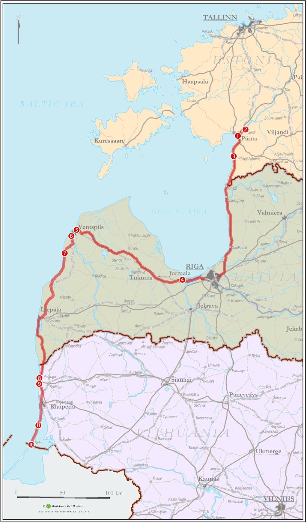
5 Program Monday (Sept 10) Registration Introduction of the program (Alar Rosentau) The Archaeology of sea-level change and submerged landscapes (Geoff Bailey) Coffee break Stone Age coastal settlements in Eastern Baltic (Aivar Kriiska) Lithuanian coast of the Baltic Sea: geological structure, development and recent geological processes (Albertas Bitinas) Lunch Resource utilization by prehistoric people at the coastal zone of the eastern Baltic (Lembi Lõugas) Poster session (participants of the Training School) Tuesday (Sept 11) Submerged prehistory and SPLASHCOS project (Geoff Bailey) Problems of reconstruction of the Baltic Sea level fluctuation during Late Glacial and Holocene (Albertas Bitinas) Coffee break Relative sea level indicators and reconstructions in Estonia (Alar Rosentau) Ground-penetrating radar in archaeology (Jüri Plado) Lunch Early settlement in Pärnu area (Aivar Kriiska) Stop 1 and Stop 2 Field Trip to visit Stone Age settlements and buried peat layers in Pärnu area (Aivar Kriiska, Alar Rosentau) Wednesday (Sept 12) Field Trip from uplifting to subsiding coast: Pärnu-Riga-Ventspils Stop 3. Tolkuse mire and Rannametsa dunes (Alar Rosentau) Lunch in Lido, Riga Stop 4. Priedaine Neolithic site and its palaeoenvironment (Valdis Berzins, Guntis Eberhards, Laimdota Kalnina) Stop 5. Outcrop of buried gyttja and peat layer, hoard findspot at Staldzene (Laimdota Kalnina, Valdis Berzins) Overnight in Ventspils Seaside Camping Thursday (Sept 13) Field Trip from uplifting to subsiding coast: Ventspils-Nida Stop 6. Archaeological excavations of Lapini Mesolithic settlement near Sarnate (Valdis Berzins) Stop 7. Buried gyttja and peat layer at Baltic Sea Bluff near Sarnate Neolithic settlement (Laimdota Kalnina, Valdis Berzins) Lunch in Grobina Stop 8. Litorina and Post-Litorina Sea terraces near Palanga (Aldona Damusite) 5
6 Stop 9. Neolithic settlements near Palanga (Sventoji) (Algirdas Girininkas, Vladas Zulkus) Overnight in Jurate Hotel, Nida. Friday (Sept 14) Field Trip from uplifting to subsiding coast: Nida Stop 10. Parnidis dune and lagoon marl exposure (Aldona Damusyte) Lunch in Nida Stop 11. Buried soils in the Grey (Dead) Dunes nature reserve (Albertas Bitinas, Nikita Dobrotin) Seminar and closing of the training school (Alar Rosentau) Overnight in Jurate Hotel, Nida. Saturday (Sept 15) Transport from Nida via Riga Airport to Tartu 6
7 7
, on the eastern coast of Gulf of Riga, is characterized by slow post-glacial")
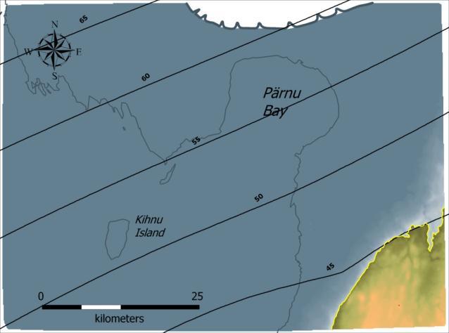
8 Stop 1 and Stop 2: Stone Age Settlements and Buried Peat Layers in Pärnu Area Aivar Kriiska 1, Alar Rosentau 2 1 Institute of Archaeology, University of Tartu, Lossi 3, Tartu, Estonia 2 Institute of Ecology and Earth Sciences, University of Tartu, Ravila 14A, Tartu, Estonia The study area in SW Estonia (Fig 1), on the eastern coast of Gulf of Riga, is characterized by slow post-glacial isostatic uplift (apparent uplift about 1mm/yr) and slowly undulating low topography. Therefore, even small increases of sea-level can easily lead to flooding of substantial areas. The complex deglaciation history of the Baltic Sea area, with up-dammed lakes and early phases of post-glacial seas has, at times, left southwestern Estonia submerged, while at other times, it has emerged as terrestrial land. Therefore, transgressive deposition of water-laid sediments of the Ancylus Lake and the Litorina Sea have led to repeated burial of soil, peat and gyttja deposits and associated settlement layers (Fig. 2.). The Pärnu area is rich in sites from different prehistoric periods. Coastal habitation is characteristic of the Stone Age. The Pulli, Sindi-Lodja I and II and Jõekalda settlement sites in the lower reaches of the Pärnu River and the Malda, Lemmetsa I and II settlement sites in the lower reaches of the Audru River are important in this context. Several vertical sections studied in Pärnu area provide high-resolution records for bio-and chronostratigraphical, geological, archaeological and palaeogeographical reconstructions of the interaction of man and environment during the early phases of the Baltic Sea in the area. Fig 1. Study area in SW Estonia 8
. Pulli and Sindi-Lodja are Stone Age settlement sites.")

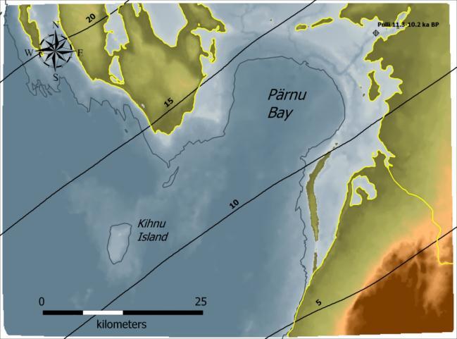
9 Fig. 2. Location of study sites in the Pärnu area and a simplified geological cross-section. Buried organic matters represent either the pre-ancylus Lake and/or pre-litorina Sea lowstand and terrestrial accumulation (peat/cultural layers). Pulli and Sindi-Lodja are Stone Age settlement sites. Fig 3. The Holocene shore displacement curve for SW Estonia was constructed on the basis of coastal landform elevations and 14C dated buried peat and soil sequences below Ancylus and Litorina sediments. The curve displays three regressive phases of the past Baltic Sea interrupted by the Ancylus Lake ( cal ka BP) and the Litorina Sea transgressions ( cal ka BP) with magnitudes 12 m and 10 m The use of digital terrain models (DTM) and GIS-based spatial calculations has opened up new perspectives for the reconstruction of palaeo-water bodies in formerly glaciated areas. Palaeoreconstructions are based on spatial calculations in which glacioisostatically deformed water-level surfaces are subtracted from the DTM. Palaeo water level surfaces were calculated for relavant time periods by interpolation in space and time using late glacial and Holocene shoreline databases. Combination of geological, geodetic and archaeological shore displacement evidence was used to create a temporal and spatial water-level change model for the SW Estonian coast of the Baltic Sea since 13,300 cal. years BP. The Baltic Sea shoreline database for Estonian territory was used for the modelling work and contained about 1,200 sites from the Baltic Ice Lake, Ancylus Lake and Litorina Sea stages. This database was combined with a shore displacement curve from the Pärnu area (Fig. 3) and with geodetic relative sea-level data for the last century. The curve was reconstructed on the basis of palaeocoastline elevations and radiocarbon-dated peat and soil sequences and ecofacts from archaeological sites recording three regressive phases of the past Baltic Sea, interrupted by Ancylus Lake and Litorina Sea transgressions with magnitudes of 12 and 10 m, respectively. 9


10 a b c d e f 10
 the Baltic Ice Lake during the deglaciation of the Pärnu area and formation of the end-moraines of the")
 Ancylus Lake at the beginning of the transgression and during the Pulli settlements at about 10,500 cal.")
11 g Fig 4. Palaeogeographical reconstructions of the Baltic Sea coastline during different stanges: (a) the Baltic Ice Lake during the deglaciation of the Pärnu area and formation of the end-moraines of the Pandivere-Neva ice marginal zone at about 13,300 cal. years BP, (b) the Baltic Ice Lake after the Billingen drainage at about 11,600 cal. years BP, (c) Ancylus Lake at the beginning of the transgression and during the Pulli settlements at about 10,500 cal. years BP, (d) Ancylus Lake during its maximum in the Pärnu area at about 10,200 cal. years BP, (e) the Litorina Sea before the transgression and during the Sindi-Lodja I and II settlements at about 9,000 cal. years BP, (f) the Litorina Sea during its maximum in the Pärnu area at about 7,300 cal. Years BP, (g) the Litorina Sea after the transgression and during the Lemmetsa, Malda, Jõekalda and Sindi-Lodja III settlements at about 6,000 cal. years BP Pulli is the oldest known human occupation in Estonia and it is dated to the Early Mesolithic cal ka BP. Pulli was situated on the ancient Pärnu River, a few km from the Ancylus Lake but is now 15 km from the present sea shore. By the character of soil and find material it is assumed, that Pulli was a seasonal hunting and fishing camp. Bone material is well preserved and typical of the hunter-fisher-gatherer economy with dominance of elk and beaver bones. Pulli site was buried under the transgressive Ancylus Lake sediments. 11 Fig 5. Pulli settlement site The site of Sindi-Lodja II is located on the left bank of the Pärnu River, approximately 400m upstream from the mouth of the Reiu. The cultural level, alternating with layers of sand, is located on the steep river-bank, about six metres lower than today s ground level. The find material obtained from the small area excavated was relatively rich. It is not clear, if the site was inhabited seasonally or year-round. Compared to Pulli, ringed seal is more represented in the bone material, indicating the growing importance of seal hunting. The radiocarbon dates obtained from the wood gathered from the cultural layer gave a result of cal ka BP, i.e. the Middle Mesolithic. Sindi-Lodja II was buried under the transgressive Litorina Sea sediments.

 Stone age settlement sites on an environmentally sensitiive coastal area along the lower reaches of the River Pärnu (south-western Estonia), as indicators of")
12 Fig 6. Sindi-Lodja II settlement site Most tools found in the Stone Age sites in Pärnu area are made of flint. At Pulli, the flint is of high quality, often (brownish) black. It is most probably from southern Lithuania, Belorussia or the Ukraine. During Middle/Late Mesolithic also local, low quality Silurian flint tools were used. Fig 7. Different artefacts from sites in the Pärnu area. References Kriiska A, Lõugas L (2009) Stone age settlement sites on an environmentally sensitiive coastal area along the lower reaches of the River Pärnu (south-western Estonia), as indicators of changing settlement patterns, Technologies and economies. In: McCartan SB, Schulting R, Warren G, Woodman P (eds) Mesolithic horizons:papers presented at the 7th International conference on the Mesolithic in Europe, Belfast Oxbow Books, Oxford, pp Rosentau, A., Veski, S., Kriiska, A., Aunap, R., Vassiljev, J., Saarse, L., Hang, T., Heinsalu, A. 12

13 & Oja, T. 2011: Palaeogeographic model for the SW Estonian coastal zone of the Baltic Sea. In Harff, J., Björck, S. & Hoth, P. (eds.): The Baltic Sea Basin, Central and Eastern European Development Studies, Springer-Verlag, Berlin. Veski, S., Heinsalu, A., Klassen, V., Kriiska, A., Lõugas, L., Poska, A. & Saluäär, U. 2005: Early Holocene coastal settlement and palaeoenvironment on the shore of the Baltic Sea at Pärnu, southwestern Estonia. Quaternary International 130, Stop 3. Tolkuse Mire and Rannametsa Coastal Landforms: Holocene Water-level Changes on the Slowly Uplifting Coast of SW Estonia Alar Rosentau, Tiit Hang, Marko Kohv, Hando-Laur Habicht Institute of Ecology and Earth Sciences, University of Tartu, Ravila 14A, Tartu, Estonia Geological data from Rannametsa coastal landforms and Tolkuse mire reflects the Holocene water level change history of the past Baltic Sea and will be discussed together with other shore displacement evidences from SW Estonian coast during the excursion (Fig 1). Fig 1. Geological cross-section of the Rannametsa coastal landforms with datings (uncalibrated 14 C years) and Tolkuse mire (after Hyvärinen et al., 1992). The Tolkuse mire (5500 ha) is locating between the Ancylus Lake and the Litorina Sea (Rannametsa) coastal ridges (Fig. 1). An 8 m long sediment core from the southern part of the mire, was investigated and preliminary results of lithostratigraphy, loss-on-ignition, diatom analysis and radiocarbon dates were used and applied with digital terrain model to reconstruct 13

14 the evolution of the area. We discovered a 0.20 m thick peat layer buried under the layer of fine sand and gyttja which is covered by Carex peat (Fig. 2). Two radiocarbon dates from the buried peat layer indicate the pre-litorina Sea lowstand at about cal ka BP. This is the lowermost known buried peat layer in SW Estonia reflecting the pre-litorina Sea low water level stage. Diatom analysis confirms that the silt layer below the peat contains large lake diatoms, such as Ellerbeckia arenaria and Aulacoseira islandica, typical to the Ancylus Lake freshwater environment. The sandy deposits above the peat contain already diverse assemblage of the littoral brackish-water diatoms indicating deposition in the Litorina Sea shallow lagoon (Rosentau et al., 2010). The sandy deposits are interbeded with thin peat layers characteristic to the transgressive sediments of the Litorina Sea found elsewhere in SW Estonia. Transgressive sands are covered by thick layer of gyttja deposits containing a mixture of planktonic and littoral brackish-water and marine diatoms suggesting basin with deeper water column and higher salinity. The gyttja is overlain by younger Carex type peat. The onset of peat formation is dated to ca. 4.2 cal ka BP (Fig. 2). Fig 2. Buried peat layer and results of LOI and radiocarbon dating (uncalibrated 14 C years) from the Tolkuse sediment core of Palaeogeographic reconstruction shows that the study area has been flooded by transgressive waters of the Ancylus Lake at about 10.2 cal ka BP. and the palaeocoastline was located east of the Tolkuse mire at an altitude of 10-7 m a.s.l. During the Ancylus Lake regression the coastline retreated to the west from the Tolkuse mire and stopped probably close to the present-day shoreline (Fig. 1). Hyvärinen et al. (1998) described a section of peat and clayey gyttja (3-4 m a.s.l.) buried under the sandy deposits of the Litorina Sea at Rannametsa (Fig. 1). Earlier radiocarbon dates from Rannametsa and our dates from Tolkuse mire show the simultaneous formation of the buried peat deposits at about cal ka BP and indicate the emergence and formation of wetland in Tolkuse area. The Litorina Sea transgression in the study area started at about 8.2 cal ka BP. During the transgression the coastal ridges at Rannametsa formed, damming up the Tolkuse lagoon. Sandy deposits alternating with thin peat layers formed in the lagoon in shallow water conditions with active wave regime and erosion of older organic deposits. Stabilized shoreline position at Rannametsa during the transgression initiated probably the dune 14
15 formation on top of the coastal ridge. At the time of the culmination of the Litorina Sea at about 7.3 cal ka BP, 20 km long and 5 km wide lagoon developed in Tolkuse area. The water-level in the lagoon was about 8 m a.s.l. in the north and about 6 m a.s.l. in the south and the water depth was up to 5 m. Our reconstructions show that Tolkuse lagoon had two passages: one in the north and another in the south. The northern passage was about 2 km wide and functioned initially as a main connection route with the Baltic Sea basin. Palaeogeographic reconstructions show that the northern passage was the first to close at about 6.0 cal ka BP due to the more intense land uplift. Radiocarbon dates from our sediment core suggest, that brackish water lagoon existed in Tolkuse area for 4000 years and terminated before 4.2 cal ka BP. References Hyvärinen, H., Raukas, A., Kessel, H. (1998) Mastogloia and Litorina Seas. In: Raukas, A. and Hyvärinen, H. (eds.) Geology of the Gulf of Finland, pp (in Russian with English summary) Rosentau, A.; Hang, T.; Heinsalu, A.; Kohv, M. (2010). Holocene development of the Baltic Sea in Tolkuse area, SW Estonia. In:. (Eds.) Lorenz, S.; Lampe, R.Ice, water, humans - Quaternary landscape evolution in the Peribaltic region: 12th Annual meeting of the INQUA Peribaltic working group, Greifswald, Germany, Sept 2010., 2010, Stop 4. Priedaine Neolithic Site and its Palaeoenvironment Valdis Berzins 1, Guntis Eberhards 2 and Laimdota Kalnina 2 1 University of Latvia, Institute of Latvian History, 2 University of Latvia, Faculty of Geography and Earth Sciences Geology Priedaine Stone Age settlement is located on the slope and the foot of flat dune wall, approximately 1.3 km to the east from Priedaine railway station and 0.6 km from right bank of Lielupe River (Fig. 1). Dune ridge from the mainland has border with Littorina Sea Babītes - Spilves meadow lagoonal plain and Slēpere Mire from the east. There are two peculiarities of the relief according the geological structure at the Priedaine Stone Age settlement: dune ridge and lagoonal plain. Palynological investigations of sediments in core 20 in the locality of Priedaine Stone Age settlement (Kalnina at al., 2009) shows organic sediments accumulation in lagoon start at the middle part of the Holocene about 6500 years ago. Landscape was relatively open during that time area mainly covered with sedge and grass, but in the dry places broad-leaved and alder forest was distributed. Accumulation conditions have been changed in Priedaine lagoon. Gyttja with sand and silt layer and presence of salty water diatom species indicates frequent sea water 15
16 inflow in the lagoonal lake. This feature perhaps was related to sea water level fluctuations and storms. Lagoonal lake gradually becomes filled in and gyttja layer was covered by sedgesphagnum peat during the Late Holocene about 3500 years ago. Ruderal and cultivated land herb pollen indicates man presence and activities in the area since the beginning of organic sediment accumulation period. Especially intensive accumulation has been during the Middle and Late Holocene, but later it decreased. Data of plant macroremain analysis demonstrates aquatic plant presence in whole section ( m). Four macroremain complexes are divided (Fig. 2). Fig. 1. Location of the Priedaine archaeological site and relief map of the area. Ia dominance of terrestrial plants, depth interval of zone corresponds to AT2 pollen zone in diagram. Ib Ruppia maritima presence among aquatic plants (beginning and middle part of the Late course of the climatic optimum). Well preserved seeds of aquatic plant Widgeon Grass (Ruppia maritima) occur in almost whole interval m. Plant is distributed in salty sea water in depth to 1.4 m. In Latvia it usually grows together with Soft Hornwort or Tropical Hornwort (Ceratophyllum submersum) and Horned Pondweed (Zannichellia palustris) in the protected area of Randu meadows located at Vidzeme coastal area of the Gulf of Riga. Seeds of these plants occur as well in this depth interval (Ceratophyllum submersum up to 1.6 m). Ruppia maritima and Ceratophyllum submersum haven t been found above depth 1.4 m. This fact probably 16
17 indicates that sea water didn t flow into lagoon anymore during next phase of lagoon development and water became less salty and unsuitable for growing of these plants. Ic aquatic plants Nymphaea alba, Zannichellia palustris, Najas marina, N. flexilis and increase of mire plant remains (end of climatic optimum, beginning of the Late Holocene). Fig. 2. Plant macroremain diagram from Priedaine site. Analysed by Aija Cerina. II dominance of terrestrial plant remains (end of SB, SA). Sharp decrease of aquatic plant species and plant remains as well increase of mire, wet meadow and other terrestrial plants can be observed in the upper part of section ( m). That point on rapid paludification of area and overgrowing of water basin. Only two aquatic plant remains have been found in depth interval m, but above this interval just mire plants. Data of both pollen and macroremain analysis indicate Priedaine lagoon development since the middle part of the Holocene climatic optimum until end of it. Lagoon became as lake during the first part of the Late Holocene and continues to fill in and mire has been developed in the area of the former Littorina Sea lagoon during the Late Holocene. Archaeology Already in 1975, the local museum in the seaside town of Jūrmala was given some Neolithic artefacts found in the woods at Priedaine. However, it was not until many years later that the site came to the attention of Stone Age researchers. In 2007 the first trial excavation was conducted at the site by the Institute of Latvian History under the direction of Valdis Bērziņš (Fig. 3). Twelve test-pits were excavated on the slope of a dune and at the edge of the adjacent boggy plain. In the test-pits on the dune slope, a Neolithic occupation layer was found in the sand 17
18 layers, and in Test-pit 12, at the foot of the slope, archaeological material was recovered in a layer of sandy fen peat. The finds include sherds of Comb Ware, flint tools and debitage, two amber pendants, worked and unworked pieces of amber, a miniature stone chisel, a whetstone and two unworked pebbles, probably used as net sinkers. In Test-pit 12, wooden laths and the tip of a stake were found thought to be remains of Neolithic fishing gear (Fig.4). Excavation continued in 2008 in collaboration with the Roman-Germanic Commission of the German Institute of Archaeology (Frankfurt), this time focusing attention on the wet part of the site at the foot of the dune slope. Test-pit 12 was extended into a small excavation area (2 3 m). This area was excavated in 5 cm spits, and all the excavated earth was wet-sieved. It turned out that the steep slope of the dune continues under the peat. The stratigraphy in the excavated area consisted of peat layers that had accumulated in the course of terrestrialisation of a former lake, alternating with layers of peaty sand, i.e. sand eroded from the upper part of the sandy slope and redeposited at the edge of the bog. The area was excavated to a maximum depth of 0.9 m. The finds continued in the gyttja layer beneath the peat, but the rapid inflow of water and time shortage prevented complete excavation. Structural remains were not observed (only the end of one pile), but there were fragmentary artefacts scatted in the peat and sand layers. It was concluded that the settlement itself had been further upslope, and that the wetland part of the site represents the former shore zone of the lake, where occupation refuse accumulated. Some unusual wooden artefacts were discovered: one of them was a long, very regular stick of semicircular section, with oblique grooves cut into the rounded side, whereas the other side was flat. Its function remains unknown, since no archaeological or ethnographic parallels have been identified. Many sections of pine wood laths were also recovered, two of them wound with birch bark strips. These are evidently remains of fish fences, such as have been found at many other Neolithic sites in north-eastern Europe. The pottery recovered at Priedaine includes sherds from mineral-tempered and shell-tempered vessels, decorated with comb, wound cord and other impressions. The pottery shows strong Comb Ceramic influence, but also features going back to the Early Neolithic ceramic tradition of the East Baltic. Food remains include hazelnut and water chestnut (Trapa natans) shells, fish scales and some poorly preserved animal bone. Five AMS radiocarbon dates have been obtained from macrofossil samples taken from the wetland part of the site. They cover the period approximately cal. BC, i.e. the earlier part of the Middle Neolithic. The shoreline at this time would have been about 1 m above present sea level. Fieldwork and analysis was supported by Jūrmala Town Council, the Culture Capital Foundation of Latvia and the Roman-Germanic Commission of the German Institute of Archaeology. 18


19 Fig.3. Excavation at Priedaine, 2008 Fig.4. Finds from Priedaine: wooden artefact of unknown function, amber pendant, Comb Ceramic sherd. 19

20 Stop 5. Outcrop of buried gyttja and peat layer, hoard findspot at Staldzene Laimdota Kalnina 1 and Valdis Berzins 2 1 University of Latvia, Faculty of Geography and Earth Sciences, 2 University of Latvia, Institute of Latvian History Geology The Staldzene outcrop is located at the Baltic Sea is typical abrasion cliff, length about 4 km from accumulative shore near Ventspils harbour to the Busenieks Lake at the north. The abrasion cliff outcrop has the altitudes 8-12 m above sea level. It occurred in the result of along coastal stream erosion activity, which increases after construction of the Ventspils harbour jetty. Nowadays each storm takes away several meters of deposits from outcrop. Therefore earlier investigated sections already are washed away by sea, which have been investigated by I. Veinbergs (1999), Z. Meirons (Meirons et al., 1985), A. Cerina, E. Bulgakova (1985). The sediment sequence at the outcrop southern Staldzene site are formed under conditions of the different Baltic Sea stages and overlie grey till of the last glacial (Fig. 1). Sediment structure can be characterised as follow: bluish-grey silt, silty clay and fine sand, large bed of the lacustrine deposits represented by the gyttja, peat and eolian sand (Cerina, Bulgakova, 1985; Savvaitov, A. et al., 1998). Fig. 1. Geological longitudal section of the Staldzene outcrop. 20
21 Sediment sequence has been analysed by lithological, paleobotanical methods (Veinbergs, 1996), as well as dated by 14 C. The underlying sediments of the Ancylus Lake contain Selaginella selaginoides (L) Link. The remains of Zannichellia palustris L. have been found among plant macrofossils in the Ancylus Lake sediments. There have been found the plant macroremains of Betula alba L., Pinus sp., Picea sp., Potamogeton filiformia Pera, Carex spp., Alnus glutinosa (L) Gaertn., Rubus idaeus L., Menyanthes trifoliata L. etc.these sediments contain the remains of the wood, fossils and plants. The wood was dated at cal years ( C years Tln 706) BP. This date allow to suggest that characterized sediments were formed at the beginning of the Ancylus Lake transgression. Palynological data indicate that the bed of the organic deposits (peat, gyttja, sand with remains of plants) formed during the climatic optimum and it ending part, but underlying sand and bluish-grey silt and silty clay - during the before climatic optimum, probably during Ancilus Time. The wood from gyttja of Staldzene outcrop was radiocarbondated at 6873 cal. years ( C years) BP. Gyttja from the Staldzene outcrop contain diatoms, predominantly represented by freshwater planktonic species: Aulacosira ambigua,a. granulata, Stephanodiscus astrae var. minutulus, and S. astrae var. intermedia. In the section have been found also large diverse of benthos species, however in small amounts. Opephora marthyi, Fragilaria brevistriata, F. construens var. construens et var. binodis, et var. venter, F. inflata, Cocconeis placentula, Epithemia zebbra, E. sorex u.d.c. has been found more frequently. There have been found also species characteristic for gyttja Cocconeis disculus disculus et var. diminuta, Synedra parasitica. In small numbers (17 species, 7% from total amount) have been found very well preserved brackish species like Navicula forcipata, Diploneis smithii var. smithii et var. rhombica. These data allow suggesting frequent sea water inflow in the basin. In the silt above gyttja have been stated 14 mesohalobous taxa, including some species for the first time: Nitzschia scalaris, Campylodiscus clipeus, C. echeneis, Synedra tabulata, Diploneis interrupta, Naaviculaa humerosa, N. paregrina. Marine species like Diploneis smithii var. smithii et var. rhombica and D. didyma have been found in significant amounts, which allow suggesting that silt overlying have been formed under conditions of frequent marine water presence. The most possible it can take place during a transgression of the Littorina Sea. Nowadays lagoonal and alluvial sediments appear at the coastal outcrop due to coastal erosion, which increase after building of Ventspils harbour jetty. 21

, a total of 5.6 kg of bronze.")
22 Fig.2. Gyttja and peat layers at the Staldzene site and waterfalls Archaeology The stormy weather of early November 2001 eroded part of the coastal sand cliff at Staldzene, revealing a large number of bronze artefacts: the Staldzene Hoard. This is the largest deposit of Bronze Age artefacts ever discovered in the territory of Latvia. When all the material was brought together, there was an impressive array of finds: 174 bronze artefacts and fragments (around 80 items after refitting of the fragments), a total of 5.6 kg of bronze. In the Bronze Age, bearing in mind that the territory of Latvia was far from the metallurgical centres of the time, bronze reached the area in limited amounts, and such an amount of metal represents as an immense quantity, possibly even a priceless treasure. Up to the finding of the Staldzene Hoard, only 165 bronze artefacts from the Bronze Age had been found in Latvia. Judging from the artefact forms, we may conclude that they were made at the end of the Bronze Age, around BC. Bronze the precious metal of the time was a material used to make ornaments as weapons that served as a special indicator of wealth and social status. The largest section of the hoard consists of ornaments broken already in antiquity neck-rings, armband-like rings, armbands, a so-called belt box, a brooch, dress-pins etc. Predominant in the hoard, also in terms of weight, are 32 cast rings resembling armbands with open terminals, which have not been further worked. These can only nominally be classed as ornaments. It has been suggested that they served as a means of payment: these valuable bronze castings were used in the exchange process and as a form for storing the metal. One of the largest and most impressive ornaments is a spiral armband with 25 windings, with terminals rolled back in an S-shape. (A second similar spiral armband is preserved in fragmented form.) There are also several broken ornate neck-rings with broad oval terminals, decorated with an unusual linear design. Most of these ornament forms have never been found in Latvia before. These include the dress-pins with circular and flat spiral terminals, a spectacle-shaped brooch, neck-rings twisted in opposed directions etc. Other unusual artefacts include a dress-pin with a 22

23 solid, realistically formed ram s head and fragments of hollow circular objects, regarded as parts of an ornate harness. Almost all the ornaments that are unique in Latvia have direct parallels in the Scandinavian countries, particularly in Denmark and Sweden. The character of the hoard suggests that the artefacts were being brought over for re-melting. The impression is that worn out and broken ornaments, which were still valuable because of the bronze they were made of, were brought here by Scandinavians as a valuable raw metal. The artefacts are now kept in Ventspils Museum. Fig. 3. Artefacts of the Staldzene Hoard References: Cerina, A., Bulgakova, J., New data about Littorina Sea deposits at the Staldzene outcrop. Symposium of Baltic State Quaternary geologists. Jurmala, Latvia. [in Latvian] Meirons Z. et al., Quaternary deposits. Geomorphology. Report of geological mapping in scale 1: at the territory of Ventspils map г. Latvian Geological Funds [in Russian]. Savvaitov, A., Veinbergs, I., Kalniņa, L., Ceriņa, A., Jakubovska, I., Stelle, V., 1998.Staldzene. In: Environmental perspectives of sensitive southeastern Baltic coastal areas through time. In the coastal areas of the Latvia. NorFA course Field guide (Compiled by L.Kalniņa, A.Andrušaitis, A.Briede; Contributors to the guide: V.Bērziņš, A.Ceriņa, G.Eberhards u.c.) pp. Veinbergs, I., Baltic basin development during the Late Glacial and the Holocene according investigation materials from coastal area of Latvia and adjacent area. Report. Fund No of Geological Institute of University of Latvia [in Latvian] 23


24 Stop 6. Archaeological Excavations of Lapini Mesolithic Settlement Near Sarnate Valdis Berzins University of Latvia, Institute of Latvian History On September 6 22 an excavation directed by Valdis Bērziņš and Inga Doniņa from the Institute of Latvian History will be undertaken at the Lapiņi complex of archaeological sites in the forest north of the village of Sārnate. A new forestry road was built here in 2011, and in the course of survey work flint artefacts were found in the ditches along the road, indicating that this is a Mesolithic site. In further survey work, a number of burnt bronze and iron objects (fragmentary neckrings, armbands, brooches, axes) were also discovered: it turns out that on this same site there is a Late Iron Age / Medieval cremation cemetery, a typical burial site of the Couronians, a Baltic group. The main aims of the excavation are: to determine the extent of the site and the state of preservation of the Stone Age occupation layer and the cremation graves, to obtain radiocarbon samples for dating the Stone Age occupation and to study the Couronian burial practices. The Mesolithic site Lapiņi I is located at a height of approximately 10 m above present sea level. If it is a shorebound site, then it must correspond to a high transgression phase of the Littorina Sea (or Ancylus Lake?). Another site, Lapiņi I, which has so far produced only two flints, lies at a height of 8 m above present sea level. These sites are on a spit of land that separated the open waters from the Ventspils Lagoon presumably an advantageous site for fishing and seal hunting. Fig.1. Bronze jewellery and iron axes from the Couronian cremation graves at Lapiņi 24
25 Stop 7. Buried Gyttja and Peat Layer at Baltic Sea Bluff Near Sarnate Neolithic Settlement Laimdota Kalnina 1 and Valdis Berzins 2 1 University of Latvia, Faculty of Geography and Earth Sciences, 2 University of Latvia, Institute of Latvian History Silt and silty sand with a small amount of organic matter was laid down in the area of the presentday Sarnate Mire area during the Younger Dryas, with the fall in the level of the Baltic Ice Lake. The area contained one or more shallow coastal lakes, which were cut off from the open water of the lake on the western side by a narrow ( km wide) spit of land during the Ancylus Lake, when sea level was about 4-5 m higher than present one. The freshwater lime accumulated in some places of lakes, and on their shores thin peaty layers of gyttja were formed. During the Littorina transgression at the beginning of the Atlantic Time, seawater entered the low-lying area in the surroundings of Sarnate and other stretches of the coastline with lower topography, and reached a height above present sea level of 5-6 m. This formed a large, shallow lagoon, which was cut off from the sea through the process of long-shore drift. The water level during the Littorina transgression fell and the lagoon rapidly divided into separate lakes, which became overgrown, and mires were formed. Organic sediment layers formed in Sarnate area during the Holocene nowadays become revealed due to coastal erosion. It allows studying these sediment sequences at the coastal cliff of the Baltic Sea (Fig.1). The lowest part of the outcrop is represented by sandy and silty sediment layers, which have particular water-escape structures (Fig.1). Large water-escape structures are present in alternating silt and sand beds, up to 2 m thick. These structures occur in 2-3 levels and their maximum vertical amplitude reaches 1 m. These structures probably have formed under pressure of glacier, which extruded pore-water from sediment and initiated its upward migration together with loose material. The water-escape structures have been overlaid by organic deposit layer represented mainly by peat of different decomposition level. The lowest part ( m) represented by various coarse sand with very well decomposed wood-grass peat, containing fragments of wood (some charred pieces), as well as remains of grass and Bryales. The admixture of sand decrease in the peaty gyttja in the section upwards ( m). It contains wood remains, as well as Carex nuts and Menyanthes trifoliata seeds. In the upper part seeds of Potentilla and other plants increase. This layer is covered by low decomposed Hypnum sedge peat (depth m) with pressed structure and contains Carex sp. nuts and seeds of Menyanthes trifoliata. The deposit layer at the depth m is represented by low decomposed Hypnum reed peat, which upwards ( m) covered by Hypnum peat with wood and reed remains and seeds of Menyanthes trifoliata. The peat layer at the depth interval m is medium decomposed grass-sedge, which contains Carex sp. nuts and some Menyanthes trifoliata seeds. The very upper layer of organic deposits (depth from surface m) represented by well decomposed grass peat contains nuts of Carex sp., seeds of Cladium mariscus, Menyanthes trifoliata, Potentilla and large number of insect remains. This peat layer is covered by eolian sand. 25
 that characterised the early part of the Holocene Climatic")

26 Fig. 2. The water-escape structures of sand and silt covered by organic deposit layer at the Baltic Sea Cliff near the Sarnate. The pollen analysis show that well decomposed wood-grass peat layer had a pollen spectrum (significant amount of Alnus, Corylus, Ulmus) that characterised the early part of the Holocene Climatic Optimum, which is confirmed by the 14 C dates (Fig.2). Hypnum-sedge peat accumulated, providing pollen spectra characteristic of the vegetation of the climatic optimum with highest amount of broadleaved trees - Ulmus, Tilia, Quercus. The very upper part of this layer probably was formed at the end of the Climatic optimum Time what has proved by pollen spectra with significant proportions of Quercus and Alnus pollen, and Carpinus is also recorded. Pollen spectra from the very upper grass peat layer indicate that probably peat has been formed during the Late Holocene, because of decrease of warm demanding plant pollen in comparison with lower layer and maximum of Picea pollen. The organic deposit layer in depth interval 2.7 to 2.2. m from the surface contains pollen anthropogenic indicators Plantago major/media, Chenopodium album, Polygonum aviculare, Urtica and Rumex acetosella. The plant macroremain, pollen and 14 C dates indicate that layer of organic deposits from the cliff at Sarnate has been formed during time span from the early part of Atlantic Time to the Subboreal and are some part of former Littorina Sea lagoon 26
 Aldona Damušyte 1, Albertas Bitinas 2, Algirdas Girininkas 2,")

27 Fig. 2. Generalised pollen percentage diagram from Sarnate outcrop sediments. Stop 8 and 9. The Baltic Sea Terraces and Neolithic settlements in the Northern Part of Lithuanian Coastal Area Near Palanga (Sventoji) Aldona Damušyte 1, Albertas Bitinas 2, Algirdas Girininkas 2, Vladas Zulkus 2 1 Lithuanian Geological Survey 2 Klaipéda University The best expressed geological records of the Baltic Sea development terraces of the Baltic Ice Lake, Litorina Sea and Post- Litorina Sea are developed in the northern part of the Lithuanian Maritime region, north from Palanga resort (Fig. 1) A number of investigations associated with geomorphological and geological structure of mentioned terraces as well as problems of development of the Baltic Sea basin have 27
28 been done in the mentioned coastal area (Gaigalas 1996; Gudelis, 1979, 1997; Kabailienė, 1959 and others). The Lithuanian coastal area was situated in the transitional position concerning to general tectonic situation of the entire Baltic Region during lateglacial and Holocene: the northern part was uplifted due to glacioisostatic rebound while the southern part experienced submerging. Presently the mentioned terraces indicating the different stages of the Baltic Sea development has an obvious regional trend uplift towards to the north (Gudelis, 1979). Thus, the surface of the Baltic Ice Lake terrace increases from about m a.s.l. in the vicinity of Palanga to m a.s.l. close to the Lithuanian Latvian state border. In some localities the flat surface of the mentioned terrace was influenced by aeolian processes: a few meters-high dunes are developed. According to the results of optically stimulated luminestence (OSL) dating the aeolian activity started about 8-10 kyr BP. The prominent m high and up to 200 metres wide beach ridge marks the maximal limit of the Littorina Sea transgression. The Litorina Sea terrace is situated at the altitude m a.s.l., gently inclining westwards. This terrace is better presented northwards from Šventoji River. The Post-Litorina Sea terrace is situated from +4 m a.s.l. northwards to Palanga up to +0.3 m a.s.l. in the vicinity of the Šventoji resort. The detailed morphological investigations carried out in the northern part of Lithuanian coastal area indicate that terraces of the Baltic Ice Lake, Litorina Sea and Post-Litorina Sea have not only regional trend (Gudelis, 1997), but have local deformations as well. The terrace surface of the Baltic Ice Lake has about meters difference in altitude comparing to the flat surfaces of the terrace at both sides of the Šventoji River. The surface of Litorina Sea terrace is deformed as well: the relative difference in the altitudes of terrace surfaces at both sides of the river reaches up to m (Bitinas, Damušytė, 2004). Šventoji River concurs with the Early Palaeozoic Akmenė Fault in this part of the coastal area (Šliaupa et al., 2005). No obvious local deformations were detected in the Post-Litorina terrace, while then terrace have an opposite trend southwards uplift. All these deformations could be related with the neotectonic activity of the Earth s crust blocks during the Holocene. These movements probably have an oscillatory character. NB! During this stop we will have a short presentation about submerged forest in Lithuanian coastal waters at University of Klaipéda. 28
, 2 Litorina Sea (L), 3 Post-Litorina Sea (PL), 4 longitudinal profile of terrace: a location of profile; b morphology of terrace surface; measured altitudes of terrace")
29 Fig. 1. Baltic Sea terraces in the northern part of Lithuanian Maritime region. Terraces: 1 Baltic Ice Lake (B), 2 Litorina Sea (L), 3 Post-Litorina Sea (PL), 4 longitudinal profile of terrace: a location of profile; b morphology of terrace surface; measured altitudes of terrace surface indicated by black dots, 5 tectonic fault References: Bitinas, A., Damušytė, A., The Littorina Sea at the Lithuanian Maritime Region // Polish Geological Institute Special Papers, 11, Gaigalas, A Structure and lithology of the beach ridge of the Baltic Ice Lake in Lithuania // Baltica, 9,

30 Gudelis, V., The Quaternary history of the Baltic. Lithuania // The Quaternary history of the Baltic. Acta Universitatis Upsaliensis. Annum Quingentesimum Celebrantis: 1. Uppsala, Gudelis V., Litorina Maximum Transgression on the Southeast Coast of the Baltic Sea // Baltica, 10, 5-8. Kabailienė M., Lietuvos ir pietinės Latvijos Baltijos pajūrio raida vėlyvajame ledynmetyje ir poledynmetyje diatomėjų floros tyrimų duomenimis // Moksliniai pranešimai. Geologija, Geografija, X, (In Lithuanian). Šliaupa, S., Bitinas, A., Zakarevičius, A., Predictive Model of the Vertical Movements of the Earth s Surface: Implications for the Land Use of the Lithuanian Coastal Area // Social Strategies 40, Stop 10. Parnidis Dune and Lagoon Marl Exposure Curonian Spit Aldona Damušyte Lithuanian Geological Survey The spit of Kuršių Nerija (Curonian Spit) is a 98 km long and km wide sandy barrier in the South Eastern Baltic separating the lagoon of Kuršių Marios (Curonian Lagoon) from the Baltic Sea. The area of Curonian Lagoon is 1584 km 2 with 413 km 2 belonging to Lithuania. The largest depth reaches 5.8 m in the southern part of lagoon, while the average depth is 3.8 m. Administratively the northern half of the Curonian Spit (50 km) belongs to Republic of Lithuania, the southern one (48 km) is in the Kaliningrad region of the Russian Federation. In both parts of the Spit National Parks were established; in 2002 the whole Curonian Spit was included in the UNESCO World Heritage List as an object of cultural landscape with many natural and cultural heritage valuaes. 30

31 The Curonian Spit being a unique natural heritage area represents: natural geomorphological (physiographic) features of the great dune ridge: diversity of dune forms at different stages of formation; separate dune peaks, diversity of blown sand plains, capes and small bays, which are valuable from aesthetic and scientific point of view; sandy beaches, the Baltic Sea coastal dune ridge, and great dune ridge host numerous natural and seminatural habitats of threatened species of animals and plants; the old forests habitats are of outstanding universal value from the scientific and conservational points of view. The Curonian Spit landscape being created not only by natural processes but also by human activities represents the combined work of nature and man. It illustrates the evolution of fisherman society and their settlements over the time: the influence of the physical conditions and opportunities presented by nature on one hand, and further development of natural areas by humans on the other hand. Cultural properties in the Curonian Spit represent: sites (fishermen settlements) where works of man and nature are of outstanding universal value from the ethnocultural, historic and aesthetic point of view; monuments: architectural works, which have an universal historical, aesthetic and scientific value. The Parnidis Dune: Formation of Curonian Spit and Aeolian Activity Albertas Bitinas 1 and M. Stančikaitė 2 1 Section of Quaternary Geology of the Lithuanian Geological Society 2 Vilnius University, Institute of Geology and Geography The Curonian Spit is an inimitable part of Lithuania s landscape without which it would be impossible to imagine the coast of Lithuania. The geology and geomorphology of the Curonian Spit, Curonian Lagoon and adjacent region had been studied by numerous researchers: J. Schumann (1859), G. Berendt (1869), H. von Wichdorff (1919), O. Pratje (1931), V. Gudelis (1959, 1961 and 1976) and others. Detailed investigations of the Curonian Spit and Curonian Lagoon origin and development during Lateglacial and Holocene by pollen and diatom methods started only in the second 31
32 half of 20 th century (Brockmann, 1954; Kabailienė, 1959, 1967, 1990, etc.). These investigations continue until the present-day. In the northern, Lithuanian part of the Spit, the deposits of the Last Glaciation (Late Weichselian) are presented by till and glaciolacustrine clay occurring at altitudes of meters, while in the southern part the till deposits lay at about -2-4 meters, and in the vicinity of Rasytė (Rybachyj) they are a few meters above the present sea level. Most probably, the formation of the Curonian Spit started during the transgression of Ancylus Lake, when the water level was a few meters lower than present, and continued during the Litorina and Post-Litorina Sea stages. Thus, the Curonian Spit is a sandy bar composed generally by marine sand. Eroded coasts of the Semba Peninsula served as a source area for the marine sand. Later the major part of the Curonian Spit surface was occupied by an aeolian sand plain called here palvė. Along the western margin of the Spit there is a protective dune ridge, 6 12 m high and mainly humanmade, and a beach which is still forming. A long range of high dunes, Great Range, is stretching along the eastern margin of the Spit. The dunes are typical for the entire Lithuanian coast, but only in the Curonian Spit the dunes clearly dominate the surface. Since the early beginning of the Spit existence, the aeolian processes play a very important role for its development. They formed the largest and the highest dune formations in North Europe. The dune tops rise up to m; the official highest point in Lithuanian part of the Spit Vicekrugo Hill is 67.2 m high (forested dune). The other similar dune (alive, moving) named Sklandytojų /Glider Flyers/ also reaches m height. The average height of the dunes is about 40 m. Great Range consists of dunes of a few generations: ancient parabolic dunes covered by ancient soils, and new very high, migrating, longitudinal dunes above the first ones. The Juodkrantė and Nida parabolic dunes remained since the end of the Litorina Sea time, i.e. Atlantic period. Now they are overgrown by forest, and their shape is not easily observed. The very interesting and distinctive f dunes are situated between Juodkrantė and Pervalka, where they were not affected by human activity. There are several soil horizons and tree remains buried by the sand. Dunes in this part of the Spit are practically stable, whereas the area close to Nida with the Parnidis Dune is an excellent example of moving dunes. The eastern shoreline of the Spit is very uneven: there are numerous sand peninsulas called by Lithuanians ragas /horn/. The most impressive is Grobšto Ragas with a picturesque Vienišoji /solitary/ Dune. For long centuries, the dunes in the Curonian Spit were freely driven by wind. Only in 19th century the forestation and stabilization of dunes started. Thus, finally, the sand transport from the Baltic Sea side has been interrupted; hence, dunes started to become smaller. 32

33 Parnidis Dune Lagoon Marl Exposure. Phenomenon of Dune Tectonics A. Bitinas 1, A. Damušytė 2, D. Pupienis 3, M. Kabailienė 3, I. V. Buynevich 1 Lithuanian Geological Survey 2 Klaipéda University 3 Vilnius University Southwards from Nida at the bottom of high dune ridge descending into the Curonian Lagoon at the coves of Parnidis Dune and Grobšto Ragas a clayey gyttja is exposed. Since 19 th century German researchers used to call these sediments haffmergel. Analogically, the Lithuanian specialists named it marių mergelis meaning lagoon marl. The lagoon marl is a general name for the mentioned beds because these deposits are not homogenous. The lithological composition varies according to the proportion of organic matter, carbonates and clay particles from clayey gyttja so gyttja clay. Though discovered in many localities along the Curonian Spit lagoon, the marl is known mainly in northern half of the Spit. According to the data of boreholes, as well as results of investigations by ground-penetrating radar (GPR), the lagoon marl occupies an area of at least several square kilometers in the vicinity of Nida. The top of the lagoon marl unit occurring in situ is fixed at a depth from -6.8 to m NN. It is overlain by barrier sands up to 7 10 m thick. The bottom of the lagoon marl dips down to meters below the sea level, i.e. the thickness of theses sediments varies from 5.4 to 9.0 m. The integrated investigation (pollen, diatom, and molluscs analyses, 14 C dating) show that the lagoon marl beneath the present-day Curonian Spit was deposited in a freshwater lagoon. Its sedimentation started, probably, after the Ancylus regression, i.e. more than 9.0 ka BP. The sedimentation continued until the second half of Subboreal. Fig 1. Lagoon marl exposure close to the Lithuanian Russian state border Some lagoon marl sediments are squeezed out above the surface from under the sandy dune ( dune tectonics ) at the base of Parnidis Dune, to the south of Nida. The second and biggest exposure of the lagoon marl is located farther to the south, close to the Lithuanian-Russian state border. The length of this formation reaches up to 700 m, height is 3.5 m, and width is m. There are lagoon marl outcrops as several belts (ridges) extending parallel to the dune ridge. 33
 active development of aeolian processes, i.e. migration of massive sand dunes. The exposures of lagoon marl are caused by a large mass of the dune sand.")
34 Examples of so-called dune tectonics are quite rare in the coastal or inland dunefield areas and are governed by the interaction of two main factors: 1) presence of lagoon marl layers beneath ground water table and 2) active development of aeolian processes, i.e. migration of massive sand dunes. The exposures of lagoon marl are caused by a large mass of the dune sand. The ridge of aeolian sand is slowly moving eastwards and pressing the coast and bottom of the Curonian Lagoon. This caused the deformation of the clayey marl beds occurring under the sand and making their exposures at the surface. The part of the lagoon marl in exposures is eroded by lagoon waves, but the significant part remains for many years, until the dune bottom approaches it and buries later. Then a new belt of marl is being pressed out in the other place of the eastern coast of the Curonian Spit. At present, this geological process is becoming less intensive: the dune height and the rate of migration are decreasing due to lack of sand caused by insufficient sand supply from the seaward sources. The reason is that during the last two centuries the massifs of active dunes and the sea coast were separated by the artificially planted forest along the entire length of the Curonian Spit. In 1964 the outcrop of lagoon marl beneath Parnidis Dune, representing this rare geologicalgeomorphological process, was declared as Lithuanian geological monument protected by law. Fig 2. Lagoon marl outcrop beneath Parnidis Dune, to the south from Nida (photo by J. Satkūnas) 34

35 Stop 11. Buried Soils in the Grey (Dead) Dunes Nature Reserve The Naglis Nature Reserve: aeolian sedimentation and history of human and nature interaction M. Stančikaitė Vilnius University, Institute of Geology and Geography The Curonian Spit separating the Curonian Lagoon from the Baltic Sea is an unique place by its development and human history. Moving sand forms dominated in the relief since the earliest periods of the spit existence. An interaction between the nature and man has played a dominant role in the development of flora and fauna, as well as the Curonian Spit itself. The unique monument of the Curonian Spit development has been found in the sand dune ridge, extending between Rasytė (Rybachyj) and Juodkrantė. A few buried soil horizons corroborated the theory concerning the development of the Curonian Spit relief, human influence in to environment and palaeoecological conditions during the second part of the Holocene period. German naturalist J.Schumann (1859) was the first who has mentioned this fact. G. Berendt (1869), H. von Wichdorff (1919), F. Mager (1938) had prolonged the investigations of the ancient soil horizons. Significantly more data about the development of the dune ridges was given by scientists of Lithuanian Academy of Sciences. V. Gudelis was an initiator of the investigations. Numerous articles in various publications examined this phenomenon (Gudelis 1960, 1986, , Gaigalas et al. 1991, and others). Now the major part of the dune ridge is overgrown by grass and forest and only a few places with open sand afford an opportunity for investigations of the buried soil horizons. These horizons are found northwards from Pervalka between Agila Hill and Vingis Dune on the windward (western) slopes of the dune ridge. Only one soil horizon has been mentioned by H. von Wichdorff (1919), but later up to 7 layers have been excluded. 3 4 horizons are most widely spread and have a stratigraphic significance. The dune ridge in the Curonian Spit is composed of two eolic sand complexes. The lower dunes had been formed as parabolic, the so-called ancient buried parabolic dunes, and the ones had been formed during th century. Soil horizons overlay the surface of the ancient buried parabolic dunes. The buried soils stretch along the western slope of the dunes in the north-south or west-east directions. The slopes of the dunes have been influenced by the wind and part of the sand has been eroded. 35

36 The configuration of the soil layers reflects the shape of the ancient dunes. Even stumps and trunks of huge trees have been found in some places. The high amount of charcoal in soils shows the big fires in the Curonian Spit. The shape of the old dunes, formed by wind was very changeable, and the belts of soil horizons confirmed that. The ancient soil layers are composed of the forest litter of various thickness, podzol horizon, which is composed of grey fine sand, and illuvial horizon which is of reddish or brownish colour due to high content of iron and manganese. The pollen analyses and results of the radiocarbon dating of the soil horizons and pieces of wood confirmed the stratigraphical relationship of the soil layers with the type of flora flourished at the time of the soil formation. Palynological investigations of the soil horizons have been carried out by N. Savukynienė and M. Kabailienė. A sketch map of the distribution of exposed soils in the Kuršių Nerija Spit at Pervalka (according V. Gudelis & N. Savukynienė, 1995) 1 exposed soils, 2 fossils According the results of investigations, three flora complexes have been distinguished. The lowest soil horizon contains the high amount of broad leave trees pollen. Pollen of Tilia reached up to %. Pinus (20 30 %) was a typical tree in forest communities. Betula and Alnus thrived on wet places. Hazel and oak flourished in the territory, Calluna vulgaris pollen are typical for the spectra as well. The forests were luminiphylous with diverse herbs, ferns, and Lycopodium (Gudelis and Savukyniennė, 1995). The middle complex contains the high amount of pine (60 70 %) and spruce (10 20 %). The amount of birch, elm, broad leave trees pollen has decreased. The diversity of herb species in comparison with the older complex has increased. Various spores have been found as well. The upper pollen complex (the youngest one) is very similar to that of the present vegetation. Pine reached up to 90 %, but birch and elm have been diminished from the habitats (10 %). The amount of the spruce pollen is only 3 %. Herbs and spores thrived. 36
THE PROGNOSIS OF CURONIAN SPIT DUNES EVOLUTION AND THEIR PROTECT STRATEGIES BECAUSE OF CLIMATE CHANGE
 THE PROGNOSIS OF CURONIAN SPIT DUNES EVOLUTION AND THEIR PROTECT STRATEGIES BECAUSE OF CLIMATE CHANGE A. Česnulevičius, A. Bautrėnas, R. Morkūnaitė, B. Karmaza Introduction The principal contribution studying
ARCHAEOLOGICAL METHOD FEHMARN STYLE
 ARCHAEOLOGICAL METHOD FEHMARN STYLE Digital archaeology By: Nadja M. K. Mortensen, Prehistoric Archaeologist, Responsible for GIS Overview of the survey area Digital measuring and registration are an important
4. The map below shows a meandering stream. Points A, B, C, and D represent locations along the stream bottom.
 1. Sediment is deposited as a river enters a lake because the A) velocity of the river decreases B) force of gravity decreases C) volume of water increases D) slope of the river increases 2. Which diagram
Geol 117 Lecture 18 Beaches & Coastlines. I. Types of Coastlines A. Definition:
 I. Types of Coastlines A. Definition: 1. Shore = narrow zone where ocean meets land (e.g. beach) 2. Coast is a broad area where both ocean and land processes act a. Includes onshore marshes, dunes, sea
The Geology of Sebago Lake State Park
 Maine Geologic Facts and Localities September, 2002 43 55 17.46 N, 70 34 13.07 W Text by Robert Johnston, Department of Agriculture, Conservation & Forestry 1 Map by Robert Johnston Introduction Sebago
t 90 TARTU RADIOCARBON DATES XIII Luba'na lowland sites series Early Mesolithic TA Sulagals Wood from depth cm.
 [RADIOCARBON, VOL. 36, No. 1, 1994, P. 153-158] TARTU RADIOCARBON DATES XIII AR VI LIIVA Institute of Zoology and Botany, Estonian Academy of Sciences, Vanemuise Street 21 EE-2400 Tartu, Estonia and ILZE
2.2.7 Backbarrier flats
 FIGURE 24. VERTICAL PHOTOGRAPH SHOWING THE DEVELOPMENT OF SMALL PARABOLIC DUNES FROM BLOWOUTS IN A LARGE RELICT FOREDUNE NORTHWEST OF HUNTER'S CREEK. PHOTOGRAPH COURTESY OF CAR'T'ER HOLT HARVEY FORESTS
Holocene dune reactivation along the northern Curonian Spit: geological, paleoecological, and archaeological implications
 Holocene dune reactivation along the northern Curonian Spit: geological, paleoecological, and archaeological implications Ilya Buynevich Temple University (USA) Collaborators: Albertas Bitinas Donatas
mountain rivers fixed channel boundaries (bedrock banks and bed) high transport capacity low storage input output
 high transport capacity low storage input output") mountain rivers fixed channel boundaries (bedrock banks and bed) high transport capacity low storage input output strong interaction between streams & hillslopes Sediment Budgets for Mountain Rivers Little
mountain rivers fixed channel boundaries (bedrock banks and bed) high transport capacity low storage input output strong interaction between streams & hillslopes Sediment Budgets for Mountain Rivers Little
What landforms make up Australia?!
 What landforms make up Australia? The tectonic forces of folding, faulting and volcanic activity have created many of Australia's major landforms. Other forces that work on the surface of Australia, and
Developed in Consultation with Florida Educators
 Developed in Consultation with Florida Educators Table of Contents Next Generation Sunshine State Standards Correlation Chart... 7 Benchmarks Chapter 1 The Practice of Science...................... 11
Chapter 3 Erosion and Deposition. The Big Question:
 Chapter 3 Erosion and Deposition The Big Question: 1 Design a way to represent and describe the 4 types of mass movement. You may use pictures, diagrams, list, web, chart, etc 2 Chapter 3: Erosion and
The Coast: Beaches and Shoreline Processes
 1 2 3 4 5 6 7 8 9 The Coast: es and Shoreline Processes Trujillo & Thurman, Chapter 10 Oceanography 101 Chapter Objectives Recognize the various landforms characteristic of beaches and coastal regions.
The Coast: Beaches and Shoreline Processes Trujillo & Thurman, Chapter 10
 The Coast: es and Shoreline Processes Trujillo & Thurman, Chapter 10 Oceanography 101 Chapter Objectives Recognize the various landforms characteristic of beaches and coastal regions. Identify seasonal
Mineralogical Anomalies in Sands: Implications for Vertebrate Ichnology
 Mineralogical Anomalies in Sands: Implications for Vertebrate Ichnology Recent Tracks in HMCs Curonian Lagoon, Lithuania Baltic Sea 20 km mustelid (mink?) Lithuania Russia suid (wild boar) canid (red fox)
The Marine Environment
 The Marine Environment SECTION 16.1 Shoreline Features In your textbook, read about erosional landforms, beaches, estuaries, longshore currents, and rip currents. For each statement below, write or. 1.
Moosehead Lake and the Tale of Two Rivers
 Maine Geologic Facts and Localities June, 2005 45 o 53 5.09 N, 69 o 42 14.54 W Text by Kelley, A.R.; Kelley, J.T.; Belknap, D.F.; and Gontz, A.M. Department of Earth Sciences, University of Maine, Orono,
Wednesday, November 15, 2017
 Wednesday, November 15, 2017 Northern Europe: Physical Geography Objective: Locate and describe the various traditional regions of Western Europe. Outline how the physical geography varies from region
Prentice Hall EARTH SCIENCE
 Prentice Hall EARTH SCIENCE Tarbuck Lutgens Chapter 7 Glaciers, Desert, and Wind 7.1 Glaciers Types of Glaciers A glacier is a thick ice mass that forms above the snowline over hundreds or thousands of
1. Any process that causes rock to crack or break into pieces is called physical weathering. Initial product = final product
 Weathering 1. Any process that causes rock to crack or break into pieces is called physical weathering. Initial product = final product End Result of physical weathering is increased surface area. 2. Physical
Your web browser (Safari 7) is out of date. For more security, comfort and the best experience on this site: Update your browser Ignore
 is out of date. For more security, comfort and the best experience on this site: Update your browser Ignore") Your web browser (Safari 7) is out of date. For more security, comfort and the best experience on this site: Update your browser Ignore DOGGERL AND - THE EU RO PE THAT WAS The British Isles were once neither
Your web browser (Safari 7) is out of date. For more security, comfort and the best experience on this site: Update your browser Ignore DOGGERL AND - THE EU RO PE THAT WAS The British Isles were once neither
W he natural resources of Adams
 Above: Houghton Rock, Town of Adams. Following Page: "The Hole in the Rock" on Rattlesnake Mound--both remnants of rock formed by ancient seas hundreds of millions of year5 ago. (Courtesy, H.H. Bennett
Landscape evolution. An Anthropic landscape is the landscape modified by humans for their activities and life
 Landforms Landscape evolution A Natural landscape is the original landscape that exists before it is acted upon by human culture. An Anthropic landscape is the landscape modified by humans for their activities
4.3. Geomorphologic route along the Urasalakh River
 The Expedition Lena-Anabar 2003 4 Periglacial studies around Cape Mamontov Klyk 4.3. Geomorphologic route along the Urasalakh River Dimitri Bolshiyanov and Alexander Makarov 4.3.1 Structure of Quaternary
Bell Ringer. Are soil and dirt the same material? In your explanation be sure to talk about plants.
 Bell Ringer Are soil and dirt the same material? In your explanation be sure to talk about plants. 5.3 Mass Movements Triggers of Mass Movements The transfer of rock and soil downslope due to gravity is
Erosion and Deposition
 Erosion and Deposition Erosion Sediment natural forces move rock/soil from one place to another. gravity, water, wind, glaciers, waves are causes material moved by erosion Deposition when erosion lays
Chapter 2. Wearing Down Landforms: Rivers and Ice. Physical Weathering
 Chapter 2 Wearing Down Landforms: Rivers and Ice Physical Weathering Weathering vs. Erosion Weathering is the breakdown of rock and minerals. Erosion is a two fold process that starts with 1) breakdown
EARTH S CHANGING SURFACE
 EARTH S CHANGING SURFACE Weathering Together, weathering and erosion work continuously to wear down the material on Earth s surface. weathering process that breaks down rock and other substances of Earth
Science EOG Review: Landforms
 Mathematician Science EOG Review: Landforms Vocabulary Definition Term canyon deep, large, V- shaped valley formed by a river over millions of years of erosion; sometimes called gorges (example: Linville
Holocene evolution of Dahab coastline Gulf of Aqaba, Sinai Peninsula, Egypt 1
 Holocene evolution of Dahab coastline Gulf of Aqaba, Sinai Peninsula, Egypt 1 Magdy Torab* 2 * Prof. of Geomorphology, Department of Geography, Damanhour University, Egypt 3 E-mail: magdytorab@hotmail.com.
Name. 4. The diagram below shows a soil profile formed in an area of granite bedrock. Four different soil horizons, A, B, C, and D, are shown.
 Name 1. In the cross section of the hill shown below, which rock units are probably most resistant to weathering? 4. The diagram below shows a soil profile formed in an area of granite bedrock. Four different
Topic 6: Weathering, Erosion and Erosional-Deposition Systems (workbook p ) Workbook Chapter 4, 5 WEATHERING
 Workbook Chapter 4, 5 WEATHERING") Topic 6: Weathering, Erosion and Erosional-Deposition Systems (workbook p. 95-125) Workbook Chapter 4, 5 THE BIG PICTURE: Weathering, erosion and deposition are processes that cause changes to rock material
Topic 6: Weathering, Erosion and Erosional-Deposition Systems (workbook p. 95-125) Workbook Chapter 4, 5 THE BIG PICTURE: Weathering, erosion and deposition are processes that cause changes to rock material
Chapter 5: Glaciers and Deserts
 I. Glaciers and Glaciation Chapter 5: Glaciers and Deserts A. A thick mass of ice that forms over land from the compaction and recrystallization of snow and shows evidence of past or present flow B. Types
Geology and New England Landscapes
 Geology and New England Landscapes Jim Turenne, CPSS USDA-NRCS Warwick, RI. http://nesoil.com Why Geology? Provides the big picture of site conditions. Major part of soil formation (parent material and
Objectives: Define Relative Age, Absolute Age
 S6E5. Students will investigate the scientific view of how the earth s surface is formed. c. Classify rocks by their process of formation. g. Describe how fossils show evidence of the changing surface
Ecoregions Glossary. 7.8B: Changes To Texas Land Earth and Space
 Ecoregions Glossary Ecoregions The term ecoregions was developed by combining the terms ecology and region. Ecology is the study of the interrelationship of organisms and their environments. The term,
The Marine Environment
 The Marine Environment SECTION 16.1 Shoreline Features In your textbook, read about erosional landforms, beaches, estuaries, longshore currents, and rip currents. For each statement below, write true or
Erosion and Deposition
 CHAPTER 3 LESSON 2 Erosion and Deposition Landforms Shaped by Water and Wind Key Concepts What are the stages of stream development? How do water erosion and deposition change Earth s surface? How do wind
Question #1: What are some ways that you think the climate may have changed in the area where you live over the past million years?
 Reading 5.2 Environmental Change Think about the area where you live. You may see changes in the landscape in that area over a year. Some of those changes are weather related. Others are due to how the
 Page 1 of 9 Name: Base your answer to the question on the diagram below. The arrows show the direction in which sediment is being transported along the shoreline. A barrier beach has formed, creating a
POST-GLACIAL DEPOSITS AT TARN WADLING, CUMBERLAND
 POST-GLACIAL DEPOSITS AT TARN WADLING, CUMBERLAND BY D. WALKER University Sub-department of Quaternary Research, Cambridge, and Research School of Pacific Studies, The Australian National University, Canberra
EROSION AND DEPOSITION
 CHAPTER 8 EROSION AND DEPOSITION SECTION 8 1 Changing Earth s Surface (pages 252-255) This section explains how sediment is carried away and deposited elsewhere to wear down and build up Earth s surface.
Lab 7: Sedimentary Structures
 Name: Lab 7: Sedimentary Structures Sedimentary rocks account for a negligibly small fraction of Earth s mass, yet they are commonly encountered because the processes that form them are ubiquitous in the
Lake Levels and Climate Change in Maine and Eastern North America during the last 12,000 years
 Maine Geologic Facts and Localities December, 2000 Lake Levels and Climate Change in Maine and Eastern North America during the last 12,000 years Text by Robert A. Johnston, Department of Agriculture,
Sea level changes and coastal evolution in the south-eastern Baltic Sea
 Sea level changes and coastal evolution in the south-eastern Baltic Sea L. Ž. Gelumbauskaitė, J. Šečkus Institute of Geology and Geography T. Ševčenkos str. 13, LT-03223 Vilnius, Lithuania The studying
Ch 10 Deposition Practice Questions
 1. Base your answer to the following question on the data table below. Six identical cylinders, A through F, were filled with equal volumes of sorted spherical particles. The data table shows the particle
Permafrost-influenced Geomorphic Processes
 Section 4 Permafrost-influenced Geomorphic Processes Geomorphic processes vary greatly among ecoregions in northern Alaska, extending from the Beaufort Sea coast to the Brooks Range (Figure 4.1). Regional
Location, Location, Location: the Construction and Preservation of Roman Burial Mounds in the Dutch River Delta
 Special Volume 3 (2012), pp. 155 159 Marjolein T.I.J. Bouman Kirsten van Kappel Linda P. Verniers Location, Location, Location: the Construction and Preservation of Roman Burial Mounds in the Dutch River
Lecture Outlines PowerPoint. Chapter 6 Earth Science 11e Tarbuck/Lutgens
 Lecture Outlines PowerPoint Chapter 6 Earth Science 11e Tarbuck/Lutgens 2006 Pearson Prentice Hall This work is protected by United States copyright laws and is provided solely for the use of instructors
Jasper Beach, Machiasport, Maine
 Maine Geologic Facts and Localities June, 2000 Jasper Beach, Machiasport, Maine 44 o 38 30.28 N, 67 o 22 31.96 W Text by Joesph T. Kelley, Department of Agriculture, Conservation & Forestry 1 Map by USGS
Weathering, Erosion and Deposition
 Weathering, Erosion and Deposition Shaping the Earth s Surface Weathering the process of breaking down rocks into smaller fragments Erosion the transport of rock fragments from one location to another
1/6/ th Grade Earth s Surface. Chapter 3: Erosion and Deposition. Lesson 1 (Mass Movement)
") Lesson 1 (Mass Movement) 7 th Grade Earth s Surface Chapter 3: Erosion and Deposition Weathering the chemical and physical processes that break down rock at Earth s surface Mechanical weathering when rock
Lesson 1 (Mass Movement) 7 th Grade Earth s Surface Chapter 3: Erosion and Deposition Weathering the chemical and physical processes that break down rock at Earth s surface Mechanical weathering when rock
PALEOGEOGRAPHY of NYS. Definitions GEOLOGIC PROCESSES. Faulting. Folding 9/6/2012. TOPOGRAPHIC RELIEF MAP of NYS GRADATIONAL TECTONIC
 TOPOGRAPHIC RELIEF MAP of NYS PALEOGEOGRAPHY of NYS Prof. Anthony Grande AFG 2012 Definitions GEOLOGIC PROCESSES Geography: study of people living on the surface of the earth. Geology: the scientific study
Weathering, Erosion, Deposition, and Landscape Development
 Weathering, Erosion, Deposition, and Landscape Development I. Weathering - the breakdown of rocks into smaller particles, also called sediments, by natural processes. Weathering is further divided into
Changing Earth s Surface
 Name Date Class Changing Earth s Surface What processes wear down and build up Earth s surface? What causes the different types of mass movement? Erosion is the process by which natural forces move weathered
Weathering and Erosion
 Have you ever looked at the land around you and wondered how it was shaped? The geologic features that help define the world are still being shaped by the natural processes of weathering, erosion, and
What are the different ways rocks can be weathered?
 Romano - 223 What are the different ways rocks can be weathered? Weathering - the breakdown of rocks and minerals at the Earth s surface 1. 2. PHYSICAL WEATHERING Rock is broken into smaller pieces with
Terrain Units PALEOGEOGRAPHY: LANDFORM CREATION. Present Geology of NYS. Detailed Geologic Map of NYS
 NYS TOPOGRAPHY Why so? PALEOGEOGRAPHY: LANDFORM CREATION Prof. Anthony Grande AFG 014 Present Geology of NYS Detailed Geologic Map of NYS Generalized Geology Detailed Geology Hot links to the fold out
Name: Date: Class: Louisiana: Our History, Our Home Chapter 1: Louisiana s Geography - Section 2: Natural Regions Guided Reading
 Instructions: Read the section and complete each item with words from the passages in this section. 1. The diversity of Louisiana s can surprise residents and visitors alike. 2. Physical geography is concerned
Relative aging, fossils, natural disasters
 Relative aging, fossils, natural disasters Rocks breaking down into smaller pieces Water that moves over Earth s surface Causes sheet erosion Moves downhill Forms rills and gullies Erosion creates valleys,
Appletree Bay, Scilly Isles
 Appletree Bay, Scilly Isles Record ID 662 NMR Amongst shoreline boulders on the south side of the bay. Seven small peat beds visible as two main fragmentary groups (part of old land surface). Pitted and
5. MANY COASTAL COMMUNITIES AND FACILITIES WILL FACE INCREASING EXPOSURE TO STORMS.
 5. MANY COASTAL COMMUNITIES AND FACILITIES WILL FACE INCREASING EXPOSURE TO STORMS. Climate change is altering the Arctic coastline and much greater changes are projected for the future as a result of
EXTERNAL LAND FORMING PROCESSES
 NAME SCHOOL INDEX NUMBER DATE EXTERNAL LAND FORMING PROCESSES WEATHERING 1 1998 Q 7 (a) (i) What is the difference between weathering and mass wasting (ii) List five processes involved in chemical weathering
Map Introduction: South Uist Map 1
 96 Map Introduction: Map This map section covers part of the south coast of, including the head of the causeway which links the island to Eriskay. It extends from South Glen Dale to Taobh a'caolas. There
Pratice Surface Processes Test
 1. The cross section below shows the movement of wind-driven sand particles that strike a partly exposed basalt cobble located at the surface of a windy desert. Which cross section best represents the
Module 10: Resources and Virginia Geology Topic 4 Content: Virginia Geology Notes
 Virginia is composed of a very diverse landscape that extends from the beaches and barrier islands all of the way to the highly elevated Appalachian Plateau. Geologists have discovered ancient shallow
Supplemental Slides. Shore: Junction of Land & Water. Junction of Land & Water. Sea Level Variations. Shore vs. Coast. Sea Level Variations
 Shore: Junction of Land & Water Supplemental Slides Sediments come off land Most get dumped at the beach Sediment interacts with ocean waves and currents Junction of Land & Water Features: Breaking waves,
Shore: Junction of Land & Water. Sediments come off land Most get dumped at the beach Sediment interacts with ocean waves and currents
 Shore: Junction of Land & Water Supplemental Slides Sediments come off land Most get dumped at the beach Sediment interacts with ocean waves and currents Junction of Land & Water Features: Breaking waves,
2 Georgia: Its Heritage and Its Promise
 TERMS region, erosion, fault, elevation, Fall Line, aquifer, marsh, climate, weather, precipitation, drought, tornado, hurricane, wetland, estuary, barrier island, swamp PLACES Appalachian Mountains, Appalachian
Map 12: Ayrshire Coast: Doonfoot Beach to Dunure Map Content Descriptions
 Map 12: Ayrshire Coast: Doonfoot Beach to Dunure Map Content Descriptions 1. Built Heritage and Archaeology A total of twenty three sites were located in the area covered by Map 12. Of these seventeen
Weathering, Erosion, Deposition
 Weathering, Erosion, Deposition The breakdown of rocks at or near the Earth s Surface. Physical Chemical - The breakdown of rock into smaller pieces without chemical change. - Dominant in moist /cold conditions
Cattaraugus Creek: A Story of Flowing Water and the Geology of the Channel It Flows Through Presentation to West Valley Citizen Task Force 4/27/16
 Cattaraugus Creek: A Story of Flowing Water and the Geology of the Channel It Flows Through Presentation to West Valley Citizen Task Force 4/27/16 Raymond C. Vaughan, Ph.D. What happens if you drop a
Active Coastal Processes in the Lubec Embayment
 The Lubec Embayment Maine Geologic Facts and Localities August, 1998 Active Coastal Processes in the Lubec Embayment 44 49 50.51 N, 66 59 34.16 W Text by Joseph T. Kelley, Department of Agriculture, Conservation
Erosion and Deposition
 Erosion and Deposition The Erosion-Deposition Process What do you think? Read the two statements below and decide whether you agree or disagree with them. Place an A in the Before column if you agree with
1 Shoreline Erosion and Deposition
 CHAPTER 12 1 Shoreline Erosion and Deposition SECTION Agents of Erosion and Deposition BEFORE YOU READ After you read this section, you should be able to answer these questions: What is a shoreline? How
Sediment and Sedimentary rock
 Sediment and Sedimentary rock Sediment: An accumulation of loose mineral grains, such as boulders, pebbles, sand, silt or mud, which are not cemented together. Mechanical and chemical weathering produces
Depositional Environment
 Depositional Environment Sedimentary depositional environment describes the combination of physical, chemical and biological processes associated with the deposition of a particular type of sediment. Types
Australian Coastal Councils Conference
 Australian Coastal Councils Conference 11 March 2015 Estimating Future Coastal Inundation and Erosion Hazards Dr Andrew McCowan Dr Christine Lauchlan-Arrowsmith Warwick Bishop Background Victorian Future
Name Roy G Biv Page 1
 Name Roy G Biv Base your answers to questions 1 through 3 on the diagram below. The arrows show the direction in which sediment is being transported along the shoreline. A barrier beach has formed, creating
Subsurface Geology of the Kennebec River
 Maine Geologic Facts and Localities July, 1998 Subsurface Geology of the Kennebec River 43 54 40.75 N, 69 48 29.01 W Text by Daniel B. Locke, Department of Agriculture, Conservation & Forestry 1 Map by
Grade 5 Hands on Science Weathering, Erosion and Deposition
 Grade 5 Hands on Science Weathering, Erosion and Deposition Objective: To demonstrate and investigate the effect of weathering, water and wind erosion and the subsequent deposition into landforms. Background:
Your web browser (Safari 7) is out of date. For more security, comfort and the best experience on this site: Update your browser Ignore
 is out of date. For more security, comfort and the best experience on this site: Update your browser Ignore") Your web browser (Safari 7) is out of date. For more security, comfort and the best experience on this site: Update your browser Ignore BEDRO CK For the complete encyclopedic entry with media resources,
Your web browser (Safari 7) is out of date. For more security, comfort and the best experience on this site: Update your browser Ignore BEDRO CK For the complete encyclopedic entry with media resources,
MEMORANDUM FOR SWG
 MEMORANDUM FOR SWG-2007-1623 Subject: Jurisdictional Determination (JD) for SWG-2007-1623 on Interdunal Wetlands Adjacent to Traditional Navigable Waters (TNWs) Summary The U.S. Environmental Protection
OBSERVATIONS OF PERMAFROST-LANDSCAPE DYNAMICS RELATED TO ANTHROPOGENIC DISTURBANCES, YUKECHI STUDY SITE, CENTRAL YAKUTIA
 OBSERVATIONS OF PERMAFROST-LANDSCAPE DYNAMICS RELATED TO ANTHROPOGENIC DISTURBANCES, YUKECHI STUDY SITE, CENTRAL YAKUTIA A.N. Fedorov, P.Ya. Konstantinov, I.S. Vassiliev, N.P. Bosikov, Ya.I. Torgovkin,
Chapter 6, Part Colonizers arriving in North America found extremely landscapes. It looked different to region showing great.
 Social Studies 9 Unit 1 Worksheet Chapter 6, Part 1. 1. Colonizers arriving in North America found extremely landscapes. It looked different to region showing great. 2. The Earth is years old and is composed
core mantle crust the center of the Earth the middle layer of the Earth made up of molten (melted) rock
 rock") core the center of the Earth mantle the middle layer of the Earth made up of molten (melted) rock crust the surface layer of the Earth that includes the continents and oceans 1 continental drift the theory
core the center of the Earth mantle the middle layer of the Earth made up of molten (melted) rock crust the surface layer of the Earth that includes the continents and oceans 1 continental drift the theory
The Niagara Escarpment extends from western New York, through the GTA all the way up to Manitoulin Island and into Michigan and Wisconsin.
 is southern Ontario s most prominent topographic feature, extending more than 500 kilometres from western New York, through Niagara Falls and the western part of the Greater Toronto Area (GTA), and north
What is weathering and how does it change Earth s surface? Answer the question using
 7 th Grade Lesson What is weathering and how does it change Earth s surface? Answer the question using the sentence frame. You have 4 minutes. Weathering is. This changes the Earth s surface because. 1
Neogene Uplift of The Barents Sea
 Neogene Uplift of The Barents Sea W. Fjeldskaar A. Amantov Tectonor/UiS, Stavanger, Norway FORCE seminar April 4, 2013 The project (2010-2012) Funding companies Flat Objective The objective of the work
Mountain Rivers. Gutta cavat lapidem. (Dripping water hollows out a stone) -Ovid, Epistulae Ex Ponto, Book 3, no. 10, 1. 5
 -Ovid, Epistulae Ex Ponto, Book 3, no. 10, 1. 5") Mountain Rivers Gutta cavat lapidem (Dripping water hollows out a stone) -Ovid, Epistulae Ex Ponto, Book 3, no. 10, 1. 5 Mountain Rivers Fixed channel boundaries (bedrock banks and bed) High transport
Mountain Rivers Gutta cavat lapidem (Dripping water hollows out a stone) -Ovid, Epistulae Ex Ponto, Book 3, no. 10, 1. 5 Mountain Rivers Fixed channel boundaries (bedrock banks and bed) High transport
Changes to Land 5.7B. landforms: features on the surface of Earth such as mountains, hills, dunes, oceans and rivers
 All the landforms on Earth have changed over time and continue to change. Many of the changes were caused by wind, moving water, and moving ice. Mountains have grown and shrunk. Rivers have cut away land
4. What type of glacier forms in a sloping valley between rock walls? a. firn glacier b. ice sheet c. cirque d. alpine glacier
 Multiple Choice Questions 1. The term means the loss of snow and ice by evaporation and melting. a. sublimation b. ablation c. erosion d. abrasion 2. What condition must be met for a glacier to begin flowing
BUTE MAP 6: GARROCH HEAD to STRAVANNAN BAY
 BUTE MAP 6: GARROCH HEAD to STRAVANNAN BAY Hinterland Geology and Coastal Geomorphology: Old Red Sandstone and lavas form the principal base deposits and are overlain by marine deposits towards Port Dornoch.
Bouldnor, Isle of Wight
 Bouldnor, Isle of Wight Record ID 2 Momber, G. NW coast of Isle of Wight; NE of Yarmouth 4 m high underwater cliff; containing organic inclusions and laterally consistent peat layers. At base of cliff
3.2.2 Ecological units of the Des Quinze lake proposed biodiversity reserve
 3.2.2 Ecological units of the proposed biodiversity reserve An intact forest mass The proposed biodiversity reserve (see appendix 3) protects terrestrial environments almost exclusively. Proximity of Des
EARTH SURFACE PROCESSES AND SEDIMENTATION!
 Sed and Strat EARTH SURFACE PROCESSES AND SEDIMENTATION! 2/27 Lecture 7- Exposure: Weathering and the Sediment Factory 3/04 Lecture 8 - Rivers and Landscapes 3/06 Lecture 9 - Waves (not Tides) 3/11 Lecture
New Final Neolithic cemetery E-09-4, Gebel Ramlah Playa, Western Desert of Egypt
 Hunter-Gatherers and Early Food Producing Societies in Northeastern Africa Studies in African Archaeology 14 Poznan Archaeological Museum 2015 Agnieszka Czekaj-Zastawny, Jacek Kabacinski New Final Neolithic
CHAPTER 6 & 7 VOCABULARY
 CHAPTER 6 & 7 VOCABULARY 1. Biome 2. Climate 3. Latitude 4. Altitude 5. Emergent layer 6. Epiphyte 7. Understory 8. Permafrost 9. Wetland 10.Plankton 11.Nekton 12.Benthos 13.Littoral zone 14.Benthic zone
26 Coastal erosion and accretion
 26 Coastal erosion and accretion 26.1 Rate of erosion and accretion 26.2 Length of protected coastline 26.3 Volume of sand nourishment Fig. 26.1: Coastline dynamics of the South East Baltic region Key
Think about the landforms where you live. How do you think they have changed over time? How do you think they will change in the future?
 reflect All the landforms on Earth have changed over time and continue to change. Many of the changes were caused by wind, moving water, and moving ice. Mountains have grown and shrunk. Rivers have cut