Mineralogical Anomalies in Sands: Implications for Vertebrate Ichnology
|
|
|
- Cecil Potter
- 5 years ago
- Views:
Transcription

1 Mineralogical Anomalies in Sands: Implications for Vertebrate Ichnology


 Lithuania Russia")
")
2 Recent Tracks in HMCs Curonian Lagoon, Lithuania Baltic Sea 20 km mustelid (mink?) Lithuania Russia suid (wild boar) canid (red fox) afternoon poster

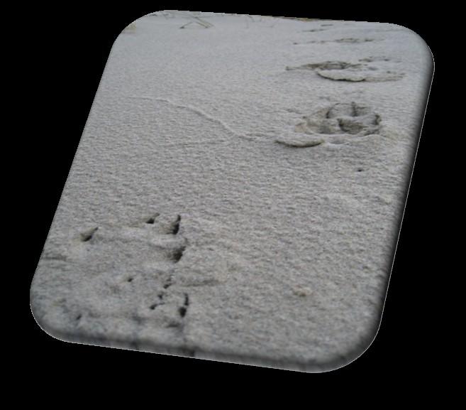
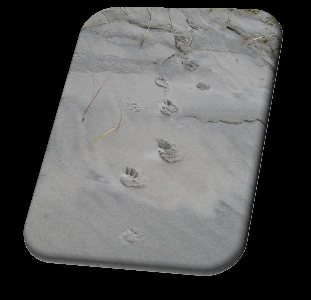

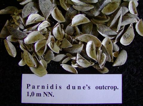
3 Tracks in Aeolian Sands cross-sectional view Nida foredune +H2O +HMC +frost Parnidis Dune??
4 Probable Undertrack in Cross-Section (Curonian Spit - dune slipfaces ~1,100 yr BP) slip dune migration fac e s

5 Probable Undertrack in Cross-Section (Curonian Spit - dune slipfaces ~1,100 yr BP)

 after")
6 Loading and extrusion of lagoonal muds extruded muds lagoon lagoon Lnagra Formation, (Upper Devonian) central Australia from Mountney (2006) after Collinson (1994)
 old")

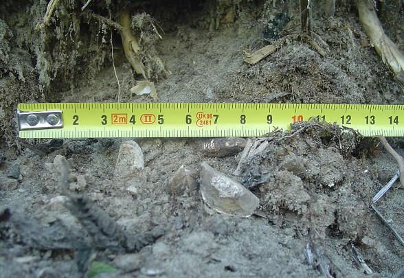
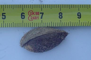
7 Mid-Holocene Fish Remains new exposure (2007/2008) old exposure 5,590-5,460 cal BP lagoon (Buynevich et al, 2010)


8 Dreissena polymorpha: a Black Sea native, but how recent a Baltic denizen? Aldona Damušytė Lithuanian Geological Survey Ilya Buynevich* Temple University, USA Albertas Bitinas Lithuanian Geological Survey Jonas Mažeika Institute of Geology and Geography, Lithuania Sergej Olenin Coastal Research & Planning Institute, Klaipėda University Rimantas Petrošius Institute of Geology and Geography, Lithuania (Buynevich et al, 2011)

 Canals (after Olenin et al.")
 1769 1775 1805")
9 Historic Migration Holocene Modern Orlova et al. (1998) after Starobogatov (1994) Canals (after Olenin et al., 1999; A. Karataev, and others) Oginskiy (Dnieper-Neman) Dnieper-Bug Dnieper-West Dvina


10 Examples of earlier species introduction ybp Mya arenaria Cardium edule Petersen et al. (1992)
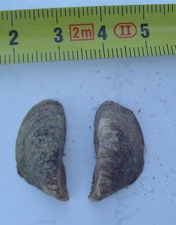
11 D. polymorpha uppermost horizons lagoon AMS age: 1,260±30 14C ybp


 modern samples >700 yr range 2250 2500")
12 Age distribution (14C ybp) of three fossil and bulk modern species C ybp 0 A.D map 14 Curonian Lagoon borehole No. 6 0 Vistula Spit outcrop Unio2 sp. 3 Viviparus sp. 4 Curonian Spit Curonian Spit outcrop 1 D. polymorpha Vistula Spit Little Ice Age Medieval Warm Period Curonian Lagoon (Lithuania) modern samples >700 yr range Vistula Lagoon (Kadyny, Poland) red - AMS dates (WHOI) green - bulk dates (Vilnius)
 bulk dates modern specimens - samples of three species from two lagoons Cons: - AMS")

13 Hypothesis 1: Abnormally Large Reservoir Effect Pros: - old ( ka) bulk dates modern specimens - samples of three species from two lagoons Cons: - AMS outcrop dates are younger than bulk modern - at least one near-modern AMS date - range of dates >700 years - similar dates for Vistula and Curonian Spits - admixture of old shells in original bulk samples?
 A.D.")

14 Hypothesis 2: Earlier Introduction (pre-1800) A.D map Natural proximity of Pontic - Baltic river headwaters 100 km

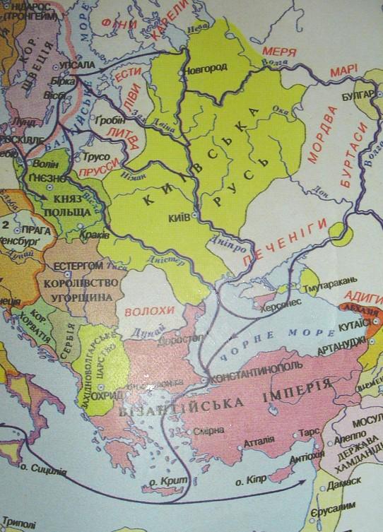
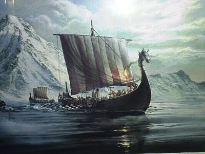
15 Viking Voyages Baltic-Black-Caspian Seas Ukrainian Naval Museum, Balaklava
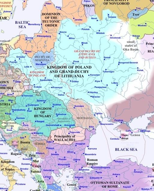
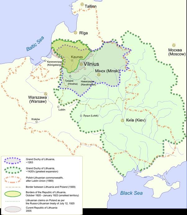
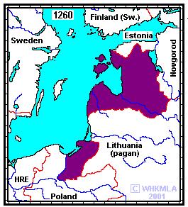
16 Lithuanian Territory in AD
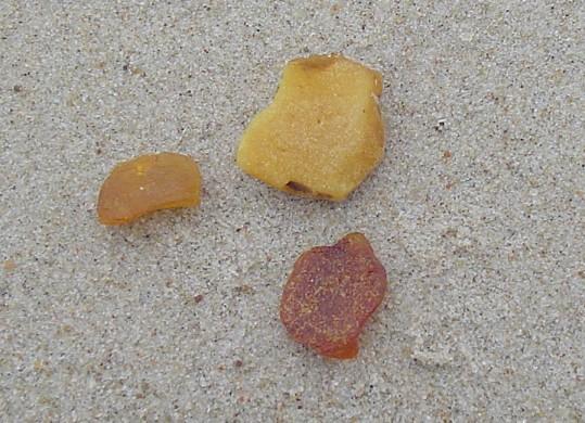

17 Geoarchaeology: Human-Landscape Interaction Early settlements (~4.5 ka) Vital strategic route Important postal road Fishing communities Amber extraction

")
 1 km North Advancing dunes(16-18th")
18 Sand Invasion (14-19th centuries) 14 settlements buried by migrating dunes Neolithic site (~4.5 ka BP) GPR transect (segment shown below) Buried settlements ( Modern towns relocation) Baltic Sea Curonian Lagoon Old Karvaičių II ( ) 1 km North Advancing dunes(16-18th century) Neringa


19 Point-Source Reflections buried objects buried objects control unit 200 MHz antenna λ buried object travel time


 885 5m Evangelical")
20 Buried Old Church Juodkrantė 886 fence pole 892 dune tree power station manhole 888 shed / 893 Profile Total Depth: m Old Church manhole buried object (60-80 cm depth) 885 5m Evangelical Lutheran Church North


21 Structures Buried by Aeolian Sands Karvaičių 0 tree root dune migration Curonian Spit ground surface hyperbolics 7m buried utilities water table buried structures? m 200 MHz
 - OSL dates suggest short phases of regional activity - HMCs: stratigraphic markers, paleo-wind intensity 2.")
22 Summary 1. Revised chronology of dune activity: - Three active phases during ka - Massive reactivation/bypassing during the Little Ice Age (LIA) - OSL dates suggest short phases of regional activity - HMCs: stratigraphic markers, paleo-wind intensity 2. Paleoecological Insights - Potential preservation of animal traces (role of HMCs) - Possible human-mediated transport of D. polymorpha - New lagoonal marl outcrops: sources of vertebrate remains 3. Geoarchaeology - Human-induced changes: pre-2.0 ka (?), ka (+LIA) - Point-source GPR reflections: mapping of buried sites

23 Ačiū Acknowledgments -Ocean & Climate Change Institute (WHOI) - National Geographic Society - Curonian Spit National Park - Anton Symonovich Thank you
 = DE")


24 Optically-Stimulated Luminescence (OSL) Dating Age = Paleodose / Dose rate OSL Signal intensity Age (ka) = DE (Gy)/DR (Gy/ka) Age range: 200,000 years to present Quartz / Feldspar grains Outcrops and trenches (above water table) Light-Proof Cores (below water table) Risø automated TL/OSL reader Sources: USGS; K. Keeper; University of Illinois-Chicago
Holocene dune reactivation along the northern Curonian Spit: geological, paleoecological, and archaeological implications
 Holocene dune reactivation along the northern Curonian Spit: geological, paleoecological, and archaeological implications Ilya Buynevich Temple University (USA) Collaborators: Albertas Bitinas Donatas
Rapid Coastal Dune Migration into Temperate and Equatorial Forests: Optical Chronology of Imaged Upper Slipface Strata
 Journal of Coastal Research SI 64 726-730 ICS2011 (Proceedings) Poland ISSN 0749-0208 Rapid Coastal Dune Migration into Temperate and Equatorial Forests: Optical Chronology of Imaged Upper Slipface Strata
THE PROGNOSIS OF CURONIAN SPIT DUNES EVOLUTION AND THEIR PROTECT STRATEGIES BECAUSE OF CLIMATE CHANGE
 THE PROGNOSIS OF CURONIAN SPIT DUNES EVOLUTION AND THEIR PROTECT STRATEGIES BECAUSE OF CLIMATE CHANGE A. Česnulevičius, A. Bautrėnas, R. Morkūnaitė, B. Karmaza Introduction The principal contribution studying
Diagnostic Characteristics of Extreme Events in South East Coast of India
 Diagnostic Characteristics of Extreme Events in South East Coast of India Rajesh R.Nair 1, Ilya Buynevich 2, Ron J Goble 3, P.Srinivasan 4, S.G.N.Murthy 4, C.S.Vijayalekshmi 1, Deshraj Trivedi 1 and S.C.Kandpal
CHAPTER 1 INTRODUCTION
 1 CHAPTER 1 INTRODUCTION 1.1 GENERAL Washover sandsheets are often found in low-lying coastal embayment s (Sedgwick and Davis 2003). Washover deposition of marine sand is usually attributed to storm activity
Reactivation of Coastal Dunes Documented by Subsurface Imaging of the Great Dune Ridge, Lithuania
 Journal of Coastal Research SI 50 226-230 ICS2007 (Proceedings) Australia ISSN 0749.0208 Reactivation of Coastal Dunes Documented by Subsurface Imaging of the Great Dune Ridge, Lithuania I. Buynevich,
APPLICATION OF GPR AND OSL IN INTERPRETATION OF DEPOSITIONAL HISTORY OF WESTERN PART OF FIRE ISLAND, NY By Vesna Kundic and Dan M.
 APPLICATION OF GPR AND OSL IN INTERPRETATION OF DEPOSITIONAL HISTORY OF WESTERN PART OF FIRE ISLAND, NY By Vesna Kundic and Dan M. Davis Coastal areas are important sedimentary environments as they are
Baltica 16 (2003) The Curonian Lagoon bottom sediments in the Lithuanian water area. Egidijus Trimonis, Saulius Gulbinskas, Modestas Kuzavinis
 The Curonian Lagoon bottom sediments in the Lithuanian water area. Egidijus Trimonis, Saulius Gulbinskas, Modestas Kuzavinis") Baltica www.geo.lt/baltica Baltica 16 (2003) 13-20 The Curonian Lagoon bottom sediments in the Lithuanian water area Distribution and composition of the Curonian Lagoon (Kurðiø Marios) bottom sediments
Baltica www.geo.lt/baltica Baltica 16 (2003) 13-20 The Curonian Lagoon bottom sediments in the Lithuanian water area Distribution and composition of the Curonian Lagoon (Kurðiø Marios) bottom sediments
Sea level changes and coastal evolution in the south-eastern Baltic Sea
 Sea level changes and coastal evolution in the south-eastern Baltic Sea L. Ž. Gelumbauskaitė, J. Šečkus Institute of Geology and Geography T. Ševčenkos str. 13, LT-03223 Vilnius, Lithuania The studying
Question #1: What are some ways that you think the climate may have changed in the area where you live over the past million years?
 Reading 5.2 Environmental Change Think about the area where you live. You may see changes in the landscape in that area over a year. Some of those changes are weather related. Others are due to how the
ON THE EVOLUTION OF A HOLOCENE BARRIER COAST
 ON THE EVOLUTION OF A HOLOCENE BARRIER COAST Response to sea-level change and sediment supply DANCORE Seminar 2014 COADAPT - Danish Coasts and Climate Adaptation Flooding Risk and Coastal Protection Mikkel
Climate Change. April 21, 2009
 Climate Change Chapter 16 April 21, 2009 Reconstructing Past Climates Techniques Glacial landscapes (fossils) CLIMAP (ocean sediment) Ice cores (layering of precipitation) p Otoliths (CaCO 3 in fish sensory
since 1961 BALTICA Volume 28 Number 1 June 2015: doi: /baltica
 since 1961 BALTICA Volume 28 Number 1 June 2015: 41 50 doi: 10.5200/baltica.2015.28.05 Holocene organic-rich sediments within the Curonian Spit coast, the south-eastern Baltic Sea Alexander Sergeev, Vadim
PALEONTOLOGY - the study of the history of life as reflected in the fossil record
 Paleontology PALEONTOLOGY - the study of the history of life as reflected in the fossil record FOSSIL - remains or traces of organisms that lived in the geologic past and are preserved in the crust of
The Geology of Sebago Lake State Park
 Maine Geologic Facts and Localities September, 2002 43 55 17.46 N, 70 34 13.07 W Text by Robert Johnston, Department of Agriculture, Conservation & Forestry 1 Map by Robert Johnston Introduction Sebago
Reconstruction of the Dead (Grey) Dune evolution along the Curonian Spit, Southeastern Baltic
 Dune evolution along the Curonian Spit, Southeastern Baltic") 49 Bulletin of the Geological Society of Finland, Vol. 85, 2013, pp 49 60 Reconstruction of the Dead (Grey) Dune evolution along the Curonian Spit, Southeastern Baltic NIKITA DOBROTIN 1)*, ALBERTAS BITINAS
49 Bulletin of the Geological Society of Finland, Vol. 85, 2013, pp 49 60 Reconstruction of the Dead (Grey) Dune evolution along the Curonian Spit, Southeastern Baltic NIKITA DOBROTIN 1)*, ALBERTAS BITINAS
FORMATION OF GROUNDWATER IN SEDIMENTARY BASINS: TRADITIONAL AND ALTERNATIVE MODELS
 FORMATION OF GROUNDWATER IN SEDIMENTARY BASINS: TRADITIONAL AND ALTERNATIVE MODELS Albertas Bitinas Klaipėda University, Coastal Research and Planning Institute, H. Manto St. 84, Klaipėda, Lithuania, albertas.bitinas@corpi.ku.lt
Depositional Environments. Depositional Environments
 Depositional Environments Geographic area in which sediment is deposited Characterized by a combination of geological process & environmental conditions Depositional Environments Geological processes:
Application of remote sensing technologies for engineering for onshore pipelines in active dune fields
 Application of remote sensing technologies for engineering for onshore pipelines in active dune fields Jason Manning, Arup (jason.manning@arup.com) Dr Matthew Free, Arup (matthew.free@arup.com) Dr Charlie
SCIENTIFIC DATING IN ARCHAEOLOGY
 SCIENTIFIC DATING IN ARCHAEOLOGY Tsuneto Nagatomo 1. AGE DETERMINATION IN ARCHAEOLOGY Relative Age: stratigraphy, typology Absolute Chronology: historical data Age Determination by (natural) Scientific
GEOLOGY MEDIA SUITE Chapter 5
 UNDERSTANDING EARTH, SIXTH EDITION GROTZINGER JORDAN GEOLOGY MEDIA SUITE Chapter 5 Sedimentation Rocks Formed by Surface Processes 2010 W.H. Freeman and Company Mineralogy of sandstones Key Figure 5.12
Aeolian Environments and Controls on Sedimentation. Alex Bryk, Ron Cash, Jacob Wikle, Rebecca Alberts
 Aeolian Environments and Controls on Sedimentation Alex Bryk, Ron Cash, Jacob Wikle, Rebecca Alberts Aeolian dunes develop in desert systems where there is an abundance of sand-grade material available
Anomalous fading: a reply to the comment by Huntley on "Isochron measurements of naturally irradiated K-feldspar grains"
 University of Wollongong Research Online Faculty of Science, Medicine and Health - Papers Faculty of Science, Medicine and Health 2011 Anomalous fading: a reply to the comment by Huntley on "Isochron measurements
Moosehead Lake and the Tale of Two Rivers
 Maine Geologic Facts and Localities June, 2005 45 o 53 5.09 N, 69 o 42 14.54 W Text by Kelley, A.R.; Kelley, J.T.; Belknap, D.F.; and Gontz, A.M. Department of Earth Sciences, University of Maine, Orono,
Studying The Past. Why Do We Study Fossils Found in Rocks?
 I. What is a Fossil? Studying The Past A. Definition: The evidence or remains of once-living plants or animals Why Do We Study Fossils Found in Rocks? QQ#1 what is a fossil? Why are they important? A.
Determining the History of Dune du Pilat, France: An Application of Ground Penetrating Radar and Sedimentology Techniques
 Determining the History of Dune du Pilat, France: An Application of Ground Penetrating Radar and Sedimentology Techniques By Sarah Betancourt, Sanna Lee, Nicholas Ritter, Emmanuel Teferi, and Joe Zhang
GEOLOGICAL AGE OF ROCKS. Absolute geological age
 GEOLOGICAL AGE OF ROCKS Absolute geological age The pioneer of nuclear physics discovered at the turn of centuries that atoms of certain elements, the radioactive ones, spontaneously disintegrate to form
GSW spring field trip. Geomorphic Evolution of Great Falls and Mather Gorge
 GSW spring field trip Geomorphic Evolution of Great Falls and Mather Gorge Led by E-an Zen, University of Maryland Saturday, May 17, 2003 9 a.m. to 12:30 p.m. Photo by Priestley Toulmin The focus of this
2.2.7 Backbarrier flats
 FIGURE 24. VERTICAL PHOTOGRAPH SHOWING THE DEVELOPMENT OF SMALL PARABOLIC DUNES FROM BLOWOUTS IN A LARGE RELICT FOREDUNE NORTHWEST OF HUNTER'S CREEK. PHOTOGRAPH COURTESY OF CAR'T'ER HOLT HARVEY FORESTS
Environment Bay of Plenty Ohope Beach system
 Environment Bay of Plenty 7 5. Ohope Beach system Environmental Publication 27/ NERMN Beach Profile Monitoring Environment Bay of Plenty 5..1 Ohope Spit (CCS 9) Discussion The site is located 2m to the
geologic age of Earth - about 4.6 billion years
 Geologic Time Geologic Time geologic age of Earth - about 4.6 billion years Geologic Time very difficult to appreciate from our human perspective necessary to understand history of Earth two basic ways
Earth s Changing Surface Chapter 4
 Name Hour Due Date Earth s Changing Surface Chapter (You do not need your book) Page 1 Fossils Summary Page 2 Traces of Tracks Page 3 Finding the Relative Age of Rocks Summary. Page - Finding the Relative
The Nature of Sedimentary Rocks
 The Nature of Sedimentary Rocks Sedimentary rocks are composed of: Fragments of other rocks Chemical precipitates Organic matter or biochemically produced materials The Nature of Sedimentary Rocks Sedimentary
ARCHAEOLOGICAL METHOD FEHMARN STYLE
 ARCHAEOLOGICAL METHOD FEHMARN STYLE Digital archaeology By: Nadja M. K. Mortensen, Prehistoric Archaeologist, Responsible for GIS Overview of the survey area Digital measuring and registration are an important
Summary Report. 7-8 November, 2013 Sports Complex of the Central Sports Club of the Army, Severnyi mol 7 Baltiysk, Kaliningrad Oblast Region, Russia
 RU LT Transnational stakeholders meeting on the concept for maritime spatial planning in the Lithuanian Sea and its potential impacts on sea use in Russia 7-8 November, 2013 Sports Complex of the Central
BALTICA Volume 23 Number 2 December 2010 :
 BALTICA Volume 23 Number 2 December 2010 : 109-116 Palaeo Nemunas delta history during the Holocene time Leonora Živilė Gelumbauskaitė Gelumbauskaitė, L. Ž. 2010. Palaeo Nemunas delta history during the
MOR SEAWAY TEACHERS. A CHANGING LANDSCAPE Activity Overview BIG IDEA
 MOR SEAWAY 03 Activity Overview BIG IDEA The Earth and its landscapes change over time. Scientists use the fossil record to understand the Earth s environments and climates millions of years ago. OBJECTIVE
Unit 2 Lesson 1 Geologic Change over Time. Copyright Houghton Mifflin Harcourt Publishing Company
 Been There, Done That What is the principle of uniformitarianism? The principle of uniformitarianism states that geologic processes that happened in the past can be explained by current geologic processes.
Rare earth elements of Holocene sediments in the South- Eastern Baltic Region (Nida VI borehole, Lithuania)
") GEOLOGIJA. 2013. Vol. 55. No. 1(81). P. 1 7 Lietuvos mokslų akademija, 2013 Rare earth elements of Holocene sediments in the South- Eastern Baltic Region (Nida VI borehole, Lithuania) Donatas Kaminskas,
GEOLOGIJA. 2013. Vol. 55. No. 1(81). P. 1 7 Lietuvos mokslų akademija, 2013 Rare earth elements of Holocene sediments in the South- Eastern Baltic Region (Nida VI borehole, Lithuania) Donatas Kaminskas,
PSI analysis of ground deformations along the south-western coast of the Gulf of Gdansk (Poland)
") FRINGE 2009 WORKSHOP, Advances in the Science and Applications of SAR Interferometry 30 November 4 December 2009 ESA-ESRIN Frascati, Italy PSI analysis of ground deformations along the south-western coast
FRINGE 2009 WORKSHOP, Advances in the Science and Applications of SAR Interferometry 30 November 4 December 2009 ESA-ESRIN Frascati, Italy PSI analysis of ground deformations along the south-western coast
Holocene Lower Mississippi River Avulsions: Autogenic Versus Allogenic Forcing*
 Holocene Lower Mississippi River Avulsions: Autogenic Versus Allogenic Forcing* Eric Prokocki 1,2 Search and Discovery Article #50330 (2010) Posted October 14, 2010 *Adapted from oral presentation at AAPG
Content Area: Social Studies Standard: 1. History Prepared Graduates: Develop an understanding of how people view, construct, and interpret history
 Standard: 1. History Develop an understanding of how people view, construct, and interpret history 1. Organize and sequence events to understand the concepts of chronology and cause and effect in the history
EARTH SURFACE PROCESSES AND SEDIMENTATION!
 Sed and Strat EARTH SURFACE PROCESSES AND SEDIMENTATION! 2/27 Lecture 7- Exposure: Weathering and the Sediment Factory 3/04 Lecture 8 - Rivers and Landscapes 3/06 Lecture 9 - Waves (not Tides) 3/11 Lecture
NAME: GEL 109 Final Study Guide - Winter 2008 Questions 6-24 WILL be on the final exactly as written here; this is 60% of the test.
 GEL 109 Final Study Guide - Winter 2008 Questions 6-24 WILL be on the final exactly as written here; this is 60% of the test. 1. Sketch a map view of three types of deltas showing the differences in river,
Intensity of geodynamic processes in the Lithuanian part of the Curonian Spit
 https://doi.org/10.5194/esd-8-419-2017 Author(s) 2017. This work is distributed under the Creative Commons Attribution 3.0 License. Intensity of geodynamic processes in the Lithuanian part of the Curonian
GEOCHRONOLOGICAL AND SEDIMENTOLOGICAL INTERPRETATION OF INTERGLACIAL AQUATIC SEDIMENTS BASED ON TL DATING
 GEOCHRONOMETRIA (2), pp 7-83 DOI.2478/v3--3-7 Available online at versita.metapress.com and www.geochronometria.pl GEOCHRONOLOGICAL AND SEDIMENTOLOGICAL INTERPRETATION OF INTERGLACIAL AQUATIC SEDIMENTS
Section 1: How Did Life Begin? Chapter 19: History of Life on Earth. Section 2: The Age of Earth
 Chapter 19: History of Life on Earth Section 1: How Did Life Begin? I. The Basic Chemicals of Life A. 1920s B. Earth s early oceans contained large amounts of organic molecules C. Molecules formed spontaneously
Introduction to Quaternary Geology (MA-Modul 3223) Prof. C. Breitkreuz, SS2012, TU Freiberg
 Prof. C. Breitkreuz, SS2012, TU Freiberg") Introduction to Quaternary Geology (MA-Modul 3223) Prof. C. Breitkreuz, SS2012, TU Freiberg 1. Introduction: - Relevance, and relations to other fields of geoscience - Lower stratigraphic boundary and
Introduction to Quaternary Geology (MA-Modul 3223) Prof. C. Breitkreuz, SS2012, TU Freiberg 1. Introduction: - Relevance, and relations to other fields of geoscience - Lower stratigraphic boundary and
POST-NIPISSING ORIGIN OF A BACKDUNE COMPLEX ALONG THE SOUTHEASTERN SHORE OF LAKE MICHIGAN
 POST-NIPISSING ORIGIN OF A BACKDUNE COMPLEX ALONG THE SOUTHEASTERN SHORE OF LAKE MICHIGAN Edward C. Hansen Department of Geological and Environmental Sciences Hope College Holland, Michigan 49422 Alan
Optical dating sediments from coastal British Columbia:
 Optical dating sediments from coastal British Columbia: Successes, challenges and plans for the future Christina M. Neudorf 1, 2, Olav B. Lian 1, Libby C.M. Biln 2, 3, Jordan K. Bryce 2, 4, Jordan B.R.
Jasper Beach, Machiasport, Maine
 Maine Geologic Facts and Localities June, 2000 Jasper Beach, Machiasport, Maine 44 o 38 30.28 N, 67 o 22 31.96 W Text by Joesph T. Kelley, Department of Agriculture, Conservation & Forestry 1 Map by USGS
Clues to Earth s Past. Fossils and Geologic Time
 Clues to Earth s Past Fossils and Geologic Time Fossils A. Paleontologists study fossils and reconstruct the appearance of animals. Fossils B. Fossils remains, imprints, or traces of prehistoric organisms
Weather - the physiochemical state of the atmosphere during any short period of time.
 Weather - the physiochemical state of the atmosphere during any short period of time. Climate - the average physiochemical state of the atmosphere over the course of the year. Surface Ocean Temperatures
Objectives: Define Relative Age, Absolute Age
 S6E5. Students will investigate the scientific view of how the earth s surface is formed. c. Classify rocks by their process of formation. g. Describe how fossils show evidence of the changing surface
The Influence of Fog on the Propagation of the Electromagnetic Waves under Lithuanian Climate Conditions
 PIERS ONLINE, VOL. 5, NO. 6, 2009 576 The Influence of Fog on the Propagation of the Electromagnetic Waves under Lithuanian Climate Conditions S. Tamosiunas 1, 2, M. Tamosiunaite 1, 2, M. Zilinskas 1,
Name: Period: Date: ID: A. Circle the choice that best completes the statement or answers the question and write the letter on the blank.
 Name: Period: _ Date: _ ID: A Unit 7 Practice Circle the choice that best completes the statement or answers the question and write the letter on the blank. 1. What term describes the movement of rock
Studying The Past. II. Why Do We Study Fossils Found in Rocks?
 Studying The Past I. What is a Fossil? A. Definition: The evidence or remains of once-living plants or animals II. Why Do We Study Fossils Found in Rocks? A. To provide evidence of the past existence of
An Arctic Perspective on Climate Change
 An Arctic Perspective on Climate Change 23 Oct 2012 Gifford Miller (and many others) University of Colorado Boulder The Earth is warming How do we know? Temperature Anomaly ( C) It s a fact Global Land
Jarmila Krzymińska. Contents. Introduction
 The distribution of Cerastoderma glaucum (Poiret), Macoma balthica (Linnaeus), Mya arenaria (Linnaeus) and Mytilus edulis (Linnaeus), in Holocene bottom sediments of the southern Baltic Sea Jarmila Krzymińska
Recent Climate History - The Instrumental Era.
 2002 Recent Climate History - The Instrumental Era. Figure 1. Reconstructed surface temperature record. Strong warming in the first and late part of the century. El Ninos and major volcanic eruptions are
Milford Public Schools Curriculum
 Milford Public Schools Curriculum Department: Social Studies Grade 3 Course Name: Communities Course Description In third grade, students will engage in a yearlong study of communities and specifically
UNIT 4 SEDIMENTARY ROCKS
 UNIT 4 SEDIMENTARY ROCKS WHAT ARE SEDIMENTS Sediments are loose Earth materials (unconsolidated materials) such as sand which are transported by the action of water, wind, glacial ice and gravity. These
Outline 24: The Holocene Record
 Outline 24: The Holocene Record Climate Change in the Late Cenozoic New York Harbor in an ice-free world (= Eocene sea level) Kenneth Miller, Rutgers University An Ice-Free World: eastern U.S. shoreline
Fossil Clues Teacher s Notes
 Fossils are the remains of living things which have been changed into rock. The father of modern geology, James Hutton, said that we can interpret the nature of creatures from the past and the environment
PHASE 1 STUDIES UPDATE EROSION WORKING GROUP
 PHASE 1 STUDIES UPDATE EROSION WORKING GROUP Presented By MICHAEL WOLFF, PG Erosion Study Area Manager West Valley Demonstration Project Quarterly Public Meeting February 24, 2016 OUTLINE Study 1 Terrain
THE CONTACT BETWEEN THE PRECAMBRIAN SHIELD AND THE PHANEROZOIC SEDIMENTARY ROCKS Lab Report (Lab #2) Submitted to: Professor Simone Dumas
 Submitted to: Professor Simone Dumas") THE CONTACT BETWEEN THE PRECAMBRIAN SHIELD AND THE PHANEROZOIC SEDIMENTARY ROCKS Lab Report (Lab #2) Submitted to: Professor Simone Dumas For the course Introduction to Earth Materials (GE01115) By: Gabriella
THE CONTACT BETWEEN THE PRECAMBRIAN SHIELD AND THE PHANEROZOIC SEDIMENTARY ROCKS Lab Report (Lab #2) Submitted to: Professor Simone Dumas For the course Introduction to Earth Materials (GE01115) By: Gabriella
3. The diagram below shows how scientists think some of Earth's continents were joined together in the geologic past.
 1. The map below shows the present-day locations of South America and Africa. Remains of Mesosaurus, an extinct freshwater reptile, have been found in similarly aged bedrock formed from lake sediments
Late Pleistocene Mono Basin Beach Berms, California: Preliminary OSL Ages
 Late Pleistocene Mono Basin Beach Berms, California: Preliminary OSL Ages Larry N. Smith: Geological Engineering, Montana Tech Guleed A.H. Ali, Sidney Hemming: Department of Earth and Environmental Sciences
NOTES: The Fossil Record and Geologic Time
 NOTES: The Fossil Record and Geologic Time Vocabulary: Paleontologist Fossil record extinct Relative dating Absolute dating Geologic time scale Objectives: What are fossils? How are they made? How do scientists
ESC102. Sedimentary Rocks. Our keys to the past. Monday, February 11, 13
 ESC102 Sedimentary Rocks Our keys to the past Sedimentary Rocks Sedimentary rocks are rocks that form through the accumulation of sediment and the process of lithification. Lithification occurs after deposition
Lecture Outline Friday Feb. 21 Wednesday Feb. 28, 2018
 Lecture Outline Friday Feb. 21 Wednesday Feb. 28, 2018 Questions? Key Points for today What are the 5 relative age dating principles and how do you apply the principles to determine a geologic history
Geology (Mellow) Hike, Santa Lucia Memorial Park February 16, I. Overview of Santa Lucia Range geology and tectonic history
 Hike, Santa Lucia Memorial Park February 16, I. Overview of Santa Lucia Range geology and tectonic history") Geology (Mellow) Hike, Santa Lucia Memorial Park February 16, 2015 I. Overview of Santa Lucia Range geology and tectonic history A. Basement Rocks 1. Salinian Block Rocks Sierra Nevada Type, continental
Geology (Mellow) Hike, Santa Lucia Memorial Park February 16, 2015 I. Overview of Santa Lucia Range geology and tectonic history A. Basement Rocks 1. Salinian Block Rocks Sierra Nevada Type, continental
Investigating snow accumulation variability on the Antarctic Peninsula using Ground Penetrating Radar. - A tool for interpreting ice core records
 Investigating snow accumulation variability on the Antarctic Peninsula using Ground - A tool for interpreting ice core records Elizabeth R. Thomas June 2008 Scientific Report in support of Loan 824 Identifying
Looking at Fossils. Fossilized Organisms. Fossils in Rocks. Fossils in Amber
 1 Looking at Fossils Key Concept Fossils provide evidence of how life and environmental conditions have changed. What You Will Learn Evidence of past life is preserved as fossils in sedimentary rock and
A Trip Through Geologic Time
 Date Class _ A Trip Through Geologic Time Chapter Test A Multiple Choice Write the letter of the correct answer on the line at the left. 1. Late in the Paleozoic Era, the supercontinent Pangaea formed.
Sedimentary Geology. Strat and Sed, Ch. 1 1
 Sedimentary Geology Strat and Sed, Ch. 1 1 Sedimentology vs. Stratigraphy Sedimentology is the study of the origin and classification of sediments and sedimentary rocks Mostly the physical and chemical
History of Cartography,
 Maps History of Cartography, the art and science of making maps ~2300 BC ~600 BC Early oldest known maps: Babylonian clay tablets. Greek and Roman Ptolemy s (about AD 85-165) "world map" depicted the Old
Geologic Time. The Cenozoic Era. 7. Mammals evolved after dinosaurs became extinct.
 Geologic Time The Cenozoic Era Key Concepts What major geologic events occurred during the Cenozoic era? What does fossil evidence reveal about the Cenozoic era? What do you think? Read the two statements
The Overall Objectives of Proposed Study
 Eric Prokocki is currently working on a Ph.D. degree at The University of Illinois. His advisor is Dr. Gary Proctor. His research project is related to Holocene evolution and avulsion dynamics of the lower
Active Coastal Processes in the Lubec Embayment
 The Lubec Embayment Maine Geologic Facts and Localities August, 1998 Active Coastal Processes in the Lubec Embayment 44 49 50.51 N, 66 59 34.16 W Text by Joseph T. Kelley, Department of Agriculture, Conservation
Sea-level Rise on Cape Cod: How Vulnerable Are We? Rob Thieler U.S. Geological Survey Woods Hole, MA
 Sea-level Rise on Cape Cod: How Vulnerable Are We? Rob Thieler U.S. Geological Survey Woods Hole, MA Outline Sea-level and coastal processes Past sea-level change Predictions for the future Coastal responses
Geologic Time. What is Age? Absolute Age The number of years since the rock formed. (150 million years old, 10 thousand years old.
 Geologic Time There are 2 kinds: What is Age? Absolute Age The number of years since the rock formed. (150 million years old, 10 thousand years old.) Relative Age The age compared to the ages of other
World History: Grade 9 Lesson 3: Unit 0.2 The Personality of Earth s Surface
 World History: Grade 9 Lesson 3: Unit 0.2 The Personality of Earth s Surface Unit 0.2 Lesson 3: The Personality of Earth s Surface M.T. Donkin Unit Objectives: 1.) Differentiate among various flat world
Section 7. Reading the Geologic History of Your Community. What Do You See? Think About It. Investigate. Learning Outcomes
 Chapter 3 Minerals, Rocks, and Structures Section 7 Reading the Geologic History of Your Community What Do You See? Learning Outcomes In this section, you will Goals Text Learning Outcomes In this section,
Last Time. Submarine Canyons and Fans. Turbidites. MAS 603: Geological Oceanography. Lecture 16: Greenhouse vs. Icehouse Earths
 UNIVERSITY OF SOUTH ALABAMA Last Time MAS 603: Geological Oceanography Lecture 16: Greenhouse vs. Icehouse Earths Submarine Fans Definition and morphology Transport mechanisms (density currents) Submarine
Your web browser (Safari 7) is out of date. For more security, comfort and the best experience on this site: Update your browser Ignore
 is out of date. For more security, comfort and the best experience on this site: Update your browser Ignore") Your web browser (Safari 7) is out of date. For more security, comfort and the best experience on this site: Update your browser Ignore ISTHMU S tombolo For the complete encyclopedic entry with media resources,
Your web browser (Safari 7) is out of date. For more security, comfort and the best experience on this site: Update your browser Ignore ISTHMU S tombolo For the complete encyclopedic entry with media resources,
Use of Ground Penetrating Radar to identify the presence and orientation of Graves in St. Brigitts Cemetery, Bergen New York
 The College at Brockport: State University of New York Digital Commons @Brockport Geotechnical Survey Reports Department of the Earth Sciences 2013 Use of Ground Penetrating Radar to identify the presence
The Niagara Escarpment extends from western New York, through the GTA all the way up to Manitoulin Island and into Michigan and Wisconsin.
 is southern Ontario s most prominent topographic feature, extending more than 500 kilometres from western New York, through Niagara Falls and the western part of the Greater Toronto Area (GTA), and north
Paleo Lab #4 - Sedimentary Environments
 Paleo Lab #4 - Sedimentary Environments page - 1. CHARACTERISTICS OF SEDIMENT Grain size and grain shape: The sizes and shapes of sedimentary particles (grains) are modified considerably during their transportation
Changing Marine Access in the Arctic Ocean: The Arctic Climate Impact Assessment Panama Canal Authority 11 January 2005
 Changing Marine Access in the Arctic Ocean: The Arctic Climate Impact Assessment Panama Canal Authority 11 January 2005 Lawson Brigham Deputy Director, U.S. Arctic Research Commission ACIA Contributing
THE SCIENCE OF MAPS. ATL Skill: Critical thinking - Use models and simulations to explore complex systems and issues
 THE SCIENCE OF MAPS 8.9C interpret topographic maps and satellite views to identify land and erosional features and predict how these features may be reshaped by weathering ATL Skill: Critical thinking
Global climate change
 Global climate change What is climate change? This winter was really cold! Temp difference ( C): Jan 2004 vs. Jan 2002-2003 Make your own maps at: http://www.giss.nasa.gov/data/update/gistemp/maps/ 1 What
Pleistocene Terrace Deposits of the Crystal Geyser Area e. r G. P5 5o. M1/Qal. M3 3y M4 M5 M5. 5o M6y P6. M1/Qal
 0 M6 C O N T O UR IN T E R V A L 4 0 F E E T NO R T H A ME R IC A N V E R T IC A L D A T UM O F 1 9 8 8 500 METERS KILOMETERS 0.5 S C A L E 1 : 1 2,0 0 0 r M1/Qal USU-780 P6 1000 1 5o M6y P6 y M4 M5 M5
Mudanças paleo-hidrológicas, cronologia de eventos e dinâmica sedimentar no Quaternário da Bacia do Pantanal
 UNIVERSIDADE ESTADUAL PAULISTA INSTITUTO DE GEOCIÊNCIAS E CIÊNCIAS EXATAS CAMPUS DE RIO CLARO FAPESP 2014/06889-2 Mudanças paleo-hidrológicas, cronologia de eventos e dinâmica sedimentar no Quaternário
Continental shelf records of climate change
 Continental shelf records of climate change Wyss W.-S. Yim Guy Carpenter Asia-Pacific Climate Impact Centre, City University of Hong Kong / Department of Earth Sciences, The University of Hong Kong Hong
A journey through the earth history of Australia s Coastal Wilderness Part 3 The backdrop - a 70 million year old plain
 A journey through the earth history of Australia s Coastal Wilderness Part 3 The backdrop - a 70 million year old plain Monaro Plain 3. The Cretaceous Plain The western horizon behind Moruya is dominated
Lab 7: Sedimentary Structures
 Name: Lab 7: Sedimentary Structures Sedimentary rocks account for a negligibly small fraction of Earth s mass, yet they are commonly encountered because the processes that form them are ubiquitous in the
Jan. 15, 2013 Historical Background
 Jan. 15, 2013 Historical Background Seventeenth Century Knowledge of Fossils 1) They varied from objects having an obvious resemblance to organisms-shells of mollusks and leaves of plants-through a complete
Long-Term Patterns of Coastal Response to Changing Land Use and Climate: Examples from the Atlantic and Gulf Coastal Plains
 Long-Term Patterns of Coastal Response to Changing Land Use and Climate: Examples from the Atlantic and Gulf Coastal Plains Debra Willard, Christopher Bernhardt, and Miriam Jones U.S. Geological Survey,
CLIMATE CHANGE, CATASTROPHE AND THE TIDES OF HISTORY. 1. CLIMATE THE LONG VIEW.
 LL Innis / 3ALB 2018 CLIMATE CHANGE, CATASTROPHE AND THE TIDES OF HISTORY. 1. CLIMATE THE LONG VIEW. Climate has controlled our evolution, our spread around the globe, and our social, political, economic