GIS-based multivariate statistical analysis for landslide susceptibility zoning: a first validation on different areas of Liguria region (Italy)
|
|
|
- Heather Ross
- 5 years ago
- Views:
Transcription


1 FOSS4G-Europe 2015 July 14th 17th, Como GIS-based multivariate statistical analysis for landslide susceptibility zoning: a first validation on different areas of Liguria region (Italy) R. Marzocchi, A. Rovegno, B. Federici, R. Bovolenta & R. Berardi DICCA Polytechnic School University of Genoa Italy

: heuristic analysis based on geological and geomorphological criteria and local")

2 Introduction 6.9% of the territory is catalogued as landslide by the IFFI national inventory of landslide (ISPRA, 2013) Several approaches to assess landslide hazard (Fell et al., 2008): heuristic analysis based on geological and geomorphological criteria and local observations collected by an expert statistical methods usually correlate an inventory of landslides occurred in the past with factors which are supposed to be responsible of slope failure (Cascini, 2008) process-based methods and numerical analysis local analysis
3 Introduction The type of landslides involved in this study are slides and flows (according to the UNESCO WP/WLI, 1993) associated to intense meteorological events affecting limited thickness of the loose soil local contributing factors related to humans (eg. road cuts) not only emergency management but also prevention Land use planning supported by landslide susceptibility zoning

4 Introduction The aim Landslide susceptibility zoning on wide area through GIS-based multivariate statistical analysis To express objectively the landslide susceptibility in accordance with many factors The present research Criticality analysis of the zoning procedure to develop a guideline for the landslide susceptibility zoning, as an instrument to non-gis and non-statistical expert users for the choice of factors to be considered. Software GRASS GIS 7.0
5 Introduction Overview Predisposing factors to landslide Logistic multiple regression Critical analysis Conclusions

6 Predisposing factors to landslide Lithology stratigraphy Distance from tectonic alignments Soil type Soil depth slope Morphological parameters aspect Elevation above sea level Distance from the drainage network accumulation Land use vegetation Distance from road network Mean monthly rain Literature analysis geological Morphological anthropogenic climatic Climatic aggressivity FFAO 1. Slope 2. Land use 3. Lithology 4. Aspect proven factors of instability Natali et al. (2010) x x x 5. Accumulation 6. Elevation above sea level Pradhan & Lee (2010) x x x x x x x x x 7. Distance from road network Pauditš & Bednárik (2002) x x x 8. Climatic aggressivity FFAO Lee (2007) (x) x x x x x x x Dahal et al. (2008) Cencetti et al. (2010) Dai & Lee (2002) Ayalew & Yamagishi (2005) x x x x x x x x x x x x x x x x (x) x x (x) x x x x x x x x Raster maps (20x20 m) reclassified for the area that you want to submit a zoning
7 Predisposing factors to landslide Bivariate analysis to reduce number of classes Land use classification 1 Other 2 Buildings 3 Agricultural areas 4 Wood 5 Sparse vegetation 6 Bare soil/rock to have monotonic (increasing or decreasing) trend of variables P evento x = P evento x P x
 c) aspect d) slope e) lithology f) distance from road g)")
8 Predisposing factors to landslide Bivariate analysis a) F FAO b) Log(accumulation) c) aspect d) slope e) lithology f) distance from road g) Elevation h) land cover
9 Logistic multiple regression Logistic multiple regression Generalized linear model (GLM), appropriate for dichotomous data (0 = absence of landslide, 1 = presence of landslide) P evento X = e Z Z = logit evento = β 0 + β 1 X β p X p
10 Logistic multiple regression Logistic multiple regression 1st phase: Calibration P evento X = e Z inventory of landslide (IFFI) associating: P=1 if landslide area P=0 if NOT landslide area Z = logit evento = β 0 + β 1 X β p X p chosen factors Estimation of regressions coefficients
11 Logistic multiple regression Logistic multiple regression 2nd phase: Application P evento X = e Z Calculated landslide susceptibility Z = logit evento = β 0 + β 1 X β p X p chosen factors Estimated regressions coefficients
12 Critical analysis Critical points of the procedure Classification of chosen factors bivariate analysis Selection of the indipendent variables of the regression model (factors) Choice of the proper area to calibrate the coefficient of the regression model Definition of a criterion of classification of the susceptibility values
13 Critical analysis Test area Liguria Region (Italy) and its 4 Provinces
14 Critical analysis 2 (pendenza e uso suolo) 3 (+litologia) 4 (+accumulazione) 5 (+esposizione) 6 (+AC) 7 (+classi quota) 8 (+distanza strade) Selection of the indipendent factors Defined the calibration area... AIC index (Akaike s Information Criteria) AIC If the adding of a variable has a positive effect on the model, the values of AIC have to decrease n regressori
15 Critical analysis The proper area to calibrate Defined the factors... R 2 correlation coefficient indication of the influence factor of the j-th factor on the susceptibility R 2 0,0014 0,0012 0,0010 0,0008 pendenza Slope Land use Lithology Accumulation Aspect Elevation Distance to roads uso suolo litologia accumulazione esposizione quota distanza strade aggress.climatica FFAO 0,0006 0,0004 0,0002 0,0000 Regione Liguria provincia Imperia provincia Savona provincia Genova provincia La Spezia

16 Critical analysis coeff. regressione Factors vs calibration area Regression coefficients bj reliability of the factors Slope land use lithology accumul aspect elevation dist road FFAO pendenza uso suolo litologia accumulazione esposizione quota distanza strade aggress.climatica 0,13 0,08 0,03-0,02-0,07-0,12-0,17-0,22 Reliable factors slope Land use accumulation Distance from road Regione Liguria provincia Imperia provincia Savona provincia Genova provincia La Spezia -0,27


17 Critical analysis Factors vs calibration area Lithology map Importance of spatial variability of factors Low Medium high bassa media alta FFAO map

18 Critical analysis Factors vs calibration area R 2 correlation coefficient indication of the influence factor of the j-th factor on the susceptibility R 2 0,0070 0,0060 0,0050 Piemonte 0,0040 0,0030 Liguria 0,0020 0,0010 0,0000 dist.da aggress. pendenza Slope land uso suolo use lithology litologia dist road accumul. aspect esposiz. elevation quota FFAO strade climatica Piemonte 0, , , , , , , , Liguria 0, , , , , , , ,000005
 5.4 e-09 Classification in 3 susceptibility level low moderate high")
19 Critical analysis Classification of the susceptibility values Estimated values of susceptibility Relative results 4.3 e-08 Very small values (order of ) 5.4 e-09 Classification in 3 susceptibility level low moderate high


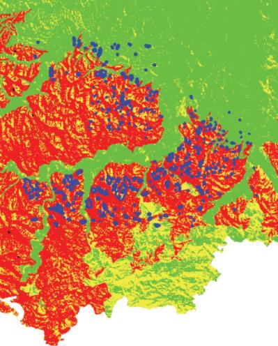

20 Critical analysis Results and validation Low Moderate High signs of instability incipient sliding
21 Critical analysis Results and validation Low Moderate High


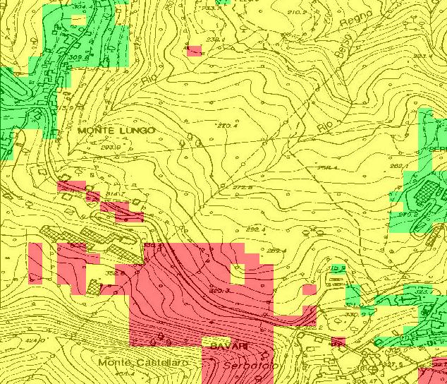

22 Critical analysis Results and validation Low Moderate High
23 Conclusions First conclusions Importance of preliminary analysis of the characteristics of the area to be subjected to zoning bivariate analysis Reliable factors: slope, land use, accumulation, distance to roads Importance of spatial variability of factors Strong influence of the characteristics of the calibration area on zoning results Calibration area: not too small, to be representative of all the conditions present in the area to be subjected to zoning, but of more homogeneous characteristics as possible
24 Conclusions Future work Guidelines for the susceptibility zoning for non-gis and non-statistical expert users Maps with indications of most suitable design solutions according to the characteristics of the critical zones
25 Conclusions Thank you for your attention This work is financed by the national research program (PRIN ) called Mitigation of landslide risk using sustainable actions coordinated by University of Salerno.
Landslide Hazard Assessment Methodologies in Romania
 A Scientific Network for Earthquake, Landslide and Flood Hazard Prevention SciNet NatHazPrev Landslide Hazard Assessment Methodologies in Romania In the literature the terms of susceptibility and landslide
Landslide Susceptibility, Hazard, and Risk Assessment. Twin Hosea W. K. Advisor: Prof. C.T. Lee
 Landslide Susceptibility, Hazard, and Risk Assessment Twin Hosea W. K. Advisor: Prof. C.T. Lee Date: 2018/05/24 1 OUTLINE INTRODUCTION LANDSLIDE HAZARD ASSESSTMENT LOGISTIC REGRESSION IN LSA STUDY CASE
Viale della Fiera 8 Bologna - Italy
 Assessment of landslides susceptibility and reactivation likelihood in the Emilia Romagna region (Italy) Mauro Generali e Marco Pizziolo Regione Emilia-Romagna Geological Survey Viale della Fiera 8 Bologna
A GIS-based statistical model for landslide susceptibility mapping: A case study in the Taleghan watershed, Iran
 Biological Forum An International Journal 7(2): 862-868(2015) ISSN No. (Print): 0975-1130 ISSN No. (Online): 2249-3239 A GIS-based statistical model for landslide susceptibility mapping: A case study in
Landslide susceptibility assessment over Europe according to the Tier 1 approach: Experiment and perspectives
 Landslide susceptibility assessment over Europe according to the Tier 1 approach: Experiment and perspectives Andreas Günther 1 & Paola Reichenbach 2 1 Bundesanstalt für Geowissenschaften und Rohstoffe
Landslide Hazard Zonation Methods: A Critical Review
 International Journal of Civil Engineering Research. ISSN 2278-3652 Volume 5, Number 3 (2014), pp. 215-220 Research India Publications http://www.ripublication.com/ijcer.htm Landslide Hazard Zonation Methods:
Geomorphology 182 (2013) Contents lists available at SciVerse ScienceDirect. Geomorphology. journal homepage:
 Contents lists available at SciVerse ScienceDirect. Geomorphology. journal homepage:") Geomorphology 182 (2013) 33 48 Contents lists available at SciVerse ScienceDirect Geomorphology journal homepage: www.elsevier.com/locate/geomorph Landslide zoning over large areas from a sample inventory
Geomorphology 182 (2013) 33 48 Contents lists available at SciVerse ScienceDirect Geomorphology journal homepage: www.elsevier.com/locate/geomorph Landslide zoning over large areas from a sample inventory
Response on Interactive comment by Anonymous Referee #1
 Response on Interactive comment by Anonymous Referee #1 Sajid Ali First, we would like to thank you for evaluation and highlighting the deficiencies in the manuscript. It is indeed valuable addition and
Need of Proper Development in Hilly Urban Areas to Avoid
 Need of Proper Development in Hilly Urban Areas to Avoid Landslide Hazard Dr. Arvind Phukan, P.E. Cosultant/Former Professor of Civil Engineering University of Alaska, Anchorage, USA RI District Governor
EU-level landslide susceptibility assessment
 in the context t of the Soil Thematic Strategy t Andreas Günther 1, Miet Van Den Eeckhaut 2, Paola Reichenbach h 3, Javier Hervás 2 & Jean-Philippe Malet 4 1 Federal Institute for Geosciences and Natural
Landslide Susceptibility Mapping Using Logistic Regression in Garut District, West Java, Indonesia
 Landslide Susceptibility Mapping Using Logistic Regression in Garut District, West Java, Indonesia N. Lakmal Deshapriya 1, Udhi Catur Nugroho 2, Sesa Wiguna 3, Manzul Hazarika 1, Lal Samarakoon 1 1 Geoinformatics
Landslide hazards zonation using GIS in Khoramabad, Iran
 Journal of Geotechnical Geology Winter 04, Vol. 9, No. 4: 4- www.geo-tech.ir Landslide hazards zonation using GIS in Khoramabad, Iran G. R. Khanlari *, Y. Abdilor & R. Babazadeh ) Associate Prof., Department
GIS Application in Landslide Hazard Analysis An Example from the Shihmen Reservoir Catchment Area in Northern Taiwan
 GIS Application in Landslide Hazard Analysis An Example from the Shihmen Reservoir Catchment Area in Northern Taiwan Chyi-Tyi Lee Institute of Applied Geology, National Central University, No.300, Jungda
12 th International Symposium on Landslides June 2016, Napoli (Italy)
") 12 th International Symposium on s 12-19 June 2016, Napoli (Italy) use of thematic for landslide susceptibility assessment by means of statistical : case study of shallow landslides in fine grained soils
12 th International Symposium on s 12-19 June 2016, Napoli (Italy) use of thematic for landslide susceptibility assessment by means of statistical : case study of shallow landslides in fine grained soils
Classification of Erosion Susceptibility
 GEO327G: GIS & GPS Applications in Earth Sciences Classification of Erosion Susceptibility Denali National Park, Alaska Zehao Xue 12 3 2015 2 TABLE OF CONTENTS 1 Abstract... 3 2 Introduction... 3 2.1 Universal
Geospatial Approach for Delineation of Landslide Susceptible Areas in Karnaprayag, Chamoli district, Uttrakhand, India
 Geospatial Approach for Delineation of Landslide Susceptible Areas in Karnaprayag, Chamoli district, Uttrakhand, India Ajay Kumar Sharma & Anand Mohan Singh Overview Landslide - movement of a mass of rock,
Landslide Hazard Investigation in Papua New Guinea-A Remote Sensing & GIS Approach
 Landslide Hazard Investigation in Papua New Guinea-A Remote Sensing & GIS Approach Sujoy Kumar Jana 1, Tingneyuc Sekac 2, Dilip Kumar Pal 3 Abstract: Tribal communities living in the mountainous regions
LANDSLIDE SUSCEPTIBILITY MAPPING USING INFO VALUE METHOD BASED ON GIS
 LANDSLIDE SUSCEPTIBILITY MAPPING USING INFO VALUE METHOD BASED ON GIS ABSTRACT 1 Sonia Sharma, 2 Mitali Gupta and 3 Robin Mahajan 1,2,3 Assistant Professor, AP Goyal Shimla University Email: sonia23790@gmail.com
Pinyol, Jordi González, Marta Oller, Pere Corominas, Jordi Martínez, Pere
 Rockfall hazard mapping methodology applied to the Geological Hazard Prevention Map in Catalonia 1:25000 Pinyol, Jordi González, Marta Oller, Pere Corominas, Jordi Martínez, Pere ROCKFALL HAZARD MAPPING
Harmonised approaches for landslide susceptibility mapping in Europe
 Harmonised approaches for landslide susceptibility mapping in Europe J. Hervás Institute for Environment and Sustainability, Joint Research Centre (JRC), European Commission, Ispra, Italy A. Günther Federal
A National Scale Landslide Susceptibility Assessment for St. Lucia, Caribbean Sea
 A National Scale Landslide Susceptibility Assessment for St. Lucia, Caribbean Sea Submitted by James Varghese As a part of M.Sc. Module On Empirical Modeling of Hazard Processes TABLE OF CONTENTS INTRODUCTION...
Criteria for identification of areas at risk of landslides in Europe: the Tier 1 approach
 Criteria for identification of areas at risk of landslides in Europe: the Tier 1 approach Andreas Günther 1, Paola Reichenbach 2, Fausto Guzzetti 2, Andreas Richter 1 1 Bundesanstalt für Geowissenschaften
A METHODOLOGY FOR ASSESSING EARTHQUAKE-INDUCED LANDSLIDE RISK. Agency for the Environmental Protection, ITALY (
 A METHODOLOGY FOR ASSESSING EARTHQUAKE-INDUCED LANDSLIDE RISK Roberto W. Romeo 1, Randall W. Jibson 2 & Antonio Pugliese 3 1 University of Urbino, ITALY (e-mail: rwromeo@uniurb.it) 2 U.S. Geological Survey
2013 Esri Europe, Middle East and Africa User Conference October 23-25, 2013 Munich, Germany
 2013 Esri Europe, Middle East and Africa User Conference October 23-25, 2013 Munich, Germany Environmental and Disaster Management System in the Valles Altos Region in Carabobo / NW-Venezuela Prof.Dr.habil.Barbara
APPLICATION OF REMOTE SENSING & GIS ON LANDSLIDE HAZARD ZONE IDENTIFICATION & MANAGEMENT
 APPLICATION OF REMOTE SENSING & GIS ON LANDSLIDE HAZARD ZONE IDENTIFICATION & MANAGEMENT PRESENTED BY SUPRITI PRAMANIK M.TECH IN ENVIRONMENTAL SCIENCE AND TECHNOLOGY NIT,DURGAPUR 25-04-2015 1 INTRODUCTION
Using Weather and Climate Information for Landslide Prevention and Mitigation
 Using Weather and Climate Information for Landslide Prevention and Mitigation Professor Roy C. Sidle Disaster Prevention Research Institute Kyoto University, Japan International Workshop on Climate and
Statistical Seismic Landslide Hazard Analysis: an Example from Taiwan
 Statistical Seismic Landslide Hazard Analysis: an Example from Taiwan Chyi-Tyi Lee Graduate Institute of Applied Geology, National Central University, Taiwan Seismology Forum 27: Natural Hazards and Surface
Fuzzy Logic Method for Landslide Susceptibility Mapping, Rio Blanco, Nicaragua
 Fuzzy Logic Method for Landslide Susceptibility Mapping, Rio Blanco, Nicaragua H. Schernthanner 1 1 University of Potsdam, Institute of Geography, GIS department, Karl-Liebknecht-Str. 24/25, 14476 Golm
Identifying Wildfire Risk Areas in Western Washington State
 Identifying Wildfire Risk Areas in Western Washington State Matthew Seto University of Washington Tacoma GIS Certification Program URISA 2015 Undergraduate Geospatial Skills Competition Introduction 2014
Debris flow: categories, characteristics, hazard assessment, mitigation measures. Hariklia D. SKILODIMOU, George D. BATHRELLOS
 Debris flow: categories, characteristics, hazard assessment, mitigation measures Hariklia D. SKILODIMOU, George D. BATHRELLOS Natural hazards: physical phenomena, active in geological time capable of producing
Landslide Susceptibility Mapping by Using Logistic Regression Model with Neighborhood Analysis: A Case Study in Mizunami City
 Int. J. of GEOMATE, Dec. Int. 2011, J. of Vol. GEOMATE, 1, No. 2 (Sl. Dec. No. 2011, 2), pp. Vol. 99-104 1, No. 2 (Sl. No. 2), pp. 99-104 Geotec., Const. Mat. and Env., ISSN:2186-2982(P), 2186-2990(O),
Investigation of landslide based on high performance and cloud-enabled geocomputation
 Investigation of landslide based on high performance and cloud-enabled geocomputation Jun Liu 1, Shuguang Liu 2,*, Qiming Zhou 3, Jing Qian 1 1 Shenzhen Institutes of Advanced Technology, Chinese Academy
FOREST FIRE HAZARD MODEL DEFINITION FOR LOCAL LAND USE (TUSCANY REGION)
") FOREST FIRE HAZARD MODEL DEFINITION FOR LOCAL LAND USE (TUSCANY REGION) C. Conese 3, L. Bonora 1, M. Romani 1, E. Checcacci 1 and E. Tesi 2 1 National Research Council - Institute of Biometeorology (CNR-
FOREST FIRE HAZARD MODEL DEFINITION FOR LOCAL LAND USE (TUSCANY REGION) C. Conese 3, L. Bonora 1, M. Romani 1, E. Checcacci 1 and E. Tesi 2 1 National Research Council - Institute of Biometeorology (CNR-
Flood Risk Map Based on GIS, and Multi Criteria Techniques (Case Study Terengganu Malaysia)
") Journal of Geographic Information System, 2015, 7, 348-357 Published Online August 2015 in SciRes. http://www.scirp.org/journal/jgis http://dx.doi.org/10.4236/jgis.2015.74027 Flood Risk Map Based on GIS,
Journal of Geographic Information System, 2015, 7, 348-357 Published Online August 2015 in SciRes. http://www.scirp.org/journal/jgis http://dx.doi.org/10.4236/jgis.2015.74027 Flood Risk Map Based on GIS,
Natural Terrain Risk Management in Hong Kong
 Natural Terrain Risk Management in Hong Kong Nick Koor Senior Lecturer in Engineering Geology School of Earth and Environmental Sciences Slope failures in Hong Kong Man-made Slope Failure - 300 landslides
Hendra Pachri, Yasuhiro Mitani, Hiro Ikemi, and Ryunosuke Nakanishi
 21 2nd International Conference on Geological and Civil Engineering IPCBEE vol. 8 (21) (21) IACSIT Press, Singapore DOI: 1.7763/IPCBEE. 21. V8. 2 Relationships between Morphology Aspect and Slope Failure
THE DIGITAL TERRAIN MAP LIBRARY: AN EXPLORATIONIST S RESOURCE
 THE DIGITAL TERRAIN MAP LIBRARY: AN EXPLORATIONIST S RESOURCE By I.C.L. Webster, P.J. Desjardins and W.E. Kilby KEYWORDS: digital terrain maps, digital terrain stability maps, surficial geology, GIS, raster
Land recycling and reusing: man made terraces as a peculiar problem in the Liguria region.
 Land recycling and reusing: man made terraces as a peculiar problem in the Liguria region. G. Brancucci and G. Paliaga & Francesca Nervi POLIS Department University of Genova - Italy The Ligurian territory
Vulnerability mapping for sustainable hazard mitigation in the city of Bukavu, South Kivu DRCongo
 IAG/AIG REGIONAL CONFERENCE, 18th to 22nd Feb. 2011 Vulnerability mapping for sustainable hazard mitigation in the city of Bukavu, South Kivu DRCongo Sadiki Ndyanabo 1, Ine Vandecasteele 2, Jan Moeyersons
Landslide Mapping and Hazard Analysis for a Natural Gas Pipeline Project
 CIVIL GOVERNMENT SERVICES MINING & METALS OIL, GAS & CHEMICALS POWER Albert Kottke, Mark Lee, & Matthew Waterman Landslide Mapping and Hazard Analysis for a Natural Gas Pipeline Project Technical Innovation
WGIA7 9th July, Noriko KISHIMOTO
 Utilizing Global Map for addressing Climate Change WGIA7 9th July, 2009 Seoul, Republic of Korea Noriko KISHIMOTO n-kishimoto@gsi.go.jp Geographic Survey Institute, JAPAN Outline of the Global Map What
INTERNATIONAL JOURNAL OF GEOMATICS AND GEOSCIENCES Volume 1, No 1, 2010
 An Integrated Approach with GIS and Remote Sensing Technique for Landslide Hazard Zonation S.Evany Nithya 1 P. Rajesh Prasanna 2 1. Lecturer, 2. Assistant Professor Department of Civil Engineering, Anna
Australian Journal of Basic and Applied Sciences. Landslide Hazard Mapping with New Topographic Factors: A Study Case of Penang Island, Malaysia
 Australian Journal of Basic and Applied Sciences, 8(4) Special 014, Pages: 387-39 AENSI Journals Australian Journal of Basic and Applied Sciences ISSN:1991-8178 Journal home page: www.ajbasweb.com Landslide
Erosion Susceptibility in the area Around the Okanogan Fire Complex, Washington, US
 Erosion Susceptibility in the area Around the Okanogan Fire Complex, Washington, US 1. Problem Construct a raster that represents susceptibility to erosion based on lithology, slope, cover type, burned
Evaluation of Landslide Hazard Assessment Models at Regional Scale (SciNet NatHazPrev Project)
") Evaluation of Landslide Hazard Assessment Models at Regional Scale (SciNet NatHazPrev Project) Democritus University of Thrace (P1) Department of Civil Engineering Geotechnical Division Scientific Staff:
Evaluation of Landslide Hazard Assessment Models at Regional Scale (SciNet NatHazPrev Project) Democritus University of Thrace (P1) Department of Civil Engineering Geotechnical Division Scientific Staff:
CHAPTER GEOLOGICALLY HAZARDOUS AREAS Applicability Regulations.
 CHAPTER 19.07 GEOLOGICALLY HAZARDOUS AREAS 19.07.010 Applicability. Geologically hazardous areas may pose a threat to the health and safety of citizens when incompatible development is sited in areas of
INTERNATIONAL JOURNAL OF GEOMATICS AND GEOSCIENCES Volume 7, No 1, 2016
 INTERNATIONAL JOURNAL OF GEOMATICS AND GEOSCIENCES Volume 7, No 1, 2016 Copyright by the authors - Licensee IPA- Under Creative Commons license 3.0 Research article ISSN 0976 4380 Landslide susceptibility
Investigation, assessment and warning zonation for landslides in the mountainous regions of Vietnam
 Investigation, assessment and warning zonation for landslides in the mountainous regions of Vietnam (State-Funded Landslide Project SFLP) Dr. Eng. Le Quoc Hung Add: 67 Chien Thang Street, Ha Dong District,
GIS ANALYSIS OF DRIVERS OF EROSION AND GULLYING IN SOUTHEAST NIGERIA
 GIS ANALYSIS OF DRIVERS OF EROSION AND GULLYING IN SOUTHEAST NIGERIA Mayowa FASONA & Ademola OMOJOLA Department of Geography University of Lagos, Nigeria mfasona@unilag.edu.ng Outline Background Methodology
Landslide Susceptibility Model of Tualatin Mountains, Portland Oregon. By Tim Cassese and Colby Lawrence December 10, 2015
 Landslide Susceptibility Model of Tualatin Mountains, Portland Oregon By Tim Cassese and Colby Lawrence December 10, 2015 Landslide Closes Highway 30 at St. John's Bridge Introduction: Study Area: Tualatin
RISK ASSESSMENT METHODOLOGIES FOR LANDSLIDES
 RISK ASSESSMENT METHODOLOGIES FOR LANDSLIDES Jean-Philippe MALET Olivier MAQUAIRE CNRS & CERG. Welcome to Paris! 1 Landslide RAMs Landslide RAM A method based on the use of available information to estimate
Practical reliability approach to urban slope stability
 University of Wollongong Research Online Faculty of Engineering - Papers (Archive) Faculty of Engineering and Information Sciences 2011 Practical reliability approach to urban slope stability R. Chowdhury
Landslides Management in Rural Roads of Pauri District (Uttarakhand): Challenges & Opportunities
: Challenges & Opportunities") Landslides Management in Rural Roads of Pauri District (Uttarakhand): Challenges & Opportunities Shakti Prakash 1 & V.V.S. Gulati 2 1 Corrosponding author, Environment Specialist, 2 Team Leader (Uttarakhand
Landslides Management in Rural Roads of Pauri District (Uttarakhand): Challenges & Opportunities Shakti Prakash 1 & V.V.S. Gulati 2 1 Corrosponding author, Environment Specialist, 2 Team Leader (Uttarakhand
The Safety project: Updating geohazard activity maps with Sentinel-1data
 The Safety project: Updating geohazard activity maps with Sentinel-1data Oriol Monserrat a, Safety Consortium a Centre Tecnològic de Telecomunicacions de Catalunya (CTTC/CERCA), Division of Geomatics,
EO Information Services. Assessing Vulnerability in the metropolitan area of Rio de Janeiro (Floods & Landslides) Project
 Project") EO Information Services in support of Assessing Vulnerability in the metropolitan area of Rio de Janeiro (Floods & Landslides) Project Ricardo Armas, Critical Software SA Haris Kontoes, ISARS NOA World
EO Information Services in support of Assessing Vulnerability in the metropolitan area of Rio de Janeiro (Floods & Landslides) Project Ricardo Armas, Critical Software SA Haris Kontoes, ISARS NOA World
GIS as a tool in flood management
 GIS for the United Nations and the International Community Conference Panel: GIS and Capacity - How Territorial Planning Benefits from Geospatial Information 3-5 April 2012 Geneva, Switzerland GIS as a
Eagle Creek Post Fire Erosion Hazard Analysis Using the WEPP Model. John Rogers & Lauren McKinney
 Eagle Creek Post Fire Erosion Hazard Analysis Using the WEPP Model John Rogers & Lauren McKinney Columbia River Gorge at Risk: Using LiDAR and GIS-based predictive modeling for regional-scale erosion susceptibility
Geo-hazard Potential Mapping Using GIS and Artificial Intelligence
 Geo-hazard Potential Mapping Using GIS and Artificial Intelligence Theoretical Background and Uses Case from Namibia Andreas Knobloch 1, Dr Andreas Barth 1, Ellen Dickmayer 1, Israel Hasheela 2, Andreas
GIS model & modeling
 GIS model & modeling Model : a simplified representation of a phenomenon or a system. GIS modeling : the use of GIS in the process of building models with spatial data. Basic requirement in modeling :
Applying Hazard Maps to Urban Planning
 Applying Hazard Maps to Urban Planning September 10th, 2014 SAKAI Yuko Disaster Management Expert JICA Study Team for the Metro Cebu Roadmap Study on the Sustainable Urban Development 1 Contents 1. Outline
The Safeland Project General Overview and Monitoring Technology Development
 Ber. Geol. B. A., 82, ISSN 1017 8880 Landslide Monitoring Technologies & Early Warning Systems The Safeland Project General Overview and Monitoring Technology Development The SafeLand Consortium a), N.
THE IFFI PROJECT (ITALIAN LANDSLIDE INVENTORY): METHODOLOGY AND RESULTS
: METHODOLOGY AND RESULTS") THE IFFI PROJECT (ITALIAN LANDSLIDE INVENTORY): METHODOLOGY AND RESULTS Luca Guerrieri, Alessandro Trigila & Carla Iadanza Experts meeting on guidelines for mapping areas at risk of landslides in Europe
THE IFFI PROJECT (ITALIAN LANDSLIDE INVENTORY): METHODOLOGY AND RESULTS Luca Guerrieri, Alessandro Trigila & Carla Iadanza Experts meeting on guidelines for mapping areas at risk of landslides in Europe
LANDSLIDE HAZARD MAPPING BY USING GIS IN THE LILLA EDET PROVINCE OF SWEDEN
 LANDSLIDE HAZARD MAPPING BY USING GIS IN THE LILLA EDET PROVINCE OF SWEDEN Arzu ERENER 1, Suzanne LACASSE 2, Amir M. KAYNIA 3 1 Geodetic and Geographic Information Technologies, Middle East Technical University,
Landslide hazard assessment in the Khelvachauri area, Georgia
 Report on the project of AES Geohazards Stream Landslide hazard assessment in the Khelvachauri area, Georgia May 2010 George Jianping Panisara Gaprindashvili Guo Daorueang Institute of Geo-Information
Multi-stage Statistical Landslide Hazard Analysis: Earthquake-Induced Landslides
 Multi-stage Statistical Landslide Hazard Analysis: Earthquake-Induced Landslides Chyi-Tyi Lee Abstract Landslides are secondary or induced features, whose recurrence is controlled by the repetition of
Alaska, USA. Sam Robbins
 Using ArcGIS to determine erosion susceptibility within Denali National Park, Alaska, USA Sam Robbins Introduction Denali National Park is six million acres of wild land with only one road and one road
Estimation of landslides activities evolution due to land use changes in a Pyrenean valley
 Estimation of landslides activities evolution due to land use changes in a Pyrenean valley R. Vandromme, N. Desramaut, S. Bernardie, G. Grandjean 1 Introduction (1) > Need to produce dynamic susceptibility
Relative soil vulnerability and patterns of erosion during the muddy floods of on the South Downs, Sussex, UK
 Relative soil vulnerability and patterns of erosion during the muddy floods of 2000-2001 on the South Downs, Sussex, UK Hazel Faulkner, Jose Luis Ruiz & John Boardman South Downs East Sussex Due to a long
Abdolreza Ansari Amoli. Remote Sensing Department Iranian Space Agency
 Risk Assessment and Mapping Using Earth Observation Data In Iran Abdolreza Ansari Amoli Remote Sensing & GIS Expert Remote Sensing Department Iranian Space Agency Different Types of Disasters in Iran Epidemic
GIS-aided Statistical Landslide Susceptibility Modeling And Mapping Of Antipolo Rizal (Philippines)
") IOP Conference Series: Earth and Environmental Science PAPER OPEN ACCESS GIS-aided Statistical Landslide Susceptibility Modeling And Mapping Of Antipolo Rizal (Philippines) To cite this article: A J Dumlao
IOP Conference Series: Earth and Environmental Science PAPER OPEN ACCESS GIS-aided Statistical Landslide Susceptibility Modeling And Mapping Of Antipolo Rizal (Philippines) To cite this article: A J Dumlao
New Method for Landslide Stabilization
 New Method for Landslide Stabilization Ataollah DadashpourEmail: dadashpour2006@yahoo.com Prof. Robert Minasyan Email: hydroscope@netsys.am Seyyed Ali Hamidi Email: s_ali_hamidi@yahoo.com Mahmoud Shirchi
Workshop on Drought and Extreme Temperatures: Preparedness and Management for Sustainable Agriculture, Forestry and Fishery
 Workshop on Drought and Extreme Temperatures: Preparedness and Management for Sustainable Agriculture, Forestry and Fishery 16-17 Feb.2009, Beijing, China Modeling Apple Tree Bud burst time and frost risk
EMERGENCY PLANNING IN NORTHERN ALGERIA BASED ON REMOTE SENSING DATA IN RESPECT TO TSUNAMI HAZARD PREPAREDNESS
 EMERGENCY PLANNING IN NORTHERN ALGERIA BASED ON REMOTE SENSING DATA IN RESPECT TO TSUNAMI HAZARD PREPAREDNESS Barbara Theilen-Willige Technical University of Berlin, Institute of Applied Geosciences Department
International Symposium on Natural Disaster Mitigation. Local vulnerability assessment of landslides and debris flows
 International Symposium on Natural Disaster Mitigation of landslides and debris flows Lessons learnt from Cam Pha town and Van Don district, Quang Ninh province, Vietnam Nguyen Quoc Phi Faculty of Environment
UN-GGIM: Europe ExCom 1 June 2016 Francfort Work Group A «Core Data» Status and Progress François Chirié, France
 UN-GGIM: Europe ExCom 1 June 2016 Francfort Work Group A «Core Data» Status and Progress François Chirié, France Plan The Core Data Scope Deliverable 7-8 June 2016 WGA workshop to investigate work plans
DROUGHT RISK EVALUATION USING REMOTE SENSING AND GIS : A CASE STUDY IN LOP BURI PROVINCE
 DROUGHT RISK EVALUATION USING REMOTE SENSING AND GIS : A CASE STUDY IN LOP BURI PROVINCE K. Prathumchai, Kiyoshi Honda, Kaew Nualchawee Asian Centre for Research on Remote Sensing STAR Program, Asian Institute
Data Mining Approach For Landslide Susceptibility Mapping For Kundhapallam Watershed, Nilgiris, TamilNadu Dr. P. Rajesh Prasanna 1, S.
 Data Mining Approach For Landslide Susceptibility Mapping For Kundhapallam Watershed, Nilgiris, TamilNadu Dr. P. Rajesh Prasanna 1, S.Evany Nithya 2 1 Professor, Anna University Tiruchirappalli 2 Asst.
LUCAS: current product and its evolutions
 LUCAS: current product and its evolutions Workshop Land Use and Land Cover products: challenges and opportunities Brussels 15 Nov 2017 Eurostat E4: estat-dl-lucas@ec.europa.eu Contents 1) The context 2)
SPATIAL MODELS FOR THE DEFINITION OF LANDSLIDE SUSCEPTIBILITY AND LANDSLIDE HAZARD. J.L. Zêzere Centre of Geographical Studies University of Lisbon
 SPATIAL MODELS FOR THE DEFINITION OF LANDSLIDE SUSCEPTIBILITY AND LANDSLIDE HAZARD J.L. Zêzere Centre of Geographical Studies University of Lisbon CONCEPTUAL MODEL OF LANDSLIDE RISK Dangerous Phenomena
Report. Developing a course component on disaster management
 Report Developing a course component on disaster management By Chira Prangkio Tawee Chaipimonplin Department of Geography, Faculty of Social Sciences, Chiang Mai University Thailand Presented at Indian
Landslide Hazard Assessment Models at Regional Scale (SciNet NatHazPrev Project)
") Landslide Hazard Assessment Models at Regional Scale (SciNet NatHazPrev Project) Democritus University of Thrace (P1) Department of Civil Engineering Geotechnical Division Scientific Staff: Dr Nikolaos
Landslide Hazard Assessment Models at Regional Scale (SciNet NatHazPrev Project) Democritus University of Thrace (P1) Department of Civil Engineering Geotechnical Division Scientific Staff: Dr Nikolaos
Landslide susceptibility mapping along pipeline corridors in Canada. Andrée Blais-Stevens Réjean Couture
 Landslide susceptibility mapping along pipeline corridors in Canada Andrée Blais-Stevens Réjean Couture 2 Outline Pipelines in Canada Two regional studies: Northwest Territories & British Columbia Future
GEOMORPHOLOGY APPROACH IN LANDSLIDE VULNERABILITY, TANJUNG PALAS TENGAH, EAST KALIMANTAN, INDONESIA
 GEOMORPHOLOGY APPROACH IN LANDSLIDE VULNERABILITY, TANJUNG PALAS TENGAH, EAST KALIMANTAN, INDONESIA *Twin H. W. Kristyanto Geology Study Program, FMIPA UI, Universitas Indonesia *Author for Correspondence:
International Journal of Modern Trends in Engineering and Research e-issn No.: , Date: April, 2016
 International Journal of Modern Trends in Engineering and Research www.ijmter.com e-issn No.:2349-9745, Date: 28-30 April, 2016 Landslide Hazard Management Maps for Settlements in Yelwandi River Basin,
MANAGEMENT OF LARGE MUDSLIDES
 36 MANAGEMENT OF LARGE MUDSLIDES Three large and active mudslides Poche, 1860?, Super-Sauze, 1960?, La Valette, March 1982, 1 M m 3 900,000 m 3 4-5 M m 3 37 Three large and active mudslides Type of development:
UNSD SEEA-EEA revision 2020
 UNSD SEEA-EEA revision 2020 Area 1: Spatial units; introduction Sjoerd Schenau, Patrick Bogaart, Edwin Horlings London group meeting, October 2018 Overview Spatial units in SEEA EEA Main revision issues
Towards a multivariate geogenic radon hazard index
 Towards a multivariate geogenic radon hazard index P. Bossew 1, G. Cinelli 2, T. Tollefsen 2, M. DeCort 2 1 German Federal Office for Radiation Protection, Berlin 2 European Commission, Joint Research
Rainfall-induced landslide susceptibility zonation of Puerto Rico
 DOI 10.1007/s12665-011-0976-1 SPECIAL ISSUE Rainfall-induced landslide susceptibility zonation of Puerto Rico Chiara Lepore Sameer A. Kamal Peter Shanahan Rafael L. Bras Received: 30 July 2010 / Accepted:
5/3/2018 Susceptibility analysis of landslide due to earthquake due in Gorkha (25th April 2015) Animesh Bahadur Pradhan GIS IN WATER RESOURCES CE 547
 Animesh Bahadur Pradhan GIS IN WATER RESOURCES CE 547") Susceptibility 5/3/2018 analysis of landslide due to earthquake due in Gorkha (25th April 2015) Animesh Bahadur Pradhan GIS IN WATER RESOURCES CE 547 Contents 1. Acknowledgement:... 2 2. Motivation and
Susceptibility 5/3/2018 analysis of landslide due to earthquake due in Gorkha (25th April 2015) Animesh Bahadur Pradhan GIS IN WATER RESOURCES CE 547 Contents 1. Acknowledgement:... 2 2. Motivation and
GIS based high speed railway between Calgary-Red Deer-Edmonton
 Capstone Project BGIS Bachel o r of A p p l i ed Technology in G eographic I n f o r m a tion S y s tems GIS based high speed railway between Calgary-Red Deer-Edmonton Sisay Bayafers Arshdeep Virk Jordan
EIT-Japan Symposium 2011 on Human Security Engineering
 EIT-Japan Symposium 2011 on Human Security Engineering 2011 Disastrous Landslides at Khao Panom, Krabi, Thailand Suttisak Soralump Geotechnical Engineering Research and Development Center (GERD) Faculty
GIS and Multicriteria Analysis to Evaluate and Map Erosion and Landslide Hazards
 INFORMATICA, 2001, Vol. 12, No. 1, 25 44 25 2001 Institute of Mathematics and Informatics, Vilnius GIS and Multicriteria Analysis to Evaluate and Map Erosion and Landslide Hazards Anna CAVALLO CSI- Piemonte,
Land Administration and Cadastre
 Geomatics play a major role in hydropower, land and water resources and other infrastructure projects. Lahmeyer International s (LI) worldwide projects require a wide range of approaches to the integration
IDENTIFICATION OF LANDSLIDE-PRONE AREAS USING REMOTE SENSING TECHNIQUES
 5.1 IDENTIFICATION OF LANDSLIDE-PRONE AREAS USING REMOTE SENSING TECHNIQUES P.V. Seethapathi National Institute of Hydrology Jal Vigyan Bhawan, Roorkee-247 667, Uttarakhand Email: neriwalam@gwl.net.in
UNIVERSITI TEKNOLOGI MARA
 UNIVERSITI TEKNOLOGI MARA GEOGRAPHICAL INFORMATION SYSTEM (GIS) BASED MULTI CRITERIA DECISION MAKING (MCDM) FOR LANDSLIDE HAZARD ZONATION: A CASE STUDY OF AMPANG JAYA MUNICIPAL COUNCIL AINON NISA OTHMAN
Land Use/Cover Changes & Modeling Urban Expansion of Nairobi City
 Land Use/Cover Changes & Modeling Urban Expansion of Nairobi City Overview Introduction Objectives Land use/cover changes Modeling with Cellular Automata Conclusions Introduction Urban land use/cover types
Grant 0299-NEP: Water Resources Project Preparatory Facility
 Document Produced under Grant Project Number: 45206 May 2016 Grant 0299-NEP: Water Resources Project Preparatory Facility Final Report Volume 3 East Rapti (1 of 9) Prepared by Pvt. Ltd. For Ministry of
THE 3-REGIONS WORKING GROUP SLOPE INSTABILITIES (SlopeIn)
") Bayerisches Landesamt für Umwelt THE 3-REGIONS WORKING GROUP SLOPE INSTABILITIES (SlopeIn) COMMON LANGUAGE, COMPARABLE HAZARD MAPPING AND SHARED EXPERIENCES ACROSS EUROPE The 3-Regions Working-Group SlopeIn:
Bayerisches Landesamt für Umwelt THE 3-REGIONS WORKING GROUP SLOPE INSTABILITIES (SlopeIn) COMMON LANGUAGE, COMPARABLE HAZARD MAPPING AND SHARED EXPERIENCES ACROSS EUROPE The 3-Regions Working-Group SlopeIn:
Delta Flood Protection Strategy Update. May 16, 2016
 Delta Flood Protection Strategy Update May 16, 2016 Presentation Overview 1. Background 2. Understanding the Dike Reaches/Issues 3. Future Dike Improvements 4. Next Steps Boundary Bay Village March 10,
Landslide hazard and risk management in the Barcelonnette Basin: some case studies
 Intensive Course Barcelona, UPC, 1-4 September 2008 Landslide hazard and risk management in the Barcelonnette Basin: some case studies J.-P. Malet 1, A. Remaître 1, Y. Thiery 1 O. Maquaire 2, M. Peyron