THE 3-REGIONS WORKING GROUP SLOPE INSTABILITIES (SlopeIn)
|
|
|
- Liliana Elliott
- 6 years ago
- Views:
Transcription


1 Bayerisches Landesamt für Umwelt THE 3-REGIONS WORKING GROUP SLOPE INSTABILITIES (SlopeIn) COMMON LANGUAGE, COMPARABLE HAZARD MAPPING AND SHARED EXPERIENCES ACROSS EUROPE

, Barcelona (1997), Munich (2000)")
2 The 3-Regions Working-Group SlopeIn: History: 1992: Start of the informal collaboration between the Geological Surveys of Emilia-Romagna, Catalonia and Bavaria in the fields of the Earths Science and Information Systems. Organisation of conferences in Bologna (1994), Barcelona (1997), Munich (2000) and Bologna (2003) 2
3 The 3-Regions Working-Group SlopeIn: History: November the 19th, 2004: Based on this collaboration programme an Agreement Protocol was signed between: Regione Emilia-Romagna Generalitat de Catalunya Free State Bavaria 3
4 The 3-Regions Working-Group SlopeIn: History: November the 19th,
5 The 3-Regions Working-Group SlopeIn: History: November the 19th, 2004 Main one main target of the Agreement Protocol: assess hazards, minimising risks and maximising awareness to enhance sustainable development and quality of life 5
6 The 3-Regions Working-Group SlopeIn: History: Following: 2006: Organisation of the conference in Barcelona 2009: Organisation of the conference in Munich 6
7 The 3-Regions Working-Group SlopeIn: History: At the last conference in Munich 2009 the Organising Committee decided to implement different working groups in order to strengthen the collaboration in particular areas of interest of the three regions. One working group was called Land Instabilities. Slope Instabilities Working Group SlopeIn 7
8 The SlopeIn Working Group: Members: Marta González, Institut Geològic de Catalunya, Giovanni Bertolini, Servizio Geologico, Sismico e dei Suoli Regione Emilia Romagna, GBertolini@regione.emilia-romagna.it Karl Mayer,, Karl.Mayer@lfu.bayern.de 8
9 Results of the collaboration of SlopeIn: European AdaptAlp Project (Adaptation to climate change in the Alpine space) Multilingual glossary for landslides. Minimum Requirements for the creation of hazard maps and methodologies. 9
10 Results of the collaboration of SlopeIn: AdaptAlp Land Kärnten (Dep. Environment) Federal Office for the Environment (Swiss) Geological Survey of Slovenia Institut Geologic de Catalunya (Spain) Servicio Geologico, Sismico e del Suoli (Emilia-Romagna, Italy) Office National des Forets (RTM) Britisch Geological Survey 10
11 Development of a multilingual glossary for geological hazards 11
12 Development of a multilingual glossary for geological hazards Overview of the database model components Auxiliary tables 12

13 For filling the Glossary with contents SlopeIn took the responsibility for Catalan, Spanish, German and Italian language 13

14 The Glossary: 14

15 The Glossary: 15
16 The Glossary: 16


17 The Glossary: Terms which are used in the Geological Surveys of the 17
18 Harmonisation of terminology and definitions for different maps 18
19 Harmonisation of terminology and definitions for different maps Because of the inconsistent usage of terms and definitions the comparability of susceptibility, hazard and risk maps is very difficult. This fact could cause understanding problems. Therefore three common definitions for three main types of maps were elaborated inside a Workshop held in Munich at December
20 Harmonisation of terminology and definitions for different maps Definitions Landslide Susceptibility Map Level 1 Landslide Susceptibility Map Level 2 Landslide Hazard Map 20
21 Harmonisation of terminology and definitions for different maps Landslide Susceptibility Map Level 1 A Landslide Susceptibility Map (Level 1) is used for the first identification of areas showing conflicts of interests or areas under suspicion to be hazardous. It is a map created on objective, scientific criteria with information on hazard susceptibility, which are not analysed, identified and localised in detail. With empirical, statistical or deterministic methods these maps show the basic disposition for the development of landslides. In general only the potential detachment zone of the landslides is shown and no classification of different hazard levels (probability and intensity) is done. 21
22 Harmonisation of terminology and definitions for different maps Landslide Susceptibility Map Level 2 A Landslide Susceptibility Map (Level 2) is used for the first identification of areas showing conflicts of interests or areas under suspicion to be hazardous. It is a map created on objective, scientific criteria with information on hazard susceptibility, which are analysed, identified and localised. With empirical, statistical or deterministic methods these maps show the basic disposition for the development of landslides. In general the whole process areas of the landslides and the propagation areas are shown (potential detachment and runout zone) and no classification of different hazard levels (probability and intensity) is done. 22
23 Harmonisation of terminology and definitions for different maps Hazard Map A Landslide Hazard Map builds the base for urban land use planning and the development and the costing of protective measures. It is a map created on objective, scientific criteria with information to hazard, which are analysed, identified and localised in detail. With empirical, statistical or deterministic methods in general the whole process areas of the different types of landslides, including the propagation areas are considered (potential detachment and runout zone) and a classification of different hazard levels based on probability and intensity is done. 23
")
24 Comparison of the different maps in our countries (Based on the new definitions) 24
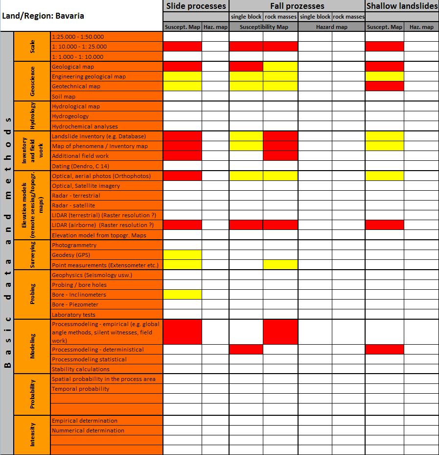
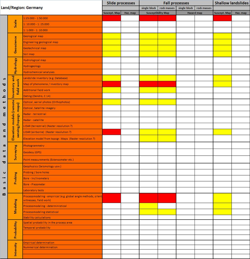
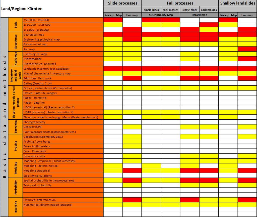
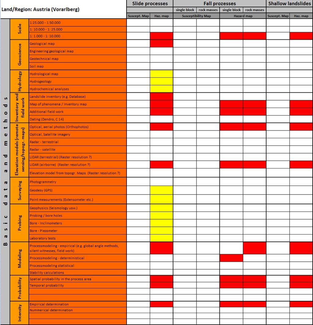
25 Minimum requirements for susceptibility and hazard maps Evaluation of the requirements in every particular country 25

26 Minimum requirements for susceptibility and hazard maps 26


27 Minimum requirements for susceptibility and hazard maps Publications: Multilingual Glossary Multilingual Glossary and final report enbewegungen/glossar/index.htm 27
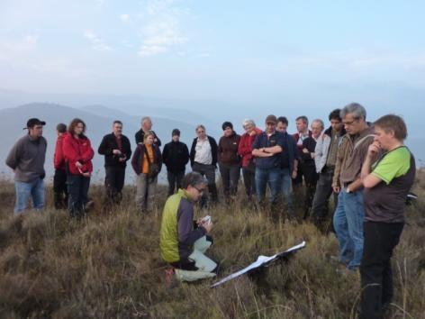
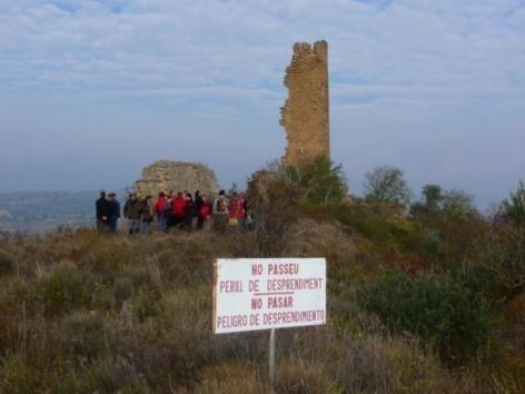
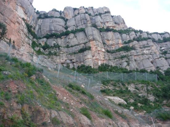
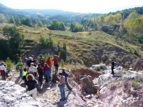
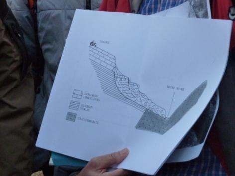
28 Results of the collaboration of SlopeIn: Organization of a technical excursion for specialists to landslides and debris flows in Catalonia. 28 excursion participants from Geological Surveys, Water Authorities, Road Authorities and Universities of Catalonia, France, Austria and Germany have been guided by the IGC collaborators to the most important subsidence, landslide and debris flow sites in Catalonia. 28

29 Technical Excursion to Catalonia: 29

30 Technical Excursion to Catalonia: 30
31 Technical Excursion to Catalonia: 31

32 Technical Excursion to Catalonia: 28 excursion participants from Geological Surveys, Water Authorities, Road Authorities and Universities of Catalonia, France, Austria and Germany have been guided by the IGC collaborators to the most important subsidence, landslide and debris flow sites in Catalonia. 32
33 Results of the collaboration of SlopeIn: The 7th congress of Bologna 2012: Organization and of the Session 1 Slope Instabilities in the congress of Bologna in

34 Results of the collaboration of SlopeIn: The 7th congress of Bologna 2012: Organization and of the Session 1 Slope Instabilities in the congress of Bologna in Chairman Professore Nicola Casagli - University of Firenze 34
European. for Earth. Cooperation of Geological Surveys of. Generalitat de Catalunya
 European Regions for Earth Sciences Cooperation of Geological Surveys of Catalonia, Emilia-Romagna and Bavaria Generalitat de Catalunya 2 GEOLOGICAL SURVEYS IN The XXI Century The 21 st century pushed
Contribution to the Mountain-Risks project of the Rock Mechanics Laboratory of the Swiss Federal Institute of Technology of Lausanne
 Contribution to the Mountain-Risks project of the Rock Mechanics Laboratory of the Swiss Federal Institute of Technology of Lausanne PhD Student: Jacopo Abbruzzese Supervisor: Dr. Vincent Labiouse MOUNTAIN
Pinyol, Jordi González, Marta Oller, Pere Corominas, Jordi Martínez, Pere
 Rockfall hazard mapping methodology applied to the Geological Hazard Prevention Map in Catalonia 1:25000 Pinyol, Jordi González, Marta Oller, Pere Corominas, Jordi Martínez, Pere ROCKFALL HAZARD MAPPING
third circular and programme
 7 th EUREGEO Bologna Italy june 12 th - 15 th 2012 EUropean Congress on REgional GEOscientific Cartography and Sustainable Information Systems Geo-Management From 12 th to 15 th June 2012, the on REgional
PROTOCOL ON THE IMPLEMENTATION OF THE ALPINE CONVENTION OF 1991 RELATING TO SPATIAL PLANNING AND SUSTAINABLE DEVELOPMENT
 PROTOCOL ON THE IMPLEMENTATION OF THE ALPINE CONVENTION OF 1991 RELATING TO SPATIAL PLANNING AND SUSTAINABLE DEVELOPMENT SPATIAL PLANNING AND SUSTAINABLE DEVELOPMENT" PROTOCOL Preamble The Republic of
The Safeland Project General Overview and Monitoring Technology Development
 Ber. Geol. B. A., 82, ISSN 1017 8880 Landslide Monitoring Technologies & Early Warning Systems The Safeland Project General Overview and Monitoring Technology Development The SafeLand Consortium a), N.
The UN discusses Global Geospatial Information Management
 The UN discusses Global Geospatial Information Management Just like statistics, every country must have authoritative, trusted, maintained, definitive mapping data Professor Paul Cheung, Director, United
Disaster Information System of Alpine Regions. DIS-ALP powered by Means of the European Regional Development Fund (ERDF)
") DIS-ALP Disaster Information System of Alpine Regions DIS-ALP powered by Means of the European Regional Development Fund (ERDF) DIS-ALP Disaster InformationSystem of Alpine Regions General Information
DIS-ALP Disaster Information System of Alpine Regions DIS-ALP powered by Means of the European Regional Development Fund (ERDF) DIS-ALP Disaster InformationSystem of Alpine Regions General Information
RISK ASSESSMENT METHODOLOGIES FOR LANDSLIDES
 RISK ASSESSMENT METHODOLOGIES FOR LANDSLIDES Jean-Philippe MALET Olivier MAQUAIRE CNRS & CERG. Welcome to Paris! 1 Landslide RAMs Landslide RAM A method based on the use of available information to estimate
Criteria for identification of areas at risk of landslides in Europe: the Tier 1 approach
 Criteria for identification of areas at risk of landslides in Europe: the Tier 1 approach Andreas Günther 1, Paola Reichenbach 2, Fausto Guzzetti 2, Andreas Richter 1 1 Bundesanstalt für Geowissenschaften
Landslide hazard and risk management in the Barcelonnette Basin: some case studies
 Intensive Course Barcelona, UPC, 1-4 September 2008 Landslide hazard and risk management in the Barcelonnette Basin: some case studies J.-P. Malet 1, A. Remaître 1, Y. Thiery 1 O. Maquaire 2, M. Peyron
M. Mikoš. Faculty of Civil and Geodetic Engineering, University of Ljubljana, Ljubljana, Slovenia
 Proceedings of the Mediterranean Meeting on Monitoring, modelling and early warning of extreme events triggered by heavy rainfalls. PON 01_01503 - MED-FRIEND project University of Calabria, Cosenza (Italy),
Landslide Susceptibility Model of Tualatin Mountains, Portland Oregon. By Tim Cassese and Colby Lawrence December 10, 2015
 Landslide Susceptibility Model of Tualatin Mountains, Portland Oregon By Tim Cassese and Colby Lawrence December 10, 2015 Landslide Closes Highway 30 at St. John's Bridge Introduction: Study Area: Tualatin
Innovative Ways to Monitor Land Displacement
 ARTICLE Innovative Ways to Monitor Land Displacement When people think about landslides, they usually imagine large mud streams which cause considerable loss of life. Whereas such large-scale disasters
EuroGeoSurveys An Introduction
 EGS -ASGMI Workshop, Madrid, 2015 EuroGeoSurveys An Introduction 40 Years Listening to the Beat of the Earth Click to edit Master title Albania style EuroGeoSurveys Austria Lithuania Luxembourg Belgium
LIST OF DOCUMENTS* GROUP OF EXPERTS ON GEOGRAPHICAL NAMES. Twenty-seventh session 15 June 2016 New York, 28 April 2 May 2014
 UNITED NATIONS GROUP OF EXPERTS ON GEOGRAPHICAL NAMES GEGN/29/5/Rev.4 Twenty-seventh session 15 June 2016 New York, 28 April 2 May 2014 LIST OF DOCUMENTS* * Prepared by the UNGEGN Secretariat Symbol Title/Country
The Safety project: Updating geohazard activity maps with Sentinel-1data
 The Safety project: Updating geohazard activity maps with Sentinel-1data Oriol Monserrat a, Safety Consortium a Centre Tecnològic de Telecomunicacions de Catalunya (CTTC/CERCA), Division of Geomatics,
A.G./ A.I.G. S EDIBUD
 I.A.G./A.I.G. SEDIBUD Annual Report for 2006 (by Achim A. Beylich, January 2007) SEDIBUD I.A.G./A.I.G. SEDIBUD Sediment Budgets in Cold Environments Chair: Assoc. Professor Achim A. Beylich (Trondheim,
PLATFORM ON NATURAL HAZARDS ALPINE CONVENTION PLANALP OF THE. Historical flood in August 2005, Bern, Switzerland (Picture: Simone Hunziker, FOEN)
") PLATFORM ON NATURAL HAZARDS OF THE ALPINE CONVENTION PLANALP Historical flood in August 2005, Bern, Switzerland (Picture: Simone Hunziker, FOEN) 1 1. What is Platform on Natural Hazards of the Alpine Convention
PLATFORM ON NATURAL HAZARDS OF THE ALPINE CONVENTION PLANALP Historical flood in August 2005, Bern, Switzerland (Picture: Simone Hunziker, FOEN) 1 1. What is Platform on Natural Hazards of the Alpine Convention
2013 Esri Europe, Middle East and Africa User Conference October 23-25, 2013 Munich, Germany
 2013 Esri Europe, Middle East and Africa User Conference October 23-25, 2013 Munich, Germany Environmental and Disaster Management System in the Valles Altos Region in Carabobo / NW-Venezuela Prof.Dr.habil.Barbara
SYLLABUS. 1. Course description. Environmental Sciences. Physical, Chemical and Natural Systems Year: ECTS credits: 4.5.
 1. Course description Degree: Environmental Sciences Course: Natural Hazards Department: Physical, Chemical and Natural Systems Year: 2017-18 Term: Fall ECTS credits: 4.5 Course: 3 rd year Type: Basic
European Forum for Geography & Statistics Conference 2018
 European Forum for Geography & Statistics Conference 2018 Welcome speech Dr. Janusz Dygaszewicz EFGS President Director of ICT Systems, Geostatistics and Census Department Statistics Poland Helsinki, Finland,
ACTION PLAN FOR WORLD HERITAGE IN LATIN AMERICA AND THE CARIBBEAN ( )
") Annex ACTION PLAN FOR WORLD HERITAGE IN LATIN AMERICA AND THE CARIBBEAN (2014-2024) The current Regional Action Plan for Latin America and the Caribbean for 2014-2024 has been elaborated by the State Parties
Annex ACTION PLAN FOR WORLD HERITAGE IN LATIN AMERICA AND THE CARIBBEAN (2014-2024) The current Regional Action Plan for Latin America and the Caribbean for 2014-2024 has been elaborated by the State Parties
Mediterranean Sea and Territorial Development, Opportunities and Risks
 EESC Hearing Towards an EU Macro-Regional Strategy for the Mediterranean Mediterranean Sea and Territorial Development, Opportunities and Risks Michaela Gensheimer Structure of Intervention Part I: What
EuroGeoSource: sharing data and services on energy and mineral resources in Europe following INSPIRE
 EuroGeoSource: sharing data and services on energy and mineral resources in Europe following INSPIRE Rubén Béjar 1, Miguel Usón 2, Jesús Barrera 2, Rocío Recio 1, José M. Agudo 1, F. Javier Zarazaga-Soria
Interfacing with the industry needs euro geotecnica, s.a.
 Interfacing with the industry needs Avda. Corts Catalanes 5-7 2ª planta 08173 Sant Cugat del Vallès. Barcelona. Telèfon: 93 583 04 80 / Fax: 93 583 69 60 Table of contents Introduction Natural hazards
WHERE THE MONEY COME FROM? ECONNECT project is financed with ,00 by
 THE STARTING POINT WHERE THE MONEY COME FROM? ECONNECT project is financed with 3.198.240,00 by WHO? The partnership is composed by 16 partners: AUSTRIA -University of Veterinary Medicine of Vienna Research
Toponymy workshop of Tunis: A road map to orient the activities of the national committee of toponymy
 UNITED NATIONS GROUP OF EXPERTS WORKING PAPER ON GEOGRAPHICAL NAMES NO. 33/8 Twenty-ninth session Bangkok, Thailand, 25 29 April 2016 Item 8 of the Provisional Agenda Activities relating to the Working
Progress of UN-GGIM: Europe Working Group A on Core Data
 PolicyKEN Budapest 29 November 2016 Progress of UN-GGIM: Europe Working Group A on Core Data François Chirié, Dominique Laurent, IGNF Core data context Background and purpose Aim of Work Group A to propose
MEDEX, MEDiterranean EXperiment on "Cyclones that produce high impact weather in the Mediterranean" Working Group on Social Impact
 MEDEX, MEDiterranean EXperiment on "Cyclones that produce high impact weather in the Mediterranean" Working Group on Social Impact Activity Rapport February 2004-October 2004 Maria-Carmen Llasat Department
DEBRIEFING REPORT. COTOPAXI VOLCANO EXERCISE 13 th NOVEMBER WP 9: Decision-making and unrest management
 COTOPAXI VOLCANO EXERCISE 13 th NOVEMBER 2014 WP 9: Decision-making and unrest management Task 9.6: Simulation of unrest and decision making DEBRIEFING REPORT INTRODUCTION The third VUELCO exercise took
FLORA: FLood estimation and forecast in complex Orographic areas for Risk mitigation in the Alpine space
 Natural Risk Management in a changing climate: Experiences in Adaptation Strategies from some European Projekts Milano - December 14 th, 2011 FLORA: FLood estimation and forecast in complex Orographic
The Process of Spatial Data Harmonization in Italy. Geom. Paola Ronzino
 The Process of Spatial Data Harmonization in Italy Geom. Paola Ronzino ISSUES Geospatial Information in Europe: lack of data harmonization the lack of data duplication of data CHALLENGES Challenge of INSPIRE:
Geological information for Europe : Towards a pan-european Geological Data Infrastructure
 Geological information for Europe : Towards a pan-european Geological Data Infrastructure Integrating geoscientific information for EU competitiveness Co-funded by the European Union European societal
New COST Action: Towards a European Network on Chemical Weather Forecasting and Information Systems
 New COST Action: Towards a European Network on Chemical Weather Forecasting and Information Systems Proposer: Mikhail Sofiev Finnish Meteorological Institute Historical background EUMETNET Workshop on
Landslide Hazard Assessment Methodologies in Romania
 A Scientific Network for Earthquake, Landslide and Flood Hazard Prevention SciNet NatHazPrev Landslide Hazard Assessment Methodologies in Romania In the literature the terms of susceptibility and landslide
The Combination of Geospatial Data with Statistical Data for SDG Indicators
 Session x: Sustainable Development Goals, SDG indicators The Combination of Geospatial Data with Statistical Data for SDG Indicators Pier-Giorgio Zaccheddu Fabio Volpe 5-8 December2018, Nairobi IAEG SDG
EuroGeoSurveys & ASGMI The Geological Surveys of Europe and IberoAmerica
 EuroGeoSurveys & ASGMI The Geological Surveys of Europe and IberoAmerica Geological Surveys, what role? Legal mandate for data & information: Research Collection Management Interpretation/transformation
SPATIAL MODELS FOR THE DEFINITION OF LANDSLIDE SUSCEPTIBILITY AND LANDSLIDE HAZARD. J.L. Zêzere Centre of Geographical Studies University of Lisbon
 SPATIAL MODELS FOR THE DEFINITION OF LANDSLIDE SUSCEPTIBILITY AND LANDSLIDE HAZARD J.L. Zêzere Centre of Geographical Studies University of Lisbon CONCEPTUAL MODEL OF LANDSLIDE RISK Dangerous Phenomena
STARDEX. STAtistical and Regional dynamical Downscaling of EXtremes for European regions EVK2-CT Deliverable D13
 STARDEX STAtistical and Regional dynamical Downscaling of EXtremes for European regions EVK2-CT-1-115 Deliverable D13 RECOMMENDATIONS ON THE MOST RELIABLE PREDICTOR VARIABLES AND EVALUATION OF INTER -
Integrated Strategies in regional development
 Inspire policy making by territorial evidence ESPON Seminar Territories Acting for Economic Growth: Using territorial evidence to meet challenges towards 2020 Integrated Strategies in regional development
March 2007 The Survey Department of Sri Lanka
 Contribution of Survey Department of Sri Lanka for Mitigation of Disasters in Sri Lanka K.A.U.N.Kasthuri Deputy Surveyor General (Information Technology) March 2007 The Survey Department of Sri Lanka 1
Engineering Geology at University Complutense of Madrid: 30 years of postgraduate courses
 FIRST INTERNATIONAL CONFERENCE on EDUCATION and TRAINING in GEO-ENGINEERING ENGINEERING SCIENCES Constantza, Romania - June 2008 Engineering Geology at University Complutense of Madrid: 30 years of postgraduate
INTEGRATED HEAVY RAIN RISK MANAGEMENT
 INTEGRATED HEAVY RAIN RISK MANAGEMENT Newsletter #1 June 2017 November 2017 RAINMAN finally started 2 What do we plan to do 3 Kick-off meeting in Vienna 5 Scoping workshop on risk assessment and mapping
New Prospects for Peripheral Rural Regions Helmut Hiess Glasgow, 19th of May 2010
 New Prospects for Peripheral Rural Regions Helmut Hiess Glasgow, 19th of May 2010 ÖROK: Organisation & Tasks Austrian Conference on Spatial Planning (ÖROK, since 1971): Joint organisation by Federal level,
Plan4all (econtentplus project)
") Plan4all (econtentplus project) Karel CHARVAT 1, Tomáš MILDORF 2 1 Help service remote sensing, Ltd., Černoleská 1600, 256 01 Benešov u Prahy, Czech Republic charvat@bnhelp.cz 2 Department of Mathematics
Plan4all (econtentplus project) Karel CHARVAT 1, Tomáš MILDORF 2 1 Help service remote sensing, Ltd., Černoleská 1600, 256 01 Benešov u Prahy, Czech Republic charvat@bnhelp.cz 2 Department of Mathematics
International Conference Analysis and Management of Changing Risks for Natural Hazards November 2014 l Padua, Italy
 Abstract Code: B01 Assets mapping products in support of preparedness and prevention measures (examples from Germany, Italy and France) Marc Mueller, Thierry Fourty, Mehdi Lefeuvre Airbus Defence and Space,
Final report for the Expert Group on the Integration of Statistical and Geospatial Information, May 2015
 Final report for the Expert Group on the Integration of Statistical and Geospatial Information, May 2015 Global geographic classification and geocoding practices Executive summary This final report was
APPROACH TO THE SPANISH WATER ORGANISATION IMPROVING FLOOD HAZARD MAPPING, LAWS AND AUTHORITIES COORDINATION
 "Workshop On Land Use Planning And Water Management, With Focus On Flood Risk Management Oslo, Norway. Wednesday 31 January and Thursday 1 February 2007 APPROACH TO THE SPANISH WATER ORGANISATION IMPROVING
a national geological survey perspective François ROBIDA BRGM (French Geological Survey)
") a national geological survey perspective François ROBIDA BRGM (French Geological Survey) Pre-Conference Seminar on Socio-Economic Value of Geospatial for National and Regional Development 21 August 2017,
a national geological survey perspective François ROBIDA BRGM (French Geological Survey) Pre-Conference Seminar on Socio-Economic Value of Geospatial for National and Regional Development 21 August 2017,
Assistant Professor, University of Zagreb (Faculty of Mining, Geology and Petroleum Engineering)
") Proposal of Adriatic-Balkan ICL Network 1. Name of Network Adriatic-Balkan ICL Network 2. Name of Proposer Dr. Snježana Mihalić and Prof. Željko Arbanas Affiliation: position Dr. Snježana Mihalić Assistant
Proposal of Adriatic-Balkan ICL Network 1. Name of Network Adriatic-Balkan ICL Network 2. Name of Proposer Dr. Snježana Mihalić and Prof. Željko Arbanas Affiliation: position Dr. Snježana Mihalić Assistant
UNESCO Thematic Initiative. Astronomy and World Heritage
 Seminar on the Initiative Windows to the Universe: astronomical sites and protection of the skies of astronomical observation UNESCO Thematic Initiative Astronomy and World Heritage Anna P. Sidorenko Coordinator
Compact guides GISCO. Geographic information system of the Commission
 Compact guides GISCO Geographic information system of the Commission What is GISCO? GISCO, the Geographic Information System of the COmmission, is a permanent service of Eurostat that fulfils the requirements
3. CRITERIA FOR SPATIAL DIFFERENTIATION SPESP
 3. CRITERIA FOR SPATIAL DIFFERENTIATION SPESP from the tourist s point of view. Secondly, at equal levels of tourist pressure, areas with a high relative concentration of assets generate different problems
INSPIRE - A Legal framework for environmental and land administration data in Europe
 INSPIRE - A Legal framework for environmental and land administration data in Europe Dr. Markus Seifert Bavarian Administration for Surveying and Cadastre Head of the SDI Office Bavaria Delegate of Germany
Landslide susceptibility assessment over Europe according to the Tier 1 approach: Experiment and perspectives
 Landslide susceptibility assessment over Europe according to the Tier 1 approach: Experiment and perspectives Andreas Günther 1 & Paola Reichenbach 2 1 Bundesanstalt für Geowissenschaften und Rohstoffe
EU-level landslide susceptibility assessment
 in the context t of the Soil Thematic Strategy t Andreas Günther 1, Miet Van Den Eeckhaut 2, Paola Reichenbach h 3, Javier Hervás 2 & Jean-Philippe Malet 4 1 Federal Institute for Geosciences and Natural
Climate services in support of the energy transformation
 services in support of the energy transformation EGU 11 April 2018, Vienna, Austria Climate Alberto Troccoli, Sylvie Parey, and the C3S ECEM team O u t l i n e Background of the C3S European Climatic Energy
Terrafirma monitoring and mapping landslide services for Europe based on InSAR satellite data
 Department of Earth Sciences CENTRE OF COMPETENCE OF THE CIVIL PROTECTION DEPARTMENT PRESIDENCY OF THE COUNCIL OF MINISTERS Terrafirma monitoring and mapping landslide services for Europe based on InSAR
Green Chemistry Education
 Green Chemistry Education Poster presented at the IUPAC Congress/General Assembly July 2001 GREEN CHEMISTRY IN THE SCIENTIFIC CONTEXT The science of chemistry is central to addressing the problems facing
Projekt Multilingual Glossary on Geomorphological Processes and Definition of Minimal Standards for Hazard Maps
 Projekt Multilingual Glossary on Geomorphological Processes and Definition of Minimal Standards for Hazard Maps Titel Final Report Author: B. Lochner (alps) Date: 17.03.11 Bavarian Environment Agency (LfU)
ECOPEDOLOGICAL SOIL MAP OF THE ALPS PROTOTYPE VERSION 1.0
 ECOPEDOLOGICAL SOIL MAP OF THE ALPS PROTOTYPE VERSION 1.0 SCALE 1:250.000 Giuseppe Triacchini (CRASL Università Cattolica Brescia) 1 Origin of the ECALP project Alpine Convention Protocol on Soil Protection
Floods 2014 a wake up call to natural hazards
 Floods 2014 a wake up call to natural hazards Floods affected 119 municipalities (out of 165) 22% of total population affected by floods More than 30 municipalities sustained extensive damage 57 lives
Geo-hazard Potential Mapping Using GIS and Artificial Intelligence
 Geo-hazard Potential Mapping Using GIS and Artificial Intelligence Theoretical Background and Uses Case from Namibia Andreas Knobloch 1, Dr Andreas Barth 1, Ellen Dickmayer 1, Israel Hasheela 2, Andreas
THE IMPACT OF THE INSPIRE DIRECTIVE ON GEOLOGIC DATA MODELS OF GEOLOGICAL SURVEYS. THE IGME (SPAIN) CASE
 CASE") THE IMPACT OF THE INSPIRE DIRECTIVE ON GEOLOGIC DATA MODELS OF GEOLOGICAL SURVEYS. THE IGME (SPAIN) CASE Fernando Pérez Cerdán, María J. Mancebo Mancebo & Francisco Rubio Pascual Instituto Geológico y
THE IMPACT OF THE INSPIRE DIRECTIVE ON GEOLOGIC DATA MODELS OF GEOLOGICAL SURVEYS. THE IGME (SPAIN) CASE Fernando Pérez Cerdán, María J. Mancebo Mancebo & Francisco Rubio Pascual Instituto Geológico y
Institute of Geography and Spatial Planning (Portugal
 Institute of Geography and Spatial Planning (Portugal Institutional Information (Last update at: 05/0/015) School/Department name (Native language) AESOP reg Number AESOP Member Status University Address
Progress of UN-GGIM: Europe Working Group A on Core Data
 INSPIRE KEN 13 December 2016 Progress of UN-GGIM: Europe Working Group A on Core Data François Chirié, Dominique Laurent, IGN France Plan Introduction Objectives of the working group with respect to INSPIRE
Establishing a high-resolution precipitation dataset for the Alps
 Federal Department of Home Affairs FDHA Federal Office of Meteorology and Climatology MeteoSwiss Establishing a high-resolution precipitation dataset for the Alps F. A. Isotta, C. Lukasczyk, and C. Frei
City and SUMP of Ravenna
 City and SUMP of Ravenna Nicola Scanferla Head of Mobility Planning Unit, Municipality of Ravenna nscanferla@comune.ra.it place your logo here 19 April, 2017 1st Steering Committee Meeting, Nicosia, Cyprus
ESBN. Working Group on INSPIRE
 ESBN Working Group on INSPIRE by Marc Van Liedekerke, Endre Dobos and Paul Smits behalf of the WG members WG participants Marc Van Liedekerke Panos Panagos Borut Vrščaj Ivana Kovacikova Erik Obersteiner
REGIONAL PATTERNS OF KIS (KNOWLEDGE INTENSIVE SERVICES) ACTIVITIES: A EUROPEAN PERSPECTIVE
 ACTIVITIES: A EUROPEAN PERSPECTIVE") REGIONAL PATTERNS OF KIS (KNOWLEDGE INTENSIVE SERVICES) ACTIVITIES: A EUROPEAN PERSPECTIVE Esther Schricke and Andrea Zenker Fraunhofer-Institut für System- und Innovationsforschung (ISI) Karlsruhe evoreg-workshop
REGIONAL PATTERNS OF KIS (KNOWLEDGE INTENSIVE SERVICES) ACTIVITIES: A EUROPEAN PERSPECTIVE Esther Schricke and Andrea Zenker Fraunhofer-Institut für System- und Innovationsforschung (ISI) Karlsruhe evoreg-workshop
4 th MIN-GUIDE Policy Laboratory Workshop, Athens, September 2017 GKB-Bergbau GmbH
 Activities in relation to abandoned coal mines in the responsibility of GKB-Bergbau GmbH 4 th MIN-GUIDE Policy Laboratory Workshop September 21-22, 2017 Athens, Greece Content Introduction and responsibility
Probabilistic fog forecasting with COSMO model
 Probabilistic fog forecasting with COSMO model Giulio Monte, A. Montani, C. Marsigli, T. Paccagnella Arpae Emilia-Romagna Servizio IdroMeteoClima, Bologna, Italy OSA 1.6 Session EMS Annual Meeting, 4-8
16540/14 EE/cm 1 DG E 1A
 Council of the European Union Brussels, 5 December 2014 (OR. en) 16540/14 ENV 965 CULT 139 NOTE From: To: Subject: General Secretariat of the Council Delegations Charter of Rome on Natural and Cultural
The European Commission s science and knowledge service. Joint Research Centre
 The European Commission s science and knowledge service Joint Research Centre Analysis of the European Atlas of Natural Radiation data within geological and soil units Giorgia Cinelli 1, Peter Bossew 2,
GSDI Global Spatial Data Infrastructure. Convergences between Geo Spatial Communities: key decision for decision making
 GSDI Global Spatial Data Infrastructure Convergences between Geo Spatial Communities: key decision for decision making April 14 th 2010 Bas Kok GSDI Past-President Director of International Affairs, Dutch
Viale della Fiera 8 Bologna - Italy
 Assessment of landslides susceptibility and reactivation likelihood in the Emilia Romagna region (Italy) Mauro Generali e Marco Pizziolo Regione Emilia-Romagna Geological Survey Viale della Fiera 8 Bologna
Impact of Large Landslides in the Mountain Environment: Identification and Mitigation of Risk
 Impact of Large Landslides in the Mountain Environment: Identification and Mitigation of Risk Contract n EVG1-CT-2000-00035 3 rd Scientific Report on Activities March 1 st August 31 st 2002 Financial/administrative
2012 FORUM OF MARINE PROTECTED AREAS IN THE MEDITERRANEAN ANTALYA, TURKEY
 2012 FORUM OF MARINE PROTECTED AREAS IN THE MEDITERRANEAN ANTALYA, TURKEY SPECIAL EVENT Challenges for Open Seas MPAs in the Mediterranean region November 27, 2012. 15h00-16H00 Slide # 1 2012 FORUM OF
ARCH PROJET Activity 1 -Synthesis-
 ARCH PROJET Activity 1 -Synthesis- CONTENT 1 ARCH project context... 3 1.1. General context... 3 1.2. The ARCH Project... 3 1.3. The Project ARCH partners... 3 1.4. The ARCH project content... 4 2 Activity
TRANSBOUNDARY SPACES, POLICY DIFFUSION AND PLANNING CULTURES: NEW CHALLENGES - WAYS FORWARD
 RESEARCH CENTER REGION AND CITY 1st Symposium of the AESOP Thematic Group Transboundary Spaces, Policy Diffusion, Planning Cultures TRANSBOUNDARY SPACES, POLICY DIFFUSION AND PLANNING CULTURES: NEW CHALLENGES
Harmonised approaches for landslide susceptibility mapping in Europe
 Harmonised approaches for landslide susceptibility mapping in Europe J. Hervás Institute for Environment and Sustainability, Joint Research Centre (JRC), European Commission, Ispra, Italy A. Günther Federal
Analysis of European Topographic Maps for Monitoring Settlement Development
 Analysis of European Topographic Maps for Monitoring Settlement Development Ulrike Schinke*, Hendrik Herold*, Gotthard Meinel*, Nikolas Prechtel** * Leibniz Institute of Ecological Urban and Regional Development,
Luca Palmieri Thom Bogaard Miguel Gonzalez-Herraez Alessandro Pasuto. Water JPI WaterWorks2014 Cofunded Call 18 May 2016, Rome
 Luca Palmieri Thom Bogaard Miguel Gonzalez-Herraez Alessandro Pasuto Water JPI WaterWorks2014 Cofunded Call 18 May 2016, Rome Consortium Description ACRONYM TOPIC Coordination Partners DOMINO 3 DIKES AND
Next steps: what national and international statistical offices can do to improve our measures
 Next steps: what national and international statistical offices can do to improve our measures Walter Radermacher President of the Federal Statistical Office, Germany Conference Beyond GDP 19-20 November
OGC Pilot Future Cities. 3D Stadt modelle, 9/11 Bonn
 Pilot Future Cities 3D Stadt modelle, 9/11 Bonn Bart De Lathouwer / Athina Trakas Open Geospatial Consortium Setting the stage Geo and BIM, how do they relate? Identify the issues How we pilot the solutions
Economic and Social Council
 United Nations Economic and Social Council Distr.: General 30 August 2012 Original: English Economic Commission for Europe Inland Transport Committee Working Party on Rail Transport Sixty-sixth session
Spatial Planning in the Republic of Armenia
 Spatial Planning in the Republic of Armenia According to the Law of the Republic of Armenia on Urban Development, the main issues of the Republic s spatial development and actions for their solution are
I&CLC2000 in support to new policy initiatives (INSPIRE, GMES,..)
") I&CLC2000 in support to new policy initiatives (INSPIRE, GMES,..) Manfred Grasserbauer, Director Joint Research Centre Institute for Environment and Sustainability 1 IMAGE 2000 European mosaic of satellite
I&CLC2000 in support to new policy initiatives (INSPIRE, GMES,..) Manfred Grasserbauer, Director Joint Research Centre Institute for Environment and Sustainability 1 IMAGE 2000 European mosaic of satellite
Economic and Social Council
 United Nations E/CN.3/2019/31 Economic and Social Council Distr.: General 19 December 2018 Original: English Statistical Commission Fiftieth session 5-8 March 2019 Item 4(i) of the provisional agenda*
MAREMED MAritime REgions cooperation for MEDiterranean. Marseille, June 23 rd 2010
 MAREMED MAritime REgions cooperation for MEDiterranean Marseille, June 23 rd 2010 Ing. Piergiorgio Scaloni Regione Lazio CMGIZC pscaloni@regione.lazio.it www.cmgizc.info THEMES FACED IN MAREMED Pollution
COMMISSION OF THE EUROPEAN COMMUNITIES COMMISSION STAFF WORKING DOCUMENT. Annexes accompanying the
 EN EN EN COMMISSION OF THE EUROPEAN COMMUNITIES Brussels, 20.5.2009 SEC(2009) 684 COMMISSION STAFF WORKING DOCUMENT Annexes accompanying the REPORT FROM THE COMMISSION TO THE EUROPEAN PARLIAMENT AND THE
4.17 Spain. Catalonia
 4.17 Spain Catalonia In Spain, inundation studies are the responsibility of the respective Hydrographic Confederations of each river basin (River Basin Authorities). The actual status of inundation studies
Spatial Planning and Territorial Development at the Regional Level
 Spatial Planning and Territorial Development at the Regional Level Vincent Nadin University of the West of England, UK Spatial Planning and Territorial Development at the Regional Level Vincent Nadin University
Land Use and Land cover statistics (LUCAS)
") EUROPEAN COMMISSION EUROSTAT Directorate E: Sectoral and regional statistics Doc. ENV/DIMESA/7.1/2012 Original in EN Agenda point 7.1 Land Use and Land cover statistics (LUCAS) DIMESA Directors' Meeting
EUROPEAN COMMISSION EUROSTAT Directorate E: Sectoral and regional statistics Doc. ENV/DIMESA/7.1/2012 Original in EN Agenda point 7.1 Land Use and Land cover statistics (LUCAS) DIMESA Directors' Meeting
A donor partner view. Olaf Magnus Østensen. 'Modernization of spatial data infrastructure to reduce risks and impacts of floods'
 A donor partner view Olaf Magnus Østensen 'Modernization of spatial data infrastructure to reduce risks and impacts of floods' About the EEA Grants programme http://eeagrants.org/ Beneficiary country Donor
HABITATS DIRECTIVE ARTICLE 17 REPORT ( )
") HABITATS DIRECTIVE ARTICLE 17 REPORT ( 2001 2006 ) COVERAGE OF ANNEX I HABITATS AND ANNEX II SPECIES BY THE NATURA 2000 NETWORK This paper is part of the web-based http://biodiversity.eionet.europa.eu/article17
HABITATS DIRECTIVE ARTICLE 17 REPORT ( 2001 2006 ) COVERAGE OF ANNEX I HABITATS AND ANNEX II SPECIES BY THE NATURA 2000 NETWORK This paper is part of the web-based http://biodiversity.eionet.europa.eu/article17
Grounds. (*) Arouca Declaration; International Congress of Geotourism, Arouca Geopark, Portugal, Nov
 Arouca Declaration; International Congress of Geotourism, Arouca Geopark, Portugal, Nov") Grounds In the past few years, Latin America has witnessed increasing actions intended to conceive and develop geoparks, mainly as a result of the initiative promoted by the UNESCO Geoscience and Geoparks
Grounds In the past few years, Latin America has witnessed increasing actions intended to conceive and develop geoparks, mainly as a result of the initiative promoted by the UNESCO Geoscience and Geoparks
Populating urban data bases with local data
 Populating urban data bases with local data (ESPON M4D, Géographie-cités, June 2013 delivery) We present here a generic methodology for populating urban databases with local data, applied to the case of
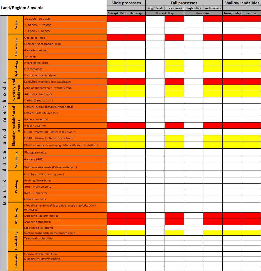
Involvement of the Geological Survey of Slovenia in the field of natural hazard risk management
 Involvement of the Geological Survey of Slovenia in the field of natural hazard risk management Špela Kumelj, Mateja Jemec-Auflič, Jernej Jež, Tina Peternel, Blaž Milanič Geohazard group, GeoZS COMLAND