ECOPEDOLOGICAL SOIL MAP OF THE ALPS PROTOTYPE VERSION 1.0
|
|
|
- Fay Arline Nicholson
- 6 years ago
- Views:
Transcription

1 ECOPEDOLOGICAL SOIL MAP OF THE ALPS PROTOTYPE VERSION 1.0 SCALE 1: Giuseppe Triacchini (CRASL Università Cattolica Brescia) 1
2 Origin of the ECALP project Alpine Convention Protocol on Soil Protection Italy Ministry of the Environment APAT COORDINATION Centro Studi Val d Ossola ARPA Veneto EXCHANGE FORMAT CATHOLIC UNIVERSITY BRESCIA CRASL (Centro di Ricerche per l Ambiente e lo Sviluppo Sostenibile in Lombardia) (Università Cattolica - Brescia) DATABASE SETTING PROTOTYPE MAP ECOPEDOLOGICAL MAP OF THE ALPS - 1: Prototype Version 1.0 2


")
 CDRom")
 Report")

3 The final products 2 folders 293 maps Scale 1: A4 Format (Italian) Final report (Italian) Synthesis (Italian + English) CDRom (Italian + English) Report ECOPEDOLOGICAL MAP OF THE ALPS - 1: Prototype Version 1.0 3

4 ZOOM ECOPEDOLOGICAL MAP OF THE ALPS - 1: Prototype Version 1.0 4
5 The final products HOW THE FINAL PRODUCT AND ITS FORMAT ORIGINATED? The main steps of the ECALP project extracted backward from the details of the maps ECOPEDOLOGICAL MAP OF THE ALPS - 1: Prototype Version 1.0 5
6 Details and elements of each map Logo Title Background theme ECALP Prototype map of the pilot area Scale of representation Location of the pilot area Map ID number Distance bar (km) Colored band ATTRIBUTE of the exchange format represented in the map Legend for basic cartography (boundaries, rivers, ecc) Annotations for reading the map Main Legend (ECALP Theme represented in the map) Reference institution ECOPEDOLOGICAL MAP OF THE ALPS - 1: Prototype Version 1.0 6

7 Details and elements of each map Logo Title Created since the beginning Now it represents the whole project ECOPEDOLOGICAL MAP OF THE ALPS - 1: Prototype Version 1.0 7
 ( Census and acquisition of existing data individuation of pilot areas highly representative of the whole alpine")
8 Data sources for the ECALP maps Background theme ECALP Prototype map of the pilot area based on existing data STEP 1 OF THE ECALP PROJECT: CENSUS OF EXISTING ECO-PEDOLOGICAL INFORMATION ON THE ALPS CENSUS OF THE PRODUCERS OWNERS OF EXISTING ECO-PEDOLOGICAL DATA (beginning 2004) ( Census and acquisition of existing data individuation of pilot areas highly representative of the whole alpine territory and it s characteristics. Individuazione dei contributori del dato, detentori del diritto d uso e accreditati come garanti della meta-informazione ) ECOPEDOLOGICAL MAP OF THE ALPS - 1: Prototype Version 1.0 8

9 AREA OF INVESTIGATION Alpine Territory (Alpine Convention) ECOPEDOLOGICAL MAP OF THE ALPS - 1: Prototype Version 1.0 9
10 Census of existing data Pedological data on the Alpine Territory and accessibility Database European Soil Database 1: Vector European Soil Database 1: Raster Ecopedological Map of Italy 1: (Only Italian side) Structural Atlas of the Alps (SUSTALP) National and local data of the institutions individuated for participating to the ECALP project (different spatial scale) Accessibility Not pubblic. Impossible to acquire Browsable only via SOMIS (JRC) The raster version with cells of 10 km is public and downloadable for free (eusoils.jrc.it) Accessible by agreement with the Italian Ministry of the Environment (based on few and sparse information on the alpine territory) Accessible by agreement with EURAC Maps all based on municipal administrative boundaries a lot of socio-economical and agronomic indicators (added to the CDRom only for completeness) Different situations - HETEROGENEITY ECOPEDOLOGICAL MAP OF THE ALPS - 1: Prototype Version
11 The first ECALP board Collaboration among Centro Studi, Unicatt, JRC, ARPA Veneto Group composed by: -almost 10 people -representatives of the entrusted institutions -Expert and scientists involved during the working progress Several meetings Shared solutions Soil and Waste Unit ECOPEDOLOGICAL MAP OF THE ALPS - 1: Prototype Version

12 Individuation and selection of the international contributors STEP 2 OF THE ECALP PROJECT: Setup and application of the prototype exchange format inside representative pilot areas and definition of the prototype database Proposal of 4 transboundary areas for the individuation of 8 pilot sites: Slovenia Friuli-Venezia Giulia Austria - Veneto Svizzera - Lombardia Francia - Piemonte ECOPEDOLOGICAL MAP OF THE ALPS - 1: Prototype Version
13 Individuation and selection of the international contributors JRC: First meeting inviting the potential ECALP contributors Harmonization of Soil Information in the Alps JRC ISPRA 1-2 July 2004 ECOPEDOLOGICAL MAP OF THE ALPS - 1: Prototype Version

14 Establishment of the ECALP NETWORK The ECALP board: -All the international participants ECOPEDOLOGICAL MAP OF THE ALPS - 1: Prototype Version
15 Details and elements of each map Choice of the pilot areas Proposed by the ECALP international participants Location of the pilot areas Colored band Each pilot area: almost 200 km 2, with boundaries shared by an italian and a foreign participant Distributed on the alpine territory in a signicative way (best representation of the variety of geological and pedoclimatic characteristics) ECOPEDOLOGICAL MAP OF THE ALPS - 1: Prototype Version

16 Each group of maps (single pilot area) has a band with a different color: Name of the pilot area Colored band ECOPEDOLOGICAL MAP OF THE ALPS - 1: Prototype Version
17 HOW TO REPRESENT ECOPEDOLOGICAL INFORMATION? WHICH ECOPEDOLOGICAL ATTRIBUTES? (Setup of the attribute dataset: EXCHANGE FORMAT and METADATA) WHICH FORMAT FOR SPATIAL DATA STRUCTURE? Meetings Shared solutions (Traditional soil map or regular grids?) ECOPEDOLOGICAL MAP OF THE ALPS - 1: Prototype Version


18 HOW TO REPRESENT ECOPEDOLOGICAL INFORMATION? SPATIAL DATA STRUCTURE EXCHANGE FORMAT REGULAR GRID Description of the pixel based on the dominant STU Descriptive parameter of the whole pixel Environmental parameters TABLE OF METADATA INSPIRE (INfrastructure for SPatial InfoRmation in Europe) EUROGRID LAEA ETRS ECOPEDOLOGICAL MAP OF THE ALPS - 1: Prototype Version

19 Details and elements of each map ATTRIBUTE of the exchange format represented in the map ECOPEDOLOGICAL MAP OF THE ALPS - 1: Prototype Version
20 Integration scheme of data available at different scales DEM, admin. boundaries, hydrography Global Land Cover European Soils Database in vector format at the scale of 1: (SOMIS) European Soils Database in raster format at the scale of 1: (SOMIS) Definition of the legends for the European Soils database in raster format PILOT AREA ECOPEDOLOGICAL MAP OF THE ALPS - 1: Prototype Version
 ECOPEDOLOGICAL MAP OF THE ALPS - 1:250.000 - Prototype Version 1.")
21 Conformity of the ECALP legend with those of the Eu Soil DB OVERLAY Legend (Basic layers) Legend (ECALP layer mapped) ECOPEDOLOGICAL MAP OF THE ALPS - 1: Prototype Version

22 Conformity of the ECALP legend with those of the Eu Soil DB Examples of legends reproduced and translated ECOPEDOLOGICAL MAP OF THE ALPS - 1: Prototype Version


23 Conformity of the ECALP legend with those of the Eu Soil DB ECOPEDOLOGICAL MAP OF THE ALPS - 1: Prototype Version
 -Cell of the pilot area: 4 mm 1")
 ECOPEDOLOGICAL MAP OF THE ALPS - 1:250.")
24 Scale of representation Scale of representation Distance bar (km) -Cell of the pilot area: 4 mm 1 km -Mapsheet format A4 (21 x 29.7) ECOPEDOLOGICAL MAP OF THE ALPS - 1: Prototype Version


25 THE DATABASE ECOPEDOLOGICAL MAP OF THE ALPS - 1: Prototype Version

26 COMPLETENESS OF THE DATABASE ECOPEDOLOGICAL MAP OF THE ALPS - 1: Prototype Version
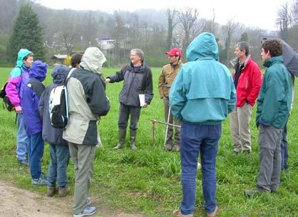
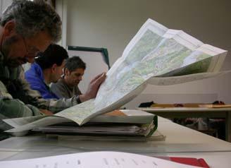
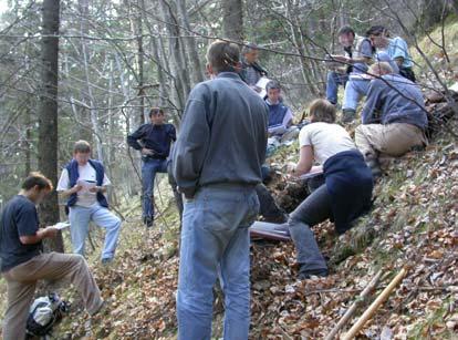
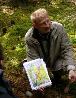
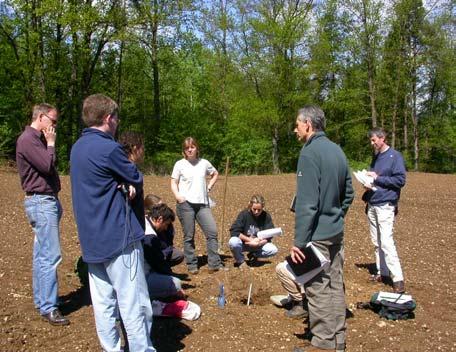
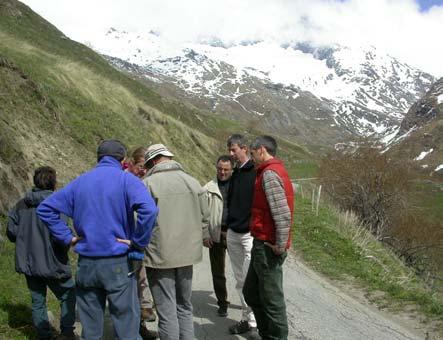
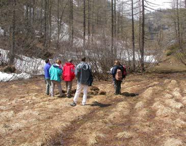
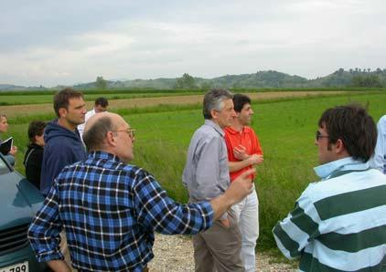
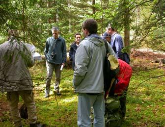
27 EXCURSIONS IN THE PILOT AREAS ECOPEDOLOGICAL MAP OF THE ALPS - 1: Prototype Version

28 EXCURSIONS IN THE PILOT AREAS ECOPEDOLOGICAL MAP OF THE ALPS - 1: Prototype Version
29 DATES OF THE EXCURSIONS IN THE PILOT AREAS ECOPEDOLOGICAL MAP OF THE ALPS - 1: Prototype Version
30 DIFFICULTIES, PROBLEMS AND PROPOSALS OF THE PARTICIPANTS MAIN METHODOLOGICAL ISSUES: SPATIAL SCALE LOSS OF INFORMATION VECTOR VS RASTER (EXPLAINED BY EACH PARTICIPANT) ECOPEDOLOGICAL MAP OF THE ALPS - 1: Prototype Version
31 THANKS FOR YOUR ATTENTION! ECOPEDOLOGICAL MAP OF THE ALPS - 1: Prototype Version
Web Portal to European Soil Database
 Web Portal to European Soil Database A step towards harmonization of Soil Information in Europe Marc Van Liedekerke, Panos Panagos, Jean Dusart Soils Portal: http://eusoils.jrc.it Data The European Soil
GLOBAL SYMPOSIUM ON SOIL ORGANIC CARBON, Rome, Italy, March 2017
 GLOBAL SYMPOSIUM ON SOIL ORGANIC CARBON, Rome, Italy, 21-23 March 2017 Strength and weaknesses of a bottom up approach in estimating soil organic carbon: an experience in the varied Italian scenery I.
Status of implementation of the INSPIRE Directive 2016 Country Fiches. COUNTRY FICHE Italy
 Status of implementation of the INSPIRE Directive 2016 Country Fiches COUNTRY FICHE Italy Introduction... 1 1. State of Play... 2 1.1 Coordination... 2 1.2 Functioning and coordination of the infrastructure...
The Process of Spatial Data Harmonization in Italy. Geom. Paola Ronzino
 The Process of Spatial Data Harmonization in Italy Geom. Paola Ronzino ISSUES Geospatial Information in Europe: lack of data harmonization the lack of data duplication of data CHALLENGES Challenge of INSPIRE:
Italian experience with the interpretation of FOCUS surface water scenarios from a regulatory point of view
 Italian experience with the interpretation of FOCUS surface water scenarios from a regulatory point of view G. Azimonti, G. Triacchini, D. Auteri, E. Redolfi, International Centre for Pesticides and Health
a national geological survey perspective François ROBIDA BRGM (French Geological Survey)
") a national geological survey perspective François ROBIDA BRGM (French Geological Survey) Pre-Conference Seminar on Socio-Economic Value of Geospatial for National and Regional Development 21 August 2017,
a national geological survey perspective François ROBIDA BRGM (French Geological Survey) Pre-Conference Seminar on Socio-Economic Value of Geospatial for National and Regional Development 21 August 2017,
INSPIRE - A Legal framework for environmental and land administration data in Europe
 INSPIRE - A Legal framework for environmental and land administration data in Europe Dr. Markus Seifert Bavarian Administration for Surveying and Cadastre Head of the SDI Office Bavaria Delegate of Germany
Infrastructure for Spatial Information in Europe (INSPIRE)
") Infrastructure for Spatial Information in Europe (INSPIRE) 2011 GISCO Working Party 8-9.3.2012 INSPIRE is about improving access to spatial information: the environment doesn t stop at borders EU Geoportal
Infrastructure for Spatial Information in Europe (INSPIRE) 2011 GISCO Working Party 8-9.3.2012 INSPIRE is about improving access to spatial information: the environment doesn t stop at borders EU Geoportal
INSPIRE Basics. Vlado Cetl European Commission Joint Research Centre. https://ec.europa.eu/jrc/
 INSPIRE Basics Vlado Cetl European Commission Joint Research Centre https://ec.europa.eu/jrc/ Serving society Stimulating innovation Supporting legislation Outline SDI? Why European SDI? INSPIRE Policy
Application of INSPIRE rules to support environmental impact assessment in IPPC(Integrated Pollution Prevention and Control)
") Direzione Ambiente e Difesa del Suolo e della Costa Application of INSPIRE rules to support environmental impact assessment in IPPC(Integrated Pollution Prevention and Control) Inspire Conference Florence
Direzione Ambiente e Difesa del Suolo e della Costa Application of INSPIRE rules to support environmental impact assessment in IPPC(Integrated Pollution Prevention and Control) Inspire Conference Florence
Turkey s National SDI Implementation
 Onur PAŞAOĞULLARI Head of Department Turkey s National SDI Implementation Presentation Plan NSDI Background General Directorate of Geographic Information Systems NSDI Project INSPIRE Directive Urban Information
THE ISONZO SOČA RIVER BASIN
 relator: PhD Geologist Alberto Cisotto e-mail: alberto.cisotto@adbve.it www.adbve.it THE ISONZO SOČA RIVER BASIN Eastern Alps District (NE Italy W Slovenia) Workshop on Transboundary Water Cooperation
I&CLC2000 in support to new policy initiatives (INSPIRE, GMES,..)
") I&CLC2000 in support to new policy initiatives (INSPIRE, GMES,..) Manfred Grasserbauer, Director Joint Research Centre Institute for Environment and Sustainability 1 IMAGE 2000 European mosaic of satellite
I&CLC2000 in support to new policy initiatives (INSPIRE, GMES,..) Manfred Grasserbauer, Director Joint Research Centre Institute for Environment and Sustainability 1 IMAGE 2000 European mosaic of satellite
HARMO-DATA Project Cross border spatial data harmonization using INSPIRE model
 HARMO-DATA Project Cross border spatial data harmonization using INSPIRE model Blaž Barborič, Raffaela Cefalo, Alessandra Chiarandini, Silvano Dezorzi, Tomaž Petek, Martin Puhar, Mauro Zanardo, Tatiana
IRDAT Fvg, evolving a regional Spatial Data Infrastructure according to INSPIRE
 IRDAT Fvg, evolving a regional Spatial Data Infrastructure according to INSPIRE Tutti i diritti riservati. Proprietà INSIEL SpA. A. Benvenuti, A. Chiarandini Insiel (Italy) M. Lunardis - Friuli Venezia
Atlas on spatial structures and processes in the Alps
 Atlas on spatial structures and processes in the Alps Third project meeting in Grenoble on 25 th -27 th of January 2007 Content Overall goals / Addressed persons Basic conditions (financial and time conditions,
SDI in Lombardia (Italy(
 SDI in Lombardia (Italy( Italy) Andrea Piccin European SDI Best Practice Awards 2009 - Learning from Best Practices Turin, 26th and 27th November 2009 Lombardia, in Italy, is 4 th Region for territorial
THE ISONZO SOČA. Workshop on Transboundary Water Cooperation in Central and Western Europe. Eastern Alps District.
 relator: PhD Geologist Alberto Cisotto e-mail: alberto.cisotto@adbve.it www.adbve.it THE ISONZO SOČA RIVER BASIN Eastern Alps District (NE Italy W Slovenia) Workshop on Transboundary Water Cooperation
WP 7: Identification and Selection of Indicators
 WP 7: Identification and Selection of Indicators WP 6 Delphi survey Analysis of relevant political documents Analysis of relevant research projects Documentation of indicators: factsheets Main problem
Vegetation mapping in Italy: an overview
 Vegetation mapping in Italy: an overview G. Bocci, S. Carlesi, P. Bàrberi Institute of Life Sciences - Scuola Superiore Sant Anna Pisa - Italy Problem Italy has a very complex set of climatic and orographic
Status of implementation of the INSPIRE Directive 2016 Country Fiches. COUNTRY FICHE Netherlands
 Status of implementation of the INSPIRE Directive 2016 Country Fiches COUNTRY FICHE Netherlands Introduction... 1 1. State of Play... 2 1.1 Coordination... 2 1.2 Functioning and coordination of the infrastructure...
Sharing soil information with the help of INSPIRE, key challenges with soil data management
 Sharing soil information with the help of INSPIRE, key challenges with soil data management Katharina Feiden e-mail: gssoil@portalu.de GS Soil: project outline GS Soil: Assessment and strategic development
ESBN. Working Group on INSPIRE
 ESBN Working Group on INSPIRE by Marc Van Liedekerke, Endre Dobos and Paul Smits behalf of the WG members WG participants Marc Van Liedekerke Panos Panagos Borut Vrščaj Ivana Kovacikova Erik Obersteiner
ESPON SEMINAR «WHERE ARE EUROPEAN CITIES HEADING? EVIDENCE FOR BETTER POLICY-MAKING» 7-8 DECEMBER BRATISLAVA
 ESPON SEMINAR «WHERE ARE EUROPEAN CITIES HEADING? EVIDENCE FOR BETTER POLICY-MAKING» 7-8 DECEMBER 2016 - BRATISLAVA The Region of Abruzzo: facts & figures Total surface: 1.079.512 Ha; Mountains in Abruzzo
APPLYING THE END FOR LOMBARDY S AIRPORTS
 APPLYING THE END FOR LOMBARDY S AIRPORTS Angela Alberici, Maurizio Bassanino, Paolo Deforza, Nadia Fibbiani, Paola Maggi, Mauro Mussin, Valeria Spirolazzi ARPA Lombardia Via Francesco Restelli 3\1, 20124,
Compact guides GISCO. Geographic information system of the Commission
 Compact guides GISCO Geographic information system of the Commission What is GISCO? GISCO, the Geographic Information System of the COmmission, is a permanent service of Eurostat that fulfils the requirements
A multilevel strategy for tourism development at regional level The case of the Marche Region
 Tourism and Biodiversity in Protected Areas 8th European Charter Network Meeting and Charter Awards (Brussels 6 november 2013) A multilevel strategy for tourism development at regional level The case of
EuroGEOSS for Drought - Linking the European Drought Observatory to global and local scales
 EuroGEOSS for Drought - Linking the European Drought Observatory to global and local scales Barbara Hofer, Stefan Niemeyer, EC-JRC INSPIRE Conference 2010 Cracow June 24, 2010 Drought Relevance Droughts
UN-GGIM: Europe ExCom 1 June 2016 Francfort Work Group A «Core Data» Status and Progress François Chirié, France
 UN-GGIM: Europe ExCom 1 June 2016 Francfort Work Group A «Core Data» Status and Progress François Chirié, France Plan The Core Data Scope Deliverable 7-8 June 2016 WGA workshop to investigate work plans
Newsletter. Nr. 5 / June Special Issue HLanData Pilot Projects
 Nr. 5 / June 2012 Newsletter Special Issue HLanData Pilot Projects Pilot 1: Land Use and Land Cover Data Analysis System for Intermediate-Level Users The main objective of PILOT 1 is to demonstrate the
Status of implementation of the INSPIRE Directive 2016 Country Fiches. COUNTRY FICHE Croatia
 Status of implementation of the INSPIRE Directive 2016 Country Fiches COUNTRY FICHE Croatia Introduction... 1 1. State of Play... 2 1.1 Coordination... 2 1.2 Functioning and coordination of the infrastructure...
INTEROPERABILITY AND SPATIAL PLANNING
 INSPIRE Conference 2011 Edimburgh, July 1st, 2011 INTEROPERABILITY AND SPATIAL PLANNING Franco Vico AMFM GIS Italia Flavio Camerata - DipSU, Università Roma Tre European Network of Best Practices for Interoperability
Minutes Kick Off meeting Spatial Data Services Working Group. Minutes Kick Off meeting Spatial Data Services Working Group Creator
 INSPIRE Infrastructure for Spatial Information in Europe Minutes Kick Off meeting Spatial Data Services Working Group Title Minutes Kick Off meeting Spatial Data Services Working Group Creator European
EuroGeoSurveys An Introduction
 EGS -ASGMI Workshop, Madrid, 2015 EuroGeoSurveys An Introduction 40 Years Listening to the Beat of the Earth Click to edit Master title Albania style EuroGeoSurveys Austria Lithuania Luxembourg Belgium
The state-of-the-art of the Finnish SDI. Arctic SDI WG Meeting
 The state-of-the-art of the Finnish SDI Arctic SDI WG Meeting Moscow 8.9.2011 Esa Tiainen Development Centre 1 NATIONAL LAND SURVEY DOWN TO EARTH Contents Legal framework Coordination structure Network
INSPIRE Directive. Status June 2007
 INSPIRE Directive INfrastructure for SPatial InfoRmation in Europe Status June 2007 European Commission Directorate-General Environment Research, Science and Innovation Unit Rue de la Loi, 200 1049 Brussels
INSPIRE General Introduction & Service Architecture
 INSPIRATION Spatial Data Infrastructure in the Western Balkans INSPIRE General Introduction & Service Architecture 1st National INSPIRATION Workshop Croatia November 21-22, 2012 A multi-countryprojectfunded
Territorial vulnerability analysis: the case studies
 Territorial vulnerability analysis: the case studies M. C. Treu 1, M. Samakovlija 2 & M. Magoni 2 1 DiAP, 2 CEDAT, Politecnico di Milano Abstract This is the second of three papers presented by the Politecnico
Solving the European Data Puzzle Simplifying INSPIRE Challenges and Usage. con terra GmbH Dipl.-Ing. Mark Döring
 Solving the European Data Puzzle Simplifying INSPIRE Challenges and Usage con terra GmbH Dipl.-Ing. Mark Döring INSPIRE Reference Projects GeoBAK 2.0 Project // INSPIRE Data & Services The Project Evolution
SedAlp presentation Lyon, June 22 nd 2015
 SedAlp presentation Lyon, June 22 nd 2015 SedAlp Sediment management in Alpine basins: integrating sediment continuum, risk mitigation and hydropower Introducing the background and project Lyon, June 22
Proposal for a DIRECTIVE OF THE EUROPEAN PARLIAMENT AND OF THE COUNCIL. establishing an infrastructure for spatial information in the Community
 Proposal for a DIRECTIVE OF THE EUROPEAN PARLIAMENT AND OF THE COUNCIL establishing an infrastructure for spatial information in the Community INSPIRE http://inspire.jrc.it/ Alessandro Annoni 1 EU Commission
EuroGeographics & INSPIRE. Nick Land, Executive Director of EuroGeographics
 EuroGeographics & INSPIRE Nick Land, Executive Director of EuroGeographics EuroGeographics A growing association 49 Members, 42 countries Topographic mapping, cadastre, land registry + Networked organisation
Adding value to Copernicus services with member states reference data
 www.eurogeographics.org Adding value to Copernicus services with member states reference data Neil Sutherland neil.sutherland@os.uk GIS in the EU 10 November 2016 Copyright 2016 EuroGeographics 61 member
Landslide susceptibility assessment over Europe according to the Tier 1 approach: Experiment and perspectives
 Landslide susceptibility assessment over Europe according to the Tier 1 approach: Experiment and perspectives Andreas Günther 1 & Paola Reichenbach 2 1 Bundesanstalt für Geowissenschaften und Rohstoffe
Project based approach developing National Spatial Data Infrastructure in Lithuania
 Project based approach developing National Spatial Data Infrastructure in Lithuania National Land Service under the Ministry of Agriculture of The Republic of Lithuania Cadastres & Geodesy Department Director
Measuring and Monitoring SDGs in Portugal: Ratio of land consumption rate to population growth rate Mountain Green Cover Index
 Measuring and Monitoring SDGs in Portugal: 11.3.1Ratio of land consumption rate to population growth rate 15.4.2 Mountain Green Cover Index United Nations World Geospatial Information Congress João David
SITMUN: Cooperating to Build Local SDIs in the Barcelona Region
 SITMUN: Cooperating to Build Local SDIs in the Barcelona Region Diputació de Barcelona Territory and Sustainability Area Territorial Information Systems Department INSPIRE CONFERENCE Barcelona, September
Status of implementation of the INSPIRE Directive 2016 Country Fiches. COUNTRY FICHE Portugal
 Status of implementation of the INSPIRE Directive 2016 Country Fiches COUNTRY FICHE Portugal Introduction... 1 1. State of Play... 2 1.1 Coordination... 2 1.2 Functioning and coordination of the infrastructure...
Gistat: moving towards a location information management system
 Gistat: moving towards a location information management system (merging geographical, statistical and historical information) Pina Grazia Ticca Marco Ballin Istat - Italy Aguascalientes, Mexico 2-4 December
LUCAS Technical reference document U1 LUCAS Survey data user guide. (Land Use / Cover Area Frame Survey)
") Regional statistics and Geographic Information Author: E4.LUCAS (ESTAT) TechnicalDocuments 2015 LUCAS 2015 (Land Use / Cover Area Frame Survey) Technical reference document U1 LUCAS Survey data user guide
Regional statistics and Geographic Information Author: E4.LUCAS (ESTAT) TechnicalDocuments 2015 LUCAS 2015 (Land Use / Cover Area Frame Survey) Technical reference document U1 LUCAS Survey data user guide
Statistical-geospatial integration - The example of Sweden. Marie Haldorson Director, Statistics Sweden
 Statistical-geospatial integration - The example of Sweden Marie Haldorson Director, Statistics Sweden Spatial data and geospatial applications at Statistics Sweden Long tradition GI integrated in production
THE 3-REGIONS WORKING GROUP SLOPE INSTABILITIES (SlopeIn)
") Bayerisches Landesamt für Umwelt THE 3-REGIONS WORKING GROUP SLOPE INSTABILITIES (SlopeIn) COMMON LANGUAGE, COMPARABLE HAZARD MAPPING AND SHARED EXPERIENCES ACROSS EUROPE The 3-Regions Working-Group SlopeIn:
Bayerisches Landesamt für Umwelt THE 3-REGIONS WORKING GROUP SLOPE INSTABILITIES (SlopeIn) COMMON LANGUAGE, COMPARABLE HAZARD MAPPING AND SHARED EXPERIENCES ACROSS EUROPE The 3-Regions Working-Group SlopeIn:
GIS4EU and Operational Validation of the INSPIRE Common Data Models
 image012.jpg Provision of interoperable datasets to open GI to EU communities Tools an Experiences in Implementing INSPIRE Data Specification II: GIS4EU and Operational Validation of the INSPIRE Common
econtentplus GS Soil
 econtentplus GS Soil General aims Assessment and strategic development of INSPIRE compliant Geodata-Services for European Soil Data BPN on basis of the EU 2007/2/EC (INSPIRE) Directive for Annex III theme
INSPIREd solutions for Air Quality problems Alexander Kotsev
 INSPIREd solutions for Air Quality problems Alexander Kotsev www.jrc.ec.europa.eu Serving society Stimulating innovation Supporting legislation The European data puzzle The European data puzzle 24 official
Norwegian spatial data infrastructure supporting disaster risk management Norwegian Mapping Authority
 Norwegian spatial data infrastructure supporting disaster risk management Norwegian Mapping Authority Arvid Lillethun, Norwegian Mapping Authority Land and Poverty 2018 Conference, World Bank 19.-23. March
Status of implementation of the INSPIRE Directive 2016 Country Fiches. COUNTRY FICHE Czech Republic
 Status of implementation of the INSPIRE Directive 2016 Country Fiches COUNTRY FICHE Czech Republic Introduction... 1 1. State of Play... 2 1.1 Coordination... 2 1.2 Functioning and coordination of the
Ministry of ICT of I.R.IRAN
 The ECO 8/6 mill km 2 10 Slamic countries ~330 mill people Oil, Gas, Industries,Tourism 2 Issue transformation in last decade Problem solving needs more integrated approach More interaction &complexity
INSPIRE and CityGML Energy ADE An example from CitiEnGov project
 Delft (NL) 6 th December 2018 INSPIRE and CityGML Energy ADE An example from CitiEnGov project CitiEnGov Dedagroup Public Services Piergiorgio Cipriano WHO I AM AND WHY I AM HERE TAKING COOPERATION FORWARD
RESOURCES DEVELOPMENT GEOSPATIAL DATA USING THE DIGITAL TOPOGRAPHIC PLAN OF ROMANIA- TOPRO5
 C. C-tin Muşat, F. M. Brebu, A. C. Bălă, I. S. Herban Resources Development Digital Geospatial Data Using the Digital Topographic Plan of Romania - TOPRO5 RESOURCES DEVELOPMENT GEOSPATIAL DATA USING THE
Status of the European Indoor Radon Map
 Status of the European Indoor Radon Map Tore Tollefsen 1, Marc De Cort 1, Peter Bossew 2 1 Joint Research Centre Institute for Environment and Sustainability Radioactivity Environmental Monitoring (REM)
The European Commission s science and knowledge service. Joint Research Centre
 The European Commission s science and knowledge service Joint Research Centre Analysis of the European Atlas of Natural Radiation data within geological and soil units Giorgia Cinelli 1, Peter Bossew 2,
The road to national Inspire-compliant datasets in the Czech republic
 The road to national Inspire-compliant datasets in the Czech republic Ing. Pavel Šidlichovský (Land Survey Office of Czech Republic) INSPIRE 2014; 18.6. Aalborg Overview Directive transposition COSMC and
From the Venice Lagoon Atlas towards a collaborative federated system
 From the Venice Lagoon Atlas towards a collaborative federated system City of Venice Alessandro Mulazzani CORILA Consortium for Coordination of Research Activities Concerning the Venice Lagoon System ISMAR-CNR
Plan4all (econtentplus project)
") Plan4all (econtentplus project) Karel CHARVAT 1, Tomáš MILDORF 2 1 Help service remote sensing, Ltd., Černoleská 1600, 256 01 Benešov u Prahy, Czech Republic charvat@bnhelp.cz 2 Department of Mathematics
Plan4all (econtentplus project) Karel CHARVAT 1, Tomáš MILDORF 2 1 Help service remote sensing, Ltd., Černoleská 1600, 256 01 Benešov u Prahy, Czech Republic charvat@bnhelp.cz 2 Department of Mathematics
Least-Cost Transportation Corridor Analysis Using Raster Data.
 Least-Cost Transportation Corridor Analysis Using Raster Data What is GeoMedia Grid: Key Grid Concepts Vector Model Vector based systems show data by means of a series of points, lines, and polygons. Each
Spatially enabling e-government through geo-services
 Spatially enabling e-government through geo-services Mauro Salvemini EUROGI PRESIDENT Professor at Sapienza Università di Roma (IT) 1 About the presentation Few information about Eurogi ; Some essential
The Infrastructure for Spatial Information in the European Community vs. regional SDI: the shortest way for reaching economic and social development
 The Infrastructure for Spatial Information in the European Community vs. regional SDI: the shortest way for reaching economic and social development Mauro Salvemini EUROGI PRESIDENT Professor at Sapienza
Status of implementation of the INSPIRE Directive 2016 Country Fiches. COUNTRY FICHE Malta
 Status of implementation of the INSPIRE Directive 2016 Country Fiches COUNTRY FICHE Malta Introduction... 1 1. State of Play... 2 1.1 Coordination... 2 1.2 Functioning and coordination of the infrastructure...
Establishing a high-resolution precipitation dataset for the Alps
 Federal Department of Home Affairs FDHA Federal Office of Meteorology and Climatology MeteoSwiss Establishing a high-resolution precipitation dataset for the Alps F. A. Isotta, C. Lukasczyk, and C. Frei
The story of sharing environmental data
 The story of sharing environmental data Kallio, Pyhälahti, Harju, Teiniranta, Lahtinen, Finnish Environment Institute SYKE OKFestival, Finnish Open Data, 18. Sep 2012 Contents Call for environmental knowledge
Haydar Hussin (1), Roxana Ciurean (2), Paola Reichenbach (1), Cees van Westen (3), Gianluca Marcato (4), Simone Frigerio (4), V. Juliette Cortes (4)
, Roxana Ciurean (2), Paola Reichenbach (1), Cees van Westen (3), Gianluca Marcato (4), Simone Frigerio (4), V. Juliette Cortes (4)") 7/10/2013 Changing Hydro-meteorological Risks - as Analyzed by a New Generation of European Scientists Probabilistic 2D numerical landslide modeling: a first step towards assessing changes in risk due
7/10/2013 Changing Hydro-meteorological Risks - as Analyzed by a New Generation of European Scientists Probabilistic 2D numerical landslide modeling: a first step towards assessing changes in risk due
Coastal data for Integrated Maritime Policies
 Coastal data for Integrated Maritime Policies LOCHET Corine Shom Name of presentation Protection against erosion and marine flood Name presenter Link between different data scales and Name of presentation
GIS Solutions in Natural Resource Management: Balancing the Technical- Political Equation
 GIS Solutions in Natural Resource Management: Balancing the Technical- Political Equation Stan Morain, Editor SUB Gdttlngen 7 208 520 309 98 A14447 0NW0RD PRESS V? % \
European Forum for Geography and Statistics Vienna Conference Vienna, November 2015 Name (s) of author(s) IT Geostat Population Grid 2011
 of author(s) IT Geostat Population Grid 2011") European Forum for Geography and Statistics Vienna Conference Vienna, 10 12 November 2015 Name (s) of author(s) (1) Raffaella Chiocchini (1) Stefano Mugnoli (2) Luca Congedo (2) Michele Munafò Organization
European Forum for Geography and Statistics Vienna Conference Vienna, 10 12 November 2015 Name (s) of author(s) (1) Raffaella Chiocchini (1) Stefano Mugnoli (2) Luca Congedo (2) Michele Munafò Organization
Progress of UN-GGIM: Europe Working Group A on Core Data
 PolicyKEN Budapest 29 November 2016 Progress of UN-GGIM: Europe Working Group A on Core Data François Chirié, Dominique Laurent, IGNF Core data context Background and purpose Aim of Work Group A to propose
Two case history of EMS data application: earthquake in central italy and flooding in Piedmont region
 Two case history of EMS data application: earthquake in central italy and flooding in Piedmont region Luca Lanteri*, Rocco Pispico*, R. Cremonini** *Arpa Piemonte, Geological and Natural Risk Dipartiment
INSPIRE implementation in the Turkish Ministry of Environment and Urbanization Producing and Publishing Environmental Data
 INSPIRE implementation in the Turkish Ministry of Environment and Urbanization Producing and Publishing Environmental Data Ezgi Sarmusak Urban Planner, MoEU Sibel Süer Toybıyık - Assistant Expert, MoEU
New Prospects for Peripheral Rural Regions Helmut Hiess Glasgow, 19th of May 2010
 New Prospects for Peripheral Rural Regions Helmut Hiess Glasgow, 19th of May 2010 ÖROK: Organisation & Tasks Austrian Conference on Spatial Planning (ÖROK, since 1971): Joint organisation by Federal level,
How local communities could profit from Habitats infrastructure
 Social Validation of INSPIRE Annex III Data Structures in EU Habitats How local communities could profit from Habitats infrastructure Andrea Scianna ( Icar CNR Italy ) consultant for Madonie Park Authority
INSPIRE in Sweden.
 INSPIRE in Sweden Swedish National Data Service Established 2008. SND is a service organisation for Swedish research within the Humanities, Social Sciences and Medicine. SND is the Swedish node in an international
State of the Art. in Spatial Planning Data Harmonisation & Spatial Data Infrastructure (SDI) Julia Neuschmid, CEIT ALANOVA
 Julia Neuschmid, CEIT ALANOVA") INSPIRE Conference, June 2010, Krakow State of the Art in Spatial Planning Data Harmonisation & Spatial Data Infrastructure (SDI) Julia Neuschmid, CEIT ALANOVA Co-funded by the Community programme econtentplus
INSPIRE Conference, June 2010, Krakow State of the Art in Spatial Planning Data Harmonisation & Spatial Data Infrastructure (SDI) Julia Neuschmid, CEIT ALANOVA Co-funded by the Community programme econtentplus
Combination of high resolution satellite images population census statistics to estimating population exposed to risks of disaster
 Combination of high resolution satellite images population census statistics to estimating population exposed to risks of disaster Daniel Clarke (UNESCAP) Jean-Louis Weber (Consultant-UNESCAP) Disaster
CHILEAN GEO-SPATIAL NATIONAL DATA INFRASTRUCTURE (INDE) Pablo Gran Rodrigo Barriga Alfredo Gonzalez María L. Advis Juan C. Montero Leonardo Oyarzun
 Pablo Gran Rodrigo Barriga Alfredo Gonzalez María L. Advis Juan C. Montero Leonardo Oyarzun") CHILEAN GEO-SPATIAL NATIONAL INFRASTRUCTURE (INDE) Pablo Gran Rodrigo Barriga Alfredo Gonzalez María L. Advis Juan C. Montero Leonardo Oyarzun ABSTRACT The present paper summarizes a joint effort undertaken
CHILEAN GEO-SPATIAL NATIONAL INFRASTRUCTURE (INDE) Pablo Gran Rodrigo Barriga Alfredo Gonzalez María L. Advis Juan C. Montero Leonardo Oyarzun ABSTRACT The present paper summarizes a joint effort undertaken
Pal NIKOLLI Bashkim IDRIZI Ismail KABASHI Adelajda HALILI THE IMPLEMENTATION OF NATIONAL SPATIAL DATA INFRASTRUCTURE IN ALBANIA
 Pal NIKOLLI Bashkim IDRIZI Ismail KABASHI Adelajda HALILI THE IMPLEMENTATION OF NATIONAL SPATIAL DATA INFRASTRUCTURE IN ALBANIA Overview: Goals of paper Some definitions of SDI NSDI Development NSDI in
GIS Geographical Information Systems. GIS Management
 GIS Geographical Information Systems GIS Management Difficulties on establishing a GIS Funding GIS Determining Project Standards Data Gathering Map Development Recruiting GIS Professionals Educating Staff
Report on the establishment of UN GGIM: Europe Item 14. 4th session of the Committee of Experts on UN-GGIM
 Report on the establishment of UN GGIM: Europe Item 14 1 Why regional European committees of UN GGIM? In the ECOSOC resolution 2011/24 on the UN GGIM: Emphasizes the importance of promoting national, regional
CentropeSTATISTICS Working Interactively with Cross-Border Statistic Data Clemens Beyer, Walter Pozarek, Manfred Schrenk
 Clemens Beyer, Walter Pozarek, Manfred Schrenk (Dipl.-Ing. Clemens Beyer, CEIT ALANOVA, Concorde Business Park 2/F, 2320 Schwechat, Austria, c.beyer@ceit.at) (Dipl.-Ing. Walter Pozarek, PGO Planungsgemeinschaft
The IHPT Marine Spatial Data infrastructure and its contribution to the INSPIRE Directive
 The IHPT Marine Spatial Data infrastructure and its contribution to the INSPIRE Directive INSPIRE - GWF 2015 - Coastal & Marine session Lisbon Congress Center, Portugal - Thursday, 28 May 2015 Summary
Land Cover and Land use in Environment Statistics
 UNITED NATIONS STATISTICS DIVISION (UNSD) Workshop on Environment Statistics in support of the implementation of the Framework for the Development of Environment Statistics (FDES 2013) Balaclava, Mauritius
VENETO REGION PILOT AREA
 VENETO REGION PILOT AREA The pilot area is located in the north-east of Veneto region, located itself in the north-east of Italy. The area borders with Austria are in the northern part and run along high
Gis for Land Management: An Overview on Italy
 Gis for Land Management: An Overview on Italy Paola RONZINO, Italy Key words: Cartography, Land Management, Spatial Planning, Urban Renewal, Spatial Information, Environment SUMMARY The introduction of
FLORA: FLood estimation and forecast in complex Orographic areas for Risk mitigation in the Alpine space
 Natural Risk Management in a changing climate: Experiences in Adaptation Strategies from some European Projekts Milano - December 14 th, 2011 FLORA: FLood estimation and forecast in complex Orographic
INSPIRE Monitoring and Reporting Implementing Rule Draft v2.1
 INSPIRE Infrastructure for Spatial Information in Europe INSPIRE Monitoring and Reporting Implementing Rule Draft v2.1 Title INSPIRE Monitoring and Reporting Implementing Rule v2.1 Creator DT Monitoring
Generalized map production: Italian experiences
 Generalized map production: Italian experiences FIG Working Week 2012 Knowing to manage the territory, protect the environment, evaluate the cultural heritage Rome, Italy, 6-10 May 2012 Gabriele GARNERO,
Experimental Ecology and Geobotany A rapid methodology for the survey of Floristic Cartography quadrants in the Po Plain (North-Italy)
") Scientifica Acta 2, No. 2, 55 59 (2008) Experimental Ecology and Geobotany A rapid methodology for the survey of Floristic Cartography quadrants in the Po Plain (North-Italy) Augusta Carrea Dipartimento
Scientifica Acta 2, No. 2, 55 59 (2008) Experimental Ecology and Geobotany A rapid methodology for the survey of Floristic Cartography quadrants in the Po Plain (North-Italy) Augusta Carrea Dipartimento
Annex 4. Mapping Accessibility Protocol
 Annex 4. Mapping Accessibility Protocol Protocol for mapping accessibility to show travel time required to transport agricultural commodities in the Southwest Region, Cameroon 1.1 Introduction Accessibility
A donor partner view. Olaf Magnus Østensen. 'Modernization of spatial data infrastructure to reduce risks and impacts of floods'
 A donor partner view Olaf Magnus Østensen 'Modernization of spatial data infrastructure to reduce risks and impacts of floods' About the EEA Grants programme http://eeagrants.org/ Beneficiary country Donor
Upgrade the Datasets in NSDI for Smarter Services with the Cases of China
 Upgrade the Datasets in NSDI for Smarter Services with the Cases of China By Dr. JIANG Jie Dept of GeoInformaiton Service Platform National Geomatics Center of China October 7, 2015 Jeju, Republic of Korea
CEMAT results - over the years
 CEMAT results - over the years Technical Conference on Functional Areas capitalization of local potential within the territorial development policies in Europe European Conference of Ministers responsible