Land Cover and Land use in Environment Statistics
|
|
|
- Shonda Pierce
- 6 years ago
- Views:
Transcription


1 UNITED NATIONS STATISTICS DIVISION (UNSD) Workshop on Environment Statistics in support of the implementation of the Framework for the Development of Environment Statistics (FDES 2013) Balaclava, Mauritius January 2015 Land Cover and Land use in Environment Statistics

2 Contents Introduction Definitions Land Cover Classifications Sources of global and regional land cover for environment statistics and indicators series Methodological Guidance for countries Tools and Softwares - GIS data Uses and dissemination Demos


3 Introduction Statistics on land use fulfil a basic informational need of governments, policy makers, analysts and civil society. Land is a unique environmental resource that delineates the space in which economic activities and environmental processes take place and within which environmental resources and economic assets are located. The two primary aspects of land are land cover (see Topic Land cover in FDES 2013) and land use (see Topic Land use in FDES 2013). These aspects are strictly related: while land cover describes the biophysical aspect of land, land use refers to the functional aspects of land. Changes in land cover can be the result of natural processes and of land use changes. Generally, the total area of a country will remain unchanged from one period to the next. Hence, changes in the stocks of land will comprise changes within and between stocks in different classes of land cover and land use (land restructuring) [FDES 2013].
4 Definitions Land cover is defined by FAO as, the observed (bio) physical cover on the earth's surface. (FAO, 2005) Changes in land cover are the result of natural processes and changes in land use. The total area of a country is the area enclosed by its inland borders and, if applicable, the sea. While inland waters (e.g., rivers, lakes, ponds etc.), are included in land use, marine water areas can be included only in a broader concept of land use. Certain types of land use analyses may include coastal waters (internal waters) or even Exclusive Economic Zones (EEZs) [FDES 2013].
5 Definitions Land cover assessments can be carried out from continental, through regional, national to sub-national levels. These location based classifications can be useful for specific purposes, such as ecosystem management or watershed management. At continental scales, map products aim to monitor land cover - the observed physical cover on the surface of the Earth - and its change over time. These maps can be based on Moderate Resolution Imaging Spectroradiometer (MODIS) satellite imagery monthly composites at 250 m spatial resolution. The Nineteen land cover classes defined by the LCCS standard can be used. These sub continental scale maps can depict information about land cover and land cover change in a seamless, consistent, and automated way across at regular intervals. The technical aspects of geospatial information, including remote sensing data, can be dealt with experts in the domain. Section 1.8 of the FDES 2013 provides an overview of geospatial information and environment statistics.
6 Coverage -Temporal and spatial considerations Spatial consideration occurrence and impacts of environmental phenomena are distributed through space without regard for political-administrative boundaries. The most meaningful spatial units for environment statistics are natural units, such as watersheds, ecosystems, eco-zones, landscape or land cover units; or management and planning units based on the natural units, such as protected areas, coastal areas or river basin districts.
.")
7 The aim of the classification is to provide a common framework to compile and aggregate land cover information available at the national level and make it comparable at the international level, and to provide a structure to guide data collection and the creation of land cover databases for countries in the process of establishing a land cover statistics domain (FDES 2013). Classification
 has been developed by the FAO.")
8 Classifications Land cover can be classified into different classes and each country can customise the classes to meet their own needs. An international standard is not yet adopted but a Land Cover Classification System (LCCS) has been developed by the FAO. The large numbers of combinations of land cover features that can be created using the LCCS approach apply to any type of land cover. Moreover, after a comprehensive global consultation process, a classification composed of 14 classes has been developed in the SEEA Central Framework. These 14 classes have been generated using the LCCS approach and thus provide a comprehensive set of land cover types, mutually exclusive and unambiguous, with clear boundaries and systematic definitions. Furthermore, the identified classes are defined to be used as the basis for the development of ecosystem statistics.
9 Classification Land cover can be classified according to location and area. Type of land cover can be: artificial surfaces including urban and associated areas; herbaceous crops; woody crops; multiple or layered crops; grassland; tree covered areas; mangroves; shrub covered areas; shrubs and/or herbaceous vegetation, aquatic or regularly flooded; sparsely natural vegetated areas; terrestrial barren land; permanent snow and glaciers; inland water bodies; and coastal water bodies and intertidal areas
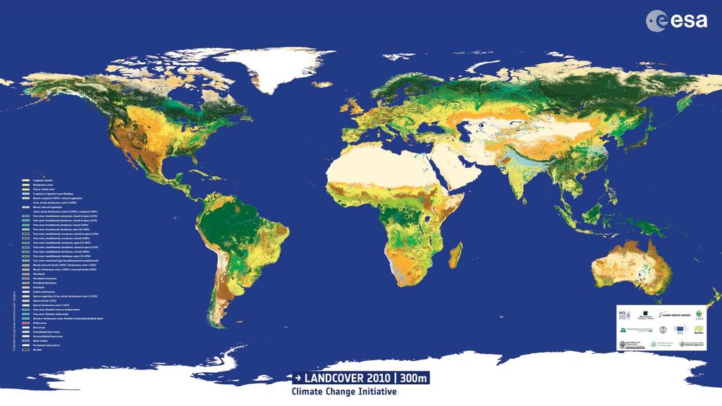
10 World Land Cover
11 International sources and recommendations International organizations have produced guidance documents for the collection of land cover data, e.g. for the monitoring of policy targets and/or implementation of legislation and international conventions: (non exhaustive list): FAO LCCS: It aims to provide improved access to reliable and standardized information on land cover and land cover change. It is a comprehensive, standardized a priori classification system designed to meet specific user requirements, and created for mapping exercises, independent of the scale or means used to map. IPCC LULUCF and AFOLU classes: Good Practice Guidance for Land Use, Land-Use Change and Forestry ( and 2006 IPCC Guidelines for National Greenhouse Gas Inventories, Volume 4, Agriculture, Forestry and Other Land Use ( UN SEEA: The System of Environment economic Accounting (SEEA) Central Framework ( and the SEEA Experimental Ecosystem accounts ( ) both include some information on land cover.
12 International sources and recommendations (continued) CBD ENCA QSP: The Convention on Biodiversity (CBD) prepared the ECOSYSTEM NATURAL CAPITAL ACCOUNTS: A QUICK START PACKAGE For implementing Aichi Biodiversity Target 2 on Integration of Biodiversity Values in National Accounting Systems in the context of the SEEA ( North American Land Change Monitoring System (NALCMS). NALCMS is a collaborative initiative between Canada, Mexico, and the United States to monitor land cover and its change over time. EU: CORINE Land cover: In 1985 the Corine programme was initiated in the European Union. Corine means 'coordination of information on the environment'. The Corine databases and several of its programmes includes an inventory of land cover in 44 classes, and presented as a cartographic product, at a scale of 1: This database is operationally available for most areas of Europe. European Communities, 2001: Manual of concepts on land cover and land use information systems ( -I- EN.pdf#page=10)

13 Geospatial information Geospatial information presents the location and characteristics of different attributes of the atmosphere, surface and sub-surface. It is used to describe, display and analyze data that have discernible spatial aspects, such as land use, water resources and natural disasters. Geospatial information allows for the visual display of different statistics in a map-based layout, which can make it easier for users to work with and understand the data.

14 Geospatial information The complexity of current environmental issues (e.g., climate change, biodiversity loss, ecosystem health, natural disaster frequency and intensity, population growth, food and water shortages, etc.) increasingly calls for the integration of geospatial information, statistics and sectoral data for more effective and efficient monitoring of progress in the environmental pillar of sustainable development. Geographic Information Systems (GIS) can help establish the links between different types and layers of data by providing powerful tools for storage and analysis of spatial data and by integrating databases from different sectors in the same format and structure.
15 Geospatial information A GIS is a computer system capable of capturing, storing, analyzing, and displaying geographically referenced information. Geospatial data can be acquired using a variety of technologies such as Global Positioning System (GPS) and Remote Sensing satellites. Land surveyors, census takers, aerial photographers, police, and even average citizens with a GPS enabled cell phone can collect geospatial data using GPS or street addresses that can be entered into GIS. The attributes of the collected data, such as land-use information, demographics, landscape features, or crime scene observations, can be entered manually or, in the case of a land survey map, digitized from a map format to a digital format by electronic scanning.


16 Sources of global and regional land cover for environment statistics and indicators series


17 Spatial Integration of Environmental & Socio-Economic Data Collection Mapping Socio-Economic Statistics Land cover continuous mapping as well as censuses, registers or exhaustive surveys: main features & spatial distribution Earth Observation Sampling detailed information representative for an area, a type, a group Individual Sites Monitoring Complete investigation of important or rare ecosystems, protected areas, case studies, long term ecological monitoring
 Integration, analysis and reporting")

18 Main data flows to compile Land use statistics Data input Data assimilation (1 km2 grid) Integration, analysis and reporting Socioeconomic statistics by regions Disaggregat e& map Monitoring data. rasters Aggregate & map Monitoring data, samples Extrapolate Standard coefficients Multiply
19 Data - Sources of global and regional land cover for environment statistics and indicators series There are several international organisations that collect data on land cover and data from which land cover can be assessed. Many of these are remote sensing data. Below is a list of these data sources (non exhaustive): U.S Geological Survey (USGS) Land Cover Institute (LCI) ( A list of land cover data can be found on the LCI website, for every continent and for various uses such climate, fires, eco-regions etc. Global Land Cover Network (GLCN) ( provides global information on land cover and its dynamics, harmonizing land cover mapping and monitoring at national, regional and global levels. The GLCF is a center for land cover science with a focus on research using remotely sensed satellite data and products to access land cover change for local to global systems. (
20 Data - Sources of global and regional land cover for environment statistics and indicators series (continued) EU Eurostat: Land cover and land use statistics at regional level ( over_and_land_use_statistics_at_regional_level) provides regional data in Africover: This is part of the Global Land Cover Network (GLCN) ( The Africover project, on which the GLCN programme has built its success, was established to develop a digital georeferenced database on land cover and a geographic referential for the whole of Africa including geodetical homogeneous referential, toponomy, roads and hydrography. Methodologies, operational procedures and software tools for the land cover analysis in the Africover program have been developed through the Africover Eastern Africa module under the financing of the Italian Cooperation. The University of Maryland produces forest change data for the whole world. These can be freely accessed for any country and region. Results are available for time-series analysis of 654,178 Landsat 7 ETM+ images in characterizing global forest extent and change from 2000 through Web-based visualizations of these results are also available at and
21 Data - Sources of global and regional land cover for environment statistics and indicators series North American Land Change Monitoring System (NALCMS). NALCMS is a collaborative initiative between Canada, Mexico, and the United States to monitor land cover and its change over time. EU: CORINE Land cover: In 1985 the Corine programme was initiated in the European Union. Corine means 'coordination of information on the environment'. LUCAS is the acronym of Land Use and Cover Area frame Survey. The aim of the LUCAS survey is to gather harmonised information on land use and land cover. The survey also provides territorial information facilitating the analysis of the interactions between agriculture, environment and countryside, such as irrigation and land management. Since 2006, EUROSTAT has carried out LUCAS surveys every three years ( C-CAP Land Cover Atlas: This online data viewer provides user-friendly access to regional land cover and land cover change information developed through NOAA s Coastal Change Analysis Program (C-CAP). The Land Cover Atlas eliminates the need for desktop geographic information system software, or advanced technical expertise, by processing C-CAP data for the user and providing easy access to that distilled information. The tool summarizes general change trends (such as forest losses or new development) and can highlight specific changes of interest (salt marsh losses to open water, or evergreen forest losses to development, for instance).
22 Data collection Land cover data are normally managed by specialized agencies which work on GIS and land administrations etc. Other agencies, such as those responsible for forestry, water or agriculture may keep good databases on land cover. Geographically referenced information that includes digital maps, satellite and aerial imagery, and other sources of data that are linked to a location or a map feature, all structured in databases, will also add significantly to the quantity and quality of information that is organized within the context of environment statistics. GIS can be viewed as an integrating technology that helps to capture, manage, analyze, distribute and use a wide range of data with a spatial or locational component (FDES 2013).
23 Data compilation (procedures and instruments) and transformation into environment statistics series Remote sensing data normally deals with pixel of information. The value for the pixel may indicate the change in classification, e.g between 2005 and Codes can also be used within pixels. For instance, values other than 0 are either three or four digits. The first digit or the first two digits for a 4-digit Value, indicate the 2005 classification for the area whereas the last two digits indicate the 2010 values
24 Remote sensing Remote sensing data from satellites are acquired digitally and communicated to central facilities for processing and analysis in GIS. Digital satellite images, for example, can be analyzed in GIS to produce maps of land cover and land use. When different types of geospatial data are combined in GIS (e.g., through combining satellite remote sensing land use information with aerial photographic data on housing development growth), the data must be transformed so they fit the same coordinates. GIS uses the processing power of a computer, together with geographic mapping techniques (cartography), to transform data from different sources onto one projection and one scale so that the data can be analyzed together
25
26 Remote sensing Remote sensing is a technique for gathering information about an object without coming into physical contact with it. It is the quantitative analysis of digital information where measurements can be made from ground, aircrafts or satellites. The information is carried by electromagnetic radiation. With remote sensing, skills are needed in digital image analysis where computer programming, image display tools and statistics, etc., are required for interdisciplinary work that might involve scientists and experts in various fields - biology, climatology, geology, atmospheric science, chemistry, oceanography, and more. With satellite remote sensing, global issues can be addressed by monitoring regional and global changes Source: Government Accountability Office, (2004), Geospatial Information: Better Coordination Needed to Identify and Reduce Duplicative Investments,
27 Methods and Concepts The statistical population comprises all land cover categories at national, sub-national, regional and/or river basin level or any national delineation. It also includes all public and private land for economic activities, land under municipalities including households and settlements. The statistical unit is a unit of observation or measurement for which data are collected or derived. The statistical unit is therefore the basic element for compiling and tabulating statistical data. The statistical units of the environment are the parts of the environment about which information is collected and statistics are compiled. For land cover, the term Basic Spatial Unit (BSU) has been used in the SEEA. In the CBD QSP (see section 3B above), the BSU has been taken as a grid of 1 ha and 1 km2 (large areas, e.g Europe) and 10 m x 10 m and 1 ha for small areas (e.g Mauritius). Reporting unit: The reporting unit is the unit of the economy that reports information about the statistical unit. For example, a lake can be a statistical unit but any information about the lake will have to be reported by a unit of the economy that owns, manages or monitors the lake or any part thereof. Reporting units are public and private enterprises and establishments, or parts of thereof, and municipalities that owns and/or use the land
28 Methods and Concepts (continued) Measurement unit: Land cover and land use are expressed in square kilometers (Km 2 ) and percentage (%). For landscape indicators, relative % frequencies are given. The hectare (Ha) is also often used for land cover measurement. Validation: The validation of the data may require specialized skills, e.g remote sensing. Checking can involve seeing whether data are o compliant with standards; without formal errors; without obvious content errors, Comparing with previous data (where available), checking transect; checking GPS tracks; checking the quality of the photos and anonymizing them where needed. Sampling and non sampling errors may also need to be assessed. Metadata: Metadata is a set of data that describes and gives information about other data. Metadata forms an important item in land cover data, particularly because it involves remote sensing and GIS. For the description of the statistics produced it is recommended to use agreed meta-data formats for statistics. A widely used format is the SDMX metadata format.
29 Tools and Softwares for land data Tools and Softwares can be easily available for compiling or producing land cover statistics. Use of these tools may require from basic to advanced trainings in GIS and remote sensing. Some tools and softwares freely available are: LCCS: The software is freely distributed by FAO through a self-extracting executable file that produces the entire set of files necessary to run the setup. The LCCS software contains four modules and tools: - Classification; -Legend; Link and Translator. QGIS: A Free and Open Source Geographic Information System. QGIS has a lot of documentation and is a user-friendly GIS, providing common functions and features. GeoVis: Provides a list of software tools for land cover data. The LCCS is also include in this tool.
30 Presentation/Disseminations formats Tabular: Land cover statistics can be presented in tables, by country or region, by river basin (catchment area), by economic activity of the land user and/or land owner, and by land type (residential/commercial/industrial). Indicators could be presented per capita or related to economic output of the land cover activity. Land cover indices could be calculated and presented, e.g Normalised difference vegetation index NDVI, land cover diversity index. Graphs: Graphs could, if data availability allows, show long term trends in land cover. If data is available, seasonal differences could be presented. Useful breakdowns could be by economic activity of the land user and/or by region. The share of land cover could be presented in appropriate charts. Maps: Geographical maps are very useful for the visualization of geo-referenced land cover, such as by river basin districts and their use and/or exploitation.

31 Potential disaggregations and scales of the statistic By type of land cover/ecosystems/eco zones By economic activity of the land cover/use. Spatial: National and subnational, see classifications of regional geographical units and of river basin districts.
32 Demo on GIS QGIS - A Free and Open Source Geographic Information System ( Refer to QGIS Tutorial: A simple map with attributes for environment statistics

33 Eco regions Example

34 Example Land Cover in Mauritius Example

35 Tabular data Example table

36 Example Charts


37 Thank You
Extent. Level 1 and 2. October 2017
 Extent Level 1 and 2 October 2017 Overview: Extent account 1. Learning objectives 2. Review of Level 0 (5m) 3. Level 1 (Compilers): Concepts (15m) Group exercise and discussion (15m) 4. Level 2 (Data Providers)
Accounting Units for Ecosystem Accounts Paper prepared by Alessandra Alfieri, Daniel Clarke, and Ivo Havinga United Nations Statistics Division
 DEPARTMENT OF ECONOMIC AND SOCIAL AFFAIRS STATISTICS DIVISION UNITED NATIONS Expert Meeting on Ecosystem Accounts London, UK 5-7 December 2011 Accounting Units for Ecosystem Accounts Paper prepared by
System of Environmental-Economic Accounting. Advancing the SEEA Experimental Ecosystem Accounting. Extent Account (Levels 1 and 2)
") Advancing the SEEA Experimental Ecosystem Accounting Extent Account (Levels 1 and 2) Overview: The Extent Account 1. Learning objectives 2. Review of Level 0 (5m) What is it? Why do we need it? What does
Advancing the SEEA Experimental Ecosystem Accounting Extent Account (Levels 1 and 2) Overview: The Extent Account 1. Learning objectives 2. Review of Level 0 (5m) What is it? Why do we need it? What does
Land Accounting. Sub-regional Workshop on Environment Statistics for South and South-West Asian Countries. Michael Bordt ESCAP
 Land Accounting Michael Bordt ESCAP bordt@un.org Sub-regional Workshop on Environment Statistics for South and South-West Asian Countries Feb. 6-8, 2017 Bangkok, Thailand Overview: Land Accounting Learning
Compact guides GISCO. Geographic information system of the Commission
 Compact guides GISCO Geographic information system of the Commission What is GISCO? GISCO, the Geographic Information System of the COmmission, is a permanent service of Eurostat that fulfils the requirements
SEEA Experimental Ecosystem Accounting
 SEEA Experimental Ecosystem Accounting Sokol Vako United Nations Statistics Division Training for the worldwide implementation of the System of Environmental Economic Accounting 2012 - Central Framework
Land Accounts - The Canadian Experience
 Land Accounts - The Canadian Experience Development of a Geospatial database to measure the effect of human activity on the environment Who is doing Land Accounts Statistics Canada (national) Component
Brazil Paper for the. Second Preparatory Meeting of the Proposed United Nations Committee of Experts on Global Geographic Information Management
 Brazil Paper for the Second Preparatory Meeting of the Proposed United Nations Committee of Experts on Global Geographic Information Management on Data Integration Introduction The quick development of
Chapter 1: Overview of Environment Statistics Characteristics and Challenges
 Chapter 1: Overview of Environment Statistics Characteristics and Challenges Workshop on Environment Statistics in support of the implementation of the Framework for the Development of Environment Statistics
First Meeting of the Expert Group on Environment Statistics New York, March 2014
 First Meeting of the Expert Group on Environment Statistics New York, 26-28 March 2014 Experiences on the application of the new FDES Anand Sookun asookun@gmail.com Mauritius Contents Mauritius Old FDES
Spanish national plan for land observation: new collaborative production system in Europe
 ADVANCE UNEDITED VERSION UNITED NATIONS E/CONF.103/5/Add.1 Economic and Social Affairs 9 July 2013 Tenth United Nations Regional Cartographic Conference for the Americas New York, 19-23, August 2013 Item
The Added Value of Geospatial Data in a Statistical Office. Pedro Diaz Munoz Director Sectoral and Regional Statistics EUROSTAT European Commission
 The Added Value of Geospatial Data in a Statistical Office Pedro Diaz Munoz Director Sectoral and Regional Statistics EUROSTAT European Commission Why integrate Responsibility of all the information we
Spatial Units (Level 1)
") Spatial Units (Level 1) Project: Advancing the SEEA Experimental Ecosystem Accounting Overview: Spatial Units 1. Learning objectives 2. Review of Level 0 (5m) 3. Level 1 (Compilers): Presentation & group
Spatial Units (Level 1) Project: Advancing the SEEA Experimental Ecosystem Accounting Overview: Spatial Units 1. Learning objectives 2. Review of Level 0 (5m) 3. Level 1 (Compilers): Presentation & group
GEOGRAPHIC INFORMATION SYSTEMS Session 8
 GEOGRAPHIC INFORMATION SYSTEMS Session 8 Introduction Geography underpins all activities associated with a census Census geography is essential to plan and manage fieldwork as well as to report results
LUCAS: current product and its evolutions
 LUCAS: current product and its evolutions Workshop Land Use and Land Cover products: challenges and opportunities Brussels 15 Nov 2017 Eurostat E4: estat-dl-lucas@ec.europa.eu Contents 1) The context 2)
KENYA NATIONAL BUREAU OF STATISTICS Workshop on
 KENYA NATIONAL BUREAU OF STATISTICS Workshop on Capacity Building in Environment Statistics: the Framework for the Development of Environment Statistics (FDES 2013) Coordination with Sector Ministries
Fundamentals of Environment Statistics
 6. Environment Protection, Management and Engagement 5. Human Settlements and Environmental Health 1. Environmental Conditions and Quality 4. Extreme Events and Disasters 2. Environmental Resources and
Capabilities and Limitations of Land Cover and Satellite Data for Biomass Estimation in African Ecosystems Valerio Avitabile
 Capabilities and Limitations of Land Cover and Satellite Data for Biomass Estimation in African Ecosystems Valerio Avitabile Kaniyo Pabidi - Budongo Forest Reserve November 13th, 2008 Outline of the presentation
Discussion paper on spatial units
 Discussion paper on spatial units for the Forum of Experts in SEEA Experimental Ecosystem Accounting 2018 Version: 8 June 2018 Prepared by: SEEA EEA Revision Working Group 1 on spatial units (led by Sjoerd
Data sources and classification for ecosystem accounting g
 Data sources and classification for ecosystem accounting Ken Bagstad 23 February 2015 Wealth Accounting and the Valuation of Ecosystem Services www.wavespartnership.org Data sources and classification
Spatial Units, Scaling and Aggregation (Level 1) October 2017
 October 2017") Spatial Units, Scaling and Aggregation (Level 1) October 2017 Overview: Spatial Units 1. Learning objectives 2. Review of Level 0 (5m) 3. Level 1 (Compilers): Presentation & group exercise Spatial units
Spatial Units, Scaling and Aggregation (Level 1) October 2017 Overview: Spatial Units 1. Learning objectives 2. Review of Level 0 (5m) 3. Level 1 (Compilers): Presentation & group exercise Spatial units
Land accounting in Québec: Pilot project for a sub-provincial area
 Land accounting in Québec: Pilot project for a sub-provincial area Stéphanie Uhde 8th meeting of the London Group on Environmental Accounting Ottawa, 2 October, 2012 Province of Québec Area: 1 667 441
06/04/2015. Overview: Spatial units. Advancing the SEEA Experimental Ecosystem Accounting Spatial units (Level 1)
") Advancing the SEEA Experimental Ecosystem Accounting Spatial units (Level 1) Advancing the SEEA-EEA Project Overview: Spatial units 1. Learning objectives 2. Level 1: Presentation & group exercise Spatial
Advancing the SEEA Experimental Ecosystem Accounting Spatial units (Level 1) Advancing the SEEA-EEA Project Overview: Spatial units 1. Learning objectives 2. Level 1: Presentation & group exercise Spatial
Spatial units (Levels 0 and 1)
") Spatial units (Levels 0 and 1) Project: Advancing the SEEA Experimental Ecosystem Accounting Overview: Spatial units 1. Learning objectives 2. Level 1: Presentation & group exercise Spatial units (10m
Spatial units (Levels 0 and 1) Project: Advancing the SEEA Experimental Ecosystem Accounting Overview: Spatial units 1. Learning objectives 2. Level 1: Presentation & group exercise Spatial units (10m
MANUAL ON THE BSES: LAND USE/LAND COVER
 6. Environment Protection, Management and Engagement 2. Environmental Resources and their Use 5. Human Habitat and Environmental Health 1. Environmental Conditions and Quality 4. Disasters and Extreme
Techniques for Science Teachers: Using GIS in Science Classrooms.
 Techniques for Science Teachers: Using GIS in Science Classrooms. After ESRI, 2008 GIS A Geographic Information System A collection of computer hardware, software, and geographic data used together for
FDES: Chapter 1. Overview of Environment Statistics Characteristics and Challenges. FDES: Framework for the Development of Environment Statistics
 FDES: Chapter 1 Overview of Environment Statistics Characteristics and Challenges FDES: Framework for the Development of Environment Statistics 6. 2. Environment Environmental Protection, Resources and
The Global Statistical Geospatial Framework and the Global Fundamental Geospatial Themes
 The Global Statistical Geospatial Framework and the Global Fundamental Geospatial Themes Sub-regional workshop on integration of administrative data, big data and geospatial information for the compilation
UNSD SEEA-EEA revision 2020
 UNSD SEEA-EEA revision 2020 Area 1: Spatial units; introduction Sjoerd Schenau, Patrick Bogaart, Edwin Horlings London group meeting, October 2018 Overview Spatial units in SEEA EEA Main revision issues
The Global Fundamental Geospatial Data Themes Journey. April Clare Hadley WG Chair
 The Global Fundamental Geospatial Data Themes Journey April 2018 Clare Hadley WG Chair The Road to here Why Global? Why Geospatial? Why Fundamental? Why Themes? The route we took Where does the road go
Directorate E: Sectoral and regional statistics Unit E-4: Regional statistics and geographical information LUCAS 2018.
 EUROPEAN COMMISSION EUROSTAT Directorate E: Sectoral and regional statistics Unit E-4: Regional statistics and geographical information Doc. WG/LCU 52 LUCAS 2018 Eurostat Unit E4 Working Group for Land
Training on national land cover classification systems. Toward the integration of forest and other land use mapping activities.
 Training on national land cover classification systems Toward the integration of forest and other land use mapping activities. Guiana Shield 9 to 13 March 2015, Paramaribo, Suriname Background Sustainable
EAGLE Data Model and Outcomes of HELM (Harmonised European Land Monitoring)
") EAGLE Data Model and Outcomes of HELM (Harmonised European Land Monitoring) Contribution towards better land information harmonisation and INSPIRE compliance EAGLE working group Stephan Arnold, Barbara
EAGLE Data Model and Outcomes of HELM (Harmonised European Land Monitoring) Contribution towards better land information harmonisation and INSPIRE compliance EAGLE working group Stephan Arnold, Barbara
Plan4all (econtentplus project)
") Plan4all (econtentplus project) Karel CHARVAT 1, Tomáš MILDORF 2 1 Help service remote sensing, Ltd., Černoleská 1600, 256 01 Benešov u Prahy, Czech Republic charvat@bnhelp.cz 2 Department of Mathematics
Plan4all (econtentplus project) Karel CHARVAT 1, Tomáš MILDORF 2 1 Help service remote sensing, Ltd., Černoleská 1600, 256 01 Benešov u Prahy, Czech Republic charvat@bnhelp.cz 2 Department of Mathematics
COMBINING ENUMERATION AREA MAPS AND SATELITE IMAGES (LAND COVER) FOR THE DEVELOPMENT OF AREA FRAME (MULTIPLE FRAMES) IN AN AFRICAN COUNTRY:
 FOR THE DEVELOPMENT OF AREA FRAME (MULTIPLE FRAMES) IN AN AFRICAN COUNTRY:") COMBINING ENUMERATION AREA MAPS AND SATELITE IMAGES (LAND COVER) FOR THE DEVELOPMENT OF AREA FRAME (MULTIPLE FRAMES) IN AN AFRICAN COUNTRY: PRELIMINARY LESSONS FROM THE EXPERIENCE OF ETHIOPIA BY ABERASH
COMBINING ENUMERATION AREA MAPS AND SATELITE IMAGES (LAND COVER) FOR THE DEVELOPMENT OF AREA FRAME (MULTIPLE FRAMES) IN AN AFRICAN COUNTRY: PRELIMINARY LESSONS FROM THE EXPERIENCE OF ETHIOPIA BY ABERASH
DEPARTMENT OF GEOGRAPHY B.A. PROGRAMME COURSE DESCRIPTION
 DEPARTMENT OF GEOGRAPHY B.A. PROGRAMME COURSE DESCRIPTION (3 Cr. Hrs) (2340100) Geography of Jordan (University Requirement) This Course pursues the following objectives: - The study the physical geographical
SITMUN: Cooperating to Build Local SDIs in the Barcelona Region
 SITMUN: Cooperating to Build Local SDIs in the Barcelona Region Diputació de Barcelona Territory and Sustainability Area Territorial Information Systems Department INSPIRE CONFERENCE Barcelona, September
LAND USE, LAND COVER AND SOIL SCIENCES - Vol. I - Land Use and Land Cover, Including their Classification - Duhamel C.
 LAND USE AND LAND COVER, INCLUDING THEIR CLASSIFICATION Duhamel Landsis Groupement Européen d Intérêt Economique, Luxembourg Keywords: land cover, land use, classification systems, nomenclature, information
ENV208/ENV508 Applied GIS. Week 1: What is GIS?
 ENV208/ENV508 Applied GIS Week 1: What is GIS? 1 WHAT IS GIS? A GIS integrates hardware, software, and data for capturing, managing, analyzing, and displaying all forms of geographically referenced information.
National Adaptation Geo-information System (NAGiS) project in Hungary
 project in Hungary") National Adaptation Geo-information System (NAGiS) project in Hungary Mr. Péter Kajner Hungarian Mining and Geological Survey (MBFSZ) National Adaptation Center Department CGE webinar: Geo-information
National Adaptation Geo-information System (NAGiS) project in Hungary Mr. Péter Kajner Hungarian Mining and Geological Survey (MBFSZ) National Adaptation Center Department CGE webinar: Geo-information
Geospatial workflows and potential applications to the Sustainable Development Goals of countries in West Asia
 Geospatial workflows and potential applications to the Sustainable Development Goals of countries in West Asia Ameer Abdulla, PhD Senior Advisor, European Topic Center for Spatial Analysis, Spain Associate
Advanced Image Analysis in Disaster Response
 Advanced Image Analysis in Disaster Response Creating Geographic Knowledge Thomas Harris ITT The information contained in this document pertains to software products and services that are subject to the
COMPILATION OF ENVIRONMENTALLY-RELATED QUESTIONS IN CENSUSES AND SURVEY, AND SPECIALIZED ENVIRONMENTAL SURVEYS
 COMPILATION OF ENVIRONMENTALLY-RELATED QUESTIONS IN CENSUSES AND SURVEY, AND SPECIALIZED ENVIRONMENTAL SURVEYS 6. 2. Environment Environmental Protection, Resources and Management and their Use Engagement
Land Use / Land Cover Mapping in
 Land Use / Land Cover Mapping in Eastern and Southern African Regions RCMRD Experience by 6/24/2013, Nairobi Kenya Dr. Tesfaye Korme Director of RS, GIS and Mapping, RCMRD I. About RCMRD, Its Vision and
GIS FOR MAZOWSZE REGION - GENERAL OUTLINE
 GIS FOR MAZOWSZE REGION - GENERAL OUTLINE S. Bialousz 1), K Mączewski 2), E. Janczar 2), K. Osinska-Skotak 1) 1) Warsaw University of Technology, Warsaw, Poland 2) Office of the Surveyor of the Mazowieckie
DATA DISAGGREGATION BY GEOGRAPHIC
 PROGRAM CYCLE ADS 201 Additional Help DATA DISAGGREGATION BY GEOGRAPHIC LOCATION Introduction This document provides supplemental guidance to ADS 201.3.5.7.G Indicator Disaggregation, and discusses concepts
Qatar Statistical Geospatial Integration
 Qatar Statistical Geospatial Integration A Presentation by the Ministry of Development Planning & Statistics (MDPS), State of Qatar http://www.mdps.gov.qa (Fourth UN-GGIM Arab States Committee Meeting,
An Internet-based Agricultural Land Use Trends Visualization System (AgLuT)
") An Internet-based Agricultural Land Use Trends Visualization System (AgLuT) Prepared for Missouri Department of Natural Resources Missouri Department of Conservation 07-01-2000-12-31-2001 Submitted by
An Internet-based Agricultural Land Use Trends Visualization System (AgLuT) Prepared for Missouri Department of Natural Resources Missouri Department of Conservation 07-01-2000-12-31-2001 Submitted by
a national geological survey perspective François ROBIDA BRGM (French Geological Survey)
") a national geological survey perspective François ROBIDA BRGM (French Geological Survey) Pre-Conference Seminar on Socio-Economic Value of Geospatial for National and Regional Development 21 August 2017,
a national geological survey perspective François ROBIDA BRGM (French Geological Survey) Pre-Conference Seminar on Socio-Economic Value of Geospatial for National and Regional Development 21 August 2017,
Global Land Cover Mapping
 Global Land Cover Mapping and its application in SDGs Prof. Chen Jun 1, Dr. He Chaoying 2 1 National Geomatics Center of China (NGCC) 2 Ministry of Natural Resources, P.R.China May 30, 2018, Copenhagen
Sampling The World. presented by: Tim Haithcoat University of Missouri Columbia
 Sampling The World presented by: Tim Haithcoat University of Missouri Columbia Compiled with materials from: Charles Parson, Bemidji State University and Timothy Nyerges, University of Washington Introduction
Technical Note: Land Accounting
 AUSTRALIAN BUREAU OF STATISTICS Technical Note: Land Accounting Version 1.1 Michael Vardon and Tom Walter 9/19/2013 This note introduces the land accounts from the System of Environmental-Economic Statistics
GEOMATICS. Shaping our world. A company of
 GEOMATICS Shaping our world A company of OUR EXPERTISE Geomatics Geomatics plays a mayor role in hydropower, land and water resources, urban development, transport & mobility, renewable energy, and infrastructure
An Internet-Based Integrated Resource Management System (IRMS)
") An Internet-Based Integrated Resource Management System (IRMS) Third Quarter Report, Year II 4/1/2000 6/30/2000 Prepared for Missouri Department of Natural Resources Missouri Department of Conservation
An Internet-Based Integrated Resource Management System (IRMS) Third Quarter Report, Year II 4/1/2000 6/30/2000 Prepared for Missouri Department of Natural Resources Missouri Department of Conservation
Achieving the Vision Geo-statistical integration addressing South Africa s Developmental Agenda. geospatial + statistics. The Data Revolution
 Achieving the Vision Geo-statistical integration addressing South Africa s Developmental Agenda geospatial + statistics The Data Revolution humble beginnings, present & future - South Africa UN World Data
Combining Geospatial and Statistical Data for Analysis & Dissemination
 Combining Geospatial and Statistical Data for Analysis & Dissemination (with Special Reference to Qatar Census 2010) Presentation by Mansoor Al Malki, Director of IT Department Qatar Statistics Authority
ARCH PROJET Activity 1 -Synthesis-
 ARCH PROJET Activity 1 -Synthesis- CONTENT 1 ARCH project context... 3 1.1. General context... 3 1.2. The ARCH Project... 3 1.3. The Project ARCH partners... 3 1.4. The ARCH project content... 4 2 Activity
Data Origin. Ron van Lammeren CGI-GIRS 0910
 Data Origin Ron van Lammeren CGI-GIRS 0910 How to obtain geodata? Geo data initiative Executive Order 12906, "Coordinating Geographic Data Acquisition and Access: The National Spatial Data Infrastructure,"
EAGLE concept, as part of the HELM vision
 EAGLE concept, as part of the HELM vision EAGLE working group Barbara Kosztra (Hungary), Stephan Arnold (Germany), Lena Hallin-Pihlatie & Elise Järvenpää (Finland) 16.06.2014 HELM / EAGLE Workshop - INSPIRE
SIF_7.1_v2. Indicator. Measurement. What should the measurement tell us?
 Indicator 7 Area of natural and semi-natural habitat Measurement 7.1 Area of natural and semi-natural habitat What should the measurement tell us? Natural habitats are considered the land and water areas
GIS and Remote Sensing
 Spring School Land use and the vulnerability of socio-ecosystems to climate change: remote sensing and modelling techniques GIS and Remote Sensing Katerina Tzavella Project Researcher PhD candidate Technology
Summary Description Municipality of Anchorage. Anchorage Coastal Resource Atlas Project
 Summary Description Municipality of Anchorage Anchorage Coastal Resource Atlas Project By: Thede Tobish, MOA Planner; and Charlie Barnwell, MOA GIS Manager Introduction Local governments often struggle
Data Origin. How to obtain geodata? Ron van Lammeren CGI-GIRS 0910
 Data Origin How to obtain geodata? Ron van Lammeren CGI-GIRS 0910 Spatial Data interest Improvement of policy making. ± 90% of all information used by government has spatial characteristics SPATIAL INFORMATION
Role of GIS and Remote Sensing to Environment Statistics
 United Nations Economic Commission for Africa Role of GIS and Remote Sensing to Environment Dozie Ezigbalike Data Management Coordinator A Definition Environment statistics are statistics that describe
Land Accounts in Canada
 Land Accounts in Canada 22 nd meeting of the London Group September 29 th, 2016 Statistics Norway, Oslo Gabriel Gagnon Statistics Canada Land accounts in Canada OVERVIEW Context Strategic direction Latest
Geospatial Enabling Resilient Development. Latin America Geospatial Forum Río de Janeiro September 2013
 Geospatial Enabling Resilient Development Latin America Geospatial Forum Río de Janeiro September 2013 Presentation Index INEGI /SNIEG Geostatistical Frame - Georeferenciation Issues Legal Framework Mexican
GIS = Geographic Information Systems;
 What is GIS GIS = Geographic Information Systems; What Information are we talking about? Information about anything that has a place (e.g. locations of features, address of people) on Earth s surface,
Disaster Management & Recovery Framework: The Surveyors Response
 Disaster Management & Recovery Framework: The Surveyors Response Greg Scott Inter-Regional Advisor Global Geospatial Information Management United Nations Statistics Division Department of Economic and
Spatial Disaggregation of Land Cover and Cropping Information: Current Results and Further steps
 CAPRI CAPRI Spatial Disaggregation of Land Cover and Cropping Information: Current Results and Further steps Renate Koeble, Adrian Leip (Joint Research Centre) Markus Kempen (Universitaet Bonn) JRC-AL
Landuse and Landcover change analysis in Selaiyur village, Tambaram taluk, Chennai
 Landuse and Landcover change analysis in Selaiyur village, Tambaram taluk, Chennai K. Ilayaraja Department of Civil Engineering BIST, Bharath University Selaiyur, Chennai 73 ABSTRACT The synoptic picture
WGIA7 9th July, Noriko KISHIMOTO
 Utilizing Global Map for addressing Climate Change WGIA7 9th July, 2009 Seoul, Republic of Korea Noriko KISHIMOTO n-kishimoto@gsi.go.jp Geographic Survey Institute, JAPAN Outline of the Global Map What
Digitization in a Census
 Topics Connectivity of Geographic Data Sketch Maps Data Organization and Geodatabases Managing a Digitization Project Quality and Control Topology Metadata 1 Topics (continued) Interactive Selection Snapping
Presented to Sub-regional workshop on integration of administrative data, big data and geospatial information for the compilation of SDG indicators
 Presented to Sub-regional workshop on integration of administrative data, big data and geospatial information for the compilation of SDG indicators 23-25 April,2018 Addis Ababa, Ethiopia By: Deogratius
Principle 3: Common geographies for dissemination of statistics Poland & Canada. Janusz Dygaszewicz Statistics Poland
 Principle 3: Common geographies for dissemination of statistics Poland & Canada Janusz Dygaszewicz Statistics Poland Reference materials Primary: Ortophotomap, Cadastral Data, Administrative division borders,
Country Report of Spain *
 Committee of Experts on Global Geospatial Information Management Second Session New York, United Nations (UN), 13 15 de August de 2012 Country Report of Spain * * Submitted by: Mr. Antonio Arozarena, Deputy
Session 9 Spatial Decision Support Systems (SDSS)
") Session 9 Spatial Decision Support Systems (SDSS) Lead facilitator Dr. Gerard Kelly Learning Objectives The aim of this session is to review and understand the applications of a GIS-based spatial decision
Session 9 Spatial Decision Support Systems (SDSS) Lead facilitator Dr. Gerard Kelly Learning Objectives The aim of this session is to review and understand the applications of a GIS-based spatial decision
The Road to Data in Baltimore
 Creating a parcel level database from high resolution imagery By Austin Troy and Weiqi Zhou University of Vermont, Rubenstein School of Natural Resources State and local planning agencies are increasingly
The Combination of Geospatial Data with Statistical Data for SDG Indicators
 Session x: Sustainable Development Goals, SDG indicators The Combination of Geospatial Data with Statistical Data for SDG Indicators Pier-Giorgio Zaccheddu Fabio Volpe 5-8 December2018, Nairobi IAEG SDG
3/29/11. Why bother with tools? Incorporating Decision Support Tools into Climate Adaptation Planning. A Simplified Planning Process
 Incorporating Decision Support Tools into Climate Adaptation Planning Why bother with tools? Tools don t eliminate complexity but they can help deal with it" Tools can:"! Help incorporate science into
Land Cover and Land Use Diversity Indicators in LUCAS 2009 data
 Land Cover and Land Use Diversity Indicators in LUCAS 2009 data A. Palmieri, L. Martino, P. Dominici and M. Kasanko Abstract Landscape diversity and changes are connected to land cover and land use. The
Statewide Topographic Mapping Program
 Statewide Topographic Mapping Program February 28, 2018 www.dotd.la.gov Outline Purpose of the Statewide Topographic Mapping Program History Breakdown of R.S. 48:36 - Topographic Mapping Statewide Topographic
Land Use in the context of sustainable, smart and inclusive growth
 Land Use in the context of sustainable, smart and inclusive growth François Salgé Ministry of sustainable development France facilitator EUROGI vice president AFIGéO board member 1 Introduction e-content+
Creating synergies between Statistical and Geospatial information for better policy outputs: The case of Mexico
 Creating synergies between Statistical and Geospatial information for better policy outputs: The case of Mexico Geospatial & Statistics Integration for Informed Decision Making Geospatial World Forum 2017
Presentation of the different land cover mapping activities in the French Guiana
 Presentation of the different land cover mapping activities in the French Guiana LCCS Land Cover Classification System 9 to 13 March 2015 Paramaribo - Suriname INTRODUCTION French Guiana : 8 046 427 ha
DEVELOPMENT OF DIGITAL CARTOGRAPHIC DATABASE FOR MANAGING THE ENVIRONMENT AND NATURAL RESOURCES IN THE REPUBLIC OF SERBIA
 DEVELOPMENT OF DIGITAL CARTOGRAPHIC BASE FOR MANAGING THE ENVIRONMENT AND NATURAL RESOURCES IN THE REPUBLIC OF SERBIA Dragutin Protic, Ivan Nestorov Institute for Geodesy, Faculty of Civil Engineering,
INSPIRE Basics. Vlado Cetl European Commission Joint Research Centre. https://ec.europa.eu/jrc/
 INSPIRE Basics Vlado Cetl European Commission Joint Research Centre https://ec.europa.eu/jrc/ Serving society Stimulating innovation Supporting legislation Outline SDI? Why European SDI? INSPIRE Policy
GMES Service for Geospatial Reference Data Access (RDA) Covering Areas Outside Europe
 Covering Areas Outside Europe") INSPIRE Conference 2011 Edinburgh 27 June - 1 July GMES Service for Geospatial Reference Data Access (RDA) Covering Areas Outside Europe Andrea Ajmar, Simone Balbo, Piero Boccardo, Simone Dalmasso, Anna
INSPIRE Conference 2011 Edinburgh 27 June - 1 July GMES Service for Geospatial Reference Data Access (RDA) Covering Areas Outside Europe Andrea Ajmar, Simone Balbo, Piero Boccardo, Simone Dalmasso, Anna
LAND COVER CHANGES IN ROMANIA BASED ON CORINE LAND COVER INVENTORY
 LAND COVER CHANGES IN ROMANIA BASED ON CORINE LAND COVER INVENTORY 1990 2012 JENICĂ HANGANU, ADRIAN CONSTANTINESCU * Key-words: CORINE Land Cover inventory, Land cover changes, GIS. Abstract. From 1990
Land Administration and Cadastre
 Geomatics play a major role in hydropower, land and water resources and other infrastructure projects. Lahmeyer International s (LI) worldwide projects require a wide range of approaches to the integration
An Internet-based Agricultural Land Use Trends Visualization System (AgLuT)
") An Internet-based Agricultural Land Use Trends Visualization System (AgLuT) Second half yearly report 01-01-2001-06-30-2001 Prepared for Missouri Department of Natural Resources Missouri Department of
An Internet-based Agricultural Land Use Trends Visualization System (AgLuT) Second half yearly report 01-01-2001-06-30-2001 Prepared for Missouri Department of Natural Resources Missouri Department of
EO Information Services. Assessing Vulnerability in the metropolitan area of Rio de Janeiro (Floods & Landslides) Project
 Project") EO Information Services in support of Assessing Vulnerability in the metropolitan area of Rio de Janeiro (Floods & Landslides) Project Ricardo Armas, Critical Software SA Haris Kontoes, ISARS NOA World
EO Information Services in support of Assessing Vulnerability in the metropolitan area of Rio de Janeiro (Floods & Landslides) Project Ricardo Armas, Critical Software SA Haris Kontoes, ISARS NOA World
MALDIVES. Regional Expert Workshop On Land Accounting For SDG Monitoring & Reporting (25-27 th Sept 2017) - Fathimath Shanna, Aishath Aniya -
 - Fathimath Shanna, Aishath Aniya -") MALDIVES Regional Expert Workshop On Land Accounting For SDG Monitoring & Reporting (25-27 th Sept 2017) - Fathimath Shanna, Aishath Aniya - ABOUT MALDIVES Approximately 860 km long and 120 km wide Consists
MALDIVES Regional Expert Workshop On Land Accounting For SDG Monitoring & Reporting (25-27 th Sept 2017) - Fathimath Shanna, Aishath Aniya - ABOUT MALDIVES Approximately 860 km long and 120 km wide Consists
IAEG SDGs WG GI, , Mexico City
 IAEG SDGs WG GI, 12-14.12.2016, Mexico City UN-GGIM:Europe s perspective and activities to support better integration of geospatial information and statistics and the UN SDG monitoring Pier-Giorgio Zaccheddu,
Globally Estimating the Population Characteristics of Small Geographic Areas. Tom Fitzwater
 Globally Estimating the Population Characteristics of Small Geographic Areas Tom Fitzwater U.S. Census Bureau Population Division What we know 2 Where do people live? Difficult to measure and quantify.
DATA SOURCES AND INPUT IN GIS. By Prof. A. Balasubramanian Centre for Advanced Studies in Earth Science, University of Mysore, Mysore
 DATA SOURCES AND INPUT IN GIS By Prof. A. Balasubramanian Centre for Advanced Studies in Earth Science, University of Mysore, Mysore 1 1. GIS stands for 'Geographic Information System'. It is a computer-based
Basic Act on the Advancement of Utilizing Geospatial Information
 Basic Act on the Advancement of Utilizing Geospatial Information (Act No. 63 of May 30, 2007) Table of Contents Chapter I General Provisions (Articles 1 to 8) Chapter II Basic Plan for the Advancement
Georeferencing and Satellite Image Support: Lessons learned, Challenges and Opportunities
 Georeferencing and Satellite Image Support: Lessons learned, Challenges and Opportunities Shirish Ravan shirish.ravan@unoosa.org UN-SPIDER United Nations Office for Outer Space Affairs (UNOOSA) UN-SPIDER
Habitats habitat concept, identification, methodology for habitat mapping, organization of mapping
 Habitats habitat concept, identification, methodology for habitat mapping, organization of mapping Rastislav Lasák & Ján Šeffer Training Implementation of Habitats Directive - Habitats and Plants 1 What
Quality and Coverage of Data Sources
 Quality and Coverage of Data Sources Objectives Selecting an appropriate source for each item of information to be stored in the GIS database is very important for GIS Data Capture. Selection of quality
Integrating Official Statistics and Geospatial Information NBS Experience
 Integrating Official Statistics and Geospatial Information NBS Experience Presented by Eng. Reda AL Sabbagh Director of IT Dept. Prepared by Eng. Adham Makky GIS Specialist Topics to be covered: Background