Land recycling and reusing: man made terraces as a peculiar problem in the Liguria region.
|
|
|
- Diana Wheeler
- 6 years ago
- Views:
Transcription

1 Land recycling and reusing: man made terraces as a peculiar problem in the Liguria region. G. Brancucci and G. Paliaga & Francesca Nervi POLIS Department University of Genova - Italy


2 The Ligurian territory High heterogeneity of the substratum lithology and complex structural asset Strong steepness of the slopes facing the tirrenian sea and short hydrological basins Geomorphic hazard Scarcity in space for rural and industrial purposes


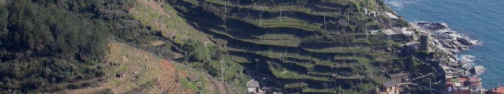
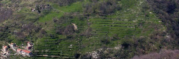
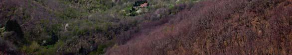
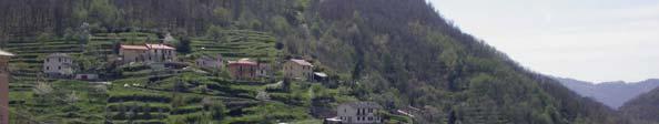
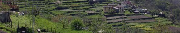
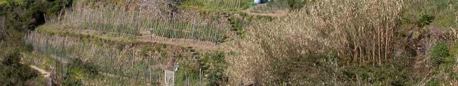
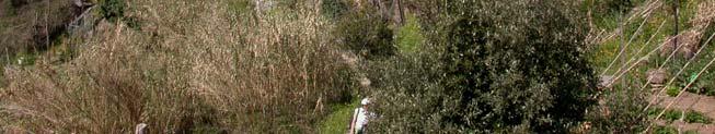
3 Along the past centuries man has induced deep changes in the landscape of wide areas with the aim to obtain terrain suitable to farming. This modification has been done varying the profile of the terrain to gain sub horizontal surfaces and managing the flow of the rainfall runoff. Anthropogenic modification of the slopes


4 Extension of terraced areas More than 20% of Ligurian territory


5 Man made terraces may be regarded as an ancient industrial large scale modification of the territory. In the past, in some areas, this kind of modification represented the main economical activity
 was and is famous for vineyard and lemons.")

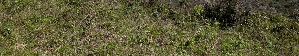
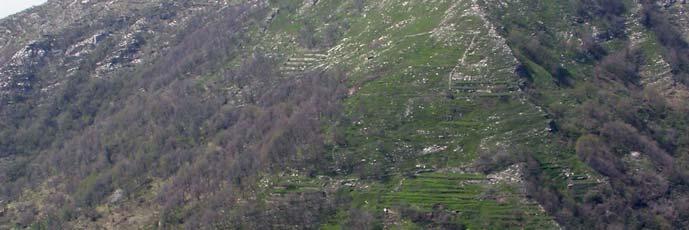
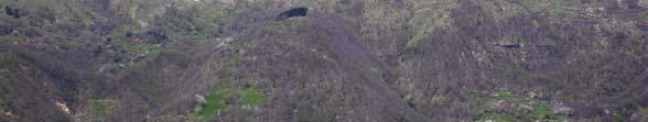
6 The Argentina valley (2) was famous for corn cultivation. The Cinque Terre area (3) was and is famous for vineyard and lemons. Other areas (1) where mainly used for less precious cultivation practices like chestnut and others. Some areas nearby the coastline where mainly used for the olive

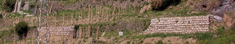
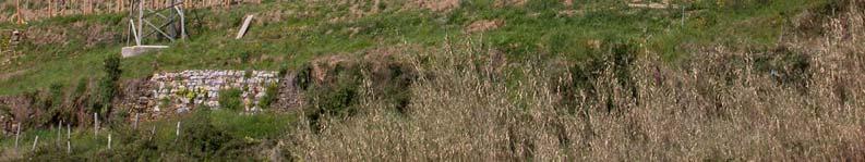
7 Various building up techniques
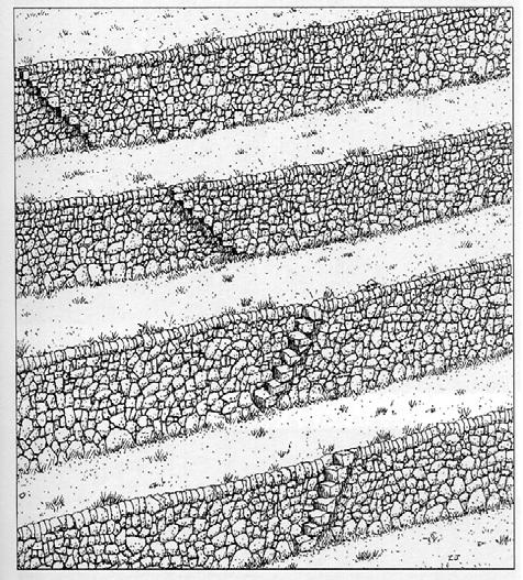
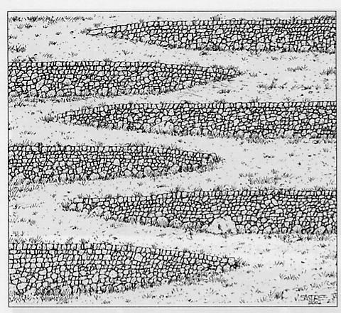
8 Terraces dispositions REGULAR AND CONTINUOUS CONCENTRIC PARALLEL DISCONTINUOS IRREGULAR

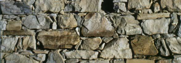
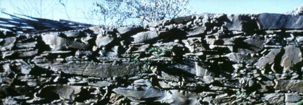
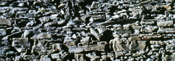
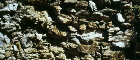
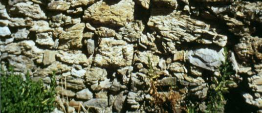
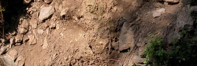
9 LITHOLOGY AND STONES DISPOSITIONS


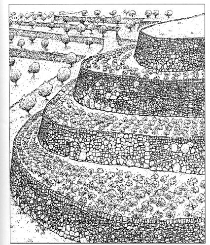
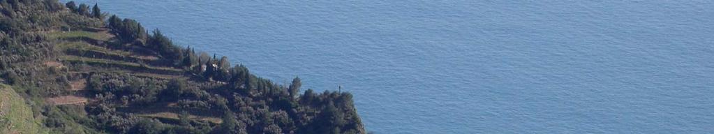
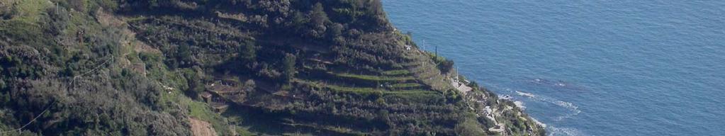
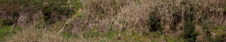
10 5 Terre, a terraced landscape


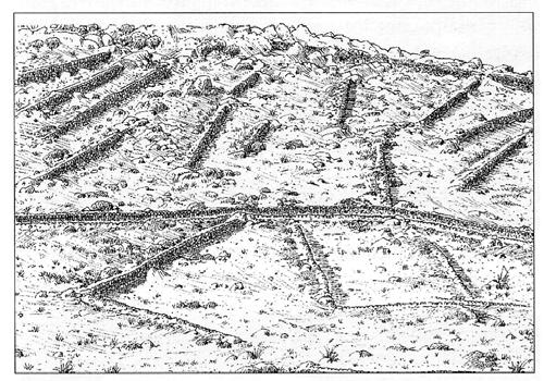
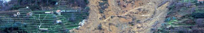
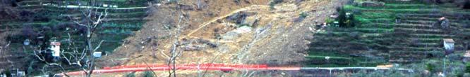
11 Terraces are spread from sea level to the main watershed
12
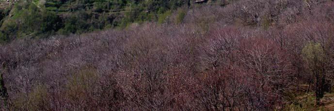
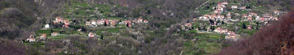
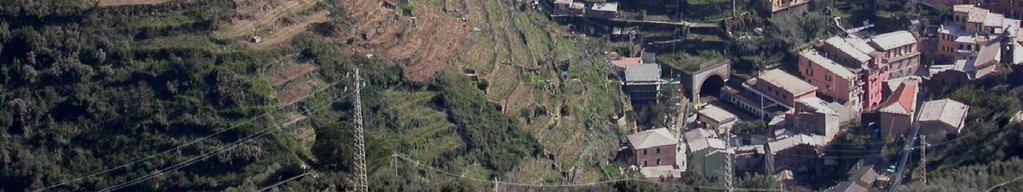
13 The hinterland of Genova: the Bisagno basin
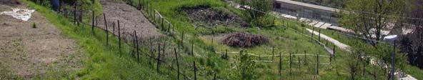
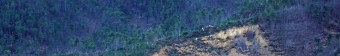
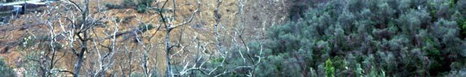
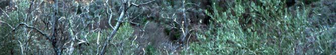
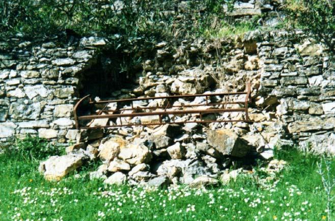
14 Actually most of those areas are in abandon causing an increase of the hazard related with the stability of the slopes because of the lack in maintaining the terraces Those areas may be regarded as agro-industrial abandoned sites, that may cause an increase of the geomorphic hazard
15 DEGRADATION OF TERRACES


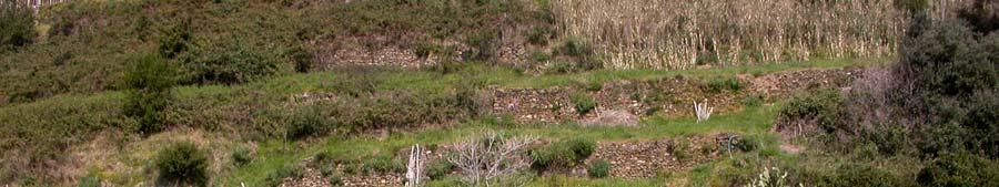
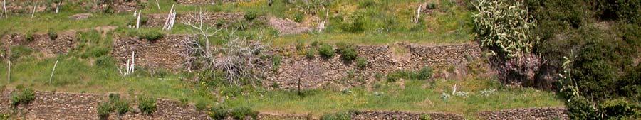
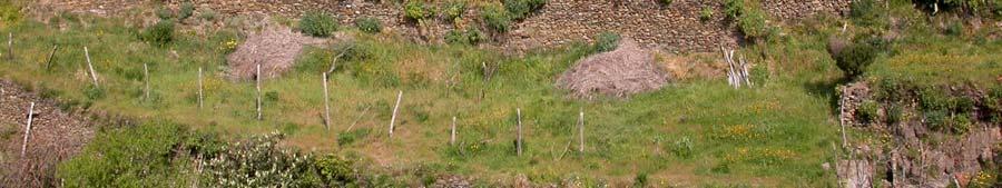
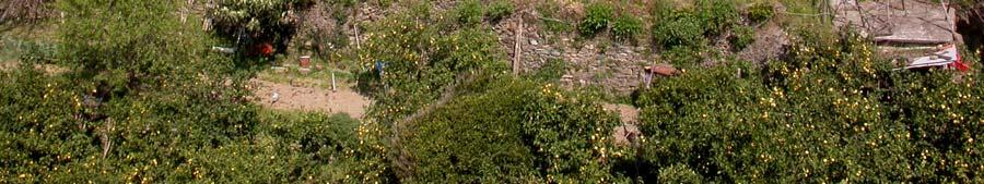
16 Managed terraces The first effects of degradation
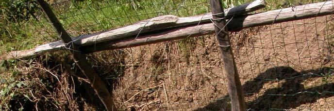
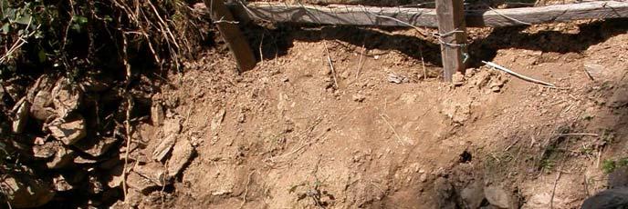
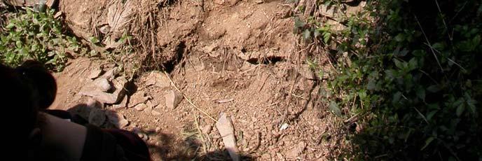

17 Degradation Wrong recovery
18 Wrong recovery The permeability of the original wall has not been conserved
19 The effect in case of severe rainfall: Landslides and heavy solid transport in the stream. The effect reach the lower part of the basin
")
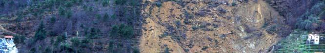
20 Ceriana (Imperia) landslides and severe flood (2000)
21 What terraces mean in term of the Geomorphic System? Man has become one of the processes aging in the geomorphic system In some situation man is one of the dominant ones. Moreover man is capable of deep changes acting in short period The effect is of putting the system out of equilibrium
22 Abandon of the hinterland Increase of the urbanisation Erosion Raise in fluvial solid transport Widespread slope instability Reduction of permeability Increase of rainfall-runoff Increase of stream transport Reduction of catchment s travel time INCREASE OF GEOMORPHIC HAZARD

23 Making terraces along large portion of the territory has induced a new equilibrium in the morphogenetic system active in the area UNTIL THE PRESIDIUM OF TERRACES Once man has abandoned terraces the morphogenetic system got out of equilibrium
24 Suddenly all the sediments being stopped for many years along the slopes became available to erosion Nowadays: the morphogenetic system is tending to a new equilibrium The effects: landslides and increase of the solid transport in streams and rivers Consequences: The coastal zone management must take into account even the management of the hinterland. We need an integrated and multidisciplinary approach to the problem.
25 Today the focal point to reduce conflicts, to get a better landscape and territory management and to reduce one of the most important factor of the hydrological hazard is To include terraces in the risk assessment procedures and strategies.
26 The Interreg III ALPTER project Loss of productive land, increase of natural hazard, loss of biodiversity and disappearance of a rich cultural heritage are all consequences of the decay of terraced structures. The project is working in areas spread all over the alpine region, to collect data, develop specific technologies and realize examples of productive recovery. The final aim is to promote large scale transformation. At the same time, a network will be build, to put in contact the different subjects involved in this topic, to permit exchange of information and cooperation

27
28 Terraces census Aerial photography, cartography, survey GIS analysis, monitoring and modeling: Decrease of damages by floods along the coast Natural processes Hazard analysis (DEM, morphometry of the surface, floods, landslides ) Hazard maps Infrastructures, towns Vulnerability assessment Risk maps Risk analysis
29 The first step: census of terraces (condition, use, type of vegetation ) Field survey Census Aerial photography and cartographic analysis Definition of the real extension
30 The second step: modelling the hazard One of the contribution to the project that the Laboratory of Applied Geomorphology is going to develop together with the Regione Liguria Spatial and Landscape Planning Department is a model to quickly and precisely monitor and survey the terraced territory with the aim of GIS technologies and to predict the geomorphic hazard in a large and complex area.


31 Integration of surveyed data and morphometry data Dynamic model of geomorphic hazard The model will allow to individuate the areas where the recovery is indispensable

32 Gerardo Brancucci, Guido Paliaga Laboratory of Applied Geomorphology, POLIS Dep.t Faculty of Architecture, University of Genova Stradone S. Agostino, Genova Tel.: Fax: Thank you!
The Hazard Assessment in a Terraced Landscape: Preliminary Result of the Liguria (Italy) Case Study in the Interreg III Alpter Project
 Case Study in the Interreg III Alpter Project") Proceedings Geohazards Engineering Conferences International Year 26 The Hazard Assessment in a Terraced Landscape: Preliminary Result of the Liguria (Italy) Case Study in the Interreg III Alpter Project
Proceedings Geohazards Engineering Conferences International Year 26 The Hazard Assessment in a Terraced Landscape: Preliminary Result of the Liguria (Italy) Case Study in the Interreg III Alpter Project
4.17 Spain. Catalonia
 4.17 Spain Catalonia In Spain, inundation studies are the responsibility of the respective Hydrographic Confederations of each river basin (River Basin Authorities). The actual status of inundation studies
APPROACH TO THE SPANISH WATER ORGANISATION IMPROVING FLOOD HAZARD MAPPING, LAWS AND AUTHORITIES COORDINATION
 "Workshop On Land Use Planning And Water Management, With Focus On Flood Risk Management Oslo, Norway. Wednesday 31 January and Thursday 1 February 2007 APPROACH TO THE SPANISH WATER ORGANISATION IMPROVING
GEOMORPHOLOGY APPROACH IN LANDSLIDE VULNERABILITY, TANJUNG PALAS TENGAH, EAST KALIMANTAN, INDONESIA
 GEOMORPHOLOGY APPROACH IN LANDSLIDE VULNERABILITY, TANJUNG PALAS TENGAH, EAST KALIMANTAN, INDONESIA *Twin H. W. Kristyanto Geology Study Program, FMIPA UI, Universitas Indonesia *Author for Correspondence:
Debris flow: categories, characteristics, hazard assessment, mitigation measures. Hariklia D. SKILODIMOU, George D. BATHRELLOS
 Debris flow: categories, characteristics, hazard assessment, mitigation measures Hariklia D. SKILODIMOU, George D. BATHRELLOS Natural hazards: physical phenomena, active in geological time capable of producing
International Conference Analysis and Management of Changing Risks for Natural Hazards November 2014 l Padua, Italy
 Abstract code: AP5 Mapping direct and indirect fluvial hazard in the Middle Calore River valley (southern Italy) P. Magliulo 1, A. Valente 1 1 Dipartimento di Scienze e Tecnologie, Università degli Studi
Eagle Creek Post Fire Erosion Hazard Analysis Using the WEPP Model. John Rogers & Lauren McKinney
 Eagle Creek Post Fire Erosion Hazard Analysis Using the WEPP Model John Rogers & Lauren McKinney Columbia River Gorge at Risk: Using LiDAR and GIS-based predictive modeling for regional-scale erosion susceptibility
Semester: Two. Study Hours: 28 contact/80 independent BSU Credits: 10 ECTS: 5
 BATH SPA UNIVERSITY Erasmus, exchange & study abroad module catalogue Geography: semester 2 Modules at Bath Spa University are usually worth either 10, 20 or 40 credits. If you are using the European Credit
Geography Class XI Fundamentals of Physical Geography Section A Total Periods : 140 Total Marks : 70. Periods Topic Subject Matter Geographical Skills
 Geography Class XI Fundamentals of Physical Geography Section A Total Periods : 140 Total Marks : 70 Sr. No. 01 Periods Topic Subject Matter Geographical Skills Nature and Scope Definition, nature, i)
Need of Proper Development in Hilly Urban Areas to Avoid
 Need of Proper Development in Hilly Urban Areas to Avoid Landslide Hazard Dr. Arvind Phukan, P.E. Cosultant/Former Professor of Civil Engineering University of Alaska, Anchorage, USA RI District Governor
River Response. Sediment Water Wood. Confinement. Bank material. Channel morphology. Valley slope. Riparian vegetation.
 River Response River Response Sediment Water Wood Confinement Valley slope Channel morphology Bank material Flow obstructions Riparian vegetation climate catchment vegetation hydrological regime channel
Gully erosion and associated risks in the Tutova basin Moldavian Plateau
 Landform Analysis, Vol. 17: 193 197 (2011) Gully erosion and associated risks in the Tutova basin Moldavian Plateau University Alexandru Ioan Cuza of Iasi, Department of Geography, Romania, e-mail: catiul@yahoo.com
Fluvial Processes In Dryland Rivers
 WILLIAM L. GRAF Fluvial Processes In Dryland Rivers Reprint of First Edition, Copyright 1988 Copyright 2002 by William L. Graf All rights reserved. No part of this book may be reproduced, stored in a retrieval
Physical landscapes River landscapes in the UK
 Physical landscapes River landscapes in the UK The shape of river valleys change s as rivers flow downstream - PROCESSES Erosion Abrasion or corrasion Attrition Hydraulic Action Solution or corrosion Deposition
Vulnerability assessment of Sta.Rosa-Silang subwatershed using SWAT
 Vulnerability assessment of Sta.Rosa-Silang subwatershed using SWAT Damasa B. Magcale-Macandog, Charles Gunay and Milben A. Bragais Institute of Biological Sciences, University of the Philippines Los Baños,
NATURE OF RIVERS B-1. Channel Function... ALLUVIAL FEATURES. ... to successfully carry sediment and water from the watershed. ...dissipate energy.
 1 2 Function... Sevier River... to successfully carry sediment and water from the watershed....dissipate energy. 3 ALLUVIAL FEATURES 4 CHANNEL DIMENSION The purpose of a stream is to carry water and sediment
AASHTO Extreme Weather Events Symposium Vermont s Road and Rivers - Managing for the Future
 AASHTO Extreme Weather Events Symposium Vermont s Road and Rivers - Managing for the Future May 22, 2013 PLANET EARTH 2 2 MANY MANYYEARS AGO 23,000 years ago there was more than 8,000 feet of glacier over
Cycles, Systems and Changing Places 5 days
 AS Level Geography AQA Cycles, Systems and Changing Places 5 days Complete the fieldwork requirements for AS level students within physical and human environments. Fieldwork in these locations provides
Candidate Name Centre Number Candidate Number CHANGING PHYSICAL AND HUMAN LANDSCAPES SAMPLE ASSESSMENT MATERIALS
 GCSE GEOGRAPHY Sample Assessment Materials 5 Candidate Name Centre Number Candidate Number 0 GCSE GEOGRAPHY UNIT 1 CHANGING PHYSICAL AND HUMAN LANDSCAPES SAMPLE ASSESSMENT MATERIALS 1 hour 30 minutes Section
Using Weather and Climate Information for Landslide Prevention and Mitigation
 Using Weather and Climate Information for Landslide Prevention and Mitigation Professor Roy C. Sidle Disaster Prevention Research Institute Kyoto University, Japan International Workshop on Climate and
SPATIAL MODELS FOR THE DEFINITION OF LANDSLIDE SUSCEPTIBILITY AND LANDSLIDE HAZARD. J.L. Zêzere Centre of Geographical Studies University of Lisbon
 SPATIAL MODELS FOR THE DEFINITION OF LANDSLIDE SUSCEPTIBILITY AND LANDSLIDE HAZARD J.L. Zêzere Centre of Geographical Studies University of Lisbon CONCEPTUAL MODEL OF LANDSLIDE RISK Dangerous Phenomena
Modeling Post-Development Runoff and Channel Impacts from Hydromodification: Practical Tools for Hydromodification Assessment
 Modeling Post-Development Runoff and Channel Impacts from Hydromodification: Practical Tools for Hydromodification Assessment Chris Bowles, Ph.D. Andy Collison, Ph.D. Matt Wickland, M.S. c.bowles@pwa-ltd.com
Geog Lecture 19
 Geog 1000 - Lecture 19 Fluvial Geomorphology and River Systems http://scholar.ulethbridge.ca/chasmer/classes/ Today s Lecture (Pgs 346 355) 1. What is Fluvial Geomorphology? 2. Hydrology and the Water
Historical channel change on the Upper Gila River, Arizona and New Mexico in response to anthropogenic modifications and extreme floods
 Historical channel change on the Upper Gila River, Arizona and New Mexico in response to anthropogenic modifications and extreme floods www.archives.gov www.paztcn.wr.usgs.gov wrh.noaa.gov Upper Gila River
USING 3D GIS TO ASSESS ENVIRONMENTAL FLOOD HAZARDS IN MINA
 King Fahd University of Petroleum & Minerals College of Environmental Design Geographical Information system USING 3D GIS TO ASSESS ENVIRONMENTAL FLOOD HAZARDS IN MINA Prepared by : Ali AL-Zahrani OUTLINE
Margarita Stancheva Hristo Stanchev & Robert Young 2. MEDCOAST JUBILEE WORKSHOP May 2015, Iberotel Sarigerme Park, Dalaman, Turkey
 Margarita Stancheva Hristo Stanchev & Robert Young 2 INTRODUCTION: Bulgarian Black Sea coast INTRODUCTION: Increasing pressure on Bulgarian coastal zone In 2011, of the 7 364 570 people that lived in Bulgaria,
Landslide Susceptibility, Hazard, and Risk Assessment. Twin Hosea W. K. Advisor: Prof. C.T. Lee
 Landslide Susceptibility, Hazard, and Risk Assessment Twin Hosea W. K. Advisor: Prof. C.T. Lee Date: 2018/05/24 1 OUTLINE INTRODUCTION LANDSLIDE HAZARD ASSESSTMENT LOGISTIC REGRESSION IN LSA STUDY CASE
Chapter 1 Quantitative Analysis of Geomorphometric Parameters of Wadi Kerak, Jordan, Using Remote Sensing and GIS
 Chapter 1 Quantitative Analysis of Geomorphometric Parameters of Wadi Kerak, Jordan, Using Remote Sensing and GIS Yahya Farhan, Ali Anbar, Omar Enaba, Nisrin Al-Shaikh Geomorphometric analysis was carried
Landscape evolution. An Anthropic landscape is the landscape modified by humans for their activities and life
 Landforms Landscape evolution A Natural landscape is the original landscape that exists before it is acted upon by human culture. An Anthropic landscape is the landscape modified by humans for their activities
mountain rivers fixed channel boundaries (bedrock banks and bed) high transport capacity low storage input output
 high transport capacity low storage input output") mountain rivers fixed channel boundaries (bedrock banks and bed) high transport capacity low storage input output strong interaction between streams & hillslopes Sediment Budgets for Mountain Rivers Little
mountain rivers fixed channel boundaries (bedrock banks and bed) high transport capacity low storage input output strong interaction between streams & hillslopes Sediment Budgets for Mountain Rivers Little
Landscape Development
 Landscape Development Slopes Dominate Natural Landscapes Created by the interplay of tectonic and igneous activity and gradation Deformation and uplift Volcanic activity Agents of gradation Mass wasting
Graduate Courses Meteorology / Atmospheric Science UNC Charlotte
 Graduate Courses Meteorology / Atmospheric Science UNC Charlotte In order to inform prospective M.S. Earth Science students as to what graduate-level courses are offered across the broad disciplines of
This table connects the content provided by Education Perfect to the NSW Syllabus.
 Education Perfect Geography provides teachers with a wide range of quality, engaging and innovative content to drive positive student learning outcomes. Designed by teachers and written by our in-house
Modeling Great Britain s Flood Defenses. Flood Defense in Great Britain. By Dr. Yizhong Qu
 Modeling Great Britain s Flood Defenses AIRCurrents Editor s note: AIR launched its Inland Flood Model for Great Britain in December 2008. The hazard module captures the physical processes of rainfall-runoff
Step 5: Channel Bed and Planform Changes
 Step 5: Channel Bed and Planform Changes When disturbed, streams go through a series of adjustments to regain equilibrium with the flow and sediment supply of their watersheds. These adjustments often
Regaining sediments: the Orba River lower reach bank erosions (NW Italy)
") Regaining sediments: the Orba River lower reach bank erosions (NW Italy) Mandarino A. (1)*, Maerker M. (2), Zucca F. (2), Firpo M. (1) (1) Department of Earth, Environment and Life Sciences (DISTAV), University
Regaining sediments: the Orba River lower reach bank erosions (NW Italy) Mandarino A. (1)*, Maerker M. (2), Zucca F. (2), Firpo M. (1) (1) Department of Earth, Environment and Life Sciences (DISTAV), University
What hit us Notes on the Physical Geography of Hurricanes Irma and Maria
 What hit us Notes on the Physical Geography of Hurricanes Irma and Maria Carlos E Ramos-Scharron Department of Geography & the Environment and LLILAS UT-Austin Objectives Central theme is MAGNITUDE How
Dr. S.SURIYA. Assistant professor. Department of Civil Engineering. B. S. Abdur Rahman University. Chennai
 Hydrograph simulation for a rural watershed using SCS curve number and Geographic Information System Dr. S.SURIYA Assistant professor Department of Civil Engineering B. S. Abdur Rahman University Chennai
Assessment of solid load and siltation potential of dams reservoirs in the High Atlas of Marrakech (Moorcco) using SWAT Model
 using SWAT Model") Assessment of solid load and siltation potential of dams reservoirs in the High Atlas of Marrakech (Moorcco) using SWAT Model Amal Markhi: Phd Student Supervisor: Pr :N.Laftrouhi Contextualization Facing
Assessment of solid load and siltation potential of dams reservoirs in the High Atlas of Marrakech (Moorcco) using SWAT Model Amal Markhi: Phd Student Supervisor: Pr :N.Laftrouhi Contextualization Facing
Department of Geography: Vivekananda College for Women. Barisha, Kolkata-8. Syllabus of Post graduate Course in Geography
 India: Regional Problems and Resource management Module 11 (Full Marks 50) Unit I: Region and Regionalisation 1.1 Various bases of regionalisation of India; problems of identification and delineation.
Interregional Cooperation in the Apennines
 INTERNATIONAL WORKSHOP THE ALPS AND THE ARDENNES: SHARING EXPERIENCES AMONG TRANSBOUNDARY MOUNTAIN AREAS Interregional Cooperation in the Apennines Massimo Sargolini, professor at the University of Camerino,
Natural hazards in Glenorchy Summary Report May 2010
 Natural hazards in Glenorchy Summary Report May 2010 Contents Glenorchy s hazardscape Environment setting Flood hazard Earthquakes and seismic hazards Hazards Mass movement Summary Glossary Introduction
CAPE Unit 1 Module 2 & 3. Topic Specific Objectives Content Explain the main concepts, flows and processes associated with coastal environments
 # Week(s) Wks 1-3 CAPE Unit 1 Module 2 & 3 Topic Specific Objectives Content Explain the main concepts, flows and processes associated with coastal environments Wave formation, structure, types Textbook
Coastal Viewer Mapping Application:
 Coastal Viewer Mapping Application: MAPPING OF COASTAL PUBLIC PROPERTY, THE COASTAL PROTECTION ZONE BOUNDARIES AND AUDITING OF STRUCTURES ON THE COASTAL PUBLIC PROPERTY 15 May 2014 INTEGRATED COASTAL MANAGEMENT
Methodological cues for the analysis of the terraced slope in the pilot area Pianazzola-Bregaglia Data Sheet Analysis 1:5000
 Project Alpter Methodological cues for the analysis of the terraced slope in the pilot area Pianazzola-Bregaglia Data Sheet Analysis 1:5 Alice G. Dal Borgo - Human Geography Institute, State University
Nguyen Ngoc Thach 1, *, Pham Xuan Canh 2 VNU University of Science, 334 Nguyen Trai, Hanoi, Vietnam
 VNU Journal of Science, Earth Sciences 8 (01) 44-6 Risk assessment of flash muddy flood and inundation of western Tam Dao mountainous region, Vinh Phuc province, Vietnam by using intergrated concept of
CAUSES FOR CHANGE IN STREAM-CHANNEL MORPHOLOGY
 CAUSES FOR CHANGE IN STREAM-CHANNEL MORPHOLOGY Chad A. Whaley, Department of Earth Sciences, University of South Alabama, MobileAL, 36688. E-MAIL: caw408@jaguar1.usouthal.edu The ultimate goal of this
THE UNIVERSITY of TORONTO at SCARBOROUGH January, 2010 Department of Physical & Environmental Sciences
 THE UNIVERSITY of TORONTO at SCARBOROUGH January, 2010 Department of Physical & Environmental Sciences Environmental Science EES B02H3 PRINCIPLES OF GEOMORPHOLOGY The earth s surface form and its dynamic
Wetland & Floodplain Functional Assessments and Mapping To Protect and Restore Riverine Systems in Vermont. Mike Kline and Laura Lapierre Vermont DEC
 Wetland & Floodplain Functional Assessments and Mapping To Protect and Restore Riverine Systems in Vermont Mike Kline and Laura Lapierre Vermont DEC NWI+ Hydro-Geomorphic Characterization of Wetlands and
GENERAL. CHAPTER 1 BACKGROUND AND PURPOSE OF THE GUIDELINES Background of the Guidelines Purpose of the Guidelines...
 GENERAL CHAPTER 1 BACKGROUND AND PURPOSE OF THE GUIDELINES... 1 1.1 Background of the Guidelines... 1 1.2 Purpose of the Guidelines... 3 CHAPTER 2 APPLICATION OF THE GUIDELINES... 3 2.1 Potential Users
Remote Sensing and GIS Contribution to. Tsunami Risk Sites Detection. of Coastal Areas in the Mediterranean
 The Third International Conference on Early Warning (EWC III), 26.-29.March 2006 in Bonn Remote Sensing and GIS Contribution to Tsunami Risk Sites Detection of Coastal Areas in the Mediterranean BARBARA
Science EOG Review: Landforms
 Mathematician Science EOG Review: Landforms Vocabulary Definition Term canyon deep, large, V- shaped valley formed by a river over millions of years of erosion; sometimes called gorges (example: Linville
3l NATURAL HAZARDS AND UNSTABLE GROUND
 Page 1 of Section 3l 3l NATURAL HAZARDS AND UNSTABLE GROUND 3l.1 Introduction A natural hazard is the result of natural processes that form, shape and change the environment and interact or potentially
Spatial Disaggregation of Land Cover and Cropping Information: Current Results and Further steps
 CAPRI CAPRI Spatial Disaggregation of Land Cover and Cropping Information: Current Results and Further steps Renate Koeble, Adrian Leip (Joint Research Centre) Markus Kempen (Universitaet Bonn) JRC-AL
SESSION 6: FLUVIAL LANDFORMS
 SESSION 6: FLUVIAL LANDFORMS KEY CONCEPTS: Fluvial Landforms Management of River Catchment Areas Slope Elements X-PLANATION: FLUVIAL LANDFORMS Rivers form landforms as they erode the landscape. These landforms
Fluvial Systems Lab Environmental Geology Lab Dr. Johnson
 Fluvial Systems Lab Environmental Geology Lab Dr. Johnson *Introductory sections of this lab were adapted from Pidwirny, M. (2006). "Streamflow and Fluvial Processes". Fundamentals of Physical Geography,
International Symposium on Natural Disaster Mitigation. Local vulnerability assessment of landslides and debris flows
 International Symposium on Natural Disaster Mitigation of landslides and debris flows Lessons learnt from Cam Pha town and Van Don district, Quang Ninh province, Vietnam Nguyen Quoc Phi Faculty of Environment
Minimizing Flood Risks and Habitat Impacts Due to Post-Flood Recovery Efforts
 Minimizing Flood Risks and Habitat Impacts Due to Post-Flood Recovery Efforts Roy Schiff, Milone & MacBroom, Inc. Mike Kline, Vermont Agency of Natural Resources Shayne Jaquith, Vermont Agency of Natural
Holocene evolution of Dahab coastline Gulf of Aqaba, Sinai Peninsula, Egypt 1
 Holocene evolution of Dahab coastline Gulf of Aqaba, Sinai Peninsula, Egypt 1 Magdy Torab* 2 * Prof. of Geomorphology, Department of Geography, Damanhour University, Egypt 3 E-mail: magdytorab@hotmail.com.
The Effects of Hydraulic Structures on Streams Prone to Bank Erosion in an Intense Flood Event: A Case Study from Eastern Hokkaido
 Symposium Proceedings of the INTERPRAENENT 2018 in the Pacific Rim The Effects of Hydraulic Structures on Streams Prone to Bank Erosion in an Intense Flood Event: A Case Study from Eastern Hokkaido Daisuke
Fluvial Geomorphic Guidelines
 Fluvial Geomorphic Guidelines FACT SHEET I: GEOMORPHOLOGICAL HAZARDS CONFINED AND UNCONFINED WATERCOURSES Channel migration and erosion can create substantial risk to inappropriately located infrastructure
Integrated and Multi-Hazard Disaster Management
 GeoSmart Asia 2016: GI for Disaster Preparedness and Risk Reduction Bandung, Indonesia 12 October 2016 Integrated and Multi-Hazard Disaster Management Lim Choun Sian & Nurfashareena Muhamad Centre for
8 Current Issues and Research on Sediment Movement in the River Catchments of Japan
 8 Current Issues and Research on Sediment Movement in the River Catchments of Japan YUTAKA ICHIKAWA INTRODUCTION Prediction of sediment movement is one of the challenging tasks in water-related research.
Considerations on debris-flow hazard analysis, risk assessment and management.
 European Geosciences Union General Assembly 2008, 14-18 April, Vienna Considerations on debris-flow hazard analysis, risk assessment and management. A. Remaître 1, J.-P. Malet 1, O. Maquaire 2 1. CNRS
For the multiple-choice questions, completely fill in the circle alongside the appropriate answer.
 DRAFT SPECIMEN MATERIAL A-level GEOGRAPHY Paper 1 Physical geography Specimen Question Paper Time allowed: 2 hours 30 minutes Materials For this paper you must have: a pencil a rubber a ruler. You may
ENVIRONMENTAL GEOSCIENCE UNIFORM SYLLABUS
 ENVIRONMENTAL GEOSCIENCE UNIFORM SYLLABUS The Association of Professional Engineers and Geoscientists of the Province of British Columbia Note: 1. This Syllabus May Be Subject To Change 2. These Courses
APPLICATION TO PAST DISASTERS OF A METHOD OF SETTING THE RANGE OF DEBRIS FLOW DAMAGE TO HOUSES
 APPLICATION TO PAST DISASTERS OF A METHOD OF SETTING THE RANGE OF DEBRIS FLOW DAMAGE TO HOUSES Hideaki MIZUNO Senior Researcher Erosion and Sediment Control National Institute for Land and Infrastructure
WATERCOURSE HARNESSING BANK EROSION AND CONSOLIDATION
 GUVERNUL MINISTERUL POSDRU MUNCII, FAMILIEI ŞI WATERCOURSE HARNESSING BANK EROSION AND CONSOLIDATION PhD. student: ALUPOAE Daniel Gheorghe Asachi Technical University of Iasi, Faculty of Civil Engineering
Review Using the Geographical Information System and Remote Sensing Techniques for Soil Erosion Assessment
 Polish J. of Environ. Stud. Vol. 19, No. 5 (2010), 881-886 Review Using the Geographical Information System and Remote Sensing Techniques for Soil Erosion Assessment Nuket Benzer* Landscape Architecture
Title: Concepts of Flood Risk
 Title: Concepts of Flood Risk Title Prepared by: Dr. Mohammed Abdulkadir and Dr. Micha Werner Outline of presentation Hazards Flood Event Flood losses Classification of floods Flood management Concepts
GLY Coastal Geomorphology Notes
 GLY 4734 - Coastal Geomorphology Notes Dr. Peter N. Adams Spring 2011 2 Coastal Classification In this lecture, we discuss some successful classification schemes of the coastal landscape, and pay particular
3.3 CLIMATE, GEOLOGY, TOPOGRAPHY, AND SOILS CLIMATE GEOLOGY TOPOGRAPHY
 3.3 CLIMATE, GEOLOGY, TOPOGRAPHY, AND SOILS This section describes the climate, geology, topography, and soil resource characteristics of the Yolo Bypass Wildlife Area (Wildlife Area). Agricultural soil
Disaster Risk Assessment: Opportunities for GIS and data management with Open DRI
 Disaster Risk Assessment: Opportunities for GIS and data management with Open DRI Jacob Opadeyi Department of Geomatics Engineering and Land Management, The University of the West Indies, St. Augustine,
Which map shows the stream drainage pattern that most likely formed on the surface of this volcano? A) B)
 B)") 1. When snow cover on the land melts, the water will most likely become surface runoff if the land surface is A) frozen B) porous C) grass covered D) unconsolidated gravel Base your answers to questions
1. When snow cover on the land melts, the water will most likely become surface runoff if the land surface is A) frozen B) porous C) grass covered D) unconsolidated gravel Base your answers to questions
Monitoring Headwater Streams for Landscape Response to
 Monitoring Headwater Streams for Landscape Response to Climate Change Matthew Connor, PhD Connor nvironmental, nc. www.oe-i.com icom Healdsburg, California verview Headwater stream geomorphology Response
Environmental accounting of hillslope processes in central Tuscany (Italy)
") Environmental accounting of hillslope processes in central Tuscany (Italy) Francesca Bianchi, Filippo Catani & Sandro Moretti Earth Sciences Department, University of Firenze, Italy. Abstract Many recent
Environmental accounting of hillslope processes in central Tuscany (Italy) Francesca Bianchi, Filippo Catani & Sandro Moretti Earth Sciences Department, University of Firenze, Italy. Abstract Many recent
Luca Guerrieri Valerio Comerci Eutizio Vittori
 Earthquake Environmental Effects induced by the 1908 December 28 th Messina earthquake: an in-situ contribute to the Messina supersite (GEO Task DI-09-01a Vulnerability Mapping and Risk Assessment Luca
Controlling Processes That Change Land
 1 Name Date Controlling Processes That Change Land People try to control some of the processes that change land. To do this, people apply technology- the use of science to solve problems in everyday life.
Fresh Water: Streams, Lakes Groundwater & Wetlands
 Fresh Water:, Lakes Groundwater & Wetlands Oct 27 Glaciers and Ice Ages Chp 13 Nov 3 Deserts and Wind and EXAM #3 Slope hydrologic cycle P = precip I = precip intercepted by veg ET = evapotranspiration
AS & A2 Geography for OCR. Tailored Courses. Slapton Ley
 AS & A2 Geography for OCR Tailored Courses Slapton Ley Please visit http://www.field-studies-council.org/outdoorclassroom/geography/aqa/ for alternative A-level AQA programmes OVERVIEW Since the assessment
GEOL 1121 Earth Processes and Environments
 GEOL 1121 Earth Processes and Environments Wondwosen Seyoum Department of Geology University of Georgia e-mail: seyoum@uga.edu G/G Bldg., Rm. No. 122 Seyoum, 2015 Chapter 6 Streams and Flooding Seyoum,
SECTION II Hydrological risk
 Chapter 3 Understanding disaster risk: hazard related risk issues SECTION II Hydrological risk Peter Salamon Coordinating lead author Hannah Cloke Lead author 3.4 Giuliano di Baldassarre Owen Landeg Florian
Why Geomorphology for Fish Passage
 Channel Morphology - Stream Crossing Interactions An Overview Michael Love Michael Love & Associates mlove@h2odesigns.com (707) 476-8938 Why Geomorphology for Fish Passage 1. Understand the Scale of the
Stream Geomorphology. Leslie A. Morrissey UVM July 25, 2012
 Stream Geomorphology Leslie A. Morrissey UVM July 25, 2012 What Functions do Healthy Streams Provide? Flood mitigation Water supply Water quality Sediment storage and transport Habitat Recreation Transportation
CLIMATE RESILIENT ALTITUDINAL GRADIENTS (CRAGs)
") CLIMATE RESILIENT ALTITUDINAL GRADIENTS (CRAGs) BUILDING CLIMATE CHANGE RESILIENCE IN THE KIVU- RUSIZI WATERSHEDS Great Lake Conference Entebbe 2017 Chris Magero WHAT ARE CRAGs? Climate-Resilient Altitudinal
CLIMATE RESILIENT ALTITUDINAL GRADIENTS (CRAGs) BUILDING CLIMATE CHANGE RESILIENCE IN THE KIVU- RUSIZI WATERSHEDS Great Lake Conference Entebbe 2017 Chris Magero WHAT ARE CRAGs? Climate-Resilient Altitudinal
M.A. / M.Sc. Course in Geography
 SYLLABUS for the M.A. / M.Sc. Course in Geography Two Year Post Graduate Course with Choice Based Credit System Semester-I Session: 2018-2020 Directorate of Open and Distance Learning (DODL) University
Impacts of Climate Change and Water-Related Disaster Reduction Management in the Asia-Pacific Region
 Impacts of Climate Change and Water-Related Disaster Reduction Management in the Asia-Pacific Region Katumi MUSIAKE Professor, Fukushima University Secretary General, Asia Pacific Association of Hydrology
2013 Esri Europe, Middle East and Africa User Conference October 23-25, 2013 Munich, Germany
 2013 Esri Europe, Middle East and Africa User Conference October 23-25, 2013 Munich, Germany Environmental and Disaster Management System in the Valles Altos Region in Carabobo / NW-Venezuela Prof.Dr.habil.Barbara
USGS Hydrography Overview. May 9, 2018
 + 1 USGS Hydrography Overview May 9, 2018 + 2 The National Geospatial Program Provides the geospatial baseline of the Nation s topography, natural landscape and built environment through The National Map,
EFFECTS OF DEBRIS-FLOW CONTROL WORKS ON ENVIRONMENT AND CONSEQUENCES FOR LAND-USE PLANNING CASE STUDY MURBACH, TYROL, AUSTRIA
 EFFECTS OF DEBRIS-FLOW CONTROL WORKS ON ENVIRONMENT AND CONSEQUENCES FOR LAND-USE PLANNING CASE STUDY MURBACH, TYROL, AUSTRIA Joerg Heumader 1* ABSTRACT The torrent Murbach is one of the most dangerous
Climate, Hazards and Distinctive Landscapes 3 days
 GCSE Geography OCR B Climate, Hazards and Distinctive Landscapes 3 days Covers all fieldwork requirements within Our Natural World, enabling students to get the grades they want within Section B of the
OCR 2008 AS and A level Geography Specification Mapping Guide
 OCR 2008 AS and A level Geography Specification Mapping Guide Contents Introduction Error! Bookmark not defined. Specification map: 2008 OCR AS and A level Geography 3 What's new? 10 Introduction This
Michael Barton School of Human Evolution & Social Change Center for Social Dynamics & Complexity
 Michael Barton School of Human Evolution & Social Change Center for Social Dynamics & Complexity Social Systems are Complex Even simple social systems are complex Complexity has grown at increasing rate
UGRC 144 Science and Technology in Our Lives/Geohazards
 UGRC 144 Science and Technology in Our Lives/Geohazards Flood and Flood Hazards Dr. Patrick Asamoah Sakyi Department of Earth Science, UG, Legon College of Education School of Continuing and Distance Education
The mega-drivers of global change
 Impact of Global change on Landslide hazard and Risk: with reference to New Zealand. Elements at risk Vulnerability Exposure to Hazard III Convegno Nazionale AIGeo In Honour of Mario PANIZZA Modena and
12/05/2016. The First step in Adaptation to future climate change Reduce Vulnerability and Exposure to present Climate Variability (IPCC 2014)
") Integrating CCA, DRR and L+D to Address Emerging Challenges due to Slow Onset Processes Joy Jacqueline Pereira (Project Leader), SEADPRI-Universiti Kebangsaan Malaysia, Nguyen Van Thang (Collaborator),
Integrating CCA, DRR and L+D to Address Emerging Challenges due to Slow Onset Processes Joy Jacqueline Pereira (Project Leader), SEADPRI-Universiti Kebangsaan Malaysia, Nguyen Van Thang (Collaborator),
GIS Application in Landslide Hazard Analysis An Example from the Shihmen Reservoir Catchment Area in Northern Taiwan
 GIS Application in Landslide Hazard Analysis An Example from the Shihmen Reservoir Catchment Area in Northern Taiwan Chyi-Tyi Lee Institute of Applied Geology, National Central University, No.300, Jungda
Landslide Hazard Assessment Methodologies in Romania
 A Scientific Network for Earthquake, Landslide and Flood Hazard Prevention SciNet NatHazPrev Landslide Hazard Assessment Methodologies in Romania In the literature the terms of susceptibility and landslide
MULTI-HAZARD RISK ASSESSMENT AND DECISION MAKING
 MULTI-HAZARD RISK ASSESSMENT AND DECISION MAKING JULINDA KEÇI Epoka University Logo of the institution CONTENT: Introduction Multi Hazard Risks Multi-Hazard Risk Assessment Quantitative Assessment Event
e Southeast Region of the United Statesg
 e Southeast of the United Statesg - relative location: the location of a place in relation to another place (i.e. south, near, bordering, next to) - barrier islands: located off the southeast coast of