A NEW SPECIES OF BENTHIC FORAMINIFERA FROM AN INLAND BAHAMIAN CARBONATE MARSH
|
|
|
- May Warren
- 5 years ago
- Views:
Transcription
1 Journal of Foraminiferal Research, v. 46, no. 2, p , April 2016 A NEW SPECIES OF BENTHIC FORAMINIFERA FROM AN INLAND BAHAMIAN CARBONATE MARSH PETER J. VAN HENGSTUM 1,2,4 AND JOAN M. BERNHARD 3 ABSTRACT A new benthic foraminifer, Helenina davescottensis nov. sp., is described from an oligohaline carbonate marsh (palustrine environment) located in a sinkhole on Grand Bahama Island, The Bahamas. The uppermost stratigraphy in the sinkhole is characterized by up to 260 cm of peat, which is overlain by 5 10 cm of carbonate sediment that contain H. davescottensis. Ontogenetic variability is illustrated with a full sequence of individuals from two chambers (proloculus + first chamber) through eight chambers. Chamber arrangement is planispiral evolute in juveniles that have fewer than three chambers, but arrangement changes to trochospiral evolute when the fourth chamber is added. Adults rarely exceeded 6 7 chambers and were never observed with more than 8 chambers. Supplementary apertures are common and diverse, and multichambered individuals typically achieve mm in diameter. Helenina davescottensis was found co-occurring with other low-oligohaline microfossils (Jadammina macrescens, testate amoebae, charophytes, and hydrobiid gastropods), but not other common euryhaline hyaline foraminifera (e.g., H. anderseni, Ammonia tepida). Given the sinkhole stratigraphy, perhaps H. davescottensis was an early colonizer of a recently generated palustrine environment. INTRODUCTION The Bahamian archipelago is an extensive network of carbonate islands and shallow banks in the tropical North Atlantic Ocean that cover,300,000 km 2 (Carew & Mylroie, 1997). The two largest carbonate banks in the northwestern Bahamas are the Little Bahama Bank and Great Bahama Bank, which remain separated from each other by the Northwest Providence Channel. Geophysical and subsurface-drilling surveys indicate that the shallowwater carbonates primarily comprising these banks likely began forming in the late Jurassic or early Cretaceous (Meyerhoff & Hatten, 1974; Sheridan et al., 1988; Melim & Masaferro, 1997), and they are now at least 5 km thick (Mullins & Lynts, 1977). The modern surficial geology of the northern Bahamas is characterized by large eolianite ridges (Kindler & Hearty, 1997), with abundant carbonate sediment production in the adjacent shallow marine environments (Neumann & Land, 1975; Milliman et al., 1993; Maloof & Grotzinger, 2012). Extensive dissolution and modification of these antecedent carbonates over geologic time has created a mature karstified landscape in the Bahamas, which is characterized 1 Department of Marine Science, Texas A&M University at Galveston, Galveston, Texas, USA, Department of Oceanography, Texas A&M University, College Station, Texas, USA, Department of Geology and Geophysics, Woods Hole Oceanographic Institution, Woods Hole, Massachusetts, USA Correspondence author: vanhenp@tamug.edu by abundant dissolution features such as karren, epikarst, sinkholes and blueholes, caves, and coastal biokarst (Cunliffe, 1985; Harris et al., 1995; Mylroie et al., 1995b; Walker et al., 2008). Deep, steep-walled sinkholes (Mylroie et al., 1995a) receive considerable attention for their preservation of Quaternary vertebrate fossils, Lucayan remains, and terrestrial paleoclimate records (Kjellmark, 1996; Steadman et al., 2007; Slayton, 2010), and they appear conspicuously on satellite imagery in both subaerial (e.g., uN, uW) and shallowly-submerged settings (e.g., uN, uW). From a hydrogeologic perspective, deep sinkholes and blue holes can permit observation of a complete groundwater profile, so they have been traditionally targeted to study the circulation and chemistry of subterranean aquifers (Moore et al., 1992; Whitaker & Smart, 1997). Most ecosystem research in coastal karst basins (caves, sinkholes) is focused on the biology and biogeography of their endemic metazoans (Iliffe et al., 1983; Gonzalez et al., 2013; Jaume et al., 2013) and bacteria (Gonzalez et al., 2011), with considerably less attention devoted to understanding their protistan communities. However, diverse assemblages of benthic foraminifera and testate amoebae (i.e., thecamoebians) have been described in North Atlantic coastal karst basins (van Hengstum et al., 2008; 2009; van Hengstum & Scott, 2011). With the limited knowledge gained thus far from modern distributional studies, cave foraminifera and testate amoebae have been successfully used to reconstruct and evaluate groundwater circulation, salinity changes, and groundwater-level rise through the Holocene in response to sea-level and climate forcing (van Hengstum et al., 2010, 2011; van Hengstum & Scott, 2012; Collins et al., 2015). However, additional research on modern foraminiferal ecology and distributions in karst basins is needed to fully realize the potential of benthic foraminifera in this emerging capacity. In addition to deep, flooded sinkholes, there are also shallow and inconspicuous sinkholes on the Bahamian subaerial landscape (e.g., uN, uW; uN, uW; or uN, uW). Some of these sites may have formed by dissolution during the Marine Isotope Stage 5e transgression (Harris et al., 1995), but others may be deep sinkholes that have become infilled with sediment. Despite their inland position, these shallow sinkholes may contain fresh to slightly brackish marsh environments, and they can be colonized by sawgrass, Rhizophora (mangrove), and even freshwater microbialites. In contrast to wetlands along the shoreline, the ocean does not regularly inundate these inland wetlands. Instead, they are ephemerally or perennially flooded by the uppermost sector of the local freshwater lens (or aquifer) in the topographic low on the antecedent karst topography (Gentry & Davis, 2006). Not surprisingly, peat deposits have been identified in successions recovered from 193
 An approximate isopach map to depict the thickness of the peat deposit with locations of control points (N) and surface samples (w). (D) A photograph of the study site. Floridian (Lane et al.")
2 194 VAN HENGSTUM AND BERNHARD FIGURE 1. The location of the study site in the North Atlantic region (A), and (B) on Grand Bahama Island. (C) An approximate isopach map to depict the thickness of the peat deposit with locations of control points (N) and surface samples (w). (D) A photograph of the study site. Floridian (Lane et al., 2011), Bahamian (Kovacs et al., 2013), and Mexican sinkholes (Gabriel et al., 2009). However, the physical emplacement histories of these peat deposits are varied (detrital versus in situ origin), and not necessarily attributable to a paleo marsh or swamp environment. These inland marshes located within shallow Bahamian sinkholes could be categorized as interior marshes as described by Monty & Hardie (1976), but they can also be described as palustrine environments when local groundwater conditions promote abundant carbonate deposition (Alonso-Zarza & Wright, 2010). Since the absolute elevation of the groundwater itself is ultimately controlled by base-level change, these now partially-inundated sinkhole marshes represent just one type of environment that may (e.g., Gabriel et al., 2009), or may not (e.g., Alverez Zarikian et al., 2005), exist within a sinkhole basin during a transgressive or regressive cycle. Here we describe Helenina davescottensis, a new species of benthic foraminifera from a shallow oligohaline sinkhole on Grand Bahama Island ( uN, uW). The sinkhole is located,650 m from the coastline, and it is currently occupied by a carbonate marsh habitat with a maximum water depth of 10 cm (Fig. 1). Extensively weathered relict speleothems are present on the northwest wall of the basin, which suggests the site was originally a cave that has experienced roof collapse. METHODS The shallow sinkhole was surveyed in June 2014 as a potential modern analog for an inland sinkhole that has recently been flooded by concomitant groundwaterlevel and sea-level rise. A staff was used to probe and examine sediment thickness and character in the sinkhole. Several short push cores (,30 cm) and surface samples were collected to examine microfossils in the upper sediment layers. Wet sediment samples and short push cores (,20 cm long) were transported back to the lab, wet sieved over a 45-mm mesh, and examined wet under a stereomicroscope. Microfossils were also examined in samples that were dried overnight, however, microfossils with fragile tests were poorly preserved after desiccation (e.g., Helenina davescottensis, testate amoebae). As such, microfossils were wet-picked, mounted and gold-sputter coated for scanning electron microscopy (SEM) on a desktop Hitachi TM3000 desktop SEM. No attempt was made to distinguish living from dead individuals. RESULTS Theuppermoststratigraphyinthesinkholeischaracterized by a peat deposit that passes into a thin veneer (,10 cm) of carbonate sediments. The subsurface peat deposit thickens from,50 cm in the southeast to.260 cm in the northwest (Fig. 1). The uppermost sediment of the peat deposit contained no microfossils, which suggests a terrestrial or freshwater setting. The peat deposit was not subject to further analysis for this study. The laminated carbonate sediment is most likely derived from freshwater microbialites, which are well known from the northern Bahamas (Monty, 1972; Monty & Hardie, 1976).
3 A NEW BRACKISH FORAMINIFERAL SPECIES 195 Previously, shallow (,2 m to littoral), freshwater wetlands characterized by carbonate deposition from calcium bicarbonate-saturated groundwater have been described as palustrine marshes or environments (Alonso-Zarza & Wright, 2010). Evidence of recurrent wetting and drying in palustrine environments is typically preserved in the subsurface stratigraphy as desiccation features (e.g., calcium carbonate crusts, mudcracks) or evidence of pedogenesis (Monty & Hardie, 1976, Alonso-Zarza & Wright, 2010). However, such features were only observed along the periphery of the sinkhole and not in the central regions. This perhaps indicates that the study site is perennial from the long-term inundation by the local groundwater, or sufficient regional precipitation prevents prolonged desiccation. Stratigraphic outcrops of Mesozoic palustrine environments also commonly contain gyrogonites from freshwater charophytes, rare freshwater ostracodes, and freshwater gastropods (Alonso-Zarza & Wright, 2010). The uppermost carbonate sediment in the Grand Bahamas study site also contains these microfossils, in addition to testate amoebae [e.g., Centropyxis aculeata (Ehrenberg), Centropyxis constricta (Ehrenberg)] and a previously unknown benthic foraminifer (Fig. 2) that we describe in detail below (Fig. 3). SYSTEMATICS Order ROTALIIDA Lankester, 1885 Superfamily DISCORBACEA Ehrenberg, 1838 Family ROTALIELLIDAE Loeblich & Tappan, 1964 Genus Helenina (Saunders, 1961) Helenina davescottensis nov. sp. Fig. 2 Disconorbis bulbosus (Parker, 1954) in Guillem (2007), pl. 13, figs. 1 6, p Description. Test is hyaline-calcareous, translucent, free, perforate, and globular with a roughly biconvex appearance in the adult (Fig. 2). Chamber arrangement is planispiral evolute from the proloculus until addition of the third chamber; thereafter chamber arrangement becomes generally trochospiral evolute. The primary aperture in adults is an interiomarginal opening with a distinctive lip, but the primary aperture in juveniles (,4 chambers) is more slitlike. Previous apertures remain open on both the dorsal and ventral side from the evolute chamber arrangement (i.e., relict supplementary apertures), and this creates salient circular to globular openings into the test. After addition of the fifth chamber, additional supplementary apertures with a simple flap-like apertural modification (arrows on Figs. 2.19, 2.23, 2.24) can be present on the periphery of adult tests (six to eight chambers). The initiation of the shift to the trochospiral evolute arrangement varied between the 4 th to 6 th chambers, and this characteristic promoted some variability in the external shape. The type population was comprised of individuals that were primarily 4 6 chambers in size, and individuals achieving 7 8 chambers were rarely observed. Type locality uN, uW, Grand Bahama Island, The Bahamas. Etymology. To honor the extensive contributions by Dr. David B. Scott (Professor Marine Geology and Micropaleontology, Dalhousie University, Canada) to our understanding of marsh foraminifera. Holotype. A specimen that is morphologically identical to Figure 2.18 was designated, and archived in the Cushman Collection at the Smithsonian Institution (USNM number: ). Paratypes. Archived in the Cushman Collection at the Smithsonian Institution (USNM number: ). Distribution. In addition to the modern population at the type locality on Grand Bahamas, the new species is also present in Torreblanca Marsh in Spain (see discussion). Subfossil H. davescottensis have also been recovered from,1.25 m below the sediment-water interface from sediment cores extracted from No Man s Land, which is also a sinkhole basin on Abaco Island ( uN, uW) in the northern Bahamas. The occurrence of H. davescottensis in No Man s Land is at a lithologic contact between peat and carbonate mud, which is similar to the type locality. Details on this occurrence will be discussed elsewhere. DISCUSSION AND CONCLUSIONS Outside of the Bahamas, the other known occurrence of this species is in the brackish Torreblanca Marsh ( uN, uW) in eastern Spain on the Mediterranean coast (Guillem, 2007), where it co-occurs with other brackish foraminifera [e.g., Trichohyalus aguayoi (Bermúdez)]. The individuals from both the Grand Bahamas study site and Torreblanca Marsh are small, typically fewer than eight chambers, and evolute throughout ontogeny. Guillem (2007) placed his individuals within Discorbis bulbosus (Parker, 1954) based on similarity to individuals (as Disconorbis bulbosus) in Loeblich & Tappan (1987, p. 557, figs ). This was a tentative placement, however, as Guillem (2007) did note that the aperture differed between the individuals observed in Torreblanca Marsh and those imaged by Loeblich & Tappan. Parker (1954) imaged the coiling pattern of Discorbis bulbosa (pl. 8, figs ) as trochospiral, with an evolute dorsal side and an involute ventral side. In contrast, the individuals from Torreblanca Marsh (Guillem, 2007, pl. 13, figs. 1 6) and from the Grand Bahamas, are evolute on both the dorsal and ventral sides. The new species in question (Fig. 2) also attains fewer chambers than Discorbis bulbosa, which Parker (1954) describes as having 8 12 chambers, yet Helenina davescottensis from the Grand Bahamas was never observed with more than eight chambers. In addition, Discorbis bulbosa was never described with supplementary apertures or the salient relict apertures on the dorsal and ventral surface. Therefore, the Discorbis bulbosa described by Parker (1954) is unique, and we consider the individuals described by Guillem (2007) as conspecific with Helenina davescottensis described here. Several taxonomic characteristics differentiate Helenina anderseni (Warren, 1957) from H. davescottensis. In Loeblich & Tappan (1964, p. C580), H. anderseni is described as involute on the umbilical side and evolute on the dorsal side, with the final chamber of H. anderseni


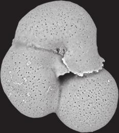
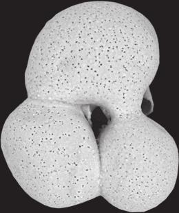
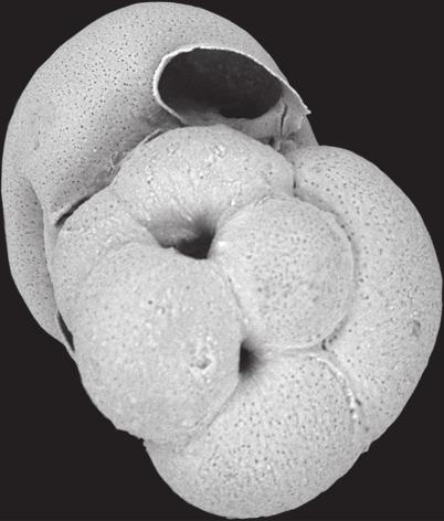
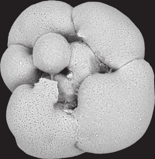
4 196 VAN HENGSTUM AND BERNHARD FIGURE 2. Helenina davescottensis nov. sp. ontogenetic series. 1 4 Proloculus and first chamber. 5 6 Three chambers, ventral view. 7 8 Three chambers, dorsal view. 9 Four chambers, dorsal view. 10 Four chambers, ventral view with large apertural flap. 11 Four chambers, dorsal view with apertures from second and fourth chambers visible. 12 Four chambers, side view emphasizing initiation of trochospiral chamber arrangement. 13 Five chambers, dorsal view. 14 Five chambers, side view with trochospiral character. 15 Five chambers, ventral view with apertures from previous chambers open. 16 Five chambers, side view. 17 Five chambers, dorsal view Six chambers, dorsal view. 22 Six chambers, ventral and side view to emphasize slight trochospiral character and open apertures of previous chambers. 23 Seven chambered individual with wide apertural opening and two supplemental apertures. 24 Eight chambers, but note the inconsistency in the trochospiral coiling in the seventh and eighth chamber to give an almost planispiral appearance. Arrows point to supplementary apertures (19, 23). All specimens are sized proportionally to the scale bars that are located in the corners. Downloaded from
. As such, the chamber arrangement of H.")

. Even juvenile individuals of H.")
, which to our knowledge, have not been described for H. anderseni.")
. Given the taxonomically important features described above, H. davescottensis warrants designation as a new species of foraminifera.")


5 A NEW BRACKISH FORAMINIFERAL SPECIES 197 extending over and covering the umbilical region (see figs. 1C, 3C, 4C in Gennari et al., 2011). In contrast, the flap-like apertural modification in H. davescottensis does partially extend over the umbilical area, just not sufficiently to make the umbilical region involute (Fig. 2.10, 2.15). As such, the chamber arrangement of H. davescottensis is more evolute throughout ontogeny (Fig. 2), and does not achieve a completely involute stage on the umbilical side. The different primary-aperture morphology and supplementary apertures between the two species are also taxonomically significant. First, the interomarginal aperture of H. anderseni extends across the peripheral margin and onto the dorsal side and ventral side where it follows the suture line to create a crescentic to sinuate, slit-like opening into the test. In contrast, additional globular chambers are added in H. davescottensis such that openings on the dorsal side of the test are circular (not sinuate). Even juvenile individuals of H. anderseni retain elongated to sinuate openings on the dorsal surface (see fig. 5 in Gennari et al., 2011), as described for the adults by Loeblich & Tappan (1964). Secondly, H. davescottensis has supplementary apertures on the periphery of final chambers (e.g., Figs. 2.19, 2.24), which to our knowledge, have not been described for H. anderseni. The total number of chambers also differentiates the two species: H. davescottensis typically achieved only 6 7 chambers in the thousands of individuals observed from the type locality, whereas H. anderseni commonly exceeds ten (e.g., Gennari et al., 2011). Given the taxonomically important features described above, H. davescottensis warrants designation as a new species of foraminifera. A reasonable question is whether our multiple geographic observations of H. davescottensis are simply aberrant tests of some other previously described species living in the northern Bahamas, given that benthic foraminifera typically develop test abnormalities in stressed environments such as those with low salinity. However, when foraminifera with test anomalies are encountered, they are typically co-observed with individuals exhibiting a normal external morphology within a pre-existing species concept, even in sinkholes (van Hengstum et al., 2008). No other hyaline foraminifera were observed at the study site and H. davescottensis is characterized by a predictable and repetitive morphology. This is in contrast with the random external morphologies of abnormal foraminiferal tests. It should also be noted that H. anderseni was not observed cohabitating the other localities where H. davescottensis has been observed (Torreblanca Marsh in Spain, and No Man s Land on Abaco Island), which would be expected if the new species described here (H. davescottensis) represented an aberrant morphology of H. anderseni. Furthermore, the observation of H. davescottensis on either side of the North Atlantic in a similar environment (i.e., a marsh habitat flooded by groundwater) does suggest a stabilized phenotype. It remains possible that a microspheric versus FIGURE 3. Other co-occurring microfossils. 1 Centropyxis aculeata var. spinosa. 2 3 Centropyxis constricta var. spinosa. 4 Centropyxis constricta var. aerophila. 5 Jadammina macrescens. 6 7 gyrogonites r from charophtyes. 8 Hydrobia sp. A scale bar is provided for each microfossil group.
6 198 VAN HENGSTUM AND BERNHARD megalospheric relationship (i.e., schizont-gamont dimorphism) may yet be determined between these two different species of Helenina. However, it remains prudent to taxonomically differentiate these individuals for their potential value in reconstructing paleoenvironmental conditions in karst basins until further culturing or molecular systematics work can confidently resolve these issues. Other small rotalids share some characteristics with Helenina davescottensis, but its unique chamber arrangement, supplementary apertures, and aperture structure warrant its designation as a new species. Ammonia tepida (Cushman) is another euryhaline benthic foraminifer that occurs in Caribbean inland sinkholes (van Hengstum et al., 2008). However, even by addition of the third and fourth chamber, the interiormarginal aperture of Ammonia tepida is not covered by a flap-like projection like that of H. davescottensis, and A. tepida does not have supplementary apertures on the dorsal side like H. davescottensis. Nonionella is another common coastal genus that is partially evolute on the spiral side, but this taxon is involute on the umbilical side, and lacks an apertural lip. Metarotaliella simplex (Grell, 1979) is another small rotaliid from marsh-like brackish habitats on carbonate platforms that can easily be confused with H. davescottensis, but the different coiling pattern and grooved umbilical surface in M. simplex clearly differentiates the two. Given the test characteristics of H. davescottensis (e.g., small, thin and fragile, often destroyed through desiccation) and abundance in typically under-sampled environments, we suggest that H. davescottensis has been previously overlooked or that rare individuals have been designated as juveniles of more ubiquitous coastal taxa. The other common smaller benthic foraminifer that occurs in both carbonate sinkholes and caves in Torreblanca Marsh, Spain, is Paraphysalidia paralica (Guillem & Usera, 2012). Paraphysalidia paralica is a small, 3-chambered benthic foraminifer that inhabits oligohaline to mesohaline (1.5 18) conditions, in both modern and fossil settings (Guillem, 2007; Gabriel et al., 2009; Blázquez & Usera, 2010; van Hengstum et al., 2010; and Collins et al., 2015 as Physalidia simplex). It was first observed widely in Torreblanca Marsh, Spain, but has since been observed in Mexican (Yucatan) and Bermudian coastal karst basins. Guillem & Usera (2012) erected the new genus and species because the original hand-drawn holotype of Physalidia simplex Heron-Allen & Earland, which can be viewed in the Ellis and Messina Catalog, is morphologically very different from the individual subsequently imaged by Loeblich and Tappan (1964, 1987). The type locality of Physalidia simplex Heron-Allen & Earland is a shallow marine lagoon in the Pacific Ocean, which has very different environmental conditions from the brackish groundwater habitats where Paraphysalidia paralica is abundant. As such, it is surprising that P. paralica was not observed in the study site, given that P. paralica commonly occurs in oligohaline tropical environments inundated by groundwater. Some still question whether P. paralica represents a juvenile of some pre-existing euryhaline foraminifera. However, Guillem & Usera (2012) clearly imaged a cylindrical or tubular canal between the 2 nd and 3 rd chamber, a taxonomically significant feature that is not observed in other common euryhaline foraminifera such as Ammonia tepida, H. anderseni, or the new H. davescottensis described here (Fig. 2). Ecologically, the other microfossils associated with H. davescottensis in the carbonate marsh suggest that this site remains within the low oligohaline salinity range ( ). However, the absence of other euryhaline foraminifera suggests stressful environmental conditions for these taxa. Although no viability indicator was employed, the ubiquitous presence of H. davescottensis suggests that this species lives in these marsh conditions for at least part of a given year. The only other benthic foraminifer observed at the study site was the rare occurrence of Jadammina macrescens (Brady) (Fig. 3.5). This is somewhat curious considering other euryhaline foraminifera [e.g., Ammonia tepida Cushman, Trichohyalus aguoyi (Bermúdez), Tiphotrocha comprimata (Cushman & Brönnimann), Trochammina inflata (Montagu)] are widely observed in brackish tropical and subtropical sinkholes, caves, mangroves, and ponds (Javaux & Scott, 2003; Roe & Patterson, 2006, van Hengstum et al., 2008; van Hengstum & Scott, 2011). In our samples, three species (or formae) of testate amoebae (i.e., thecamoebians) were observed, all within the same genus: Centropyxis aculeata (Ehrenberg) var. spinosa (Fig. 3A), Centropyxis constricta (Ehrenberg) var. spinosa (Figs. 3B, 3C), and Centropyxis constricta (Ehrenberg) var. aerophila (Fig. 3D). These thecamoebians have been previously observed in Mexican oligohaline sinkholes, but only in sinkholes that are flooded by groundwater with a salinity of less than,3.5 (van Hengstum et al., 2008). Also observed were gyrogonites from charophytes, which are non-marine green algae (Figs. 3F, 3G; Garcia, 1994), and the cosmopolitan freshwater gastropod Hydrobia (Fig. 3H). The occurrence of H. davescottensis could potentially be linked to groundwater conditions, or to an oligohaline carbonate marsh environment. The fact that H. davescottensis was recovered from a sinkhole may only be happenstance, as carbonate marshes need not be confined to a sinkhole basin and typically occur over wider geographic areas. In Spain, the Torreblanca Marsh is constructed upon a Pliocene and Quaternary-aged sedimentary infill, and its hydrology is linked to the Opressa Plain coastal aquifer (Giménez & Morell, 1997). In 1993, the annual temperature, salinity, and ph variability at several locations in Torreblanca Marsh had a range of 10 30uC, psu, and an average ph of , respectively (Guillem, 2007, p ). This is slightly higher salinity than in the Grand Bahamas, but both locales are influenced by groundwater. Lastly, these results suggest that tropical sinkholes with carbonate marshes may provide a modern analog for ancient palustrine outcrops. Additional analysis will be required, however, to answer some of the ecological, environmental and taxonomic questions not resolved here. ACKNOWLEDGMENTS Field support in the Bahamas was provided by Friends of the Environment, The Bahamas Environment, Science and Technology (BEST) Commission of The Ministry of The Environment, T. Winkler, R. Sullivan, and N. Albury, while A. Schulze is thanked for technical support. Fruitful
7 A NEW BRACKISH FORAMINIFERAL SPECIES 199 discussions with M. Buzas and B. Sen Gupta helped clarify some taxonomic points, and thoughtful reviews from S. Spezzaferri and R. Abu-Zied improved the final manuscript. This research was partially supported by NSF awards OCE , OCE , and OCE , and The Investment in Science Fund from Woods Hole Oceanographic Institution (to JMB). REFERENCES Alonso-Zarza, A. M., and Wright, V. P., 2010, Palustrine Carbonates, in Alonso-Zarza, A. M., and Tanner, L. H. (eds.), Carbonates in Continental Settings: Elsevier, Amsterdam, p Alverez Zarikian, C. A., Swart, P. K., Gifford, J. A., and Blackwelder, P. L., 2005, Holocene paleohydrology of Little Salt Spring, Florida, based on ostracod assemblages and stable isotopes: Palaeogeography, Palaeoclimatology, Palaeoecology, v. 225, p Blázquez, A. M., and Usera, J., 2010, Palaeoenvironments and Quaternary foraminifera in the Elx coastal lagoon (Alicante, Spain): Quaternary International, v. 221, p Carew, J. L., and Mylroie, J. E., 1997, Geology of the Bahamas, in Vacher, H. L., and Quinn, T. M. (eds.), Geology and Hydrogeology of Carbonate Islands: Elsevier, Amserdam, p Collins, S. V., Reinhardt, E. G., Rissolo, D., Chatters, J. C., Nava Blank, A., and Luna Erreguerena, P., 2015, Reconstructing water level in Hoyo Negro, Quintana Roo, Mexico, implications for early Paleoamerican and faunal access: Quaternary Science Reviews, v. 124, p Cunliffe, S., 1985, The flora and fauna of Sagittarius, an anchialine cave and lake in Grand Bahama: Cave Science, v. 12, p Gabriel, J. J., Reinhardt, E. G., Peros, M. C., Davidson, D. E., van Hengstum, P. J., and Beddows, P. A., 2009, Palaeoenvironmental evolution of Cenote Aktun Ha (Carwash) on the Yucatan Peninsula, Mexico and its response to Holocene sea-level rise: Journal of Paleolimnology, v. 42, p Garcia, A., 1994, Charophyta: their use in paleolimnology: Journal of Paleolimnology, v. 10, p Gennari, G., Rosenberg, T., Spezzaferri, S., Berger, J.-P., Fleitmann, D., Preusser, F., Al-Shanti, M., and Matter, A., 2011, Faunal evidence of a Holocene pluvial phase in southern Arabia with remarks on the morphological variability of Helenina anderseni: Journal of Foraminiferal Research, v. 41, p Gentry, C. L., and Davis, L. R., 2006, Geomorphological and hydrological controls of freshwater wetlands on San Salvador, Bahamas, in Davis, L. R., and Gamble, D. W., (eds.), Proceedings of the 12 th Symposium on the Geology of the Bahamas and other Carbonate Regions: Gerace Research Center, San Salvador, p Giménez, E., and Morell, I., 1997, Hydrogeochemical analysis of salinization processes in the coastal aquifer of Oropesa (Castellón, Spain): Environmental Geology, v. 29, p Gonzalez, B. C., Iliffe, T. M., Macalady, J. L., Schaperdoth, I., and Kakuk, B., 2011, Microbial hotspots in anchialine blue holes: initial discoveries from the Bahamas: Hydrobiologia, v. 677, p Gonzalez, B. C., Singpiel, A., and Schlagner, P., 2013, Godzillius funchsi, a new species of Remipedia (Godzilliidae) from Abaco Island, Bahamas: Journal of Crustacean Biology, v. 33, p Grell, K. G., 1979, Cytogenetic systems and evolution in foraminifera: Journal of Foraminiferal Research, v. 9, p Guillem, J., 2007, Tafonomía, taxonomía y ecología de los foraminíferos de Torreblanca: PhD Thesis, Universitat de València, 523 p. Guillem, J., and Usera, J., 2012, A new benthic foraminifer from the recent coastal lagoon of Torreblanca (Castellon, Western Mediterranean): Revista Española de Micropaleontología, v. 44, p Harris, J. G., Mylroie, J. E., and Carew, J. L., 1995, Banana Holes: unique karst features of The Bahamas: Carbonates and Evaporites, v. 10, p Iliffe, T. M., Hart, C. W. J., and Manning, R. B., 1983, Biogeography and the caves of Bermuda: Nature, v. 302, p Jaume, D., Iliffe, T. M., and van Der Ham, J. L., 2013, A new Psammogammarus (Amphipoda: Eriopisidae) from anchialine pools on the Exuma Cays, Bahamas: Zootaxa, v. 3700, p Javaux, E., and Scott, D. B., 2003, Illustration of modern benthic foraminifera from Bermuda and remarks on distributions in other subtropical/tropical areas: Paleontologica Electronica, v. 6, p. 29. Kindler, P., and Hearty, P. J., 1997, Geology of the Bahamas: Architechture of Bahamian Islands, in Vacher, H. L., and Quinn, T. (eds.), Geology and Hydrogeology of Carbonate Islands: Elsevier, Amsterdam, p Kjellmark, E., 1996, Late Holocene climate change and human disturbance on Andros Island, Bahamas: Journal of Paleolimnology, v. 15, p Kovacs, S. E., van Hengstum, P. J., Reinhardt, E. G., Donnelly, J. P., and Albury, N. A., 2013, The late Holocene flooding history of Runway Sinkhole: a partially flooded coastal karst basin in the northern Bahamas: Quaternary International, v. 317, p Lane, P., Donnelly, J. P., Woodruff, J. D., and Hawkes, A. D., 2011, A decadally-resolved paleohurricane record archived in the late Holocene sediments of a Florida sinkhole: Marine Geology, v. 287, p Loeblich, A. R. Jr, and Tappan, H., 1964, Sarcodina Chiefly Thecamoebians and Foraminiferida, in Moore, R. C. (ed.), Treatise on Invertebrate Paleontology, Vol. C, Protista 2: Geologic Society of America and University of Kansas Press, Lawrence, Kansas, USA, 900 p. Loeblich, A. R. Jr, and Tappan, H., 1987, Foraminifera Genera and Their Classification: Van Nostrand Reinhold Co., New York, 970 p. (v. 1) pls (v. 2). Maloof, A. C., and Grotzinger, J. P., 2012, The Holocene shallowingupward parasequence of north-west Andros Island, Bahamas, Sedimentology, v. 59, p Melim, L., and Masaferro, J. L., 1997, Geology of the Bahamas: subsurface geology of the Bahamas banks, in Vacher, H. L., and Quinn, T. M. (eds.), Geology and Hydrogeology of Carbonate Islands: Elsevier, Amsterdam, p Meyerhoff, A. A., and Hatten, C. W., 1974, Bahamas salient of North America: tectonic framework, stratigraphy, and petroleum potential: American Association of Petroleum Geologists Bulletin, v. 58, p Milliman, J. D., Freile, D., Steinen, R. P., and Wilber, R. J., 1993, Great Bahama Bank aragonite muds: mostly inorganically precipitated, mostly exported: Journal of Sedimentary Petrology, v. 63, p Monty, C. L. V., 1972, Recent algal stramatolitic deposits, Andros Island, Bahamas, preliminary report: Geologische Rundschau, v. 61, p Monty, C. L. V., and Hardie, L. A., 1976, The geological significance of the freshwater blue-green algal careous marsh, in Walter, M. R., (ed.), Stromatolites, Elsevier, Amsterdam, p Moore, Y. H., Sotessell, R. K., and Easley, D. H., 1992, Fresh-water/ sea-water relationship within a ground-water flow system, northeastern coast of the Yucatan Penisula: Ground Water, v. 30, p Mullins, H. T., and Lynts, G. W., 1977, Origin of the northwestern Bahama Platform: Review and interpretation: Geological Society of America Bulletin, v. 88, p Mylroie, J. E., Carew, J. L., and Moore, A. I., 1995a, Blue holes: definitions and genesis: Carbonates and Evaporites, v. 10, p Mylroie, J. E., Carew, J. L., and Vacher, H. L., 1995b, Karst development in the Bahamas and Bermuda in Curran, H. A., and White, B. (eds.), Terrestrial and Shallow Marine Geology of the Bahamas and Bermuda: Geological Society of America Special Papers v. 300, p Neumann, A. C., and Land, L. S., 1975, Lime mud deposition and calcareous algae in the bight of Abaco, Bahamas: Journal of Sedimentary Petrology, v. 45, p Parker, F. L., 1954, Distribution of the foraminifera in the northeastern Gulf of Mexico: Bulletin of the Museum of Comparative Zoology at Harvard College, v. 111, p. 588.
8 200 VAN HENGSTUM AND BERNHARD Roe, H. M., and Patterson, R. T., 2006, Distribution of thecamoebians (testate amoebae) in small lakes and ponds, Barbados, West Indies: Journal of Foraminiferal Research, v. 36, p Saunders, J. B., 1961, Helenina Saunders, new name for the foraminiferal genus Helenia Saunders, 1957 non Helenia Walcott, 1889: Contributions from the Cushman Foundation for Foraminiferal Research, v. 12, p Sheridan, R. E., Mullins, H. T., Austin, J. A., Jr., Ball, M. M., and Ladd, J. W., 1988, Geology and geophysics of the Bahamas, in Sheridan, R. E., and Grow, J. A. (eds.), The Atlantic Coastal Margin, U.S., The Geology of North America: Geologic Society of America, Boulder, Colorado, p Slayton, I., 2010, A Vegetation History from Emerald Pond, Great Abaco Island, The Bahamas, Based on Pollen Analysis: University of Tennessee, Knoxville, 85 p. Steadman, D. W., Franz, R., Morgan, G. S., Albury, N. A., Kakuk, B., Broad, K., Franz, S. E., Tinker, K., Pateman, M. P., Lott, T. A., Jarzen, D. M., and Dilcher, D. L., 2007, Exceptionally well preserved late Quaternary plant and vertebrate fossils from a blue hole on Abaco, The Bahamas: Proceedings of the National Academy of Sciences, v. 104, p van Hengstum, P. J., and Scott, D. B., 2011, Ecology of foraminifera and habitat variability in an underwater cave: distinguishing anchialine versus submarine cave environments: Journal of Foraminiferal Research, v. 41, p van Hengstum, P. J., and Scott, D. B., 2012, Sea-level rise and coastal circulation controlled Holocene groundwater development and caused a meteoric lens to collapse 1600 years ago in Bermuda: Marine Micropaleonology, v. 90, p van Hengstum, P. J., Reinhardt, E. G., Beddows, P. A., Huang, R. J., and Gabriel, J. J., 2008, Thecamoebians (testate amoebae) and foraminifera from three anchialine cenotes in Mexico: Low salinity ( psu) faunal transitions: Journal of Foraminiferal Research, v. 38, p van Hengstum, P. J., Reinhardt, E. G., Beddows, P. A., Schwarcz, H. P., and Garbriel, J. J., 2009, Foraminifera and testate amoebae (thecamoebians) in an anchialine cave: surface distributions from Aktun Ha (Carwash) cave system, Mexico: Limnology and Oceanography, v. 54, p van Hengstum, P. J., Reinhardt, E. G., Beddows, P. A., and Gabriel, J. J., 2010, Investigating linkages between Holocene paleoclimate and paleohydrogeology preserved in Mexican underwater cave sediments: Quaternary Science Reviews, v. 29, p van Hengstum, P. J., Scott, D. B., Gröcke, D. R., and Charette, M. A., 2011, Sea level controls sedimentation and environments in coastal caves and sinkholes: Marine Geology, v. 286, p Walker, L. N., Mylroie, J. E., Walker, A. D., and Mylroie, J. R., 2008, The caves of Abaco Island, Bahamas: Keys to geologic timelines: Journal of Cave and Karst Studies, v. 70, p Warren, A. D., 1957, Foraminifera of the Buras-Scofield Bayou region, southeast Louisiana: Contributions from the Cushman Foundation for Foraminiferal Research, v. 8, p Whitaker, F. F., and Smart, P. L., 1997, Groundwater circulation and geochemistry of a karstified bank-marginal fracture system, South Andros Island, Bahamas: Journal of Hydrology, v. 197, p Received 13 July 2015 Accepted 5 October 2015
Lake Levels and Climate Change in Maine and Eastern North America during the last 12,000 years
 Maine Geologic Facts and Localities December, 2000 Lake Levels and Climate Change in Maine and Eastern North America during the last 12,000 years Text by Robert A. Johnston, Department of Agriculture,
Speleogenesis and Evolution of Karst Aquifers
 Speleogenesis and Evolution of Karst Aquifers Issue 11, 2011 Kristin N. Kelley 1, John E. Mylroie 1 *, Joan R. Mylroie 1, Christopher M. Moore 1, Laura R. Collins 1, Lica Ersek 1, Ioan Lascu 1, Monica
Peter J. van Hengstum
 Peter J. van Hengstum vanhenp@tamug.edu Department of Marine Sciences! Texas A&M University at Galveston! Galveston! Texas! 7755 Department of Oceanography! Texas A&M University! College Station! Texas!
Long-Term Patterns of Coastal Response to Changing Land Use and Climate: Examples from the Atlantic and Gulf Coastal Plains
 Long-Term Patterns of Coastal Response to Changing Land Use and Climate: Examples from the Atlantic and Gulf Coastal Plains Debra Willard, Christopher Bernhardt, and Miriam Jones U.S. Geological Survey,
Case Study of the Structural and Depositional-Evolution Interpretation from Seismic Data*
 Case Study of the Structural and Depositional-Evolution Interpretation from Seismic Data* Yun Ling 1, Xiangyu Guo 1, Jixiang Lin 1, and Desheng Sun 1 Search and Discovery Article #20143 (2012) Posted April
9 th INTECOL Orlando, Florida June 7, 2012
 Restoration of the Everglades Saline Wetlands and Florida Bay: Responses Driven from Land and Sea David Rudnick 1, Colin Saunders 2, Carlos Coronado 2, Fred Sklar 2 Erik Stabenau 1, Vic Engel 1, Rene Price
CHAPTER 6 & 7 VOCABULARY
 CHAPTER 6 & 7 VOCABULARY 1. Biome 2. Climate 3. Latitude 4. Altitude 5. Emergent layer 6. Epiphyte 7. Understory 8. Permafrost 9. Wetland 10.Plankton 11.Nekton 12.Benthos 13.Littoral zone 14.Benthic zone
PARETO ANALYSIS OF PALEONTOLOGICAL DATA: A NEW METHOD OF WEIGHING VARIABLE IMPORTANCE
 Abstract: Pareto Analysis of Paleontological Data: A New Method of Weighing Variable Importance PARETO ANALYSIS OF PALEONTOLOGICAL DATA: A NEW METHOD OF WEIGHING VARIABLE IMPORTANCE and ABSTRACT Pareto
Holocene evolution of Dahab coastline Gulf of Aqaba, Sinai Peninsula, Egypt 1
 Holocene evolution of Dahab coastline Gulf of Aqaba, Sinai Peninsula, Egypt 1 Magdy Torab* 2 * Prof. of Geomorphology, Department of Geography, Damanhour University, Egypt 3 E-mail: magdytorab@hotmail.com.
Sequence Stratigraphy as a tool for water resources management in alluvial coastal aquifers: application to the Llobregat delta (Barcelona, Spain)
") Sequence Stratigraphy as a tool for water resources management in alluvial coastal aquifers: application to the Llobregat delta (Barcelona, Spain) Desiré Gàmez Torrent December 2007 CHAPTER 1: Introduction
Sequence Stratigraphy as a tool for water resources management in alluvial coastal aquifers: application to the Llobregat delta (Barcelona, Spain) Desiré Gàmez Torrent December 2007 CHAPTER 1: Introduction
Last Time. Submarine Canyons and Fans. Turbidites. MAS 603: Geological Oceanography. Lecture 16: Greenhouse vs. Icehouse Earths
 UNIVERSITY OF SOUTH ALABAMA Last Time MAS 603: Geological Oceanography Lecture 16: Greenhouse vs. Icehouse Earths Submarine Fans Definition and morphology Transport mechanisms (density currents) Submarine
The Impact of Changing Winds on Estuarine Evolution, Copano Bay, TX
 The Impact of Changing Winds on Estuarine Evolution, Copano Bay, TX Purpose: The fulfillment of partial requirements for the Degree of Master of Science in Geology Oklahoma State University, Stillwater
Chapter 4 Implications of paleoceanography and paleoclimate
 Age ka / Chapter 4 Implications of paleoceanography and paleoclimate 4.1 Paleoclimate expression 4.2 Implications of paleocirculation and tectonics 4.3 Paleoenvironmental reconstruction MD05-2901 (Liu
Lab 7: Sedimentary Structures
 Name: Lab 7: Sedimentary Structures Sedimentary rocks account for a negligibly small fraction of Earth s mass, yet they are commonly encountered because the processes that form them are ubiquitous in the
Types of Wetlands. Tidal Systems
 Types of Wetlands Tidal Systems 1 COASTAL WETLAND ECOSYSTEMS Tidal Salt Marshes Tidal Freshwater Marshes Mangrove Wetlands 2 Tidal Estuarine Wetland 3 Definition and Formation of Estuaries Estuary: : partially
Subtidal permanently flooded with tidal water. Irregularly exposed surface exposed by tides less often than daily
 Types of Wetlands Tidal Systems COASTAL WETLAND ECOSYSTEMS Tidal Salt Marshes Tidal Freshwater Marshes Mangrove Wetlands Tidal Estuarine Wetland 1 Definition and Formation of Estuaries u Estuary : partially
GLY Coastal Geomorphology Notes
 GLY 4734 - Coastal Geomorphology Notes Dr. Peter N. Adams Spring 2011 2 Coastal Classification In this lecture, we discuss some successful classification schemes of the coastal landscape, and pay particular
EARTH SURFACE PROCESSES AND SEDIMENTATION!
 Sed and Strat EARTH SURFACE PROCESSES AND SEDIMENTATION! 2/27 Lecture 7- Exposure: Weathering and the Sediment Factory 3/04 Lecture 8 - Rivers and Landscapes 3/06 Lecture 9 - Waves (not Tides) 3/11 Lecture
Facies Reconstruction of a Late Pleistocene Cypress Forest Discovered on the Northern Gulf of Mexico Continental Shelf
 Facies Reconstruction of a Late Pleistocene Cypress Forest Discovered on the Northern Gulf of Mexico Continental Shelf Suyapa Gonzalez 1, Samuel J. Bentley, Sr. 1, Kristine L. DeLong 3, Kehui Xu 2, Jeffrey
Environmental Science
 Environmental Science A Study of Interrelationships Cui Jiansheng Hebei University of Science and Technology CH06 Kinds of Ecosystems and Communities Chapter Objectives After reading this chapter, you
Paleo Lab #4 - Sedimentary Environments
 Paleo Lab #4 - Sedimentary Environments page - 1. CHARACTERISTICS OF SEDIMENT Grain size and grain shape: The sizes and shapes of sedimentary particles (grains) are modified considerably during their transportation
The Montauk Peninsula: Data and Preliminary Interpretations of the Ditch Plains Area Introduction
 The Montauk Peninsula: Data and Preliminary Interpretations of the Ditch Plains Area John A. Black GSI Patchogue, New York R.S. Welch Suffolk Community College Selden, New York Introduction Sirkin, (1982)
Evaluation of the hydraulic gradient at an island for low-level nuclear waste disposal
 A New Focus on Groundwater Seawater Interactions (Proceedings of Symposium HS1001 at IUGG2007, Perugia, July 2007). IAHS Publ. 312, 2007. 237 Evaluation of the hydraulic gradient at an island for low-level
Physiographic Provinces (West, Ch. 13)
") Geology 229 Engineering Geology Lecture 13 Physiographic Provinces (West, Ch. 13) The definition of the term Physiography Physiography (n.) The science which treats of the earth's exterior physical features,
Geology 229 Engineering Geology Lecture 13 Physiographic Provinces (West, Ch. 13) The definition of the term Physiography Physiography (n.) The science which treats of the earth's exterior physical features,
American Harris mud crab Rhithropanopeus harrisii
 American Harris mud crab Rhithropanopeus harrisii (Gould, 1841) in the Gulf of Gdańsk (southern Baltic Sea): distribution, population structure and basic physiological processes Joanna Hegele-Drywa Alien
PETROGLYPHS OF THE BAHAMAS. John H. Winter INTRODUCTION
 PETROGLYPHS OF THE BAHAMAS John H. Winter INTRODUCTION For at least 500 years, the Bahamas Archipelago was occupied by Amerindian populations who migrated from the Greater Antilles region. These frontier
2013 SCEC Annual Report
 2013 SCEC Annual Report Collaborative research: Documentation of Tsunami Deposits in the Carpinteria Estuary: A signal of Great Earthquakes on the Pitas Point Thrust L. Reynolds, A. Simms, T.K. Rockwell,
THE MICROBIAL PEDIGREE OF FRESHWATER MARL: TRACKING TEXTURES THROUGH EARLY BURIAL AND DIAGENESIS
 Chelsea is a graduate student at the RSRM at the University of Miami; she is currently working on her PhD degree in geomicrobiology. THE MICROBIAL PEDIGREE OF FRESHWATER MARL: TRACKING TEXTURES THROUGH
Drifting Continents and Spreading Seas. The Road To Plate Tectonics
 Drifting Continents and Spreading Seas The Road To Plate Tectonics Alfred Wegener and the Continental Drift hypothesis: Up until the early 1900s, long-held tradition in the earth sciences stated that continents
Coastal Oceanography. Coastal Oceanography. Coastal Waters
 Coastal Oceanography Coastal Oceanography 95% of ocean life is in coastal waters (320 km from shore) Estuaries and wetlands are among most productive ecosystems on Earth Major shipping routes, oil and
MARINE GEOLOGY & GEOGRAPHY
 MARINE GEOLOGY & GEOGRAPHY Bathymetry BATHYMETRY BATHYMETRY THE UNDERWATER EQUIVALENT TO TOPOGRAPHY THE STUDY OF WATER DEPTH A BATHYMETRIC MAP SHOWS FLOOR RELIEF OR TERRAIN AS CONTOUR LINES Bathymetry
Diagenetic processes in the Cenozoic sedimentary formations associated with the Chicxulub Impact Crater, northwestern Yucatan Peninsula, Mexico
 The Second International Conference on Saltwater Intrusion and Coastal Aquifers Monitoring, Modeling, and Management. Mérida, Yucatán, México, March 30 - April 2, 2003 Diagenetic processes in the Cenozoic
Semi-enclosed seas. Estuaries are only a particular type of semi-enclosed seas which are influenced by tides and rivers
 Semi-enclosed seas Estuaries are only a particular type of semi-enclosed seas which are influenced by tides and rivers Other semi-enclosed seas vary from each other, mostly by topography: Separated from
5 Year B.S/M.S. Program in Geological Sciences and Marine Geosciences
 Geological Sciences 1 GEOLOGICAL SCIENCES Dept. Code: GSC Geological Sciences Geological Sciences is concerned with Planet Earth, its origin, evolution, structure, internal and surface processes, mineral
Lecture Outlines PowerPoint. Chapter 12 Earth Science 11e Tarbuck/Lutgens
 Lecture Outlines PowerPoint Chapter 12 Earth Science 11e Tarbuck/Lutgens 2006 Pearson Prentice Hall This work is protected by United States copyright laws and is provided solely for the use of instructors
Rockall Plateau. OCN 201: Shelf Sediments
 Rockall Plateau OCN 201: Shelf Sediments Classification by Size Classification by Mode of Formation Detrital sediments Transported and deposited as particles Derived from weathering of pre-existing rocks
ATOC OUR CHANGING ENVIRONMENT
 ATOC 1060-002 OUR CHANGING ENVIRONMENT Class 22 (Chp 15, Chp 14 Pages 288-290) Objectives of Today s Class Chp 15 Global Warming, Part 1: Recent and Future Climate: Recent climate: The Holocene Climate
24. Ocean Basins p
 24. Ocean Basins p. 350-372 Background The majority of the planet is covered by ocean- about %. So the majority of the Earth s crust is. This crust is hidden from view beneath the water so it is not as
Marl Prairie vegetation response to 20th century land use and its implications for management in the Everglades
 Marl Prairie vegetation response to 20th century land use and its implications for management in the Everglades C. Bernhardt, D. Willard, B. Landacre US Geological Survey Reston, VA USA U.S. Department
STOP 5: GINGERBREAD CASTLE STROMATOLITES, HAMBURG, NJ
 Contributions to the Paleontology of New Jersey (II) STOP 5: GINGERBREAD CASTLE STROMATOLITES, HAMBURG, NJ Deborah Freile 1, Emma C. Rainforth 2, and Gregory Herman 3 1 Department of Geoscience and Geography,
Module 3. Basic Ecological Principles
 Module 3. Basic Ecological Principles Ecosystem Components Abiotic Biotic Species & Habitat The Biomes of North America Communities Energy & Matter Cycles in Ecosystems Primary Productivity Simple Ecosystem
THE ROLE OF MICROPALEONTOLOGY IN ASSISTING WITH THE CHARACTERIZATION OF THE GEOLOGY BENEATH FAILED NEW ORLEANS LEVEES, LOUISIANA
 THE ROLE OF MICROPALEONTOLOGY IN ASSISTING WITH THE CHARACTERIZATION OF THE GEOLOGY BENEATH FAILED NEW ORLEANS LEVEES, LOUISIANA Conor Watkins J. David Rogers Francisca Oboh-Ikuenobe Geological Sciences
 12 10 8 6 4 2 0 40-50 50-60 60-70 70-80 80-90 90-100 Fresh Water What we will cover The Hydrologic Cycle River systems Floods Groundwater Caves and Karst Topography Hot springs Distribution of water in
A) B) C) D) 4. Which diagram below best represents the pattern of magnetic orientation in the seafloor on the west (left) side of the ocean ridge?
 B) C) D) 4. Which diagram below best represents the pattern of magnetic orientation in the seafloor on the west (left) side of the ocean ridge?") 1. Crustal formation, which may cause the widening of an ocean, is most likely occurring at the boundary between the A) African Plate and the Eurasian Plate B) Pacific Plate and the Philippine Plate C)
1. Crustal formation, which may cause the widening of an ocean, is most likely occurring at the boundary between the A) African Plate and the Eurasian Plate B) Pacific Plate and the Philippine Plate C)
Introduction After reviewing the classification of continental margins (not plate margins) in your textbook, answer the following questions:
 in your textbook, answer the following questions:") Investigating the continental margins of North America using GeoMapApp. This exercise is designed to familiarize you with the features of continental margins. Through the analysis of color-coded bathymetric
Investigating the continental margins of North America using GeoMapApp. This exercise is designed to familiarize you with the features of continental margins. Through the analysis of color-coded bathymetric
Quiz 12 Bonus 2 (9:30-9:35 AM)
") Quiz 12 Bonus 2 (9:30-9:35 AM) UNIVERSITY OF SOUTH ALABAMA GY 112: Earth History Lectures 32 and 33: Mesozoic Sedimentation Instructor: Dr. Douglas W. Haywick Last Time Mesozoic Tectonics A) The Triassic
Quiz 12 Bonus 2 (9:30-9:35 AM) UNIVERSITY OF SOUTH ALABAMA GY 112: Earth History Lectures 32 and 33: Mesozoic Sedimentation Instructor: Dr. Douglas W. Haywick Last Time Mesozoic Tectonics A) The Triassic
Biostratigraphic and Lithostratigraphic Correlation of Sedimentary Strata in the Atlantic Coastal Plain
 Biostratigraphic and Lithostratigraphic Correlation of Sedimentary Strata in the Atlantic Coastal Plain Introduction to the Atlantic Coastal Plain (Please read this page prior to doing the lab) The Atlantic
\\ \\,. 5 'l.o\\).. S~O\...E
.. S~O\...E") Journal of Foraminiferal Research, v. 41, no. 3, p. 1-229, July 11 ECOLOGY OF FORAMINIFERA AND HABITAT VARIABILITY IN AN UNDERWATER. CAVE: DISTINGUISHING ANCHIALINE VERSUS SUBMARINE CAVE ENVIRO:~~ ~~p{a(\/
Journal of Foraminiferal Research, v. 41, no. 3, p. 1-229, July 11 ECOLOGY OF FORAMINIFERA AND HABITAT VARIABILITY IN AN UNDERWATER. CAVE: DISTINGUISHING ANCHIALINE VERSUS SUBMARINE CAVE ENVIRO:~~ ~~p{a(\/
Supplementary Figure 1. New downcore data from this study. Triangles represent the depth of radiocarbon dates. Error bars represent 2 standard error
 Supplementary Figure 1. New downcore data from this study. Triangles represent the depth of radiocarbon dates. Error bars represent 2 standard error of measurement (s.e.m.). 1 Supplementary Figure 2. Particle
Ms. A. Mormando's Class *
 8 th Grade Science Essential Standard: 8.E.1.1 Explain the structure of the hydrosphere including: Water distribution on Earth; Local river basin and water availability Stream - A stream is a body of water
GEOLOGY MEDIA SUITE Chapter 5
 UNDERSTANDING EARTH, SIXTH EDITION GROTZINGER JORDAN GEOLOGY MEDIA SUITE Chapter 5 Sedimentation Rocks Formed by Surface Processes 2010 W.H. Freeman and Company Mineralogy of sandstones Key Figure 5.12
Pre-Lab Reading Questions ES202
 ES202 The are designed to encourage students to read lab material prior to attending class during any given week. Reading the weekly lab prior to attending class will result in better grade performance
Sea Level Rise in Miami-Dade County Florida Implications for Management of Coastal Wetlands and the Everglades
 Sea Level Rise in Miami-Dade County Florida Implications for Management of Coastal Wetlands and the Everglades Peter W. Harlem Dr. John F. Meeder Florida International University Southeast Environmental
Chapter 2: Plate Tectonics: A Unifying Theory
 Chapter 2: Plate Tectonics: A Unifying Theory Chapter Outline 2.1 Introduction 2.2 Early Ideas About Continental Drift 2.3 What Is the Evidence for Continental Drift? 2.4 Features of the Seafloor 2.5 Earth
3. The diagram below shows how scientists think some of Earth's continents were joined together in the geologic past.
 1. The map below shows the present-day locations of South America and Africa. Remains of Mesosaurus, an extinct freshwater reptile, have been found in similarly aged bedrock formed from lake sediments
Coastal and Marine Ecological Classification Standard (CMECS)
") Coastal and Marine Ecological Classification Standard (CMECS) Mark Finkbeiner NOAA Coastal Services Center Presented at the International Workshop on Seabed Mapping Methods and Technology 18 October 2012
Coastal and Marine Ecological Classification Standard (CMECS) Mark Finkbeiner NOAA Coastal Services Center Presented at the International Workshop on Seabed Mapping Methods and Technology 18 October 2012
CHAPTER 1 INTRODUCTION
 1 CHAPTER 1 INTRODUCTION 1.1 GENERAL Washover sandsheets are often found in low-lying coastal embayment s (Sedgwick and Davis 2003). Washover deposition of marine sand is usually attributed to storm activity
PALEOHYDROLOGIC RECONSTRUCTION OF YAX CHEN CAVE (YUCATAN PENINSULA, MEXICO) IN RESPONSE TO HOLOCENE CLIMATE CHANGE. By Winnie May Chan, B.A. (HONS.
 IN RESPONSE TO HOLOCENE CLIMATE CHANGE. By Winnie May Chan, B.A. (HONS.") PALEOHYDROLOGIC RECONSTRUCTION OF YAX CHEN CAVE (YUCATAN PENINSULA, MEXICO) IN RESPONSE TO HOLOCENE CLIMATE CHANGE By Winnie May Chan, B.A. (HONS.) A Thesis Submitted to the School of Geography and Earth
PALEOHYDROLOGIC RECONSTRUCTION OF YAX CHEN CAVE (YUCATAN PENINSULA, MEXICO) IN RESPONSE TO HOLOCENE CLIMATE CHANGE By Winnie May Chan, B.A. (HONS.) A Thesis Submitted to the School of Geography and Earth
Earth s Continents and Seafloors. GEOL100 Physical Geology Ray Rector - Instructor
 Earth s Continents and Seafloors GEOL100 Physical Geology Ray Rector - Instructor OCEAN BASINS and CONTINENTAL PLATFORMS Key Concepts I. Earth s rocky surface covered by of two types of crust Dense, thin,
Brief report on Belize carbonate environments field trip Feb. 2012
 Brief report on Belize carbonate environments field trip Feb. 2012 In february 2012 I travelled to San Pedro (Ambergris Caye) Belize (Figure 1) to examine and study depositional environments of carbonate
Ch. 17 Review. Life in the Cretaceous
 Ch. 17 Review Life in the Cretaceous Diversification of diatoms, planktonic forams, calcareous nannoplankton Diversification of mobile predators (especially mollusks and teleost fishes) Origin of the angiosperms
Akita, L.G., 1 Frenzel, P., 2 Haberzettl, T., 2 Kasper, T. 2 Wang, J., 3 Peng, P., 3
 OSTRACODA AS PALAEO-ENVIRONMENT INDICATORS Akita, L.G., 1 Frenzel, P., 2 Haberzettl, T., 2 Kasper, T. 2 Wang, J., 3 Peng, P., 3 1 University of Ghana 2 Friedrich-Schiller-Universität Jena,Germany 3 Chinese
MEMORANDUM FOR SWG
 MEMORANDUM FOR SWG-2007-1623 Subject: Jurisdictional Determination (JD) for SWG-2007-1623 on Interdunal Wetlands Adjacent to Traditional Navigable Waters (TNWs) Summary The U.S. Environmental Protection
2 Georgia: Its Heritage and Its Promise
 TERMS region, erosion, fault, elevation, Fall Line, aquifer, marsh, climate, weather, precipitation, drought, tornado, hurricane, wetland, estuary, barrier island, swamp PLACES Appalachian Mountains, Appalachian
Literature 2/25/2009 ISOTOPES. Peter Swart University of Miami. A Short Course VU March, 2009
 Literature A Short Course VU March, 2009 Peter Swart University of Miami Arthur M., Anderson T., Kaplan I., Veizer J., and Land L. (1983) Stable Isotopes in Sedimentary Geology, SEPM Short Course No 10.
Studies on adaptation capacity of Carpathian ecosystems/landscape to climate change
 ` Studies on adaptation capacity of Carpathian ecosystems/landscape to climate change Science for the Carpathians CARPATHIAN CONVENTION COP5 Lillafüred, 10.10.2017-12.10.2017 Marcel Mîndrescu, Anita Bokwa
OSTRACODES AS PROXIES FOR PALEOSALINITY IN BAYS OF VIEQUES, PUERTO RICO
 OSTRACODES AS PROXIES FOR PALEOSALINITY IN BAYS OF VIEQUES, PUERTO RICO LAURA R. ROBERTSON The College of William and Mary Dr. Heather Macdonald and Dr. Neil Tibert INTRODUCTION The 2006 Keck Geology Consortium
Karst found mostly in limestone (rock with at least 50% carbonate minerals), depends on 1) permeability & porosity
, depends on 1) permeability & porosity") KARST LANDFORMS produced by weathering & erosion in regions of carbonate rocks and evaporites processes called karstification mainly below ground surface predominantly underground drainage poorly-developed
KARST LANDFORMS produced by weathering & erosion in regions of carbonate rocks and evaporites processes called karstification mainly below ground surface predominantly underground drainage poorly-developed
Expanding the western Mediterranean Holocene relative sea-level records: new data from Balearic, Corsica and Sardinia Islands
 Expanding the western Mediterranean Holocene relative sea-level records: new data from Balearic, Corsica and Sardinia Islands Roma, 05-07-2018 Matteo Vacchi Lecturer at the College of Life and Environmental
Florida s Changing Shape
 Florida s Changing Shape Background: For much of its history, Florida was underwater. At first, Florida consisted solely of the Florida Platform, a limestone base formed from the calcium carbonate remains
The United States & Canada. A Regional Study of Anglo America
 A Regional Study of Anglo America Landform Regions of the United States & Canada world leaders in agricultural and industrial production because of... VAST LANDS stretch from the Atlantic Ocean on the
ESS Scope and Sequence
 ESS Scope and Sequence Grading Unit Title Learning Targets Throughout the School Year (1) Scientific processes. The student conducts laboratory and field investigations, for at least 40% of instructional
ENVIRONMENTAL GEOSCIENCE UNIFORM SYLLABUS
 ENVIRONMENTAL GEOSCIENCE UNIFORM SYLLABUS The Association of Professional Engineers and Geoscientists of the Province of British Columbia Note: 1. This Syllabus May Be Subject To Change 2. These Courses
Holocene Lower Mississippi River Avulsions: Autogenic Versus Allogenic Forcing*
 Holocene Lower Mississippi River Avulsions: Autogenic Versus Allogenic Forcing* Eric Prokocki 1,2 Search and Discovery Article #50330 (2010) Posted October 14, 2010 *Adapted from oral presentation at AAPG
14. GROWTH STUDIES ON GLOBOROTALIA EXILIS BLOW AND GLOBOROTALIA PERTENIUS BEARD IN THE HOLE 154A SECTION, LEG 15, DEEP SEA DRILLING PROJECT
 14. GROWTH STUDIES ON GLOBOROTALIA EXILIS BLOW AND GLOBOROTALIA PERTENIUS BEARD IN THE HOLE 154A SECTION, LEG 15, DEEP SEA DRILLING PROJECT Richard K. Olsson, Geology Department, Rutgers University, New
Bahamian Dolomites. Occurrences in the Bahamas 2/25/2009. Platform Dolomites. Cretaceous Dolomite. San Salvador Little Bahama Bank.
 Bahamian Dolomites A Short Course VU March, 2009 Peter Swart University of Miami Occurrences in the Bahamas Platform Dolomites San Salvador Little Bahama Bank Bahamas Drilling Project Unda Clino Cretaceous
Depositional Environments. Depositional Environments
 Depositional Environments Geographic area in which sediment is deposited Characterized by a combination of geological process & environmental conditions Depositional Environments Geological processes:
Regional-scale understanding of the geologic character and sand resources of the Atlantic inner continental shelf, Maine to Virginia
 Regional-scale understanding of the geologic character and sand resources of the Atlantic inner continental shelf, Maine to Virginia Workshop on Dredging, Beach Nourishment and Bird Conservation Atlantic
Developed in Consultation with Florida Educators
 Developed in Consultation with Florida Educators Table of Contents Next Generation Sunshine State Standards Correlation Chart... 7 Benchmarks Chapter 1 The Practice of Science...................... 11
Sequence Stratigraphy of the Upper Cretaceous Niobrara Formation, A Bench, Wattenberg Field, Denver Julesburg Basin, Colorado*
 Sequence Stratigraphy of the Upper Cretaceous Niobrara Formation, A Bench, Wattenberg Field, Denver Julesburg Basin, Colorado* Lisa E. Remington LaChance 1 and Mark C. Robinson 1 Search and Discovery Article
Optimal Design of Sediment Diversions for Delta Restoration: lessons learned from examples
 Optimal Design of Sediment Diversions for Delta Restoration: lessons learned from examples Samuel Bentley 1, Angelina Freeman 2, Clinton S. Willson 1, Liviu Giosan 3, Jaye Cable 4 1 LSU 2 EDF 3 WHOI 4
The Geology of Sebago Lake State Park
 Maine Geologic Facts and Localities September, 2002 43 55 17.46 N, 70 34 13.07 W Text by Robert Johnston, Department of Agriculture, Conservation & Forestry 1 Map by Robert Johnston Introduction Sebago
Carbonate Diagenesis. M.Geo.136b, Applications in hydrocarbon exploration Saskia Köhler, Patrick Ahlers
 Carbonate Diagenesis M.Geo.136b, Applications in hydrocarbon exploration Saskia Köhler, Patrick Ahlers Carbonate in general 3 main components: 1) carbonate grains (aragonite, high- /low-mg calcite), 2)
Ecoregions Glossary. 7.8B: Changes To Texas Land Earth and Space
 Ecoregions Glossary Ecoregions The term ecoregions was developed by combining the terms ecology and region. Ecology is the study of the interrelationship of organisms and their environments. The term,
The development of palaeotsunami research
 The development of palaeotsunami research Sahra Skripsky, Undergraduate Student, Dalhousie University Abstract Over the last thirty years, the study of palaeotsunamis has received increasing attention.
Directed Reading. Section: The Water Planet. surface is called the a. Earth s ocean. b. Pacific Ocean. c. salt-water ocean. d. global ocean.
 Skills Worksheet Directed Reading Section: The Water Planet 1. The body of salt water covering nearly three-quarters of the Earth s surface is called the a. Earth s ocean. b. Pacific Ocean. c. salt-water
High tide dispersion of marine benthic foraminifera into brackish waters: implications for dispersion processes during sea-level rise
 Laguna (2010) 17: 15-21 ISSN 2185-2995 High tide dispersion of marine benthic foraminifera into brackish waters: implications for dispersion processes during sea-level rise Ritsuo Nomura 1 Koji Seto 2
Ecosystem History of Florida Bay and the Southern Estuaries Five Year Update. G. Lynn Wingard (USGS)
") Ecosystem History of Florida Bay and the Southern Estuaries Five Year Update G. Lynn Wingard (USGS) Progress since 2003 Florida Bay Science Conference Expansion of Ecosystem History Research into surrounding
Ecosystem History of Florida Bay and the Southern Estuaries Five Year Update G. Lynn Wingard (USGS) Progress since 2003 Florida Bay Science Conference Expansion of Ecosystem History Research into surrounding
Plan of Development Mountain Valley Pipeline Project. APPENDIX P Plan for Unanticipated Discovery of Paleontological Resources
 APPENDIX P Plan for Unanticipated Discovery of Paleontological Resources Appendix P Plan for Unanticipated Discovery of Paleontological Resources Prepared by: TABLE OF CONTENTS 1.0 INTRODUCTION... 1 1.1
GY 111 Lecture Note Series Sedimentary Environments 4: Carbonates
 GY 111 Lecture Notes D. Haywick (2008-09) 1 Lecture Goals A) Shelf Terminology B) Reefs, atolls and oolites C) Evaporites and evaporate basins GY 111 Lecture Note Series Sedimentary Environments 4: Carbonates
Geologic Trips San Francisco and the Bay Area
 Excerpt from Geologic Trips San Francisco and the Bay Area by Ted Konigsmark ISBN 0-9661316-4-9 GeoPress All rights reserved. No part of this book may be reproduced without written permission in writing,
Bulletin of Earth Sciences of Thailand
 Depositional Environments and Stratigraphic Development of the Grand Taman Sari Circuit Outcrop: an Analogue for Transgressive Mahakam Delta Successions Ridha Santika Riadi Petroleum Geoscience Program,
Forecast of Nearshore Wave Parameters Using MIKE-21 Spectral Wave Model
 Forecast of Nearshore Wave Parameters Using MIKE-21 Spectral Wave Model Felix Jose 1 and Gregory W. Stone 2 1 Coastal Studies Institute, Louisiana State University, Baton Rouge, LA 70803 2 Coastal Studies
Reading Material. See class website. Sediments, from Oceanography M.G. Gross, Prentice-Hall
 Reading Material See class website Sediments, from Oceanography M.G. Gross, Prentice-Hall Materials filling ocean basins Dissolved chemicals especially from rivers and mid-ocean ridges (volcanic eruptions)
Education Brown University Geological Sciences Ph.D., 2001 Brown University Geological Sciences Sc.M., 1997 The Colorado College Geology B.A.
 University of Minnesota Department of Geography 414 Social Science Building Minneapolis MN 55455 Bryan N. Shuman Assistant Professor Phone: 612-625-8591 Fax: 612-624-1044 E-mail: bshuman@umn.edu Education
The Geology of Cobscook Bay State Park
 Maine Geologic Facts and Localities August, 2000 44 50 24.67 N, 67 9 3.01 W Text by Robert A. Johnston, Department of Agriculture, Conservation & Forestry 1 Map by USGS Introduction Cobscook Bay State
GEOCHEMISTRY UNIFORM SYLLABUS
 GEOCHEMISTRY UNIFORM SYLLABUS The Association of Professional Engineers and Geoscientists of the Province of British Columbia Note: 1. This Syllabus May Be Subject To Change 2. These Courses Are Required
The 1700/01/26 Cascadia subduction zone Earthquake and Tsunami
 Jason R. Patton GEO 142 1/13/15 Abstract: Cascadia subduction zone earthquakes (CSZ) can generate strong ground shaking and deadly tsunamis. Geologists used sediment cores and stream bank exposures to
Deep sea floor By. The structures and features of ocean basin are summarized in Fig. 1. Ocean basin
 Deep sea floor By Sufia Zaman 1, Tanmay Ray Chaudhuri 2, Prosenjit Pramanick 2 and Abhijit Mitra 1 1 Department of Marine Science, University of Calcutta, 35, B. C. Road, Kolkata-700 019, India. 2 Department
Everglades National Park
 National Park Service U.S. Department of the Interior Climate Variability and the Coastal Physical Environment (Florida Bay) Presented by: Erik Stabenau - National Park Service Contributions from: Christina