TECHNICAL REPORT. JUDY 1 (tenure no ) MCDAME MTN (tenure no ) LIARD MINING DIVISION BRITISH COLUMBIA, CANADA NTS 104P
|
|
|
- Theodore Shields
- 5 years ago
- Views:
Transcription
1 TECHNICAL REPORT JUDY 1 tenure no ) MCDAME MTN tenure no ) LIARD MINING DIVISION BRITISH COLUMBIA, CANADA NTS 104P UTM Zone 9) E, N Event No Owner: Operator: Stephen Gerald Gerry) Diakow Farshad Shirvani, MSc. Date of Report: October 3, 2012.
2 Contents 1.0 INTRODUCTION STRUCTURAL STUDY STATEMENT OF QUALIFICATIONS COST STATEMENT... 2 List of Figures Figure 1: Project Location in BC... 3 Figure 2: Tenure Map... 4 Figure 3: Geology Map... 5 Figure 4: Hill Shade Imagery Azimuth 0 Direction... 6 Figure 5: Hill Shade Imagery Azimuth 45 Direction... 7 Figure 6: Hill Shade Imagery Azimuth 90 Direction... 8 Figure 7a-d): Lineaments Statistics... 9
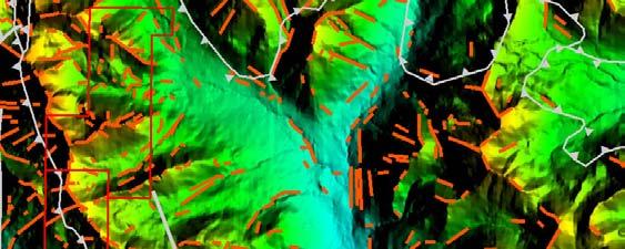
3 1.0 INTRODUCTION The Judy 1 and McDame Mtn mineral tenures, located from three to six km northeast of Cassiar townsite, northwestern British Columbia, Canada Figures 1 and 2) comprise 413 ha and ha respectively. They lie on the east flank of McDame Mountain of the Cassiar Ranges, at the headwaters area of several small northeast flowing tributaries of Quartz Creek. Elevations vary from 1220 to 2070 metres 4000 to 6800 feet) a.s.l. The terrain is entirely alpine with steep slopes and few evergreen trees. The tenures may be accessed from the valley of Quartz Creek but fieldwork, for practical purposes, is likely to require helicopter support. The mineral tenures are held by Stephen Gerry Diakow of Tsawwassen, B.C. and are situated immediately east of the former Cassiar mine. In addition to the Cassiar mine, the district is host to a broad range of mineral deposits, including significant but non-economic molybdenum, tungsten, gold, silver, lead, zinc, and barite occurrences. Principal infrastructure elements are Highway 37, the Stewart-Cassiar route, and small settlements of Good Hope Lake, population 90, and Cassiar, population 25. Seasonal placer mining operations are situated on several nearby streams and the former Cusac and Erickson underground gold mines are 20 km south. The Judy 1 and McDame Mtn tenures were acquired in recognition of their location in a geologically prospective area that, due in part to its proximity to the Cassiar mine, appeared to be under-explored. In addition, Quartz Creek in the valley has a long history of placer gold production. Gold is reported to be consistently coarse grained and rough, indicative of a nearby source. That source is attributed, by provincial geologists among others, to quartz veins related to carbonate and listwanite alteration in various basaltic members of the Sylvester Allocthon and, more specifically, the Slide Mountain Complex SMC) of Paleozoic to Mesozoic age. The SMC overlies continental sedimentary rocks of Paleozoic age and comprises a diverse assemblage of fine clastic sedimentary rocks, basalt, and ultramafic and gabbroic units. Rare occurences of eclogite are indicative of very deep reaching, possibly mantle level, structures. Figure 3 of this report illustrates not only the local and regional geology of the area but also the imbricated thrust faults and crustal shortening resulting from emplacement of the Sylvester and the later emplacement of the massive granitic Cassiar Batholith. 2.0 STRUCTURAL STUDY, at the request of Mr. Diakow, examined the apparent structural fabric of the Judy 1 and McDame Mtn mineral tenures. The study included an area centered on the tenures and extending up to ten km from the tenures. Working with, variously, Geosoft, ArcGIS, AutoCAD and MicroDEM, computer software packages, images developed from digital elevation models, and using a light source at variable elevations and orientations, with reference to physical features, including streams, mountain ranges, and mapped fault systems, approximately 980 observations of fractures and lineaments were recorded. The systematic rotation of the assumed distant light source from 0 to 045 to 090, as shown in Figures 4 to 6, ensured more complete coverage in an area of high topographic relief and enabled observations in areas that would otherwise have been obscured by shadows. Figure 7 includes a series of rose diagrams that summarize the orientation and lengths of the fractures and lineaments. The diagrams are divided in 7.5 increments. Figure 7a) illustrates the observed median length and number of fractures and lineaments in each 7.5 segment; Figure 7b) partitions on the basis of frequency; Figure 7c), on the basis of length, and 7d) presents the average length of features. Figure 7c) shows greatest lengths in the 060 direction, with strong 135 and moderately strong 000. The number of east-west and north-south features Figure 7b)) are about equal whereas Figure 7c) gives a distorted interpretation of length that results from the observation of a very long and strong lineament positioned against the southeast facing escarpment of a mountain range located south of Troutline Creek. That lineament appears to persist across that creek and at its northeast end may be erased or cut by the major thrust fault. If that 1 Page
4 feature were eliminated from the data, a more credible pattern of northwest and north fracturing, more compatible with observable geographic and geomorphologic data, would emerge. Figure 7d), showing the average length of fractures and lineaments, is in fairly close agreement with Figure 7a), thus indicating that, statistically speaking, the data are sound. The strongest direction is to 075, the second, 015, and the 090 features are the shortest. The structural patterns observed from the imagery analysis show a strong concentration of fracture features in the area lying between Quartz Creek on the east and the Cassiar Batholith to the west. This is attributed at least in part to the presence in that area of the westernmost and perhaps strongest, deep-seated thrust fault that marks the limit of the Sylvester Allocthon. That thrust, which may be composite, emplaced numerous ultramafite bodies, including that which generated the Cassiar open pit) and McDame Mountain underground) orebodies. No distinctive features were found to be specifically associated with the Judy 1 and McDame Mtn mineral tenures. 3.0 STATEMENT OF QUALIFICATIONS prepared the structural analysis of the Judy 1 and McDame Mtn mineral tenures that is the subject of this report. Farshad Shirvani, MSc., principal of Terracad, recorded the structural features and the rose diagram statistical composites. Mr. Shirvani is a geologist with many years experience in working with satellite imagery and with various software programs used in the analysis of such imagery. 4.0 COST STATEMENT The cost of the structural analysis that is the subject of this report, complete with preparation of this report, was $ P age
5 140 0'0W 130 0'0W / 120 0'0W McDame Mtn. Project 60 0'0N [ 140 0'0W Stewart Terrace Smithers Prince George Williams Lake 50 0'0N Revelstoke Merritt Courtenay Vancouver 50 0'0N Nelson Penticton Victoria 130 0'0W 80 0'0W 30 0'0W Inuvik Whitehorse Iqaluit [McDame Mtn. Project Yellowknife McDame Mtn. Project 50 0'0N 50 0'0N Project Location in British Columbia Edmonton VancouverCalgary Saskatoon Regina Québec Winnipeg Halifax SudburyOttawa ,000 2, '0W Toronto 80 0'0W FS 120 0'0W 1 Long/Lat
6 / McDame MTN Project Tenure Map ,000 1,500 2,000 2,500 2 Meters
7 / CmOKlc LKgr upris upris upris lcmab SDRa CmOKlc DMEmd SDRa OSR DMEmd MSMDvb LPzSMUec mmpch SDRa DMEmd SDRa mmpch PSMUec PSMUgb PSMUec PnPSDvb LPzSMUec MSMDvb PSMBdb PSMUgb LPzSMUec MSMmd PSMBus Legend Claim Boundary Lineaments Fault Thrust Geological Unit LKgr - Mesozoic - Unnamed granite, alkali feldspar granite intrusive rocks EKC - Mesozoic - Cassiar Batholith granite, alkali feldspar granite intrusive rocks utrsmd - Mesozoic - Slide Mountain Complex - Division Ii limestone, slate, siltstone, argillite PSMBdb - Paleozoic - Slide Mountain Complex - Blue Dome Fault Zone diabase, basaltic intrusive rocks PSMBus - Paleozoic - Slide Mountain Complex - Blue Dome Fault Zone serpentinite ultramafic rocks PSMUec - Paleozoic - Slide Mountain Complex - Ultramafic and Gabbroic Thrust Sheets eclogite/mantle tectonite PSMUgb - Paleozoic - Slide Mountain Complex - Ultramafic and Gabbroic Thrust Sheets gabbroic to dioritic intrusive rocks upzsd - Paleozoic - Slide Mountain Complex - Division Ii basaltic volcanic rocks PnPSDvb - Paleozoic - Slide Mountain Complex - Division Ii basaltic volcanic rocks mmpch - Paleozoic - Unnamed chert, siliceous argillite, siliciclastic rocks MSMDvb - Paleozoic - Slide Mountain Complex - Division Ii basaltic volcanic rocks MSMmd - Paleozoic - Slide Mountain Complex mudstone/laminite fine clastic sedimentary rocks LPzSMUec - Paleozoic - Slide Mountain Complex - Ultramafic and Gabbroic Thrust Sheets eclogite/mantle tectonite DMEmd - Paleozoic - Earn Group mudstone/laminite fine clastic sedimentary rocks - Paleozoic - McDame Group limestone, marble, calcareous sedimentary rocks SDRa - Paleozoic - Ramhorn Group quartzite, quartz arenite sedimentary rocks EKC lcmar OSR MSMDvb utrsmd upzsd OSR - Paleozoic - Road River Group limestone, slate, siltstone, argillite CmOKlc - Paleozoic - Kechika Group limestone, slate, siltstone, argillite lcmab - Paleozoic - Atan Group - Boya Formation quartzite, quartz arenite sedimentary rocks lcmar - Paleozoic - Atan Group - Rosella Formation limestone, marble, calcareous sedimentary rocks upris - Proterozoic - Ingenika Group - Stelkuz Formation undivided sedimentary rocks OSR SDRa DMEmd utrsmd lcmab utrsmd McDame MTN Project lcmar Geology Map OSR utrsmd 3


8 Legend Claim Boundary Lineaments / Fault Thrust McDame MTN Project Hill Shade Imagery Azimuth 0 Direction


9 Legend Claim Boundary Lineaments / Fault Thrust McDame MTN Project Hill Shade Imagery Azimuth 45 Direction


10 Legend Claim Boundary Lineaments / Fault Thrust McDame Mtn. Project Hill Shade Imagery Azimuth 90 Direction
11 0 N Numerous small fractures and lineaments N Least number but longest W E W E Numerous but small S m S Scale Median) Fig 7a): Median Length Scale Count) Fig 7b): Number N N W E W E 105 shortest S m Scale Maximum) 0 S Scale Average) 500 m McDame Mtn. Project Lineament Statistics Fig 7c): Length Fig 7d): Average Length 7
GEOLOGICAL MAPPING OF SKARNS ON THE SHEEP AND EWE CLAIMS, TURNAGAIN RIVER, B.C. DURING THE 1979 SUMMER SEASON
 GEOLOGICAL MAPPING OF SKARNS ON THE SHEEP AND EWE CLAIMS, TURNAGAIN RIVER, B.C. DURING THE 1979 SUMMER SEASON CLAIMS: Sheep 1 to 4 Ewe 1, 3, 4 to 8 Lamb 12 Fraction Liard Mining Division, B.C. NTS 104
ASSESSMENT REPORT ON THE PEAVINE PROJECT. DGW & Associates # Alberni Street, Vancouver, British Columbia, V6E 4V2
 ASSESSMENT REPORT ON THE PEAVINE PROJECT KAMLOOPS MINING DIVISION BRITISH COLUMBIA NTS 082M 12 Latitude 51 36' 19.0"North -- Longitude --119 47' 27.0"West UTM Zone 11, NAD 83 5720827N 306744E Prepared
Prospecting Report 'S Office i DB Property, B.C. -J Negro Creek Nelson Mining District NTS 82F.050. Operator: Kootenay Gold Inc.
 . '.' I"' i9 12 Prospecting Report 'S Office i DB Property, B.C. -J Negro Creek Nelson Mining District NTS 82F.050 Operator: Kootenay Gold Inc. Owner: Darlene Lavoie Work Performed Summer of 2007 Report
Mines Act Permit MX km East of Dease Lake, B.C. in the Skeena Mining Division. NTS Location at 1:50,000 Scale NAD 27 Base Map 104I 7
 TECHNICAL ASSESSMENT REPORT on the JEDWAY PROPERTY Mines Act Permit MX-1-904 62 km East of Dease Lake, B.C. in the Skeena Mining Division NTS Location at 1:50,000 Scale NAD 27 Base Map 104I 7 Centered
PROSPECTING REPORT. Broken Hill Property. EVENT # TENURE # Tenure Name: Broken Hill. New Westminster Mining Division Map 092H
 2009-2010 PROSPECTING REPORT Broken Hill Property EVENT # 4514071 TENURE # 600988 Tenure Name: Broken Hill New Westminster Mining Division Map 092H Central Coordinate Reference 121 24 26.2 W Longitude
Structural Analysis Using Hillshade Imagery. on the. LLC Property
 Structural Analysis Using Hillshade Imagery on the LLC Property Liard Mining Division NTS 104F/16W Latitude: 57 53' 47'' N Longitude: 132 03' 06'' W Owner Garry John Payie 3714 Raymond Street South, Victoria,
12 tons of high-grade ore was mined from the No. 1 vein with an average grade of 13 g/t gold, 3,250 g/t silver and 23.3% lead.
 DUNWELL MINE GROUP The Dunwell Mine Group (Dunwell, Dunwell East, Bear River/MM and Silvershot properties), which includes the historic, past-producing Dunwell mine, is located 8 km northeast of Stewart
NEW HAZELTON, OMINECA M.D.,
 PROSPECTING REPORT JUDI 1 TO 6 MINERAL CLAIMS NEW HAZELTON, OMINECA M.D., B.C. MAP 93M/4E, LAT. SS014'N, LONG. 127'33'W OWNED BY: A. L'ORSA ANTHONY L'ORSA Smithers, B.C. 21 February, 1981 TABLE OF CONTENTS
NTS 082F03SW N W U E N
 Prospecting Report JOCELYN CLAIM NTS 082F03SW N49 09 51 W 117 14 04 11U 482906E 5445737N NELSON MINING DIVISION Martin Ross PO Box 323 Salmo BC V0G 1Z0 Jan 31, 2012 PROSPECTING REPORT JOCELYN MINERAL CLAIM
GEOLOGY OF THE NICOLA GROUP BETWEEN MISSEZULA LAKE AND ALLISON LAKE
 GEOLOGY OF THE NICOLA GROUP BETWEEN MISSEZULA LAKE AND ALLISON LAKE (92H/15E. 10E1 By V. A. Preto INTRODUCTION Mapping was continued southward from the area covered in 1973 and an additional 55 square
O ITHIS )WE OF WORK IN I EXTENT OF WORK I I PROJECT COSTS I ON WHICH CLAIMS (IN METRIC UNITS) APPORTIONED (id. support) GEOLOGICAL (scale, area)
WE OF WORK IN I EXTENT OF WORK I I PROJECT COSTS I ON WHICH CLAIMS (IN METRIC UNITS) APPORTIONED (id. support) GEOLOGICAL (scale, area)") Geological Survey Branch TITLE OF REPORT [type of SUNOY(S)] TOTAL COST 1 MINERAL INVENTORY M OWNER@) MAILING ADDRESS -.,-- a 5 -a OPERATOR(S) [who paid ffo the wnk) 2) MAILING ADDRESS 76e2 HWY 97/gm LP
Geological Survey Branch TITLE OF REPORT [type of SUNOY(S)] TOTAL COST 1 MINERAL INVENTORY M OWNER@) MAILING ADDRESS -.,-- a 5 -a OPERATOR(S) [who paid ffo the wnk) 2) MAILING ADDRESS 76e2 HWY 97/gm LP
PROSPECTORS ASSISTANCE PROGRAM MINISTRY OF ENERGY AND MINES
 BRITISH COLUMBIA PROSPECTORS ASSISTANCE PROGRAM MINISTRY OF ENERGY AND MINES GEOLOGICAL SURVEY BRANCH PROGRAM YEAR: 1999/2000 REPORT #: PAP 99-l 6 NAME: KIM ANSCHETZ PROSPECTORS TlEPORT on the 99 LOUIS
Serengeti Resources Inc GEOCHEMICAL REPORT ON THE SHADOW PROPERTY a.
 Serengeti Resources Inc. 2004 GEOCHEMICAL REPORT ON THE SHADOW PROPERTY a. Located in the Johanson Lake Area Omenica Mining Division NTS 94D/9 6 degrees and 32 minutes North Latitude 126 degrees and 2
=%REPORT RECONNAISSANCE OF CHISHOLM LAKE PROSPECT. October 25, 1977
 =%REPORT ON FIELD RECONNAISSANCE OF CHISHOLM LAKE PROSPECT October 25, 1977 Bruce D. Vincent Imperial Oil Limited, Minerals - Coal, CALGARY, ALBERTA CHISHOLM LAKE PROSPECT Introduction The Chisholm Lake
EXPLORATION and DEVELOPMENT REPORT. Conrad Creek. PLACER and MINERAL CLAIMS SOUTHEAST BRITISH COLUMBIA
 EXPLORATION and DEVELOPMENT REPORT on Conrad Creek PLACER and MINERAL CLAIMS in SOUTHEAST BRITISH COLUMBIA Ed Friesen, BSc.E.E., P. Eng 8 Lake Placid Rise SE Calgary, Alberta T2J 5B5 April 2009 1 P age
ON THE LOST GOLD PROPERTY
 ON THE LOST GOLD PROPERTY NELSON MINING DIVISION BRITISH COLUMBIA Latitude: 49 18 North Longitude: 117 29.West TRIM MAPS: 82F1023,033 NTS: 8tF/5,6 By: Fred Critchlow . TABLE OF CONTENTS r PAGE lutroduction
ASSESSMENT REPORT TITLE PAGE AND SUMMARY
 ASSESSMENT REPORT TITLE PAGE AND SUMMARY TITLE OF REPORT: Assessment Report on Andys Bridge Mineral Claim, Turnagain River Area TOTAL COST: $2,100 AUTHOR(S): Bruce w Downing SIGNATURE(S): Bruce W Downing
Reconnaissance. Of the. Denis mineral claims. Situated at Kilometer 844 of the Alaska Highway. Liard Mining Division. Northeastern British Columbia
 Reconnaissance Of the Denis mineral claims Situated at Kilometer 844 of the Alaska Highway Liard Mining Division Northeastern British Columbia N.T.S. 94M.075 Latitude 59 42 25 Longitude 127 13 12 Field
1 FILMED 1. FILE NO:!..rsrru -* -. GRAND TWO CLAIM
 FILE NO:!..rsrru -* -. GRAND TWO CLAIM REPORT ON 1993 ASSESSMENT WORK GRAND TWO CLAIM REC. NO. 301849 NELSON MINING DIVISION NTS MAP SHEET 82F6/W 49 25'51" NORTH 117 18'08" WEST 1 FILMED 1 AUTHOR: R. Jordan,
PROSPECTING REPORT TENURES # / / CLAIM NAMES OLD SETTLER; OLD SETTLER1; OLD SETTLER2
 2011 PROSPECTING REPORT EVENT - 5160426 TENURES # 688183 / 691903 / 691905 CLAIM NAMES OLD SETTLER; OLD SETTLER1; OLD SETTLER2 COAST CRYSTALINE BELT REGION NEW WESTMINSTER MINING DISTRICT MAP - 092H GPS
PROSPECTING REPORT. Silver Dollar Property. EVENT # TENURE # Tenure Name: GPEX Silver Dollar
 2008-2009 PROSPECTING REPORT Silver Dollar Property EVENT # 4267989 TENURE # 555462 Tenure Name: GPEX Silver Dollar Similkameen Mining Division Map 092H Central Coordinate Reference 120 06 26.9 W Longitude
ASSESSMENT REPORT PROSPECTING PROGRAM ION/DIRTY JACK PROPERTY NELSON MINING DIVISION N.T.S. MAP SHEET 82F.023 UTM COORDINATES N E
 ASSESSMENT REPORT PROSPECTING PROGRAM ION/DIRTY JACK PROPERTY NELSON MINING DIVISION N.T.S. MAP SHEET 82F.023 UTM COORDINATES 5454800N - 0455235E Work Performed Summer 2007 OWNER >* ' Tom Kennedy >8 404-22
GEOPHYSICAL REPORT CHU CHUA PROJECT Green Mountain Group. KAMLOOPS MINING DIVISION NTS 92P/8E, 82M/5W Lat: 51'24' N Long: 120'00' w
 I GEOPHYSICAL REPORT CHU CHUA PROJECT Green Mountain Group KAMLOOPS MINING DIVISION NTS 92P/8E, 82M/5W Lat: 51'24' N Long: 120'00' w I rvm #.,_..._..._._._.- $...-...! 1 VANCOUVER, B.C. 1 G E 0 I, 0.G
PHYSICAL WORK REPORT. the BAY CLAIMS. Omineca Mining Division Smithers, British Columbia N.T.S. 93E 13E/W
 PHYSICAL WORK REPORT the BAY CLAIMS Omineca Mining Division Smithers, British Columbia a N.T.S. 93E 13E/W LATITUDE: 53 57 00 N I LONGITUDE: 127 45 OO W for Home Ventures Ltd. 1201-675 West Hastings Street
Geology of Quesnel and Stikine terranes and associated porphyry deposits. Jim Logan Paul Schiarizza
 Geology of Quesnel and Stikine terranes and associated porphyry deposits Jim Logan Paul Schiarizza Quesnel and Stikine terranes Major cordilleran terranes characterized by similar Late Triassic Early Jurassic
REPORT. on the. Omineca Mining Division, British Columbia. Latitude N., Longitude W. NTS map sheet 93F/7E. James W. McLeod, P.Geo.
 REPORT on the CHU MOLYBDENUM PROPERTY Omineca Mining Division, British Columbia Latitude 53 21 N., Longitude 124 37 W. NTS map sheet 93F/7E James W. McLeod, P.Geo. on behalf of Mr. Chris Delorme TABLE
PROSPECTING REPORT. Deneau Creek. EVENT # TENURE # Tenure Name: Deneau Creek. New Westminster Mining Division Map 092H
 2010-2011 PROSPECTING REPORT Deneau Creek EVENT # 4844921 TENURE # 578616 Tenure Name: Deneau Creek New Westminster Mining Division Map 092H Central Coordinate Reference 121 18 04.5 W Longitude 49 26 13.9
3. GEOLOGY. 3.1 Introduction. 3.2 Results and Discussion Regional Geology Surficial Geology Mine Study Area
 3. GEOLOGY 3.1 Introduction This chapter discusses the baseline study of the geology and mineralization characteristics of the mine study area. The study consolidates existing geological data and exploration
Re: Steep Slope Assessment for 2465 Waverly Drive, Blind Bay, BC; Legal Address: Lot 39, Section 18, Township 22, Range 10, Plan 25579, W6M, KDYD.
 OEL File 1563-1 May 30, 2017 Doug Wall PO Box 774 Salmon Arm, BC V1E 4N7 Re: Steep Slope Assessment for 2465 Waverly Drive, Blind Bay, BC; Legal Address: Lot 39, Section 18, Township 22, Range 10, Plan
Gold Mountain Group Gold Mtn. A, B, C & D Mineral Claims Record Nos. 697, 698, 699 & 700. Island Mountain Cariboo Mining Division British Columbia
 GOLD POINT RESOURCES LTD. Geophysical Survey Gold Mountain Group Gold Mtn. A, B, C & D Mineral Claims Record Nos. 697, 698, 699 & 700 Island Mountain Cariboo Mining Division British Columbia Vancouver,
32?un North of Hope, B.C.,
 Geological Reconnaissance Assessment Report on portions of the Gilt Creek Group (Mike, C.G., Julie, and Gilt Mineral Claims) Situated 32?un North of Hope, B.C., New Westminster Mining Division N 'P 97H/11W
Fox 2-Record No. 2524
 F HELICOPTER E.M. AND MAGNETOMETER SURVEY OVER THE FOX CLAIMS, OMINECA MINING DISTRICT BRITISH COLUMBIA ON BEHALF OF OWNER MR. MIKE BOYLE Claims: Fox l-record No. 2523 Fox 2-Record No. 2524 Location 126'
The MAPLE BAY PROJECT Copper Silver - Gold
 The MAPLE BAY PROJECT Copper Silver - Gold Good grade and tonnage potential within close proximity to Tidewater The Maple Bay Copper Silver Gold Project covers highly favourable geological host rocks of
Answers: Internal Processes and Structures (Isostasy)
") Answers: Internal Processes and Structures (Isostasy) 1. Analyse the adjustment of the crust to changes in loads associated with volcanism, mountain building, erosion, and glaciation by using the concept
Answers: Internal Processes and Structures (Isostasy) 1. Analyse the adjustment of the crust to changes in loads associated with volcanism, mountain building, erosion, and glaciation by using the concept
2013 GEOLOGICAL ASSESSMENT REPORT SHERIDAN HILL PROPERTY
 2013 GEOLOGICAL ASSESSMENT REPORT ON THE SHERIDAN HILL PROPERTY NEW WESTMINSTER MINING DIVISION BRITISH COLUMBIA NTS 092G07 49 16 31 NORTH LATITUDE, 122 39 48 WEST LONGITUDE PREPARED FOR Sheridan Hill
EMORY PLACER CLAIM Yale Region New Westminster Mining Division
 EMORY PLACER CLAIM Yale Region New Westminster Mining Division EVENT # 4646011 TENURE # 608187 Tenure Name: Emory NTS Map 92H/11 Approximate Centre of Tenure 121 25 12 W Longitude 49 30 44 N Latitude Report
SALMON RIVER TRI~UT ARIES
 SALMON RVER TR~UT ARES TERRAN STABLTY REPORT {T.5.1. LEVEL 'C'}; to accompany : Terrain and Terrain Stability Maps 82L.053, 82L.054, 82L.063, 82L.06~t and 82L.073 Prepared for Riverside Forest Products
Exploration in Northwest BC
 Exploration in Northwest BC Paul Wojdak Regional Geologist Minerals North Conference April 18 2008 Q u e s n e l Nechako Bowser S t i k i n e W r a n g e l l Skeena Arch S t i k i n e T e r r a n e Mineral
Silver Phoenix Resources Alaska Mineral Property Lichen--A Promising Copper Silver Gold Project Ready for Drill-Testing in 2017
 Silver Phoenix Resources Alaska Mineral Property Lichen--A Promising Copper Silver Gold Project Ready for Drill-Testing in 2017 Introduction, Prospect History, and Access Since 2005, Fairbanks, Alaska-based,
PROSPECTING REPORT. Karen Creek. EVENT # TENURE # Tenure Name: Karen Creek. New Westminster Mining Division Map 092H
 2008-2009 PROSPECTING REPORT Karen Creek EVENT # 4269354 TENURE # 578618 Tenure Name: Karen Creek New Westminster Mining Division Map 092H Central Coordinate Reference 121 17 30.7 W Longitude 49 26 21.9
GPEX Mineral Property Portfolio. Coquihalla Gold Belt. ~ Ladner Suite ~
 GPEX Mineral Property Portfolio Coquihalla Gold Belt ~ Ladner Suite ~ GPEX s Ladner Suite consists of four properties, the Silver Salem, the Emancipation East, the Ladner Junction and West Hozameen claims.
Photo 119. Ripple marks in the Gordon Lake Formation. Highway 639 at the entrance to Laurentian Lodge.
 in particular of the Bruce Limestone by the Nipissing Diabase, has produced the rocks known as skarns (page 162). Regional metamorphism, particularly in the Massey - Whitefish Falls area, has produced
PROSPECTING REPORT. Medallion Property. EVENT # TENURE # Tenure Name: GPEX CLVIII Medallion
 2006-2007 PROSPECTING REPORT Medallion Property EVENT # 4167980 TENURE # 540362 Tenure Name: GPEX CLVIII Medallion Watson Bar Region Clinton Mining Division Map 092O Central Coordinate Reference Long.
ASSESSMENT REPORT GEOLOGICAL BRANCH. 50' 23 'North. GEOLOGICAL and GEOCHEMICAL SURVEYS ON THE. PUTNAM PROPERTY (Putnam Mineral Claim)
") GEOLOGICAL and GEOCHEMICAL SURVEYS ON THE PUTNAM PROPERTY (Putnam Mineral Claim) VERNON MINING DIVISION, B.C. GEOLOGICAL BRANCH ASSESSMENT REPORT NTS : Latitude: 82L17W 50' 23 'North LOCATION, ACCESS,
GEOLOGICAL and GEOCHEMICAL SURVEYS ON THE PUTNAM PROPERTY (Putnam Mineral Claim) VERNON MINING DIVISION, B.C. GEOLOGICAL BRANCH ASSESSMENT REPORT NTS : Latitude: 82L17W 50' 23 'North LOCATION, ACCESS,
GEOPHYSICAL REPORT ON THE PRINCE GEORGE PORPHYRY PROJECT LYNX PROPERTY
 GEOPHYSICAL REPORT ON THE PRINCE GEORGE PORPHYRY PROJECT LYNX PROPERTY Lynx Property Omenica Mining Division British Columbia Tenure # 841107, 742942, 741962 NTS Sheet 093K MTO Event Number - 5434711 UTM
Silver Phoenix Resources Alaska Mineral Property Lichen--A Promising Copper Silver Gold Project Ready for Drill-Testing in 2018
 Silver Phoenix Resources Alaska Mineral Property Lichen--A Promising Copper Silver Gold Project Ready for Drill-Testing in 2018 Introduction, Prospect History, and Access Since 2005, Fairbanks, Alaska-based,
entire 1.5 meter drift width
 GOLD HILL SUMMARY In 1864 gold fever struck in the south Kootenays east of Cranbrook, British Columbia as placer gold was discovered in the Wild Horse River. What followed was everything one can imagine
Elephant Mountain, Alaska Intrusive Related Gold Project July Option to Earn 100%
 Elephant Mountain, Alaska Intrusive Related Gold Project July 2018 Option to Earn 100% CORPORATE Corporate DISCLOSURE Disclosure The information contained herein, while obtained from sources which we believe
GEOLOGICAL MAPPING REPORT ON THE ASH MINERAL CLAIM OSOYOOS MINING DIVISION ASHNOLA RIVER MAP SHEET NTS M092,H019 MCBRIDE CREEK AREA, ASHNOLA RIVER,
 GEOLOGICAL MAPPING REPORT ON THE ASH MINERAL CLAIM OSOYOOS MINING DIVISION ASHNOLA RIVER MAP SHEET NTS M092,H019 LATITUDE 49 o O6, LONGITUDE 120 o 22 MCBRIDE CREEK AREA, ASHNOLA RIVER, KEREMEOS, B.C. CANADA
PROSPECTING REPORT TENURES # / / CLAIM NAMES OLD SETTLER; OLD SETTLER1; OLD SETTLER2
 2010 PROSPECTING REPORT EVENT # 4820658 TENURES # 688183 / 691903 / 691905 CLAIM NAMES OLD SETTLER; OLD SETTLER1; OLD SETTLER2 COAST CRYSTALINE BELT REGION NEW WESTMINSTER MINING DISTRICT MAP - 092H GPS
CARIBOO - GRIZZLY ZINC PROJECT
 CARIBOO - GRIZZLY ZINC PROJECT The Grizzly Lake or Cariboo Zinc property straddles the gravel Weldwood 8400 logging road in the Grizzly Lake area about 55 kilometres northeast of Likely. Roads constructed
BGND 2-7 CLAIMS, KELOWNA, B.C.
 GEOLOGICAL EVALUATION of BGND 2-7 CLAIMS, KELOWNA, B.C. 5"'33"N; 9"33'3"W:NTS 82L/4E BEAR CREEK: 4Km NNW of Kelowna Vernon Mining Div., British Columbia by N. C., P.Geol., P. Eng. Consulting Geologist,
BATTLE MOUNTAIN EUREKA GOLD TREND
 February 2010 BATTLE MOUNTAIN EUREKA GOLD TREND Bravo Venture Group Inc., through its wholly owned US subsidiary Bravo Alaska, Inc., controls twelve exploration properties, 946 claims (approximately 7,700
Seismic Reflection Imaging across the Johnson Ranch, Valley County, Idaho
 Seismic Reflection Imaging across the Johnson Ranch, Valley County, Idaho Report Prepared for the Skyline Corporation Lee M. Liberty Center for Geophysical Investigation of the Shallow Subsurface (CGISS)
PHYSIOGRAPHY AND GEOLOGY OF
 BRITISH COLUMBIA DEPARTMENT OF MINES HON. W. K. KIERNAN, Minister P. J. MULCAHY, Deputy Minister NOTES ON PHYSIOGRAPHY AND GEOLOGY OF BRITISH COLUMBIA (Bli b OFFICERS OF THE DEPARTMENT VICTCRIA, 1961 B.C.
PROSPECTING REPORT PLACER CLAIM - FOX 4 SIMILKAMEEN MINING DIVISION MAP - 092H GPS COORDINATE REFERENCE CENTER OF CLAIM ' 6"N, 120.
 2011 PROSPECTING REPORT PLACER CLAIM - FOX 4 TENURE #793322 EVENT #5160421 SIMILKAMEEN MINING DIVISION MAP - 092H GPS COORDINATE REFERENCE CENTER OF CLAIM 49. 24' 6"N, 120. 36* 30" W REPORT PREPARED BY
FILE NO. ASSESSMENT REPORT VLF-EM GEOPHY S I CS BUCK CLAIMS. Moyie River and Perry Creek Area FORT STEELE MINING DIVISION. NTS 82 F/8 E and 82 G/5 W
 FILE NO. ASSESSMENT REPORT on - VLF-EM GEOPHY S I CS BUCK CLAIMS Moyie River and Perry Creek Area FORT STEELE MINING DIVISION NTS 82 F/8 E and 82 G/5 W Latitude 49 27' N Longitude 116 03' W PETER KLEWCHUK
Gold c 8 Rl!TI I8 8 I0 n0 '8 Off VANCOUVER, B.C. btandard I Property
 ,- PROSPECTING REPORT For the 1 Gold c 8 Rl!TI I8 8 I0 n0 '8 Off ig@ VANCOUVER, B.C. btandard I Property I SALMON GOVERNMENT AGENT ARM I Tenure Number 554772 Revelstoke Mining Division, B.C. BCGS GRID
854416, , , Granville St., Vancouver, BC, V6C 1T Granville St., Vancouver, BC, V6C 1T2
 Ministry of Energy, Mines & Petroleum Resources Mining & Minerals Division BC Geological Survey Assessment Report Title Page and Summary TYPE OF REPORT [type of survey(s)]: Rock sampling and geological
ASSESSMENT REPORT MAGNETOMETER SURVEY GOLDEN ROD, GOLDEN ROD #2. Long.: General Delivery, Vananda, B. C.
 ASSESSMENT REPORT MAGNETOMETER SURVEY GOLDEN ROD, GOLDEN ROD #2 t=/ NTS 92~110w Lat.: Long.: 49O 44' N 124O 34' W Owner: E. Johanson General Delivery, Vananda, B. C. Operator: Rhyolite Resources I nc.
Placer Potential Map. Dawson L and U se P lan. Jeffrey Bond. Yukon Geological Survey
 Placer Potential Map Dawson L and U se P lan By Jeffrey Bond Yukon Geological Survey Dawson Land Use Plan Placer Potential Map 1.0 Introduction Placer mining has been an important economic driver within
GEOLOGIC SETTING OF THE WADSWORTH VEIN: AN INTRUSIVE-RELATED GOLD DISCOVERY NEAR TERRACE, B.C.
 WADSWORTH VEIN By Paul J. Wojdak, Wayne Bulmer and Daryl J. Hanson LOCATION: Lat. 54 57 33 N Long. 128 50 09 W (103I/15W) CLAIMS: ACCESS: SKEENA MINING DIVISION. The property is located in the Cedar River
The Cobalt Rainbow. Airborne geophysical maps show that a north trending aeromagnetic high suggests further undiscovered mineralisation.
 The Cobalt Rainbow The property is located on Greenstone Creek, approximately 4.8 kilometres south west of the creek mouth. The property is located about 24 km due west of Campbell River, in the east-central
WEALTH MINERALS LTD. Mackenzie Gold Project
 WEALTH MINERALS LTD. Mackenzie Gold Project the Search for a Sediment Hosted Vein Deposit Presented by Paul Klipfel Mineral ineral Resource Services ervices Inc. Mackenzie Misinchinka Range Property Location
Beekeeper Property The Geology South of Mint Lake. Cariboo Mining Division
 Beekeeper Property The Geology South of Mint Lake NTS: 93A/6 Cariboo Mining Division Claims: Beekeeper 1 #I2055 Beekeeper 2 #3892 Beekeeper 3 #7895 Beekeeper 4 #8503 Latitude: Longitude: 52 degrees 24
2) the identification through recent mapping of a Brucejack-style conceptual exploration target on its North Mitchell block; and
 the identification through recent mapping of a Brucejack-style conceptual exploration target on its North Mitchell block; and") NEWS RELEASE FOR IMMEDIATE RELEASE: JANUARY 19, 2018 Eskay Mining Corp. Announces 2018 Plans: Ni-Cu-Co Potential Along Red Lightning Trend toward Garibaldi s E&L Occurrence; Potential for Brucejack-Style
NEWS RELEASE FOR IMMEDIATE RELEASE: JANUARY 19, 2018 Eskay Mining Corp. Announces 2018 Plans: Ni-Cu-Co Potential Along Red Lightning Trend toward Garibaldi s E&L Occurrence; Potential for Brucejack-Style
Rock Star 101. Introduction to Rocks.
 Rock Star 101 Introduction to Rocks www.mineralsed.ca Lesson 1: Rocks are made of minerals. Element, Mineral, Rock, Outcrop Lesson 2: Rock formation is cyclic. Lesson 3: Igneous rocks crystallize from
GOLDCLIFF TULAMEEN PORPHYRY COPPER PROJECT COPPER MOUNTAIN CAMP, BRITISH COLUMBIA THE TROJAN-CONDOR COPPER TARGET HIGHLIGHTS
 Suite 350-885 Dunsmuir Street PF 250 764 8879 TF 866 769 4802 Vancouver, BC, Canada FX604 261 8994 info@goldcliff.com V6C 1N5 GCN.TSXV www.goldcliff.com GOLDCLIFF TULAMEEN PORPHYRY COPPER PROJECT COPPER
twd$ yqsi+hca
 -t@~cl--t,i twd$ yqsi+hca C ASSESSMENT REPORT ON THE OR0 1-5 CLAIMS NEAR GOLDBRIDGE, B.C. Lillooet Mining Division N.T.S. 92 J / 15 W Long. 122 51.5 W. Lat. 50 47.5 N. Owned by Levon Resources Ltd. Optioned
PROSPECTING REPORT THE WALLACE CLAIM OMENICA MINING DIVISION. 54" x6" 3.d d. for. Reako Exlorat ions Ltd. Wallace Rev. C.G.
 PROSPECTING REPORT ON THE WALLACE CLAIM OMENICA MINING DIVISION 54"44 14 1x6" 3.d d by David A. Howard P.Eng. for Reako Exlorat ions Ltd. Claim Locat ion Wallace Rev. C.G. #1560 Dome Mountain Area 9 3
Summary of Rover Metals Geologic Mapping Program at the Up Town Gold Project, Northwest Territories
 October 13, 2017 Summary of Rover Metals Geologic Mapping Program at the Up Town Gold Project, Northwest Territories Vancouver, British Columbia, Canada - Rover Metals Corp., Rover, is pleased to provide
Chapter 8 10/19/2012. Introduction. Metamorphism. and Metamorphic Rocks. Introduction. Introduction. The Agents of Metamorphism
 Chapter 8 Metamorphism Introduction Metamorphism - The transformation of rocks, usually beneath Earth's surface, as the result of heat, pressure, and/or fluid activity, produces metamorphic rocks During
PROSPECTING REPORT. re. Minera.1 C laims
 PROSPECTING REPORT re. Minera.1 C laims P R 1 Record #3052 (6) P R 2 Record #3053 (6) p R 3 Record #3054 (6) at Ilong.129, Latt. 58 20' in the Two Mile Creek area of Turnagain River drainage system in
for the Greenwood Mining Division, B.C. NTS 82E/7W 29' W, Longitude 118' 53' N Prepared by D. Dylan Watt, B.Sc.
 for the FltE NO: u VOLT 1, VOLT 2, VOLT 3, & VOLT 4 CLAIMS Greenwood Mining Division, B.C. NTS 82E/7W Latitude 49' 29' W, Longitude 118' 53' N Prepared by D. Dylan Watt, B.Sc. #309-1996 Trutch Street Vancouver,
MEMORANDUM. Interpretation of Magnetic and Volterra-3DIP survey MC Claims
 11966 95A Avenue, Delta, BC V4C 3W2 Canada Tel +1 (604) 582-1100 www.sjgeophysics.com MEMORANDUM Date: September 13, 2017 From: To: SUBJECT: E. Trent Pezzot Bonanza Mining Corporation Interpretation of
SURVEY OF CLOSED AND ABANDONED MINES IN BRITISH COLUMBIA FOR ACID ROCK DRAINAGE I: REGIONAL PERSPECTIVE ABSTRACT
 SURVEY OF CLOSED AND ABANDONED MINES IN BRITISH COLUMBIA FOR ACID ROCK DRAINAGE I: REGIONAL PERSPECTIVE Stephen J. Day 1 and David P. Harpley 2 1 Norecol Environmental Consultants Ltd. 700-1090 West Fender
Negro Creek Fort Steele Minina Division. CRAIG KENNEDY Prospector
 AUG and SKAY Claims Negro Creek Fort Steele Minina Division NTS 82 F8/E Latitude 49O28 N Lonqi tude 116 Ol W BY CRAIG KENNEDY Prospector September 5, 1996 TABLE OF CONTENTS Page 1.00 INTRODUCTION 1.10
Uncovering The Riches of the Abitibi Greenstone Belt of Canada
 1 TSX.V: ALZ June 2016 Uncovering The Riches of the Abitibi Greenstone Belt of Canada The Haultain Gold Discovery The Abitibi Greenstone Belt & Gold 170+ million oz of gold produced to date from more than
ASSESSMENT REPORT TITLE PAGE AND SUMMARY
 ASSESSMENT REPORT TITLE PAGE AND SUMMARY TITLE OF REPORT: 2016 Prospecting Report Sphynx Claim TOTAL COST: $167.56 AUTHOR(S): Giacomo Grassi SIGNATURE(S): NOTICE OF WORK PERMIT NUMBER(S)/DATE(S): STATEMENT
ASSESSMENT REPORT TITLE PAGE AND SUMMARY
 ASSESSMENT REPORT TITLE PAGE AND SUMMARY TITLE OF REPORT: 2016 Prospecting Report Midas Claim TOTAL COST: $314.61 AUTHOR(S): Giacomo Grassi SIGNATURE(S): NOTICE OF WORK PERMIT NUMBER(S)/DATE(S): STATEMENT
Introduction to Prospecting. Session Four Ore Deposits
 Introduction to Prospecting Session Four Ore Deposits Ore Deposits What is ore? Common elements such as gold, copper, zinc and lead occur naturally in all rocks, however in very low quantities. Ore is
TABLE OF CONTENTS APPENDICES SUMMARY DRILL LOG STATEMENT OF QUALIFICATION STATEMENT OF EXPENDITURES LIST OF FIGURES
 ASSESSMENT WORK REPORT DIAMOND DRILLING PROGRAM AUGUST AND SEPTEMBER, 1980 ON CLAIMS Molly Tom 1-4 and 8 Omineca Mining Division NTS 93M/llU 55'35'N, 127"29'W by David A. Bending Owner: Operator: Texasgulf
AND HORSEFLY PROSPECTS, N.W. BRITISH COLUMBIA NTS, 103H/ll, 14 FOR ATNA RESOURCES LTD DELTA GEOSCIENCE LTD
 AND HORSEFLY PROSPECTS, N.W. BRITISH COLUMBIA NTS, 103H/ll, 14 FOR ATNA RESOURCES LTD BY DELTA GEOSCIENCE LTD FE T A. HENDRICKSON, P.GEO. 1 . TABLE OF CONTENTS Introduction............. Page 1. Personnel..........
Gravel Transport Can Determine Late Flood Tectonics
 Chapter 23 Gravel Transport Can Determine Late Flood Tectonics The locations of all the quartzite gravel in the northwest states and adjacent Canada provide more information about the Flood than just reinforcing
GEOLOGICAL FIELDWORK 2010
 MINISTRY OF FORESTS, MINES AND LANDS MINISTRY OF ENERGY www.empr.gov.bc.ca/geology GEOLOGICAL FIELDWORK 2010 A SUMMARY OF FIELD ACTIVITIES AND CURRENT RESEARCH Paper 2011-1 GEOLOGICAL FIELDWORK 2010 A
American Creek Resources is a precious metals exploration company with an impressive portfolio of high-potential gold
 American Creek Resources is a precious metals exploration company with an impressive portfolio of high-potential gold and silver projects in British Columbia. These include properties in B.C.'s prolific
Geology 12 FINAL EXAM PREP. Possible Written Response Exam Questions
 Geology 12 FINAL EXAM PREP Possible Written Response Exam Questions Use this study guide to prepare for the written response portion of the final exam. Name FINAL EXAM - POSSIBLE WRITTEN RESPONSE QUESTIONS
GEOLOGICAL SURVEY BRANCH ASSESSMENT REPORT
 GEOLOGICAL SURVEY BRANCH ASSESSMENT REPORTS DATE RECEIVED NOV 1 3 1996 ASSESSMENT REPORT -. on LINE CUTTING and DIAMOND DRILLING ABITIBI MINING CORPORATION BARR PROPERTY Palmer Bar Creek Area Fort Steele
SOUTHWEST & NORTHWEST EXPLORATION PROJECTS BINGHAM CANYON MINING DISTRICT
 SOUTHWEST & NORTHWEST EXPLORATION PROJECTS BINGHAM CANYON MINING DISTRICT SALT LAKE AND TOOELE COUNTIES, UTAH SUMMARY FRIDAY, MARCH 20, 2009 1 Tooele County Salt Lake County GOOGLE EARTH September, 2006
Reference: climate data for Prince George and other locations at the back of this handout
 Name/Date: Socials 9 Unit 2: Cultures, Conflict, and Colonization in British North America 2A Physical Geography of Canada References: Cranny, M. (1998) Crossroads: A Meeting of Nations, Ch. 6 Canadian
MABEL LAKE RECONNAISSANCE TERRAIN STABILITY REPORT (T.S.I. LEVEL '0') to accompany
 to accompany") MABEL LAKE RECONNAISSANCE TERRAIN STABILITY REPORT (T.S.I. LEVEL '0') to accompany Terrain Stability Maps 82L.046; 047; 056;057;058;067; 068;077; 078; 088 Prepared for Riverside Forest Products Limited
MABEL LAKE RECONNAISSANCE TERRAIN STABILITY REPORT (T.S.I. LEVEL '0') to accompany Terrain Stability Maps 82L.046; 047; 056;057;058;067; 068;077; 078; 088 Prepared for Riverside Forest Products Limited
Lat. 52' 43' N Long ' W
 &A exploration ltd MINING ENGINEERING GEOLOGY- GEOPHYSICS 4570 HOSKINS ROAD, NORTH VANCOUVER, 6. C. TELEPHONE (804) 985,7921 V7K 2R1 GEOLOGICAL AND GEOCHEMICAL REPORT on the BLUE CLAIMS Cariboo Mining
Amboy Iron Mines, Bristol Mountains, San Bernardino County, California. Gregg Wilkerson 2017
 Amboy Iron Mines, Bristol Mountains, San Bernardino County, California Gregg Wilkerson 2017 Acknowledgement and Disclaimer The information in this paper is taken largely from published sources. I have
Evolution of the Earth
 Evolution of the Earth http://static.newworldencyclopedia.org/f/fe/geologic_clock.jpg Evolution of the Earth Solar system, 4.6 byr Collapse of a nebula Star forms as gravity concentrates material at center
TABLE OF CONTENTS. Page A. INTRODUCTION 1 B. LOCATION AND ACCESS 2 C. CLAIM INFORMATION 2 D. BRIEF HISTORY 3 E. REGIONAL GEOLOGICAL FRAMEWORK 4
 TABLE OF CONTENTS Page A. INTRODUCTION 1 B. LOCATION AND ACCESS 2 C. CLAIM INFORMATION 2 D. BRIEF HISTORY 3 E. REGIONAL GEOLOGICAL FRAMEWORK 4 F. RECONNAISSANCE BEDROCK GEOLOGY 5 G. FIELD PROCEDURES 5
Practice Test Rocks and Minerals. Name. Page 1
 Name Practice Test Rocks and Minerals 1. Which rock would be the best source of the mineral garnet? A) basalt B) limestone C) schist D) slate 2. Which mineral is mined for its iron content? A) hematite
Date Submitted: June General Nature of Report: Examination of Placer Samples
 General Nature of Report: Examination of Placer Samples Claim: Gold Channel, Record Number 3775!8 1 (Gold Channel Placer Property) Mining Division: Cariboo NTS 093 G 09 W and E Latitude 520 23 N' Longitude1210
Prospecting Report Grandpa Claim Group
 2010 2011 Prospecting Report Grandpa Claim Group TENURE NUMBER: 705523 EVENT NUMBER: 4825383 TENURE NAME: GRANDPA Lillooet Mining Division Map 092I Central Coordinate Reference 50 57 30 N Latitude 121
CEE 437 Lecture 10 Rock Classification. Thomas Doe
 CEE 437 Lecture 10 Rock Classification Thomas Doe Igneous Origins Intrusive Batholithic or plutonic: phaneritic Dikes or sills that chill rapidly: aphanitic Extrusive deposition as melt (lava) pyroclastic
ASSESSMENT REPORT TITLE PAGE AND SUMMARY
 ASSESSMENT REPORT TITLE PAGE AND SUMMARY TITLE OF REPORT: 2016 Prospecting Report Mystery Beryl TOTAL COST: $1299.09 AUTHOR(S): Giacomo Grassi SIGNATURE(S): NOTICE OF WORK PERMIT NUMBER(S)/DATE(S): STATEMENT