GEOTECHNICAL INVESTIGATION NORTH LAKES ESTATE STAGE 40 CAMERON PARK. Prepared for North Lakes Pty Ltd. Prepared by RCA AUSTRALIA
|
|
|
- Juliana Adams
- 5 years ago
- Views:
Transcription
1 GEOTECHNICAL INVESTIGATION NORTH LAKES ESTATE STAGE 40 CAMERON PARK Prepared for North Lakes Pty Ltd Prepared by RCA AUSTRALIA RCA ref /0 CLIENT ref 0112/NL /08 APRIL 2008
2
3 Contents 1 INTRODUCTION SITE DESCRIPTION FIELD AND LABORATORY INVESTIGATION INVESTIGATION FINDINGS SUBSURFACE CONDITIONS REGIONAL GEOLOGY SITE SUBSURFACE CONDITIONS DISCUSSION AND RECOMMENDATIONS SITE CLASSIFICATION GENERAL SITE CLASSIFICATION AND DISCUSSION GEOTECHNICAL DEVELOPMENT GUIDELINES FOUNDATIONS EXCAVATIONS FILLING RETAINING WALLS DRAINAGE AND SEPTIC SERVICES LIMITATIONS...10 REFERENCES...11 APPENDIX A DRAWINGS APPENDIX B ENGINEERING LOGS SYMBOL INDEX SHEET GENERAL SOIL DESCRIPTION SHEETS GENERAL ROCK DESCRIPTION SHEETS APPENDIX C LABORATORY RESULTS APPENDIX C CSIRO INFORMATION SHEET BTF 18

4 RCA ref /0 Client ref 0112/NL /08 17 April 2008 North Lakes Pty Ltd PO Box 2088 GATESHEAD 2290 Geotechnical Engineering Engineering Geology Environmental Engineering Hydrogeology Construction Materials Testing Attention: Byron Jones GEOTECHNICAL INVESTIGATION NORTH LAKES ESTATE STAGE 40, CAMERON PARK 1 INTRODUCTION This report presents the findings of a geotechnical investigation undertaken for Stage 40 of North Lakes Estate at Cameron Park. The investigation was undertaken at the request of Mr Byron Jones of North Lakes Pty Ltd. It is understood that Stage 40 of North Lakes Estate comprises thirty one (31) residential Lots (Lots ). It is understood that the investigation was required to provide a site classification for each Lot within Stage 40 of North Lakes Estate. This report describes the surface and subsurface conditions encountered at the site and provides the following: Site classifications in accordance with AS , Residential Slabs and Footings Construction (herein referred to as AS ) for the Lots in Stage 40 of North Lakes Estate. Robert Carr & Associates Pty Ltd T/A RCA Australia ABN Hill St Carrington Newcastle NSW 2294 Ph Fax administrator@rca.com.au Web
5 Page 2 For the purpose of the investigation, North Lakes Pty Ltd provided the following: A copy of the Subdivision Plan sheet for Stage 40 of North Lakes Estate drawn by North Lakes Pty Ltd, Drawing No. 0001/3,from the series A). A copy of Lake Macquarie City Council (LMCC) Development Consent condition No. 54. A copy of Energy Australia electrical reticulation drawing numbered /7/0(A3). A copy of HWC water reticulation drawing No. W sheet 1 of 1 (A3). A copy of HWC sewer reticulation drawing No. S sheet 1 of 1 (A3). 2 SITE DESCRIPTION Stage 40 of North Lakes Estate is located in Cameron Park. The site is situated on residual hillsides and surrounded by native bush land. Existing development on the site at the time of the field investigation consisted of kerbing and guttering along Road 58. Road construction and installation of services was being undertaken at the time of the field investigation work. Existing ground slopes across the site are typically in the order of about 6-8 although locally steeper to 15 at the rear of lots Lot 40 lies over a shallow east/west trending ridge and the ground slopes are generally off the ridge to the north and south. Drainage is generally expected to be in the direction of the ground surface slopes towards the north and south. At the time of the field investigation, vegetation over the site generally comprised native bush land with numerous mature eucalypt trees. 3 FIELD AND LABORATORY INVESTIGATION Field investigation was carried out on the 3 April 2008 and involved the following: A visual appraisal and mapping of site conditions and features. Excavation, sampling and logging of 17 test pits using a backhoe to depths ranging from 0.1m to 1.10m. North Lakes Pty Ltd Geotechnical Investigation North Lakes Estate Stage 40, Cameron Park RCA ref /0, April 2008
6 Page 3 The approximate locations of the test pits together with site features are shown on the site sketch which is attached as Drawing 1. Laboratory testing comprised six shrink swell tests carried out on an undisturbed 50 mm diameter tube sample] of the silty CLAY soils encountered at the site to measure soil volume change over an extreme soil moisture content range. Results of the laboratory testing are detailed on the attached laboratory test results sheets and are summarised on Table 1. Table 1 Summary of Shrink Swell Test Results [Bore/Test Pit] Depth (m) Soil Type E sw (%) E sh (%) TP Silty Clay TP9 0.4 Silty Clay TP5 0.4 Silty Clay TP6 0.1 Topsoil TP Silty Clay TP Silty Clay NOTES: E sw swelling strain E sh shrinkage strain I ss shrink swell index I ss (%) The results of the shrink swell tests summarised on Table 1 indicate that the residual clay soils encountered at the site vary between moderately to extremely reactive. 4 INVESTIGATION FINDINGS 4.1 SUBSURFACE CONDITIONS REGIONAL GEOLOGY Geological maps indicate that the site is situated in the vicinity of the Boolaroo Subgroup of the Newcastle Coal Measures, which is noted to generally comprise sandstone, conglomerate, siltstone, coal and tuff rock types. Outcrops of sandstone bedrock were observed across the site. North Lakes Pty Ltd Geotechnical Investigation North Lakes Estate Stage 40, Cameron Park RCA ref /0, April 2008
7 Page SITE SUBSURFACE CONDITIONS The subsurface conditions encountered in the test pits excavated across the site are detailed on the attached test pit report log sheets. A general summary of the subsurface conditions encountered in the test pits excavated across the site is presented below. Topsoil typically comprising silty SAND fine to medium grained, dark brown to grey, loose to very loose to depths between 0.1m (TP2, TP3, TP5 and TP11) and 0.45m (TP17); overlying Silty Clay - fine to medium grained, predominantly of medium plasticity, dark brown to grey depths between 0.1m(TP11) and 1.30m (TP10); overlying Sandstone and Siltstone extremely to moderately weathered was encountered at depths between 0.2 and 1.0m at all test pits locations. No groundwater or seepage was encountered in the test pits at the time of fieldwork. It should be noted that groundwater levels are likely to fluctuate with variations in climatic and site conditions. A general summary of the subsurface conditions, including depth of topsoil, depth to rock and depth to excavator bucket refusal, encountered in the test pits excavated at the site is shown on Table 2. It is noted that the depth to rock noted on the test pit logs refers to the presence of rock structure and properties and is not necessarily related to rock strength or excavatability. Table 2 Summary of Subsurface Conditions Encountered in Test Pits North Lakes Estate Stage 40, Cameron Park Test Pit Depth/Thickness of Topsoil (m) Depth to Rock (m) Depth to Backhoe Bucket Refusal TP TP TP TP TP TP TP TP TP TP TP TP North Lakes Pty Ltd Geotechnical Investigation North Lakes Estate Stage 40, Cameron Park RCA ref /0, April 2008
8 Page 5 TP TP TP TP TP DISCUSSION AND RECOMMENDATIONS 5.1 SITE CLASSIFICATION GENERAL AS establishes performance requirements and specific designs for common foundation conditions as well as providing guidance on the design of footing systems using engineering principles. Site classes as defined on Table 2.1 and 2.3 of AS are presented on Table 3. Table 3 General Definition of Site Classes Class Foundation Characteristic Surface Movement (mm) A S M H E A to P P Most sand and rock sites with little or no ground movement from moisture changes. Slightly reactive sites with only slight ground movement from moisture changes. Moderately reactive clay or silt sites, which can experience moderate ground movement from moisture changes. Highly reactive clay or silt sites, which can experience high ground movement from moisture changes. Extremely reactive clay or silt sites, which can experience extreme ground movement from moisture changes. Filled sites (refer to clause of AS2870). Sites which include soft soils, such as soft clay or silt or loose sands; landslip; mine subsidence; collapsing soils; soils subject to erosion; reactive sites subject to abnormal moisture conditions or sites which cannot be classified otherwise >70 >70 North Lakes Pty Ltd Geotechnical Investigation North Lakes Estate Stage 40, Cameron Park RCA ref /0, April 2008
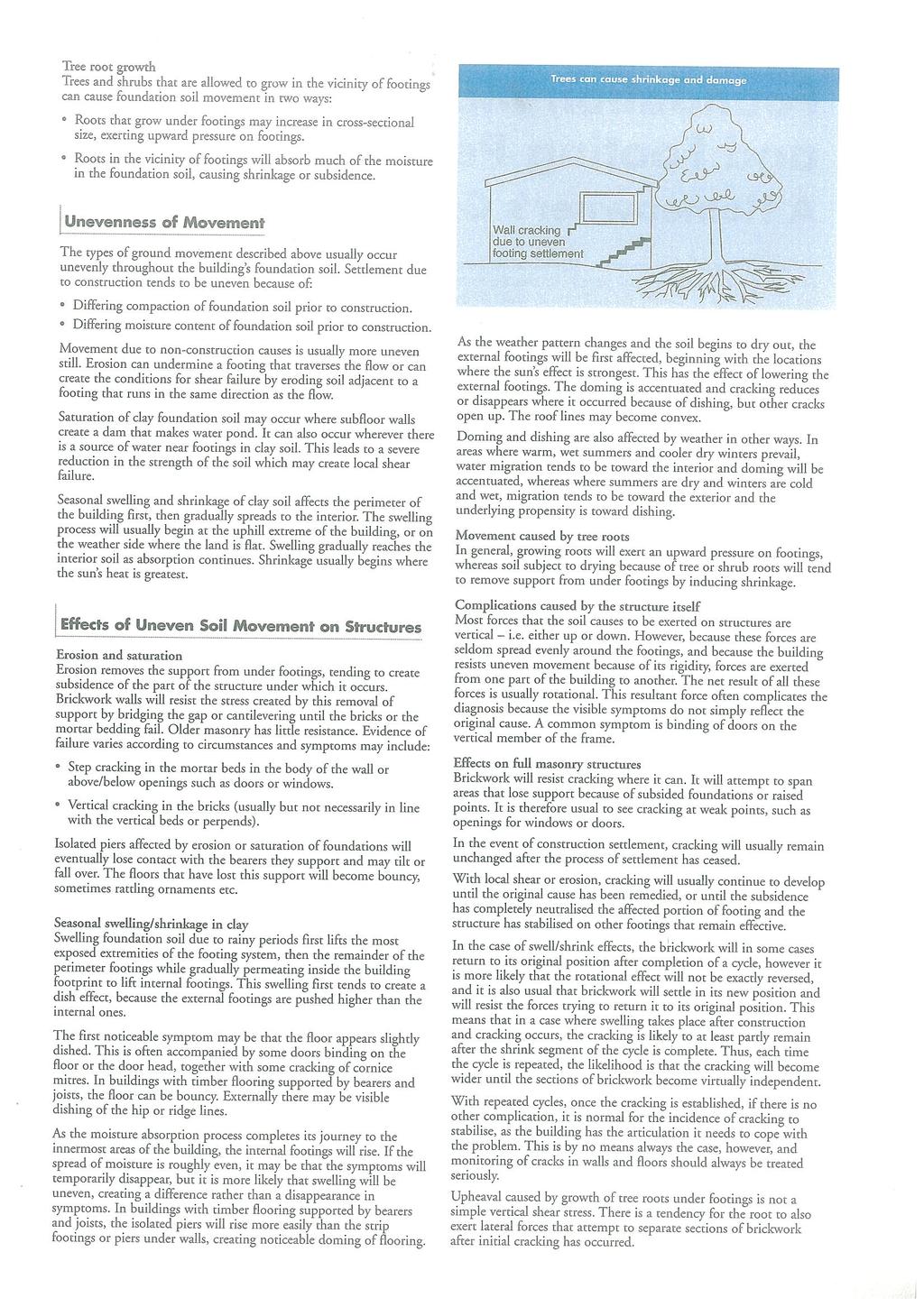
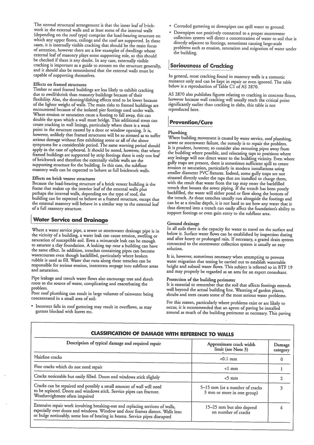
9 Page 6 Reactive sites are sites consisting of clay soils that swell on wetting and shrink on drying resulting in ground movements that can damage lightly loaded structures founded on inappropriately designed footing systems. The amount of ground movement is mainly related to the physical properties of the clay and environmental factors such as climate, vegetation and watering. A higher probability of damage can occur on reactive sites where abnormal moisture conditions occur, due to factors such as: growth of trees too close to a footing or removal of trees prior to construction; lack of maintenance of site drainage, failure to repair plumbing leaks and excessive or irregular watering of gardens adjacent to the house; unusual moisture conditions caused by removal of structures, ground covers (pavements), drains and dams, etc. The growth of trees too close to footings can result in damage to footings and structures on reactive sites due to drying of the clay soils at substantial distances. Appendix B of AS indicates that to reduce but not eliminate the possibility of damage, trees should be restricted to a distance from the building of ¾ the mature height and 1 the mature height for Class M and H sites, respectively. Where rows or groups of trees are present the distance from the building should be increased. Removal of trees from the site prior to or after construction can also cause similar problems. In regard to the performance of footings systems, AS states footing systems complying with this standard are intended to achieve acceptable probabilities of serviceability and safety of the building during its design life. Buildings supported by footing systems designed and constructed in accordance with this Standard on a normal site which is (a) (b) not subject to abnormal moisture conditions; and maintained such that the original site classification remains valid and abnormal moisture conditions do not develop; are expected to experience usually no damage, a low incidence of damage Category 1 and an occasional incidence of damage Category 2. Damage categories are defined in Appendix C of AS , which is reproduced in CSIRO Sheet No BFT 18, A Guide to Home Owners on Foundation Maintenance and Footing Performance, which is attached to this report. North Lakes Pty Ltd Geotechnical Investigation North Lakes Estate Stage 40, Cameron Park RCA ref /0, April 2008
10 Page SITE CLASSIFICATION AND DISCUSSION As previously noted in Section, the results of the laboratory shrink swell tests indicated that the residual clay soils encountered at the site are moderately to extremely reactive. Based on the soil profiles encountered in the test pits excavated at the site together with the laboratory shrink swell test results, and in accordance with AS , Lots 4001 to 4031 within Stage 40 of North Lakes Estate, Cameron Park, in their existing condition and in the absence of abnormal moisture conditions are classified as Class H, Highly reactive, provided that all footings (ie, edge beams, internal beams and load support thickenings) are founded below any topsoil or fill. A characteristic surface movement of up to 50-60mm has been estimated for the site in its existing condition. It is noted that where moderately weathered or fresher rock was present within a depth of about 0.7m, characteristic surface movements that are less than that associated with a Class H site may be calculated. As noted in Section 4.1.2, weathered sandstone and siltstone was encountered in many test pits at depths less than 0.7m. However, given the variability in rock depth we consider that the adoption of a site classification for a lesser characteristic surface movement than for a Class H site would require lot specific assessment (only applicable where rock is likely to be encountered within depths of 0.7m). Reference should also be made to the following paragraphs in regard to the influence of trees when considering the likely applicability of a site classification for a lesser characteristic surface movement than for a Class H site. In the presence of abnormal moisture conditions a significant increase in the free surface movement estimated above may be expected. In consideration of the previous discussion in Section and Clause of AS , abnormal moisture conditions may be expected to occur at the site where trees are removed and insufficient time is allowed for the soil moisture to stabilise prior to construction or where trees are present too close to footings (refer to Section 5.1.1). Consequently, it is suggested that trees be removed well in advance of construction, ie, at least six to 12 months prior to construction. If this was not possible and/or trees were retained in proximity to buildings, the effects of trees and/or removal of trees on the soil moisture conditions would need to be taken into consideration in footing design. The above site classification is for the site conditions present at the time of fieldwork and consequently the site classification may need to be reviewed in consideration of site works that may be undertaken subsequent to this report. Site works may include: North Lakes Pty Ltd Geotechnical Investigation North Lakes Estate Stage 40, Cameron Park RCA ref /0, April 2008
11 Page 8 changes to the existing soil profile by cutting and filling; landscaping, including trees removed from the general building area and those planted; drainage and watering systems. Designs and design methods presented in AS are based on the performance requirement that significant damage can be avoided provided that site conditions are properly maintained. Performance requirements and foundation maintenance are outlined in Appendix B of AS The above site classification assumes that the performance requirements as set out in Appendix B are acceptable and that site foundation maintenance is undertaken to avoid extremes of wetting and drying. Details on appropriate site and foundation maintenance practices are presented in Appendix B of AS and in CSIRO information sheet BTF 18, which is attached in Appendix D. 5.2 GEOTECHNICAL DEVELOPMENT GUIDELINES FOUNDATIONS All footings should be designed and constructed in accordance with AS , Residential Slabs and Footings Construction. All footings should be founded below any topsoil, slopewash, deleterious soils or existing fill. Where possible, all footings for the same structure should be founded on similar materials with articulation provided where appropriate. Where weathered rock is exposed in footing excavations across part of the structure, it is recommended that all footings for the structure should be uniformly founded on weathered rock. This could generally be expected to require the deepening of edge beams and/or the use of piered footings. If it were not practicable to found structures on similar strata, this would need to be considered in structural design and detailing and features such as articulation incorporated. It is suggested that high-level footings founded on the residual clay soils below any existing fill, topsoil, slopewash or deleterious soils, or founded on engineered fill that is placed and compacted in accordance with AS , may be proportioned based on an allowable bearing capacity of 100kPa. It is suggested that high level footings founded on weathered rock may be proportioned based on an allowable bearing capacity of 250kPa. North Lakes Pty Ltd Geotechnical Investigation North Lakes Estate Stage 40, Cameron Park RCA ref /0, April 2008
12 Page 9 Inspection of high-level footing excavations should be undertaken during construction to confirm founding conditions. The base of all footing excavations should be cleaned of fall-in prior to formation of the footing EXCAVATIONS All excavations should be battered at 2H:1V or flatter and protected against erosion or supported by properly designed and constructed retaining walls. Excavations may be battered steeper than 2H:1V in weathered rock materials, subject to specific geotechnical assessment. The soils encountered at the site are judged to be susceptible to erosion and should be protected by vegetation or similar together with adequate drainage where exposed. Appropriate site surface drainage should be installed to intercept up-slope overland surface flows and to restrict overland surface flows from flowing on to areas adjacent to structures FILLING Any filling undertaken as part of residential development on an individual Lot should be placed and compacted in accordance with AS , Guidelines on Earthworks for Commercial and Residential Development. Site preparation for placement of fill should include removal of any existing fill, topsoil, slopewash or deleterious soils from areas where fill is to be placed. Where fill is placed on slopes of surface gradient greater than about 8H:1V (about 7 ) a benched (stepped) foundation should be cut into the slope to provide a level platform for the fill. All fill should be supported by properly designed and constructed retaining walls or else battered at 2H:1V or flatter and protected against erosion by vegetation or similar and the provision of adequate drainage RETAINING WALLS All structural retaining walls should be engineer designed and all garden landscaping walls in excess of 1m in height should be engineer designed. Design of retaining walls should: consider surcharge loading from slopes and structures above the retaining wall; take into account loading from any proposed compaction of fill behind the retaining wall; North Lakes Pty Ltd Geotechnical Investigation North Lakes Estate Stage 40, Cameron Park RCA ref /0, April 2008
13 Page 10 provide adequate surface and subsurface drainage behind all retaining walls, including a free draining granular backfill to prevent the build-up of hydrostatic pressures behind the retaining wall; utilise materials that are not susceptible to deterioration; ensure that retaining walls are founded in materials appropriate for the loading conditions DRAINAGE AND SEPTIC SERVICES All collected storm water should be piped to the street drainage system, an interallotment drainage system or other suitably approved drainage system and discharged in a controlled manner. Appropriate surface drainage should be installed to intercept up-slope overland surface run-off flows. All septic wastes should be connected to the reticulated wastewater system. 6 LIMITATIONS This report has been prepared for North Lakes Pty Ltd in accordance with the agreement with RCA Australia (RCA). The services performed by RCA have been conducted in a manner consistent with that generally exercised by members of its profession and consulting practice. This report has been prepared for the sole use of North Lakes Pty Ltd for the specific purpose and the specific development described in the report. The report may not contain sufficient information for purposes or developments other than that described in the report or for parties other than North Lakes Pty Ltd. This report shall only be presented in full and may not be used to support objectives other than those stated in the report without permission. The information in this report is considered accurate at the date of issue with regard to the current conditions of the site. The conclusions drawn in the report are based on interpolation between boreholes or test pits. Conditions can vary between test locations that cannot be explicitly defined or inferred by investigation. North Lakes Pty Ltd Geotechnical Investigation North Lakes Estate Stage 40, Cameron Park RCA ref /0, April 2008
14
15 Appendix A Drawing

16
17 Appendix B Engineering Logs Symbol Index Sheet General Soil Description Sheets General Rock Description Sheets
18 TEST PIT LOG TP1 SHEET 1 OF 1 PROJECT No: 6749 CLIENT: McCloys Pty Ltd PROJECT: Site Classification LOCATION: Cameron Park Test Pit Information DATE COMMENCED: 03/04/2008 DATE COMPLETED: 03/04/2008 SURFACE LEVEL: COORDS: Field Material Information WATER FIELD TEST SAMPLE RL (m AHD) DEPTH (m) GRAPHIC LOG CLASSIFICATION SYMBOL SM DESCRIPTION (SOIL NAME; plasticity/grain size, colour, particle shape, secondary components, minor constituents) (ROCK NAME; grain size, colour, minor constituents) TOPSOIL, Silty SAND, fine to medium grained, dark brown MOISTURE/ WEATHERING M CONSISTENCY/ RELATIVE DENSITY/ STRENGTH STRUCTURE/AESTHETICS AND ADDITIONAL OBSERVATIONS TOPSOIL 0.10 SC TOPSOIL, Clayey SAND, fine to medium grained, brown 0.20 CH Sitly CLAY, high plasticity, grey VSt RESIDUAL SOIL Not Encountered PP=325kPa 0.35m U m 0.60 SANDSTONE, fine to medium grained, grey/brown mottled orange MW L - M BEDROCK 0.70 TEST PIT TP1 TERMINATED AT 0.70 m at excavator refusal on sandstone RCA_LIB_01.GLB Log RCA NON CORED LOG 6749 BORES.GPJ <<DrawingFile>> 16/04/ :56 Produced by gint Professional, Developed by Datgel LOGGED: CS CHECKED: MA DATE: 11/04/2008
19 TEST PIT LOG TP2 SHEET 1 OF 1 PROJECT No: 6749 CLIENT: McCloys Pty Ltd PROJECT: Site Classification LOCATION: Cameron Park Test Pit Information DATE COMMENCED: 03/04/2008 DATE COMPLETED: 03/04/2008 SURFACE LEVEL: COORDS: Field Material Information WATER FIELD TEST SAMPLE RL (m AHD) DEPTH (m) GRAPHIC LOG CLASSIFICATION SYMBOL SM DESCRIPTION (SOIL NAME; plasticity/grain size, colour, particle shape, secondary components, minor constituents) (ROCK NAME; grain size, colour, minor constituents) TOPSOIL, Silty SAND, fine grained, dark grey MOISTURE/ WEATHERING M CONSISTENCY/ RELATIVE DENSITY/ STRENGTH STRUCTURE/AESTHETICS AND ADDITIONAL OBSERVATIONS TOPSOIL 0.10 SC Clayey SAND, fine to medium grained, brown/grey mottled orange RESIDUAL SOIL Not Encountered PP=245kPa SC Clayey SAND fine to medium grained, grey mottled brown/orange, sandstone cobbles present RCA_LIB_01.GLB Log RCA NON CORED LOG 6749 BORES.GPJ <<DrawingFile>> 16/04/ :58 Produced by gint Professional, Developed by Datgel LOGGED: CS SANDSTONE, fine to medium grained, grey mottled brown TEST PIT TP2 TERMINATED AT 1.15 m at excavator refusal on sandstone CHECKED: MA MW L - M BEDROCK DATE: 11/04/2008
20 TEST PIT LOG TP3 SHEET 1 OF 1 PROJECT No: 6749 CLIENT: McCloys Pty Ltd PROJECT: Site Classification LOCATION: Cameron Park Test Pit Information DATE COMMENCED: 03/04/2008 DATE COMPLETED: 03/04/2008 SURFACE LEVEL: COORDS: Field Material Information WATER FIELD TEST SAMPLE RL (m AHD) DEPTH (m) GRAPHIC LOG CLASSIFICATION SYMBOL SM DESCRIPTION (SOIL NAME; plasticity/grain size, colour, particle shape, secondary components, minor constituents) (ROCK NAME; grain size, colour, minor constituents) TOPSOIL, Silty SAND, fine to medium grained, grey MOISTURE/ WEATHERING D CONSISTENCY/ RELATIVE DENSITY/ STRENGTH STRUCTURE/AESTHETICS AND ADDITIONAL OBSERVATIONS TOPSOIL 0.10 SM Sandy SILT, fine grained, grey RESIDUAL SOIL Not Encountered 0.20 SANDSTONE, fine to medium grained, brown (orange tinge) MW L - M BEDROCK 0.50 TEST PIT TP3 TERMINATED AT 0.50 m at excavator refusal on sandstone RCA_LIB_01.GLB Log RCA NON CORED LOG 6749 BORES.GPJ <<DrawingFile>> 16/04/ :58 Produced by gint Professional, Developed by Datgel LOGGED: CS CHECKED: MA DATE: 11/04/2008
21 TEST PIT LOG TP4 SHEET 1 OF 1 PROJECT No: 6749 CLIENT: McCloys Pty Ltd PROJECT: Site Classification LOCATION: Cameron Park Test Pit Information DATE COMMENCED: 03/04/2008 DATE COMPLETED: 03/04/2008 SURFACE LEVEL: COORDS: Field Material Information WATER FIELD TEST SAMPLE RL (m AHD) DEPTH (m) GRAPHIC LOG CLASSIFICATION SYMBOL DESCRIPTION (SOIL NAME; plasticity/grain size, colour, particle shape, secondary components, minor constituents) (ROCK NAME; grain size, colour, minor constituents) MOISTURE/ WEATHERING CONSISTENCY/ RELATIVE DENSITY/ STRENGTH STRUCTURE/AESTHETICS AND ADDITIONAL OBSERVATIONS SM TOPSOIL, Sandy SILT, fine grained, grey D TOPSOIL 0.20 SM Silty SAND, fine to medium grained, grey M SLOPE WASH Not Encountered SANDSTONE, fine grained, grey/brown (orange tringe) MW M BEDROCK 0.70 TEST PIT TP4 TERMINATED AT 0.70 m at excavator refusal on sandstone RCA_LIB_01.GLB Log RCA NON CORED LOG 6749 BORES.GPJ <<DrawingFile>> 16/04/ :58 Produced by gint Professional, Developed by Datgel LOGGED: CS CHECKED: MA DATE: 11/04/2008
22 TEST PIT LOG TP5 SHEET 1 OF 1 PROJECT No: 6749 CLIENT: McCloys Pty Ltd PROJECT: Site Classification LOCATION: Cameron Park Test Pit Information DATE COMMENCED: 03/04/2008 DATE COMPLETED: 03/04/2008 SURFACE LEVEL: COORDS: Field Material Information WATER FIELD TEST SAMPLE RL (m AHD) DEPTH (m) GRAPHIC LOG CLASSIFICATION SYMBOL SM DESCRIPTION (SOIL NAME; plasticity/grain size, colour, particle shape, secondary components, minor constituents) (ROCK NAME; grain size, colour, minor constituents) TOPSOIL, Sandy SILT, fine grained, grey MOISTURE/ WEATHERING M CONSISTENCY/ RELATIVE DENSITY/ STRENGTH L STRUCTURE/AESTHETICS AND ADDITIONAL OBSERVATIONS TOPSOIL 0.10 CH Silty CLAY, high plasticity, grey St RESIDUAL SOIL Not Encountered PP=165kPa 0.40m U m 0.80 SANDSTONE, brown orange tinged, some grey mottling MW L - M BEDROCK RCA_LIB_01.GLB Log RCA NON CORED LOG 6749 BORES.GPJ <<DrawingFile>> 16/04/ :58 Produced by gint Professional, Developed by Datgel LOGGED: CS TEST PIT TP5 TERMINATED AT 0.90 m at excavator refusal on sandstone CHECKED: MA DATE: 11/04/2008
23 TEST PIT LOG TP6 SHEET 1 OF 1 PROJECT No: 6749 CLIENT: McCloys Pty Ltd PROJECT: Site Classification LOCATION: Cameron Park Test Pit Information DATE COMMENCED: 03/04/2008 DATE COMPLETED: 03/04/2008 SURFACE LEVEL: COORDS: Field Material Information WATER FIELD TEST SAMPLE RL (m AHD) DEPTH (m) GRAPHIC LOG CLASSIFICATION SYMBOL SM DESCRIPTION (SOIL NAME; plasticity/grain size, colour, particle shape, secondary components, minor constituents) (ROCK NAME; grain size, colour, minor constituents) TOPSOIL, Silty SAND, fine to medium grained, brown MOISTURE/ WEATHERING D CONSISTENCY/ RELATIVE DENSITY/ STRENGTH STRUCTURE/AESTHETICS AND ADDITIONAL OBSERVATIONS TOPSOIL 0.10m U CI Silty CLAY, medium plasticity, brown, orange mottled M VSt RESIDUAL SOIL Not Encountered PP=225kPa 0.55m SILTSTONE (TUFF), very fine grained, grey, some iron oxide staining MW H 0.65 TEST PIT TP6 TERMINATED AT 0.65 m at excavator refusal on sandstone RCA_LIB_01.GLB Log RCA NON CORED LOG 6749 BORES.GPJ <<DrawingFile>> 16/04/ :58 Produced by gint Professional, Developed by Datgel LOGGED: CS CHECKED: MA DATE: 11/04/2008
24 TEST PIT LOG TP7 SHEET 1 OF 1 PROJECT No: 6749 CLIENT: McCloys Pty Ltd PROJECT: Site Classification LOCATION: Cameron Park Test Pit Information DATE COMMENCED: 03/04/2008 DATE COMPLETED: 03/04/2008 SURFACE LEVEL: COORDS: Field Material Information WATER FIELD TEST SAMPLE RL (m AHD) DEPTH (m) GRAPHIC LOG CLASSIFICATION SYMBOL SM DESCRIPTION (SOIL NAME; plasticity/grain size, colour, particle shape, secondary components, minor constituents) (ROCK NAME; grain size, colour, minor constituents) TOPSOIL, Silty SAND, fine to meidum grained, dark brown MOISTURE/ WEATHERING D CONSISTENCY/ RELATIVE DENSITY/ STRENGTH STRUCTURE/AESTHETICS AND ADDITIONAL OBSERVATIONS TOPSOIL 0.35m U CI Silty CLAY, medium plasticity, grey M VSt RESIDUAL SOIL Not Encountered PP=360kPa m RCA_LIB_01.GLB Log RCA NON CORED LOG 6749 BORES.GPJ <<DrawingFile>> 16/04/ :58 Produced by gint Professional, Developed by Datgel PP=300kPa LOGGED: CS SILTSTONE, slatey brown TEST PIT TP7 TERMINATED AT 1.10 m at excavator refusal on siltstone CHECKED: MA HW L BEDROCK DATE: 11/04/2008
25 TEST PIT LOG TP8 SHEET 1 OF 1 PROJECT No: 6749 CLIENT: McCloys Pty Ltd PROJECT: Site Classification LOCATION: Cameron Park Test Pit Information DATE COMMENCED: 03/04/2008 DATE COMPLETED: 03/04/2008 SURFACE LEVEL: COORDS: Field Material Information WATER FIELD TEST SAMPLE RL (m AHD) DEPTH (m) GRAPHIC LOG CLASSIFICATION SYMBOL DESCRIPTION (SOIL NAME; plasticity/grain size, colour, particle shape, secondary components, minor constituents) (ROCK NAME; grain size, colour, minor constituents) MOISTURE/ WEATHERING CONSISTENCY/ RELATIVE DENSITY/ STRENGTH STRUCTURE/AESTHETICS AND ADDITIONAL OBSERVATIONS SM TOPSOIL, Silty SAND, fine grained, grey D / M L TOPSOIL 0.35 CI Silty CLAY, medium plasticity M VSt RESIDUAL SOIL Not Encountered PP=285kPa 0.5 RCA_LIB_01.GLB Log RCA NON CORED LOG 6749 BORES.GPJ <<DrawingFile>> 16/04/ :58 Produced by gint Professional, Developed by Datgel PP=370kPa LOGGED: CS SILTSTONE (shale), fine grained, brown TEST PIT TP8 TERMINATED AT 1.20 m at excavator refusal on siltstone CHECKED: MA EW L BEDROCK DATE: 11/04/2008
26 TEST PIT LOG TP9 SHEET 1 OF 1 PROJECT No: 6749 CLIENT: McCloys Pty Ltd PROJECT: Site Classification LOCATION: Cameron Park Test Pit Information DATE COMMENCED: 03/04/2008 DATE COMPLETED: 03/04/2008 SURFACE LEVEL: COORDS: Field Material Information WATER FIELD TEST SAMPLE RL (m AHD) DEPTH (m) GRAPHIC LOG CLASSIFICATION SYMBOL CI DESCRIPTION (SOIL NAME; plasticity/grain size, colour, particle shape, secondary components, minor constituents) (ROCK NAME; grain size, colour, minor constituents) Silty SAND/Sandy CLAY, medium plasticity, grey MOISTURE/ WEATHERING D CONSISTENCY/ RELATIVE DENSITY/ STRENGTH STRUCTURE/AESTHETICS AND ADDITIONAL OBSERVATIONS RESIDUAL SOIL 0.25 CI Silty CLAY, medium plasticity, grey M VSt PP=190kPa Not Encountered 0.5 RCA_LIB_01.GLB Log RCA NON CORED LOG 6749 BORES.GPJ <<DrawingFile>> 16/04/ :58 Produced by gint Professional, Developed by Datgel PP=470kPa LOGGED: CS SILTSTONE (shale), fine grained, brown, extremely weathered TEST PIT TP9 TERMINATED AT 1.15 m at excavator refusal on siltstone CHECKED: MA EW VL BEDROCK DATE: 11/04/2008
27 TEST PIT LOG TP10 SHEET 1 OF 1 PROJECT No: 6749 CLIENT: McCloys Pty Ltd PROJECT: Site Classification LOCATION: Cameron Park Test Pit Information DATE COMMENCED: 03/04/2008 DATE COMPLETED: 03/04/2008 SURFACE LEVEL: COORDS: Field Material Information WATER FIELD TEST SAMPLE RL (m AHD) DEPTH (m) GRAPHIC LOG CLASSIFICATION SYMBOL SM DESCRIPTION (SOIL NAME; plasticity/grain size, colour, particle shape, secondary components, minor constituents) (ROCK NAME; grain size, colour, minor constituents) TOPSOIL, Silty SAND, fine grained, grey MOISTURE/ WEATHERING D L TOPSOIL 0.15 CI Silty CLAY, medium plasticity, grey M VSt RESIDUAL SOIL PP=320kPa Not Encountered CONSISTENCY/ RELATIVE DENSITY/ STRENGTH STRUCTURE/AESTHETICS AND ADDITIONAL OBSERVATIONS 0.5 PP=200kPa 0.80 CL Silty CLAY, low plasticity, light brown to cream St RCA_LIB_01.GLB Log RCA NON CORED LOG 6749 BORES.GPJ <<DrawingFile>> 16/04/ :57 Produced by gint Professional, Developed by Datgel LOGGED: CS SILTSTONE (shale), fine grained, brown TEST PIT TP10 TERMINATED AT 1.40 m at excavator refusal on siltstone CHECKED: MA EW VL BEDROCK DATE: 11/04/2008
28 TEST PIT LOG TP11 SHEET 1 OF 1 PROJECT No: 6749 CLIENT: McCloys Pty Ltd PROJECT: Site Classification LOCATION: Cameron Park Test Pit Information DATE COMMENCED: 03/04/2008 DATE COMPLETED: 03/04/2008 SURFACE LEVEL: COORDS: Field Material Information WATER FIELD TEST SAMPLE RL (m AHD) DEPTH (m) GRAPHIC LOG CLASSIFICATION SYMBOL SM DESCRIPTION (SOIL NAME; plasticity/grain size, colour, particle shape, secondary components, minor constituents) (ROCK NAME; grain size, colour, minor constituents) TOPSOIL, Silty SAND, fine grained, grey MOISTURE/ WEATHERING M CONSISTENCY/ RELATIVE DENSITY/ STRENGTH L STRUCTURE/AESTHETICS AND ADDITIONAL OBSERVATIONS TOPSOIL Not Encountered PP=365kPa 0.25m U CI Silty CLAY, medium plasticity, brown mottled orange VSt RESIDUAL SOIL 0.40m 0.40 TEST PIT TP11 TERMINATED AT 0.40 m at excavator refusal on sandstone 0.5 RCA_LIB_01.GLB Log RCA NON CORED LOG 6749 BORES.GPJ <<DrawingFile>> 16/04/ :57 Produced by gint Professional, Developed by Datgel LOGGED: CS CHECKED: MA DATE: 11/04/2008
29 TEST PIT LOG TP12 SHEET 1 OF 1 PROJECT No: 6749 CLIENT: McCloys Pty Ltd PROJECT: Site Classification LOCATION: Cameron Park Test Pit Information DATE COMMENCED: 03/04/2008 DATE COMPLETED: 03/04/2008 SURFACE LEVEL: COORDS: Field Material Information WATER FIELD TEST SAMPLE RL (m AHD) DEPTH (m) GRAPHIC LOG CLASSIFICATION SYMBOL DESCRIPTION (SOIL NAME; plasticity/grain size, colour, particle shape, secondary components, minor constituents) (ROCK NAME; grain size, colour, minor constituents) MOISTURE/ WEATHERING CONSISTENCY/ RELATIVE DENSITY/ STRENGTH STRUCTURE/AESTHETICS AND ADDITIONAL OBSERVATIONS SM TOPSOIL, Silty SAND, fine to medium grained, brown M L TOPSOIL Not Encountered 0.30 CI Sandy Silty CLAY, medium plasticity, brown mottled grey VSt RESIDUAL SOIL PP=265kPa SANDSTONE, fine to medium grained, brown MW L - MD BEDROCK 0.70 TEST PIT TP12 TERMINATED AT 0.70 m at excavator refusal on sandstone RCA_LIB_01.GLB Log RCA NON CORED LOG 6749 BORES.GPJ <<DrawingFile>> 16/04/ :57 Produced by gint Professional, Developed by Datgel LOGGED: CS CHECKED: MA DATE: 11/04/2008
30 TEST PIT LOG TP13 SHEET 1 OF 1 PROJECT No: 6749 CLIENT: McCloys Pty Ltd PROJECT: Site Classification LOCATION: Cameron Park Test Pit Information DATE COMMENCED: 03/04/2008 DATE COMPLETED: 03/04/2008 SURFACE LEVEL: COORDS: Field Material Information WATER FIELD TEST SAMPLE RL (m AHD) DEPTH (m) GRAPHIC LOG CLASSIFICATION SYMBOL SM DESCRIPTION (SOIL NAME; plasticity/grain size, colour, particle shape, secondary components, minor constituents) (ROCK NAME; grain size, colour, minor constituents) TOPSOIL, Silty SAND/Sandy SILT, fine grained, grey MOISTURE/ WEATHERING D CONSISTENCY/ RELATIVE DENSITY/ STRENGTH L STRUCTURE/AESTHETICS AND ADDITIONAL OBSERVATIONS TOPSOIL Not Encountered 0.20 CL Sandy Silty CLAY, low plasticity, fine grained, H RESIDUAL SOIL PP>600kPa 0.40 SANDSTONE, fine to medium grained, brown orange tinge MW L - MD BEDROCK 0.50 TEST PIT TP13 TERMINATED AT 0.50 m at excavator refusal on sandstone RCA_LIB_01.GLB Log RCA NON CORED LOG 6749 BORES.GPJ <<DrawingFile>> 16/04/ :58 Produced by gint Professional, Developed by Datgel LOGGED: CS CHECKED: MA DATE: 11/04/2008
31 TEST PIT LOG TP14 SHEET 1 OF 1 PROJECT No: 6749 CLIENT: McCloys Pty Ltd PROJECT: Site Classification LOCATION: Cameron Park Test Pit Information DATE COMMENCED: 03/04/2008 DATE COMPLETED: 03/04/2008 SURFACE LEVEL: COORDS: Field Material Information WATER FIELD TEST SAMPLE RL (m AHD) DEPTH (m) GRAPHIC LOG CLASSIFICATION SYMBOL SM DESCRIPTION (SOIL NAME; plasticity/grain size, colour, particle shape, secondary components, minor constituents) (ROCK NAME; grain size, colour, minor constituents) TOPSOIL, Silty SAND, fine grained, grey MOISTURE/ WEATHERING D CONSISTENCY/ RELATIVE DENSITY/ STRENGTH L STRUCTURE/AESTHETICS AND ADDITIONAL OBSERVATIONS Not Encountered TOPSOIL 0.35 CI Silty CLAY, medium plasticity M VSt RESIDUAL SOIL PP=390kPa TEST PIT TP14 TERMINATED AT 0.60 m at excavator refusal on sandstone RCA_LIB_01.GLB Log RCA NON CORED LOG 6749 BORES.GPJ <<DrawingFile>> 16/04/ :58 Produced by gint Professional, Developed by Datgel LOGGED: CS CHECKED: MA DATE: 11/04/2008
32 TEST PIT LOG TP15 SHEET 1 OF 1 PROJECT No: 6749 CLIENT: McCloys Pty Ltd PROJECT: Site Classification LOCATION: Cameron Park Test Pit Information DATE COMMENCED: 03/04/2008 DATE COMPLETED: 03/04/2008 SURFACE LEVEL: COORDS: Field Material Information WATER FIELD TEST SAMPLE RL (m AHD) DEPTH (m) GRAPHIC LOG CLASSIFICATION SYMBOL SM DESCRIPTION (SOIL NAME; plasticity/grain size, colour, particle shape, secondary components, minor constituents) (ROCK NAME; grain size, colour, minor constituents) TOPSOIL, Silty SAND, fine grained, grey MOISTURE/ WEATHERING M CONSISTENCY/ RELATIVE DENSITY/ STRENGTH L STRUCTURE/AESTHETICS AND ADDITIONAL OBSERVATIONS TOPSOIL Not Encountered PP=190kPa 0.25 CL Silty CLAY, low plasticity, grey, brown mottled grey/orange St RESIDUAL SOIL 0.50 TEST PIT TP15 TERMINATED AT 0.50 m at excavator refusal on sandstone RCA_LIB_01.GLB Log RCA NON CORED LOG 6749 BORES.GPJ <<DrawingFile>> 16/04/ :58 Produced by gint Professional, Developed by Datgel LOGGED: CS CHECKED: MA DATE: 11/04/2008
33 TEST PIT LOG TP16 SHEET 1 OF 1 PROJECT No: 6749 CLIENT: McCloys Pty Ltd PROJECT: Site Classification LOCATION: Cameron Park Test Pit Information DATE COMMENCED: 03/04/2008 DATE COMPLETED: 03/04/2008 SURFACE LEVEL: COORDS: Field Material Information WATER FIELD TEST SAMPLE RL (m AHD) DEPTH (m) GRAPHIC LOG CLASSIFICATION SYMBOL SM DESCRIPTION (SOIL NAME; plasticity/grain size, colour, particle shape, secondary components, minor constituents) (ROCK NAME; grain size, colour, minor constituents) TOPSOIL, Silty SAND, fine grained, grey MOISTURE/ WEATHERING D CONSISTENCY/ RELATIVE DENSITY/ STRENGTH STRUCTURE/AESTHETICS AND ADDITIONAL OBSERVATIONS TOPSOIL 0.20 CI Silty CLAY, medium plasticity, grey mottled brown M VSt RESIDUAL SOIL Not Encountered PP=320kPa SILTSTONE, fine grained, grey/brown mottled EW M BEDROCK RCA_LIB_01.GLB Log RCA NON CORED LOG 6749 BORES.GPJ <<DrawingFile>> 16/04/ :58 Produced by gint Professional, Developed by Datgel LOGGED: CS TEST PIT TP16 TERMINATED AT 0.80 m at excavator refusal on siltstone CHECKED: MA DATE: 11/04/2008
34 TEST PIT LOG TP17 SHEET 1 OF 1 PROJECT No: 6749 CLIENT: McCloys Pty Ltd PROJECT: Site Classification LOCATION: Cameron Park Test Pit Information DATE COMMENCED: 03/04/2008 DATE COMPLETED: 03/04/2008 SURFACE LEVEL: COORDS: Field Material Information WATER FIELD TEST SAMPLE RL (m AHD) DEPTH (m) GRAPHIC LOG CLASSIFICATION SYMBOL SM DESCRIPTION (SOIL NAME; plasticity/grain size, colour, particle shape, secondary components, minor constituents) (ROCK NAME; grain size, colour, minor constituents) TOPSOIL, Silty SAND, fine grained, grey MOISTURE/ WEATHERING D CONSISTENCY/ RELATIVE DENSITY/ STRENGTH STRUCTURE/AESTHETICS AND ADDITIONAL OBSERVATIONS TOPSOIL / SLOPE WASH Not Encountered Becoming Silty CLAY PP>600kPa SANDSTONE, fine to medium grained TEST PIT TP17 TERMINATED AT 0.50 m at excavator refusal on sandstone EW L BEDROCK RCA_LIB_01.GLB Log RCA NON CORED LOG 6749 BORES.GPJ <<DrawingFile>> 16/04/ :58 Produced by gint Professional, Developed by Datgel LOGGED: CS CHECKED: MA DATE: 11/04/2008
35 Explanatory Notes Soil Description In engineering terms soil includes every type of uncemented or partially cemented inorganic material found in the ground. In practice, if the material can be remoulded by hand in its field condition or in water it is described as a soil. The dominant soil constituent is given in capital letters, with secondary textures in lower case. The dominant feature is assessed from the Unified Soil Classification system and a soil symbol is used to define a soil layer. METHOD Method AS AD/V AD/T BH CT N X E EH HA HQ NMLC NQ PT RR DB WS AT DT Description Auger Screwing Auger Drilling with V Bit Auger Drilling with TC bit Backhoe Cable Tool Rig Natural Exposure Existing Excavation Excavator Excavator with Hammer Hand Auger Diamond Core-63mm Diamond Core-52mm Diamond Core-47mm Push Tube Rock Roller Washbore Drag Bit Washbone Air Track Diatube MOISTURE CONDITION Dry Cohesive soils are friable or powdery Cohesionless soil grains are free-running. Moist Soil feels cool, darkened in colour Cohesive soils can be moulded Cohesionless soil grains tend to adhere. Wet Cohesive soils usually weakened Free water forms on hands when handling. For cohesive soils the following codes may also be used: MC>PL Moisture Content greater than the Plastic Limit. MC-PL Moisture Content near the Plastic Limit. MC<PL Moisture Content less than the Plastic Limit. PLASTICITY The potential for soil to undergo change in volume with moisture change is assessed from its degree of plasticity. The classification of the degree of plasticity in terms of the Liquid Limit (LL) is as follows. Description of Plasticity LL(%) Water Water level at date shown Seepage NOT ENCOUNTERED: The borehole/test pit was dry soon after excavation. Inflow may have been observed had the borehole/test pit been left open for a longer period. NOT OBSERVED: The observation of groundwater, whether present or not, was not possible due to drilling water, surface seepage or cave in of the borehole/test pit. SAMPLING Sample B D SPT U50 ES EW G Description Bulk Disturbed Sample Disturbed Sample Standard Penetration Test Undisturbed Sample-50mm Soil Sample, Environmental Water Sample, Environmental Gas Sample UNIFIED SOIL CLASSIFICATION The appropriate symbols are selected on the result of visual examination, field tests and available laboratory tests, such as sieve analysis, liquid limit and plasticity index. USC Symbol Description GW Well graded gravel GP Poorly graded gravel GM Silty gravel GC Clayey gravel SW Well graded sand SP Poorly graded sand SM Silty sand SC Clayey sand ML Silt of low plasticity CL Clay of low plasticity OL Organic soil of low plasticity CI Clay of medium plasticity MH Silt of high plasticity CH Clay of high plasticity OH Organic soil of high plasticity Pt Peaty soil AWS-EN-001/0 Low <35 Medium 35 to 50 High >50 COHESIVE SOILS CONSISTENCY The consistency of a cohesive soil is defined by descriptive terminology such as very soft, soft, firm, stiff, very stiff and hard. These terms are assessed by the shear strength of the soil as observed visually, by hand penetrometer values and by resistance to deformation to hand moulding. A Hand Penetrometer may be used in the field or the laboratory to provide an approximate assessment of the unconfined compressive strength (UCS) of cohesive soils. Undrained shear strength Cu = 0.5 UCS. The UCS values are recorded in kpa as follows: Strength Symbol Unconfined Compressive Strength, q u (kpa) Very Soft Soft Firm Stiff Very Stiff Hard VS S F St VSt H < to to to to 400 > 400 COHESIONLESS SOILS RELATIVE DENSITY Relative density terms such as very loose, loose, medium, dense and very dense are used to describe silty and sandy material, and these are usually based on resistance to drilling penetration or the Standard Penetration Test (SPT) N values. Other condition terms, such as friable, powdery or crumbly may also be used. Term Symbol Density Index Very Loose VL 0 to 15 Loose L 15 to 35 Medium Dense MD 35 to 65 Dense D 65 to 85 Very Dense VD >85 N Value (blows/0.3m) 0 to 4 4 to to to 50 >50 COHESIONLESS SOILS PARTICLE SIZE DESCRIPTIVE TERMS Name Subdivision Size Boulders Cobbles >200 mm 63 mm to 200 mm Gravel Coarse medium Fine 20 mm to 63 mm 6 mm to 20 mm 2.36 mm to 6 mm Sand Coarse medium fine 0.6 mm to 2.36 mm 0.2 mm to 0.6 mm mm to 0.2 mm
36 Explanatory Notes - Rock Description METHOD Refer soil description sheet. WATER Refer soil description sheet. ROCK QUALITY The fracture spacing is shown where applicable and the Rock Quality Designation (RQD) or Total Core Recovery (TCR) is given where: TCR (%) = length of core recovered length of core run RQD (%) = sum of axial lengths of core > 100mm long length of core run. ROCK MATERIAL WEATHERING Rock weathering is described using the abbreviations and definitions used in AS1726. Symbol Term Definition EW HW MW SW F Extremely Weathered Highly Weathered Moderately Weathered Slightly weathered Fresh Rock is weathered to such an extent that it has soil properties, ie, it either disintegrates or can be remoulded in water. The rock substance is affected by weathering to the extent that limonite staining or bleaching affects the whole rock substance and other signs of chemical or physical decomposition are evident. Porosity and strength is usually decreased compared to the fresh rock. The colour and strength of the fresh rock is no longer recognisable. The whole of the rock substance is discoloured. Usually by iron staining or bleaching, to the extent that the colour of the fresh rock is no longer recognisable. Rock is slightly discoloured but shows little or no change of strength from fresh rock. Rock shows no sign of decomposition or staining. ROCK STRENGTH Rock strength is described using AS1726 and ISRM Commission on Standardisation of Laboratory and Field Tests, Suggested method of determining the Uniaxial Compressive Strength of Rock materials and the Point Load Index as follows: Term Symbol Point Load Index Is 50 (MPa) Extremely Low Very Low Low Medium High Very High Extremely High EL VL L M H VH EH < to to to 1 1 to 3 3 to 10 >10 Diametral Point Load Index test. Axial Point Load Index test. DEFECT SPACING/BEDDING THICKNESS Measured at right angles to defects of same set or bedding. Term Defect Spacing Bedding Extremely closely spaced Very closely spaced Closely spaced Moderately widely spaced Widely spaced Very widely spaced <6 mm 6 to 20 mm 20 to 60 mm 0.06 to 0.2 m 0.2 to 0.6 m 0.6 to 0.2 m >2 m Thinly laminated Laminated Very thin Thin Medium Thick Very thick DEFECT DESCRIPTION Type JT BP CO CS DK DZ FC FZ FL VN SM IS SZ Planarity PR Planar IR Irregular ST stepped U Undulating CU - Curved Definition Joint Bed Parting Contact Crushed Seam Dyke Decomposed Zone Fracture Fracture Zone Foliation Vein Seam Infilled Seam Shear zone Roughness RF Rough VR Very Rough S Smooth SL Slickensides POL Polished Coating or infill Description Clean No visible coating or infilling. Stain No visible coating or infilling but surfaces are discoloured by mineral staining. Veneer A visible coating or infilling of soil or mineral substance but usually unable to be measured (<1mm). If discontinuous over the plane, patchy veneer. Coating A visible coating or infilling of soil or mineral substance >1mm thick. Describe composition and thickness. The inclinations of defects are measured from perpendicular to the core axis. AWS-EN-001/0
37 Appendix C Laboratory Results
38 Appendix C CSIRO Information Sheet BTF 18
39
40
41
42
Report on Site Classification & Construction Testing
 Report on Site Classification & Construction Testing Northlakes Estate Stage 29, Cameron Park CGS1871 CGS1871 Prepared for Northlakes Pty Ltd C/- McCloy Group Pty Ltd December 2013 Report on Site Classification
 Project: ITHACA-TOMPKINS REGIONAL AIRPORT EXPANSION Project Location: ITHACA, NY Project Number: 218-34 Key to Soil Symbols and Terms TERMS DESCRIBING CONSISTENCY OR CONDITION COARSE-GRAINED SOILS (major
Geotechnical Investigation and Site Classification, Northlakes Estate Stage 21
 Geotechnical Investigation and Site Classification, Northlakes Estate Stage 21 October 2009 North Lakes Pty Ltd Parsons Brinckerhoff Australia Pty Limited ABN 80 078 004 798 2103382A-PR_9366 Level 3 51
APPENDIX A. Borehole Logs Explanation of Terms and Symbols
 APPENDIX A Borehole Logs Explanation of Terms and Symbols Page 153 of 168 EXPLANATION OF TERMS AND SYMBOLS The terms and symbols used on the borehole logs to summarize the results of field investigation
NORTH LAKES ESTATE - STAGE 20 SITE CLASSIFICATION
 NORTH LAKES ESTATE - STAGE 20 SITE CLASSIFICATION North Lakes Pty Ltd GEOTWARA20569AA-AB 28 November 2007 Coffey Geotechnics Pty Ltd ABN 93 056 929 483 19 Warabrook Boulevard Warabrook NSW 2304 Australia
Appendix A. Producer Statement Advisory Note
 Appendix A Producer Statement Advisory Note Ref. No. 17095 26 May 2017 PRODUCER STATEMENT CONSTRUCTION REVIEW (PS4) IMPORTANT ADVISORY NOTE The Building Consent Authority (BCA) frequently requires Producer
 SOIL CLASSIFICATION CHART COARSE-GRAINED SOILS MORE THAN 50% RETAINED ON NO.200 SIEVE FINE-GRAINED SOILS 50% OR MORE PASSES THE NO.200 SIEVE PRIMARY DIVISIONS GRAVELS MORE THAN 50% OF COARSE FRACTION RETAINED
 Photo 1 - Southerly view across 2700 parking lot toward existing building. Multi-residential building borders western side of property in upper right of view. Photo 2 - Southerly view across 2750 parking
Geotechnical Investigation and Site Classification, Northlakes Estate Stages 22, 22A and 51A
 Geotechnical Investigation and Site Classification, Northlakes Estate Stages, A and 5A November 009 North Lakes Pty Ltd Parsons Brinckerhoff Australia Pty Limited ABN 80 078 004 798 03369A-PR_930RevC Level
B-1 BORE LOCATION PLAN. EXHIBIT Drawn By: 115G BROOKS VETERINARY CLINIC CITY BASE LANDING AND GOLIAD ROAD SAN ANTONIO, TEXAS.
 N B-1 SYMBOLS: Exploratory Boring Location Project Mngr: BORE LOCATION PLAN Project No. GK EXHIBIT Drawn By: 115G1063.02 GK Scale: Checked By: 1045 Central Parkway North, Suite 103 San Antonio, Texas 78232
Depth (ft) USCS Soil Description TOPSOIL & FOREST DUFF
 USCS Soil Description TOPSOIL & FOREST DUFF") Test Pit No. TP-6 Location: Latitude 47.543003, Longitude -121.980441 Approximate Ground Surface Elevation: 1,132 feet Depth (ft) USCS Soil Description 0 1.5 1.5 5.0 SM 5.0 8.0 SM Loose to medium dense,
Test Pit No. TP-6 Location: Latitude 47.543003, Longitude -121.980441 Approximate Ground Surface Elevation: 1,132 feet Depth (ft) USCS Soil Description 0 1.5 1.5 5.0 SM 5.0 8.0 SM Loose to medium dense,
Field Exploration. March 31, J-U-B ENGINEERS, Inc. 115 Northstar Avenue Twin Falls, Idaho Attn: Mr. Tracy Ahrens, P. E. E:
 March 31, 201 11 Northstar Avenue 83301 Attn: Mr. Tracy Ahrens, P. E. E: taa@jub.com Re: Geotechnical Data Report Preliminary Phase 1 Field Exploration Revision No. 1 Proposed Rapid Infiltration Basin
Clay Robinson, PhD, CPSS, PG copyright 2009
 Engineering: What's soil got to do with it? Clay Robinson, PhD, CPSS, PG crobinson@wtamu.edu, http://www.wtamu.edu/~crobinson, copyright 2009 Merriam-Webster Online Dictionary soil, noun 1 : firm land
GEOTECHNICAL INVESTIGATION REPORT
 GEOTECHNICAL INVESTIGATION REPORT SOIL INVESTIGATION REPORT FOR STATIC TEST FACILITY FOR PROPELLANTS AT BDL, IBRAHIMPATNAM. Graphics Designers, M/s Architecture & Engineering 859, Banjara Avenue, Consultancy
16 January 2018 Job Number: RICHARD NEWMAN C\- CLARK FORTUNE MCDONALD AND ASSOCIATES PO BOX 553 QUEENSTOWN
 16 January 2018 Job Number: 50595 RICHARD NEWMAN C\- CLARK FORTUNE MCDONALD AND ASSOCIATES PO BOX 553 QUEENSTOWN CHANSEN@CFMA.CO.NZ STORMWATER DISPOSAL ASSESSMENT Dear Richard, RDAgritech were requested
Pierce County Department of Planning and Land Services Development Engineering Section
 Page 1 of 7 Pierce County Department of Planning and Land Services Development Engineering Section PROJECT NAME: DATE: APPLICATION NO.: PCDE NO.: LANDSLIDE HAZARD AREA (LHA) GEOLOGICAL ASSESSMENT REPORT
The process of determining the layers of natural soil deposits that will underlie a proposed structure and their physical properties is generally
 The process of determining the layers of natural soil deposits that will underlie a proposed structure and their physical properties is generally referred to as sub surface investigation 2 1 For proper
APPENDIX C. Borehole Data
 APPENDIX C Borehole Data MAJOR DIVISIONS SOIL CLASSIFICATION CHART SYMBOLS GRAPH LETTER TYPICAL DESCRIPTIONS ADDITIONAL MATERIAL
Civil Engineering, Surveying and Environmental Consulting WASP0059.ltr.JLS.Mich Ave Bridge Geotech.docx
 2365 Haggerty Road South * Canton, Michigan 48188 P: 734-397-3100 * F: 734-397-3131 * www.manniksmithgroup.com August 29, 2012 Mr. Richard Kent Washtenaw County Parks and Recreation Commission 2330 Platt
patersongroup Design for Earthquakes Consulting Engineers May 19, 2016 File: PG3733-LET.01
 patersongroup May 19, 2016 File: PG3733-LET.01 Hydro Ottawa Limited c/o Cresa Toronto 170 University Avenue, Suite 1 Toronto, Ontario M5H 3B3 Attention: Ms. Barbara Wright Consulting Engineers 154 Colonnade
 TP-1 N61E 0 DARK BROWN SANDY SILT (ML) stiff, wet with roots (Disturbed Surficial Soil) DEPTH (FEET) 5 REDDISH BROWN SANDSTONE intensely fractured, weak to friable, deeply weathered, tight (Franciscan
Soil Mechanics Brief Review. Presented by: Gary L. Seider, P.E.
 Soil Mechanics Brief Review Presented by: Gary L. Seider, P.E. 1 BASIC ROCK TYPES Igneous Rock (e.g. granite, basalt) Rock formed in place by cooling from magma Generally very stiff/strong and often abrasive
ECoast Homes Pty Ltd: Proposed 76-lot subdivision, Penquite Road, Newstead GEOTECHNICAL ASSESSMENT 7 April 2009
 99 Attachment 11 (8 pages including this page) Interpretation of site geology and soils, laboratory test results, and generalised AS2870 classifications 100 Geological setting The proposed subdivision
Yumbah Nyamat Works Approval Application October Appendix J. Geotechnical Site Investigation
 Yumbah Nyamat Works Approval Application October 2018 Appendix J Geotechnical Site Investigation GEOTECHNICAL SITE INVESTIGATION PROJECT NO: 23269-1 Client: Proposed: Location: P DESIGN GROUP NEW AQUACULTURE
Introduction to Soil Mechanics Geotechnical Engineering-II
 Introduction to Soil Mechanics Geotechnical Engineering-II ground SIVA Dr. Attaullah Shah 1 Soil Formation Soil derives from Latin word Solum having same meanings as our modern world. From Geologist point
VOLUME III GEOLOGY, HYDROGEOLOGY & GEOTECHNICAL REPORT CAPITAL REGION RESOURCE RECOVERY CENTRE
 VOLUME III GEOLOGY, HYDROGEOLOGY & GEOTECHNICAL REPT CAPITAL REGION RESOURCE RECOVERY CENTRE APPENDIX A Borehole Records December Report No. //vol III LIST OF ABBREVIATIONS The abbreviations coonly employed
Superficial Geology Map - Slice A. Order Details: Order Number: Customer Reference: National Grid Reference: Slice: Site Area (Ha): Search Buffer (m):
: Search Buffer (m):") Superficial Geology Superficial Deposits are the youngest geological deposits formed during the most recent period of geological time, the Quaternary, which extends back about 1.8 million years from the
Superficial Geology Superficial Deposits are the youngest geological deposits formed during the most recent period of geological time, the Quaternary, which extends back about 1.8 million years from the
Geotechnical Data Report
 Geotechnical Data Report Downtown Greenville Future Conveyance Study December 1, 2015 Terracon Project No. 86155032 Prepared for: Prepared by: Terracon Consultants, Inc. December 1, 2015 561 Mauldin Road
Solution:Example 1. Example 2. Solution: Example 2. clay. Textural Soil Classification System (USDA) CE353 Soil Mechanics Dr.
 CE353 Soil Mechanics Dr.") CE353 Soil Mechanics CE353 Lecture 5 Geotechnical Engineering Laboratory SOIL CLASSIFICATION Lecture 5 SOIL CLASSIFICATION Dr. Talat A Bader Dr. Talat Bader 2 Requirements of a soil Systems Why do we need
CE353 Soil Mechanics CE353 Lecture 5 Geotechnical Engineering Laboratory SOIL CLASSIFICATION Lecture 5 SOIL CLASSIFICATION Dr. Talat A Bader Dr. Talat Bader 2 Requirements of a soil Systems Why do we need
Boreholes. Implementation. Boring. Boreholes may be excavated by one of these methods: 1. Auger Boring 2. Wash Boring 3.
 Implementation Boreholes 1. Auger Boring 2. Wash Boring 3. Rotary Drilling Boring Boreholes may be excavated by one of these methods: 4. Percussion Drilling The right choice of method depends on: Ground
GEOLOGICAL PROCESSES AND MATERIALS SGM210
 University of Pretoria GEOLOGICAL PROCESSES AND MATERIALS SGM210 23 April 2014 1 SOIL PROFILING According to Jennings, Brink & Williams (1973) Very important part of a geotechnical site investigation.
A. V T = 1 B. Ms = 1 C. Vs = 1 D. Vv = 1
 Geology and Soil Mechanics 55401 /1A (2002-2003) Mark the best answer on the multiple choice answer sheet. 1. Soil mechanics is the application of hydraulics, geology and mechanics to problems relating
Geology and Soil Mechanics /1A ( ) Mark the best answer on the multiple choice answer sheet.
 Mark the best answer on the multiple choice answer sheet.") Geology and Soil Mechanics 55401 /1A (2003-2004) Mark the best answer on the multiple choice answer sheet. 1. Soil mechanics is the application of hydraulics, geology and mechanics to problems relating
Geology and Soil Mechanics 55401 /1A (2003-2004) Mark the best answer on the multiple choice answer sheet. 1. Soil mechanics is the application of hydraulics, geology and mechanics to problems relating
General. DATE December 10, 2013 PROJECT No TO Mary Jarvis Urbandale/Riverside South Development Corporation
 DATE December 10, 201 PROJECT No. 10-1121-0260- TO Mary Jarvis Urbandale/Riverside South Development Corporation CC Justin Robitaille, Urbandale Jonathan Párraga, J.L. Richards & Associates Limited FROM
December 5, Junction Gateway, LLC 7551 W. Sunset Boulevard #203 Los Angeles, CA Mr. James Frost P: Dear Mr.
 December 5, 2014 Junction Gateway, LLC 7551 W. Sunset Boulevard #203 90046 Attn: Re: Mr. James Frost P: 323.883.1800 Geotechnical Update Letter Sunset & Effie Mixed Use Development 4301 to 4311 Sunset
SLOPE STABILITY ASSESSMENT PROPOSED RESIDENTIAL SUBDIVISION 161 LAKESHORE ROAD EAST TOWN OF THE BLUE MOUNTAINS, ONTARIO
 SLOPE STABILITY ASSESSMENT PROPOSED RESIDENTIAL SUBDIVISION 161 LAKESHORE ROAD EAST TOWN OF THE BLUE MOUNTAINS, ONTARIO PETO MacCALLUM LTD. 19 CHURCHILL DRIVE BARRIE, ONTARIO L4N 8Z5 PHONE: (705) 734-3900
Re: Steep Slope Assessment for 2465 Waverly Drive, Blind Bay, BC; Legal Address: Lot 39, Section 18, Township 22, Range 10, Plan 25579, W6M, KDYD.
 OEL File 1563-1 May 30, 2017 Doug Wall PO Box 774 Salmon Arm, BC V1E 4N7 Re: Steep Slope Assessment for 2465 Waverly Drive, Blind Bay, BC; Legal Address: Lot 39, Section 18, Township 22, Range 10, Plan
REPORT ON LEVEL 1 EARTHWORKS INSPECTION AND TESTING
 29 February 2016 Project No. SGS/16/005 REPORT ON LEVEL 1 EARTHWORKS INSPECTION AND TESTING PROJECT: DEVELOPER: DILGP ECONOMIC DEVELOPMENT QLD SUPERINTENDENT: CALIBRE CONSULTING (QLD) PTY LTD CONTRACTOR:
Geotech Solutions GEOTECHNICAL INVESTIGATION IRONBARK RIDGE - STAGE 2A, 3B & 5 MUSWELLBROOK. Prepared for McCloy Group.
 Φ Geotech Solutions Geotech Solutions Pty Ltd ABN: 18 125 808 620 P.O Box 4224, Edgeworth 2285 Unit 4/5 Arunga r, Beresfield 2322 [P] 0249 494300 [F] 0249 660485 [E] info@geotechsolutions.com.au GEOTECHNICAL
APPENDIX A GEOTECHNICAL REPORT
 The City of Winnipeg Bid Opportunity No. 529-2017 Template Version: C420170317 - RW APPENDIX A GEOTECHNICAL REPORT Quality Engineering Valued Relationships KGS Group 2017 Industrial Street Rehabilitation
CE 240 Soil Mechanics & Foundations Lecture 3.2. Engineering Classification of Soil (AASHTO and USCS) (Das, Ch. 4)
 (Das, Ch. 4)") CE 240 Soil Mechanics & Foundations Lecture 3.2 Engineering Classification of Soil (AASHTO and USCS) (Das, Ch. 4) Outline of this Lecture 1. Particle distribution and Atterberg Limits 2. Soil classification
CE 240 Soil Mechanics & Foundations Lecture 3.2 Engineering Classification of Soil (AASHTO and USCS) (Das, Ch. 4) Outline of this Lecture 1. Particle distribution and Atterberg Limits 2. Soil classification
SITE INVESTIGATION 1
 SITE INVESTIGATION 1 Definition The process of determining the layers of natural soil deposits that will underlie a proposed structure and their physical properties is generally referred to as site investigation.
Lake Rotoiti Wastewater Scheme - Stage 1 Investigations. Rotorua Lakes Council
 Lake Rotoiti Wastewater Scheme - Stage 1 Investigations Rotorua Lakes Council i Contents 1 Introduction...1 2 Site Description...1 3 Geological Setting...1 4 Geotechnical Investigation...1 4.1 Borehole
Reference No S072 APRIL 2012
 A REPORT TO SOLMAR DEVELOPMENT CORP. A PRELIMINARY SOIL INVESTIGATION FOR PROPOSED SUBDIVISION DEVELOPMENT NORTHEAST OF SIDEROAD 5 AND 0 LINE TOWN OF ERIN Reference No. 202-S072 APRIL 202 DISTRIBUTION
REPORT. Housing Re-Zone. Middle Road and Iona Road - Geotechnical Investigation Report
 REPORT Housing Re-Zone Middle Road and Iona Road - Geotechnical Investigation Report Prepared for Hastings istrict Council Prepared by Tonkin & Taylor Ltd ate April 06 Job Number 464.000 istribution: Hastings
Geotechnical Data Report
 Geotechnical Data Report ReWa Solar Farm at Durbin Creek Fountain Inn, South Carolina September 1, 2017 Terracon Project No. 86165043 Prepared for: Renewable Water Resources Greenville, South Carolina
APPENDIX H SOIL SURVEY
 Environmental Impact Statement Beryl Solar Farm APPENDIX H SOIL SURVEY Beryl Solar Farm 16 347 Final V1 H i Geotechnical Engineers & Engineering Geologists NATA Accredited Laboratories for Asphalt, Aggregate,
Appendix F Laboratory test results
 Appendix F Laboratory test results SOIL AND ROCK SAMPLE ANALYSIS LABORATORY TEST REPORT To: Bord Gais Copy: Orla Smyth (kkidd@bge.ie) From: Stephen Watson Laboratory Manager Causeway Geotech Ltd Tel: +44(0)2827666640
Central Queensland Coal Project Appendix 4b Geotechnical Assessment. Environmental Impact Statement
 Central Queensland Coal Project Appendix 4b Geotechnical Assessment Environmental Impact Statement GEOTECHNICAL ASSESSMENT OF OPEN CUT MINING ADJACENT TO THE BRUCE HIGHWAY, CENTRAL QUEENSLAND COAL PROJECT
APPENDIX C HYDROGEOLOGIC INVESTIGATION
 Figure B-5.7 Figure B-5.8 Preliminary Geotechnical and Environmental Report Appendix C Hydrogeologic Investigation APPENDIX C HYDROGEOLOGIC INVESTIGATION December 21, 2011 WESTSIDE SUBWAY EXTENSION PROJECT
Geotechnical Engineering Report
 Geotechnical Engineering Report Turner Turnpike Widening Bridge B Bridge Crossing: South 257 th West Avenue Creek County, Oklahoma June 1, 2016 Terracon Project No. 04155197 Prepared for: Garver, LLC Tulsa,
Telephone : G. Ntaka : Fax : M. Bénet :
 Our Ref: P 24058 Your Ref: Drennan Maud cc. CK 95/54198/23 Consulting Geotechnical Engineers & Engineering Geologists VAT Reg ¹ 4770223594 P.O. Box 22997 Unit 7, Gayridge Business Park ¹ 2 MARGATE 13 Wingate
REPORT ON SLOPE STABILITY INVESTIGATION DON MILLS ROAD AND EGLINTON AVENUE EAST TORONTO, ONTARIO. Prepared for:
 REPORT ON SLOPE STABILITY INVESTIGATION DON MILLS ROAD AND EGLINTON AVENUE EAST TORONTO, ONTARIO Prepared for: TORONTO AND REGION CONSERVATION AUTHORITY Prepared By: SIRATI & PARTNERS CONSULTANTS LIMITED
ENCE 3610 Soil Mechanics. Site Exploration and Characterisation Field Exploration Methods
 ENCE 3610 Soil Mechanics Site Exploration and Characterisation Field Exploration Methods Geotechnical Involvement in Project Phases Planning Design Alternatives Preparation of Detailed Plans Final Design
Northern Colorado Geotech
 PRELIMINARY GEOTECHNICAL ENGINEERING REPORT PROPOSED CECIL FARMS DEVELOPMENT WELD COUNTY ROAD 7, BETWEEN ROADS 7 AND 7 SEVERANCE, COLORADO NORTHERN COLORADO GEOTECH PROJECT NO. 0-6 APRIL 0, 06 Prepared
Geotechnical Properties of Soil
 Geotechnical Properties of Soil 1 Soil Texture Particle size, shape and size distribution Coarse-textured (Gravel, Sand) Fine-textured (Silt, Clay) Visibility by the naked eye (0.05 mm is the approximate
Geotechnical Investigation
 Geotechnical Investigation Slope Stability Analysis for the Existing Slope Southwest of the Proposed Condo Developments 50 Ann Street, Bolton, Ontario Prepared For: Brookfield Homes (Ontario) Limited GeoPro
Gotechnical Investigations and Sampling
 Gotechnical Investigations and Sampling Amit Prashant Indian Institute of Technology Gandhinagar Short Course on Geotechnical Investigations for Structural Engineering 12 14 October, 2017 1 Purpose of
patersongroup memorandum 1.0 Field Investigation consulting engineers
 consulting engineers memorandum to: KDSA Development Corporation - Ms. Susan Anglin - susananglin6@gmail.com re: Pavement Structure Recommendations - Shady Maple Road Proposed Braeburn Estates Residential
REPORT NO 12/115/D NOVEMBER 2012 GEOTECHNICAL INVESTIGATION FOR THE PROPOSED SOLAR PHOTOVOLTAIC FACILITY, GROOTVLEI POWER STATION
 Consulting Geotechnical Engineers & Engineering Geologists P.O.Box 3557 Cramerview 2060. Tel: (011) 465-1699. Fax: (011) 465-4586. Cell 082 556 7302 & 076 966 8445 REPORT NO 12/115/D NOVEMBER 2012 GEOTECHNICAL
ATTACHMENT A PRELIMINARY GEOTECHNICAL SUMMARY
 ATTACHMENT A PRELIMINARY GEOTECHNICAL SUMMARY Kevin M. Martin, P.E. KMM Geotechnical Consultants, LLC 7 Marshall Road Hampstead, NH 0384 603-489-6 (p)/ 603-489-8 (f)/78-78-4084(m) kevinmartinpe@aol.com
Construction Exits Rock pads
 Construction Exits Rock pads SEDIMENT CONTROL TECHNIQUE Type 1 System Sheet Flow Sandy Soils Type 2 System Concentrated Flow [1] Clayey Soils Type 3 System Supplementary Trap Dispersive Soils [1] Minor
UNDP HARARE HOSPITAL PROPOSED NATPHARM WAREHOUSE
 UNDP HARARE HOSPITAL PROPOSED NATPHARM WAREHOUSE January 17 2016 TO CARRY OUT IN-SITU SOIL SURVEY, LABORATORY TESTS AND GEOTECHNICAL REPORTING. GEOTECHNICAL INVESTIGATIONS REPORT 1 2 Re: GEOTECHNICAL INVESTIGATIONS
patersongroup Mineral Aggregate Assessment 3119 Carp Road Ottawa, Ontario Prepared For Mr. Greg LeBlanc March 7, 2014 Report: PH2223-REP.
 Geotechnical Engineering Environmental Engineering group Hydrogeology Geological Engineering Archaeological Studies Materials Testing 3119 Carp Road Prepared For Mr. Greg LeBlanc March 7, 2014 Paterson
SOIL INVESTIGATION REPORT. PROPOSED HOUSING DEVELOPMENT PROJECT Coral Spring, Trelawny, Jamaica.
 SOIL INVESTIGATION REPORT PROPOSED HOUSING DEVELOPMENT PROJECT Coral Spring, Trelawny, Jamaica. Prepared for: FCS Consultants 7a Barbados Avenue Kingston 5, Jamaica Prepared by: NHL Engineering Limited
3.0 SUMMARY OF FINDINGS
 AECOM 500 W Jefferson St. Suite 1600 Louisville, KY 40202 www.aecom.com 502-569-2301 tel 502-569-2304 fax October 17, 2018 Big Rivers Electric Corporation Sebree Generating Station 9000 Highway 2096 Robards,
M E M O R A N D U M. Mr. Jonathan K. Thrasher, P.E., Mr. Ian Kinnear, P.E. (FL) PSI
 PSI") M E M O R A N D U M TO: FROM: Mr. Mark Schilling Gulf Interstate Engineering Mr. Jonathan K. Thrasher, P.E., Mr. Ian Kinnear, P.E. (FL) PSI DATE: November 11, 2014 RE: Summary of Findings Geotechnical
M E M O R A N D U M TO: FROM: Mr. Mark Schilling Gulf Interstate Engineering Mr. Jonathan K. Thrasher, P.E., Mr. Ian Kinnear, P.E. (FL) PSI DATE: November 11, 2014 RE: Summary of Findings Geotechnical
Manor Farm, Otley Road, Adel - preliminary findings
 005/87/ 6 th September 07 Mr G Titchmarsh Titchmarsh & Bagley. Prospect House Sovereign Street Leeds LS BJ Registered in England 07068066 Parkhill Wetherby West Yorkshire LS 5DZ T 097 55 0 www.lithos.co.uk
DATE: 5/17/2012. LOGGED BY: Geoff Richards. COMPANY: Tetra Tech EM, Inc. DRILL FOREMAN: Walter
 ATTACHMENT 2 Page 1 of 1 B1 0 1 2 FILL, Dry; brownish red; clayey silt and gravel; ~30% gravel size fragments of dark grey microcrystalline (aphanetic), extrusive, igneous, rock 3 B1-4a 1100 B1-4b-duplicate
Burt G. Look Published online on: 10 Feb 2014
 This article was downloaded by: 10.3.98.93 On: 07 Apr 2019 Access details: subscription number Publisher: CRC Press Informa Ltd Registered in England and Wales Registered Number: 1072954 Registered office:
CITY OF CAPE CORAL NORTH 2 UTILITIES EXTENSION PROJECT CONTRACT 3
 GEOTECHNICAL REPORT CITY OF CAPE CORAL NORTH UTILITIES EXTENSION PROJECT CONTRACT City of Cape Coral Procurement Division Cultural Park Boulevard, nd Floor Cape Coral, FL ISSUED FOR BID VOLUME of GEOTECHNICAL
GEOLOGY AND SOILS. This chapter summarizes geologic and geotechnical aspects of the site as they relate to the Project.
 9 GEOLOGY AND SOILS INTRODUCTION This chapter summarizes geologic and geotechnical aspects of the site as they relate to the Project. This chapter utilizes information from the following reports prepared
Geology 229 Engineering Geology. Lecture 7. Rocks and Concrete as Engineering Material (West, Ch. 6)
") Geology 229 Engineering Geology Lecture 7 Rocks and Concrete as Engineering Material (West, Ch. 6) Outline of this Lecture 1. Rock mass properties Weakness planes control rock mass strength; Rock textures;
Geology 229 Engineering Geology Lecture 7 Rocks and Concrete as Engineering Material (West, Ch. 6) Outline of this Lecture 1. Rock mass properties Weakness planes control rock mass strength; Rock textures;
CENTRAL REGION GEOHAZARDS RISK ASSESSMENT SITE INSPECTION FORM
 SITE NUMBER AND NAME C55 H861:02 Slide LEGAL DESCRIPTION NW 14-40-14-W4 CENTRAL REGION GEOHAZARDS RISK ASSESSMENT SITE INSPECTION FORM HIGHWAY & KM NAD 83 COORDINATES N 5811217 E 437291 PREVIOUS INSPECTION
UAS Student Residence
 General Notes, Abbreviations and Symbols C100 MATCH LINE - SEE SHEET L6 Existing Site Topographic Conditions C101 MATCH LINE - SEE SHEET L5 Existing Site Topographic Conditions C102 DEPTH(FT.) 5 FROZEN
CONQUEST ENGINEERING LTD.
 CONQUEST ENGINEERING LTD. Geotechnical and Materials Engineers Concrete Technology, Blasting Consultants Construction Quality Assurance / Quality Control 8 Bluewater Road, Bedford, NS BB J6 Phone (9)85-7
Landslide FE Stability Analysis
 Landslide FE Stability Analysis L. Kellezi Dept. of Geotechnical Engineering, GEO-Danish Geotechnical Institute, Denmark S. Allkja Altea & Geostudio 2000, Albania P. B. Hansen Dept. of Geotechnical Engineering,
Milford Centre Ltd. Private Plan Change GEOTECHNICAL ASSESSMENT
 Milford Centre Ltd. Private Plan Change GEOTECHNICAL ASSESSMENT Final 15 April 2008 Milford Centre Ltd. Private Plan Change GEOTECHNICAL ASSESSMENT Final 15 April 2008 Sinclair Knight Merz 25 Teed Street
Hydro One (Sept 2014) Hydro One (Sept 2014) Hydro One (Sept 2014)
 Hydro One (Sept 2014) Hydro One (Sept 2014)") TABLE 1 WELL CONSTRUCTION DETAILS MOE WWR No Well ID Location Installation Date Status Easting Coordinates Northing Source Elevation Screened Interval Screened Material Borehole Well Stick-up Ground Top
TABLE 1 WELL CONSTRUCTION DETAILS MOE WWR No Well ID Location Installation Date Status Easting Coordinates Northing Source Elevation Screened Interval Screened Material Borehole Well Stick-up Ground Top
Module 9 : Foundation on rocks. Content
 FOUNDATION ON ROCKS Content 9.1 INTRODUCTION 9.2 FOUNDATION TYPES ON ROCKS 9.3 BEARING CAPCITY- SHALLOW FOUNDATION 9.3.1 Ultimate bearing capacity 9.3.2 Safe bearing pressure 9.3.3 Estimation of bearing
B-1 SURFACE ELEVATION
 5A 5B LOGGED BY El. S. Bhangoo DRILLING CONTRACTOR Pitcher Drilling DRILLING METHOD Rotary Wash BEGIN DATE 12-14-12 SAMPLER TYPE(S) AND SIZE(S) (ID) SPT, MC BOREHOLE BACKFILL AND COMPLETION COMPLETION
LEGEND BUSINESS ZONE NORTH OF AGRESEARCH BOREHOLE CPT SEISMIC CPT AUGER SCALE. Powells Road TEST PIT AGRESEARCH INNOVATION PARK. Hamilton Ring Road
 LEGEND ra R aku Ru BUSINESS ZONE NORTH OF Powells Road oad AGRESEARCH BOREHOLE CPT SEISMIC CPT AUGER SCALE 3 mm TEST PIT AS121 SCPT12 TP18 BH13 TP15 2 AS125 AS126 TP14 BH12 AGRESEARCH CPT13 TP17 INNOVATION
Limited Geotechnical Engineering Evaluation Classroom Additions Albany County Campus Laramie, Wyoming
 Limited Geotechnical Engineering Evaluation Classroom Additions Albany County Campus 2300 Missile Drive, Cheyenne, Wyoming 82001 Phone 307-635-0222 www.stratageotech.com Limited Geotechnical Engineering
Geotechnical Engineering Report
 Geotechnical Engineering Report Richland Creek Trunk Sewer Greenville, South Carolina March 31, 2014 Terracon Project No. 86145008 Prepared for: Renewable Water Resources Greenville, South Carolina Prepared
Geotechnical Engineering Report
 Geotechnical Engineering Report Turner Turnpike Widening Polecat Creek Bridge (Bridge A) June 1, 2016 Terracon Project No. 04155197 Prepared for: Garver, LLC Prepared by: Terracon Consultants, Inc. TABLE
Soil Mechanics. Chapter # 1. Prepared By Mr. Ashok Kumar Lecturer in Civil Engineering Gpes Meham Rohtak INTRODUCTION TO SOIL MECHANICS AND ITS TYPES
 Soil Mechanics Chapter # 1 INTRODUCTION TO SOIL MECHANICS AND ITS TYPES Prepared By Mr. Ashok Kumar Lecturer in Civil Engineering Gpes Meham Rohtak Chapter Outlines Introduction to Soil Mechanics, Soil
FINAL REPORT, GEOTECHNICAL INVESTIGATION, NORTHWEST RIVER BRIDGE RECONSTRUCTION, TERRA NOVA NATIONAL PARK, NL. File No:
 FINAL REPORT, GEOTECHNICAL INVESTIGATION, NORTHWEST RIVER BRIDGE RECONSTRUCTION, TERRA NOVA NATIONAL PARK, NL File No: 6847 Prepared for: Harbourside Engineering Consultants 9 Waverly Road, Suite Dartmouth
ARCH 1250 APPLIED ENVIRONMENTAL STUDIES
 John Seitz, RA, LEED AP Assistant Adjunct Professor Professor Paul C. King, RA, AIA, ARA Assistant Professor Geology Geology is the scientific study of the structure and composition of the earth s surface
PRELIMINARY GEOTECHNICAL ENGINEERING REPORT. Proposed Re-Development 44 Old Worcester Road Charlton, Massachusetts. Prepared For:
 PRELIMINARY GEOTECHNICAL ENGINEERING REPORT Proposed Re-Development 44 Old Worcester Road Charlton, Massachusetts Prepared For: Meridian Associates, Inc. 500 Cummings Center, Suite 5950 Beverly, Massachusetts
Appendix H. Geotechnical Investigation Report. Krosno Creek Flood Reduction Project PROJECT FILE REPORT CITY OF PICKERING
 Krosno Creek Flood Reduction Project PROJECT FILE REPORT CITY OF PICKERING Appendix H Geotechnical Investigation Report TMIG THE MUNICIPAL INFRASTRUCTURE GROUP LTD Report on Geotechnical Investigation
Chapter 12 Subsurface Exploration
 Page 12 1 Chapter 12 Subsurface Exploration 1. The process of identifying the layers of deposits that underlie a proposed structure and their physical characteristics is generally referred to as (a) subsurface
An introduction to the Rock Mass index (RMi) and its applications
 and its applications") Reference: A. Palmström, www.rockmass.net An introduction to the Rock Mass index (RMi) and its applications by Arild Palmström, Ph.D. 1 Introduction Construction materials commonly used in civil engineering
Reference: A. Palmström, www.rockmass.net An introduction to the Rock Mass index (RMi) and its applications by Arild Palmström, Ph.D. 1 Introduction Construction materials commonly used in civil engineering
Report to Tyris Realty on a Geotechnical Investigation for a Proposed Warehouse Development at Sprite Place, Westmead
 Report to Tyris Realty on a Geotechnical Investigation for a Proposed Warehouse Development at Sprite Place, Westmead Reference : 11-358 Dated : February 2012 MOORE SPENCE JONES (PTY) LTD Consulting Geotechnical,
Earthquake Commission. Darfield Earthquake Recovery Geotechnical Factual Report Avondale
 REPORT Earthquake Commission Darfield Earthquake Recovery Geotechnical Factual Report Avondale REPORT Earthquake Commission Darfield Earthquake Recovery Geotechnical Factual Report Avondale Report prepared
[1] Performance of the sediment trap depends on the type of outlet structure and the settling pond surface area.
![[1] Performance of the sediment trap depends on the type of outlet structure and the settling pond surface area.](/thumbs/76/74245181.jpg "[1] Performance of the sediment trap depends on the type of outlet structure and the settling pond surface area.") Sediment Trench SEDIMENT CONTROL TECHNIQUE Type 1 System Sheet Flow Sandy Soils Type 2 System [1] Concentrated Flow Clayey Soils Type 3 System [1] Supplementary Trap Dispersive Soils [1] Performance of
Sediment Trench SEDIMENT CONTROL TECHNIQUE Type 1 System Sheet Flow Sandy Soils Type 2 System [1] Concentrated Flow Clayey Soils Type 3 System [1] Supplementary Trap Dispersive Soils [1] Performance of
THE INSTITUTE OF COST ACCOUNTANTS OF INDIA (ICAI)
") THE INSTITUTE OF COST ACCOUNTANTS OF INDIA (ICAI) GEOTECHNICAL INVESTIGATION REPORT FOR PROPOSED PROJECT INSTITUTIONAL BUILDING FOR ICAI AT CBD BELAPUR, NAVI MUMBAI OCTOBER 2012 1281-2012-073 BY THANE
THE INSTITUTE OF COST ACCOUNTANTS OF INDIA (ICAI) GEOTECHNICAL INVESTIGATION REPORT FOR PROPOSED PROJECT INSTITUTIONAL BUILDING FOR ICAI AT CBD BELAPUR, NAVI MUMBAI OCTOBER 2012 1281-2012-073 BY THANE
Appendix F Geotechnical Investigation
 Appendix F Geotechnical Investigation Cie Sucriere de Bel Ombre Ltee Residential Development at Bel Ombre Environmental Impact Assessment F1 Geotechnical Investigation This appendix includes the Factual
RATCH AUSTRALIA CORPORATION GEOTECHNICAL INVESTIGATION MOUNT EMERALD WIND FARM REPORT NUMBER: GT R REV 1 JULY 2013 REVISION 1
 RATCH AUSTRALIA CORPORATION GEOTECHNICAL INVESTIGATION MOUNT EMERALD WIND FARM REPORT NUMBER: GT2-56-00R REV JULY 203 REVISION Engineering Testing Services Pty Ltd ACN 087 293 598 PO Box 252 Bungalow QLD
GEOTECHNICAL REPORT. Matanuska-Susitna Borough. Parks Highway Connections Museum Drive. Matanuska-Susitna Borough, Alaska.
 Matanuska-Susitna Borough GEOTECHNICAL REPORT Parks Highway Connections Museum Drive Matanuska-Susitna Borough, Alaska March 2, 20 Prepared By: John Thornley, PE Geotechnical Engineer 333 Arctic Blvd.,
SOIL FORMATION SOIL CLASSIFICATION FOR GEOTECHNICAL ENGINEERS. Soil Properties and Classification
 SOIL CLASSIFICATION FOR GEOTECHNICAL ENGINEERS Soil Properties and Classification Soil Formation Soil Types Particle Size Analysis and Grading Characteristics Consistency Indices Engineering classification