A Micro-Spatial Analysis of Violent Crime
|
|
|
- Audra Wilcox
- 5 years ago
- Views:
Transcription

1 A Micro-Spatial Analysis of Violent Crime The Experience of a Small Southern City Isaac T. Van Patten Radford University
2 Levels of Measurement Macro-spatial analysis Crime at the state, regional, or national level Meso-spatial analysis Crime at the county or MSA level Micro-spatial analysis Crime at the local level within a city or county Crime at the neighborhood level
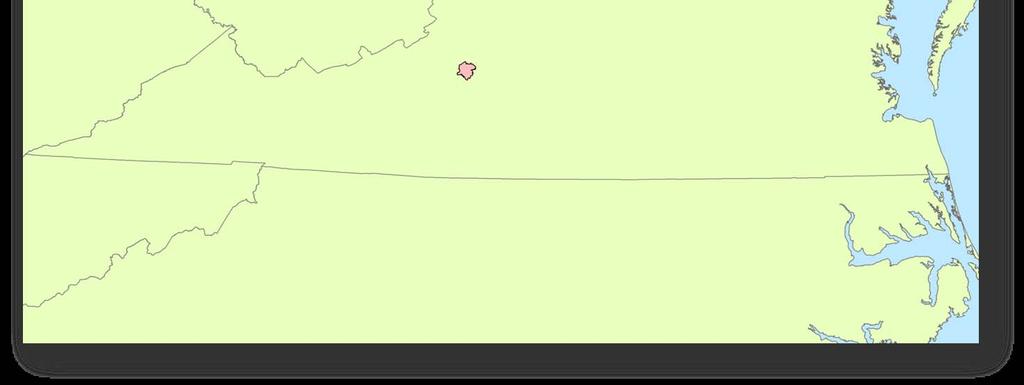
3 Roanoke, Virginia Located in southwest Virginia at the southern end of the Shenandoah Valley Roanoke City Population = 92,238 Roanoke MSA = 295,700 City plus surrounding counties Major health-care consortium is the biggest employer Former headquarters for the N&W Railroad


4 Roanoke, Virginia
5 Violent Crimes All violent crimes reported to the city police for the years Homicides (09A & 09B) All sexual assaults (11 A, B, C,& D) All Robberies (120) Assaults (13 A & B) Aggravated & Simple Assault N = 9549 violent crimes 99.6% nominal geocoding rate
6 Crime rates Measuring Crime Standardized for population at risk and modified by a constant to improve understanding (crimes per 100,000) Problems with traditional rates The denominator problem The Modifiable Areal Unit Problem Low population in a large area distorts the rate Typically constrained to census areas Tracts, block groups, or blocks (rarely)
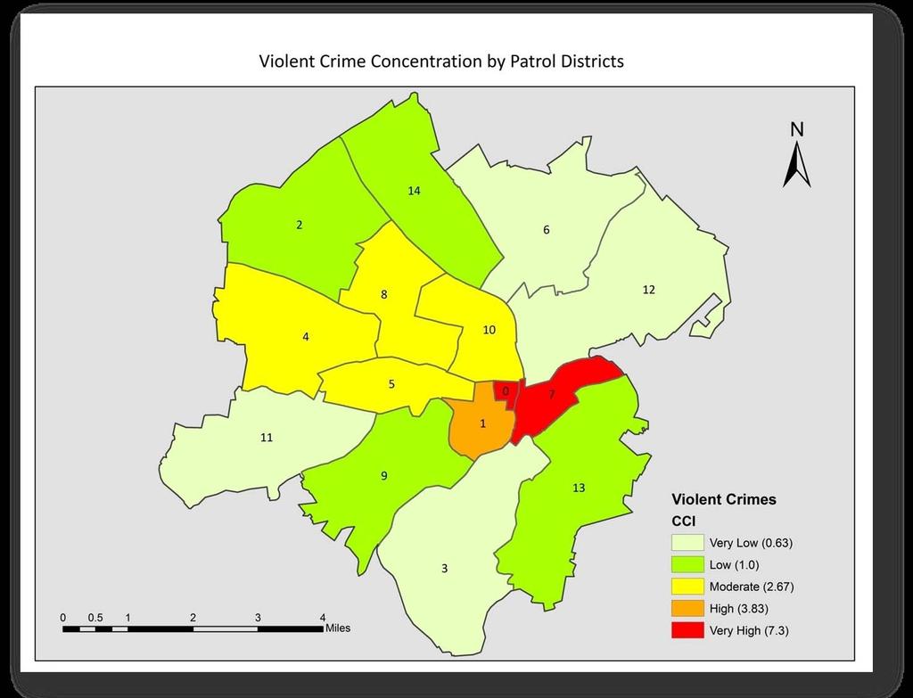
7 The Crime Concentration Index (CCI) An adaptation of the location quotient to the study of crime Provides a risk estimator not contingent on an uncertain population at risk Solves the denominator problem CCIs are based on the comparison between the mix of recorded offences in a specific area and the mix of offences in a broader area
8 The Crime Concentration Index CCI Incidents = n = Area i n i N n 1 N n = 1 Incidents Area i n i n Incidents = violent crimes per unit area Area = area (in sq mi) of polygon
9 The Crime Concentration Index Provides a relative concentration index based on the total distribution of crime A value of 1.0 is the baseline Values less than 1.0 indicate crime is less concentrated in that area Values greater than 1.0 indicate crime is more concentrated in that area Can be read as a percentage
10 Use of spatial autocorrelation (Moran s I) to test for spatial nonrandomness. As values depart above zero it is less likely the crimes are randomly distributed throughout the study area. ARE THE CRIMES RANDOMLY DISTRIBUTED?

11 Distribution of Violent Crime

12 Test for Clustered Distribution High High Low Low With both indices there is strong evidence of spatial clustering of violent crime

13 LISA:Rate Violent Crimes

14 LISA:CCI Violent Crime
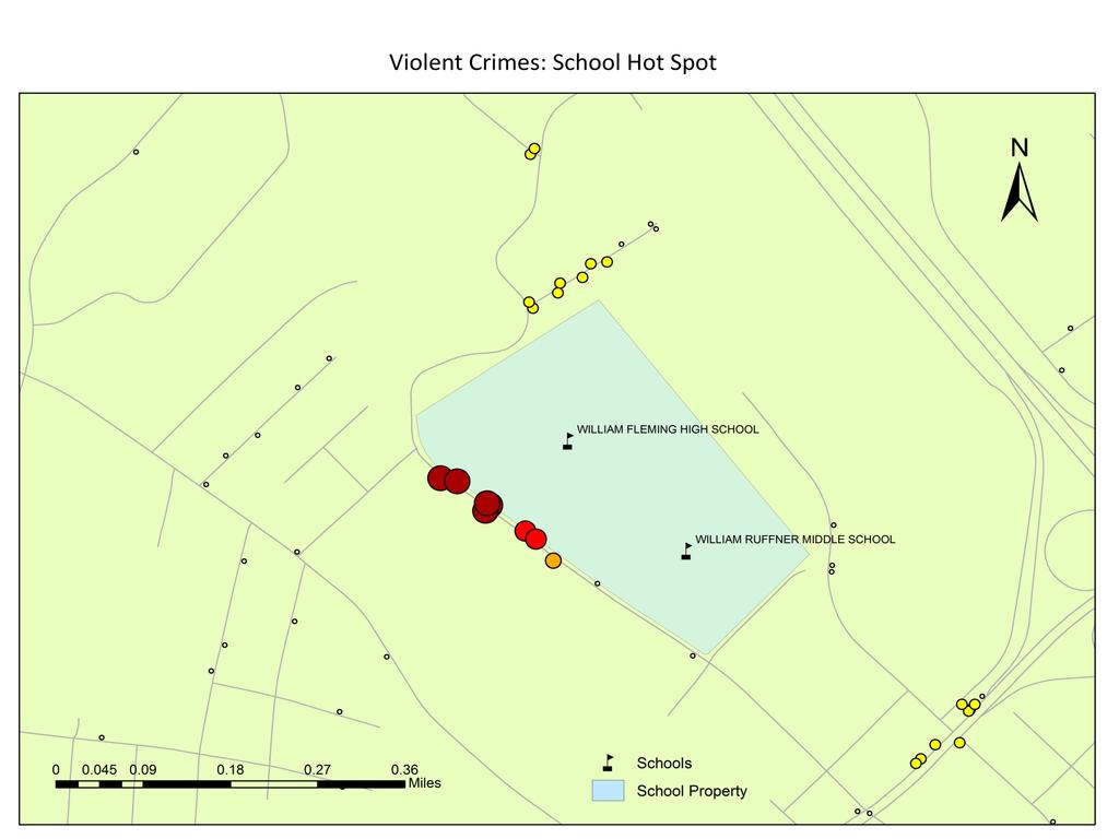
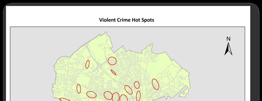
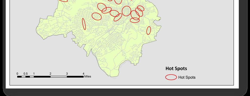
15 Areas where violent crime clusters HOT SPOT ANALYSIS OF VIOLENT CRIME
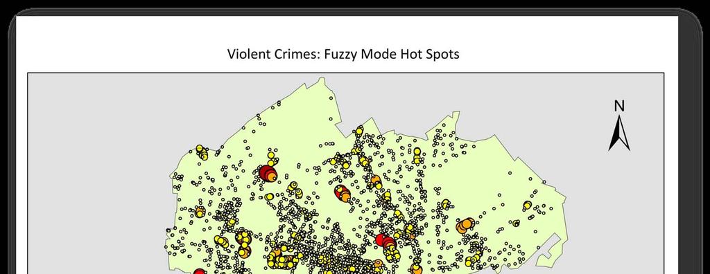
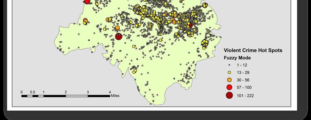
16
17
18
19
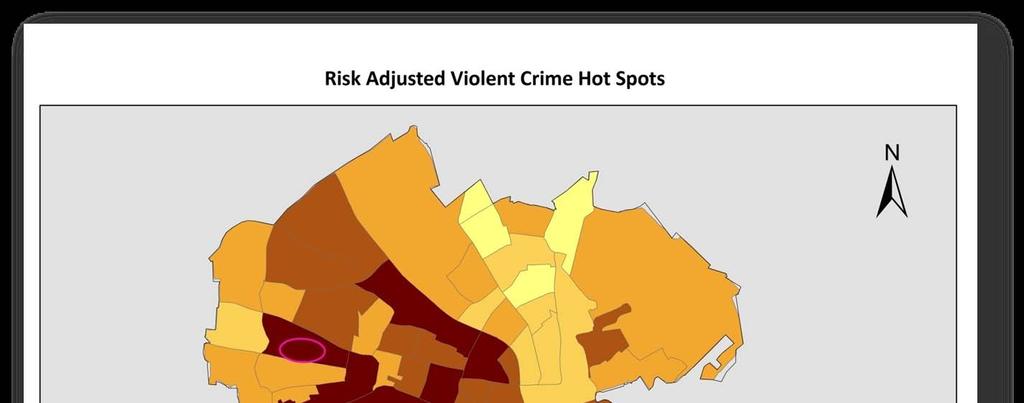
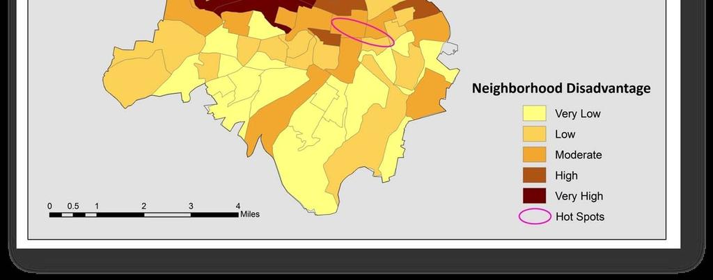
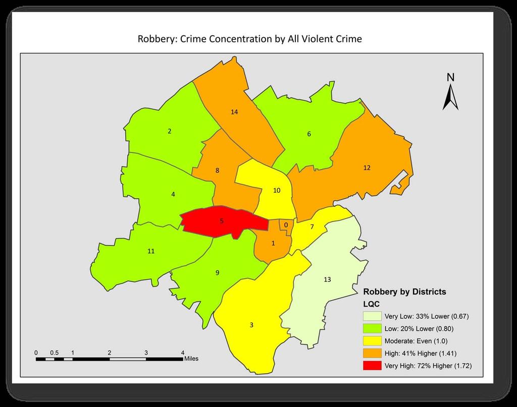
20 Conclusions Violent crime is not randomly distributed throughout the city Specific areas in the city have more clustering hot spots At least two areas of concentration are related to social disorganization in the backcloth
21 This analysis would not be possible with traditional crime rates ANALYSIS OF VIOLENT CRIME BY PATROL DISTRICT

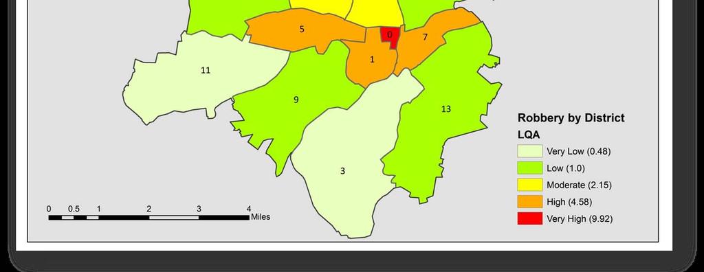
22 Total Area=43 SqMi
23
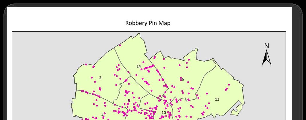
24 During the study period the city experienced a 17.6% increase in robbery ( ). There were 644 robberies during this period. During the period from 2000 until 2006 the city experienced a 77.4% increase in robbery. FOCUS ON ROBBERY
25
26
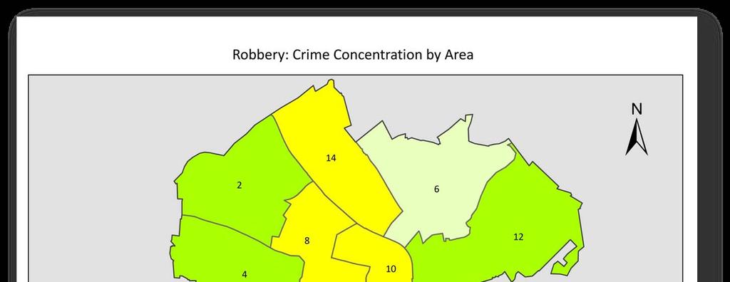
27 Crime Concentration Index CCI by area: concentration in an area CCI by crime: concentration of a specific crime (robbery) compared to the distribution of total crime (violent crimes) CCI Robberies n = = ViolentCrimes i i n N n N n = 1 1 Robberies n ViolentCrimes i i n
28
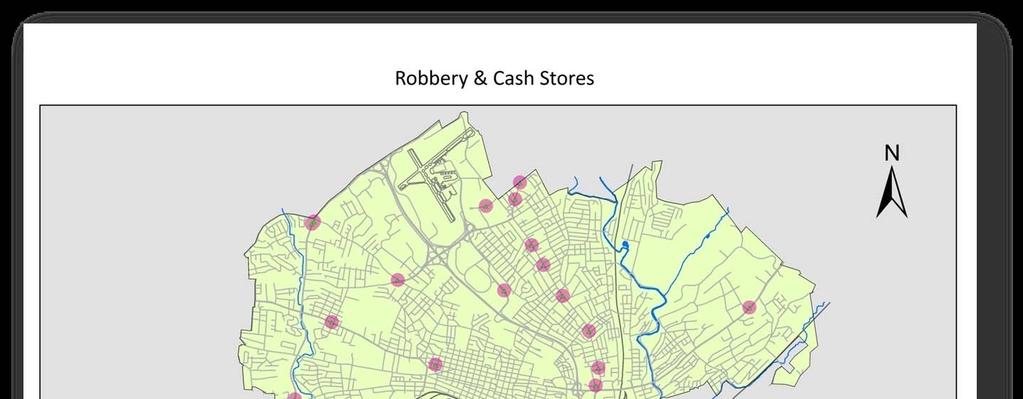
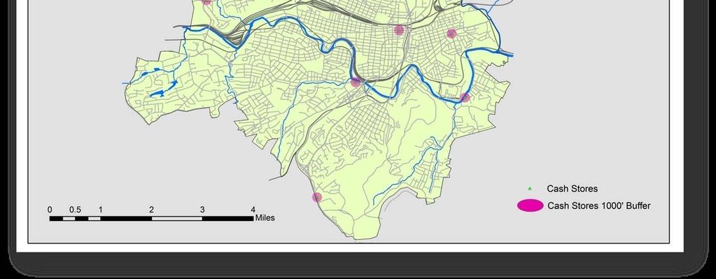
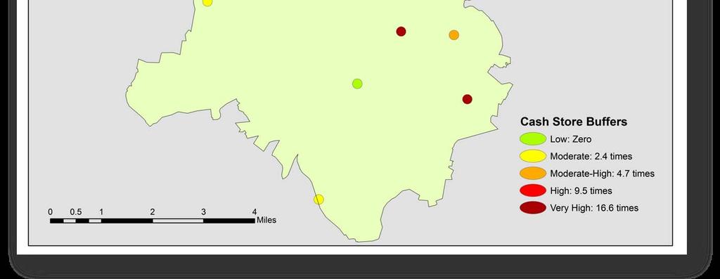
29 Cash Stores & Robbery Cash Stores A business based on the sale of cash: check cashing, pawn, & pay-day lending Customers (often on foot) leave these locations with cash in their pocket Buffered locations Cash store locations plus 1000 buffer 1000 is the distance most people will walk in a city before seeking alternative transportation
30
31 Localized CCI for Robberies CCI = Robbery buffer TotalRobberies Area buffer TotalArea
32
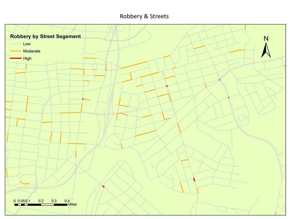
33 Linear Concentration Index Aggregate crimes to street segments with a spatial join Calculate a CCI using segment length rather than area Display the output using color and line width to enhance qualitative understanding
34
35 Conclusions Violent Crime is not randomly distributed and clusters near the city center Crime concentration indices are a better method for examining the distribution of crime at the micro-spatial level CCIs have flexibility in their application which allow for the study of crime from different perspectives

36 Questions? If I can help: Isaac T. Van Patten at ivanpatt@radford.edu These slides will be available at:
Environmental Criminology
 ENVIRONMENTAL CRIMINOLOGY AND THE IMPACT OF PROBLEM BUSINESSES ON CRIME IN PORTLAND NEIGHBORHOODS Presented by Ryan Arnold Hector Osuna Allen Byrd Environmental Criminology Annually crime plays a large
EICCARS WORKBOOK FOR INITIATING COMMUNITY PROFILES WITH STATISTICAL AND OTHER SECONDARY DATA
 The Cultural Ecology of Health and Change (CEHC) Working Papers Ethnographically Informed Community and Cultural Assessment Research Systems (EICCARS) Workbooks EICCARS WORKBOOK FOR INITIATING COMMUNITY
Manual of Crime Analysis Map Production
 Manual of Crime Analysis Map Production Manual of Crime Analysis Map Production Written by: Mary Velasco Research Associate, Crime Mapping Laboratory and Rachel Boba, Ph.D. Director, Crime Mapping Laboratory
GIS Spatial Statistics for Public Opinion Survey Response Rates
 GIS Spatial Statistics for Public Opinion Survey Response Rates July 22, 2015 Timothy Michalowski Senior Statistical GIS Analyst Abt SRBI - New York, NY t.michalowski@srbi.com www.srbi.com Introduction
Nature of Spatial Data. Outline. Spatial Is Special
 Nature of Spatial Data Outline Spatial is special Bad news: the pitfalls of spatial data Good news: the potentials of spatial data Spatial Is Special Are spatial data special? Why spatial data require
GIS and the Built Environment
 GIS and the Built Environment GIS Workshop Active Living Research Conference February 9, 2010 Anne Vernez Moudon, Dr. es Sc. University of Washington Chanam Lee, Ph.D., Texas A&M University OBJECTIVES
Data Driven Approaches to Crime and Traffic Safety
 Data Driven Approaches to Crime and Traffic Safety Baltimore County Police Department Traffic Safety is Public Safety Baltimore County Police Department Population: 801,000 Square Miles: 610 Sworn Personnel:
What Explains the Effectiveness of Hot Spots Policing And What New Strategies Should we Employ?
 What Explains the Effectiveness of Hot Spots Policing And What New Strategies Should we Employ? David Weisburd Executive Director Center for Evidence-Based Crime Policy George Mason 1 The Effectiveness
WlLPEN L. GORR KRISTEN S. KURLAND. Universitats- und Landesbibliothek. Bibliothek Architektur und Stadtebau ESRI
 hj WlLPEN L. GORR KRISTEN S. KURLAND Universitats- und Landesbibliothek Darmstadt Bibliothek Architektur und Stadtebau ESRI Contents Acknowledgments Preface xvii XV GIS Tutorial 1 Introduction Launch ArcMap
Exploring the Impact of Ambient Population Measures on Crime Hotspots
 Exploring the Impact of Ambient Population Measures on Crime Hotspots Nick Malleson School of Geography, University of Leeds http://nickmalleson.co.uk/ N.S.Malleson@leeds.ac.uk Martin Andresen Institute
Everything is related to everything else, but near things are more related than distant things.
 SPATIAL ANALYSIS DR. TRIS ERYANDO, MA Everything is related to everything else, but near things are more related than distant things. (attributed to Tobler) WHAT IS SPATIAL DATA? 4 main types event data,
Spatial Analysis 1. Introduction
 Spatial Analysis 1 Introduction Geo-referenced Data (not any data) x, y coordinates (e.g., lat., long.) ------------------------------------------------------ - Table of Data: Obs. # x y Variables -------------------------------------
ROBBERY VULNERABILITY
 Spatial Risk Assessment: ROBBERY VULNERABILITY A Spatial Risk Assessment was conducted to identify environmental features which make locations conducive to robberies in the City of Burlington, NC. Findings
Introducing GIS analysis
 1 Introducing GIS analysis GIS analysis lets you see patterns and relationships in your geographic data. The results of your analysis will give you insight into a place, help you focus your actions, or
This report details analyses and methodologies used to examine and visualize the spatial and nonspatial
 Analysis Summary: Acute Myocardial Infarction and Social Determinants of Health Acute Myocardial Infarction Study Summary March 2014 Project Summary :: Purpose This report details analyses and methodologies
Linking Neighbourhood Data in the Analysis of Crime
 Linking Neighbourhood Data in the Analysis of Crime Professor Susan McVie University of Edinburgh CEBCP-SIPR Joint Symposium 8 th April 2013 The importance of crime mapping for policing in UK Understanding
Types of spatial data. The Nature of Geographic Data. Types of spatial data. Spatial Autocorrelation. Continuous spatial data: geostatistics
 The Nature of Geographic Data Types of spatial data Continuous spatial data: geostatistics Samples may be taken at intervals, but the spatial process is continuous e.g. soil quality Discrete data Irregular:
Exploring the Relationship Between Vacant and Distressed Properties and Community Health and Safety
 Exploring the Relationship Between Vacant and Distressed Properties and Community Health and Safety Prepared for: Western Reserve Land Conservancy Prepared by: Center on Urban Poverty and Community Development
Luc Anselin Spatial Analysis Laboratory Dept. Agricultural and Consumer Economics University of Illinois, Urbana-Champaign
 GIS and Spatial Analysis Luc Anselin Spatial Analysis Laboratory Dept. Agricultural and Consumer Economics University of Illinois, Urbana-Champaign http://sal.agecon.uiuc.edu Outline GIS and Spatial Analysis
Spatial Data, Spatial Analysis and Spatial Data Science
 Spatial Data, Spatial Analysis and Spatial Data Science Luc Anselin http://spatial.uchicago.edu 1 spatial thinking in the social sciences spatial analysis spatial data science spatial data types and research
Comparison of spatial methods for measuring road accident hotspots : a case study of London
 Journal of Maps ISSN: (Print) 1744-5647 (Online) Journal homepage: http://www.tandfonline.com/loi/tjom20 Comparison of spatial methods for measuring road accident hotspots : a case study of London Tessa
Innovation in the Measurement of Place: Systematic Social Observation in a Rural Setting
 Innovation in the Measurement of Place: Systematic Social Observation in a Rural Setting Barbara Entwisle Heather Edelblute Brian Frizzelle Phil McDaniel September 21, 2009 Background Hundreds of studies
Using GIS to Explore the Relationship between Socioeconomic Status and Demographic Variables and Crime in Pittsburgh, Pennsylvania
 Using GIS to Explore the Relationship between Socioeconomic Status and Demographic Variables and Crime in Pittsburgh, Pennsylvania Stephen E. Mitchell Department of Resource Analysis, Saint Mary s University
Introduction: Name Redacted November 17, 2017 GSP 370 Research Proposal and Literature Review
 Name Redacted November 17, 2017 GSP 370 Research Proposal and Literature Review Introduction: The study of spatial patterns and distributions has been conducted for many years. Over the last few decades,
Acknowledgments xiii Preface xv. GIS Tutorial 1 Introducing GIS and health applications 1. What is GIS? 2
 Acknowledgments xiii Preface xv GIS Tutorial 1 Introducing GIS and health applications 1 What is GIS? 2 Spatial data 2 Digital map infrastructure 4 Unique capabilities of GIS 5 Installing ArcView and the
The spatial-temporal prediction of various crime types in Houston, TX based on hot-spot techniques
 Louisiana State University LSU Digital Commons LSU Master's Theses Graduate School 2014 The spatial-temporal prediction of various crime types in Houston, TX based on hot-spot techniques Shuzhan Fan Louisiana
Locational Error Impacts on Local Spatial Autocorrelation Indices: A Syracuse Soil Sample Pb-level Data Case Study
 Locational Error Impacts on Local Spatial Autocorrelation Indices: A Syracuse Soil Sample Pb-level Data Case Study Daniel A. Griffith *1, Yongwan Chun 1, and Monghyeon Lee 1 1 University of Texas at Dallas,
- Geography is important when studying crime because when a crime happens it always has a location, a time and a reason.
 - Geography is important when studying crime because when a crime happens it always has a location, a time and a reason. - Crime figures are collected from the number of crime incidents reported to the
Chapter 1 Introducing GIS for police work
 Chapter 1 Introducing GIS for police work Introduction This chapter introduces crime mapping and analysis using Esri s ArcGIS Desktop for meeting the day-to-day information needs of police organizations.
Hierarchical Additive Modeling of Nonlinear Association with Spatial Correlations
 1 ENAR09 LSUHSC p. 1/18 Hierarchical Additive Modeling of Nonlinear Association with Spatial Correlations Qingzhao Yu, Bin Li, Richard Scribner Louisiana State University, School of Public Health Supported
Analysis of Violent Crime in Los Angeles County
 Analysis of Violent Crime in Los Angeles County Xiaohong Huang UID: 004693375 March 20, 2017 Abstract Violent crime can have a negative impact to the victims and the neighborhoods. It can affect people
Outline. Practical Point Pattern Analysis. David Harvey s Critiques. Peter Gould s Critiques. Global vs. Local. Problems of PPA in Real World
 Outline Practical Point Pattern Analysis Critiques of Spatial Statistical Methods Point pattern analysis versus cluster detection Cluster detection techniques Extensions to point pattern measures Multiple
Development of Crime Forecasting and Mapping Systems for Use by Police
 i Final Report Development of Crime Forecasting and Mapping Systems for Use by Police 2001-IJ-CX-0018 By Jacqueline Cohen Wilpen L. Gorr August 10, 2005 H. John Heinz III School of Public Policy and Management
Finding Hot Spots in ArcGIS Online: Minimizing the Subjectivity of Visual Analysis. Nicholas M. Giner Esri Parrish S.
 Finding Hot Spots in ArcGIS Online: Minimizing the Subjectivity of Visual Analysis Nicholas M. Giner Esri Parrish S. Henderson FBI Agenda The subjectivity of maps What is Hot Spot Analysis? Why do Hot
Are You Maximizing The Value Of All Your Data?
 Are You Maximizing The Value Of All Your Data? Using The SAS Bridge for ESRI With ArcGIS Business Analyst In A Retail Market Analysis SAS and ESRI: Bringing GIS Mapping and SAS Data Together Presented
GIS Level 2. MIT GIS Services
 GIS Level 2 MIT GIS Services http://libraries.mit.edu/gis Email: gishelp@mit.edu TOOLS IN THIS WORKSHOP - Definition Queries - Create a new field in the attribute table - Field Calculator - Add XY Data
Evaluating Sex Offender Exclusion Laws Alan Murray
 Evaluating Sex Offender Exclusion Laws Alan Murray Center for Urban and Regional Analysis and Department of Geography Ohio State University Columbus, OH 43210, USA Email: murray.308@osu.edu Outline Context
MEMPHIS POLICE DEPARTMENT
 MEMPHIS POLICE DEPARTMENT Sentinel Camera Project City Council Districts (Data Dates Jan. 1 Dec. 31, 2016) District 1 - Councilman Bill Morrison District 2 - Councilman Frank Colvett District 3 Councilwoman
Inclusion of Non-Street Addresses in Cancer Cluster Analysis
 Inclusion of Non-Street Addresses in Cancer Cluster Analysis Sue-Min Lai, Zhimin Shen, Darin Banks Kansas Cancer Registry University of Kansas Medical Center KCR (Kansas Cancer Registry) KCR: population-based
Lecture 4. Spatial Statistics
 Lecture 4 Spatial Statistics Lecture 4 Outline Statistics in GIS Spatial Metrics Cell Statistics Neighborhood Functions Neighborhood and Zonal Statistics Mapping Density (Density surfaces) Hot Spot Analysis
Introducing spatial measurements and statistics
 1 Introducing spatial measurements and statistics Spatial measurements and statistics allow you to quantify patterns and relationships. That makes it easier to compare sets of features and to track changes
Mapping Your Educational Research: Putting Spatial Concepts into Practice with GIS. Mark Hogrebe Washington University in St.
 Mapping Your Educational Research: Putting Spatial Concepts into Practice with GIS Mapping Your Educational Research: Putting Spatial Concepts into Practice with GIS Mark Hogrebe Washington University
Geog183: Cartographic Design and Geovisualization Winter Quarter 2017 Lecture 6: Map types and Data types
 Geog183: Cartographic Design and Geovisualization Winter Quarter 2017 Lecture 6: Map types and Data types Data types Data dimension: Point, Line, Area, Volume (Text) Data continuity: Discrete, Point, Polygon:
GIS Test Drive What a Geographic Information System Is and What it Can Do. Alison Davis-Holland
 GIS Test Drive What a Geographic Information System Is and What it Can Do Alison Davis-Holland adavisholland@gmail.com WHO AM I? Geospatial Analyst M.S. in Geographic and Cartographic Sciences Use GIS
Modeling the Ecology of Urban Inequality in Space and Time
 Modeling the Ecology of Urban Inequality in Space and Time Corina Graif PhD Candidate, Department Of Sociology Harvard University Presentation for the Workshop on Spatial and Temporal Modeling, Center
Crime Analysis. GIS Solutions for Intelligence-Led Policing
 Crime Analysis GIS Solutions for Intelligence-Led Policing Applying GIS Technology to Crime Analysis Know Your Community Analyze Your Crime Use Your Advantage GIS aids crime analysis by Identifying and
GIS for the Non-Expert
 GIS for the Non-Expert Ann Forsyth University of Minnesota February 2006 GIS for the Non-Expert 1. Definitions and problems 2. Measures being tested in Twin Cities Walking Study Basic approach, data, variables
CRP 608 Winter 10 Class presentation February 04, Senior Research Associate Kirwan Institute for the Study of Race and Ethnicity
 CRP 608 Winter 10 Class presentation February 04, 2010 SAMIR GAMBHIR SAMIR GAMBHIR Senior Research Associate Kirwan Institute for the Study of Race and Ethnicity Background Kirwan Institute Our work Using
Migration Clusters in Brazil: an Analysis of Areas of Origin and Destination Ernesto Friedrich Amaral
 1 Migration Clusters in Brazil: an Analysis of Areas of Origin and Destination Ernesto Friedrich Amaral Research question and data The main goal of this research is to analyze whether the pattern of concentration
2008 ESRI Business GIS Summit Spatial Analysis for Business 2008 Program
 A GIS Framework F k to t Forecast F t Residential Home Prices By Mak Kaboudan and Avijit Sarkar University of Redlands School of Business 2008 ESRI Business GIS Summit Spatial Analysis for Business 2008
Finding Hot Spots in ArcGIS Online: Minimizing the Subjectivity of Visual Analysis. Nicholas M. Giner Esri Parrish S.
 Finding Hot Spots in ArcGIS Online: Minimizing the Subjectivity of Visual Analysis Nicholas M. Giner Esri Parrish S. Henderson - FBI Agenda The subjectivity of maps What is Hot Spot Analysis? What is Outlier
Mapping For Wellness: Then and Now
 Mapping For Wellness: Then and Now John Ritter, Ph.D. Geomatics Dept. Oregon Institute of Technology Klamath Falls, OR 97601 John.Ritter@oit.edu Sponsors 1 Objectives Understand how medical mapping can
Linking Industry and Occupation Clusters in Regional Economic Development
 Linking Industry and Occupation Clusters in Regional Economic Development Charting the Course for Regional Development: First Annual EDA Economic Development Research Symposium Clarion Hotel Morgan Morgantown,
Spatial segregation and socioeconomic inequalities in health in major Brazilian cities. An ESRC pathfinder project
 Spatial segregation and socioeconomic inequalities in health in major Brazilian cities An ESRC pathfinder project Income per head and life-expectancy: rich & poor countries Source: Wilkinson & Pickett,
UC POLICE DEPARTMENT REPORTS DASHBOARD
 UC POLICE DEPARTMENT REPORTS DASHBOARD UC MERCED Annual 1. UC Merced FBI Part I Crime Offenses 2 2. UC Merced FBI Part II Crime Offenses 3 3. UC Merced Arrests - FBI Crime Offenses 4 4. UC Merced Value
Examining the extent to which hotspot analysis can support spatial predictions of crime
 Examining the extent to which hotspot analysis can support spatial predictions of crime Spencer Paul Chainey Thesis submitted in accordance with the requirements of the Degree of Doctor of Philosophy University
Making Our Cities Safer: A Study In Neighbhorhood Crime Patterns
 Making Our Cities Safer: A Study In Neighbhorhood Crime Patterns Aly Kane alykane@stanford.edu Ariel Sagalovsky asagalov@stanford.edu Abstract Equipped with an understanding of the factors that influence
GIST 4302/5302: Spatial Analysis and Modeling Lecture 2: Review of Map Projections and Intro to Spatial Analysis
 GIST 4302/5302: Spatial Analysis and Modeling Lecture 2: Review of Map Projections and Intro to Spatial Analysis Guofeng Cao http://www.spatial.ttu.edu Department of Geosciences Texas Tech University guofeng.cao@ttu.edu
Monsuru Adepeju 1 and Andy Evans 2. School of Geography, University of Leeds, LS21 1HB 1
 Investigating the impacts of training data set length (T) and the aggregation unit size (M) on the accuracy of the self-exciting point process (SEPP) hotspot method Monsuru Adepeju 1 and Andy Evans 2 1,
Few studies have combined factors related to social disorganisation and
 A Micro-Spatial Analysis of the Demographic and Criminogenic Environment of Drug Markets in Philadelphia Eric S. McCord and Jerry H. Ratcliffe Temple University, United States of America Few studies have
ArcGIS 9.0 Crime Mapping Workbook. We have now arrived at the workbook section of the textbook. The workbook is
 ArcGIS 9.0 Crime Mapping Workbook Introduction We have now arrived at the workbook section of the textbook. The workbook is designed to provide students with a hands-on method for learning the basics of
Testing the Law of Crime Concentration at Place in a Suburban Setting: Implications for Research and Practice
 DOI 10.1007/s10940-016-9304-y ORIGINAL PAPER Testing the Law of Crime Concentration at Place in a Suburban Setting: Implications for Research and Practice Charlotte Gill 1 Alese Wooditch 2 David Weisburd
Guilty of committing ecological fallacy?
 GIS: Guilty of committing ecological fallacy? David W. Wong Professor Geography and GeoInformation Science George Mason University dwong2@gmu.edu Ecological Fallacy (EF) Many slightly different definitions
Regional Snapshot Series: Transportation and Transit. Commuting and Places of Work in the Fraser Valley Regional District
 Regional Snapshot Series: Transportation and Transit Commuting and Places of Work in the Fraser Valley Regional District TABLE OF CONTENTS Complete Communities Daily Trips Live/Work Ratio Commuting Local
CALOTS Upgrade for Performance Monitoring
 CALOTS Upgrade for Performance Monitoring A project of the Southern California Association of Governments supported by the UCLA Lewis Center for Regional Policy Studies Agenda 1. Revisit Project Overview
MODULE 12: Spatial Statistics in Epidemiology and Public Health Lecture 7: Slippery Slopes: Spatially Varying Associations
 MODULE 12: Spatial Statistics in Epidemiology and Public Health Lecture 7: Slippery Slopes: Spatially Varying Associations Jon Wakefield and Lance Waller 1 / 53 What are we doing? Alcohol Illegal drugs
Neighborhood social characteristics and chronic disease outcomes: does the geographic scale of neighborhood matter? Malia Jones
 Neighborhood social characteristics and chronic disease outcomes: does the geographic scale of neighborhood matter? Malia Jones Prepared for consideration for PAA 2013 Short Abstract Empirical research
compass.durhamnc.gov Building Community by Illustrating Community Durham s Neighborhood Compass
 Building Community by Illustrating Community Durham s Neighborhood Compass A presentation by John Killeen Rob Cushman Tyler Waring Neighborhood Improvement Services & Technology Solutions City of Durham,
Tracey Farrigan Research Geographer USDA-Economic Research Service
 Rural Poverty Symposium Federal Reserve Bank of Atlanta December 2-3, 2013 Tracey Farrigan Research Geographer USDA-Economic Research Service Justification Increasing demand for sub-county analysis Policy
The Effects of Place Centric Crime Reduction Efforts In Three Neighborhoods Appendix
 The Effects of Place Centric Crime Reduction Efforts In Three Neighborhoods Appendix Francisca Winston January 31, 2017 This Appendix accompanies The Effects of Place Centric Crime Reduction Efforts in
Appendixx C Travel Demand Model Development and Forecasting Lubbock Outer Route Study June 2014
 Appendix C Travel Demand Model Development and Forecasting Lubbock Outer Route Study June 2014 CONTENTS List of Figures-... 3 List of Tables... 4 Introduction... 1 Application of the Lubbock Travel Demand
Developing an Analysis Process for Crime Hot Spot Identification and Comparison
 Developing an Analysis Process for Crime Hot Spot Identification and Comparison Joseph M. Dick and Matthew S. Dick Department of Resource Analysis, Saint Mary s University of Minnesota, Minneapolis, MN
Defining Statistically Significant Spatial Clusters of a Target Population using a Patient-Centered Approach within a GIS
 Defining Statistically Significant Spatial Clusters of a Target Population using a Patient-Centered Approach within a GIS Efforts to Improve Quality of Care Stephen Jones, PhD Bio-statistical Research
Mapping and Analysis for Spatial Social Science
 Mapping and Analysis for Spatial Social Science Luc Anselin Spatial Analysis Laboratory Dept. Agricultural and Consumer Economics University of Illinois, Urbana-Champaign http://sal.agecon.uiuc.edu Outline
SPATIAL ANALYSIS. Transformation. Cartogram Central. 14 & 15. Query, Measurement, Transformation, Descriptive Summary, Design, and Inference
 14 & 15. Query, Measurement, Transformation, Descriptive Summary, Design, and Inference Geographic Information Systems and Science SECOND EDITION Paul A. Longley, Michael F. Goodchild, David J. Maguire,
Map your way to deeper insights
 Map your way to deeper insights Target, forecast and plan by geographic region Highlights Apply your data to pre-installed map templates and customize to meet your needs. Select from included map files
Area-Specific Crime Prediction Models
 Area-Specific Crime Prediction Models Mohammad Al Boni and Matthew S. Gerber Department of Systems and Information Engineering, University of Virginia, Charlottesville, Virginia, USA Email: {ma2sm, msg8u}@virginia.edu
Space and the City: Modern Chicago (and Beyond)
") Space and the City: Modern Chicago (and Beyond) Robert J. Sampson Department of Sociology Harvard University Concentration of Collective Action Events in Chicago Spatial Interdependence of Concentrated
Space and the City: Modern Chicago (and Beyond) Robert J. Sampson Department of Sociology Harvard University Concentration of Collective Action Events in Chicago Spatial Interdependence of Concentrated
Florida State University Libraries
 Florida State University Libraries Electronic Theses, Treatises and Dissertations The Graduate School 2014 The Concentration of Crime in Cities Across the U.S. Kevin T. Wolff Follow this and additional
LAND USE AND VIOLENT CRIME. Thomas D. Stucky. John R. Ottensmann. School of Public and Environmental Affairs
 Contact Information: Thomas D. Stucky, Ph.D. Associate Professor of Criminal Justice School of Public and Environmental Affairs BS/SPEA Building 4069 801 W. Michigan St. Indianapolis, IN 46202 tstucky@iupui.edu.
Hypothesis Testing hypothesis testing approach
 Hypothesis Testing In this case, we d be trying to form an inference about that neighborhood: Do people there shop more often those people who are members of the larger population To ascertain this, we
Spatial Pattern Analysis: Mapping Trends and Clusters
 Esri International User Conference San Diego, California Technical Workshops July 24, 2012 Spatial Pattern Analysis: Mapping Trends and Clusters Lauren M. Scott, PhD Lauren Rosenshein Bennett, MS Presentation
GIS = Geographic Information Systems;
 What is GIS GIS = Geographic Information Systems; What Information are we talking about? Information about anything that has a place (e.g. locations of features, address of people) on Earth s surface,
Evaluating racial clusters as a unit of aggregation for neighborhood effects. Extended Abstract. Draft. Do not cite.
 Evaluating racial clusters as a unit of aggregation for neighborhood effects. Extended Abstract Draft. Do not cite. Jonathan Tannen Ph.D. Candidate, Princeton University March 24, 2014 Introduction The
Spatial Analysis II. Spatial data analysis Spatial analysis and inference
 Spatial Analysis II Spatial data analysis Spatial analysis and inference Roadmap Spatial Analysis I Outline: What is spatial analysis? Spatial Joins Step 1: Analysis of attributes Step 2: Preparing for
DIFFERENT INFLUENCES OF SOCIOECONOMIC FACTORS ON THE HUNTING AND FISHING LICENSE SALES IN COOK COUNTY, IL
 DIFFERENT INFLUENCES OF SOCIOECONOMIC FACTORS ON THE HUNTING AND FISHING LICENSE SALES IN COOK COUNTY, IL Xiaohan Zhang and Craig Miller Illinois Natural History Survey University of Illinois at Urbana
In this exercise we will learn how to use the analysis tools in ArcGIS with vector and raster data to further examine potential building sites.
 GIS Level 2 In the Introduction to GIS workshop we filtered data and visually examined it to determine where to potentially build a new mixed use facility. In order to get a low interest loan, the building
The CrimeStat Program: Characteristics, Use, and Audience
 The CrimeStat Program: Characteristics, Use, and Audience Ned Levine, PhD Ned Levine & Associates and Houston-Galveston Area Council Houston, TX In the paper and presentation, I will discuss the CrimeStat
Medical GIS: New Uses of Mapping Technology in Public Health. Peter Hayward, PhD Department of Geography SUNY College at Oneonta
 Medical GIS: New Uses of Mapping Technology in Public Health Peter Hayward, PhD Department of Geography SUNY College at Oneonta Invited research seminar presentation at Bassett Healthcare. Cooperstown,
Profiling Burglary in London using Geodemographics
 Profiling Burglary in London using Geodemographics C G Gale *1, A D Singleton 2 and P A Longley 3 1 UCL Department of Civil, Environmental & Geomatic Engineering 2 University of Liverpool Department of
Lorie Velarde & Kim Rossmo
 Basic Geographic Profiling Analyst Training Lorie Velarde & Kim Rossmo Day One Administration and Introduction Overview of Week o Environmental Criminology o Geography of Crime o Search Exercise o Mathematical
from
 8Map Generalization and Classification Our human and natural environments are complex and full of detail. Maps work by strategically reducing detail and grouping phenomena together. Driven by your intent,
The Choropleth Map Slide #2: Choropleth mapping enumeration units
 The Choropleth Map Slide #2: Choropleth mapping is a common technique for representing enumeration data These are maps where enumeration units, such as states or countries, are shaded a particular color
Spatiotemporal Analysis of Urban Traffic Accidents: A Case Study of Tehran City, Iran
 Spatiotemporal Analysis of Urban Traffic Accidents: A Case Study of Tehran City, Iran January 2018 Niloofar HAJI MIRZA AGHASI Spatiotemporal Analysis of Urban Traffic Accidents: A Case Study of Tehran
How GIS Can Help With Tribal Safety Planning
 How GIS Can Help With Tribal Safety Planning Thomas A. Horan, PhD Brian Hilton, PhD Arman Majidi, MAIS Center for Information Systems and Technology Claremont Graduate University Goals & Objectives This
Spatial Pattern of Burglary in South Yorkshire Using Geographic Information System (GIS)
") International Journal of Astrophysics and Space Science 2016; 4(1): 1-11 Published online January 22, 2016 (http://www.sciencepublishinggroup.com/j/ijass) doi: 10.11648/j.ijass.20160401.11 ISSN: 2376-7014
International Journal of Astrophysics and Space Science 2016; 4(1): 1-11 Published online January 22, 2016 (http://www.sciencepublishinggroup.com/j/ijass) doi: 10.11648/j.ijass.20160401.11 ISSN: 2376-7014
The Journal of Database Marketing, Vol. 6, No. 3, 1999, pp Retail Trade Area Analysis: Concepts and New Approaches
 Retail Trade Area Analysis: Concepts and New Approaches By Donald B. Segal Spatial Insights, Inc. 4938 Hampden Lane, PMB 338 Bethesda, MD 20814 Abstract: The process of estimating or measuring store trade
Spatial Analysis I. Spatial data analysis Spatial analysis and inference
 Spatial Analysis I Spatial data analysis Spatial analysis and inference Roadmap Outline: What is spatial analysis? Spatial Joins Step 1: Analysis of attributes Step 2: Preparing for analyses: working with
Date: Wed 12 July 2017 Reference Number: FOI Category: Stats - Crime
 Date: Wed 12 July 2017 Reference Number: 20171145 FOI Category: Stats - Crime Title: Hate Crimes Request Date: Friday, 23 June, 2017 Response Date: Wednesday, 12 July, 2017 Request Details: Q1: The total
GIST 4302/5302: Spatial Analysis and Modeling
 GIST 4302/5302: Spatial Analysis and Modeling Lecture 2: Review of Map Projections and Intro to Spatial Analysis Guofeng Cao http://thestarlab.github.io Department of Geosciences Texas Tech University