- Geography is important when studying crime because when a crime happens it always has a location, a time and a reason.
|
|
|
- Easter Mason
- 5 years ago
- Views:
Transcription
1
2 - Geography is important when studying crime because when a crime happens it always has a location, a time and a reason. - Crime figures are collected from the number of crime incidents reported to the police and from the survey results. - The systems of recording crimes are not completely reliable. - When a crime is recorded, it is classified as one of the following: crime against the person (with or without injury), sexual offence, robbery, burglary, offence against vehicles, other theft, fraud and forgery, criminal damage, drug offence, other.
3 Spatial Changes of Criminality in Klaipėda : Social and Territorial Approach - Geography of Crime is a sub-discipline of Human Geography, and focused around the understanding the interplay between crime, space and society through analyses of offences, offenders and the effects of crime. - Studies of the Geography of Crime have their roots in the midnineteenth-century work of European cartographic criminologists who sought to link regional patterns of crime and offender residence to the social and physical environment. - Mapping crime shows where crimes were committed but that does not tell the full story. It is important to understand how crime affects services in the area and communities.
4 Spatial Changes of Criminality in Klaipėda : Social and Territorial Approach - The social disorganization thesis advanced by the Chicago School links deliquency residence to the interrelation between economic deprivation, physical deterioration, high population turnover and cultural fragmentation. - Geography of Crime focused on where crime occurs, involving both the mapping of offences (areal analysis) and to link the distribution of offences to other socio-economic and environmental variables. - An understanding of spatial patterns of victimization and the fear of crime places researchers in a strong position to contribute the public policy via the development and evaluation of crime prevention and fear-reducing measures.
5 Spatial Changes of Criminality in Klaipėda : Social and Territorial Approach The role of space in crime Two key considerations: - Crime has an inherent geographical quality - Crime is not randomly distributed The four dimensions of crime: - Legal (a law must be broken) - Victim (someone or something has to be targeted) - Offender (someone has to do the crime) - Spatial (it has to happen at a place - somewhere, in space and time) If crimes were random: - Equal chance of them happening anywhere at anytime - But crime is not randomly distributed - Concentrated into places of activity - Crime hotspots - Series follow geographic patterns
6 - A progressive blend of practical criminal justice issues with the research field of geographical information systems and science (Chainey and Ratcliffe, 2005). - To date research has been limited to exploring the where and when. - Identifying retrospective concentrations of crime in space and time, and treating space and time discreetly. More robust treatment to the current techniques: Kernel density estimation: influence of cell size and bandwidth - Exploring space and time together - The significance of where and when (spatial significance)
7 -To understand how unusual the crime pattern is. -Why (spatial regression) E.g. relationship between why crime happens where it does against other features. -Not just as a global relationship but as a local relationship. -What if (spatial modelling) E.g. if we target an intervention to a particular place what impact may it have, including displacement and diffusion of benefit effects. - Where and when will it happen again (predictive modelling). - Forecasting, early warning system, predictive crime mapping.
8 Place is important: - Plays a key role for helping to understand and tackle crime problems. - Crime mapping supports many forms of operational, tactical, investigative and strategic policing and crime reduction activity. - Still only scratching the surface in how we exploit the place dimension of crime - Crime mapping has been fundamental in improving police performance in the West Midlands, and in recent months reducing all crime by 20%" Assistant Chief Constable Nick Tofiluk West Midlands Police

9
10 Change of population and crime records in Klaipėda city In inhabitants and crimes recorded 96,7 crimes per inhabitants In ,2 696 In ,5 800 In ,4 248 In ,5 859 In ,4 766 In ,6 188 In ,4 175 In ,6 096 In ,4 537 In ,5 512 In ,5 046 In ,5 812 In ,5 265 In ,5 453 In ,5 692 In ,5 900 In ,5 870 In ,5 542 In ,5 502 In ,5 492 In ,4 643 In ,5 240 In ,5 648 In inhabitants and crimes recorded 356,2 crimes per inhabitants Population decrease - 24,26 % Crimes records increase + 280,7 %
11
12 Spatial Changes of Criminality in Klaipėda : Social and Territorial Approach Methodological issues - Inaccuracy of crime geocoding on micro level in parks, public spaces, industrial sites, non-residential areas - Categories of crime and spatial references against property vs. against person in private place vs. in public space - Changing categories of crime over the time - Social geographic interpretation of crime dynamics What are the underlying social and environmental risk factors that account for spatial occurrence or spatial coincidence of crime? What are the main pitfalls leading to incorrect interpretation of crime in the city?
13
14
15
16
17 Population Crim e records
18 Spatial Changes of Criminality in Klaipėda : Social and Territorial Approach Registered unemployed Crime records

19
20
21
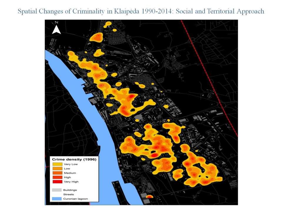
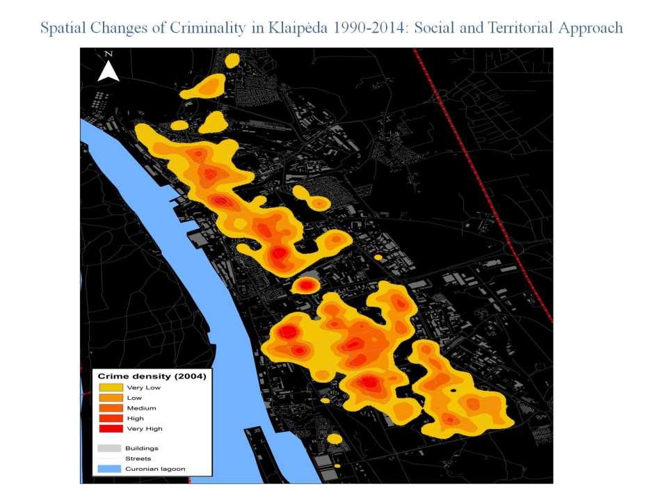
22 Change of Crimes Space in Klaipėda City in Crime trends at the indicated areas of Klaipeda ( ) Bandužiai Debreceno Senamiestis

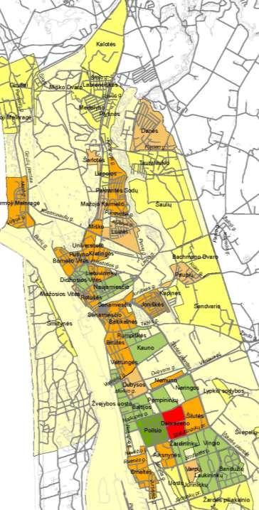
23 Individually distilled alcohol: production and selling places

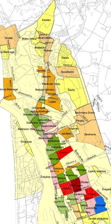
24 Change of Crimes Space in Klaipėda City in Prostitution places
25 Change of Crimes Space in Klaipėda City in Drugs selling places

26 Booze Strange fellowship Drugs Prostitution
27 Change of Crimes Space in Klaipėda City in How to explain the observable? What are the underlying social and territorial factors that account for spatial occurrence or spatial coincidence of crime?
28 Thank you for your attention! Research funded by the Research Council of Lithuania Grant MIP-085/2014 Assoc. Prof. dr. Eduardas Spiriajevas Department of Social Geography Klaipėda University
Examining the extent to which hotspot analysis can support spatial predictions of crime
 Examining the extent to which hotspot analysis can support spatial predictions of crime Spencer Paul Chainey Thesis submitted in accordance with the requirements of the Degree of Doctor of Philosophy University
Introduction: Name Redacted November 17, 2017 GSP 370 Research Proposal and Literature Review
 Name Redacted November 17, 2017 GSP 370 Research Proposal and Literature Review Introduction: The study of spatial patterns and distributions has been conducted for many years. Over the last few decades,
Analysing The Temporal Pattern Of Crime Hotspots In South Yorkshire, United Kingdom
 Advances in Social Sciences Research Journal Vol.5, No.6 Publication Date: June. 25, 218 DoI:1.14738/assrj.56.4822. Abdullahi, H., & Abbas, I. I. (218). Analysing The Temporal Pattern Of Crime Hotspots
Major Crime Map Help Documentation
 Major Crime Map Help Documentation This web application is designed to make it easier to visualize and understand crime trends in Overland Park. The data for this application are generally limited to relatively
Date: Wed 12 July 2017 Reference Number: FOI Category: Stats - Crime
 Date: Wed 12 July 2017 Reference Number: 20171145 FOI Category: Stats - Crime Title: Hate Crimes Request Date: Friday, 23 June, 2017 Response Date: Wednesday, 12 July, 2017 Request Details: Q1: The total
The value of retrospective spatial trends of crime for predictive crime mapping
 The value of retrospective spatial trends of crime for predictive crime mapping Spencer Chainey @SpencerChainey Director of Geographic Information Science University College London Established in 2001
Driving Forces of Houston s Burglary Hotspots During Hurricane Rita
 Driving Forces of Houston s Burglary Hotspots During Hurricane Rita Marco Helbich Department of Geography University of Heidelberg Heidelberg, Germany & Michael Leitner Department of Geography and Anthropology
What Explains the Effectiveness of Hot Spots Policing And What New Strategies Should we Employ?
 What Explains the Effectiveness of Hot Spots Policing And What New Strategies Should we Employ? David Weisburd Executive Director Center for Evidence-Based Crime Policy George Mason 1 The Effectiveness
Dr Spencer Department of Security and Crime Science, University College London
 The Crime Prediction Framework: a spatial temporal framework for targeting patrols, crime prevention and strategic policy National Security Summit, San Diego 18 July 2015 Dr Spencer Chainey @SpencerChainey
Crime Analysis. GIS Solutions for Intelligence-Led Policing
 Crime Analysis GIS Solutions for Intelligence-Led Policing Applying GIS Technology to Crime Analysis Know Your Community Analyze Your Crime Use Your Advantage GIS aids crime analysis by Identifying and
Preprint.
 http://www.diva-portal.org Preprint This is the submitted version of a paper presented at European Intelligence and Security Informatics Conference (EISIC). Citation for the original published paper: Boldt,
Linking Neighbourhood Data in the Analysis of Crime
 Linking Neighbourhood Data in the Analysis of Crime Professor Susan McVie University of Edinburgh CEBCP-SIPR Joint Symposium 8 th April 2013 The importance of crime mapping for policing in UK Understanding
Monsuru Adepeju 1 and Andy Evans 2. School of Geography, University of Leeds, LS21 1HB 1
 Investigating the impacts of training data set length (T) and the aggregation unit size (M) on the accuracy of the self-exciting point process (SEPP) hotspot method Monsuru Adepeju 1 and Andy Evans 2 1,
Percent Change. Last YTD
 Part I L Month Month HOMICIDE 1 0 5 3 66.7% 1 4 3 100.0% 80.0% 100.0% 0 0 0 2 6 8 MURDER 0 0 4 1 300.0% 0 3 1-75.0% 100.0% 0 0 0 2 6 8 MANSLAUGHTER 0 0 0 2-100.0% 0 0 2 - - 100.0% 0 0 0 0 0 0 NEG. HOMICIDE
Medford Police Department April 2018 Consolidated Incident Report(includes all nature of call codes)
") Part I L Month Month HOMICIDE 0 0 2 1 100.0% 0 3 1-150.0% 100.0% 0 0 0 0 5 5 MURDER 0 0 2 1 100.0% 0 2 1-100.0% 100.0% 0 0 0 0 2 2 MANSLAUGHTER 0 0 0 0 0% 0 0 0 - - - 0 0 0 0 0 0 NEG. HOMICIDE - TRAFFIC
Part I L Month Month HOMICIDE 0 0 2 1 100.0% 0 3 1-150.0% 100.0% 0 0 0 0 5 5 MURDER 0 0 2 1 100.0% 0 2 1-100.0% 100.0% 0 0 0 0 2 2 MANSLAUGHTER 0 0 0 0 0% 0 0 0 - - - 0 0 0 0 0 0 NEG. HOMICIDE - TRAFFIC
Percent Change. Last YTD MANSLAUGHTER % % 100.0% JUST. HOMICIDE %
 Part I L Month Month HOMICIDE 1 0 3 1 200.0% 2 4 1 200.0% 133.3% 100.0% 0 2 2 0 4 4 MURDER 0 0 1 1-1 2 1-200.0% 100.0% 0 0 0 0 1 1 MANSLAUGHTER 1 0 2 0 200% 1 2 0 100.0% 100.0% - 0 2 2 0 3 3 JUST. HOMICIDE
Comparison of spatial methods for measuring road accident hotspots : a case study of London
 Journal of Maps ISSN: (Print) 1744-5647 (Online) Journal homepage: http://www.tandfonline.com/loi/tjom20 Comparison of spatial methods for measuring road accident hotspots : a case study of London Tessa
Please see the attached document in relation to your Freedom of Information request.
 Our ref: 375/16 Please send me: all statistics for the last 3 years and the information to be broken down into years and months. I require national and regional statistics (UK, West Yorkshire, Leeds).
Exploring the Impact of Ambient Population Measures on Crime Hotspots
 Exploring the Impact of Ambient Population Measures on Crime Hotspots Nick Malleson School of Geography, University of Leeds http://nickmalleson.co.uk/ N.S.Malleson@leeds.ac.uk Martin Andresen Institute
Manual of Crime Analysis Map Production
 Manual of Crime Analysis Map Production Manual of Crime Analysis Map Production Written by: Mary Velasco Research Associate, Crime Mapping Laboratory and Rachel Boba, Ph.D. Director, Crime Mapping Laboratory
Area-Specific Crime Prediction Models
 Area-Specific Crime Prediction Models Mohammad Al Boni and Matthew S. Gerber Department of Systems and Information Engineering, University of Virginia, Charlottesville, Virginia, USA Email: {ma2sm, msg8u}@virginia.edu
Developing an Analysis Process for Crime Hot Spot Identification and Comparison
 Developing an Analysis Process for Crime Hot Spot Identification and Comparison Joseph M. Dick and Matthew S. Dick Department of Resource Analysis, Saint Mary s University of Minnesota, Minneapolis, MN
LEWISVILLE POLICE DEPARTMENT
 STATISTICAL REPORT FOR THE MONTH OF RUSSELL KERBOW CHIEF OF POLICE PREPARED BY: ROBIN BRIZENDINE PUBLIC SAFETY DATA TECHNICIAN DATE PREPARED: September 20, 2017 ORI: TX0610600 AGENCY: LEWISVILLE STATE:
Seasonality in recorded crime: preliminary findings
 Seasonality in recorded crime: preliminary findings Celia Hird Chandni Ruparel Home Office Online Report /7 The views expressed in this report are those of the authors, not necessarily those of the Home
Detecting Emerging Space-Time Crime Patterns by Prospective STSS
 Detecting Emerging Space-Time Crime Patterns by Prospective STSS Tao Cheng Monsuru Adepeju {tao.cheng@ucl.ac.uk; monsuru.adepeju.11@ucl.ac.uk} SpaceTimeLab, Department of Civil, Environmental and Geomatic
Space-time clusters of crime in Stockholm, Sweden
 Available online at www.sciencedirect.com Procedia Environmental Sciences 00 (2011) 000 000 Procedia Environmental Sciences www.elsevier.com/locate/procedia SPATIAL STATISTICS 2011 Mapping Global Change
Detecting Spatial Movement of Intra-Region Crime Patterns Over Time
 Journal of Quantitative Criminology, Vol. 21, No. 1, March 2005 (Ó 2005) DOI: 10.1007/s10940-004-1789-0 Detecting Spatial Movement of Intra-Region Crime Patterns Over Time Jerry H. Ratcliffe 1 Many of
GIS for Crime Analysis. Building Better Analysis Capabilities with the ArcGIS Platform
 GIS for Crime Analysis Building Better Analysis Capabilities with the ArcGIS Platform Crime Analysis The Current State One of the foundations of criminological theory is that three things are needed for
Request under the Freedom of Information Act 2000 (FOIA)
") Our Ref: 003698/15 Freedom of Information Section Nottinghamshire Police HQ Sherwood Lodge, Arnold Nottingham NG5 8PP 02 July 2015 Tel: 101 Ext 800 2507 Fax: 0115 967 2896 Request under the Freedom of
Our Ref: 003698/15 Freedom of Information Section Nottinghamshire Police HQ Sherwood Lodge, Arnold Nottingham NG5 8PP 02 July 2015 Tel: 101 Ext 800 2507 Fax: 0115 967 2896 Request under the Freedom of
Spatial Statistical Analysis of burglary Crime in Chennai City Promoters Apartments: A CASE STUDY
 Spatial Statistical Analysis of burglary Crime in Chennai City Promoters Apartments: A CASE STUDY M.Vijaya Kumar Assistant Professor K.S.R.College of Engineering Tiruchengode Dr.C.Chandrasekar Associate
Profiling Burglary in London using Geodemographics
 Profiling Burglary in London using Geodemographics C G Gale *1, A D Singleton 2 and P A Longley 3 1 UCL Department of Civil, Environmental & Geomatic Engineering 2 University of Liverpool Department of
Social Studies 3 Vocabulary Cards. century. History 1. period of 100 years
 century History 1 period of 100 years chronological History 1 in order of time decade History 1 period of 10 years timeline History 1 list of important events in the order in which they happened year History
ITT Technical Institute, Salem, Oregon Safety and Security Policies with Crime Statistics Report CRIME STATISTICS
 ITT Technical Institute, Salem, Oregon Safety and Security Policies with Crime Statistics Report CRIME STATISTICS In each of the specified calendar years, the following number of crimes were reported to
Patterns of Crime and Universities: A Spatial Analysis of Burglary, Robbery and Motor Vehicle Theft Patterns Surrounding Universities in Ottawa
 Patterns of Crime and Universities: A Spatial Analysis of Burglary, Robbery and Motor Vehicle Theft Patterns Surrounding Universities in Ottawa by Elise LaRue B.A., Simon Fraser University, 2005 Thesis
Exploring the Relationship Between Vacant and Distressed Properties and Community Health and Safety
 Exploring the Relationship Between Vacant and Distressed Properties and Community Health and Safety Prepared for: Western Reserve Land Conservancy Prepared by: Center on Urban Poverty and Community Development
Spatial Pattern of Burglary in South Yorkshire Using Geographic Information System (GIS)
") International Journal of Astrophysics and Space Science 2016; 4(1): 1-11 Published online January 22, 2016 (http://www.sciencepublishinggroup.com/j/ijass) doi: 10.11648/j.ijass.20160401.11 ISSN: 2376-7014
International Journal of Astrophysics and Space Science 2016; 4(1): 1-11 Published online January 22, 2016 (http://www.sciencepublishinggroup.com/j/ijass) doi: 10.11648/j.ijass.20160401.11 ISSN: 2376-7014
The figures provided therefore, only stipulate where the requested keywords are present in a summary field of a crime report.
 Freedom of Information Request Reference No: I note you seek access to the following information: Regarding crimes involving dating apps Figures for Facebook as well as Tinder and Grindr in each financial
Understanding the spatial pattern of urban crime: a developing country s perspective
 Understanding the spatial pattern of urban crime: a developing country s perspective Faisal Umar *1, James Cheshire 1 and Shane Johnson 2 1 UCL Department of Geography, Pearson Building, Gower Street,
Chicago Crime Category Classification (CCCC)
") Chicago Crime Category Classification (CCCC) Sahil Agarwal 1, Shalini Kedlaya 2 and Ujjwal Gulecha 3 Abstract It is very important and crucial to keep a city safe from crime. If the police could be given
Chicago Crime Category Classification (CCCC) Sahil Agarwal 1, Shalini Kedlaya 2 and Ujjwal Gulecha 3 Abstract It is very important and crucial to keep a city safe from crime. If the police could be given
Mapping Crime in Sacramento: A GIS Approach to analyzing the spatial distribution of crime in Sacramento, California
 Mapping Crime in Sacramento: A GIS Approach to analyzing the spatial distribution of crime in Sacramento, California Name Redacted Humboldt State University GSP 370: Intermediate GIS December 8, 2017 MAPPING
Spatiotemporal Analysis of Urban Traffic Accidents: A Case Study of Tehran City, Iran
 Spatiotemporal Analysis of Urban Traffic Accidents: A Case Study of Tehran City, Iran January 2018 Niloofar HAJI MIRZA AGHASI Spatiotemporal Analysis of Urban Traffic Accidents: A Case Study of Tehran
A new metric of crime hotspots for Operational Policing
 A new metric of crime hotspots for Operational Policing Monsuru Adepeju *1, Tao Cheng 1, John Shawe-Taylor 2, Kate Bowers 3 1 SpaceTimeLab for Big Data Analytics, Department of Civil, Environmental and
The Predictive Accuracy of Hotspot Mapping of Robbery. over Time and Space. Kim Harrell
 69EG7610: M.Sc. Dissertation The Predictive Accuracy of Hotspot Mapping of Robbery over Time and Space Kim Harrell A dissertation submitted in partial fulfilment of the requirements for the degree of Master
A 3D GEOVISUALIZATION APPROACH TO CRIME MAPPING
 A 3D GEOVISUALIZATION APPROACH TO CRIME MAPPING Markus Wolff, Hartmut Asche 3D-Geoinformation Research Group Department of geography University of Potsdam Markus.Wolff@uni-potsdam.de, gislab@uni-potsdam.de
Experience and perspectives of using EU funds and other funding for the implementation of district renovation projects
 Experience and perspectives of using EU funds and other funding for the implementation of district renovation projects Ministry of the Interior of Lithuania Regional policy department Administration, coordination,
Railway suicide clusters: how common are they and what predicts them? Lay San Too Jane Pirkis Allison Milner Lyndal Bugeja Matthew J.
 Railway suicide clusters: how common are they and what predicts them? Lay San Too Jane Pirkis Allison Milner Lyndal Bugeja Matthew J. Spittal Overview Background Aims Significance Methods Results Conclusions
U.C. Davis FBI Part I & Part II Crime Offenses 2008 to 2010
 U.C. Davis FBI Part I & Part II Crime Offenses 2008 to 2010 2010 PART I OFFENSES 2008 Number of Actual Offenses 2009 Number of Actual Offenses 2010 Number of Actual Offenses 2009 to 2010 Percent Change
Nuisance and Call for Service Data Analysis
 Augustana College Augustana Digital Commons 2015-2016: Clinton, Iowa Sustainable Workshops Landscapes Initiative 2016 Nuisance and Call for Service Data Analysis Dr. Jennifer Burnham Augustana College,
Crime Analyst Extension. Christine Charles
 Crime Analyst Extension Christine Charles ccharles@esricanada.com Agenda Why use Crime Analyst? Overview Tools Demo Interoperability With our old software it could take a police officer up to forty minutes
TEXAS WESLEYAN UNIVERSITY CAMPUS SECURITY AND FIRE SAFETY ANNUAL REPORT January 1, 2010 through December 31, 2010
 TEXAS WESLEYAN UNIVERSITY CAMPUS SECURITY AND FIRE SAFETY ANNUAL REPORT January 1, 2010 through December 31, 2010 The following information is provided to better inform University students and others.
ROBBERY VULNERABILITY
 Spatial Risk Assessment: ROBBERY VULNERABILITY A Spatial Risk Assessment was conducted to identify environmental features which make locations conducive to robberies in the City of Burlington, NC. Findings
FBI Part I & Part II Crime Offenses Arrests Miscellaneous Activity Value of Stolen Property Crime Pie Charts Crime Line Charts Crime Rate Charts
 U.C. Davis Medical Center Crime Statistics (Medical Center) PDF Version FBI Part I & Part II Crime Offenses Arrests Miscellaneous Activity Value of Stolen Property Crime Pie Charts Crime Line Charts Crime
A GIS MODEL IDENTIFYING HIGH-RISK AREAS FOR DRUG CRIMES WITHIN BURLINGTON, IOWA
 A GIS MODEL IDENTIFYING HIGH-RISK AREAS FOR DRUG CRIMES WITHIN BURLINGTON, IOWA A THESIS PRESENTED TO THE DEPARTMENT OF HUMANITIES AND SOCIAL SCIENCES IN CANDIDACY FOR THE DEGREE OF MASTER OF SCIENCE By
A Micro-Spatial Analysis of Violent Crime
 A Micro-Spatial Analysis of Violent Crime The Experience of a Small Southern City Isaac T. Van Patten Radford University Levels of Measurement Macro-spatial analysis Crime at the state, regional, or national
CRIME IN THE URBAN ENVIRONMENT
 P ROCEEDINGS VOLUME II URBAN THEMES CRIME IN THE URBAN ENVIRONMENT Dr Michael A Jones and Mamoun F Fanek Texas Institute of Technology, Lubbock, United States 25 0 Abstract The quality of life in urban
City of Newcastle Police Services Report. Third Quarter 2017
 City of Newcastle Police Services Report Third Quarter 2017 Prepared by: The Research, Planning and Information Services Unit of the King County Sheriff s Office CITY OF NEWCASTLE CHIEF OF POLICE SERVICES
Dispatched / Callback Calls 1025 MEET FELONY WARRANT
 CITY OF Dispatched, Callback, and Self-Initiated for Service to 19th Ave & Northern Area (Based on Addresses of 19th Av & Northern, Northern & 19th Av, 1800-2000 W Northern, or 7800-8100 N 19th Av) 01/01/2014-06/30/2017
Optimization of Criminal HotSpots Based on Underlying Crime Controlling Factors Using Geospatial Discriminative Pattern
 Optimization of Criminal HotSpots Based on Underlying Crime Controlling Factors Using Geospatial Discriminative Pattern Dawei Wang 1,WeiDing 1, Tomasz Stepinski 2, Josue Salazar 3,HenryLo 1, and Melissa
Land Use Influencing the Spatial Distribution of Urban Crime: A Case Study of Szczecin, Poland
 International Journal of Geo-Information Article Land Use Influencing the Spatial Distribution of Urban Crime: A Case Study of Szczecin, Poland Natalia Sypion-Dutkowska 1, * and Michael Leitner 2 1 Spatial
Butterflies, Bees & Burglars
 Butterflies, Bees & Burglars The foraging behavior of contemporary criminal offenders P. Jeffrey Brantingham 1 Maria-Rita D OrsognaD 2 Jon Azose 3 George Tita 4 Andrea Bertozzi 2 Lincoln Chayes 2 1 UCLA
EICCARS WORKBOOK FOR INITIATING COMMUNITY PROFILES WITH STATISTICAL AND OTHER SECONDARY DATA
 The Cultural Ecology of Health and Change (CEHC) Working Papers Ethnographically Informed Community and Cultural Assessment Research Systems (EICCARS) Workbooks EICCARS WORKBOOK FOR INITIATING COMMUNITY
Forecasting Model for Criminality in Barangay Commonwealth, Quezon City, Philippines using Data Mining Techniques
 Forecasting Model for Criminality in Barangay Commonwealth, Quezon City, Philippines using Data Mining Techniques Bertiz Armenico R, Vinluan Albert A, Laureta Marc P, Paltad Anthony B and Marques Westley
An Assessment of Crime Forecasting Models
 An Assessment of Crime Forecasting Models FCSM Research and Policy Conference Washington DC, March 9, 2018 HAUTAHI KINGI, CHRIS ZHANG, BRUNO GASPERINI, AARON HEUSER, MINH HUYNH, JAMES MOORE Introduction
HATE INCIDENTS & CRIMES
 PSNI Annual Statistical Report Report No. 3 HATE INCIDENTS & CRIMES ST APRIL 2008 3 ST MARCH 2009 Central Statistics Branch, Operational Support Department Lisnasharragh, 42 Montgomery Road, Belfast, Northern
Aoristic Signatures and the Spatio-Temporal Analysis of High Volume Crime Patterns
 Journal of Quantitatiûe Criminology, Vol. 18, No. 1, March 2002 ( 2002) Aoristic Signatures and the Spatio-Temporal Analysis of High Volume Crime Patterns Jerry H Ratcliffe 1 The spatial analysis of crime
Protocol between London MAPPA Strategic Management Board (SMB) and (Name of Borough) Local Safeguarding Children Board
 and (Name of Borough) Local Safeguarding Children Board") LONDON MULTI-AGENCY PUBLIC PROTECTION ARRANGEMENTS (MAPPA) Protocol between London MAPPA Strategic Management Board (SMB) and (Name of Borough) Local Safeguarding Children Board This protocol has been
LONDON MULTI-AGENCY PUBLIC PROTECTION ARRANGEMENTS (MAPPA) Protocol between London MAPPA Strategic Management Board (SMB) and (Name of Borough) Local Safeguarding Children Board This protocol has been
Environmental Criminology
 ENVIRONMENTAL CRIMINOLOGY AND THE IMPACT OF PROBLEM BUSINESSES ON CRIME IN PORTLAND NEIGHBORHOODS Presented by Ryan Arnold Hector Osuna Allen Byrd Environmental Criminology Annually crime plays a large
Maltese Criminological Landscapes A Spatio-Temporal Case Where Physical and Social Worlds Meet
 Maltese Criminological Landscapes A Spatio-Temporal Case Where Physical and Social Worlds Meet Saviour FORMOSA a 1 Introduction Landscapes have taken many forms in the real and virtual worlds, placing
Policy and Procedures For Issuing Timely Warnings
 The Pennsylvania State University Policy and Procedures For Issuing Timely Warnings I. Purpose The purpose of this Policy is to establish a process by which The Pennsylvania State University (hereinafter
GIS Technologies in Crime Analysis and Crime Mapping
 GIS Technologies in Crime Analysis and Crime Mapping M.Vijaya Kumar, C.Chandrasekar Abstract Common and geographic issues, such as location of Apartments or neighbourhoods with different financial status
Spatial Patterns for Crime Spots
 Spatial Patterns for Crime Spots Emmanuel Papadakis University of Salzburg Schillerstr. 30, 5020 Salzburg, Austria emmanouil.papadakis@sbg.ac.at Alina Ristea University of Salzburg Schillerstr. 30, 5020
Spatial Analysis of Crime Report Datasets
 Spatial Analysis of rime Report Datasets Shashi Shekhar 1, Mete elik 1, Betsy George 1, Pradeep Mohan 1, Ned Levine 2, Ronald E. Wilson 3, Pronab Mohanty 4 1 University of Minnesota, Minneapolis, USA,
Ref 034 and Urban Configuration Using Space Syntax to Understand Spatial Patterns of Socio-environmental Disorder
 Anti-social Behaviour Ref 034 and Urban Configuration Using Space Syntax to Understand Spatial Patterns of Socio-environmental Disorder Eva Friedrich MSc Dipl Ing Arch Space Syntax Ltd, RnD, London, United
i) 83 (including 2017) ii) 10 iii) 18 iv) Please see the table below
 83 (including 2017) ii) 10 iii) 18 iv) Please see the table below") Uned Rhyddid Gwybodaeth / Freedom of Information Unit Response Date: 07/11/2017 2017/953 Juvenile arrests In response to your recent request for information, we have extracted the juveniles arrested in
Uned Rhyddid Gwybodaeth / Freedom of Information Unit Response Date: 07/11/2017 2017/953 Juvenile arrests In response to your recent request for information, we have extracted the juveniles arrested in
Patterns in Offender Distance Decay and the Geographic Profiling Problem.
 Patterns in Offender Distance Decay and the Geographic Profiling Problem. Mike O Leary Towson University 2010 Fall Western Section Meeting Los Angeles, CA October 9-10, 2010 Mike O Leary (Towson University)
Letting reality speak. How the Chicago School Sociology teaches scholars to speak with our findings.
 Letting reality speak. How the Chicago School Sociology teaches scholars to speak with our findings. By Nanke Verloo n.verloo@uva.nl Assistant professor in Urban Planning, University of Amsterdam. Think
Crime and Space. patterns of offences and offenders paths to crime portrayed by GIS. space in urban criminology VÂNIA CECCATO
 Crime and Space patterns of offences and offenders paths to crime portrayed by GIS VÂNIA CECCATO space in urban criminology The way spatial information has been approached by literature in crime analysis
Conflict between Space and Crime: Exploring the Relationship between Spatial Configuration and Crime Location
 Conflict between Space and Crime: Exploring the Relationship between Spatial Configuration and Crime Location Perver K. Baran NC State University William R. Smith NC State University Umut Toker California
Belton Police Department
 Belton Police Department Uniform Crime Report for June 2013 RETURN-A - MONTHLY RETURN OF OFFENSES KNOWN TO THE POLICE 1 Classification of offenses 1 Criminal Homicide A Murder/nonnegligent homicide 2 Offenses
Crime and Fire Statistics
 Monmouth University Police Department Crime Statistics Murder Negligent Manslaughter Forcible Sex Offenses Rape Criminal Sexual Contact Non-Forced Sex Offenses Incest Statutory Rape Robbery Aggravated
UC Santa Barbara CSISS Classics
 UC Santa Barbara CSISS Classics Title Robert Park and Ernest Burgess, Urban Ecology Studies, 1925. CSISS Classics Permalink https://escholarship.org/uc/item/6f39q98d Author Brown, Nina Publication Date
Empirical Discriminative Tensor Analysis for Crime Forecasting
 Empirical Discriminative Tensor Analysis for Crime Forecasting Yang Mu 1, Wei Ding 1, Melissa Morabito 2, Dacheng Tao 3, 1 Department of Computer Science, University of Massachusetts Boston,100 Morrissey
UC POLICE DEPARTMENT REPORTS DASHBOARD
 UC POLICE DEPARTMENT REPORTS DASHBOARD UC MERCED Annual 1. UC Merced FBI Part I Crime Offenses 2 2. UC Merced FBI Part II Crime Offenses 3 3. UC Merced Arrests - FBI Crime Offenses 4 4. UC Merced Value
Using GIS to Explore the Relationship between Socioeconomic Status and Demographic Variables and Crime in Pittsburgh, Pennsylvania
 Using GIS to Explore the Relationship between Socioeconomic Status and Demographic Variables and Crime in Pittsburgh, Pennsylvania Stephen E. Mitchell Department of Resource Analysis, Saint Mary s University
The spatial-temporal prediction of various crime types in Houston, TX based on hot-spot techniques
 Louisiana State University LSU Digital Commons LSU Master's Theses Graduate School 2014 The spatial-temporal prediction of various crime types in Houston, TX based on hot-spot techniques Shuzhan Fan Louisiana
Land Use and Opportunities for Crime: Using GIS as an Analysis Tool
 Land Use and Opportunities for Crime: Using GIS as an Analysis Tool Vinay M. Suryavanshi Major Paper submitted to the Faculty of the Virginia Polytechnic Institute and State University in partial fulfillment
CES Seminar 2016: Geospatial information services based on official statistics Key issues from the session II papers
 Norbert Rainer 64 th plenary session of the Conference of European Statisticians 28 April 2016, Paris CES Seminar 2016: Geospatial information services based on official statistics Key issues from the
CCTV Evaluation in Cincinnati within GIS Environment for Crime Prevention
 CCTV Evaluation in Cincinnati within GIS Environment for Crime Prevention In partial fulfillment of the requirements for the degree of Master of Community Planning (MCP) In the department of School of
USING GEOGRAPHICAL INFORMATION SYSTEMS TO EFFECTIVELY ORGANIZE POLICE PATROL ROUTES BY GROUPING HOT SPOTS OF CRASH AND CRIME DATA
 USING GEOGRAPHICAL INFORMATION SYSTEMS TO EFFECTIVELY ORGANIZE POLICE PATROL ROUTES BY GROUPING HOT SPOTS OF CRASH AND CRIME DATA Pei-Fen Kuo Research Assistant, Zachry Department of Civil Engineering,
GIS Applications in Criminology Crim 6332/GISc 6331 Summer 2017 Syllabus
 GIS Applications in Criminology Crim 6332/GISc 6331 Summer 2017 Syllabus Course Information Time: Online, Full Summer Session Class Location: Online Professor Contact Information Dr. Andrew P. Wheeler
Investigating Crime Hotspot Places and their Implication to Urban Environmental Design: A Geographic Visualization and Data Mining Approach
 Investigating Crime Hotspot Places and their Implication to Urban Environmental Design: A Geographic Visualization and Data Mining Approach Donna R. Tabangin, Jacqueline C. Flores, and Nelson F. Emperador
Workshop B Spatial positioning and definition of characteristics
 This presentation expresses the author's views. It does not necessarily reflect the opinion of the ESPON Monitoring Committee, which is not liable for any use that may be made of the information provided.
Running head: GEOGRAPHICALLY WEIGHTED REGRESSION 1. Geographically Weighted Regression. Chelsey-Ann Cu GEOB 479 L2A. University of British Columbia
 Running head: GEOGRAPHICALLY WEIGHTED REGRESSION 1 Geographically Weighted Regression Chelsey-Ann Cu 32482135 GEOB 479 L2A University of British Columbia Dr. Brian Klinkenberg 9 February 2018 GEOGRAPHICALLY
Crime and Fire Statistics
 Crime and Fire Statistics Monmouth University Police Department Crime Statistics Murder Negligent Manslaughter Forcible Sex Offenses Rape Criminal Sexual Contact Non-Forced Sex Offenses Incest Statutory
The Intensive Supervision and Surveillance Programme David G. Green The most important of the third options to be implemented so far is the Intensive
 The Intensive Supervision and Surveillance Programme David G. Green The most important of the third options to be implemented so far is the Intensive Supervision and Surveillance Programme (ISSP) which
Data Driven Approaches to Crime and Traffic Safety
 Data Driven Approaches to Crime and Traffic Safety Baltimore County Police Department Traffic Safety is Public Safety Baltimore County Police Department Population: 801,000 Square Miles: 610 Sworn Personnel:
Spatial Analysis of Residential Burglaries in London, Ontario. Department of Geography, University of Western Ontario, London, Ontario, Canada N6A 5C2
 Spatial Analysis of Residential Burglaries in London, Ontario Jacek Malczewski 1, Anneliese Poetz 2 and Luigi Iannuzzi 3 1&3 Department of Geography, University of Western Ontario, London, Ontario, Canada
Lorie Velarde & Kim Rossmo
 Basic Geographic Profiling Analyst Training Lorie Velarde & Kim Rossmo Day One Administration and Introduction Overview of Week o Environmental Criminology o Geography of Crime o Search Exercise o Mathematical
Assessing Social Vulnerability to Biophysical Hazards. Dr. Jasmine Waddell
 Assessing Social Vulnerability to Biophysical Hazards Dr. Jasmine Waddell About the Project Built on a need to understand: The pre-disposition of the populations in the SE to adverse impacts from disaster
Analysis of traffic incidents in METU campus
 Available online at www.sciencedirect.com Procedia Social and Behavioral Sciences 19 (2011) 61 70 The 2 nd International Geography Symposium GEOMED2010 Analysis of traffic incidents in METU campus Fatih