Linking Neighbourhood Data in the Analysis of Crime
|
|
|
- Elvin Thornton
- 5 years ago
- Views:
Transcription
1 Linking Neighbourhood Data in the Analysis of Crime Professor Susan McVie University of Edinburgh CEBCP-SIPR Joint Symposium 8 th April 2013
2 The importance of crime mapping for policing in UK Understanding the geography of crime and using crime mapping tools in the UK is an increasing area of interest for both academia and policy. The Jill Dando Institute of Security and Crime Science at UCL hosts some of the world s experts in geo-spatial analysis and provides master classes on hotspot mapping, neighbourhood analysis, predictive mapping and geographic profiling. All UK police forces routinely employ crime analysts to create hotspots of high crime areas and these are widely used for operational and strategic planning.
3 Bringing crime mapping to the public In 2011, a new online crime mapping system was launched for England and Wales, allowing the public to see which offences have been reported in their local area. Police attitude to crime mapping was mainly positive "magnificent achievement which brings accountability to the armchair for everyone who wants to monitor crime on their street (Association of Chief Police Officers). Other have raised concern from complete farce to more specific concerns about disclosure, dropping house prices, stigma and unfairly focusing on crime epi-centres ) Public interest was initially high but the longer term impact is unknown.
4


5
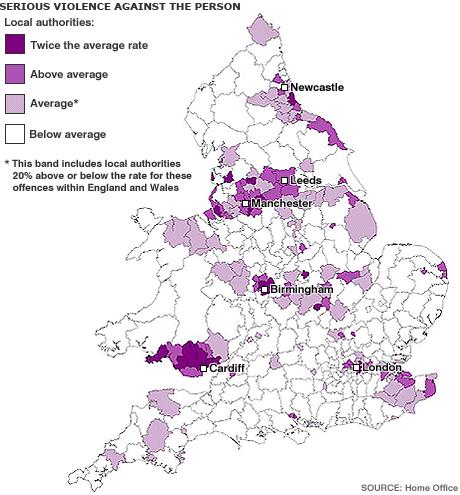
6 The importance of crime mapping for policing in Scotland Scotland s unenviable reputation of being murder capital of Europe (WHO 2005) Majority of Scottish cities have below average crime rates; the exception being Glasgow. Majority of areas within Glasgow have below average crime rates; police hot spot maps have been used to identify the problem areas. Understanding the geographical, social and physical context of specific parts of Glasgow has had a major impact in tackling violence and reducing crime rates. Crime reduction has been facilitated by implementing policy and practice based on evidence linking police crime data to a range of other data sources.
7 Quality and availability of geo-coded data From a criminologists perspective, the quality and availability of geocoded data in Scotland (and other parts of Europe) is poor. Nationally available data for research is patchy and often available at macro levels of analysis (e.g. Homicide at Local Authority Level only). Data are not updated on a regular basis, which makes trend analysis impossible. Access to police data is difficult to negotiate and many restrictions are placed on users (trust between academics and practitioners is critical).
8 A Scottish case study of vandalism (Ellie Bates, PhD Student) Overall trends in vandalism in an Edinburgh suburb
 Class 3 - High (Estimate) Class 1 - Medium (3 to 5) 27.1% (S) Class 1 - Medium (E) Class 2 - Low (1 to 2) 38.7% (S) Class 2 - Low (E) Class 4 - Very Low (0 to 1) 25.")
9 Mean of Counts of Vandalisms per Output Area in group Trajectory patterns of vandalism at Output Area level Class 3 - High 9.0% (Sample) Class 3 - High (Estimate) Class 1 - Medium (3 to 5) 27.1% (S) Class 1 - Medium (E) Class 2 - Low (1 to 2) 38.7% (S) Class 2 - Low (E) Class 4 - Very Low (0 to 1) 25.1% (S) Class 4 - Very Low (E) Years

10 Trajectory patterns of vandalism at 100m Grid level
11 What predicts vandalism at these 2 levels? At the 100m grid level: High residential density High concentration of business addresses In vicinity of local school Lack of recreational facilities At the Output Area level: High welfare dependency
12 Adding the voice of the police A similar dichotomy of micro and macro level explanations Specific examples of how the public interact with space Complex understanding of the context of specific areas Areas of high, low and drifting crime
13 Implications for policy & practice The police (and other agencies!) need to improve data quality and availability AND researchers need to include practitioners as key stakeholders from the start and demonstrate in practical terms how research. Crime prevention strategies require both geographical knowledge AND understanding of the social and physical use of space. Processes that impact on crime may operate at different levels AND not all of these processes are the responsibility of the police. Statistical and mapping tools are important to see the big picture BUT effective interventions require good local knowledge from those on the ground.
Analysing The Temporal Pattern Of Crime Hotspots In South Yorkshire, United Kingdom
 Advances in Social Sciences Research Journal Vol.5, No.6 Publication Date: June. 25, 218 DoI:1.14738/assrj.56.4822. Abdullahi, H., & Abbas, I. I. (218). Analysing The Temporal Pattern Of Crime Hotspots
CPTED in Latin America
 CPTED in Latin America Measurement & Evaluation A piloted model Ma. Macarena Rau Dr. Tim Pascoe Partnership Our Credentials: International CPTED Association CPTED Corporación Region LAC UK Institute of
- Geography is important when studying crime because when a crime happens it always has a location, a time and a reason.
 - Geography is important when studying crime because when a crime happens it always has a location, a time and a reason. - Crime figures are collected from the number of crime incidents reported to the
Examining the extent to which hotspot analysis can support spatial predictions of crime
 Examining the extent to which hotspot analysis can support spatial predictions of crime Spencer Paul Chainey Thesis submitted in accordance with the requirements of the Degree of Doctor of Philosophy University
Protocol between London MAPPA Strategic Management Board (SMB) and (Name of Borough) Local Safeguarding Children Board
 and (Name of Borough) Local Safeguarding Children Board") LONDON MULTI-AGENCY PUBLIC PROTECTION ARRANGEMENTS (MAPPA) Protocol between London MAPPA Strategic Management Board (SMB) and (Name of Borough) Local Safeguarding Children Board This protocol has been
LONDON MULTI-AGENCY PUBLIC PROTECTION ARRANGEMENTS (MAPPA) Protocol between London MAPPA Strategic Management Board (SMB) and (Name of Borough) Local Safeguarding Children Board This protocol has been
What Explains the Effectiveness of Hot Spots Policing And What New Strategies Should we Employ?
 What Explains the Effectiveness of Hot Spots Policing And What New Strategies Should we Employ? David Weisburd Executive Director Center for Evidence-Based Crime Policy George Mason 1 The Effectiveness
GeoHealth Applications Platform ESRI Health GIS Conference 2013
 GeoHealth Applications Platform ESRI Health GIS Conference 2013 Authors Thomas A. Horan, Ph.D. Professor, CISAT Director April Moreno Health GeoInformatics Ph.D. Student Brian N. Hilton, Ph.D. Clinical
Geographic/Demographic Accessibility of Transport Infrastructure (GDATI)
") Geographic/Demographic Accessibility of Transport Infrastructure (GDATI) Lidia Zakowska, Wieslaw Starowicz, Sabina Pulawska To cite this report: Lidia Zakowska, Wieslaw Starowicz and Sabina Pulawska (2012)
Geographic/Demographic Accessibility of Transport Infrastructure (GDATI) Lidia Zakowska, Wieslaw Starowicz, Sabina Pulawska To cite this report: Lidia Zakowska, Wieslaw Starowicz and Sabina Pulawska (2012)
Presented at ESRI Education User Conference, July 6-8, 2001, San Diego, CA
 Presented at ESRI Education User Conference, July 6-8, 2001, San Diego, CA Irina V. Sharkova, Ph.D., Research Assistant Professor Richard Lycan, Ph.D., Senior Research Associate Population Research Center
A Micro-Spatial Analysis of Violent Crime
 A Micro-Spatial Analysis of Violent Crime The Experience of a Small Southern City Isaac T. Van Patten Radford University Levels of Measurement Macro-spatial analysis Crime at the state, regional, or national
Colin Bray, OSi CEO. Collaboration to develop a data platform for geospatial and statistical information in Ireland
 Colin Bray, OSi CEO Collaboration to develop a data platform for geospatial and statistical information in Ireland Organisations Ireland s National Mapping Agency Established in 1824 Operates under the
Dr Spencer Department of Security and Crime Science, University College London
 The Crime Prediction Framework: a spatial temporal framework for targeting patrols, crime prevention and strategic policy National Security Summit, San Diego 18 July 2015 Dr Spencer Chainey @SpencerChainey
Profiling Burglary in London using Geodemographics
 Profiling Burglary in London using Geodemographics C G Gale *1, A D Singleton 2 and P A Longley 3 1 UCL Department of Civil, Environmental & Geomatic Engineering 2 University of Liverpool Department of
GIS AND COMMUNITY ENGAGEMENT: SOCIOSPATIAL APPROACHES TO RESEARCH AND POLICY
 GIS AND COMMUNITY ENGAGEMENT: SOCIOSPATIAL APPROACHES TO RESEARCH AND POLICY DR. SHEILA LAKSHMI STEINBERG BRANDMAN UNIVERSITY CHAPMAN UNIVERSITY SYSTEM GIS DAY PRESENTATION-UNIVERSITY OF KANSAS, NOVEMBER
BIG IDEAS. Area of Learning: SOCIAL STUDIES Urban Studies Grade 12. Learning Standards. Curricular Competencies
 Area of Learning: SOCIAL STUDIES Urban Studies Grade 12 BIG IDEAS Urbanization is a critical force that shapes both human life and the planet. The historical development of cities has been shaped by geographic,
A new metric of crime hotspots for Operational Policing
 A new metric of crime hotspots for Operational Policing Monsuru Adepeju *1, Tao Cheng 1, John Shawe-Taylor 2, Kate Bowers 3 1 SpaceTimeLab for Big Data Analytics, Department of Civil, Environmental and
An online data and consulting resource of THE UNIVERSITY OF TOLEDO THE JACK FORD URBAN AFFAIRS CENTER
 An online data and consulting resource of THE JACK FORD URBAN AFFAIRS CENTER THE CENTER FOR GEOGRAPHIC INFORMATION SCIENCE AND APPLIED GEOGRAPHICS DEPARTMENT OF GEOGRAPHY AND PLANNING THE UNIVERSITY OF
Exploring the Impact of Ambient Population Measures on Crime Hotspots
 Exploring the Impact of Ambient Population Measures on Crime Hotspots Nick Malleson School of Geography, University of Leeds http://nickmalleson.co.uk/ N.S.Malleson@leeds.ac.uk Martin Andresen Institute
Landmarks Paula Owens 5 7 years
 Landmarks Paula Owens Geography teaching resource 5 7 years This is one of a series of teaching resources for use with Digimap for Schools. For more details about this service, visit http://digimapforschools.edina.ac.uk
Department Of Geography. MSc Applied GIS.
 Department Of Geography. MSc Applied GIS. This is a really exciting time to be in GIS, with new tools and new software allowing the application of GIS techniques to an ever-increasing range of fields.
Accessibility as an Instrument in Planning Practice. Derek Halden DHC 2 Dean Path, Edinburgh EH4 3BA
 Accessibility as an Instrument in Planning Practice Derek Halden DHC 2 Dean Path, Edinburgh EH4 3BA derek.halden@dhc1.co.uk www.dhc1.co.uk Theory to practice a starting point Shared goals for access to
Smart City Governance for effective urban governance. David Ludlow Assoc. Professor European Smart Cities University of the West of England, Bristol
 Smart City Governance for effective urban governance David Ludlow Assoc. Professor European Smart Cities University of the West of England, Bristol Complexities of urban territorial governance Complexities
VIDEO: The World In A Box: Geographic Information Systems
 Geographic Information Systems VIDEO: The World In A Box: Geographic Information Systems Adapted from: The World In A Box: Geographic Information Systems. A Public Television Documentary, Opticus Corporation:
Application Issues in GIS: the UCL Centre for Advanced Spatial Analysis. Paul Longley UCL
 Application Issues in GIS: the UCL Centre for Advanced Spatial Analysis Paul Longley UCL GIS: inclusive, shared understanding Geodemographics as a focus of interest Profiling public goods and services
GIS for Crime Analysis. Building Better Analysis Capabilities with the ArcGIS Platform
 GIS for Crime Analysis Building Better Analysis Capabilities with the ArcGIS Platform Crime Analysis The Current State One of the foundations of criminological theory is that three things are needed for
GOVERNMENT MAPPING WORKSHOP RECOVER Edmonton s Urban Wellness Plan Mapping Workshop December 4, 2017
 GOVERNMENT MAPPING WORKSHOP 12.4.17 RECOVER Edmonton s Urban Wellness Plan Mapping Workshop December 4, 2017 In July of 2017, City Council directed administration to develop RECOVER, Edmonton s Urban Wellness
A 3D GEOVISUALIZATION APPROACH TO CRIME MAPPING
 A 3D GEOVISUALIZATION APPROACH TO CRIME MAPPING Markus Wolff, Hartmut Asche 3D-Geoinformation Research Group Department of geography University of Potsdam Markus.Wolff@uni-potsdam.de, gislab@uni-potsdam.de
Seasonality in recorded crime: preliminary findings
 Seasonality in recorded crime: preliminary findings Celia Hird Chandni Ruparel Home Office Online Report /7 The views expressed in this report are those of the authors, not necessarily those of the Home
Report on the establishment of UN GGIM: Europe Item 14. 4th session of the Committee of Experts on UN-GGIM
 Report on the establishment of UN GGIM: Europe Item 14 1 Why regional European committees of UN GGIM? In the ECOSOC resolution 2011/24 on the UN GGIM: Emphasizes the importance of promoting national, regional
Bengt Kjellson Chair of the Executive Committee UN-GGIM: Europe. 2 nd Joint UN-GGIM: Europe ESS Meeting 11 th March 2016, Luxembourg
 Bengt Kjellson Chair of the Executive Committee UN-GGIM: Europe 2 nd Joint UN-GGIM: Europe ESS Meeting 11 th March 2016, Luxembourg A global geospatial mandate At its 47th plenary in July 2011, ECOSOC,
Assessment and management of at risk populations using a novel GIS based UK population database tool
 Safety and Security Engineering 203 Assessment and management of at risk populations using a novel GIS based UK population database tool H. Balmforth 1, H. McManus 1 & A. Fowler 2 1 Health and Safety Laboratory,
Spatial Planning & Climate Change
 Spatial Planning & Climate Change A GRIP Approach Joseph Scott, Glasgow & Clyde Valley Strategic Development Plan Authority, Scotland Today s presentation Context Spatial Planning & Climate Change Exploring
Space and the City: Modern Chicago (and Beyond)
") Space and the City: Modern Chicago (and Beyond) Robert J. Sampson Department of Sociology Harvard University Concentration of Collective Action Events in Chicago Spatial Interdependence of Concentrated
Space and the City: Modern Chicago (and Beyond) Robert J. Sampson Department of Sociology Harvard University Concentration of Collective Action Events in Chicago Spatial Interdependence of Concentrated
Spatial Planning and Territorial Development at the Regional Level
 Spatial Planning and Territorial Development at the Regional Level Vincent Nadin University of the West of England, UK Spatial Planning and Territorial Development at the Regional Level Vincent Nadin University
Spatial Statistical Analysis of burglary Crime in Chennai City Promoters Apartments: A CASE STUDY
 Spatial Statistical Analysis of burglary Crime in Chennai City Promoters Apartments: A CASE STUDY M.Vijaya Kumar Assistant Professor K.S.R.College of Engineering Tiruchengode Dr.C.Chandrasekar Associate
The City in Urban Poverty. Charlotte Lemanski and Colin Marx (eds.)
") The City in Urban Poverty. Charlotte Lemanski and Colin Marx (eds.). 2015. Basingstoke and New York: Palgrave Macmillan. 239 pages. Hardback: 65.00, ISBN: 978-1-137-36742-6. This is an important book with
The City in Urban Poverty. Charlotte Lemanski and Colin Marx (eds.). 2015. Basingstoke and New York: Palgrave Macmillan. 239 pages. Hardback: 65.00, ISBN: 978-1-137-36742-6. This is an important book with
Territorial evidence for a European Urban Agenda TOWN in Europe
 Territorial evidence for a European Urban Agenda TOWN in Europe Loris Servillo Brussels, 25 November 2014 Outline 1. SMSTs in the EU territory 2. General vs specific trends? 3. Evidences for more appropriated
GIS Spatial Statistics for Public Opinion Survey Response Rates
 GIS Spatial Statistics for Public Opinion Survey Response Rates July 22, 2015 Timothy Michalowski Senior Statistical GIS Analyst Abt SRBI - New York, NY t.michalowski@srbi.com www.srbi.com Introduction
Manchester City Region: The case for agglomeration economies. Steve Gibbons Henry Overman Alessandra Tucci
 Manchester City Region: The case for agglomeration economies Steve Gibbons Henry Overman Alessandra Tucci Objectives Explain agglomeration economies Review of existing evidence Primary evidence on role
Transport Planning in Large Scale Housing Developments. David Knight
 Transport Planning in Large Scale Housing Developments David Knight Large Scale Housing Developments No longer creating great urban spaces in the UK (Hall 2014) Transport Planning Transport planning processes
Whitehand, J.W.R. (1966) The selection of research students, Universities Quarterly 21, 44 7.
 The selection of research students, Universities Quarterly 21, 44 7.") Professor Jeremy Whitehand Selected Publications Whitehand, J.W.R. (1966) The selection of research students, Universities Quarterly 21, 44 7. Whitehand, J.W.R. (1967) 'Fringe belts: a neglected aspect
Professor Jeremy Whitehand Selected Publications Whitehand, J.W.R. (1966) The selection of research students, Universities Quarterly 21, 44 7. Whitehand, J.W.R. (1967) 'Fringe belts: a neglected aspect
Data Matrix User Guide
 Data Matrix User Guide 1. Introduction The 2017 Data Matrix is designed to support the 2017 iteration of the Regional Skills Assessments (RSAs) in Scotland. The RSAs align with the Regional Outcome Agreement
Letting reality speak. How the Chicago School Sociology teaches scholars to speak with our findings.
 Letting reality speak. How the Chicago School Sociology teaches scholars to speak with our findings. By Nanke Verloo n.verloo@uva.nl Assistant professor in Urban Planning, University of Amsterdam. Think
Hotspots A Methodology For Identifying, Prioritising And Tackling Litter In Urban Environments
 Hotspots A Methodology For Identifying, Prioritising And Tackling Litter In Urban Environments R Catchlove 1 and M Francey 2 1 Melbourne Water, robert.catchlove@melbournewater.com.au 2 Melbourne Water,
WHITE PAPER ON QUANTUM COMPUTING AND QUANTUM COMMUNICATION
 WHITE PAPER ON QUANTUM COMPUTING AND QUANTUM COMMUNICATION Based on the discussion during the respective workshop at the ZEISS Symposium Optics in the Quantum World on 18 April 2018 in Oberkochen, Germany
Exploring Digital Welfare data using GeoTools and Grids
 Exploring Digital Welfare data using GeoTools and Grids Hodkinson, S.N., Turner, A.G.D. School of Geography, University of Leeds June 20, 2014 Summary As part of the Digital Welfare project [1] a Java
Tackling urban sprawl: towards a compact model of cities? David Ludlow University of the West of England (UWE) 19 June 2014
 19 June 2014") Tackling urban sprawl: towards a compact model of cities? David Ludlow University of the West of England (UWE) 19 June 2014 Impacts on Natural & Protected Areas why sprawl matters? Sprawl creates environmental,
Tackling urban sprawl: towards a compact model of cities? David Ludlow University of the West of England (UWE) 19 June 2014 Impacts on Natural & Protected Areas why sprawl matters? Sprawl creates environmental,
Title: Attracting and retaining knowledge workers: the strengths and weaknesses of Northern-European cities
 Title: Attracting and retaining knowledge workers: the strengths and weaknesses of Northern-European cities Bart Sleutjes, University of Amsterdam General theme: S Regional economic modeling --------------------------------------------------------------------------------------------------------------------------------------
POLICE SCOTLAND PROFESSIONAL STANDARDS DEPARTMENT NATIONAL STATISTICAL PERFORMANCE REPORT
 NOT PROTECTIVELY MARKED SIONAL STANDARD POLICE SCOTLAND PROFESSIONAL STANDARDS DEPARTMENT NATIONAL STATISTICAL PERFORMANCE REPORT Covering the period: April 2016 March 2017 NOT PROTECTIVELY MARKED Total
Challenges in Geocoding Socially-Generated Data
 Challenges in Geocoding Socially-Generated Data Jonny Huck (2 nd year part-time PhD student) Duncan Whyatt Paul Coulton Lancaster Environment Centre School of Computing and Communications Royal Wedding
Archaeology & Digital Humanities
 WAYNE STATE UNIVERSITY Archaeology & Digital Humanities The D.I.R.T. on Big Data STRENGTHENING THE BIG DATA & ANALYTICS ECOSYSTEM WAYNE STATE UNIVERSITY Krysta Ryzewski Associate Professor of Anthropology
THE UNIVERSITY OF HONG KONG FACULTY OF SOCIAL SCIENCES
 THE UNVERSTY OF HONG KONG FACULTY OF SOCAL SCENCES Courses offered to Exchange/Visiting Students in the 2013-2014 Academic Year For course details, please refer to the Departmental Link Department of Geography
Implementing the Sustainable Development Goals: The Role of Geospatial Technology and Innovation
 Fifth High Level Forum on UN Global Geospatial Information Management Implementing the Sustainable Development Goals: The Role of Geospatial Technology and Innovation 28-30 November 2017 Sheraton Maria
Understanding China Census Data with GIS By Shuming Bao and Susan Haynie China Data Center, University of Michigan
 Understanding China Census Data with GIS By Shuming Bao and Susan Haynie China Data Center, University of Michigan The Census data for China provides comprehensive demographic and business information
National Spatial Development Perspective (NSDP) Policy Coordination and Advisory Service
 Policy Coordination and Advisory Service") National Spatial Development Perspective (NSDP) Policy Coordination and Advisory Service 1 BACKGROUND The advances made in the First Decade by far supersede the weaknesses. Yet, if all indicators were
National Spatial Development Perspective (NSDP) Policy Coordination and Advisory Service 1 BACKGROUND The advances made in the First Decade by far supersede the weaknesses. Yet, if all indicators were
Understanding the spatial pattern of urban crime: a developing country s perspective
 Understanding the spatial pattern of urban crime: a developing country s perspective Faisal Umar *1, James Cheshire 1 and Shane Johnson 2 1 UCL Department of Geography, Pearson Building, Gower Street,
ENV208/ENV508 Applied GIS. Week 1: What is GIS?
 ENV208/ENV508 Applied GIS Week 1: What is GIS? 1 WHAT IS GIS? A GIS integrates hardware, software, and data for capturing, managing, analyzing, and displaying all forms of geographically referenced information.
The Governance of Land Use
 The planning system The Governance of Land Use United Kingdom Levels of government and their responsibilities The United Kingdom is a unitary state with three devolved governments in Northern Ireland,
Economic and Social Council
 United Nations Economic and Social Council Distr.: General 18 July 2016 Original: English Committee of Experts on Global Geospatial Information Management Sixth session New York, 3-5 August 2016 Item 2
Transport, Travel and Trade. Geography teaching resource years. Paula Owens.
 http://digimapforschools.edina.ac.uk Transport, Travel and Trade Paula Owens Geography teaching resource 7-11 years This is one of a series of teaching resources for use with Digimap for Schools. For more
The spatial network Streets and public spaces are the where people move, interact and transact
 The spatial network Streets and public spaces are the where people move, interact and transact The spatial network Cities are big spatial networks that create more of these opportunities Five key discoveries
Creating A-16 Compliant National Data Theme for Cultural Resources
 Creating A-16 Compliant National Data Theme for Cultural Resources Cultural Resource GIS Facility National Park Service John J. Knoerl Deidre McCarthy Paper 169 Abstract OMB Circular A-16 defines a set
A new type of RICEPOTS
 A new type of RICEPOTS Alan Parkinson Geography teaching resource College Crown Copyright and Database Right 2014. Ordnance Survey (Digimap Licence) This is one of a series of teaching resources for use
Comparison of spatial methods for measuring road accident hotspots : a case study of London
 Journal of Maps ISSN: (Print) 1744-5647 (Online) Journal homepage: http://www.tandfonline.com/loi/tjom20 Comparison of spatial methods for measuring road accident hotspots : a case study of London Tessa
Shaping Your Neighbourhood
 Shaping Your Neighbourhood Building a Core Sustainable Neighbourhood Action Plan Nov. 25 & 26, 2006 Welcome! Peter Russell Planner, Holland Barrs Planning Group Inc. Role in this project: Work with the
Monsuru Adepeju 1 and Andy Evans 2. School of Geography, University of Leeds, LS21 1HB 1
 Investigating the impacts of training data set length (T) and the aggregation unit size (M) on the accuracy of the self-exciting point process (SEPP) hotspot method Monsuru Adepeju 1 and Andy Evans 2 1,
Introducing the WISERD Geoportal. WISERD DATA TEAM Dr Robert Berry & Dr Richard Fry, University of Glamorgan Dr Scott Orford, Cardiff University
 Introducing the WISERD Geoportal WISERD DATA TEAM Dr Robert Berry & Dr Richard Fry, University of Glamorgan Dr Scott Orford, Cardiff University WISERD What is WISERD? Wales Institute of Social and Economic
APPLIED FIELDWORK ENQUIRY SAMPLE ASSESSMENT MATERIALS
 GCSE GEOGRAPHY B Sample Assessment Materials 85 GCSE GEOGRAPHY B COMPONENT 3 APPLIED FIELDWORK ENQUIRY SAMPLE ASSESSMENT MATERIALS 1 hour 30 minutes For examiner s use only SPaG Part A 18 0 Part B 18 0
Vincent Goodstadt. Head of European Affairs METREX European Network
 Vincent Goodstadt Head of European Affairs METREX European Network METREX (Network of 50 European Metropolitan Regions and Areas ) Exchanging Knowledge (e.g. Benchmarking) Climate Change CO2/80/50 Expertise
Maanmittauspäivät 2018 Helsinki Maanmittauspäivät 2018 The Danish initiatives regarding open and free basic data including effect studies
 Maanmittauspäivät 2018 The Danish initiatives regarding open and free basic data including effect studies 22.03.2018 Agenda 1. Intro overall frame / selfie 2. Data Infrastructure 3. The Danish Digital
Education for Tourism Development
 Abstract: Education for Tourism Development David Airey 1 University of Surrey, UK Successful tourist development depends in part upon appropriate education provision. At the same time, the needs of tourist
INTELLIGENT CITIES AND A NEW ECONOMIC STORY CASES FOR HOUSING DUNCAN MACLENNAN UNIVERSITIES OF GLASGOW AND ST ANDREWS
 INTELLIGENT CITIES AND A NEW ECONOMIC STORY CASES FOR HOUSING DUNCAN MACLENNAN UNIVERSITIES OF GLASGOW AND ST ANDREWS THREE POLICY PARADOXES 16-11-08 1. GROWING FISCAL IMBALANCE 1. All orders of government
Riocan Centre Study Area Frontenac Mall Study Area Kingston Centre Study Area
 OVERVIEW the biggest challenge of the next century (Dunham Jones, 2011). New books are continually adding methods and case studies to a growing body of literature focused on tackling this massive task.
Historical background
 Space Technology for Disaster Management in Sri Lanka: Country profile, national perspectives & vision. Professor Ranjith Premalal De Silva Vice Chancellor Uva Wellassa University of Sri Lanka October
GREEN INFRASTRUCTURE, PARTICIPATORY MODELING, & DELIBERATIVE DEMOCRACY
 GREEN INFRASTRUCTURE, PARTICIPATORY MODELING, & DELIBERATIVE DEMOCRACY Katharine Travaline, Alex Waldman, & Franco Montalto, PhD September 27, 2011 Philadelphia Low Impact Development Symposium Introduction
The Global Statistical Geospatial Framework and the Global Fundamental Geospatial Themes
 The Global Statistical Geospatial Framework and the Global Fundamental Geospatial Themes Sub-regional workshop on integration of administrative data, big data and geospatial information for the compilation
Integrating Official Statistics and Geospatial Information NBS Experience
 Integrating Official Statistics and Geospatial Information NBS Experience Presented by Eng. Reda AL Sabbagh Director of IT Dept. Prepared by Eng. Adham Makky GIS Specialist Topics to be covered: Background
Content Area: Social Studies Standard: 1. History Prepared Graduates: Develop an understanding of how people view, construct, and interpret history
 Standard: 1. History Develop an understanding of how people view, construct, and interpret history 1. Organize and sequence events to understand the concepts of chronology and cause and effect in the history
violent offenses, social interaction theory, ambient temperature, geographic
 Global Journal of Science Frontier Research: H Environment & Earth Science Volume 14 Issue 6 Version 1.0 Year 2014 Type : Double Blind Peer Reviewed International Research Journal Publisher: Global Journals
Crime Analysis. GIS Solutions for Intelligence-Led Policing
 Crime Analysis GIS Solutions for Intelligence-Led Policing Applying GIS Technology to Crime Analysis Know Your Community Analyze Your Crime Use Your Advantage GIS aids crime analysis by Identifying and
GREAT BRITAIN: INDUSTRIAL REVOLUTION TO 1851 Student Worksheet
 GREAT BRITAIN: INDUSTRIAL REVOLUTION TO 1851 Student Worksheet Theme of Map This thematic map captures the industrial development of Britain at a time when it had transformed the British economy and society.
Kenneth Melchert (Senior Statistician - Regional Liaison Officer)
") Sourcing Spatial Data from Local Government Getting the Data Right The Supplier s Perspective Presenter: Kenneth Melchert (Senior Statistician - Regional Liaison Officer) Information Products and Services
Sourcing Spatial Data from Local Government Getting the Data Right The Supplier s Perspective Presenter: Kenneth Melchert (Senior Statistician - Regional Liaison Officer) Information Products and Services
Geographic Information Systems A GIS Primer for Public Health. Capacity Building Workshop October 19, 2009
 Geographic Information Systems A for Public Health Capacity Building Workshop October 19, 2009 Agenda Welcome (:10) OAHPP GIS Workshop Series (:10) GIS: A Four Letter Word (:10) The Fundamentals (:30)
John Laznik 273 Delaplane Ave Newark, DE (302)
") Office Address: John Laznik 273 Delaplane Ave Newark, DE 19711 (302) 831-0479 Center for Applied Demography and Survey Research College of Human Services, Education and Public Policy University of Delaware
Office Address: John Laznik 273 Delaplane Ave Newark, DE 19711 (302) 831-0479 Center for Applied Demography and Survey Research College of Human Services, Education and Public Policy University of Delaware
Egypt Public DSS. the right of access to information. Mohamed Ramadan, Ph.D. [R&D Advisor to the president of CAPMAS]
![Egypt Public DSS. the right of access to information. Mohamed Ramadan, Ph.D. [R&D Advisor to the president of CAPMAS]](/thumbs/89/98483713.jpg "Egypt Public DSS. the right of access to information. Mohamed Ramadan, Ph.D. [R&D Advisor to the president of CAPMAS]") Egypt Public DSS ì the right of access to information Central Agency for Public Mobilization and Statistics Arab Republic of Egypt Mohamed Ramadan, Ph.D. [R&D Advisor to the president of CAPMAS] Egypt
Egypt Public DSS ì the right of access to information Central Agency for Public Mobilization and Statistics Arab Republic of Egypt Mohamed Ramadan, Ph.D. [R&D Advisor to the president of CAPMAS] Egypt
COUNTY SPATIAL DATA INFRASTRUCTURE PRESENTATION: BY: GEOFREY CHERUIYOT NAIROBI CITY COUNTY
 . COUNTY SPATIAL DATA INFRASTRUCTURE PRESENTATION: BY: GEOFREY CHERUIYOT NAIROBI CITY COUNTY FRAMEWORK FOR AN INTEGRATED SPATIAL DATA INFRASTRUCTURE County GIS GIS : A computer based information system
The Role of Urban Planning and Local SDI Development in a Spatially Enabled Government. Faisal Qureishi
 The Role of Urban Planning and Local SDI Development in a Spatially Enabled Government Faisal Qureishi 1 Introduction A continuous increase in world population combined with limited resources has lead
ESPON evidence on European cities and metropolitan areas
 BEST METROPOLISES Final Conference 18 April 2013, Warsaw ESPON evidence on European cities and metropolitan areas Michaela Gensheimer Structure of Intervention Content Part I: What is the ESPON 2013 Programme?
Big-Geo-Data EHR Infrastructure Development for On-Demand Analytics
 Big-Geo-Data EHR Infrastructure Development for On-Demand Analytics Sohayla Pruitt, MA Senior Geospatial Scientist Duke Medicine DUHS DHTS EIM HIRS Page 1 Institute of Medicine, World Health Organization,
Social Studies Grade 2 - Building a Society
 Social Studies Grade 2 - Building a Society Description The second grade curriculum provides students with a broad view of the political units around them, specifically their town, state, and country.
Territorial Cooperation within the Northern Periphery and the Arctic
 Territorial Cooperation within the Northern Periphery and the Arctic 12 March 2013 / By Silvia Curbelo Betancort North charr project, Landösjön lake, Sweden. Source: North Periphery Programme Today we
Report on the impact of open geographical data - Danish effect studies -
 Presented at the FIG Congress 2018, May 6-11, 2018 in Istanbul, Turkey Report on the impact of open geographical data - Danish effect studies - (Paper no 9603) Agenda 1. Intro teaser 2. Basic digital infrastructure
Oman NSDI Supporting Economic Development. Saud Al-Nofli Director of Spatial Data Directorate General of NSDI, NCSI
 Oman NSDI Supporting Economic Development 2017 Saud Al-Nofli Director of Spatial Data Directorate General of NSDI, NCSI "It s critical to make correct decisions the first time to optimize the Investments
Economic and Social Council
 United Nations Economic and Social Council Distr.: General 23 May 2012 Original: English E/CONF.101/100 Tenth United Nations Conference on the Standardization of Geographical Names New York, 31 July 9
Dr.Sinisa Vukicevic Dr. Robert Summers
 Dr.Sinisa Vukicevic Dr. Robert Summers "Planning" means the scientific, aesthetic, and orderly disposition of land, resources, facilities and services with a view to securing the physical, economic and
Food Mapping for Community Food Activity. A Briefing Paper from the Scottish Community Diet Project Round Table Discussion.
 Food Mapping for Community Food Activity A Briefing Paper from the Scottish Community Diet Project Round Table Discussion 27 May 2004 Food mapping has been defined as the process of finding out where people
The CrimeStat Program: Characteristics, Use, and Audience
 The CrimeStat Program: Characteristics, Use, and Audience Ned Levine, PhD Ned Levine & Associates and Houston-Galveston Area Council Houston, TX In the paper and presentation, I will discuss the CrimeStat
City of Jerez Urban Core Densification proposal; An Agent Based Spatio-temporal model
 Modelling urban population allocation City of Jerez Urban Core Densification proposal; An Agent Based Spatio-temporal model Elke Sauter Julia Úbeda Who we are & why we are here Masters programme: Geographical
Overcoming Social Inequities with Technology, Today. Christopher Thomas, Director of Government Markets
 Overcoming Social Inequities with Technology, Today Christopher Thomas, Director of Government Markets A Move Towards Smart Communities Sustainable Every community can be Livable Transparent Resilient
Millennium Cohort Study:
 Millennium Cohort Study: Geographic Identifiers in MCS June 2009 Jon Johnson Centre for Longitudinal Studies Faculty of Policy and Society Institute of Education, University of London Page 1 Introduction