GIS AND COMMUNITY ENGAGEMENT: SOCIOSPATIAL APPROACHES TO RESEARCH AND POLICY
|
|
|
- Gavin Weaver
- 5 years ago
- Views:
Transcription

1 GIS AND COMMUNITY ENGAGEMENT: SOCIOSPATIAL APPROACHES TO RESEARCH AND POLICY DR. SHEILA LAKSHMI STEINBERG BRANDMAN UNIVERSITY CHAPMAN UNIVERSITY SYSTEM GIS DAY PRESENTATION-UNIVERSITY OF KANSAS, NOVEMBER 15, 2017
2 WHAT IS GIS? Geographic Information Systems A GIS is designed to store, manipulate, analyze, and output map-based information (Steinberg & Steinberg 2015: 5). A methodological data collection, analysis and communication tool Computerized mapping
3 GIS ENABLES INTERDISCIPLINARY THINKING Ability to integrate different disciplines and approaches together. Useful for solving problems. Enables the consideration of qualitative data in a powerful geographic format.

4 IMAGES OF GIS IN ACTION
5 TWO IMPORTANT CONCEPTS: SPACE AND PLACE Space is the distance between places. Place is a meaningful location (Cresswell 2004). * A location that has some importance and this can vary by individuals, groups and societies that inhabit a place.

6 THINKING SPATIALLY ABOUT PLACE
7 SOCIOSPATIAL An integrated examination of space, place and social indicators in a holistic fashion (Steinberg and Steinberg 2009; 2015). A main methodological aspect of sociospatial thinking is QUALITATIVE RESEARCH METHODS.


8 HISTORIC EXAMPLE OF SOCIOSPATIAL THINKING (1895) FLORENCE KELLY HULL HOUSE, CHICAGO, ILLINOIS
9 EXAMPLES OF HISTORICAL PROBLEMS SOLVED USING SOCIOSPATIAL THINKING-FLORENCE KELLY HULL HOUSE, CHICAGO, IL U.S.A. Among the Hull House Settlement research projects were a series of detailed studies of neighborhoods. These settlements were home to many recent immigrants to Chicago. The majority of these individuals emigrated from central, southern, and eastern Europe. Map on previous slide originally appeared in Hull-House Maps and Papers and shows the nationalities of residents of the neighborhoods bordered by Polk, Twelfth, Halsted, and Jefferson Streets. Hull House Map (Nationalities), 1895, Northwestern University.
10 SOCIOSPATIAL APPROACH FOR QUALITATIVE METHODOLOGIES Ethnography Case studies Oral history Participant observation Evaluation research Interviews

11 SIMPLE SOCIOSPATIAL THINKING
12 GROUNDED THEORY Glaser and Strauss (1967) Inductive research approach Characterized by the sequencing of data collection followed by theory generation Strong connection to the reality that the data represent
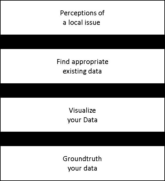
13 STEPS FOR SOCIOSPATIAL GROUNDED THEORY: 1) Determine a topic of interest. 2) Determine a geographic location of interest. 3) Collect the data (qualitative, spatially linked and social data). 4) Geocode the data. 5) Ground truth the data. 6) Analyze the data and look for spatial and social patterns. 7) Generate theory (spatial and social).

14 14
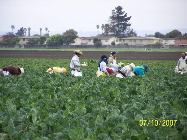
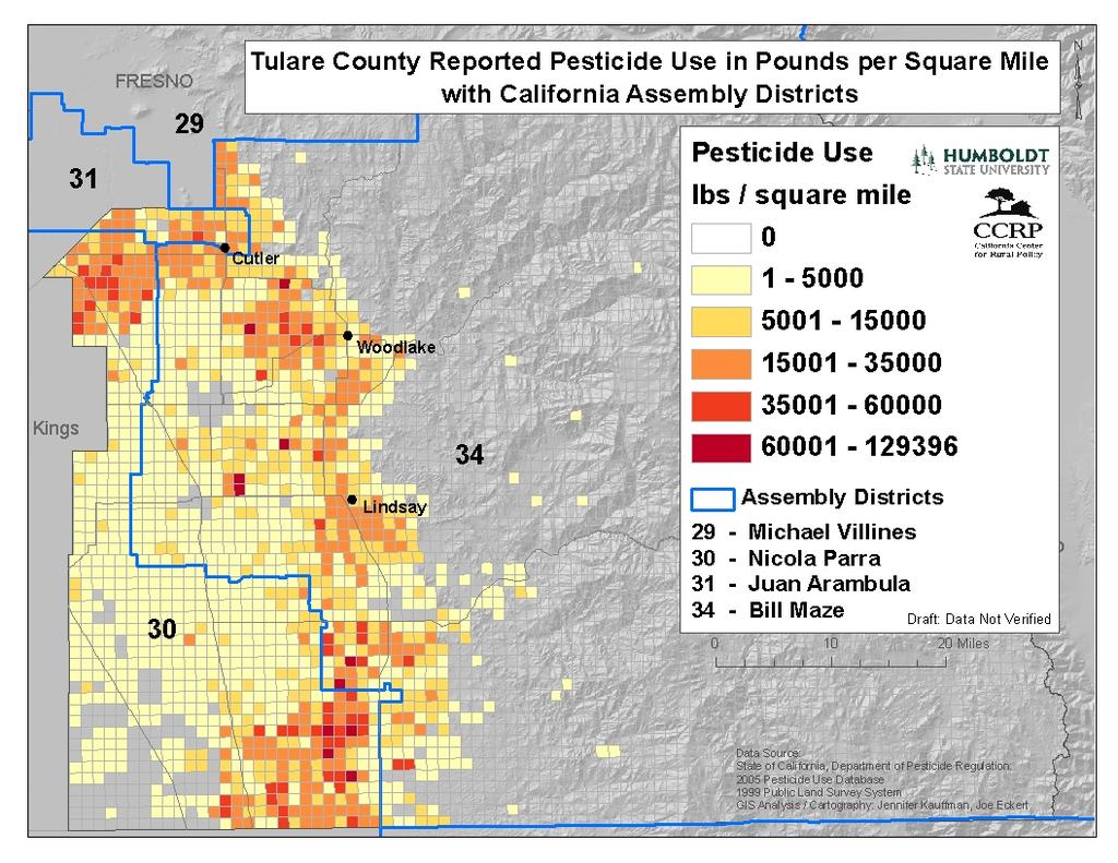
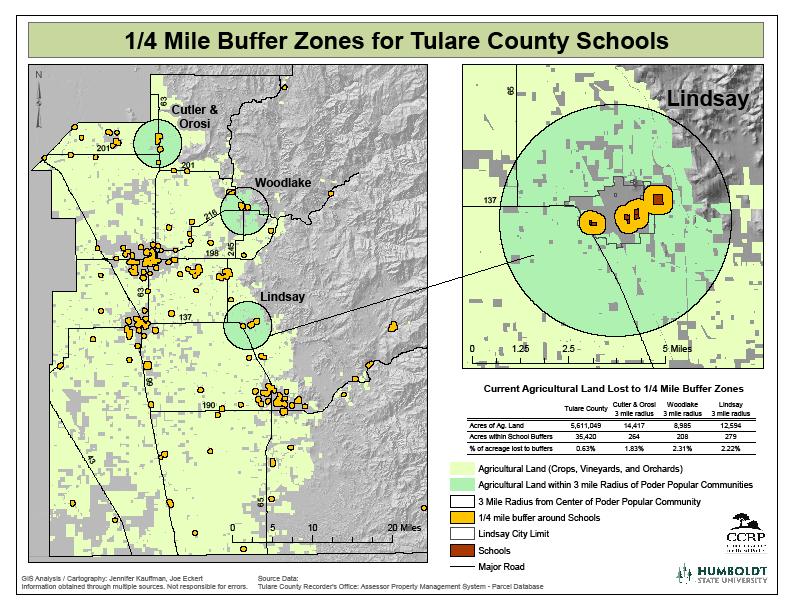
15 1) DETERMINE TOPIC OF INTEREST What is the risk of pesticide exposure to school kids in agricultural communities? Where are pesticides of concern located? Who is being affected by these pesticides? What organizations are involved with Poder Popular s work on pesticide health?

16 2)DETERMINE GEOGRAPHIC LOCATION OF INTEREST

17 STUDY AREA

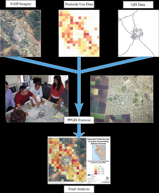
18 3) COLLECT THE DATA
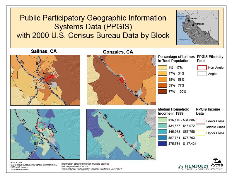
19 MULTIPLE RESEARCH METHODS Qualitative Key Informant Interviews Mapping of Environmental Data: State Pesticide Database Mapping Sociodemographic data U.S. Census Data Field Work-Data from Community Meetings Public Participation Mapping (PPGIS)
20 PUBLIC PARTICIPATION GIS (PPGIS) 1. On-the-ground knowledge of the region and its needs 2. Interacting with GIS technologies and analysts to meet those needs 3. Returning those GIS products for future use in directing policy change
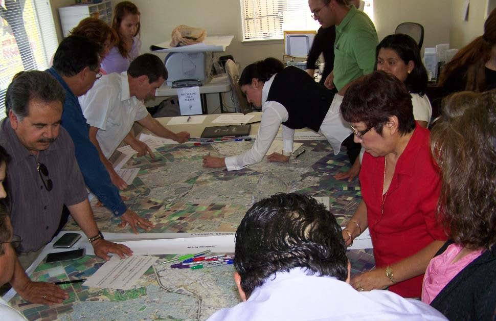
21 PPGIS 21
22 How many people really are hurt? We don t know; we don t know. We don t know those people who are hurt immediately Pesticides have been related to much more long term effects, such as Parkinson's, infertility, etc. We need a breakthrough that can only come through research. -Quote from community member in agricultural worker pesticide study

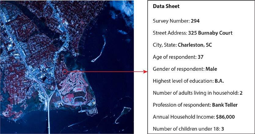
23 4) GEOCODE THE DATA: Using GPS, geocoding of addresses or other spatial information By hand, or using mobile devices with programs such as the Esri Collector app or Survey 123
.")
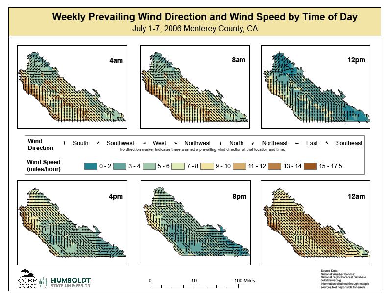
24 5) GROUND TRUTH THE DATA Ensures that what Is represented in your map or in your data file matches reality through on the ground field observation and/or comparison of mapped data with other sources (e.g. other maps, verbal accounts and or aerial photos).
25 25

26 THE NOTIFICATIONS THAT TAKE PLACE FOR SCHOOLS AND DAYCARES ARE FOR PESTICIDE USE ON THE SCHOOL GROUNDS ONLY! THERE IS NO NOTIFICATION FOR PESTICIDE USE ACROSS THE STREET IN THE FIELDS. IF IT HAPPENS AT ALL, IT IS VOLUNTARY. IT IS PURELY VOLUNTARY AND EXTREMELY RARE. IT IS NOT MANDATED BY ANY LAW. 26
27 PESTICIDES AFFECT COMMUNITIES Even if they aren t working in the fields they are affected by the fields because the town is surrounded by fields. Everybody fits the guise of being a farm worker because you are getting what is going on in the field. The communities are getting 95% of the crap that comes off of the fields. -Quote from community member in agricultural worker pesticide study
28 28

29 STEP 6) ANALYZE THE DATA (LOOK FOR SPATIAL AND SOCIAL PATTERNS)

30 30
31 31

32 WHERE ARE PESTICIDES LOCATED?

33 7) GENERATE THEORY A number of schools are located in areas of significant risk of pesticide drift and exposure.
34 THEORETICAL FRAMEWORK
35 POLICY IMPLICATIONS Develop Pesticide Free Agricultural Zones around schools, to benefit both growers and the community Tax Incentives or easements Increase communication between agencies and community regarding pesticide use Ensure that community members know who to alert when they observe unlawful pesticide use or drift Ensure the safety of farm workers who report unlawful & inappropriate use of pesticides
36 36
37 THE POWER OF SOCIOSPATIAL GROUNDED THEORY 1. Enables understanding of real world problems 2. Gives local communities a voice and role in defining problems and issues (as identified by the people who experience them) 3. Adapt to changes in the physical and social environment 4. Draw on existing community strengths (human capital, social capital, understanding of place) 5. Enables development of policy rooted in local culture, practice and empirical analysis
38 CONCLUSION Integrating GIS into education and planning helps to create multiple place-based interdisciplinary views of a situation/problem/issue Enables one to see the big picture Fosters better decision-making and REACTION to change Focuses where the geography of action (space, time and place) should occur.


39 GIS RESEARCH METHODS: INCORPORATING SPATIAL PERSPECTIVES Dr. Sheila Lakshmi Steinberg Professor, Social Sciences Brandman University Chapman University System Irvine, California Follow us on Esri Press (2015)
40 THANK YOU!!!
Conurbano s Atlas MALENA HOPP M A L H OO.COM. AR
 Conurbano s Atlas MALENA HOPP M A L ENAHOPP@YA H OO.COM. AR R ESEARCH GRO UP IN LIVING CONDITIONS IN BUENOS A I R ES CONURBANO. UNIVERSI DAD N ACIONAL DE AV E L L A N E DA Conurbano, an heterogeneous region
School of Geography and Geosciences. Head of School Degree Programmes. Programme Requirements. Modules. Geography and Geosciences 5000 Level Modules
 School of Geography and Geosciences Head of School Degree Programmes Graduate Diploma: Dr W E Stephens Health Geography Research Environmental History and Policy (see School of History) M.Res.: M.Litt.:
GEOG 3340: Introduction to Human Geography Research
 GEOG 3340: Introduction to Human Geography Research Lecture 1: Course Overview Guofeng Cao www.myweb.ttu.edu/gucao Department of Geosciences Texas Tech University guofeng.cao@ttu.edu Fall 2015 Course Description
Pathways. Pathways through the Geography Major
 Pathways through the Major majors may structure their course selections around a sub-field of. Pathways are suggestions for classes in, in related disciplines, and skills training. Each pathway includes
Introduction to the Geographical Sciences Committee. AAG Annual Meeting April 2017
 Introduction to the Geographical Sciences Committee AAG Annual Meeting April 2017 The National Academies of Sciences, Engineering, and Medicine Inform decision making and public policy Provide independent
The Importance of Spatial Literacy
 The Importance of Spatial Literacy Dr. Michael Phoenix GIS Education Consultant Taiwan, 2009 What is Spatial Literacy? Spatial Literacy is the ability to be able to include the spatial dimension in our
Tools to Assess Local Health Needs. Richard Leadbeater, Esri NACo 2011 Healthy Counties Forum December 1, 2011
 Tools to Assess Local Health Needs Richard Leadbeater, Esri NACo 2011 Healthy Counties Forum December 1, 2011 Richard Leadbeater currently holds the position of Industry Solutions Manager with Esri. He
St John s Catholic Primary School. Geography Policy. Mission Statement
 St John s Catholic Primary School Geography Policy Mission Statement We at St John s strive for excellence in education by providing a safe, secure and caring family environment where individuals are valued
California Reality and Nova Scotia Dreaming. Michael F. Goodchild University of California Santa Barbara
 California Reality and Nova Scotia Dreaming Michael F. Goodchild University of California Santa Barbara 1 The geospatial world Remote sensing Geographic information systems Automated cartography Global
GIS = Geographic Information Systems;
 What is GIS GIS = Geographic Information Systems; What Information are we talking about? Information about anything that has a place (e.g. locations of features, address of people) on Earth s surface,
National Disaster Management Centre (NDMC) Republic of Maldives. Location
 Republic of Maldives. Location") National Disaster Management Centre (NDMC) Republic of Maldives Location Country Profile 1,190 islands. 198 Inhabited Islands. Total land area 300 sq km Islands range b/w 0.2 5 sq km Population approx.
National Disaster Management Centre (NDMC) Republic of Maldives Location Country Profile 1,190 islands. 198 Inhabited Islands. Total land area 300 sq km Islands range b/w 0.2 5 sq km Population approx.
Techniques for Science Teachers: Using GIS in Science Classrooms.
 Techniques for Science Teachers: Using GIS in Science Classrooms. After ESRI, 2008 GIS A Geographic Information System A collection of computer hardware, software, and geographic data used together for
BIG IDEAS. Area of Learning: SOCIAL STUDIES Urban Studies Grade 12. Learning Standards. Curricular Competencies
 Area of Learning: SOCIAL STUDIES Urban Studies Grade 12 BIG IDEAS Urbanization is a critical force that shapes both human life and the planet. The historical development of cities has been shaped by geographic,
Core Courses for Students Who Enrolled Prior to Fall 2018
 Biostatistics and Applied Data Analysis Students must take one of the following two sequences: Sequence 1 Biostatistics and Data Analysis I (PHP 2507) This course, the first in a year long, two-course
How GIS can support the Production
 How GIS can support the Production of Local Development Plans ESRI User Conference 2017 Mandy Maas ARUP Who we are Shaping a better world We are an independent firm of designers, planners, engineers, consultants
An Introduction to Scientific Research Methods in Geography Chapter 3 Data Collection in Geography
 An Introduction to Scientific Research Methods in Geography Chapter 3 Data Collection in Geography Learning Objectives What is the distinction between primary and secondary data sources? What are the five
FIRE DEPARMENT SANTA CLARA COUNTY
 DEFINITION FIRE DEPARMENT SANTA CLARA COUNTY GEOGRAPHIC INFORMATION SYSTEM (GIS) ANALYST Under the direction of the Information Technology Officer, the GIS Analyst provides geo-spatial strategic planning,
The role of community in urban regeneration: mixed use areas approach in USA
 The role of community in urban regeneration: mixed use areas approach in USA Outline 1. Thesis 2. Main topics 3. Urban regeneration and community 4. Community involvement methods 5. Policies: EU vs USA
Social Geography for Mitigation: Developing Geo-narrative Media to Tell Your Client s Story
 Social Geography for Mitigation: Developing Geo-narrative Media to Tell Your Client s Story Julie Urbanik, Ph.D. Federal Public Defender Training, KC, MO April 27, 2017 Social Geography? Don t we already
Thilo Becker
 Friedrich List Faculty of Transport and Traffic Science, Chair of Transport Ecology CAN THE CONCEPT OF ENVIRONMENTAL JUSTICE IN TRANSPORT BE TRANSFERRED TO CITIES OF THE SOUTH? A CASE STUDY OF NAIROBI
Assessment and management of at risk populations using a novel GIS based UK population database tool
 Safety and Security Engineering 203 Assessment and management of at risk populations using a novel GIS based UK population database tool H. Balmforth 1, H. McManus 1 & A. Fowler 2 1 Health and Safety Laboratory,
compass.durhamnc.gov Building Community by Illustrating Community Durham s Neighborhood Compass
 Building Community by Illustrating Community Durham s Neighborhood Compass A presentation by John Killeen Rob Cushman Tyler Waring Neighborhood Improvement Services & Technology Solutions City of Durham,
Chapter 1. Why think spatially? Learning objectives. Key concepts
 Chapter 1 Why think spatially? In this chapter, you will learn a new approach to thinking spatially about research questions and methods. You will explore the following questions: Why think spatially?
Minnesota Transportation Museum
 Minnesota Transportation Museum Minnesota Social Studies s Alignment Second Grade 1 Code Benchmark 1. Citizenship and Government 1. Civic Skills. Civic Values and Principles of Democracy 4. Governmental
Dublin City Schools Social Studies Graded Course of Study Grade 5 K-12 Social Studies Vision
 K-12 Social Studies Vision The Dublin City Schools K-12 Social Studies Education will provide many learning opportunities that will help students to: develop thinking as educated citizens who seek to understand
The National Spatial Strategy
 Purpose of this Consultation Paper This paper seeks the views of a wide range of bodies, interests and members of the public on the issues which the National Spatial Strategy should address. These views
Creating a Staff Development Plan with Esri
 Creating a Staff Development Plan with Esri Michael Green David Schneider Guest Presenter: Shane Feirer, University of California Esri UC 2014 Technical Workshop Agenda What is a Staff Development Plan?
Letting reality speak. How the Chicago School Sociology teaches scholars to speak with our findings.
 Letting reality speak. How the Chicago School Sociology teaches scholars to speak with our findings. By Nanke Verloo n.verloo@uva.nl Assistant professor in Urban Planning, University of Amsterdam. Think
Presented at ESRI Education User Conference, July 6-8, 2001, San Diego, CA
 Presented at ESRI Education User Conference, July 6-8, 2001, San Diego, CA Irina V. Sharkova, Ph.D., Research Assistant Professor Richard Lycan, Ph.D., Senior Research Associate Population Research Center
Evaluating Sex Offender Exclusion Laws Alan Murray
 Evaluating Sex Offender Exclusion Laws Alan Murray Center for Urban and Regional Analysis and Department of Geography Ohio State University Columbus, OH 43210, USA Email: murray.308@osu.edu Outline Context
Linking Neighbourhood Data in the Analysis of Crime
 Linking Neighbourhood Data in the Analysis of Crime Professor Susan McVie University of Edinburgh CEBCP-SIPR Joint Symposium 8 th April 2013 The importance of crime mapping for policing in UK Understanding
Content Area: Social Studies Standard: 1. History Prepared Graduates: Develop an understanding of how people view, construct, and interpret history
 Standard: 1. History Develop an understanding of how people view, construct, and interpret history 1. Organize and sequence events to understand the concepts of chronology and cause and effect in the history
ASSESSING THE ARTS COMMUNITY: Mapping with GIS and Social Media Tools
 ASSESSING THE ARTS COMMUNITY: Mapping with GIS and Social Media Tools Gary Coutu Associate Professor Department of Geography and Planning West Chester University July 15, 2014 Mapping with GIS and Social
Rural Sociology (RU_SOC)
") Rural Sociology (RU_SOC) 1 Rural Sociology (RU_SOC) RU_SOC 1000: Rural Sociology Introduction to basic concepts and principles of sociology with a focus on rural populations and places. The course explores
Rural Sociology (RU_SOC) 1 Rural Sociology (RU_SOC) RU_SOC 1000: Rural Sociology Introduction to basic concepts and principles of sociology with a focus on rural populations and places. The course explores
Developing a Community Geographical Information System (GIS) in Rural India
 in Rural India") Developing a Community Geographical Information System (GIS) in Rural India Before rushing off and describing the unique challenges of developing a small scale GIS system India I better first describe
Developing a Community Geographical Information System (GIS) in Rural India Before rushing off and describing the unique challenges of developing a small scale GIS system India I better first describe
Augusta Canal National Heritage Area 8 Grade Lesson Plans. Stage 1 Desired Results
 Title: Falling into Place Stage 1 Desired Results Subject/Course: Grade: 8th Instructional Time: 10 hrs. Big Ideas: Geographic Regions, The Fall Line and Early Settlements, Rivers and Water Power, The
A Framework for the Study of Urban Health. Abdullah Baqui, DrPH, MPH, MBBS Johns Hopkins University
 This work is licensed under a Creative Commons Attribution-NonCommercial-ShareAlike License. Your use of this material constitutes acceptance of that license and the conditions of use of materials on this
Unit No-1&2. Settlement Geography
 Unit No-1&2 Settlement Geography TYPES OF SETTLEMENTS Rural Settlements - agriculture as the predominant occupation. Urban settlements - principal industries are secondary and tertiary. Rural Settlement:
Work-Based Learning Definitions State Agencies
 Work-Based Learning Definitions State Agencies Using Geographic Information Systems to Support Equitable Work-Based Learning Planning and Implementation OVERVIEW AND RESOURCES By Trent Sharp from the College
Diffusion of GIS in Public Policy Doctoral Program
 Diffusion of GIS in Public Policy Doctoral Program By Fulbert Namwamba PhD Southern University This presentation demonstrate how GIS was introduced in the Public Policy Doctoral Program at Southern University,
Great Native American Nations
 Great Native American Nations Episode 1 Episode 2 Episode 3 Episode 4 Episode 5 Episode 6 Cheyenne: Indians of the Plains Iroquois: Indians of the Northeast Lakota Sioux: Indians of the Plains Navajo:
Identifying Audit, Evidence Methodology and Audit Design Matrix (ADM)
") 11 Identifying Audit, Evidence Methodology and Audit Design Matrix (ADM) 27/10/2012 Exercise XXX 2 LEARNING OBJECTIVES At the end of this session participants will be able to: 1. Identify types and sources
11 Identifying Audit, Evidence Methodology and Audit Design Matrix (ADM) 27/10/2012 Exercise XXX 2 LEARNING OBJECTIVES At the end of this session participants will be able to: 1. Identify types and sources
ROUNDTABLE ON SOCIAL IMPACTS OF TIME AND SPACE-BASED ROAD PRICING Luis Martinez (with Olga Petrik, Francisco Furtado and Jari Kaupilla)
") ROUNDTABLE ON SOCIAL IMPACTS OF TIME AND SPACE-BASED ROAD PRICING Luis Martinez (with Olga Petrik, Francisco Furtado and Jari Kaupilla) AUCKLAND, NOVEMBER, 2017 Objective and approach (I) Create a detailed
ROUNDTABLE ON SOCIAL IMPACTS OF TIME AND SPACE-BASED ROAD PRICING Luis Martinez (with Olga Petrik, Francisco Furtado and Jari Kaupilla) AUCKLAND, NOVEMBER, 2017 Objective and approach (I) Create a detailed
GRADE 5 SOCIAL STUDIES SOCIAL STUDIES APPLICATION. SOCIAL STUDIES STANDARDS for Grade 5
 GRADE 5 SOCIAL STUDIES The Archdiocese of Cincinnati has established the following Social Studies standards based on the most current teachings which are aligned to Ohio New Learning Social Studies Standards.
Statistical perspectives on spatial social science
 Statistical perspectives on spatial social science Discussion Sarah Nusser (nusser@iastate.edu) Center for Survey Statistics and Methodology Department of Statistics Iowa State University Morris Hansen
GRADE 6 SOCIAL STUDIES SOCIAL STUDIES APPLICATION. SOCIAL STUDIES STANDARDS for Grade 6
 GRADE 6 SOCIAL STUDIES The Archdiocese of Cincinnati has established the following Social Studies standards based on the most current teachings which are aligned to Ohio New Learning Social Studies Standards.
COURSE INTRODUCTION & COURSE OVERVIEW
 week 1 COURSE INTRODUCTION & COURSE OVERVIEW topics of the week Instructor introduction Students introductions Course logistics Course objectives Definition of GIS The story of GIS introductions Who am
GOVERNMENT MAPPING WORKSHOP RECOVER Edmonton s Urban Wellness Plan Mapping Workshop December 4, 2017
 GOVERNMENT MAPPING WORKSHOP 12.4.17 RECOVER Edmonton s Urban Wellness Plan Mapping Workshop December 4, 2017 In July of 2017, City Council directed administration to develop RECOVER, Edmonton s Urban Wellness
CLAREMONT MASTER PLAN 2017: LAND USE COMMUNITY INPUT
 Planning and Development Department 14 North Street Claremont, New Hampshire 03743 Ph: (603) 542-7008 Fax: (603) 542-7033 Email: cityplanner@claremontnh.com www.claremontnh.com CLAREMONT MASTER PLAN 2017:
GREEN INFRASTRUCTURE, PARTICIPATORY MODELING, & DELIBERATIVE DEMOCRACY
 GREEN INFRASTRUCTURE, PARTICIPATORY MODELING, & DELIBERATIVE DEMOCRACY Katharine Travaline, Alex Waldman, & Franco Montalto, PhD September 27, 2011 Philadelphia Low Impact Development Symposium Introduction
Google Maps and Beyond
 Google Maps and Beyond Aaron Paul First American Title apaul@firstam.com 2015 APRA Symposium Association of Professional Reserve Analysts May 2 nd, 2015 Google Maps and Beyond - Overview Business case
Spatial Variation in Local Road Pedestrian and Bicycle Crashes
 2015 Esri International User Conference July 20 24, 2015 San Diego, California Spatial Variation in Local Road Pedestrian and Bicycle Crashes Musinguzi, Abram, Graduate Research Assistant Chimba,Deo, PhD.,
John Laznik 273 Delaplane Ave Newark, DE (302)
") Office Address: John Laznik 273 Delaplane Ave Newark, DE 19711 (302) 831-0479 Center for Applied Demography and Survey Research College of Human Services, Education and Public Policy University of Delaware
Office Address: John Laznik 273 Delaplane Ave Newark, DE 19711 (302) 831-0479 Center for Applied Demography and Survey Research College of Human Services, Education and Public Policy University of Delaware
Canadian Geo Course Introduction
 Canadian Geo 1202 Course Introduction Course Overview Unit 1 Natural and Human Systems (SCO 1.0 and SCO 2.0) - What happens when systems interact? In this unit students are challenged to reflect on the
Applying Health Outcome Data to Improve Health Equity
 Applying Health Outcome Data to Improve Health Equity Devon Williford, MPH, Health GIS Specialist Lorraine Dixon-Jones, Policy Analyst CDPHE Health Equity and Environmental Justice Collaborative Mile High
Prentice Hall. World Explorer: People, Places, Cultures Grade 7. Oklahoma Priority Academic Student Skills (PASS) for Grade 7 World Geography
 for Grade 7 World Geography") Prentice Hall World Explorer: People, Places, Cultures 2007 Grade 7 C O R R E L A T E D T O for Grade 7 1. Locate, gather, analyze, and apply information from primary and secondary sources. WORLD GEOGRAPHY
Prentice Hall World Explorer: People, Places, Cultures 2007 Grade 7 C O R R E L A T E D T O for Grade 7 1. Locate, gather, analyze, and apply information from primary and secondary sources. WORLD GEOGRAPHY
Grade Four Content Overview
 Grade Four Content Overview Physical features Regions Contributions of the states Our Country: Geography and Regions Coastal and inland communities Famous landmarks Physical and human characteristics Local,
Datahoods or Data-Driven Neighborhoods. Using GIS to better understand neighborhoods
 Datahoods or Data-Driven Neighborhoods Using GIS to better understand neighborhoods Who am I? Silas Toms President, Loki Intelligent Corporation Author, ArcPy and ArcGIS (2 editions) Co-Host of the Mappyist
Grade Level, Course Third Grade Social Studies PLSD Balanced Assessment Practices. Type* DOK
 Unit Guides Assessment Items Indic ator s Concept Standard Curricular Indicator DOK Type* SR CR PB Assessment Questions # DOK Level 1E 1M 1H 2E 2M 2H 3E 3M 3H Civics Students will develop and apply the
Are You Maximizing The Value Of All Your Data?
 Are You Maximizing The Value Of All Your Data? Using The SAS Bridge for ESRI With ArcGIS Business Analyst In A Retail Market Analysis SAS and ESRI: Bringing GIS Mapping and SAS Data Together Presented
GeoHealth Applications Platform ESRI Health GIS Conference 2013
 GeoHealth Applications Platform ESRI Health GIS Conference 2013 Authors Thomas A. Horan, Ph.D. Professor, CISAT Director April Moreno Health GeoInformatics Ph.D. Student Brian N. Hilton, Ph.D. Clinical
Culture and Urban Revitalization
 University of Pennsylvania ScholarlyCommons Culture and Community Revitalization: A Collaboration Social Impact of the Arts Project 6-2007 Culture and Urban Revitalization Mark J. Stern University of Pennsylvania,
Your web browser (Safari 7) is out of date. For more security, comfort and. the best experience on this site: Update your browser Ignore
 is out of date. For more security, comfort and. the best experience on this site: Update your browser Ignore") Your web browser (Safari 7) is out of date. For more security, comfort and Activityengage the best experience on this site: Update your browser Ignore Introduction to GIS What is a geographic information
Your web browser (Safari 7) is out of date. For more security, comfort and Activityengage the best experience on this site: Update your browser Ignore Introduction to GIS What is a geographic information
GEOGRAPHY POLICY STATEMENT. The study of geography helps our pupils to make sense of the world around them.
 GEOGRAPHY POLICY STATEMENT We believe that the study of geography is concerned with people, place, space and the environment and explores the relationships between the earth and its peoples. The study
What is new at ArcGIS 10.2? David Parry
 What is new at ArcGIS 10.2? David Parry What s new http://www.esri.com/software/ arcgis/arcgis10/features http://resources.arcgis.com/en/help/main/10.2/# /What_s_new_in_ArcGIS_10_2/016w0000005s 000000/
Fifth Grade Social Studies Major Instructional Goals
 Fifth Grade Social Studies Major Instructional Goals We exist for the academic excellence of all students. December 2007 1 Rationale The purpose of the social studies program is to prepare young people
ECONOMIC AND SOCIAL COUNCIL 13 July 2007
 UNITED NATIONS E/CONF.98/CRP.34 ECONOMIC AND SOCIAL COUNCIL 13 July 2007 Ninth United Nations Conference on the Standardization of Geographical Names New York, 21-30 August 2007 Item 17(b) of the provisional
Advanced Readings. Environment and Land Use Concentration The following seminars and studios would apply
 Community Development and Housing Concentration URP 720 Urban Housing Policies URP 722 Community Development and Housing URP 724 Urban Revitalization Studio URP 726 Citizen Participation Strategies URP
for an Informed Analysis of A Socio-Economic Perspective Adrijana Car, Marike Bontenbal and Marius Herrmann
 Creating a GIS-Base for an Informed Analysis of Tourism Development: A Socio-Economic Perspective Adrijana Car, Marike Bontenbal and Marius Herrmann adrijana.car@gutech.edu.om edu GSS 2012 Affiliated to:
GIS Test Drive What a Geographic Information System Is and What it Can Do. Alison Davis-Holland
 GIS Test Drive What a Geographic Information System Is and What it Can Do Alison Davis-Holland adavisholland@gmail.com WHO AM I? Geospatial Analyst M.S. in Geographic and Cartographic Sciences Use GIS
Unit of Study: Physical Geography & Settlement Patterns; Culture & Civilizations; and The Spread of Ideas
 6 th Grade Social Studies 1 st Nine Weeks TEKS Unit of Study: Physical Geography & Settlement Patterns; Culture & Civilizations; and The Spread of Ideas 6.1) History. The student understands that historical
A spatial literacy initiative for undergraduate education at UCSB
 A spatial literacy initiative for undergraduate education at UCSB Mike Goodchild & Don Janelle Department of Geography / spatial@ucsb University of California, Santa Barbara ThinkSpatial Brown bag forum
Minnesota K-12 Academic Standards in Social Studies. Grade 4: Geography of North America
 Minnesota K-12 Academic s in Social Studies Grade 4: Geography of North America 4 Describe how people take 1. Democratic government action to influence a depends on informed and decision on a specific
GEOGRAPHY (GEOGRPHY) Geography (GEOGRPHY) 1
 Geography (GEOGRPHY) 1") Geography (GEOGRPHY) 1 GEOGRAPHY (GEOGRPHY) GEOGRPHY 1040 Planet Earth 4 Credits The features of the natural environment (lithosphere, atmosphere and hydrosphere); their character, distribution, origin
Geography (GEOGRPHY) 1 GEOGRAPHY (GEOGRPHY) GEOGRPHY 1040 Planet Earth 4 Credits The features of the natural environment (lithosphere, atmosphere and hydrosphere); their character, distribution, origin
Strand 1: Principles of Constitutional Democracy. Strand 2: Principles and Processes of Governance Systems
 Social Studies GLE S - Grade 4 Strand 1: Principles of Constitutional Democracy 1. Knowledge of the principles expressed in documents shaping constitutional democracy in the United States A. Knowledge
Cultural Data in Planning and Economic Development. Chris Dwyer, RMC Research Sponsor: Rockefeller Foundation
 Cultural Data in Planning and Economic Development Chris Dwyer, RMC Research Sponsor: Rockefeller Foundation A Decade of Attempts to Quantify Arts and Culture Economic impact studies Community indicators
Environmental Analysis, Chapter 4 Consequences, and Mitigation
 Environmental Analysis, Chapter 4 4.17 Environmental Justice This section summarizes the potential impacts described in Chapter 3, Transportation Impacts and Mitigation, and other sections of Chapter 4,
POLITICAL SYSTEMS. (ps ) Evaluate positions taken regarding the necessity of government and the purposes of government.
 Evaluate positions taken regarding the necessity of government and the purposes of government.") Baltimore City Public School System Social Studies Content Standards (Grade 8) POLITICAL SYSTEMS In the context of U.S. History through 1877, at the end of grade 8, students know and are able to do everything
Baltimore City Public School System Social Studies Content Standards (Grade 8) POLITICAL SYSTEMS In the context of U.S. History through 1877, at the end of grade 8, students know and are able to do everything
Use of Geospatial data for disaster managements
 Use of Geospatial data for disaster managements Source: http://alertsystemsgroup.com Instructor : Professor Dr. Yuji Murayama Teaching Assistant : Manjula Ranagalage What is GIS? A powerful set of tools
The Case for Space in the Social Sciences
 The Case for Space in the Social Sciences Don Janelle Center for Spatially Integrated Social Science University of California, Santa Barbara Roundtable on Geographical Voices and Geographical Analysis
11/11/2016. Energy Impacts Research Coordination Network >>>
 Energy Impacts Research Coordination Network >>> www.energyimpacts.org Synergies and Innovations in Coordinating Energy Impacts Research: The Case of Shale Development Impacts November 10, 2016, 1:30 2:30
Does city structure cause unemployment?
 The World Bank Urban Research Symposium, December 15-17, 2003 Does city structure cause unemployment? The case study of Cape Town Presented by Harris Selod (INRA and CREST, France) Co-authored with Sandrine
GIS for Crime Analysis. Building Better Analysis Capabilities with the ArcGIS Platform
 GIS for Crime Analysis Building Better Analysis Capabilities with the ArcGIS Platform Crime Analysis The Current State One of the foundations of criminological theory is that three things are needed for
K- 5 Academic Standards in. Social Studies. June 2013
 K- 5 Academic s in Social Studies June 203 Word Tables of s ONLY This Word version of the 2.7.2 social studies standards (DRAFT for Rulemaking 2.7.2) document contains the standards ONLY; no explanatory
AP HUG REVIEW WELCOME TO 2 ND SEMESTER! Annette Parkhurst, M.Ed. January, 2015
 AP HUG REVIEW WELCOME TO 2 ND SEMESTER! Annette Parkhurst, M.Ed. January, 2015 Movement Globalization Latitude & Elevation Levels of Economic Activities CONNECTIONS Human Geography Human is the geography
Demographic Data in ArcGIS. Harry J. Moore IV
 Demographic Data in ArcGIS Harry J. Moore IV Outline What is demographic data? Esri Demographic data - Real world examples with GIS - Redistricting - Emergency Preparedness - Economic Development Next
DATA DISAGGREGATION BY GEOGRAPHIC
 PROGRAM CYCLE ADS 201 Additional Help DATA DISAGGREGATION BY GEOGRAPHIC LOCATION Introduction This document provides supplemental guidance to ADS 201.3.5.7.G Indicator Disaggregation, and discusses concepts
Unlocking the Power of Geographic Inquiry. Thomas Herman, PhD Director, California Geographic Alliance Department of Geography, San Diego State Univ.
 Unlocking the Power of Geographic Inquiry Thomas Herman, PhD Director, California Geographic Alliance Department of Geography, San Diego State Univ. Why I am here, and how I got here A few words about
6/25/2018. Upcoming Classes After Today. Our Only Presentation Day: Monday, July 2
 Upcoming Classes After Today Tuesday (June 26): Pacific Northwest and the Northlands Wednesday (June 27): Geographic Literacy in America; Take-Home Midterm Exam #2 distributed and discussed Thursday (June
GIS. in the City of Lewiston Maine
 GIS in the City of Lewiston Maine The purpose of this slideshow is to provide an overview of the city GIS and how it is used, maintained and accessed in-house as well as by the public. Please simply hit
FHWA GIS Outreach Activities. Loveland, Colorado April 17, 2012
 FHWA GIS Outreach Activities Loveland, Colorado April 17, 2012 GIS for Improved Decision Making FHWA believes that geographic information systems and other geospatial technologies (remote sensing and GPS)
A Map Through Time Virtual Historic Cities
 A Map Through Time Virtual Historic Cities NEW WAYS OF EXPLORING DIGITAL COLLECTIONS FLORIDA INTERNATIONAL UNIVERSITY JAMIE ROGERS Coral Gables Virtual Historic City & Unearthing St. Augustine s Colonial
Space Syntax: Architecture and Cities MRes This programme information sheet includes details of the structure and content of the course.
 Space Syntax: Architecture and Cities MRes 2018-19 This programme information sheet includes details of the structure and content of the course. CONTENTS Overview 3 Structure 4 Content 5 Staff 6 Opportunities
GIS Spatial Statistics for Public Opinion Survey Response Rates
 GIS Spatial Statistics for Public Opinion Survey Response Rates July 22, 2015 Timothy Michalowski Senior Statistical GIS Analyst Abt SRBI - New York, NY t.michalowski@srbi.com www.srbi.com Introduction
Kindergarten: Foundations of Social Studies
 4. Governmental Institutions and Political Processes 1. Citizenship and Government 2. Civic Values and Principles of Democracy 1.Civic Skills indergarten: Foundations of Social Studies In kindergarten,
Social Studies I. Scope and Sequence. Quarter 1
 Quarter 1 Unit 1.1, Global Interactions (10 days) HP 2: History is a chronicle of human activities, diverse people, and the societies they form. (9-12) 3 Students show understanding of change over time
SOCIAL STUDIES GRADE 6. I Can Checklist REGIONS AND PEOPLE OF THE EASTERN HEMISPHERE. Office of Teaching and Learning Curriculum Division
 SOCIAL STUDIES REGIONS AND PEOPLE OF THE EASTERN HEMISPHERE GRADE 6 I Can Checklist 2018-2019 Aligned with Ohio s Learning Standards for Social Studies Office of Teaching and Learning Curriculum Division
Geography Policy. for Hertsmere Jewish Primary School
 Geography Policy for Hertsmere Jewish Primary School Reviewed by: L Rubin Reviewed on: September 2017 Date of Next Review: September 2018 Policy Review This policy will be reviewed in full by the Governing
PLANNING (PLAN) Planning (PLAN) 1
 Planning (PLAN) 1") Planning (PLAN) 1 PLANNING (PLAN) PLAN 500. Economics for Public Affairs Description: An introduction to basic economic concepts and their application to public affairs and urban planning. Note: Cross-listed
Planning (PLAN) 1 PLANNING (PLAN) PLAN 500. Economics for Public Affairs Description: An introduction to basic economic concepts and their application to public affairs and urban planning. Note: Cross-listed
A.P. Human Geography
 A.P. Human Geography 2012-2013 Instructor: Chris Vitt Brief Description of Course AP Human Geography is designed to provide students with a learning experience equivalent to that obtained in most college