CPTED in Latin America
|
|
|
- Eleanor Ford
- 6 years ago
- Views:
Transcription
1 CPTED in Latin America Measurement & Evaluation A piloted model Ma. Macarena Rau Dr. Tim Pascoe

2 Partnership Our Credentials: International CPTED Association CPTED Corporación Region LAC UK Institute of Community Safety UK Design Out Crime Association Community Safety Europe Caribbean Crime Prevention International PBK Consulting Griffin Research & Consultancy Catalyst In Communities Community Coaching Academy
3 Context is Everything Latin American context is different to traditional CPTED environments typified by North America, Europe and Australasia. LA is one of the most dangerous areas in the world. UN suggest it is the only region in the world where murder rates are increasing. Robberies have nearly trebled over the past 25 years; extortion is growing fast. Fear of crime is twice that of North America.
4 Historic Approaches Traditionally most Latin American countries have focused on dealing with crime with a reactive and enforcement led approach known as the mano dura, or the militarised ironfist policy. However, since around the year 2000 community approaches have become more common. For example in 2010 the Colombian police implemented a Quadrant Plan dividing urban areas into territorial beats in order to adopt a more localised approach. The Chilean police implemented also the same plan since 2000 in Chile.
5 Latin America CPTED Approach Led by Macarena Rau and CPTED Chilean Team. Regional and National ICA s (Corporación CPTED Chile, 2004; Corporación CPTED Region, 2011) CPTED methodologies were introduced into four countries in the early 2000 s: Chile, Brazil, El Salvador and Honduras. Now CPTED is very spread in Mexico also. More recent work part of this project
6 CPTED Approach Issues CPTED in Latín America is seen as a realatively new concept and there is no scientifically validated model yet to measure and evaluate the impact of these strategies on: urban settings the processes of citizen participation local municipal management This makes slowly to justify its application!
7 Research Question 1. Does the implementation of Crime Prevention Through Environmental Design strategies have a positive impact on communities by reducing crime (murder and robbery) and fear of crime?; and if it is true. 2. How can you measure the impact?
8 Expectations Low impact on murder Medium impact on robbery High impact on fear of crime
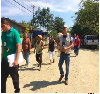
9 Research methodology Before and after comparisons of CPTED cases in Chile, Honduras & Patagonia. Compare action sites to control sites in same locations. Design both quantitative and qualitative collection tools. Recognise that this is an action based research pragmatic. Analyse the data taking a problem solving approach.
10 Reducing Crime There is never a Silver Bullet solution to crime & disorder problems. No single agency that holds all the solutions. Permanent police presence is not sustainable. Community engagement is essential. A simple model exists for framing this approach to problems the S.A.R.A. model.
11 Evidence Based SARA Problem Solving Model
12 Evidence Based SARA Problem Solving Model Scanning
13 Evidence Based SARA Problem Solving Model Scanning Analysis
14 Evidence Based SARA Problem Solving Model Scanning Analysis Response

15 Evidence Based SARA Problem Solving Model Scanning Assessment Analysis Response
16 Basic action evaluation model Establish the start point for measurement (baseline) Agree performance measures Set targets Decide responsibilities Collect progress data Compare with targets Provide feedback Intervene if necessary Collect achievement data Compare with targets Seek explanations Disseminate results
17 Data Collection Official data e.g. crime data Questionnaires completed by residents & professional stakeholders Interviews residents, offenders & professional stakeholders Workshops Community group support
18 Data collection Data is being collected using the methods indicated in the test site and a matched control site in Chile, Honduras and Patagonia. The variables of this data will be under the three headings:: Urban Setting, Community Involvement, Local Governance.
19 Urban Settings We link CPTED methodology to define variables according to 5 fundamental principles. 1. Natural surveillance: lighting, formal surveillance. 2. Territorial reinforcement: mural graffiti, territorial marks in commerce and equipment v/s marks territorial in squares. 3. Natural access control: urban access, residential passages, alarms. 4. Maintenance: vandalism and signage. 5. Community participation: neighbours or residents take up space.
20 Community Involvement Residents use of public space Participation of neighbours in the design of situational prevention project Presence of young people
21 Local Governance Municipal coordination meetings Mobile security in the neighbourhood Operational policing Police staffing in the neighbourhood
22 Benchmark Data Benchmark data will be collected for all sites with community involvement. Then the data will be analyzed to set the benchmarks for comparison and to identify Interventions under our 3 variables headings and to supervise actioning those interventions.
23 On-going data Periodically additional data will be collected and progress measured. Results from this analysis will be used to adjust any interventions if needed.
24 Final Data Once the interventions have been completed and have been running for a period of time the final results will be analyzed. These will show: 1. If we had a ± effect on the neighborhoods and what caused those effects 2. If our model of evaluation worked and how it can be improved 3. Answer the research question
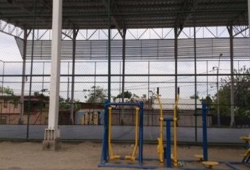
25 Pilot Sites & Progress to Date Honduras Chile Patagonia
26 Early Results Chile
27 Pedro Aguirre Cerda (PAC), Puente Alto, Chile. The Pedro Aguirre Cerda population is located in the west of the commune of Puente Alto in Santiago de Chile between streets Concha y Toro, Covadonga, Abate Molina and Ramón Barros Luco. It has peripheral features, which leads to poor accessibility to public transport and services.
28 Drugs and Robbery Are Significant Issues

29 Population Breakdown Cuadro N 1 Fuente: Datos ficha de protección social 2012.
30 Robbery with violence or intimidation.
31


32 Intervention Recreational Area


33 Intervention Street Improvements.


34 Intervention Drug Hot Spots & Poor Environmental Areas
35 Early Results Honduras

36 La Laguna, Honduras. La Laguna was founded in 2002 and is adjacent to the North with Col. 15 of September, to the South with El Retiro neighborhood, on the East by neighborhood of Las Lomas, West with Río Hiland Creek and Hiland Creek neighborhood

37 Aspectos Demográficos Datos Censo Poblacional INE 2001, datos cantidad.

38 Homicide and Drugs Crime


39 Intervention at Drug Hostspots
40 Questionaire It is divided into two areas with 42 questions: A) the first regarding dependent variables which are theft, homicide, perception of insecurity and community network. B) the second with respect to independent variables that correspond to the field: urban settings, community participation and local governance. The independent variables are constructed from typological CPTED and situational prevention projects that are carried out in different districts vulnerable in the LAC region and in particular in the two wards that make up this research study cases. Is designed as a questionnaire autoaplicado for over 14 years for both genders.

41
42 Questionaires Applied 120 surveys during August and September surveys in Chile and 60 surveys in Honduras. These are applied in PAC 30 and 30 in adjacent populations used as control without situational intervention group. The same happens in Honduras where they apply 30 in the lagoon and 30 in the September 15 colony used as population control group.

43

44

45 8. Resultados de la Encuesta
46 Current State of Play Beginning to analyse data Results at next conference However using an evidence based approach to explain any impact
47 CPTED impact key causal/explanatory concepts: 1. NEIGHBORHOOD 2. IMAGE OF STREET/HOME 3. POINTS NODAL, ACCESS AND REASONS TO ACCESS 4. VOLUME OF TRAFFIC AND TRANQUILITY OF TRAFFIC KIND OF TERRITORIALITY/SPACE 5. DEFENSIBLE PATH ON THE STREET AND HOUSE 6. LIGHTING OF STREETS 7. COMMUNITY COHESION 8. TYPE OF HOUSING AND NATURAL SURVEILLANCE POSITION. 9. TARGET HARDENING

48 Muchas Gracias!
Linking Neighbourhood Data in the Analysis of Crime
 Linking Neighbourhood Data in the Analysis of Crime Professor Susan McVie University of Edinburgh CEBCP-SIPR Joint Symposium 8 th April 2013 The importance of crime mapping for policing in UK Understanding
RETA 6422: Mainstreaming Environment for Poverty Reduction Category 2 Subproject
 RETA 6422: Mainstreaming Environment for Poverty Reduction Category 2 Subproject A. Basic Data 1. Subproject Title: Poverty-Environment Mapping to Support Decision Making 2. Country Director: Adrian Ruthenberg
City and SUMP of Ravenna
 City and SUMP of Ravenna Nicola Scanferla Head of Mobility Planning Unit, Municipality of Ravenna nscanferla@comune.ra.it place your logo here 19 April, 2017 1st Steering Committee Meeting, Nicosia, Cyprus
Space and the City: Modern Chicago (and Beyond)
") Space and the City: Modern Chicago (and Beyond) Robert J. Sampson Department of Sociology Harvard University Concentration of Collective Action Events in Chicago Spatial Interdependence of Concentrated
Space and the City: Modern Chicago (and Beyond) Robert J. Sampson Department of Sociology Harvard University Concentration of Collective Action Events in Chicago Spatial Interdependence of Concentrated
Methodology used in preparing the estimates and projections of the urban and rural population and the economically active population
 CEPAL América Latina y el Caribe. Observatorio demográfico Nº 2 Población económicamente activa Methodology used in preparing the estimates and projections of the urban and rural population and the economically
Public Disclosure Copy
 Public Disclosure Authorized LATIN AMERICA AND CARIBBEAN Brazil Agriculture Global Practice IBRD/IDA Investment Project Financing FY 2010 Seq No: 16 ARCHIVED on 26-Jun-2018 ISR33043 Implementing Agencies:
Shaping Your Neighbourhood
 Shaping Your Neighbourhood Building a Core Sustainable Neighbourhood Action Plan Nov. 25 & 26, 2006 Welcome! Peter Russell Planner, Holland Barrs Planning Group Inc. Role in this project: Work with the
Community Engagement in Cultural Routes SiTI Higher Institute on Territorial Systems for Innovation Sara Levi Sacerdotti
 Transnational Workshop Wroclaw, 7th-8th December 2016 Community Engagement in Cultural Routes SiTI Higher Institute on Territorial Systems for Innovation Sara Levi Sacerdotti levi@siti.polito.it TAKING
CONFERENCE STATEMENT
 Final draft CONFERENCE STATEMENT We, the elected representatives of Canada, Denmark/Greenland, the European Parliament, Finland, Iceland, Norway, Russia, Sweden and the United States of America; In collaboration
Measurement of the Urban-Housing Deficit:
 Measurement of the Urban-Housing Deficit: Strategies, tools and sources of information The International Network for Urban and Regional Statistics Standing Committee of the International Association for
INCLUSIVE URBAN REGENERATION IN JOHANNESBURG: The Case of Ekhaya Residential City Improvement District in Hillbrow
 INCLUSIVE URBAN REGENERATION IN JOHANNESBURG: The Case of Ekhaya Residential City Improvement District in Hillbrow HISTORICAL OVERVIEW: HILLBROW JOHANNESBURG EARLY ESTABLISHMENT & DEVELOPMENT POLITICS:
Public Disclosure Copy
 Public Disclosure Authorized LATIN AMERICA AND CARIBBEAN Brazil Agriculture Global Practice IBRD/IDA Investment Project Financing FY 2010 Seq No: 15 ARCHIVED on 29-Dec-2017 ISR30320 Implementing Agencies:
International Guidelines on Access to Basic Services for All
 International Guidelines on Access to Basic Services for All Presentation and initials lessons from implementation Accessibility to services in regions and cities : measures and policies, OECD 18 June
Smart City Governance for effective urban governance. David Ludlow Assoc. Professor European Smart Cities University of the West of England, Bristol
 Smart City Governance for effective urban governance David Ludlow Assoc. Professor European Smart Cities University of the West of England, Bristol Complexities of urban territorial governance Complexities
GOVERNMENT MAPPING WORKSHOP RECOVER Edmonton s Urban Wellness Plan Mapping Workshop December 4, 2017
 GOVERNMENT MAPPING WORKSHOP 12.4.17 RECOVER Edmonton s Urban Wellness Plan Mapping Workshop December 4, 2017 In July of 2017, City Council directed administration to develop RECOVER, Edmonton s Urban Wellness
Crime Analysis. GIS Solutions for Intelligence-Led Policing
 Crime Analysis GIS Solutions for Intelligence-Led Policing Applying GIS Technology to Crime Analysis Know Your Community Analyze Your Crime Use Your Advantage GIS aids crime analysis by Identifying and
World Bank Group GEF Program
 World Bank Group GEF Program Global Environment Facility: -Transport World Bank GEF Coordination Team Content How does GEF work? World Bank s role in the GEF partnership The GEF transport activities What
Community Participation in Land Governance Through Citywide Community Mapping GLTN Learning Exchange, Bayview Hotel, Manila November 7, 2017
 Community Participation in Land Governance Through Citywide Community Mapping GLTN Learning Exchange, Bayview Hotel, Manila November 7, 2017 Community-Led, Citywide Settlement Profiling and Mapping as
Join our team! The Drexel Urban Health Collaborative is recruiting for a Data Analyst position.
 Join our team! The Drexel Urban Health Collaborative is recruiting for a Data Analyst position. This position will support a large, multisite, international urban health research project involving several
ACCESSIBILITY TO SERVICES IN REGIONS AND CITIES: MEASURES AND POLICIES NOTE FOR THE WPTI WORKSHOP, 18 JUNE 2013
 ACCESSIBILITY TO SERVICES IN REGIONS AND CITIES: MEASURES AND POLICIES NOTE FOR THE WPTI WORKSHOP, 18 JUNE 2013 1. Significant differences in the access to basic and advanced services, such as transport,
KUNMING FORUM ON UNITED NATIONS GLOBAL GEOSPATIAL INFORMATION MANAGEMENT CITIES OF THE FUTURE: SMART, RESILIENT
 KUNMING FORUM ON UNITED NATIONS GLOBAL GEOSPATIAL INFORMATION MANAGEMENT CITIES OF THE FUTURE: SMART, RESILIENT and SUSTAINABLE Yunnan Zhenzhuang Guest House, Kunming, China 10 12 May 2017 BACKGROUND CONCEPT
Tackling urban sprawl: towards a compact model of cities? David Ludlow University of the West of England (UWE) 19 June 2014
 19 June 2014") Tackling urban sprawl: towards a compact model of cities? David Ludlow University of the West of England (UWE) 19 June 2014 Impacts on Natural & Protected Areas why sprawl matters? Sprawl creates environmental,
Tackling urban sprawl: towards a compact model of cities? David Ludlow University of the West of England (UWE) 19 June 2014 Impacts on Natural & Protected Areas why sprawl matters? Sprawl creates environmental,
Sommet Mondial des Dirigeants Locaux et Régionaux 4 ème Congrès de CGLU Rabat, 1 er octobre _130 CGLU Rabat
 Mobilité et accessibilité dans les zones urbaines en Afrique : Préparation d un document de synthèse sur les tendances actuelles, les questions émergentes et le choix de stratégies à adopter Sommet Mondial
The Effectiveness of Strategies for Crime Reduction in Areas of Public Housing Concentration
 The Effectiveness of Strategies for Crime Reduction in Areas of Public Housing Concentration Bruce Judd Robert Samuels Jack Barton UNSW-UWS AHURI Research Centre ABSTRACT Vulnerability to crime is a common
Urbanization and Sustainable Development of Cities: A Ready Engine to Promote Economic Growth and Cooperation
 Urbanization and Sustainable Development of Cities: A Ready Engine to Promote Economic Growth and Cooperation Wan Portia Hamzah Institute of Strategic and International Studies (ISIS) Malaysia 10 September
Letting reality speak. How the Chicago School Sociology teaches scholars to speak with our findings.
 Letting reality speak. How the Chicago School Sociology teaches scholars to speak with our findings. By Nanke Verloo n.verloo@uva.nl Assistant professor in Urban Planning, University of Amsterdam. Think
Measuring Disaster Risk for Urban areas in Asia-Pacific
 Measuring Disaster Risk for Urban areas in Asia-Pacific Acknowledgement: Trevor Clifford, Intl Consultant 1 SDG 11 Make cities and human settlements inclusive, safe, resilient and sustainable 11.1: By
The World Bank NI Sustainable Rural Water Supply and Sanitation Sector (P147006)
") Public Disclosure Authorized LATIN AMERICA AND CARIBBEAN Nicaragua Water Global Practice IBRD/IDA Investment Project Financing FY 2014 Seq No: 5 ARCHIVED on 16-Dec-2015 ISR21478 Implementing Agencies:
Public Disclosure Authorized LATIN AMERICA AND CARIBBEAN Nicaragua Water Global Practice IBRD/IDA Investment Project Financing FY 2014 Seq No: 5 ARCHIVED on 16-Dec-2015 ISR21478 Implementing Agencies:
Crime and Fire Statistics
 Monmouth University Police Department Crime Statistics Murder Negligent Manslaughter Forcible Sex Offenses Rape Criminal Sexual Contact Non-Forced Sex Offenses Incest Statutory Rape Robbery Aggravated
2018/1 The integration of statistical and geospatial information. The Regional Committee of UN-GGIM: Americas:
 The following are the conclusions and recommendations of the Regional Committee of the United Nations on Global Geospatial Information Management for the Americas, during its Fifth Session, Thursday 8
Council Workshop on Neighbourhoods Thursday, October 4 th, :00 to 4:00 p.m. Burlington Performing Arts Centre
 Council Workshop on Neighbourhoods Thursday, October 4 th, 2012 1:00 to 4:00 p.m. Burlington Performing Arts Centre Agenda Introductions Warm-Up Exercise Presentation Exercise Neighbourhood Planning Break
Implementation Status & Results Belize Municipal Development (P111928)
") losure Authorized Public Disclosure Authorized Public Disclosure Authorized Public Disclosure Authorized The World Bank Implementation Status & Results Belize Municipal Development (P111928) Operation
losure Authorized Public Disclosure Authorized Public Disclosure Authorized Public Disclosure Authorized The World Bank Implementation Status & Results Belize Municipal Development (P111928) Operation
Preparing the GEOGRAPHY for the 2011 Population Census of South Africa
 Preparing the GEOGRAPHY for the 2011 Population Census of South Africa Sharthi Laldaparsad Statistics South Africa; E-mail: sharthil@statssa.gov.za Abstract: Statistics South Africa (Stats SA) s Geography
Dossier. Spaces of Insecurity Security Governance in Latin America Revisited. Coordinated by Anja Feth and Markus-Michael Müller
 Rev41-01 10/3/11 11:56 Página 77 Dossier Spaces of Insecurity Security Governance in Latin America Revisited Coordinated by Anja Feth and Markus-Michael Müller Rev41-01 10/3/11 11:56 Página 79 Anja Feth/Markus-Michael
PAN AMERICAN INSTITUTE OF GEOGRAPHY AND HISTORY Specialized Organization of the OAS
 PAN AMERICAN INSTITUTE OF GEOGRAPHY AND HISTORY Specialized Organization of the OAS 10 th UNRCC Americas United Nations, New York, 20 August 2013 PAIGH, SIRGAS, PC-IDEA and GeoSUR 2013-2015 Joint Action
ACTION PLAN FOR WORLD HERITAGE IN LATIN AMERICA AND THE CARIBBEAN ( )
") Annex ACTION PLAN FOR WORLD HERITAGE IN LATIN AMERICA AND THE CARIBBEAN (2014-2024) The current Regional Action Plan for Latin America and the Caribbean for 2014-2024 has been elaborated by the State Parties
Annex ACTION PLAN FOR WORLD HERITAGE IN LATIN AMERICA AND THE CARIBBEAN (2014-2024) The current Regional Action Plan for Latin America and the Caribbean for 2014-2024 has been elaborated by the State Parties
Map 1: Seismic Hazard Map of South Asia Region. Z = Seismic Zoning Factor for Design of Buildings in Nepal Map 2: Seismic zoning of Nepal
 National Society for Earthquake Technology-Nepal (NSET) is implementing the program Promoting Public Private Partnership for Earthquake Risk Management (3PERM) with the funding support from United States
Experience and perspectives of using EU funds and other funding for the implementation of district renovation projects
 Experience and perspectives of using EU funds and other funding for the implementation of district renovation projects Ministry of the Interior of Lithuania Regional policy department Administration, coordination,
Introduction to time-use surveys
 Regional seminar on time-use surveys Introduction to time-use surveys Kingstown, Saint Vincent and the Grenadines 10-11 December 2014 Iliana Vaca Lucía Scuro Division of Gender Affairs WHAT IS TIME? Measured
Percent Change. Last YTD
 Part I L Month Month HOMICIDE 1 0 5 3 66.7% 1 4 3 100.0% 80.0% 100.0% 0 0 0 2 6 8 MURDER 0 0 4 1 300.0% 0 3 1-75.0% 100.0% 0 0 0 2 6 8 MANSLAUGHTER 0 0 0 2-100.0% 0 0 2 - - 100.0% 0 0 0 0 0 0 NEG. HOMICIDE
Exploring Social Capital in Busan and Gimhae, Korea:
 Exploring Social Capital in Busan and Gimhae, Korea: Perspectives from Social Trust and Social Risk Kazuo Ueda 1. Introduction My field of research is Risk Management and Insurance at Senshu University.
GIS Geographical Information Systems. GIS Management
 GIS Geographical Information Systems GIS Management Difficulties on establishing a GIS Funding GIS Determining Project Standards Data Gathering Map Development Recruiting GIS Professionals Educating Staff
Incorporation of the Caribbean to the Geocentric Reference System for the Americas SIRGAS
 Incorporation of the Caribbean to the Geocentric Reference System for the Americas SIRGAS W. Martínez M. V. Mackern V. Cioce R. Rodino S.R. De Freitas UN-GGIM: Americas Third Session, October 5 2016, Mexico
Medford Police Department April 2018 Consolidated Incident Report(includes all nature of call codes)
") Part I L Month Month HOMICIDE 0 0 2 1 100.0% 0 3 1-150.0% 100.0% 0 0 0 0 5 5 MURDER 0 0 2 1 100.0% 0 2 1-100.0% 100.0% 0 0 0 0 2 2 MANSLAUGHTER 0 0 0 0 0% 0 0 0 - - - 0 0 0 0 0 0 NEG. HOMICIDE - TRAFFIC
Part I L Month Month HOMICIDE 0 0 2 1 100.0% 0 3 1-150.0% 100.0% 0 0 0 0 5 5 MURDER 0 0 2 1 100.0% 0 2 1-100.0% 100.0% 0 0 0 0 2 2 MANSLAUGHTER 0 0 0 0 0% 0 0 0 - - - 0 0 0 0 0 0 NEG. HOMICIDE - TRAFFIC
Proposed Scope of Work Village of Farmingdale Downtown Farmingdale BOA Step 2 BOA Nomination Study / Draft Generic Environmental Impact Statement
 Proposed Scope of Work Village of Farmingdale Downtown Farmingdale BOA Step 2 BOA Nomination Study / Draft Generic Environmental Impact Statement The scope of work that follows incorporates and covers
Percent Change. Last YTD MANSLAUGHTER % % 100.0% JUST. HOMICIDE %
 Part I L Month Month HOMICIDE 1 0 3 1 200.0% 2 4 1 200.0% 133.3% 100.0% 0 2 2 0 4 4 MURDER 0 0 1 1-1 2 1-200.0% 100.0% 0 0 0 0 1 1 MANSLAUGHTER 1 0 2 0 200% 1 2 0 100.0% 100.0% - 0 2 2 0 3 3 JUST. HOMICIDE
Crime and Fire Statistics
 Crime and Fire Statistics Monmouth University Police Department Crime Statistics Murder Negligent Manslaughter Forcible Sex Offenses Rape Criminal Sexual Contact Non-Forced Sex Offenses Incest Statutory
Jordan's Strategic Research Agenda in cultural heritage
 Jordan's Strategic Research Agenda in cultural heritage Analysis of main results Alessandra Gandini Amman, Jordan 3 rd November 2013 Main objectives The work performed had the main objective of giving
Thilo Becker
 Friedrich List Faculty of Transport and Traffic Science, Chair of Transport Ecology CAN THE CONCEPT OF ENVIRONMENTAL JUSTICE IN TRANSPORT BE TRANSFERRED TO CITIES OF THE SOUTH? A CASE STUDY OF NAIROBI
Implementing the Sustainable Development Goals: The Role of Geospatial Technology and Innovation
 Fifth High Level Forum on UN Global Geospatial Information Management Implementing the Sustainable Development Goals: The Role of Geospatial Technology and Innovation 28-30 November 2017 Sheraton Maria
Exploring the Impact of Ambient Population Measures on Crime Hotspots
 Exploring the Impact of Ambient Population Measures on Crime Hotspots Nick Malleson School of Geography, University of Leeds http://nickmalleson.co.uk/ N.S.Malleson@leeds.ac.uk Martin Andresen Institute
The World Bank Georgia National Innovation Ecosystem (GENIE) Project (P152441)
 Project (P152441)") Public Disclosure Authorized EUROPE AND CENTRAL ASIA Georgia Trade & Competitiveness Global Practice IBRD/IDA Investment Project Financing FY 2016 Seq No: 1 ARCHIVED on 28-Jun-2016 ISR24271 Implementing
Public Disclosure Authorized EUROPE AND CENTRAL ASIA Georgia Trade & Competitiveness Global Practice IBRD/IDA Investment Project Financing FY 2016 Seq No: 1 ARCHIVED on 28-Jun-2016 ISR24271 Implementing
Modelling Community Preferences for a Dispersed Rural Settlement Pattern: Insights from the western shores of Lough Neagh
 Introduction Modelling Community Preferences for a Dispersed Rural Settlement Pattern: Insights from the western shores of Lough Neagh Michael Murray, David Houston, Brendan Murtagh and Sarah McCann School
THE ROLE OF GEOSPATIAL AT THE WORLD BANK
 THE ROLE OF GEOSPATIAL AT THE WORLD BANK INSPIRE Conference Barcelona, Spain September 26, 2016 Kathrine Kelm Senior Land Administration Specialist Global Land and Geospatial Unit The World Bank Group
Geospatial Enabling Resilient Development. Latin America Geospatial Forum Río de Janeiro September 2013
 Geospatial Enabling Resilient Development Latin America Geospatial Forum Río de Janeiro September 2013 Presentation Index INEGI /SNIEG Geostatistical Frame - Georeferenciation Issues Legal Framework Mexican
ITT Technical Institute, Salem, Oregon Safety and Security Policies with Crime Statistics Report CRIME STATISTICS
 ITT Technical Institute, Salem, Oregon Safety and Security Policies with Crime Statistics Report CRIME STATISTICS In each of the specified calendar years, the following number of crimes were reported to
Statement of Mr. Sandagdorj Erdenebileg, Chief, Policy Development, Coordination, Monitoring and Reporting Service, UN-OHRLLS.
 Statement of Mr. Sandagdorj Erdenebileg, Chief, Policy Development, Coordination, Monitoring and Reporting Service, UN-OHRLLS at the Botswana National Workshop on the Vienna Programme of Action 27 th October
M14/3/GEOGR/SP2/ENG/TZ0/XX/Q GEOGRAPHY STANDARD LEVEL PAPER 2. Monday 19 May 2014 (morning) 1 hour 20 minutes INSTRUCTIONS TO CANDIDATES
 1 hour 20 minutes INSTRUCTIONS TO CANDIDATES") M14/3/GEOGR/SP2/ENG/TZ0/XX/Q 22145203 GEOGRAPHY STANDARD LEVEL PAPER 2 Monday 19 May 2014 (morning) 1 hour 20 minutes INSTRUCTIONS TO CANDIDATES Do not open this examination paper until instructed to do
M14/3/GEOGR/SP2/ENG/TZ0/XX/Q 22145203 GEOGRAPHY STANDARD LEVEL PAPER 2 Monday 19 May 2014 (morning) 1 hour 20 minutes INSTRUCTIONS TO CANDIDATES Do not open this examination paper until instructed to do
City of Manitou Springs
 March 2018 City of Manitou Springs Implementing Land Use tools to reduce and mitigate natural hazard risk Context & History Past Present Historic homes Older infrastructure Hillside development Creekside
Urban Climate Resilience
 Urban Climate Resilience in Southeast Asia Partnership Project Introduction Planning for climate change is a daunting challenge for governments in the Mekong Region. Limited capacity at the municipal level,
Haslemere Design Statement
 For Beacon Hill, Critchmere, Grayswood, Haslemere, Hindhead and Shottermill Ensuring new development takes account of local character Contents Overview 3 1. Introduction 4 2. What makes Haslemere Special
Recovery Renewal Rebuilding
 Recovery Renewal Rebuilding Federal Reserve Foreclosure Series Washington, D.C. October 20, 2008 Mayor Jay Williams, Youngstown OH The City of Youngstown Youngstown State University Urban Strategies Inc.
Nuisance and Call for Service Data Analysis
 Augustana College Augustana Digital Commons 2015-2016: Clinton, Iowa Sustainable Workshops Landscapes Initiative 2016 Nuisance and Call for Service Data Analysis Dr. Jennifer Burnham Augustana College,
Economic and Social Council
 United Nations Economic and Social Council Distr.: General 18 July 2016 Original: English Committee of Experts on Global Geospatial Information Management Sixth session New York, 3-5 August 2016 Item 2
COUNCIL OF THE EUROPEAN UNION. Brussels, 2 May /14 CULT 68
 COUNCIL OF THE EUROPEAN UNION Brussels, 2 May 2014 9129/14 CULT 68 NOTE from: General Secretariat of the Council to: Permanent Representatives Committee (Part 1) / Council No. prev. doc.: 8892/14 CULT
Regional Training Workshop on Human Settlement Indicators
 Regional Training Workshop on Human Settlement Indicators Module 6 Indicator 11.7.1: Average share of the built-up area of cities that is open space for public use for all, by sex, age and persons with
Policy and Procedures For Issuing Timely Warnings
 The Pennsylvania State University Policy and Procedures For Issuing Timely Warnings I. Purpose The purpose of this Policy is to establish a process by which The Pennsylvania State University (hereinafter
Transportation and Housing Infrastructure Concept Based on The Seaweed Processing and Industry
 International Refereed Journal of Engineering and Science (IRJES) ISSN (Online) 2319-183X, (Print) 2319-1821 Volume 5, Issue 9 (September 2016), PP.01-05 Transportation and Housing Infrastructure Concept
Analysis of a high sub-centrality of peripheral areas at the global urban context
 Analysis of a high sub-centrality of peripheral areas at the global urban context Adriana Dantas Nogueira Universidade Federal de Sergipe, Brazil adriananogueira02@hotmail.com Abstract This paper presents
XXII GENERAL ASSEMBLY OF MINISTERS AND MAXIMUM AUTHORITIES OF HOUSING AND URBANISM OF LATIN AMERICA AND THE CARIBBEAN
 XXII GENERAL ASSEMBLY OF MINISTERS AND MAXIMUM AUTHORITIES OF HOUSING AND URBANISM OF LATIN AMERICA AND THE CARIBBEAN Taking into account: Santiago, Chile 1 and 2 October 2013 DECLARATION OF SANTIAGO 1.
The role of community in urban regeneration: mixed use areas approach in USA
 The role of community in urban regeneration: mixed use areas approach in USA Outline 1. Thesis 2. Main topics 3. Urban regeneration and community 4. Community involvement methods 5. Policies: EU vs USA
Impact, diffusion and scaling-up of a comprehensive land use planning approach in the Philippines
 Impact, diffusion and scaling-up of a comprehensive land use planning approach in the Philippines From development cooperation to national policies towards achieving the SDGs International Workshop: Impact
The Integrated Ge spatial Information Framework to the strengthening of NSDI, Mongolia
 Young Geospatial Professionals Summit 21 NOV 2018 The Integrated Ge spatial Information Framework to the strengthening of NSDI, Mongolia BAYARMAA ENKHTUR Geospatial information and technology department
Country Fiche Estonia
 Country Fiche Estonia Deleted: October Updated May 2018 Deleted: 7 1. General information Size of internal waters (to the baseline) and territorial sea (12-nm zone from the baseline) approximately 25 200
[Leveraging & Improving Neighborhood Connections] Area E Cedar Creek
![[Leveraging & Improving Neighborhood Connections] Area E Cedar Creek](/thumbs/86/93508963.jpg "[Leveraging & Improving Neighborhood Connections] Area E Cedar Creek") Community Charrette LINC Dallas [Leveraging & Improving Neighborhood Connections] Area E Cedar Creek 06.02.12 LINC Workshop Area E Area E has the unique distinction of at-grade frontage to the Trinity
Community Charrette LINC Dallas [Leveraging & Improving Neighborhood Connections] Area E Cedar Creek 06.02.12 LINC Workshop Area E Area E has the unique distinction of at-grade frontage to the Trinity
Belton Police Department
 Belton Police Department Uniform Crime Report for June 2013 RETURN-A - MONTHLY RETURN OF OFFENSES KNOWN TO THE POLICE 1 Classification of offenses 1 Criminal Homicide A Murder/nonnegligent homicide 2 Offenses
SOCIALLY SUSTAINABLE NEIGHBORHOODS IN EGYPT: ASSESSING SOCIAL CAPITAL FOR DIFFERENT NEIGHBORHOOD MODELS IN GREATER CAIRO REGION
 Journal of Engineering Sciences Assiut University Faculty of Engineering Vol. 46 No. 2 March 2018 PP. 160 180 160 SOCIALLY SUSTAINABLE NEIGHBORHOODS IN EGYPT: ASSESSING SOCIAL CAPITAL FOR DIFFERENT NEIGHBORHOOD
The «residentialisation» of public space
 Abitare in tempo di crisi: individui, pratiche sociali e spazio pubblico nelle città europee. Sapienza, Università di Roma, 11-12 novembre 2015. The «residentialisation» of public space The challenge of
Implementation Status & Results Brazil BR APL Integrated Water Management In Metropolitan Sao Paulo (P006553)
") Public Disclosure Authorized Public Disclosure Authorized The World Bank Implementation Status & Results Brazil BR APL Integrated Water Management In Metropolitan Sao Paulo (P006553) Operation Name: BR
Public Disclosure Authorized Public Disclosure Authorized The World Bank Implementation Status & Results Brazil BR APL Integrated Water Management In Metropolitan Sao Paulo (P006553) Operation Name: BR
MODULE 1 INTRODUCING THE TOWNSHIP RENEWAL CHALLENGE
 MODULE 1 INTRODUCING THE TOWNSHIP RENEWAL CHALLENGE FOCUS OF THE MODULE Township renewal challenges and developmental outcomes covered in this module: Historical origins of townships and the inherited
COSTA RICA Limon City-Port Project
 photos by Stefania Abakerli COSTA RICA Limon City-Port Project 2008 2013 Cecilia Corvalan William Reuben Stefania Abakerli Background Request from GoCR following Caldera-Port Concession Reform Since the
Spatially Enabled Society
 International Seminar on Land Administration Trends and Issues in Asia and the Pacific Region Spatially Enabled Society Abbas Rajabifard Vice Chair PCGIAP-WG3 Vice-President (President Elect), GSDI Association
Law on Spatial Planning
 UNITED NATIONS United Nations Interim Administration Mission in Kosovo UNMIK NATIONS UNIES Mission d Administration Intérimaire des Nations Unies au Kosovo PROVISIONAL INSTITUTIONS OF SELF GOVERNMENT Law
Land Use and Opportunities for Crime: Using GIS as an Analysis Tool
 Land Use and Opportunities for Crime: Using GIS as an Analysis Tool Vinay M. Suryavanshi Major Paper submitted to the Faculty of the Virginia Polytechnic Institute and State University in partial fulfillment
Perceptions of place
 Perceptions of place How do changes to the built environment affect assemblages of place in Somers Town? Summary Report Oliver Gregory UCL MSc Urban Studies 2011 oli.gregory@gmail.com Full dissertation
New Prospects for Peripheral Rural Regions Helmut Hiess Glasgow, 19th of May 2010
 New Prospects for Peripheral Rural Regions Helmut Hiess Glasgow, 19th of May 2010 ÖROK: Organisation & Tasks Austrian Conference on Spatial Planning (ÖROK, since 1971): Joint organisation by Federal level,
Sri Lanka Strategic Cities Development Project (P130548)
") SOUTH ASIA Sri Lanka Social, Urban, Rural and Resilience Global Practice Global Practice IBRD/IDA Investment Project Financing FY 2014 Seq No: 10 ARCHIVED on 21-Dec-2018 ISR35436 Implementing Agencies:
SOUTH ASIA Sri Lanka Social, Urban, Rural and Resilience Global Practice Global Practice IBRD/IDA Investment Project Financing FY 2014 Seq No: 10 ARCHIVED on 21-Dec-2018 ISR35436 Implementing Agencies:
Alps Results from the ESPON Project. Common spatial perspectives for the Alpine area. Towards a common vision
 Results from the ESPON Project Alps 2050 Common spatial perspectives for the Alpine area. Towards a common vision Tobias Chilla, University of Erlangen Cooperation Alps 2020+ 1 & 2 October 2018 Salzburg
Harmonizing spatial databases and services at local and regional level
 Harmonizing spatial databases and services at local and regional level A. Ionita 1, M. Caian 2, V. Vassilev 3, V. Craciunescu 2, I. Nedelcu 4 1 Research Institute for Artificial Intelligence, Bucuresti,
Indicator : Average share of the built-up area of cities that is open space for public use for all, by sex, age and persons with disabilities
 Goal 11: Make cities and human settlements inclusive, safe, resilient and sustainable Target 11.7: By 2030, provide universal access to safe, inclusive and accessible, green and public spaces, in particular
ANGOLA: PARTICIPATORY MAPPING OF URBAN POVERTY. By Allan Cain, Development Workshop
 ANGOLA: PARTICIPATORY MAPPING OF URBAN POVERTY By Allan Cain, Development Workshop Angola: Participatory Mapping of Urban Poverty BY ALLAN CAIN, DEVELOPMENT WORKSHOP This paper explains a method for measuring
Introduction: Name Redacted November 17, 2017 GSP 370 Research Proposal and Literature Review
 Name Redacted November 17, 2017 GSP 370 Research Proposal and Literature Review Introduction: The study of spatial patterns and distributions has been conducted for many years. Over the last few decades,
Status of Catchment based Water Resources Management in Uganda. Leo Mwebembezi Principal Water Officer DWRM/MWE
 LEARNING WORKSHOP ON COMMUNITY PARTICIPATION IN WATER RESOURCES MANAGEMENT AT MOROGORO TOHEL, MOROGORO, SEPTEMBER 14, 16, 2010 Status of Catchment based Water Resources Management in Uganda Leo Mwebembezi
WORLD COUNCIL ON CITY DATA
 WORLD COUNCIL ON CITY DATA WCCD ISO 37120 STANDARDIZED CITY DATA TO MEET UN SDG TARGETS UN WORLD DATA FORUM Presented by: James Patava www.dataforcities.org @wccitydata PUBLICATION OF THE FIRST ISO STANDARD
CCTV Evaluation in Cincinnati within GIS Environment for Crime Prevention
 CCTV Evaluation in Cincinnati within GIS Environment for Crime Prevention In partial fulfillment of the requirements for the degree of Master of Community Planning (MCP) In the department of School of
Climate and Health Vulnerability & Adaptation Assessment Profile Manaus - Brazil
 Climate and Health Vulnerability & Adaptation Assessment Profile Manaus - Brazil Christovam Barcellos (ICICT/Fiocruz) Diego Xavier Silva (ICICT/Fiocruz) Rita Bacuri (CPqLMD/Fiocruz) Assessment Objectives
ACTION PLAN FOR WORLD HERITAGE IN LATIN AMERICA AND THE CARIBBEAN
 Final version-to send to the ACTION PLAN FOR WORLD HERITAGE IN LATIN AMERICA AND THE CARIBBEAN 2014-2024 The current Regional Action Plan for Latin America and the Caribbean has been elaborated by the
National Land Use Policy and National Integrated Planning Framework for Land Resource Development
 Title National Land Use Policy and National Integrated Planning Framework for Land Resource Development Duration: 32 Weeks Objective: Adoption of appropriate land use planning approaches to: Maintain the
GeoSUR Award Sixth Competition (2017)
") GeoSUR Award Sixth Competition (2017) GeoSUR was created in 2007 with the financial backing of the CAF and in joint coordination with the Pan American Institute of Geography and History (PAIGH). The fundamental
GeoSUR Award Sixth Competition (2017) GeoSUR was created in 2007 with the financial backing of the CAF and in joint coordination with the Pan American Institute of Geography and History (PAIGH). The fundamental
ICANN s Geographic Regions
 9 Dec 2010 ICANN s Geographic Regions Cartagena ICANN s Geographic Regions Dave Archbold Chairman, WGGR 9 Dec 2010 ICANN s Geographic Regions Cartagena Initial Purpose of ICANN Regions Geographic Regions