UN Work on Geospatial Information in Support of Sustainable Development:
|
|
|
- Shona Hood
- 5 years ago
- Views:
Transcription
 Laaribi, PhD United Nations Retiree Former Coordinator of UN-GGIM")
1 Consultative Meeting on the Implementation Framework for the Environmental Dimension of the 2030 Agenda in the Arab Region Cairo, Egypt, Sep 2017 UN Work on Geospatial Information in Support of Sustainable Development: Emerging Data Sources, Including Integrating Statistical and Geospatial Information Amor (read Omar) Laaribi, PhD United Nations Retiree Former Coordinator of UN-GGIM Positioning Positioning geospatial information to to address global global challenges


2 Outline Location Matters! Importance of Geospatial Information A global mechanism: UN-GGIM Geospatial Information Technology Integration of Statistical and Geospatial Information Support to SDGs Examples Recommendations/Conclusions

3 Slum Cité Soleil in Port-au-Prince
4 1. What a Slum Dweller Dreams of? One simple thing to improve your life? Education for his children, better house, food, health care, etc.? Surprisingly, the slum dweller said: I want a land registry! That would significantly improve the slum dweller life!
5 No Land Registry - No Address! In many developing (i.e. African) countries: No proper address, no street names, no house numbers, no institutions has registered where you actually live etc. Estimated 4 Billion people in the world live without address. Out of the map, no access to services, to banking loans, businesses, No access to services.no tax collection...
6


7 Everything that happens happens somewhere

8 Paradigm shift: Location is the 4 th dimension of decision making
9 UN Position: Knowing where people and things are, and their relationship to each other, are essential for informed decision-making and to measure and monitor outcomes. Geography and location provides an important link to enable a richer picture of our countries, and what is happening in and across them. It enables data from diverse sources to be brought together to unleash their combined power in analysis and decision making.
 : 20 th")


10 UN Committee of Experts on Global Geospatial Information Management (UN-GGIM) : 20 th Committee at the UN- July 2011 Formal inter-governmental UN Committee of Experts to: Enhance and coordinate Global Geospatial Information Management activities Make joint decisions and set directions on the use of geospatial information Work with Governments to improve policy, institutional arrangements, and legal frameworks Address global issues and contribute collective knowledge Develop effective strategies to build geospatial capacity in developing countries

11 UN-GGIM: Regional Architecture


12 The Global Geodetic Reference Frame Global Geodetic Reference System Regional Reference System Local application National Reference System

13 First Geospatial UN GA Resolution: A Global Geodetic Reference Frame for Sustainable Development General Assembly, 26 February 2015


14 Geospatial Information Technology Acquisition Aerial Photography/Drones Remote Sensing Surveying. Maps Census & Surveys GPS Management DB GIS Dissemination
: One of the major issues identified was Linking statistical and geospatial")
15 United Nations Statistics Division United Nations Statistical Commission (since 1947 ) United Nations Committee of Experts on Global Geospatial Information Management (UN-GGIM, since 2011): One of the major issues identified was Linking statistical and geospatial information


16 statistics as spatial information Statistical world Physical world Source: Eurostat Statistics are about human characteristics and activities which are geographic in nature.
17 Location as Basic Unit of Observation 25 Dupont St, Town T x,y: , Address / Geocode Enumeration Areas (operational geographic units for data collection) Geographic Data Structure: Points, Lines, and Polygons


18 Analysis and aggregation across geographies Need for a Statistical Geospatial Framework Aggregated to Local Government area or higher Geocoded unit level data Aggregated to an administrative unit 25 Dupont St = x,y: , Aggregated to a district level A common geographic framework is fundamental to integration Need for appropriate standards to support the linking of socio-economic information to location
19 UN Expert Group on the Integration of Statistical Geospatial Information Establishment of UN Expert Group on the Integration of Statistical and Geospatial Information: Created by UNSC and UN-GGIM First meeting in New York, 30 Oct. 1 Nov Second meeting in Lisbon, May 2015 Third meeting, Paris, April 2016 Terms of Reference and Work Programme endorsed Raison d être: Developing a Global Statistical-Geospatial Framework

20 Global Statistical Geospatial Framework
21 Transforming our World: The 2030 Agenda for Sustainable Development Article 76: We will promote transparent and accountable scaling-up of appropriate publicprivate cooperation to exploit the contribution to be made by a wide range of data, including Earth observation and geo-spatial information, while ensuring national ownership in supporting and tracking progress.


22 How can you measure and monitor sustainable development without location and geography
.")
23 Transforming our World: he 2030 Agenda for Sustainable Development The blueprint to guide us for the next 15 years, and contains much more accountability than the MDGs with 17 goals, 169 targets, and 232 indicators (The global indicators will be yearly refined and comprehensively reviewed by the UNSC 51st session in 2020 and its 56th session in 2025). Implementation will require good policy, science, technology and data. Measuring and monitoring, from local to global, requires data.but where does the data come from, and is it s provision sustainable? How many of these goals capture or include elements of geography, place, and location? What is the role of mapping and land related agencies?

24 SDGs Link to Fundamental Geospatial Data NSDI Fundamental Layers FUNDAMENTAL Geodetic Elevation Water/Ocean Land use/cover Transport Cadastre Population Infrastructure Settlements Admin. Bdys. Imagery Geology/soils etc.
25 Fundamental data to make better decisions and policy NSDI Fundamental Layers FUNDAMENTAL Geodetic Elevation Water/Ocean Land use/cover Transport Cadastre Population Infrastructure Settlements Admin. Bdys. Imagery Geology/soils etc. SOCIAL Society Poverty Education Health Population Employment Water Sanitation Equality Gender Governance ENVIRONMENT Water Seas/oceans Land use/cover Ecosystems Forests Agriculture Climate Biodiversity Natural hazards Pollution ECONOMIC Well-being Cities Water Energy Infrastructure Industry Sanitation Economy
26 Contribution of Geospatial Information Geospatial data can contribute to monitoring of the 2030 Agenda in four ways: a) As data in itself geospatial data is used directly for the indicator construction (geospatial data = indicator) indicator : Forest area as a percentage of total land area 26
27 Contribution of Geospatial Information a) b) Support statistical data geospatial data is used in combination with other data to estimate an indicator (geospatial and other data -> indicator) indicator : Proportion of the population that has convenient access to public transport, by age, sex and persons with disabilities Monitoring this indicator requires disaggregated information on population, available means of transport and their routes/stops We need to able to calculate distances for the population to transportation access points in other words a geospatial analysis 27
28 Geospatial data can contribute to monitoring of the 2030 Agenda in four ways a) b) Contribution of Geospatial Information c) Enrich statistical data geospatial data is used to enrich the indicators, although the indicator does not require a geospatial breakdown (analysis, enrichment of the indicators) Indicator 6.3.2: Percentage of water bodies with good ambient water quality 28
29 Contribution of Geospatial Information a) b) c) d) Geospatial data can help in communication and gives possibilities for geographical disaggregation of data: 232 Indicators disaggregated by: - geographic location, - urban/rural, - region, etc. 29
30 SD Goals and Geospatial Data Goal 1 End Poverty Losses from natural disasters Poverty maps Goal 2 Hunger and Food Security Goal 3 Health and Well-being Goal 4 Education Crop yield estimates, soil characteristics, crop water productivity, irrigation Nutritional status maps Health facility maps Disease incidence and risk maps School facility maps Literacy and educational achievement maps Goal 6 Water and Sanitation Goal 9 Access to Infrastructure Water resources Water and sanitation access maps Roads, Public transportation Mobility maps Facilities inventories
31 SD Goals and Geospatial Data Goal 11 Cities Access to public green space Substandard housing maps Goal 12 Sustainable Consumption Goal 13 Combating Climate Change Goal 14 Marine and coastal ecosystems Goal 15 Terrestrial ecosystems Goal 16 Peaceful and inclusive societies Energy productivity maps Pollution maps CO 2 emissions Exposure to extreme storms and droughts Coastal/Marine protected areas Harmful algal blooms Eutrophication Land cover, land degradation, bio-diversity Protected areas Maps of political violence Crime maps Refugee and IDP movement

32 Open space Polygons
33 UN Environment SDG Indicators Water quality, water resource management, freshwater ecosystems and water and sanitation Sustainable consumption and production, including material flow accounts, chemicals and wastes, environmental policy, food waste and fossil fuels Ocean related indicators on marine litter, acidification, marine management and coverage of protected areas Protected areas, including mountains, and national targets for the Convention on Biological Diversity Environmentally sound technology and sustainable development policy


34 UN Environment SDG Indicators 6.3.2, 6.5.1, 6.6.1, 6.a.1, 6.b , 8.4.2, , , , , , , , , , 12.a.1, 12.c , , , , ,
35 Remote Sensing potential Earth Observation (remote sensing) can provide data where none exists and can ensure repeatability and comparability. High potential for using Earth Observation for other indicators related to land, oceans, population and disaster related SDG indicators.
36 Some What Can Types We of See Earth With Observations Satellites... Land Temperature Sea Surface Temperature Vegetation Sea Surface Salinity Total Rainfall Aerosols Fires & Thermal Anomalies Chlorophyll Sea Surface Height
37 Some What Can Types We of See Earth With Observations Satellites... Environmental factors for malaria transmission Land Temperature Sea Surface Temperature Vegetation Sea Surface Salinity Total Rainfall Aerosols Fires & Thermal Anomalies Chlorophyll Sea Surface Height


38 Some What Can Types We of See Earth With Observations Satellites... Land Temperature Sea Surface Temperature Vegetation Environmental factors for fisheries management Sea Surface Salinity Total Rainfall Aerosols Fires & Thermal Anomalies Chlorophyll Sea Surface Height


39 Target 2.4: By 2030 ensure sustainable food production systems and implement resilient agricultural practices that increase productivity and production Target 2.c: Adopt measures to ensure the proper functioning of food commodity markets and their derivatives, and facilitate timely access to market information, including on food reserves, in order to help limit extreme food price volatility. Global observations routinely provide early insights on anomalies in crop condition and aid food supply and production forecasts. The Agricultural Market Information System includes monthly crop health estimates in the Market Monitor. Crop NDVI Anomalies from average Soybeans 1/31/2014 2/28/2014

; Global gridded population dataset; Global population distribution at")

40 Other Examples & Pilots in Development Indicator 3.9.1: Population in urban areas exposed to outdoor air pollution levels above WHO guideline values Approach & Data Sources: US Census: Urban Areas in US (1:2000); Global gridded population dataset; Global population distribution at subnational level. NASA: EPA AIRNow point-based air quality network; MERRA aerosol reanalysis; Satellites. Air Quality ground monitor network; Satellite measurements Census population distribution
 integrated with other GI, survey, admin")
41 Application of EO in wastewater monitoring EO support for the indicators (pop density, land use, land cover) integrated with other GI, survey, admin data

![number of affected people and decrease by [x] per cent the](/docs-images/86/93985923/images/42-2.jpg "economic losses relative to GDP caused by disasters,")


42 DPM Target 11.5: By 2030 significantly reduce the number of deaths and the number of affected people and decrease by [x] per cent the economic losses relative to GDP caused by disasters, including water-related disasters, with the focus on protecting the poor and people in vulnerable situations. Indicator : Number of housing units damaged and destroyed [by disasters] Imaged with COSMO-SkyMed radar satellite constellation DPM: Damage Proxy Map Super Typhoon Haiyan Damage in Tacloban, Philippines December 2013 Overlay of DPM and damage grade building footprints derived from independent assessment
 in cities (population weighted) Target 11.")


43 Indicator Annual mean levels of fine particulate matter (i.e. PM2.5 and PM10) in cities (population weighted) Target 11.6 By 2030, reduce the adverse per capita environmental impact of cities, including by paying special attention to air quality and municipal and other waste management Source: CIESIN Columbia University. Air Quality: Annual Average PM2.5 Grids Background image: Data from Circled values: Two-year ( ) country-specific values based on average population-weighted exposure. Data Source: Aerosol Optical Depth from MISR and MODIS sensors on Terra & Aqua satellites.

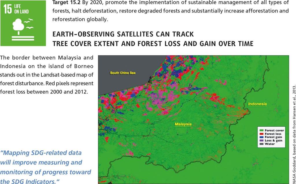
44 Indicator Forest area as a percentage of total land area Target 15.1 By 2020 ensure the conservation, restoration and sustainable use of terrestrial and inland freshwater ecosystems and their services, in particular forests, wetlands, mountains and drylands Forest Area from Earth-observing Environmental Satellites 2000 % tree cover % tree cover Tree Cover Credit: Matthew C. Hansen, Univ. Maryland, et al.

45 Indicator Forest area as a percentage of total land area Target 15.1 By 2020 ensure the conservation, restoration and sustainable use of terrestrial and inland freshwater ecosystems and their services, in particular forests, wetlands, mountains and drylands Gross Forest Cover Change: % tree cover Brazil Indonesia % 100% Annual forest loss, million ha Tree canopy cover Forest loss DRC << Annual loss shown using 3-year mean filter Credit: M. Hansen, UMd, et al.
46


47 Earth Observations and Geospatial Information Support to SDGs An analysis by GEO and CEOS has identified specific Targets and Indicators that can be supported by Earth observations, summarized in Figure
48 Free and open data is on the increase Some global initiatives are trying to offer free and open EO data, such as Radiant Earth (Bill Gates Foundation and ebay) The advent of the free and open data policy of Europe s Copernicus programme of multiple satellite data streams, the prospects for access to the EO data required by developing countries have improved considerably. Cloud storage and processing capabilities are making it simpler to handle and apply EO satellite datasets which can be large and complex. And space agencies are prioritizing efforts to further remove the burden on potential users by making more data analysis ready (analysis ready data or ARD).
49 IAEG-SDGs Working Group on Geospatial Information Provide expertise and advice as to how geospatial information, Earth observations and other new data sources can reliably and consistently contribute to the indicators. Review the agreed indicators and metadata through a geographic location lens and identify existing geospatial data gaps, methodological and measurements issues. Propose strategies for undertaking methodological work on specific areas for improving disaggregation by geographic location concepts.
50 Conclusions/Recommendations Recognition of the importance of Geospatial Information Technology SDG Indicators with a geographic dimension Geospatial Information Technology is a cross-cutting technology to help achieve SDGs. It is not a short-cut or panacea to development, but an enabler/accelerator to Development At global and regional levels: bring Statistical and Geospatial communities to work together: Develop the Global Statistical-Geospatial Framework (UN Statistical Commission & UN-GGIM) At national level: better cooperation/coordination between NSOs and NMAs: through the National Spatial Data Infrastructure (NSDI)
51 Conclusions Building a National Geospatial Information Infrastructure is as important as building roads, telecommunications, etc. Two major opportunities for countries: 2030 Sustainable Development Agenda (SDGs-recognition of the importance of the integration of statistical and geospatial information) and 2020 Round of Census (to develop their statistical-geospatial infrastructure) Role of Governments and all stakeholders (Partnerships) in Mobilizing Geospatial Information Technology for Sustainable Development.
52 Thank You!!
53 Three Tiers of indicators Tier I: established methodology and data available (Global reporting is currently based on Tier I and a few Tier II indicators, where regional aggregates are possible) Tier II: established methodology but data not regularly produced by countries (Capacity building efforts will focus on Tier II) Tier III: no established methodology and standards or being developed/tested (Methodological work is taking place on approximately one third of the indicators)
54 Geospatial and Earth Observations in Support of the Global Indicator Framework The IAEG-SDGs Working Group on Geospatial Information concluded that there are a number of indicators, including Tier I indicators, which would be much more relevant once disaggregated through geospatial information as required within the targets. Geospatial information and Earth observations are able to provide enabling methodologies and processes for disaggregation. In some cases, the disaggregation of national statistical data is only viable by use of geospatial information. This is acknowledged within the five guiding principles of the Global Statistical Geospatial Framework.
55 ape Town Global Action Plan for Sustainable Development Data Objective 3.4: Integrate geospatial data into statistical production programmes at all levels. Key Actions: Promote the integration of modern geospatial information management systems within mainstream statistical production programmes by highlighting synergies between the two systems. Promote the integration of geospatial and statistical metadata. Encourage the use and adoption of technologies that promote integration of geospatial and statistical information. Support the implementation of the Global Statistical and Geospatial Framework, when it is adopted.
Foundation Geospatial Information to serve National and Global Priorities
 Foundation Geospatial Information to serve National and Global Priorities Greg Scott Inter-Regional Advisor Global Geospatial Information Management United Nations Statistics Division UN-GGIM: A global
Disaster Management & Recovery Framework: The Surveyors Response
 Disaster Management & Recovery Framework: The Surveyors Response Greg Scott Inter-Regional Advisor Global Geospatial Information Management United Nations Statistics Division Department of Economic and
The Global Statistical Geospatial Framework and the Global Fundamental Geospatial Themes
 The Global Statistical Geospatial Framework and the Global Fundamental Geospatial Themes Sub-regional workshop on integration of administrative data, big data and geospatial information for the compilation
THE ROLE OF GEOSPATIAL AT THE WORLD BANK
 THE ROLE OF GEOSPATIAL AT THE WORLD BANK INSPIRE Conference Barcelona, Spain September 26, 2016 Kathrine Kelm Senior Land Administration Specialist Global Land and Geospatial Unit The World Bank Group
The Global Statistical Geospatial Framework. Martin Brady Director Geospatial Solutions Australian Bureau of Statistics Australia
 The Global Statistical Geospatial Framework Martin Brady Director Geospatial Solutions Australian Bureau of Statistics Australia Outline 1. Origins of the Global Statistical Geospatial Framework 2. Global
Integration for Informed Decision Making
 Geospatial and Statistics Policy Intervention: Integration for Informed Decision Making Greg Scott Global Geospatial Information Management United Nations Statistics Division Department of Economic and
8 th Meeting of IAEG-SDGs 5 8 November 2018, Stockholm, Sweden. Meetings. Report
 Meetings 8 th Meeting of IAEG-SDGs Between April 2018 and November 2018, the Working Group on Geospatial Information of the IAEG- SDGs held two online meetings; presented a report to the United Nations
Measuring Disaster Risk for Urban areas in Asia-Pacific
 Measuring Disaster Risk for Urban areas in Asia-Pacific Acknowledgement: Trevor Clifford, Intl Consultant 1 SDG 11 Make cities and human settlements inclusive, safe, resilient and sustainable 11.1: By
The UN-GGIM: Europe core data initiative to encourage Geographic information supporting Sustainable Development Goals Dominique Laurent, France
 INSPIRE conference Strasbourg 6 September 2017 The UN-GGIM: Europe core data initiative to encourage Geographic information supporting Sustainable Development Goals Dominique Laurent, France Introduction
Progress Report. Preamble
 Preamble This report is prepared and submitted to the Inter-agency and Expert Group on Sustainable Development Goal Indicators at its Fifth Meeting held from 28 31 March 2017 in Ottawa, Canada. Background
KUNMING FORUM ON UNITED NATIONS GLOBAL GEOSPATIAL INFORMATION MANAGEMENT CITIES OF THE FUTURE: SMART, RESILIENT
 KUNMING FORUM ON UNITED NATIONS GLOBAL GEOSPATIAL INFORMATION MANAGEMENT CITIES OF THE FUTURE: SMART, RESILIENT and SUSTAINABLE Yunnan Zhenzhuang Guest House, Kunming, China 10 12 May 2017 BACKGROUND CONCEPT
KENYA NATIONAL BUREAU OF STATISTICS Workshop on
 KENYA NATIONAL BUREAU OF STATISTICS Workshop on Capacity Building in Environment Statistics: the Framework for the Development of Environment Statistics (FDES 2013) Coordination with Sector Ministries
The Global Fundamental Geospatial Data Themes Journey. April Clare Hadley WG Chair
 The Global Fundamental Geospatial Data Themes Journey April 2018 Clare Hadley WG Chair The Road to here Why Global? Why Geospatial? Why Fundamental? Why Themes? The route we took Where does the road go
Geospatial Technologies for Resources Planning & Management
 Geospatial Technologies for Resources Planning & Management Lal Samarakoon, PhD Director, Geoinformatics Center Asian Institute of Technology, Thailand Content Geoinformatics for SDG Information Integration
GIS (GEOGRAPHICAL INFORMATION SYSTEMS) AS A FACILITATION TOOL FOR SUSTAINABLE DEVELOPMENT IN AFRICA
 AS A FACILITATION TOOL FOR SUSTAINABLE DEVELOPMENT IN AFRICA") GIS (GEOGRAPHICAL INFORMATION SYSTEMS) AS A FACILITATION TOOL FOR SUSTAINABLE DEVELOPMENT IN AFRICA a presentation by Elizabeth Hicken GDEST Conference on Geospatial Sciences for Sustainable Development
GIS (GEOGRAPHICAL INFORMATION SYSTEMS) AS A FACILITATION TOOL FOR SUSTAINABLE DEVELOPMENT IN AFRICA a presentation by Elizabeth Hicken GDEST Conference on Geospatial Sciences for Sustainable Development
Indicator : Average share of the built-up area of cities that is open space for public use for all, by sex, age and persons with disabilities
 Goal 11: Make cities and human settlements inclusive, safe, resilient and sustainable Target 11.7: By 2030, provide universal access to safe, inclusive and accessible, green and public spaces, in particular
Together towards a Sustainable Urban Agenda
 Together towards a Sustainable Urban Agenda The City We (Youth) Want Preliminary findings from youth consultations Areas Issue Papers Policy Units 1.Social Cohesion and Equity - Livable Cities 2.Urban
Fundamental Geospatial Datasets in Africa. Andre Nonguierma New York, 03 August 2015
 Fundamental Geospatial Datasets in Africa United Nations Economic Commission for Africa Geoinformation & Spatial Statistics Andre Nonguierma New York, 03 August 2015 Core Data : Lack of consistency Infrastructure
The Integrated Ge spatial Information Framework to the strengthening of NSDI, Mongolia
 Young Geospatial Professionals Summit 21 NOV 2018 The Integrated Ge spatial Information Framework to the strengthening of NSDI, Mongolia BAYARMAA ENKHTUR Geospatial information and technology department
UN GGIM and National SDI Strategy
 MSDI Open Forum on 26 th January 2016 Contributing to the successful delivery of MSDI UN GGIM and National SDI Strategy Hiroshi Murakami Deputy Administrator Geospatial Information Authority of Japan Geospatial
Geospatial Information and Services for Disasters (GIS4D)
") Geospatial Information and Services for Disasters (GIS4D) 31 July 2017 Tae Hyung KIM ICT and Disaster Risk Reduction Division (IDD) UNESCAP 1 About ESCAP Who is ESCAP? United Nations Economic and Social
Geospatial Information and Services for Disasters (GIS4D) 31 July 2017 Tae Hyung KIM ICT and Disaster Risk Reduction Division (IDD) UNESCAP 1 About ESCAP Who is ESCAP? United Nations Economic and Social
WORLD COUNCIL ON CITY DATA
 WORLD COUNCIL ON CITY DATA WCCD ISO 37120 STANDARDIZED CITY DATA TO MEET UN SDG TARGETS UN WORLD DATA FORUM Presented by: James Patava www.dataforcities.org @wccitydata PUBLICATION OF THE FIRST ISO STANDARD
International Guidelines on Access to Basic Services for All
 International Guidelines on Access to Basic Services for All Presentation and initials lessons from implementation Accessibility to services in regions and cities : measures and policies, OECD 18 June
ENV208/ENV508 Applied GIS. Week 1: What is GIS?
 ENV208/ENV508 Applied GIS Week 1: What is GIS? 1 WHAT IS GIS? A GIS integrates hardware, software, and data for capturing, managing, analyzing, and displaying all forms of geographically referenced information.
Geospatial Information Management in the Americas: Lessons for the Post-2015 development agenda
 Geospatial Information Management in the Americas: Lessons for the Post-2015 development agenda Rolando Ocampo President, UN-GGIM: Americas October 2014 The integration of statistical and geographical
Bengt Kjellson Chair of the Executive Committee UN-GGIM: Europe. 2 nd Joint UN-GGIM: Europe ESS Meeting 11 th March 2016, Luxembourg
 Bengt Kjellson Chair of the Executive Committee UN-GGIM: Europe 2 nd Joint UN-GGIM: Europe ESS Meeting 11 th March 2016, Luxembourg A global geospatial mandate At its 47th plenary in July 2011, ECOSOC,
GEOGRAPHIC INFORMATION SYSTEMS Session 8
 GEOGRAPHIC INFORMATION SYSTEMS Session 8 Introduction Geography underpins all activities associated with a census Census geography is essential to plan and manage fieldwork as well as to report results
Geographical Names: Relevance and place within the UN-GGIM framework
 Geographical Names: Relevance and place within the UN-GGIM framework Greg Scott Inter-Regional Advisor Global Geospatial Information Management United Nations Statistics Division UN-GGIM: A global initiative
Geospatial workflows and potential applications to the Sustainable Development Goals of countries in West Asia
 Geospatial workflows and potential applications to the Sustainable Development Goals of countries in West Asia Ameer Abdulla, PhD Senior Advisor, European Topic Center for Spatial Analysis, Spain Associate
Prof Chryssy Potsiou, FIG President
 THE VALUE OF GEOSPATIAL DATA AND ROLE OF SURVEYORS IN SUSTAINABLE DEVELOPMENT Prof Chryssy Potsiou, FIG President National Technical University of Athens School of Rural and Surveying Engineering, Greece
Achieving the Vision Geo-statistical integration addressing South Africa s Developmental Agenda. geospatial + statistics. The Data Revolution
 Achieving the Vision Geo-statistical integration addressing South Africa s Developmental Agenda geospatial + statistics The Data Revolution humble beginnings, present & future - South Africa UN World Data
1) United Nations Committee of Experts on Global Geospatial Information Management (UN-GGIM)
 United Nations Committee of Experts on Global Geospatial Information Management (UN-GGIM)") International Workshop on Legal and Policy Frameworks for Geospatial Information Management Licensing of Geospatial Information 7 9 November 2017 Tianjin Zhengxie Club Hotel Tianjin, China Outline of presentation
International Workshop on Legal and Policy Frameworks for Geospatial Information Management Licensing of Geospatial Information 7 9 November 2017 Tianjin Zhengxie Club Hotel Tianjin, China Outline of presentation
2018/1 The integration of statistical and geospatial information. The Regional Committee of UN-GGIM: Americas:
 The following are the conclusions and recommendations of the Regional Committee of the United Nations on Global Geospatial Information Management for the Americas, during its Fifth Session, Thursday 8
Advancing Geoscientific Capability. Geological Survey of Finland
 Advancing Geoscientific Capability Geological Survey of Finland GTK in brief The Geological Survey of Finland (GTK) is one of the largest European centres of excellence in assessment, research and the
Economic and Social Council
 United Nations Economic and Social Council Distr.: General 2 July 2012 E/C.20/2012/10/Add.1 Original: English Committee of Experts on Global Geospatial Information Management Second session New York, 13-15
Space for Sustainable Development
 Space for Sustainable Development ESA s contribution to the Where, What, and How of Data Dr. Christoph Aubrecht Directorate of Earth Observation Programmes Science, Applications and Future Technologies
UN-GGIM: Strengthening Geospatial Capability
 Fifth Plenary Meeting of UN-GGIM: Europe Brussels, 6-7 June 2018 UN-GGIM: Strengthening Geospatial Capability Walking the talk to leave no one behind Greg Scott, UN-GGIM Secretariat Environmental Statistics
Economic and Social Council
 United Nations Economic and Social Council Distr.: General 18 July 2016 Original: English Committee of Experts on Global Geospatial Information Management Sixth session New York, 3-5 August 2016 Item 2
SDG s and the role of Earth Observation
 SDG s and the role of Earth Observation Christian Heipke IPI - Institute for Photogrammetry and GeoInformation Leibniz Universität Hannover Germany Secretary General, ISPRS 1. No Poverty 2. Zero Hunger
EuroGEOSS Protected Areas Pilot
 EuroGEOSS Protected Areas Pilot Max Craglia European Commission Joint Research Centre Part 1: the present MyNatura2000 Mobile app. Awareness raising & volunteered data collection. Natura2000 covers 18%
Experience of Mexico in using GIS and spatial
 Experience of Mexico in using GIS and spatial data as a tool for data integration Francisco Javier Jimenez Nava Deputy General Director of Natural Resources and Environment Outline Introduction National
Implementing the Sustainable Development Goals: The Role of Geospatial Technology and Innovation
 Fifth High Level Forum on UN Global Geospatial Information Management Implementing the Sustainable Development Goals: The Role of Geospatial Technology and Innovation 28-30 November 2017 Sheraton Maria
SDI Development in Georgia. Mari Khardziani Head of International Relations Unit National Agency of Public Registry
 SDI Development in Georgia Mari Khardziani Head of International Relations Unit National Agency of Public Registry Kehl, Germany September 5, 2017 2 National Agency of Public Registry Legal Entity of Public
Basic Act on the Advancement of Utilizing Geospatial Information
 Basic Act on the Advancement of Utilizing Geospatial Information (Act No. 63 of May 30, 2007) Table of Contents Chapter I General Provisions (Articles 1 to 8) Chapter II Basic Plan for the Advancement
Challenges and Successes in Sharing Geospatial Data in Africa
 Challenges and Successes in Sharing Geospatial Data in Africa 2018 GeoNode Summit Torino, Italy March 26-28, 2018 Bernard Justus Muhwezi Manager, Geo-Information Services Uganda Bureau of Statistics, Kampala,
IAEG SDGs WG GI, , Mexico City
 IAEG SDGs WG GI, 12-14.12.2016, Mexico City UN-GGIM:Europe s perspective and activities to support better integration of geospatial information and statistics and the UN SDG monitoring Pier-Giorgio Zaccheddu,
Globally Estimating the Population Characteristics of Small Geographic Areas. Tom Fitzwater
 Globally Estimating the Population Characteristics of Small Geographic Areas Tom Fitzwater U.S. Census Bureau Population Division What we know 2 Where do people live? Difficult to measure and quantify.
Dr. Biliana Cicin-Sain President, Global Ocean Forum 1
 Towards a Sustainable Development Goal on Oceans and Seas: Healthy, Productive and Resilient Oceans and Seas- Prosperous and Resilient Peoples and Communities Dr. Biliana Cicin-Sain President, Global Ocean
Principle 3: Common geographies for dissemination of statistics Poland & Canada. Janusz Dygaszewicz Statistics Poland
 Principle 3: Common geographies for dissemination of statistics Poland & Canada Janusz Dygaszewicz Statistics Poland Reference materials Primary: Ortophotomap, Cadastral Data, Administrative division borders,
INDONESIA S S UPDATE: GEOSPATIAL INFORMATION FOR SUSTAINABLE DEVELOPMENT RELATED TO INA SDI Dr. Asep Karsidi, M.Sc
 INDONESIA S S UPDATE: GEOSPATIAL INFORMATION FOR SUSTAINABLE DEVELOPMENT RELATED TO INA SDI Dr. Asep Karsidi, M.Sc GEOSPATIAL INFORMATION AGENCY 08 August, 2012 OUTLINE 1. Transformation Bakosurtanal into
Spanish national plan for land observation: new collaborative production system in Europe
 ADVANCE UNEDITED VERSION UNITED NATIONS E/CONF.103/5/Add.1 Economic and Social Affairs 9 July 2013 Tenth United Nations Regional Cartographic Conference for the Americas New York, 19-23, August 2013 Item
Land Accounts - The Canadian Experience
 Land Accounts - The Canadian Experience Development of a Geospatial database to measure the effect of human activity on the environment Who is doing Land Accounts Statistics Canada (national) Component
National assessment on member s readiness to produce indicators
 Inter-Agency and Expert Group on the Sustainable Development Goal Indicators WORKING GROUP ON GEOSPATIAL INFORMATION Fifth expert meeting 5 and 8 December 2018 8 th Meeting of IAEG-SDGs 5 8 November 2018,
Use of registers in statistical geospatial integration
 Use of registers in statistical geospatial integration Trevor Sutton Deputy Australian Statistician Statistical Business Transformation Australian Bureau of Statistics March 2016 Role of registers in the
Understanding China Census Data with GIS By Shuming Bao and Susan Haynie China Data Center, University of Michigan
 Understanding China Census Data with GIS By Shuming Bao and Susan Haynie China Data Center, University of Michigan The Census data for China provides comprehensive demographic and business information
A Presenta*on to the Interna*onal Workshop on Global Fundamental Geospa*al Data Themes for Africa By Sultan Mohammed Alya Chairman of UN-GGIM: Africa
 A Presenta*on to the Interna*onal Workshop on Global Fundamental Geospa*al Data Themes for Africa By Sultan Mohammed Alya Chairman of UN-GGIM: Africa Execu*ve Bureau and Director General of Ethiopian Geospa*al
Disaggregation according to geographic location the need and the challenges
 International Seminar On United Nations Global Geospatial Information Management Disaggregation according to geographic location the need and the challenges 6 th 7 th November 2018 Tribe Hotel, Nairobi,
Brazil Paper for the. Second Preparatory Meeting of the Proposed United Nations Committee of Experts on Global Geographic Information Management
 Brazil Paper for the Second Preparatory Meeting of the Proposed United Nations Committee of Experts on Global Geographic Information Management on Data Integration Introduction The quick development of
Climate Resilience Decision Making Framework in the Caribbean. A case of Spatial Data Management
 Climate Resilience Decision Making Framework in the Caribbean A case of Spatial Data Management Bishwa Pandey Sr. Data Management Specialist The World Bank Background The mission of The World Bank s Latin
Georeferencing and Satellite Image Support: Lessons learned, Challenges and Opportunities
 Georeferencing and Satellite Image Support: Lessons learned, Challenges and Opportunities Shirish Ravan shirish.ravan@unoosa.org UN-SPIDER United Nations Office for Outer Space Affairs (UNOOSA) UN-SPIDER
The Combination of Geospatial Data with Statistical Data for SDG Indicators
 Session 3: Sustainable Development Goals, SDG indicators The Combination of Geospatial Data with Statistical Data for SDG Indicators Pier-Giorgio Zaccheddu (with the assistance of Francisco Vala & Cátia
Improving rural statistics. Defining rural territories and key indicators of rural development
 Improving rural statistics Defining rural territories and key indicators of rural development Improving rural statistics Improving Rural Statistics In 2016, the Global Strategy to improve Agricultural
THE SEVILLE STRATEGY ON BIOSPHERE RESERVES
 THE SEVILLE STRATEGY ON BIOSPHERE RESERVES 1 VISION FOR BIOSPHERE RESERVES IN THE 21 ST CENTURY The international Seville Conference on Biosphere Reserves, organised by UNESCO, adopted a two-pronged approach,
Space Application in Support of Land Management for SDG Implementation
 Space Application in Support of Land Management for SDG Implementation Regional Expert Workshop on Land Accounting for SDG Monitoring and Reporting 26 September 2017 Space Application Section Information
Seabed knowledge In support of UN SDGs
 Seabed knowledge In support of UN SDGs Evert Flier Fiskerifaglig forum 2. november 2017 Hydrography & small scale fishing Hydrography in Transition Serving the Maritime Community Hydrography in Transition
Land Accounting. Sub-regional Workshop on Environment Statistics for South and South-West Asian Countries. Michael Bordt ESCAP
 Land Accounting Michael Bordt ESCAP bordt@un.org Sub-regional Workshop on Environment Statistics for South and South-West Asian Countries Feb. 6-8, 2017 Bangkok, Thailand Overview: Land Accounting Learning
International Workshop on Legal and Policy Frameworks for Geospatial Information Management: Licensing of Geospatial Information
 United Nations Committee of Experts on Global Geospatial Information Management International Workshop on Legal and Policy Frameworks for Geospatial Information Management: Licensing of Geospatial Information
Qatar Statistical Geospatial Integration
 Qatar Statistical Geospatial Integration A Presentation by the Ministry of Development Planning & Statistics (MDPS), State of Qatar http://www.mdps.gov.qa (Fourth UN-GGIM Arab States Committee Meeting,
Common geographies for dissemination of SDG Indicators
 5 th High Level Forum on United Nations GGIM, Mexico 2017 Common geographies for dissemination of SDG Indicators Understanding statistical and geodetic division of territory Janusz Dygaszewicz Central
Integration of Geo spatial and Statistical Information: The Nepelese Experience
 Integration of Geo spatial and Statistical Information: The Nepelese Experience Krishna Raj B.C. Joint Secretary Ministry of Land Reform and Management, Nepal 11 June, 2014 Presentation Outline The Country
The Combination of Geospatial Data with Statistical Data for SDG Indicators
 Session x: Sustainable Development Goals, SDG indicators The Combination of Geospatial Data with Statistical Data for SDG Indicators Pier-Giorgio Zaccheddu Fabio Volpe 5-8 December2018, Nairobi IAEG SDG
Welcome. C o n n e c t i n g
 Welcome C o n n e c t i n g YOU D i s c i p l i n e s Why is This Meeting......So Important Now? OUR WORLD Is Increasingly Challenged The Evidence Is Clear We Need Better Understanding and More Collaboration
Geospatial activities during the 47 th UN Statistical Commission
 Geospatial activities during the 47 th UN Statistical Commission A Summary Rolando Ocampo Alcántar April 2016 47 th Session of the United Nations Statistical Commission Side Events Friday Seminar on Emerging
Overview of proposed approach to the Desktop Study to inform discussion
 LTAS Phase 2: Climate Change Implications for the Human Settlements sector in South Africa Overview of proposed approach to the Desktop Study to inform discussion Project Team Project Lead: Crispian Olver
Egypt Public DSS. the right of access to information. Mohamed Ramadan, Ph.D. [R&D Advisor to the president of CAPMAS]
![Egypt Public DSS. the right of access to information. Mohamed Ramadan, Ph.D. [R&D Advisor to the president of CAPMAS]](/thumbs/89/98483713.jpg "Egypt Public DSS. the right of access to information. Mohamed Ramadan, Ph.D. [R&D Advisor to the president of CAPMAS]") Egypt Public DSS ì the right of access to information Central Agency for Public Mobilization and Statistics Arab Republic of Egypt Mohamed Ramadan, Ph.D. [R&D Advisor to the president of CAPMAS] Egypt
Egypt Public DSS ì the right of access to information Central Agency for Public Mobilization and Statistics Arab Republic of Egypt Mohamed Ramadan, Ph.D. [R&D Advisor to the president of CAPMAS] Egypt
CONFERENCE STATEMENT
 CONFERENCE STATEMENT We, the elected representatives from Canada, Denmark/Greenland, Finland, Iceland, Norway, Russia, Sweden and the United States of America; In collaboration with the indigenous peoples
Module 3 Indicator Land Consumption Rate to Population Growth Rate
 Regional Training Workshop on Human Settlement Indicators Module 3 Indicator 11.3.1 Land Consumption Rate to Population Growth Rate Dennis Mwaniki Global Urban Observatory, Research and Capacity Development
Topic 4: Changing cities
 Topic 4: Changing cities Overview of urban patterns and processes 4.1 Urbanisation is a global process a. Contrasting trends in urbanisation over the last 50 years in different parts of the world (developed,
INSPIRE Basics. Vlado Cetl European Commission Joint Research Centre. https://ec.europa.eu/jrc/
 INSPIRE Basics Vlado Cetl European Commission Joint Research Centre https://ec.europa.eu/jrc/ Serving society Stimulating innovation Supporting legislation Outline SDI? Why European SDI? INSPIRE Policy
Work Group A «Core Data» Report and Update François Chirié, Dominique Laurent, France
 JOINT UN-GGIM: EUROPE ESS MEETING ON THE INTEGRATION OF STATISTICAL AND GEOSPATIAL INFORMATION LUXEMBOURG 11 MARCH 2016 Work Group A «Core Data» Report and Update François Chirié, Dominique Laurent, France
GEOMATICS. Shaping our world. A company of
 GEOMATICS Shaping our world A company of OUR EXPERTISE Geomatics Geomatics plays a mayor role in hydropower, land and water resources, urban development, transport & mobility, renewable energy, and infrastructure
Sustainable tourism in for Sustaibale Danang
 Sustainable tourism in for Sustaibale Danang A case study of Balearic Ecotax in Spain toward Sustainable tourism Miki Yoshizumi Associate Professor College of Gastronomy Management Ritsumeikan University
Presented to Sub-regional workshop on integration of administrative data, big data and geospatial information for the compilation of SDG indicators
 Presented to Sub-regional workshop on integration of administrative data, big data and geospatial information for the compilation of SDG indicators 23-25 April,2018 Addis Ababa, Ethiopia By: Deogratius
THE GLOBAL INDICATOR FRAMEWORK: NEW AND INNOVATIVE METHODS FOR DISAGGREGATIN BY GEOLOCATION
 Parallel Session: Measuring and Monitoring the SDGs: THE GLOBAL INDICATOR FRAMEWORK: NEW AND INNOVATIVE METHODS FOR DISAGGREGATIN BY GEOLOCATION from global to regional to national panorama 8 th Meeting
Report on the establishment of UN GGIM: Europe Item 14. 4th session of the Committee of Experts on UN-GGIM
 Report on the establishment of UN GGIM: Europe Item 14 1 Why regional European committees of UN GGIM? In the ECOSOC resolution 2011/24 on the UN GGIM: Emphasizes the importance of promoting national, regional
Empowered lives. Resilient nations. Data for People and Planet. powered by
 Empowered lives. Resilient nations. Data for People and Planet powered by Overview As we enter the fourth industrial revolution, technology is revolutionizing our ability to map nature. Satellite data
Key Indicators for Territorial Cohesion & Spatial Planning Stakeholder Workshop - Project Update. 13 th December 2012 San Sebastián, Basque Country
 Key Indicators for Territorial Cohesion & Spatial Planning Stakeholder Workshop - Project Update 13 th December 2012 San Sebastián, Basque Country Key Aims Explore the use of territorial data in developing
UN-GGIM: An Overview Stefan Schweinfest, Director (UNSD) Bangkok, 27 March 2015
 Bangkok, 27 March 2015") UN-GGIM: An Overview Stefan Schweinfest, Director (UNSD) Bangkok, 27 March 2015 ggim.un.org UN-GGIM: A global initiative Formal inter-governmental UN Committee of Experts to: Discuss, enhance and coordinate
UN-GGIM: An Overview Stefan Schweinfest, Director (UNSD) Bangkok, 27 March 2015 ggim.un.org UN-GGIM: A global initiative Formal inter-governmental UN Committee of Experts to: Discuss, enhance and coordinate
MALDIVES. Regional Expert Workshop On Land Accounting For SDG Monitoring & Reporting (25-27 th Sept 2017) - Fathimath Shanna, Aishath Aniya -
 - Fathimath Shanna, Aishath Aniya -") MALDIVES Regional Expert Workshop On Land Accounting For SDG Monitoring & Reporting (25-27 th Sept 2017) - Fathimath Shanna, Aishath Aniya - ABOUT MALDIVES Approximately 860 km long and 120 km wide Consists
MALDIVES Regional Expert Workshop On Land Accounting For SDG Monitoring & Reporting (25-27 th Sept 2017) - Fathimath Shanna, Aishath Aniya - ABOUT MALDIVES Approximately 860 km long and 120 km wide Consists
Indicator: Proportion of the rural population who live within 2 km of an all-season road
 Goal: 9 Build resilient infrastructure, promote inclusive and sustainable industrialization and foster innovation Target: 9.1 Develop quality, reliable, sustainable and resilient infrastructure, including
Geospatial framework for monitoring SDGs/Sendai targets By Shimonti Paul Sr. Assistant Editor Geospatial Media & Communications
 Geospatial framework for monitoring SDGs/Sendai targets By Shimonti Paul Sr. Assistant Editor Geospatial Media & Communications Outline 1. Introduction to Geospatial Media and Communications 2. Geospatial
ReCAP Status Review of the Updated Rural Access Index (RAI) Stephen Vincent, Principal Investigator
 Stephen Vincent, Principal Investigator") ReCAP Status Review of the Updated Rural Access Index (RAI) Stephen Vincent, Principal Investigator Establishment of RAI in 2005/2006 2006 Definition of the RAI Note by Peter Roberts Dated September 2005
ReCAP Status Review of the Updated Rural Access Index (RAI) Stephen Vincent, Principal Investigator Establishment of RAI in 2005/2006 2006 Definition of the RAI Note by Peter Roberts Dated September 2005
LandScan Global Population Database
 LandScan Global Population Database The World s Finest Population Distribution Data Uncommon information. Extraordinary places. LandScan Global Population Database East View Cartographic is now offering
Geospatial Enabling Resilient Development. Latin America Geospatial Forum Río de Janeiro September 2013
 Geospatial Enabling Resilient Development Latin America Geospatial Forum Río de Janeiro September 2013 Presentation Index INEGI /SNIEG Geostatistical Frame - Georeferenciation Issues Legal Framework Mexican
A/AC.105/C.1/2012/CRP.10
 A/AC.105/C.1/2012/CRP.10 1 February 2012 English only Committee on the Peaceful Uses of Outer Space Scientific and Technical Subcommittee Forty-ninth session Vienna, 6-17 February 2012 Item 6 of the provisional
Copernicus Overview. Major Emergency Management Conference Athlone 2017
 Copernicus Overview Major Emergency Management Conference Athlone 2017 Copernicus is a European programme implemented by the European Commission. The services address six thematic areas: land, marine,
Second Administrative Level Boundaries (SALB) initiative & geographic names in cartography. Geospatial Information Section
 initiative & geographic names in cartography. Geospatial Information Section") Second Administrative Level Boundaries (SALB) initiative & geographic names in cartography Geospatial Information Section Introduction Goals Global agenda How does SALB work? Latest News on geographic
Second Administrative Level Boundaries (SALB) initiative & geographic names in cartography Geospatial Information Section Introduction Goals Global agenda How does SALB work? Latest News on geographic
Use of Geospatial data for disaster managements
 Use of Geospatial data for disaster managements Source: http://alertsystemsgroup.com Instructor : Professor Dr. Yuji Murayama Teaching Assistant : Manjula Ranagalage What is GIS? A powerful set of tools
Geospatial and Statistical Data Integration
 Geospatial and Statistical Data Integration Dr. Emmanuel Nkurunziza Director General Outline I. About RCMRD II. Evolution of Rwanda s geospatial and statistics systems III. Statistics in Rwanda IV. Geospatial
Supporting GPSC Cities with Satellite Earth Observation for Sustainable Urban Development
 Supporting GPSC Cities with Satellite Earth Observation for Sustainable Urban Development Global Platform for Sustainable Cities African Regional Workshop 14 May 2018 AfDB Headquarters Abidjan, Côte d'ivoire