You need Geography Alive Textbook Calculator Warm Up Do you like crowded places or do you prefer places where there are fewer people? (ex.
|
|
|
- Sheila Tate
- 5 years ago
- Views:
Transcription


1 You need Geography Alive Textbook Calculator Warm Up Do you like crowded places or do you prefer places where there are fewer people? (ex. parties, shopping, etc.) Why?


2 Turn to Page 445 and define Arable Land Geo Terms Arithmetic Population Density Physiologic Population Density Population Distribution
3
4 Australia Total Land Area Population ARITHMETIC population density (people per sq. mile) Percentage of Arable Land Arable Land Area (per sq. mile) PHYSIOLOGICAL population Density (people per sq. mile) 2,941,283 19,913, % 192,
5
6 United States Total Land Area Population ARITHMETIC population density (people per sq. mile) Percentage of Arable Land Arable Land Area (per sq. mile) PHYSIOLOGICAL population Density (people per sq. mile) 3,537, ,027, % 676,

7
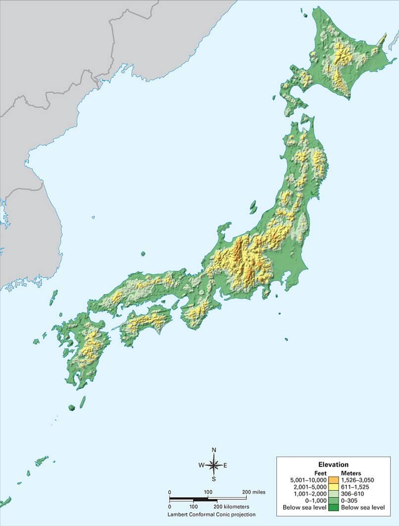
8 Japan Total Land Area Population ARITHMETIC population density (people per sq. mile) Percentage of Arable Land Arable Land Area (per sq. mile) PHYSIOLOGICAL population Density (people per sq. mile) 144, ,333, % 17,638 7,219

9
10 Population Density in Japan: Life in a Crowded Country

11
12 Background Information: A. Japan occupies an archipelago, or chain of islands - 4 large islands and 3,900 smaller islands B. Japan enjoys a temperate climate - Heavy snowfall is limited to high elevations & the far north
13
14 C. A chain of volcanic mountains forms the backbone of Japan - Mt. Fuji towers over Tokyo, the world s most populous city D. Continued plate movement leads to frequent tremors - Undersea earthquakes can trigger tsunamis


15
16 E. Only about 1/8 of Japan is arable land. The rest is too steep. - About 80% of the population lives on limited flat land near the coast.

17
18 How population density affects transportation.
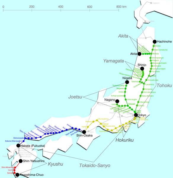
19 A. Public transportation - The average commute time in Tokyo is an hour and a half each day - The Japanese have developed an efficient public transit system - Crowded underground subways - Bullet trains travel between cities at up to 180 mph

20

21
22

23
24 B. Private cars and parking problems - Car ownership has increased, so traffic congestion is a part of daily life - Residents of Tokyo cannot own a car unless they can prove they have a place to park it - The use of computer-controlled parking lots has developed, stacking cars in narrow slots

25
26 How population density affects housing.
27 A. From the country to the city - Because flat land for building is scarce, housing can be expensive. - Most homes in Japan are far smaller than those in the U.S. - Extended families used to live together in rural areas - Education & jobs = urbanization
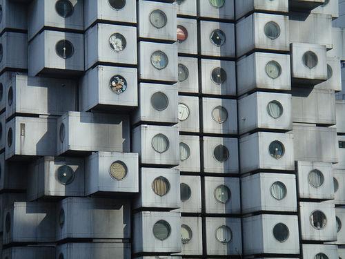
28 B. Making the most of limited space - The Japanese have developed clever ways to use space wisely - Many homes don t have separate bedrooms, only futons - Household appliances shrunk - Capsule hotels - Cremation instead of burial

29
30
31 How population density affects land use.
32 A. Building up and down - The Japanese have found better ways to use the land that is available - Skyscrapers use earthquakeresistant construction techniques in order to build higher - Underground shopping centers, restaurants, parks, museums, and even a zoo
33 B. Creating new land - New land has been created by filling in shallow wetlands with dirt - Destroys coastal wildlife habitats & can be unstable to earthquakes - Cut rice terraces into hillsides - Floating airport?

34

35

36
37 How population density affects health.
38 A. Pollution problems - Japan s crowded cities have created pollution issues - Limited space for garbage, sewage, & waste-water disposal - Emissions from factories & cars - Despite these problems, Japan mostly remains extremely clean
39 B. Long lives - The Japanese enjoy one of the highest life expectancies in the world - Sick people often wear face masks to avoid spreading the disease - Japan has some of the strictest environmental laws in the world

40
41 Homework Population Density Around our area Fill out the Chart posted online under homework for Friday to figure out the different population densities in our area.
42 Population Density Around our area New Territory Four Corners Pecan Grove AHS Total Land Area 5.1square miles 2.8 square miles 8.8 sq miles 309,608 square ft. Population 13,861 2,954 13,551 2,215 ARITHMETIC population density (people per sq. mile) 2,717.8 /sq mi 1,055 /sq mi 1,539.9 /sq mi 199,549.5 /sq mi
PREVIEW 31. Fact 2: Fact 3: Hokkaido. Fact 4: Fact 5:
 1. Examine the map of Japan your teacher has projected. With a partner, list five facts about Japan that can be determined from the map. Fact 1: PREVIEW 31 Fact 2: Fact 3: Hokkaido Fact 4: Fact 5: 2. Fill
Most people used to live like this
 Urbanization Most people used to live like this Increasingly people live like this. For the first time in history, there are now more urban residents than rural residents. Land Cover & Land Use Land cover
Physical Geography of East Asia
 Physical Geography of East Asia Satellite View of China Landforms of China China s Geography China Miles 0 250 500 1,000 1,500 2,000 United States 3 rd largest country in the world. Comparable to the US
Suggested volcano pattern in relation to the earthquake pattern and topography Learning Segment 7.1
 Teacher questions to prompt student observations of patterns : Describe the earthquake pattern. (Learning Segment 5.6) Describe the volcano pattern. (Learning Segment 6.5) Describe the volcano pattern
Unit 1, Lesson 3 What Tools and Technologies Do Geographers Use?
 Unit 1, Lesson 3 What Tools and Technologies Do Geographers Use? Geographers use a variety of tools and technologies in investigating geographic questions. Maps and globes both represent the earth, but
Changes to Land 5.7B. landforms: features on the surface of Earth such as mountains, hills, dunes, oceans and rivers
 All the landforms on Earth have changed over time and continue to change. Many of the changes were caused by wind, moving water, and moving ice. Mountains have grown and shrunk. Rivers have cut away land
Think about the landforms where you live. How do you think they have changed over time? How do you think they will change in the future?
 reflect All the landforms on Earth have changed over time and continue to change. Many of the changes were caused by wind, moving water, and moving ice. Mountains have grown and shrunk. Rivers have cut
Unit 1, Lesson 2. What is geographic inquiry?
 What is geographic inquiry? Unit 1, Lesson 2 Understanding the way in which social scientists investigate problems will help you conduct your own investigations about problems or issues facing your community
Urban Planning Word Search Level 1
 Urban Planning Word Search Level 1 B C P U E C O S Y S T E M P A R E U O E U R B A N P L A N N E R T N S T D H E C O U N T Y G E R E R D W R E N I C I T Y C O U N C I L A A A S U G G C I L A G P R I R
HOW GEOGRAPHY AND GEOLOGY AFFECT BIOLOGICAL DIVERSITY
 HOW GEOGRAPHY AND GEOLOGY AFFECT BIOLOGICAL DIVERSITY Factors Affecting Extinction Rates Natural Factors Climate change Cataclysmic event (volcano, earthquake) Human Activities Habitat Loss/Fragmentation
The Five Themes of Geography
 The Five Themes of Geography The Five Themes of Geography Main Idea: Geographers use the Five Themes of Geography to help them study the Earth. The Five Themes of Geography Geography and You: Suppose a
MULTIPLE CHOICE. Choose the one alternative that best completes the statement or answers the question.
 AP Test 13 Review Name MULTIPLE CHOICE. Choose the one alternative that best completes the statement or answers the question. 1) Compared to the United States, poor families in European cities are more
Paper Reference. Paper Reference(s) 1312/2F Edexcel GCSE Geography A Foundation Tier. Monday 11 June 2007 Afternoon Time: 1 hour 15 minutes
 1312/2F Edexcel GCSE Geography A Foundation Tier. Monday 11 June 2007 Afternoon Time: 1 hour 15 minutes") Centre No. Paper Reference Surname Initial(s) Candidate No. 1 3 1 2 2 F Signature Paper Reference(s) 1312/2F Edexcel GCSE Geography A Foundation Tier Paper 2F Monday 11 June 2007 Afternoon Time: 1 hour
Centre No. Paper Reference Surname Initial(s) Candidate No. 1 3 1 2 2 F Signature Paper Reference(s) 1312/2F Edexcel GCSE Geography A Foundation Tier Paper 2F Monday 11 June 2007 Afternoon Time: 1 hour
Cambridge International Examinations Cambridge International Advanced Subsidiary Level
 Cambridge International Examinations Cambridge International Advanced Subsidiary Level *9524768218* ENVIRONMENTAL MANAGEMENT 8291/12 Paper 1 Lithosphere and Atmosphere October/November 2015 Additional
Population And Settlement Part I
 Population And Settlement Part I 0011 0010 1010 1101 0001 0100 1011 4 12 Think of the earth as a living organism that is being attacked by billions of bacteria whose numbers double every forty years. Either
The Impact of Geography in South and East Asia
 The Impact of Geography in South and East Asia Gobi desert, Mongolia Essential Question: How does the geography of SE Asia impact trade and the distribution of population throughout the region? (AKS #52a)
The Impact of Geography in South and East Asia
 The Impact of Geography in South and East Asia Gobi desert, Mongolia Essential Question: How does geography impact the distribution of population throughout South and East Asia? I CAN Explain how geography
Lesson 8. Natural Disasters
 Lesson 8 Natural Disasters 1 Reading is NOT a spectator sport! 2 Reading requires active participation! 3 PREDICT Try to figure out what information will come next and how the selection might end. 4 Natural
(version 3) I. HumAN -Environment Interaction
 I. HumAN -Environment Interaction") (version 3) I. HumAN -Environment Interaction A. Landforms 1. Earth s topography is made up of many different types of landforms. 2. While the planet is covered primarily with water, the four major types
(version 3) I. HumAN -Environment Interaction A. Landforms 1. Earth s topography is made up of many different types of landforms. 2. While the planet is covered primarily with water, the four major types
Population Density and Services In this lesson, students broaden their understanding of the ways water, landforms, vegetation, Lesson 4
 Lesson 4 Houses in San Diego Population Density and Services In this lesson, students broaden their understanding of the ways water, landforms, vegetation, and climate affect where people live and what
Chapter 21 Southwest Asia: Harsh & Arid Lands
 Name Hour Chapter 21 Southwest Asia: Harsh & Arid Lands Essential Question: How has the physical geography of Asia influenced the development of these regions (i.e. history, population distribution, &
Introduction to Environmental Geology, 5e Case History: Indonesian Tsunami Indonesian Tsunami (2) Introduction Historic Tsunamis
 Introduction Historic Tsunamis") 1 2 3 4 5 6 7 8 9 Introduction to Environmental Geology, 5e Chapter 7 Tsunami Case History: Indonesian Tsunami December 26, 2004, within a few hours, close to 250,000 people were killed With no warning
1 2 3 4 5 6 7 8 9 Introduction to Environmental Geology, 5e Chapter 7 Tsunami Case History: Indonesian Tsunami December 26, 2004, within a few hours, close to 250,000 people were killed With no warning
World Geography Mid Term Review 2016
 World Geography Mid Term Review 2016 1.Latitude and Longitude Lines of latitude run and. The zero-degree line is the. Line of longitude run and. The zero degree line is called the. 2. Map Projections What
YEAR 7 GEOGRAPHY KNOWLEDGE BOOK
 YEAR 7 GEOGRAPHY KNOWLEDGE BOOK 1 P a g e WEATHER & CLIMATE The information here is what all students MUST know. Use this sheet as a checklist to identify what is clear to you, what you need to work on,
By Geri Flanary To accompany AP Human Geography: A Study Guide 3 rd edition By Ethel Wood
 Session 1 By Geri Flanary To accompany AP Human Geography: A Study Guide 3 rd edition By Ethel Wood WHAT IS DEMOGRAPHY? It is the scientific or statistical study of population. It comes from the Greek
The Variety of Maps By ReadWorks
 The Variety of Maps By ReadWorks Maps are known for helping us figure out how to get to a certain location: which road do I take to the ice-cream parlor? How do I get from my house to my best friend s?
Population Density. Population density: A measure of how crowded a place is.
 Population Density Population density: A measure of how crowded a place is. Formula: Population Density = Population Total Area km 2 Overall Canada has a low population density of about 3 people per km
Travel behavior of low-income residents: Studying two contrasting locations in the city of Chennai, India
 Travel behavior of low-income residents: Studying two contrasting locations in the city of Chennai, India Sumeeta Srinivasan Peter Rogers TRB Annual Meet, Washington D.C. January 2003 Environmental Systems,
South, Southeast, and East Asia. Physical Geography
 South, Southeast, and East Asia Physical Geography Mountains v Mountains are important in Asia because they influence: A. Population patterns B. Movement of people and goods C. Climate Mountains v The
The Impact of Geography in South and East Asia
 The Impact of Geography in South and East Asia Gobi desert, Mongolia Essential Question: How does the geography of SE Asia impact trade and the distribution of population throughout the region? (AKS #52a)
Catastrophic Events Impact on Ecosystems
 Catastrophic Events Impact on Ecosystems Hurricanes Hurricanes An intense, rotating oceanic weather system with sustained winds of at least 74 mph and a welldefined eye Conditions for formation: Warm water
Cambridge International Examinations Cambridge International General Certificate of Secondary Education
 Cambridge International Examinations Cambridge International General Certificate of Secondary Education *7731101867* ENVIRONMENTAL MANAGEMENT 0680/21 Paper 2 October/November 2014 1 hour 45 minutes Candidates
What are the main characteristics of a CBD? next four slides?
 What are the main characteristics of a CBD? How many characteristics of a CBD can you spot in the How many characteristics of a CBD can you spot in the next four slides? The Tallest Buildings Why? What
Unit 1 Review. Geography: Its Nature and Perspectives
 Unit 1 Review Geography: Its Nature and Perspectives Agenda Test format Practice multiple choice questions Unit 1 in a nutshell Vocab game Test format 60 minutes: 75 multiple-choice questions Ten minute
Too Close for Comfort
 Too Close for Comfort Overview South Carolina consists of urban, suburban, and rural communities. Students will utilize maps to label and describe the different land use classifications. Connection to
Cambridge International Examinations Cambridge International General Certificate of Secondary Education
 Cambridge International Examinations Cambridge International General Certificate of Secondary Education *1869999605* GEOGRAPHY 0460/11 Paper 1 October/November 2017 Candidates answer on the Question Paper.
Introduction to Environmental Geology, 5e
 Lecture Presentation prepared by X. Mara Chen, Salisbury University Introduction to Environmental Geology, 5e Edward A. Keller Chapter 7 Tsunami Case History: Indonesian Tsunami December 26, 2004, within
Urban Geography Unit Test (Version B)
") Urban Geography Unit Test (Version B) 1. What function do the majority of the world s ten most populated cities serve? a. a fortress city to resist foreign invasion b. a port city for transporting people
Urban Geography Unit Test (Version B) 1. What function do the majority of the world s ten most populated cities serve? a. a fortress city to resist foreign invasion b. a port city for transporting people
Making space for a more foundational construction sector in Brussels
 Making space for a more foundational construction sector in Brussels Sarah De Boeck, David Bassens & Michael Ryckewaert Social innovation in the Foundational Economy Cardiff, 5 th of September 2018 1.
The Variety of Maps By ReadWorks
 The Variety of Maps By ReadWorks Maps are known for helping us figure out how to get to a certain location: which road do I take to the ice-cream parlor? How do I get from my house to my best friend s?
Over the course of this unit, you have learned about different
 70 People and Weather TA L K I N G I T O V E R Over the course of this unit, you have learned about different aspects of earth s weather and atmosphere. Atmospheric scientists, climatologists, hydrologists,
Your web browser (Safari 7) is out of date. For more security, comfort and the best experience on this site: Update your browser Ignore
 is out of date. For more security, comfort and the best experience on this site: Update your browser Ignore") Your web browser (Safari 7) is out of date. For more security, comfort and the best experience on this site: Update your browser Ignore urban area For the complete encyclopedic entry with media resources,
Your web browser (Safari 7) is out of date. For more security, comfort and the best experience on this site: Update your browser Ignore urban area For the complete encyclopedic entry with media resources,
Unit 2: Debris Quantity Forecasting and Estimating. December 2007 E/G/L202 Debris Management Planning 1
 Unit 2: Debris Quantity Forecasting and Estimating December 2007 E/G/L202 Debris Management Planning 1 Objectives 2.1 Discuss the importance and differences between debris forecasting and estimating 2.2
Natural Disasters. Why Are There Earthquakes? 197 words. The Power of the Earth 221 words. Big Waves! 188 words
 ARTICLE-A-DAY Natural Disasters 6 Articles Check articles you have read: Why Are There Earthquakes? 197 words The Power of the Earth 221 words Big Waves! 188 words The Volcano That Keeps Erupting 228 words
Module 3 Educator s Guide Overview
 Module 3 Educator s Guide Overview Human footprints on Earth as seen by NASA scientists Module Overview This module draws upon NASA images and research to introduce students to the various ways humans
Exploring Geography. Chapter 1
 Exploring Geography Chapter 1 The Study of Geography Geography is the study of where people, places, and things are located and how they relate to each other. Greek meaning writing about or describing
Application of GIS in urban planning. Iran Experiences of land use planning and air pollution
 Application of GIS in urban planning Iran Experiences of land use planning and air pollution Index Introducing the case study Geographical characteristics Demographical characteristics Urban Development
GRADE 6 GEOGRAPHY: TERM 4
 1 GRADE 6 GEOGRAPHY: TERM 4 Contents Population... 2 Population distribution and population density in South Africa... 2 Activity 1... 3 Population distribution in South Africa (distribution map)... 3
Geography Department Scheme of Work Summary
 Year 7 Geography Department Scheme of Work Summary Exploring Britain 1. What is geography? 2. What is the UK? 3. The physical geography of Great Britain 4. The major cities of Great Britain 5. How is the
HOMEWORK CURRICULUM Geography
 HOMEWORK CURRICULUM Geography 2013-2014 Year 7 Term 1 Weather and Climate (will run 2-3 weeks into term 2) Make a mini weather station. Record the weather daily for 3 weeks Write a report on what the data
Risk-based land use and spatial planning
 Risk-based land use and spatial planning Miho OHARA International Centre for Water Hazards and Risk Management (ICHARM) Public Works Research Institute PWRI), Japan Under the auspices of UNESCO Introduction
NEW. Junior Certificate Geography. LiamAshe Kieran McCarthy
 NEW Junior Certificate Geography LiamAshe Kieran McCarthy THE EDUCATIONAL COMPANY OF IRELAND Contents Section 1 Physical Geography Chapter 1 The Earth 1.1 The Solar System 1.2 The Structure of Earth 1.3
Regional Snapshot Series: Transportation and Transit. Commuting and Places of Work in the Fraser Valley Regional District
 Regional Snapshot Series: Transportation and Transit Commuting and Places of Work in the Fraser Valley Regional District TABLE OF CONTENTS Complete Communities Daily Trips Live/Work Ratio Commuting Local
Coimisiún na Scrúduithe Stáit State Examinations Commission
 2013. S27 WARNING You must return this paper with your answer book. Otherwise marks will be lost. Write your Examination Number here: Coimisiún na Scrúduithe Stáit State Examinations Commission JUNIOR
GCSE. Edexcel GCSE Geography A (1312 1F) Summer Mark Scheme (Results)
 Summer Mark Scheme (Results)") GCSE Edexcel GCSE Geography A (1312 1F) Summer 2006 Mark Scheme (Results) 1. (a) Look at Figure 1a. It shows population growth for Europe and Africa. (i) What was the population of Europe in 1800?...million
GCSE Edexcel GCSE Geography A (1312 1F) Summer 2006 Mark Scheme (Results) 1. (a) Look at Figure 1a. It shows population growth for Europe and Africa. (i) What was the population of Europe in 1800?...million
5 Themes of Geography. Understanding Our World
 5 Themes of Geography Understanding Our World 1) Please fill in your name and class period on the top of foldable title flap! 2) Then label the remaining tabs with the 5 themes Theme #1: Location Theme
The structure of the Earth and how its motion creates the seasons. The landforms of the earth and the forces that shape the land.
 The structure of the Earth and how its motion creates the seasons. The landforms of the earth and the forces that shape the land. The role of wind and water in creating climate. The different climate and
Builders. Science Skill 4-5. From the Pages of WEEKLY READER GRADES WR 196. l 20 Reproducible Science Lessons
 WR 196 Science Skill GRADES 4-5 Builders From the Pages of WEEKLY READER l 20 Reproducible Science Lessons l Hands-on Science Activities for Every Lesson l Science Vocabulary and Concepts Students Need
UNIVERSITY OF CAMBRIDGE INTERNATIONAL EXAMINATIONS General Certificate of Education Advanced Subsidiary Level
 UNIVERSITY OF CAMBRIDGE INTERNATIONAL EXAMINATIONS General Certificate of Education Advanced Subsidiary Level CANDIDATE NAME CENTRE NUMBER CANDIDATE NUMBER *7632244607* ENVIRONMENTAL MANAGEMENT 8291/11
Key Issue 1: Why Do Services Cluster Downtown?
 Key Issue 1: Why Do Services Cluster Downtown? Pages 460-465 1. Define the term CBD in one word. 2. List four characteristics of a typical CBD. Using your knowledge of services from chapter 12, define
Coimisiún na Scrúduithe Stáit State Examinations Commission
 2014. S27 Coimisiún na Scrúduithe Stáit State Examinations Commission JUNIOR CERTIFICATE EXAMINATION, 2014 GEOGRAPHY ORDINARY LEVEL SECTION 2 (90 marks) FRIDAY, 6 JUNE MORNING, 9.30-11.30 SECTION 1 of
What on Earth is Geography? Using the Five Themes of Geography to Study the Continent of Asia.
 What on Earth is Geography? Using the Five Themes of Geography to Study the Continent of Asia. Name Date Essential questions: 1. How can we study the geography of our Earth? a. What are the five themes
GCSE. Edexcel GCSE Geography A (1312 4H) Summer Mark Scheme (Results)
 Summer Mark Scheme (Results)") GCSE Edexcel GCSE Geography A (1312 4H) Summer 2006 Mark Scheme (Results) Question 1 a) Study Figure 1a. It is a sketch map of Blandford Forum. Also study Photographs A, B and C in the Map and Photography
GCSE Edexcel GCSE Geography A (1312 4H) Summer 2006 Mark Scheme (Results) Question 1 a) Study Figure 1a. It is a sketch map of Blandford Forum. Also study Photographs A, B and C in the Map and Photography
Urban White Paper on Tokyo Metropolis 2002
 Urban White Paper on Tokyo Metropolis 2002 By Bureau of City Planning Tokyo Metropolitan Government Part I. "Progress in IT and City Building" Effects of computer networks on cities and cities' response
GIS Analysis of Crenshaw/LAX Line
 PDD 631 Geographic Information Systems for Public Policy, Planning & Development GIS Analysis of Crenshaw/LAX Line Biying Zhao 6679361256 Professor Barry Waite and Bonnie Shrewsbury May 12 th, 2015 Introduction
Employment Decentralization and Commuting in U.S. Metropolitan Areas. Symposium on the Work of Leon Moses
 Employment Decentralization and Commuting in U.S. Metropolitan Areas Alex Anas Professor of Economics University at Buffalo Symposium on the Work of Leon Moses February 7, 2014 9:30-11:15am, and 2:30-4:30pm
CHANGING LANDSCAPES AND CHANGING PLACES SAMPLE ASSESSMENT MATERIALS
 A LEVEL GEOGRAPHY Sample Assessment Materials 5 A LEVEL GEOGRAPHY COMPONENT 1 CHANGING LANDSCAPES AND CHANGING PLACES SAMPLE ASSESSMENT MATERIALS 1 hour 45 minutes ADDITIONAL MATERIALS In addition to this
Physical Geography of the United States and Canada Chapter 5 A Land of Contrasts
 Physical Geography of the United States and Canada Chapter 5 A Land of Contrasts Land Area Together the U.S. and Canada cover more than 7 million square miles. In total area, Canada ranks 2 nd and the
Cities, Countries, and Population
 Cities, Countries, and Population After the world industrialized, better food, improved sanitation, and new medicines caused the world population to soar. To understand how heavily populated an area is,
This table connects the content provided by Education Perfect to the NSW Syllabus.
 Education Perfect Geography provides teachers with a wide range of quality, engaging and innovative content to drive positive student learning outcomes. Designed by teachers and written by our in-house
RESIDENTIAL SATISFACTION IN THE CHANGING URBAN FORM IN ADELAIDE: A COMPARATIVE ANALYSIS OF MAWSON LAKES AND CRAIGBURN FARM, SOUTH AUSTRALIA
 RESIDENTIAL SATISFACTION IN THE CHANGING URBAN FORM IN ADELAIDE: A COMPARATIVE ANALYSIS OF MAWSON LAKES AND CRAIGBURN FARM, SOUTH AUSTRALIA by Michael Chadbourne BEPM (Hons) University of Adelaide Thesis
Smart Growth: Threat to the Quality of Life. Experience
 Smart Growth: Threat to the Quality of Life Presentation by Wendell Cox Wendell Cox Consultancy Visiting Professor Conservatoire National des Arts et Metiers Paris Frontier Centre for Public Policy Winnipeg
São Paulo Metropolis and Macrometropolis - territories and dynamics of a recent urban transition
 São Paulo Metropolis and Macrometropolis - territories and dynamics of a recent urban transition Faculty of Architecture and Urbanism of São Paulo University Prof. Dr. Regina M. Prosperi Meyer WC2 - World
4 Changes in Climate. TAKE A LOOK 2. Explain Why is more land exposed during glacial periods than at other times?
 Name Class CHAPTER 3 Date Climate 4 Changes in Climate SECTION National Science Education Standards BEFORE YOU READ After you read this section, you should be able to answer these questions: ES 1k, 2a
9/13/2011 CHAPTER 9 AND SUBSIDENCE. Case History: La Conchita Landslide. Introduction
 CHAPTER 9 SLOPE PROCESSES, LANDSLIDES, AND SUBSIDENCE Case History: La Conchita Landslide La Conchita: small coastal community 80 km (50 mi) northwest of Los Angeles Landslide occurred on January 10, 2005
Public Transportation Infrastructure Study (PTIS) - 2 nd Technical Advisory Committee Meeting
 - 2 nd Technical Advisory Committee Meeting") Public Transportation Infrastructure Study (PTIS) - 2 nd Technical Advisory Committee Meeting Presentation to: Technical Advisory Committee (TAC) Presented by: and Team July 8th, 2009 Public Transportation
Public Transportation Infrastructure Study (PTIS) - 2 nd Technical Advisory Committee Meeting Presentation to: Technical Advisory Committee (TAC) Presented by: and Team July 8th, 2009 Public Transportation
NORTH VISTA SECONDARY SCHOOL HUMANITIES DEPARTMENT SECONDARY 3 EXPRESS HUMANITIES (GEOGRAPHY) 2272/02 CONTENT OUTLINE Term 1
 2272/02 CONTENT OUTLINE Term 1") NORTH VISTA SECONDARY SCHOOL HUMANITIES DEPARTMENT SECONDARY 3 EXPRESS HUMANITIES (GEOGRAPHY) 2272/02 CONTENT OUTLINE 2019 Term 1 Week Learning Outcomes Skills to be covered Assignment Test Project 1-2
NORTH VISTA SECONDARY SCHOOL HUMANITIES DEPARTMENT SECONDARY 3 EXPRESS HUMANITIES (GEOGRAPHY) 2272/02 CONTENT OUTLINE 2019 Term 1 Week Learning Outcomes Skills to be covered Assignment Test Project 1-2
What Is a Globe? Hemispheres. Main Idea Globes and maps provide different ways of showing features of the earth. Terms to Know
 r Main Idea Globes and maps provide different ways of showing features of the earth. Terms to Know hemisphere latitude longitude scale bar scale relief elevation contour line What Is a Globe? A globe is
Earthquake Hazards. Tsunami
 Earthquake Hazards Tsunami Measuring Earthquakes Two measurements that describe the power or strength of an earthquake are: Intensity a measure of the degree of earthquake shaking at a given locale based
Global Atmospheric Circulation. Past climate change and natural causes. Global climate change and human activity
 GCSE Geography Edexcel B Revision Checklist Paper 1. Global Geographical Issues Topic 1. Hazardous Earth Key Idea I know/ understand The world s climate system Global Atmospheric Circulation Past climate
Animals: Habitats & Adaptations
 Animals: Habitats & Adaptations 3.2.1 Illustrate the life cycles of seed plants and various animals and summarize how they grow and are adapted to conditions within their habitats. 3.2.2 Explain how physical
FLOODING. Flood any relatively high stream flow overtopping the natural or artificial banks in a water system.
 CATASTROPHIC EVENTS FLOODING Flood any relatively high stream flow overtopping the natural or artificial banks in a water system. Common Causes: Long-lasting rainfall over a broad area Locally intense
Social Studies Grade 2 - Building a Society
 Social Studies Grade 2 - Building a Society Description The second grade curriculum provides students with a broad view of the political units around them, specifically their town, state, and country.
APPENDIX V VALLEYWIDE REPORT
 APPENDIX V VALLEYWIDE REPORT Page Intentionally Left Blank 1.2 San Joaquin Valley Profile Geography The San Joaquin Valley is the southern portion of the Great Central Valley of California (Exhibit 1-1).
Earthquake Hazards. Tsunami
 Earthquake Hazards Tsunami Review: What is an earthquake? Earthquake is the vibration (shaking) and/or displacement of the ground produced by the sudden release of energy. The point inside the Earth where
ANALYZING CITIES & POPULATION: POPULATION GEOGRAPHY
 ANALYZING CITIES & POPULATION: POPULATION GEOGRAPHY Population Geography Population Geography study of the number, contribution, and distribution of human populations Demography the study of the characteristics
Revival from Earthquake Disaster and Asbestos Problems
 Journal of Policy Science Vol.6 Revival from Earthquake Disaster and Asbestos Problems ISHIHARA Kazuhiko 1. Introduction Asbestos are used mostly in building materials, for instance sprayed asbestos, cement
Changes in the Level of Convenience of the Iwate Prefecture Temporary Housing Complexes Constructed after the 2011 Tohoku Earthquake
 Changes in the Level of Convenience of the Iwate Prefecture Temporary Housing Complexes Constructed after the 2011 Tohoku Earthquake Shin-ichi Konno, Risa Shibutani, and Noriaki Endo Abstract We evaluated
Earthquakes. These icons indicate that teacher s notes or useful web addresses are available in the Notes Page.
 Earthquakes These icons indicate that teacher s notes or useful web addresses are available in the Notes Page. This icon indicates the slide contains activities created in Flash. These activities are not
M14/3/GEOGR/SP2/ENG/TZ0/XX/Q GEOGRAPHY STANDARD LEVEL PAPER 2. Monday 19 May 2014 (morning) 1 hour 20 minutes INSTRUCTIONS TO CANDIDATES
 1 hour 20 minutes INSTRUCTIONS TO CANDIDATES") M14/3/GEOGR/SP2/ENG/TZ0/XX/Q 22145203 GEOGRAPHY STANDARD LEVEL PAPER 2 Monday 19 May 2014 (morning) 1 hour 20 minutes INSTRUCTIONS TO CANDIDATES Do not open this examination paper until instructed to do
M14/3/GEOGR/SP2/ENG/TZ0/XX/Q 22145203 GEOGRAPHY STANDARD LEVEL PAPER 2 Monday 19 May 2014 (morning) 1 hour 20 minutes INSTRUCTIONS TO CANDIDATES Do not open this examination paper until instructed to do
The Governance of Land Use
 The planning system Levels of government and their responsibilities The Governance of Land Use COUNTRY FACT SHEET NORWAY Norway is a unitary state with three levels of government; the national level, 19
Candidate Name Centre Number Candidate Number CHANGING PHYSICAL AND HUMAN LANDSCAPES SAMPLE ASSESSMENT MATERIALS
 GCSE GEOGRAPHY Sample Assessment Materials 5 Candidate Name Centre Number Candidate Number 0 GCSE GEOGRAPHY UNIT 1 CHANGING PHYSICAL AND HUMAN LANDSCAPES SAMPLE ASSESSMENT MATERIALS 1 hour 30 minutes Section
JUNIOR CERTIFICATE 2008 MARKING SCHEME GEOGRAPHY ORDINARY LEVEL
 JUNIOR CERTIFICATE 2008 MARKING SCHEME GEOGRAPHY ORDINARY LEVEL 1 SECTION 1 FOLDER (60 marks) Number Answer Mark Comment 1 North Atlantic Ocean 3 2 Folded Rock Strata 3 3 Hurricane 3 4 Potholes 3 5 Granite
The Governance of Land Use
 The planning system The Governance of Land Use United Kingdom Levels of government and their responsibilities The United Kingdom is a unitary state with three devolved governments in Northern Ireland,
GUIDED READING CHAPTER 1: THE LAY OF THE LAND (Page 1)
") CHAPTER 1: THE LAY OF THE LAND (Page 1) Section 1 The Tidewater Region Directions: Use the information from pages 6-11 to complete the following statements. 1. In the southern part of the coast, the Tidewater
CHAPTER 1: THE LAY OF THE LAND (Page 1) Section 1 The Tidewater Region Directions: Use the information from pages 6-11 to complete the following statements. 1. In the southern part of the coast, the Tidewater
Climate change in the U.S. Northeast
 Climate change in the U.S. Northeast By U.S. Environmental Protection Agency, adapted by Newsela staff on 04.10.17 Word Count 1,109 Killington Ski Resort is located in Vermont. As temperatures increase
Key Issue 1: Why Do Services Cluster Downtown?
 Key Issue 1: Why Do Services Cluster Downtown? Pages 460-465 ***Always keep your key term packet out whenever you take notes from Rubenstein. As the terms come up in the text, think through the significance
Satellite Remote Sensing for Ocean
 Satellite Remote Sensing for Ocean August 17, 2017 Masatoshi Kamei RESTEC All rights reserved RESTEC 2015 Contents 1. About RESTEC and Remote Sensing 2. Example of Remote Sensing Technology 3. Remote Sensing
Iceland. 1. Warm up. A. Talk about the picture and read the essay. B. Discuss the questions about the essay.
 1. Warm up A. Talk about the picture and read the essay. Iceland My country, Iceland, is one of the most beautiful countries on Earth. It is an island country. It is located in Europe, in the North Atlantic
Figure 8.2a Variation of suburban character, transit access and pedestrian accessibility by TAZ label in the study area
 Figure 8.2a Variation of suburban character, transit access and pedestrian accessibility by TAZ label in the study area Figure 8.2b Variation of suburban character, commercial residential balance and mix