Employment Decentralization and Commuting in U.S. Metropolitan Areas. Symposium on the Work of Leon Moses
|
|
|
- Holly Cole
- 6 years ago
- Views:
Transcription
1 Employment Decentralization and Commuting in U.S. Metropolitan Areas Alex Anas Professor of Economics University at Buffalo Symposium on the Work of Leon Moses February 7, :30-11:15am, and 2:30-4:30pm Transportation Center Northwestern University Evanston, Illinois
2 Top 49 MSAs

3 Observed data
4 Commuting Patterns Commuting patterns United States Canada Residence Workplace 2000 Census (%) 2001 Census(%) Central city Central city Central city Suburb Suburb Central city Suburb Suburb Total
5
6 Dependent variable: Log (Average commuting time) YEAR POOLED Constant +1.52* +1.42* +1.50* MSA WORKERS +0.11* +0.10* +0.11* LN(% TRANSIT) ** +0.03* LN(% EMP SUB) -0.23** -0.22* -0.22* LN(% RES OUT PC) +0.24** +0.26* +0.25* YEAR * ADJ. R-sq. (%) Top 49 MSAs Significant at: * 1%; ** at 5%; *** at 10%
7 How do commuting times In the top 49 respond to? Change in: 1% increase in MSA jobs 1% increase in suburban job share 1% increase in suburban population share % Change in commuting times % -0.22% +0.25% Year 2010 (relative to 2000) -3%
8 To understand the process of decentralization and commuting we need a CGE model based on economic theory. RELU-TRAN CYCLE STARTING POINT p, w, R,V,S G, g Regional economy, land use and transportation model RELU RELU LOOPS CONVERGED Update G and g for next cycle RELU TRIPS TRAN TRAN ITERATIONS CONVERGED G and g converged? p, w, R, V converged? Excess demands, profits converged? YES RELU-TRAN CYCLES CONVERGED Cyclical linking of the RELU and TRAN algorithms in RELU-TRAN
9 START POINT p, w, R, V, S, G, g RELU LOOP PRICES, p ( w, R ) p OUTPUTS, X ( p, w, R, S,V ) X Update p, w, R, V for next loop WAGES, w ( p, X, R,S,V ) w RENTS, R (p, X, w, S,V) R VALUES, V R V NO STOCKS, S V S p, w, R, V converged? Excess demands converged? Economic profits converged? YES RELU loops converged The RELU algorithm
10 Location of Location of Jobs Residences Consumers/Workers care about access to jobs: Access to jobs for commuting or shopping residence location Access to jobs labor supply of workers Producers care about access to residences: Access to residences wages offered by employers Access to residences pricing of product for sale
11 Congestion Congestion rises when population increases but road capacity remains constant. Travel time per mile of road increases on average People try to economize on car miles traveled by: 1. Switching to public transit 2. Locating closer to jobs 3. Making fewer discretionary trips 4. Making shorter discretionary trips 5. Trip chaining more Producers respond by: 1. Moving closer to labor and customers 2. Offering higher wages

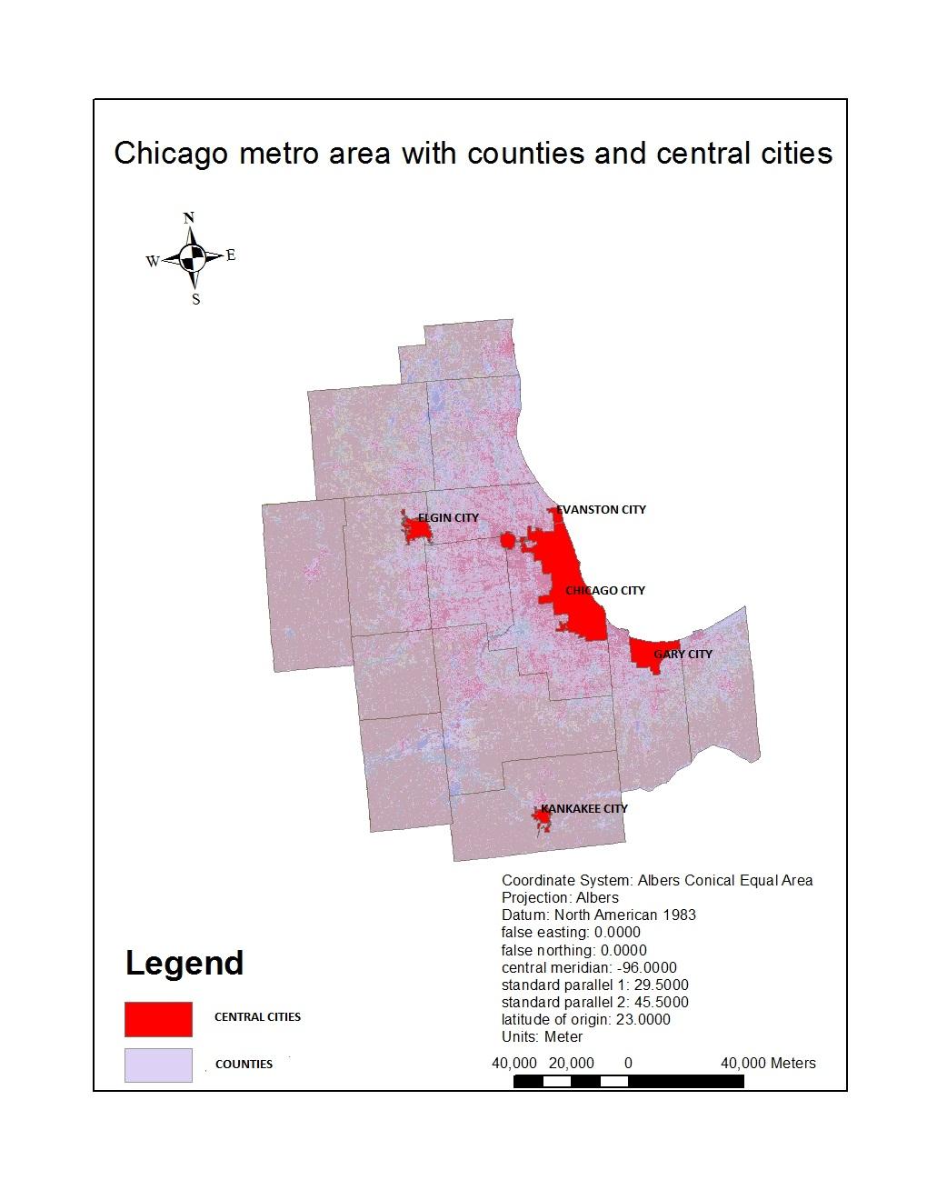
12 CCC Central Business District Rest of City of Chicago Lake Michigan Inner ring suburbs Outer ring suburbs Exurban areaxban area The Chicago MSA
13 Effect of Growth on Residence Location

14 Effect of Growth on Job Locations
15 Undeveloped land area (Urban sprawl)
16 Source: Joe the planner blog Commuting patterns United States Canada Residence Workplace 2000 Census (%) 2001 Census(%) Central city Central city Central city Suburb Suburb Central city Suburb Suburb Total Historical urban sprawl pattern in the Buffalo-Niagara Falls MSA

17 Source: Joe the planner blog,
18 Sprawl spreads development out over large amounts of land; puts long distances between homes, stores, and job centers; and makes people more and more dependent on driving in their daily lives.. Sprawl lengthens trips and forces us to drive everywhere. The average American driver currently spends the equivalent of 55 eight-hour workdays behind the wheel every year. (Sierra Club ).
19 VMT Traveled without Road Capacity Addition
20 VMT Traveled With Highway Capacity Additions
21 Stability of Commuting Time by Car
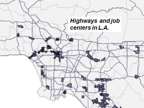
22 Other applications of the model Public transit share in commuting Employment dispersion Chicago, MSA 13% About 30% of jobs in the 4 largest job centers Ile-de-France (Greater Paris) 50% About 50% of jobs in the City of Paris and 10 surrounding centers Los Angeles, MSA 4.5% About 30% of jobs in the 30 largest job centers
 Chicago MSA 30% in 4 job centers Los")
23 How would new circumferential public transit links affect suburban job concentrations? Job Dispersal Greater Paris Region 50% in the core (city of Paris & CDTs) Chicago MSA 30% in 4 job centers Los Angeles MSA 30% in 30 job centers
24
25 0.35 Debarshi Indra, Choice of residence location and mode of commuting: a cross-sectional analysis of 275 US metropolitan areas (Working Paper) Housing cost elasticity Miami, 3.83% Houston, 3.24% LA, 4.67% Boston, 9.08% Washington, 8.45% Chicago, 11.41% New York, 24% Commuting time elasticity MSAs are shown with public transit shares
Can Public Transport Infrastructure Relieve Spatial Mismatch?
 Can Public Transport Infrastructure Relieve Spatial Mismatch? Evidence from Recent Light Rail Extensions Kilian Heilmann University of California San Diego April 20, 2015 Motivation Paradox: Even though
Lecture 19: Common property resources
 Lecture 19: Common property resources Economics 336 Economics 336 (Toronto) Lecture 19: Common property resources 1 / 19 Introduction Common property resource: A resource for which no agent has full property
Smart Growth: Threat to the Quality of Life. Experience
 Smart Growth: Threat to the Quality of Life Presentation by Wendell Cox Wendell Cox Consultancy Visiting Professor Conservatoire National des Arts et Metiers Paris Frontier Centre for Public Policy Winnipeg
Figure 8.2a Variation of suburban character, transit access and pedestrian accessibility by TAZ label in the study area
 Figure 8.2a Variation of suburban character, transit access and pedestrian accessibility by TAZ label in the study area Figure 8.2b Variation of suburban character, commercial residential balance and mix
THE MOST TRANSPARENT TREND in metropolitan areas is the decentralization of jobs and housing into
 AS JOBS SPRAWL, WHITHER THE COMMUTE? BY RANDALL CRANE AND DANIEL G. CHATMAN THE MOST TRANSPARENT TREND in metropolitan areas is the decentralization of jobs and housing into the suburbs and beyond. Scholars
Mapping Accessibility Over Time
 Journal of Maps, 2006, 76-87 Mapping Accessibility Over Time AHMED EL-GENEIDY and DAVID LEVINSON University of Minnesota, 500 Pillsbury Drive S.E., Minneapolis, MN 55455, USA; geneidy@umn.edu (Received
The effects of impact fees on urban form and congestion in Florida
 The effects of impact fees on urban form and congestion in Florida Principal Investigators: Andres G. Blanco Ruth Steiner Presenters: Hyungchul Chung Jeongseob Kim Urban and Regional Planning Contents
Contemporary Human Geography 3 rd Edition
 Chapter 13 Lecture Contemporary Human Geography 3 rd Edition Chapter 13: Urban Patterns Marc Healy Elgin Community College 13.1 The Central Business District The best-known and most visually distinctive
Urban Form and Travel Behavior:
 Urban Form and Travel Behavior: Experience from a Nordic Context! Presentation at the World Symposium on Transport and Land Use Research (WSTLUR), July 28, 2011 in Whistler, Canada! Petter Næss! Professor
Urban Revival in America
 Urban Revival in America Victor Couture 1 Jessie Handbury 2 1 University of California, Berkeley 2 University of Pennsylvania and NBER May 2016 1 / 23 Objectives 1. Document the recent revival of America
Key Issue 1: Why Do Services Cluster Downtown?
 Key Issue 1: Why Do Services Cluster Downtown? Pages 460-465 1. Define the term CBD in one word. 2. List four characteristics of a typical CBD. Using your knowledge of services from chapter 12, define
C) Discuss two factors that are contributing to the rapid geographical shifts in urbanization on a global scale.
 Discuss two factors that are contributing to the rapid geographical shifts in urbanization on a global scale.") AP Human Geography Unit VII. Cities and Urban Land Use Free Response Questions FRQ 1 Rapid urbanization in Least Developed Countries (LDCs) has many profound impacts for the world. Answer the following
AP Human Geography Unit VII. Cities and Urban Land Use Free Response Questions FRQ 1 Rapid urbanization in Least Developed Countries (LDCs) has many profound impacts for the world. Answer the following
Contemporary Human Geography 3 rd Edition
 Contemporary Human Geography 3 rd Edition Chapter 13: Urban Patterns Marc Healy Elgin Community College Services are attracted to the Central Business District (CBD) because of A. accessibility. B. rivers.
Travel behavior of low-income residents: Studying two contrasting locations in the city of Chennai, India
 Travel behavior of low-income residents: Studying two contrasting locations in the city of Chennai, India Sumeeta Srinivasan Peter Rogers TRB Annual Meet, Washington D.C. January 2003 Environmental Systems,
Changes in Transportation Infrastructure and Commuting Patterns in U.S. Metropolitan Areas,
 Changes in Transportation Infrastructure and Commuting Patterns in U.S. Metropolitan Areas, 1960-2000 Nathaniel Baum-Snow Department of Economics Box B Brown University Providence, RI 02912 Nathaniel_Baum-Snow@brown.edu
MULTIPLE CHOICE. Choose the one alternative that best completes the statement or answers the question.
 AP Test 13 Review Name MULTIPLE CHOICE. Choose the one alternative that best completes the statement or answers the question. 1) Compared to the United States, poor families in European cities are more
The Spatial Structure of Cities: International Examples of the Interaction of Government, Topography and Markets
 Module 2: Spatial Analysis and Urban Land Planning The Spatial Structure of Cities: International Examples of the Interaction of Government, Topography and Markets Alain Bertaud Urbanist Summary What are
FHWA Planning Data Resources: Census Data Planning Products (CTPP) HEPGIS Interactive Mapping Portal
 HEPGIS Interactive Mapping Portal") FHWA Planning Data Resources: Census Data Planning Products (CTPP) HEPGIS Interactive Mapping Portal Jeremy Raw, P.E. FHWA, Office of Planning, Systems Planning and Analysis August 2017 Outline Census
FHWA Planning Data Resources: Census Data Planning Products (CTPP) HEPGIS Interactive Mapping Portal Jeremy Raw, P.E. FHWA, Office of Planning, Systems Planning and Analysis August 2017 Outline Census
accessibility accessibility by-pass bid-rent curve bridging point administrative centre How easy or difficult a place is to reach.
 accessibility accessibility How easy or difficult a place is to reach. How easy or difficult it is to enter a building. administrative centre bid-rent curve The function of a town which is a centre for
The paper is based on commuting flows between rural and urban areas. Why is this of
 Commuting 1 The paper is based on commuting flows between rural and urban areas. Why is this of interest? Academically, extent of spread of urban agglomeration economies, also the nature of rural-urban
Online Robustness Appendix to Endogenous Gentrification and Housing Price Dynamics
 Online Robustness Appendix to Endogenous Gentrification and Housing Price Dynamics Robustness Appendix to Endogenous Gentrification and Housing Price Dynamics This robustness appendix provides a variety
Key Issue 1: Why Do Services Cluster Downtown?
 Key Issue 1: Why Do Services Cluster Downtown? Pages 460-465 ***Always keep your key term packet out whenever you take notes from Rubenstein. As the terms come up in the text, think through the significance
Your web browser (Safari 7) is out of date. For more security, comfort and the best experience on this site: Update your browser Ignore
 is out of date. For more security, comfort and the best experience on this site: Update your browser Ignore") Your web browser (Safari 7) is out of date. For more security, comfort and the best experience on this site: Update your browser Ignore urban area For the complete encyclopedic entry with media resources,
Your web browser (Safari 7) is out of date. For more security, comfort and the best experience on this site: Update your browser Ignore urban area For the complete encyclopedic entry with media resources,
Speakers: Jeff Price, Federal Transit Administration Linda Young, Center for Neighborhood Technology Sofia Becker, Center for Neighborhood Technology
 Speakers: Jeff Price, Federal Transit Administration Linda Young, Center for Neighborhood Technology Sofia Becker, Center for Neighborhood Technology Peter Haas, Center for Neighborhood Technology Craig
I-1. The slope of the bid-price function, P{u}, is - t / H. Use Equation (35) to derive general
 to derive general") ECN 741, Professor Yinger Exercises Part I. Bid Functions and Density Functions I-1. The slope of the bid-price function, P{u}, is - t / H. Use Equation (35) to derive general expression for the slope
ECN 741, Professor Yinger Exercises Part I. Bid Functions and Density Functions I-1. The slope of the bid-price function, P{u}, is - t / H. Use Equation (35) to derive general expression for the slope
The Elusive Connection between Density and Transit Use
 The Elusive Connection between Density and Transit Use Abstract: The connection between density and transportation is heralded by planners, yet results are often elusive. This paper analyzes two regions,
22 cities with at least 10 million people See map for cities with red dots
 22 cities with at least 10 million people See map for cities with red dots Seven of these are in LDC s, more in future Fastest growing, high natural increase rates, loss of farming jobs and resulting migration
A Note on Commutes and the Spatial Mismatch Hypothesis
 Upjohn Institute Working Papers Upjohn Research home page 2000 A Note on Commutes and the Spatial Mismatch Hypothesis Kelly DeRango W.E. Upjohn Institute Upjohn Institute Working Paper No. 00-59 Citation
GIS-Based Analysis of the Commuting Behavior and the Relationship between Commuting and Urban Form
 GIS-Based Analysis of the Commuting Behavior and the Relationship between Commuting and Urban Form 1. Abstract A prevailing view in the commuting is that commuting would reconstruct the urban form. By
THE LEGACY OF DUBLIN S HOUSING BOOM AND THE IMPACT ON COMMUTING
 Proceedings ITRN2014 4-5th September, Caulfield and Ahern: The Legacy of Dublin s housing boom and the impact on commuting THE LEGACY OF DUBLIN S HOUSING BOOM AND THE IMPACT ON COMMUTING Brian Caulfield
GIS Analysis of Crenshaw/LAX Line
 PDD 631 Geographic Information Systems for Public Policy, Planning & Development GIS Analysis of Crenshaw/LAX Line Biying Zhao 6679361256 Professor Barry Waite and Bonnie Shrewsbury May 12 th, 2015 Introduction
Chapter 12. Services
 Chapter 12 Services Where di services originate? Key Issue #1 Shoppers in Salzburg, Austria Origins & Types of Services Types of services Consumer services Business services Public services Changes in
Urban Growth and Transportation Development Patterns for China s Urban Transition
 Urban Growth and Transportation Development Patterns for China s Urban Transition Qisheng Pan Professor and Chair, Department of Urban Planning and Environmental Policy, Texas Southern University President,
Assessing spatial distribution and variability of destinations in inner-city Sydney from travel diary and smartphone location data
 Assessing spatial distribution and variability of destinations in inner-city Sydney from travel diary and smartphone location data Richard B. Ellison 1, Adrian B. Ellison 1 and Stephen P. Greaves 1 1 Institute
Regional Snapshot Series: Transportation and Transit. Commuting and Places of Work in the Fraser Valley Regional District
 Regional Snapshot Series: Transportation and Transit Commuting and Places of Work in the Fraser Valley Regional District TABLE OF CONTENTS Complete Communities Daily Trips Live/Work Ratio Commuting Local
Geospatial Analysis of Job-Housing Mismatch Using ArcGIS and Python
 Geospatial Analysis of Job-Housing Mismatch Using ArcGIS and Python 2016 ESRI User Conference June 29, 2016 San Diego, CA Jung Seo, Frank Wen, Simon Choi and Tom Vo, Research & Analysis Southern California
Urban Geography Unit Test (Version B)
") Urban Geography Unit Test (Version B) 1. What function do the majority of the world s ten most populated cities serve? a. a fortress city to resist foreign invasion b. a port city for transporting people
Urban Geography Unit Test (Version B) 1. What function do the majority of the world s ten most populated cities serve? a. a fortress city to resist foreign invasion b. a port city for transporting people
Spatial profile of three South African cities
 Spatial Outcomes Workshop South African Reserve Bank Conference Centre Pretoria September 29-30, 2009 Spatial profile of three South African cities by Alain Bertaud September 29 Email: duatreb@msn.com
Changes in Land Use, Transportation System and the Mobility in Gifu by using Historical Map, Statistics and Personal Trip Survey Data
 Changes in Land Use, Transportation System and the Mobility in Gifu by using Historical Map, Statistics and Personal Trip Survey Data Min GUO 1, Fumitaka KURAUCHI 2 1 DC, Graduate School of Eng., Gifu
Spatiotemporal Analysis of Commuting Patterns: Using ArcGIS and Big Data
 Spatiotemporal Analysis of Commuting Patterns: Using ArcGIS and Big Data 2017 ESRI User Conference July 13, 2017 San Diego, VA Jung Seo, Tom Vo, Frank Wen and Simon Choi Research & Analysis Southern California
Too Close for Comfort
 Too Close for Comfort Overview South Carolina consists of urban, suburban, and rural communities. Students will utilize maps to label and describe the different land use classifications. Connection to
Economic and Social Urban Indicators: A Spatial Decision Support System for Chicago Area Transportation Planning
 Economic and Social Urban Indicators: A Spatial Decision Support System for Chicago Area Transportation Planning Piyushimita Thakuriah (Vonu), P.S. Sriraj, Paul Metaxatos, Inshu Minocha & Tanushri Swarup
Forecasts for the Reston/Dulles Rail Corridor and Route 28 Corridor 2010 to 2050
 George Mason University Center for Regional Analysis Forecasts for the Reston/Dulles Rail Corridor and Route 28 Corridor 21 to 25 Prepared for the Fairfax County Department of Planning and Zoning Lisa
Research Update: Race and Male Joblessness in Milwaukee: 2008
 Research Update: Race and Male Joblessness in Milwaukee: 2008 by: Marc V. Levine University of Wisconsin Milwaukee Center for Economic Development Briefing Paper September 2009 Overview Over the past decade,
The Role of Transitways in Our Region s Economic Competitiveness. The 23rd CTS Annual Research Conference St. Paul, MN May 23, 2012
 The Role of Transitways in Our Region s Economic Competitiveness The 23rd CTS Annual Research Conference St. Paul, MN May 23, 2012 1 2 Twin Cities Competitive Clusters 3 Competitive Clusters interconnected
How Geography Affects Consumer Behaviour The automobile example
 How Geography Affects Consumer Behaviour The automobile example Murtaza Haider, PhD Chuck Chakrapani, Ph.D. We all know that where a consumer lives influences his or her consumption patterns and behaviours.
Labor Market Polarization and a Changing Recovery in the Chicago Metropolitan Area
 Labor Market Polarization and a Changing Recovery in the Chicago Metropolitan Area Executive Summary High-Wage Middle-Wage Low-Wage Exhibit 1: Change in Total Jobs by Wage Tier (2006-2015) -3.0% 0.0% 2.5%
Social Studies Grade 2 - Building a Society
 Social Studies Grade 2 - Building a Society Description The second grade curriculum provides students with a broad view of the political units around them, specifically their town, state, and country.
Spatial and Socioeconomic Analysis of Commuting Patterns in Southern California Using LODES, CTPP, and ACS PUMS
 Spatial and Socioeconomic Analysis of Commuting Patterns in Southern California Using LODES, CTPP, and ACS PUMS Census for Transportation Planning Subcommittee meeting TRB 95th Annual Meeting January 11,
Location theory and clusters. Dr. Hans Koster Assistant professor
 Dr. Hans Koster Assistant professor 1 Internal economies of scale (EofS) can lead to Trading cities (EofS in transport) Factory cities (EofS in production) But where do cities emerge? Why is Colombo located
Using the ACS to track the economic performance of U.S. inner cities
 Using the ACS to track the economic performance of U.S. inner cities 2017 ACS Data Users Conference May 11, 2017 Austin Nijhuis, Senior Research Analyst Initiative for a Competitive Inner (ICIC) ICIC ICIC
The Economics of Density: Evidence from the Berlin Wall
 The Economics of Density: Evidence from the Berlin Wall Ahlfeldt, Redding, Sturm and Wolf, Econometrica 2015 Florian Oswald Graduate Labor, Sciences Po 2017 April 13, 2017 Florian Oswald (Graduate Labor,
Land Use Modeling at ABAG. Mike Reilly October 3, 2011
 Land Use Modeling at ABAG Mike Reilly michaelr@abag.ca.gov October 3, 2011 Overview What and Why Details Integration Use Visualization Questions What is a Land Use Model? Statistical relationships between
COMMUTING ANALYSIS IN A SMALL METROPOLITAN AREA: BOWLING GREEN KENTUCKY
 Papers of the Applied Geography Conferences (2007) 30: 86-95 COMMUTING ANALYSIS IN A SMALL METROPOLITAN AREA: BOWLING GREEN KENTUCKY Caitlin Hager Jun Yan Department of Geography and Geology Western Kentucky
Towards a Co-ordinated Planning of Infrastructure and Urbanization
 Towards a Co-ordinated Planning of Infrastructure and Urbanization Problems, Solutions and Conditions for Success in the current Dutch Policy and Planning Practice Content of presentation Content of presentation
URBAN SPRAWL, JOB DECENTRALIZATION, AND CONGESTION: THE WELFARE EFFECTS OF CONGESTION TOLLS AND URBAN GROWTH BOUNDARIES
 URBAN SPRAWL, JOB DECENTRALIZATION, AND CONGESTION: THE WELFARE EFFECTS OF CONGESTION TOLLS AND URBAN GROWTH BOUNDARIES Wenjia Zhang City and Regional Planning Program School of Architecture The University
Economics 312: Urban Land Economics University of Victoria Midterm Examination #1 VERSION 1 SOLUTIONS Spring 2018 Instructor: Martin Farnham
 Economics 312: Urban Land Economics University of Victoria Midterm Examination #1 VERSION 1 SOLUTIONS Spring 2018 Instructor: Martin Farnham Midterm Exam #1 Section 1: Multiple Choice (2 points each) Unless
Discerning sprawl factors of Shiraz city and how to make it livable
 Discerning sprawl factors of Shiraz city and how to make it livable 1. Introduction: Iran territory has now been directly affected by urban land-uses which are shaping landscapes in cities and around them.
Lecture 6: Transport Costs and Congestion Forces
 Lecture 6: Transport Costs and Congestion Forces WWS 538 Esteban Rossi-Hansberg Princeton University ERH (Princeton University ) Lecture 6: Transport Costs and Congestion Forces 1 / 43 Baum-Snow (2007)
Public Transport Versus Private Car: GIS-Based Estimation of Accessibility Applied to the Tel Aviv Metropolitan Area
 Public Transport Versus Private Car: GIS-Based Estimation of Accessibility Applied to the Tel Aviv Metropolitan Area Itzhak Benenson 1, Karel Martens 3, Yodan Rofe 2, Ariela Kwartler 1 1 Dept of Geography
THE FUTURE OF FORECASTING AT METROPOLITAN COUNCIL. CTS Research Conference May 23, 2012
 THE FUTURE OF FORECASTING AT METROPOLITAN COUNCIL CTS Research Conference May 23, 2012 Metropolitan Council forecasts Regional planning agency and MPO for Twin Cities metropolitan area Operates regional
The Impact of Residential Density on Vehicle Usage and Fuel Consumption: Evidence from National Samples
 The Impact of Residential Density on Vehicle Usage and Fuel Consumption: Evidence from National Samples Jinwon Kim Department of Transport, Technical University of Denmark and David Brownstone 1 Department
Decentralisation and its efficiency implications in suburban public transport
 Decentralisation and its efficiency implications in suburban public transport Daniel Hörcher 1, Woubit Seifu 2, Bruno De Borger 2, and Daniel J. Graham 1 1 Imperial College London. South Kensington Campus,
Impact of Metropolitan-level Built Environment on Travel Behavior
 Impact of Metropolitan-level Built Environment on Travel Behavior Arefeh Nasri 1 and Lei Zhang 2,* 1. Graduate Research Assistant; 2. Assistant Professor (*Corresponding Author) Department of Civil and
Sustainable Suburbs: Restructuring Suburban Development
 Sustainable Suburbs: Restructuring Suburban Development Stephen B. Friedman, AICP, CRE ULI Forum, October 8, 2009 The Vocabulary of Growth CAVE NIMBY BANANA NOTE NOPE NIMEY Triple Bottom Line Profitability
c. What is the most distinctive above ground result of high land costs and intensive land use? i. Describe the vertical geography of a skyscraper?
 AP Human Geography Unit 7b Guided Reading: Urban Patterns and Social Issues Mr. Stepek Key Issue #1: Why Do Services Cluster Downtown? (Rubenstein p 404 410) 1. What is the CBD? What does it contain and
Do the Causes of Poverty Vary by Neighborhood Type?
 Do the Causes of Poverty Vary by Neighborhood Type? Suburbs and the 2010 Census Conference Uday Kandula 1 and Brian Mikelbank 2 1 Ph.D. Candidate, Maxine Levin College of Urban Affairs Cleveland State
Factors Affecting Human Settlement
 Factors Affecting Human Settlement Physical Factors One of the most basic factors affecting settlement patterns is the physical geography of the land. Climate is key, because if a place is too dry, too
The impact of residential density on vehicle usage and fuel consumption*
 The impact of residential density on vehicle usage and fuel consumption* Jinwon Kim and David Brownstone Dept. of Economics 3151 SSPA University of California Irvine, CA 92697-5100 Email: dbrownst@uci.edu
Encapsulating Urban Traffic Rhythms into Road Networks
 Encapsulating Urban Traffic Rhythms into Road Networks Junjie Wang +, Dong Wei +, Kun He, Hang Gong, Pu Wang * School of Traffic and Transportation Engineering, Central South University, Changsha, Hunan,
Difference in regional productivity and unbalance in regional growth
 Difference in regional productivity and unbalance in regional growth Nino Javakhishvili-Larsen and Jie Zhang - CRT, Denmark, Presentation at 26 th International input-output conference in Brazil Aim of
TRAFFIC AND SPRAWL: EVIDENCE FROM U.S. COMMUTING, 1985 TO 1997*
 TRAFFIC AND SPRAWL: EVIDENCE FROM U.S. COMMUTING, 1985 TO 1997* by Randall Crane Daniel Chatman Department of Urban Planning Department of Urban Planning University of California University of California
Changes in the Spatial Distribution of Mobile Source Emissions due to the Interactions between Land-use and Regional Transportation Systems
 Changes in the Spatial Distribution of Mobile Source Emissions due to the Interactions between Land-use and Regional Transportation Systems A Framework for Analysis Urban Transportation Center University
Spatiotemporal Analysis of Commuting Patterns in Southern California Using ACS PUMS, CTPP and LODES
 Spatiotemporal Analysis of Commuting Patterns in Southern California Using ACS PUMS, CTPP and LODES 2017 ACS Data Users Conference May 11-12, 2017 Alexandria, VA Jung Seo, Tom Vo, Frank Wen and Simon Choi
Problems In Large Cities
 Chapter 11 Problems In Large Cities Create a list of at least 10 problems that exist in large cities. Consider problems that you have read about in this and other chapters and/or experienced yourself.
Presentation of Travel Demand. And. Relationships to Land Use. Prepared for The Delaware Transportation Institute. David P. Racca
 Presentation of Travel Demand And Relationships to Land Use Prepared for The Delaware Transportation Institute By David P. Racca Center for Applied Demography and Survey Research College of Human Services,
EVALUATION OF COMMUTE EFFICIENCY: DESIGN AND SIMULATION OF FUTURE URBAN FORM SCENARIOS IN WINDSOR, ONTARIO ( )
") EVALUATION OF COMMUTE EFFICIENCY: DESIGN AND SIMULATION OF FUTURE URBAN FORM SCENARIOS IN WINDSOR, ONTARIO (2011 2031) Serena (Zhongyuan) Tang, MASc Student (tang1q@uwindsor.ca) Hanna Maoh, Assistant Professor
EVALUATION OF COMMUTE EFFICIENCY: DESIGN AND SIMULATION OF FUTURE URBAN FORM SCENARIOS IN WINDSOR, ONTARIO (2011 2031) Serena (Zhongyuan) Tang, MASc Student (tang1q@uwindsor.ca) Hanna Maoh, Assistant Professor
Transit Modeling Update. Trip Distribution Review and Recommended Model Development Guidance
 Transit Modeling Update Trip Distribution Review and Recommended Model Development Guidance Contents 1 Introduction... 2 2 FSUTMS Trip Distribution Review... 2 3 Proposed Trip Distribution Approach...
Community Development, Economic Development, or Community Economic Development? Concepts, Tools and Practices
 Community Development, Economic Development, or Community Economic Development? Concepts, Tools and Practices Location Theory: Part I Location theory helps us one basic question: why does economic activity
APPENDIX I: Traffic Forecasting Model and Assumptions
 APPENDIX I: Traffic Forecasting Model and Assumptions Appendix I reports on the assumptions and traffic model specifications that were developed to support the Reaffirmation of the 2040 Long Range Plan.
StanCOG Transportation Model Program. General Summary
 StanCOG Transportation Model Program Adopted By the StanCOG Policy Board March 17, 2010 What are Transportation Models? General Summary Transportation Models are technical planning and decision support
Urban Economics City Size
 Urban Economics City Size Utility and City Size Question: Why do cities differ in size and scope? While NYC has a population of more 18 million, the smallest urban area in the U.S. has only 13,000. A well
Advancing Urban Models in the 21 st Century. Jeff Tayman Lecturer, Dept. of Economics University of California, San Diego
 Advancing Urban Models in the 21 st Century Jeff Tayman Lecturer, Dept. of Economics University of California, San Diego 1 Regional Decision System Better tools Better data Better access Better Decisions
Human Geography. Urban Development. Urban Development. Urban Development. Unit 8: Urban Development. I. Why are Settlements Established?
 I. Why are Settlements Established? A. Rural Settlements B. Urban Settlements Human Geography Unit 8: I. Why are Settlements Established? C. REASONS FOR ESTABLLISHING SETTLEMENTS 1. Cultural Religious
Density and Walkable Communities
 Density and Walkable Communities Reid Ewing Professor & Chair City and Metropolitan Planning University of Utah ewing@arch.utah.edu Department of City & Metropolitan Planning, University of Utah MRC Research
Effects of Urban Rail Transit Expansions: Evidence from Sixteen Cities,
 NATHANIEL BAUM-SNOW Brown University MATTHEW E. KAHN Tufts University Effects of Urban Rail Transit Expansions: Evidence from Sixteen Cities, 1970 2000 FEDERAL, STATE, AND LOCAL governments have spent
Aula 27: From Rivers to Roads Spatial Mismatch and Inequality of Opportunity in Urban Labor Markets of a Megacity
 Aula 27: From Rivers to Roads Spatial Mismatch and Inequality of Opportunity in Urban Labor Markets of a Megacity Eduardo A. Haddad Ana Maria B. Barufi Special issue: Smart Development, Spatial Sustainability
Subject: Note on spatial issues in Urban South Africa From: Alain Bertaud Date: Oct 7, A. Spatial issues
 Page 1 of 6 Subject: Note on spatial issues in Urban South Africa From: Alain Bertaud Date: Oct 7, 2009 A. Spatial issues 1. Spatial issues and the South African economy Spatial concentration of economic
New Frameworks for Urban Sustainability Assessments: Linking Complexity, Information and Policy
 New Frameworks for Urban Sustainability Assessments: Linking Complexity, Information and Policy Moira L. Zellner 1, Thomas L. Theis 2 1 University of Illinois at Chicago, Urban Planning and Policy Program
Access Across America: Transit 2017
 Access Across America: Transit 2017 Final Report Prepared by: Andrew Owen Brendan Murphy Accessibility Observatory Center for Transportation Studies University of Minnesota CTS 18-12 1. Report No. CTS
Dimantha I De Silva (corresponding), HBA Specto Incorporated
, HBA Specto Incorporated") Paper Author (s) Dimantha I De Silva (corresponding), HBA Specto Incorporated (dds@hbaspecto.com) Daniel Flyte, San Diego Association of Governments (SANDAG) (Daniel.Flyte@sandag.org) Matthew Keating,
Paper Author (s) Dimantha I De Silva (corresponding), HBA Specto Incorporated (dds@hbaspecto.com) Daniel Flyte, San Diego Association of Governments (SANDAG) (Daniel.Flyte@sandag.org) Matthew Keating,
SPATIAL ANALYSIS OF URBAN BUILT ENVIRONMENTS AND VEHICLE TRANSIT BEHAVIOR. Daniel Currie Eisman
 SPATIAL ANALYSIS OF URBAN BUILT ENVIRONMENTS AND VEHICLE TRANSIT BEHAVIOR by Daniel Currie Eisman A Thesis Presented to the FACULTY OF THE USC GRADUATE SCHOOL UNIVERSITY OF SOUTHERN CALIFORNIA In Partial
Trip Generation Model Development for Albany
 Trip Generation Model Development for Albany Hui (Clare) Yu Department for Planning and Infrastructure Email: hui.yu@dpi.wa.gov.au and Peter Lawrence Department for Planning and Infrastructure Email: lawrence.peter@dpi.wa.gov.au
Measuring connectivity in London
 Measuring connectivity in London OECD, Paris 30 th October 2017 Simon Cooper TfL City Planning 1 Overview TfL Connectivity measures in TfL PTALs Travel time mapping Catchment analysis WebCAT Current and
Economic consequences of floods: impacts in urban areas
 Economic consequences of floods: impacts in urban areas SWITCH Paris Conference Paris, 24 th 26 th January 2011 Economic consequences of floods: impacts in urban areas Institutions: Authors Vanessa Cançado
Influencing factors behind urban sprawl in the United States
 University of Northern Iowa UNI ScholarWorks Honors Program Theses University Honors Program 2011 Influencing factors behind urban sprawl in the United States Charles N. Cowell University of Northern Iowa
Developing the Transit Demand Index (TDI) Gregory Newmark, Regional Transportation Authority Transport Chicago Presentation July 25, 2012
 Gregory Newmark, Regional Transportation Authority Transport Chicago Presentation July 25, 2012") Developing the Transit Demand Index (TDI) Gregory Newmark, Regional Transportation Authority Transport Chicago Presentation July 25, 2012 Outline Present RTA methodology Transit Demand Index (TDI) Demonstrate
Developing the Transit Demand Index (TDI) Gregory Newmark, Regional Transportation Authority Transport Chicago Presentation July 25, 2012 Outline Present RTA methodology Transit Demand Index (TDI) Demonstrate
Leveraging Urban Mobility Strategies to Improve Accessibility and Productivity of Cities
 Leveraging Urban Mobility Strategies to Improve Accessibility and Productivity of Cities Aiga Stokenberga World Bank GPSC African Regional Workshop May 15, 2018 Roadmap 1. Africa s urbanization and its
CIV3703 Transport Engineering. Module 2 Transport Modelling
 CIV3703 Transport Engineering Module Transport Modelling Objectives Upon successful completion of this module you should be able to: carry out trip generation calculations using linear regression and category
Changes in Land Use, Socioeconomic Indices, and the Transportation System in Gifu City and their Relevance during the Late 20th Century
 Open Journal of Civil Engineering, 2012, 2, 183-192 http://dx.doi.org/10.4236/ojce.2012.23024 Published Online September 2012 (http://www.scirp.org/journal/ojce) Changes in Land Use, Socioeconomic Indices,