What are the main characteristics of a CBD? next four slides?
|
|
|
- Hubert Elliott
- 6 years ago
- Views:
Transcription
1
2 What are the main characteristics of a CBD? How many characteristics of a CBD can you spot in the How many characteristics of a CBD can you spot in the next four slides?


3 The Tallest Buildings Why? What typical characteristics of a CBD are shown here? Public Buildings eg. Corn Exchange / Town Hall Busy lots of pedestrians Markets

4 Purpose built shopping centres providing undercover shopping experience What typical characteristics of a CBD are shown here? Big Department Stores and National Chain Stores why?


5 What typical characteristics of a CBD are shown here? Some of the oldest buildings Public Buildings eg. Corn Exchange / Town Hall Historic/ old street pattern often some narrow streets Very accessible public transport & traffic management required due to congestion.


6 Entertainment e.g. restaurants Entertainment e.g. pubs What typical characteristics of a CBD are shown here? Entertainment e.g. cinemas Entertainment e.g. cinemas (although increasingly these are moving further out of town)


7 A CASE STUDY OF URBAN TRAFFIC MANAGEMENT CAMBRIDGE - UK
8 CAUSES OF TRAFFIC PROBLEMS IN CAMBRIDGE CBD oldest part of city road network originally built for horse- drawn traffic not able to cope with high h traffic flows (many narrow roads) Increased card ownership over the last 50 years with increasing i wealth Last 40 years decrease in rail services & more people on the road Commuter traffic increasingly i a problem (people travelling into the city to work) More people travelling in for shopping / entertainment
9 What are the Traffic Problems in Cambridge? Heavy Traffic Congestion particularly in rush hours make deliveries / people late Movement of traffic slow in narrow streets High volume of through traffic High pollution levels from exhaust (particularly in hot summer conditions) Lost work hours (workers increasingly late due to congestion) costs employers Shortage of Parking Problems for emergency services trying to get through congested streets


10 What are the solutions to traffic problems in Cambridge? MULTI-STOREY CAR PARKS e.g. Lion Yard (Cambridge) Grafton Centre Parking etc. Gonville Place etc. Why needed?
11 CYCLE LANES And BUS LANES Why?
12 ONE WAY STREETS e.g. Downing Street Why?


13 RISING BOLLARDS Why? e.g. outside Kings College Chapel
14 TRAFFIC CALMING IN RESIDENTIAL AREAS e.g. forced Give Way Speed reducing bollards etc. Why needed?


15 PARK AND RIDE e.g. Trumpington Cowley Road Madingley Road Why?


16 PEDESTRIANISED AREAS e.g. Sidney Streett Trinity Street etc. Why needed?
17 Other Traffic Management Measures: M11 / A14 forming N-S and E-W City Bypasses taking through traffic around the town (allows more continuous / faster flowing traffic in town) Increase Car Parking Fees (discourage traffic in centre encourage use of public transport) Possible solutions in the future: Road Pricing e.g. like the congestion charge in London Encouraging g car-sharing etc. Photograph Source: from Google Image searches purely used for educational use no commercial gain.
18 THE INNER CITY (ZONE 2) Also known as the Twilight or Transition Zone


19 Zone 2 of the Urban Land-use Model THE INNER CITY Typical aerial view of an Inner City Area Typical style of housing in the Inner City
20


21 When and Why did Inner City Areas Grow up? Developed during the 19 th century due to rapid expansion of industry (led to the demand for workers) As more moved to the cities there was a demand for low cost houses for the workers This resulted in high-density cheap housing (fitting as many houses as possible in a small area People had to live close to work due to lack of transport


")

22 What types of land-use are found in Inner City areas? 19 th Century Terraced Housing Industry large factories built during the industrial revolution (now some knocked down / converted) Canals and Railways Main Roads (often now ring roads taking traffic out of CBDs)


")
23 Typical Characteristics of Inner City Areas High Density Housing Mainly terraced (some back to back) Built in Long Straight Rows Front doors opening onto the street Few Amenities (little or no sanitation (often built with toilet in Back Yard Mainly Ethnic Minorities, students, older people and unemployed (lower income groups) Mainly private / rented
 1.")


24 Problems in Inner City Areas (since 1950s / 1950s) 1. Industrial Decline (see other notes) 6. Overcrowding 2. High unemployment 3. Abandoned Warehouses eyesore and led to vandalism 4. High Crime Rates 5. Poor Quality Housing 7. Lack of Open Space 8. Lack of Parking Spaces 9. Atmospheric Pollution (factories / traffic) 10. Lots of heavy traffic (for industry)
25 LOCATION: East End of London 12 mile stretch downstream, includes Tower Hamlets, Greenwich, Newham and Southwark A Case Study of Urban Redevelopment / Renewal THE LONDON DOCKLANDS


26 THE LONDON DOCKLANDS Pre 1950s During the 19 th Century and up to the 1950s, London s port was the busiest in the world, however even before the 1950s, the area was starting to lose trade.


27 CAUSES OF DECLINE IN THE LONDON DOCKLANDS 1. The increasing size of ships meant they found it difficult to come as far down the River Thames as the Isle of Dogs (The position of the docks moved further downstream e.g. Tilbury) 2. Manufacturing declined and many portside industries closed. 3. Tower blocks / low quality housing built in the 1950s and 1960s to replace the housing damaged during the Second World War. 4. Containerization meant fewer dockers were needed as cranes were used to lift containers from the ships
28 PROBLEMS IN THE LONDON DOCKLANDS IN THE 1980s Shopping many small stores / corner shops no modern shopping centres Industry over half of Docklands was derelict many empty factories / warehouses the docks themselves were unused Transport narrow congested roads many heavy lorries parking a problem Employment decline of industries resulting in loss of jobs & high unemployment Open Space virtually none almost all land developed few leisure amenities Industry mainly high density terraced houses up to 100 yrs old Houses were small lacked modern amenities. But there was a strong East Enders community spirit
29 THE DOCKS BEFORE REDEVELOPMENT Source: hi t


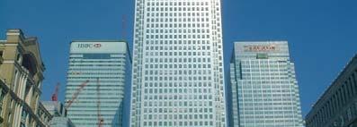


30 AFTER Mudchute City Farm Canary Wharf Docklands Light Railway The Dome Canary Wharf CANARY WHARF Construction and final! HSBC Building


31 WHO HAS BEEN INVOLVED IN HELPING WITH THE REGENERATION PROCESS? Local Housing Association obtained home improvement grants LDDC (London Docklands Development Corporation) responsible for planning and redevelopment of the Docklands area. National Government created Isle of Dogs enterprise zone offering financial help and reduced rates Property Developers built large office blocks e.g. Canary Whart Conservation Groups created schemes to improve the environment Newham Council built low-cost housing / upgraded properties.
32 LONDON DOCKLANDS REDEVELOPMENT Solving the Problems Have a go at sorting these into Social, Economic and Environmental Solutions Improved transport links e.g. new roads (including link to M1 and the building of the Docklands Light Railway Financial and High tech industries were attracted to the area as the LDDC promised low rates e.g. Stock Exchange & newspapers and TV studios. The National government created enterprise zones promising i low rates to businesses Huge new office blocks like canary wharf were built City airport was built in the Royal Docks 100 million was spent on education, health and training Conservation areas were created and waterside walks and cycle paths were built. Mudchute city farm was opened. Derelict land was reclaimed, trees were planted and parkland was created Over 20,000 new houses & flats were built (including luxury flats) and many old terraces have been cleared / renovated New shopping centres were developed, a national indoor sports arena and a marina for watersports as well as a hotel / conference centre (EXCEL) Employment doubled (unemployment fell) by 1999, 16,000 new jobs had been created.
33 HOW SUCCESSFUL WAS THE LONDON DOCKLAND REDEVELOPMENT? Read through the following and try and identify the winners and losers Diagram Source: Westoby, G New Wider World Foundation Edition Teacher Resources
34
35 INNER AND OUTER SUBURBS Reasons for Growth of the Suburbs 1. Better public transport and increased car ownership meant people could separate work from where they live. 2. Building societies provided mortgages making it easier to buy homes 3. People were better off and looking for a better living environment.
36 RURAL-URBAN FRINGE This has lead to conflict due to different land-uses wanting This has lead to conflict due to different land uses wanting to locate here (see diagram for examples)


37 APPLYING THE LAND-USE MODEL TO ST IVES
38 THE CBD
39 THE CBD
40 THE CBD
41 THE INNER CITY
42 THE INNER CITY
43 THE INNER CITY
44 THE INNER SUBURBS
45 THE INNER SUBURBS
46 THE INNER SUBURBS
47 THE OUTER SUBURBS
48 THE OUTER SUBURBS
49 RETAIL ON RURAL-URBAN FRINGE
50 INDUSTRY ON RURAL-URBAN FRINGE


51 URBAN LAND-USE TRANSECT IN ST IVES CBD Inner City Inner Suburbs Outer Suburbs Industry Tallest Buildings Shops Entertainment High Land Values High Density Terraced Housing Some old factories Semi- detached housing Some greenery Gardens Low density housing Large detached houses Garages Gardens Rural-urban fringe Industry Retail Units Car parking space Examples: Market Hill East Street Green Leys Burleigh Hill Rainbow
52
53
54
55
56
57
58
59
60
61
62
63
64
65
accessibility accessibility by-pass bid-rent curve bridging point administrative centre How easy or difficult a place is to reach.
 accessibility accessibility How easy or difficult a place is to reach. How easy or difficult it is to enter a building. administrative centre bid-rent curve The function of a town which is a centre for
IFHP Congress. Track 2 : Regenerating the East. Eric Sorensen, 11 June 2013
 IFHP Congress Track 2 : Regenerating the East Eric Sorensen, 11 June 2013 London Geography Port of London Docklands Abandoned Canary Wharf Abandoned Canary Wharf: 1982 THE 1970s - A LOST DECADE Everyone
Exemplar for Internal Achievement Standard. Geography Level 2
 Exemplar for Internal Achievement Standard Geography Level 2 This exemplar supports assessment against: Achievement Standard 91241 Demonstrate geographic understanding of an urban pattern An annotated
It is clearly necessary to introduce some of the difficulties of defining rural and
 UNIT 2 CHANGING HUMAN ENVIRONMENTS G2 Theme 2 Investigating Settlement Change in MEDCs 2.1 What are the distinctive features of settlements? It is clearly necessary to introduce some of the difficulties
Urban White Paper on Tokyo Metropolis 2002
 Urban White Paper on Tokyo Metropolis 2002 By Bureau of City Planning Tokyo Metropolitan Government Part I. "Progress in IT and City Building" Effects of computer networks on cities and cities' response
The Changing Fortunes of London's Docklands
 The Changing Fortunes of London's Docklands - presentation by Stuart Innes Regeneration and Renewal Conference - Birmingham Wednesday 1 st April 2009 About Stuart Innes. 1961-1980: civil servant in the
A new type of RICEPOTS
 A new type of RICEPOTS Alan Parkinson Geography teaching resource College Crown Copyright and Database Right 2014. Ordnance Survey (Digimap Licence) This is one of a series of teaching resources for use
MULTIPLE CHOICE. Choose the one alternative that best completes the statement or answers the question.
 AP Test 13 Review Name MULTIPLE CHOICE. Choose the one alternative that best completes the statement or answers the question. 1) Compared to the United States, poor families in European cities are more
Edexcel Geography Advanced Paper 2
 Edexcel Geography Advanced Paper 2 SECTION B: SHAPING PLACES Assessment objectives AO1 Demonstrate knowledge and understanding of places, environments, concepts, processes, interactions and change, at
Urban Planning Word Search Level 1
 Urban Planning Word Search Level 1 B C P U E C O S Y S T E M P A R E U O E U R B A N P L A N N E R T N S T D H E C O U N T Y G E R E R D W R E N I C I T Y C O U N C I L A A A S U G G C I L A G P R I R
Key Issue 1: Why Do Services Cluster Downtown?
 Key Issue 1: Why Do Services Cluster Downtown? Pages 460-465 1. Define the term CBD in one word. 2. List four characteristics of a typical CBD. Using your knowledge of services from chapter 12, define
APPLIED FIELDWORK ENQUIRY SAMPLE ASSESSMENT MATERIALS
 GCSE GEOGRAPHY B Sample Assessment Materials 85 GCSE GEOGRAPHY B COMPONENT 3 APPLIED FIELDWORK ENQUIRY SAMPLE ASSESSMENT MATERIALS 1 hour 30 minutes For examiner s use only SPaG Part A 18 0 Part B 18 0
Response to the Local Government Boundary Commission for England proposals for new electoral arrangements for Leeds City Council
 Response to the Local Government Boundary Commission for England proposals for new electoral arrangements for Leeds City Council This is the Leeds Liberal Democrat response to the Draft Recommendations
Foreword. Vision and Strategy
 GREATER MANCHESTER SPATIAL FRAMEWORK Friends of Walkden Station Consultation Response January 2017 Foreword Friends of Walkden Station are a group of dedicated volunteers seeking to raise the status and
CHAPTER 2. Strategic Context
 CHAPTER 2 Strategic Aim: To facilitate the future development of Cork as a national gateway city within the integrated land use and transportation framework set out in the Cork Area Strategic Plan 2001
Too Close for Comfort
 Too Close for Comfort Overview South Carolina consists of urban, suburban, and rural communities. Students will utilize maps to label and describe the different land use classifications. Connection to
Key Issue 1: Why Do Services Cluster Downtown?
 Key Issue 1: Why Do Services Cluster Downtown? Pages 460-465 ***Always keep your key term packet out whenever you take notes from Rubenstein. As the terms come up in the text, think through the significance
c. What is the most distinctive above ground result of high land costs and intensive land use? i. Describe the vertical geography of a skyscraper?
 AP Human Geography Unit 7b Guided Reading: Urban Patterns and Social Issues Mr. Stepek Key Issue #1: Why Do Services Cluster Downtown? (Rubenstein p 404 410) 1. What is the CBD? What does it contain and
GCSE Geography A. Mark Scheme for June Unit A7321/02: Geographical skills (Higher Tier) General Certificate of Secondary Education
 General Certificate of Secondary Education") GCSE Geography A Unit A7321/02: Geographical skills (Higher Tier) General Certificate of Secondary Education Mark Scheme for June 2014 Oxford Cambridge and RSA Examinations OCR (Oxford Cambridge and RSA)
GCSE Geography A Unit A7321/02: Geographical skills (Higher Tier) General Certificate of Secondary Education Mark Scheme for June 2014 Oxford Cambridge and RSA Examinations OCR (Oxford Cambridge and RSA)
What lessons for future urban regeneration in East London can be learnt from projects in the past?
 What lessons for future urban regeneration in East London can be learnt from projects in the past? Year 11 Geography fieldtrip January 2008 1 Aim of the day The aim of today s fieldwork is to study four
Data driven approaches to Urban Planning Experience from Derry/Londonderry
 Data driven approaches to Urban Planning Experience from Derry/Londonderry Anna Rose RTPI Belfast 11 th of September 1 June 26 07:47AM 2 The value of the City The space of the city is a theatre: playing
Economic Geography of the Long Island Region
 Geography of Data Economic Geography of the Long Island Region Copyright 2011 AFG 1 The geography of economic activity requires: - the gathering of spatial data - the location of data geographically -
You need Geography Alive Textbook Calculator Warm Up Do you like crowded places or do you prefer places where there are fewer people? (ex.
 You need Geography Alive Textbook Calculator Warm Up Do you like crowded places or do you prefer places where there are fewer people? (ex. parties, shopping, etc.) Why? Turn to Page 445 and define Arable
Urban Geography Unit Test (Version B)
") Urban Geography Unit Test (Version B) 1. What function do the majority of the world s ten most populated cities serve? a. a fortress city to resist foreign invasion b. a port city for transporting people
Urban Geography Unit Test (Version B) 1. What function do the majority of the world s ten most populated cities serve? a. a fortress city to resist foreign invasion b. a port city for transporting people
Shrinking Cities. Economic Geography Dr. Gordon Winder Summer Term 2008 Georgina Gilchrist
 Shrinking Cities Economic Geography Dr. Gordon Winder Summer Term 2008 Georgina Gilchrist Overview Introduction Reasons for urban decline Case Study: Detroit Case Study: Manchester Summary Introduction
Welcome to GCSE Geography. Where will it take us today?
 Welcome to GCSE Geography Where will it take us today? Urban Futures Dynamic Development Resource Reliance UK in the 21 st Century Global Hazards Changing Climate Distinctive Landscapes Sustaining Ecosystems
Subject: Note on spatial issues in Urban South Africa From: Alain Bertaud Date: Oct 7, A. Spatial issues
 Page 1 of 6 Subject: Note on spatial issues in Urban South Africa From: Alain Bertaud Date: Oct 7, 2009 A. Spatial issues 1. Spatial issues and the South African economy Spatial concentration of economic
Module 3 Educator s Guide Overview
 Module 3 Educator s Guide Overview Human footprints on Earth as seen by NASA scientists Module Overview This module draws upon NASA images and research to introduce students to the various ways humans
HSC Geography. Year 2013 Mark Pages 10 Published Jul 4, Urban Dynamics. By James (97.9 ATAR)
") HSC Geography Year 2013 Mark 92.00 Pages 10 Published Jul 4, 2017 Urban Dynamics By James (97.9 ATAR) Powered by TCPDF (www.tcpdf.org) Your notes author, James. James achieved an ATAR of 97.9 in 2013 while
HSC Geography Year 2013 Mark 92.00 Pages 10 Published Jul 4, 2017 Urban Dynamics By James (97.9 ATAR) Powered by TCPDF (www.tcpdf.org) Your notes author, James. James achieved an ATAR of 97.9 in 2013 while
INVESTOR GUIDE. A development by
 INVESTOR GUIDE A development by Developer: LBS Properties & Xinyuan International Development name: Address: Developer: Local authority: Tenure: Building insurance: The Madison 199 207 Marsh Wall, London
C/W 4/9/ Sheffield = Steel. 2. Detroit = Car Manufacturing. 3. Bangalore = Business Process Outsourcing. 4. Leeds = Textiles
 C/W Qu:Why did 5 steel workers become strippers? Aim: To describe how the function of major UK cities has changed over time and suggest reasons for this. Starter: What industry are the following cities
Discerning sprawl factors of Shiraz city and how to make it livable
 Discerning sprawl factors of Shiraz city and how to make it livable 1. Introduction: Iran territory has now been directly affected by urban land-uses which are shaping landscapes in cities and around them.
East Bay BRT. Planning for Bus Rapid Transit
 East Bay BRT Planning for Bus Rapid Transit Regional Vision Draper Prison The Bottleneck is a State-Level issue, Salt Lake County 2050 Population: 1.5M Draper Prison hopefully with some State-Level funding!
CLAREMONT MASTER PLAN 2017: LAND USE COMMUNITY INPUT
 Planning and Development Department 14 North Street Claremont, New Hampshire 03743 Ph: (603) 542-7008 Fax: (603) 542-7033 Email: cityplanner@claremontnh.com www.claremontnh.com CLAREMONT MASTER PLAN 2017:
Marking Scheme Field Work. 6 International Geography Olympiad. Brisbane
 Marking Scheme Field Work th 6 International Geography Olympiad Brisbane June 2006 Question - Map - 7 Marks Mark out of 4 and divide by 2 at the end. (Sample map was provided to markers.) Shading according
2. What is a settlement? Why do services cluster in settlements?
 Chapter 12: Services Introduction and Case Study (p. 397-399) 1. What is a service? How do LDCs and MDCs differ in regards to the number of workers employed in service- sector jobs? 2. What is a settlement?
Topic 4: Changing cities
 Topic 4: Changing cities Overview of urban patterns and processes 4.1 Urbanisation is a global process a. Contrasting trends in urbanisation over the last 50 years in different parts of the world (developed,
Brian J. Morton Center for Urban and Regional Studies University of North Carolina - Chapel Hill June 8, 2010
 Brian J. Morton Center for Urban and Regional Studies University of North Carolina - Chapel Hill June 8, 2010 1. TRANUS Highway vehicle technology Trips Mode choice Link-level traffic volumes and average
Unit 1, Lesson 3 What Tools and Technologies Do Geographers Use?
 Unit 1, Lesson 3 What Tools and Technologies Do Geographers Use? Geographers use a variety of tools and technologies in investigating geographic questions. Maps and globes both represent the earth, but
Forecasts for the Reston/Dulles Rail Corridor and Route 28 Corridor 2010 to 2050
 George Mason University Center for Regional Analysis Forecasts for the Reston/Dulles Rail Corridor and Route 28 Corridor 21 to 25 Prepared for the Fairfax County Department of Planning and Zoning Lisa
Chapter 12. Services
 Chapter 12 Services Where di services originate? Key Issue #1 Shoppers in Salzburg, Austria Origins & Types of Services Types of services Consumer services Business services Public services Changes in
Borchert s Epochs of American Urbanization
 Borchert s Epochs of American Urbanization Geographers define cities as intersecting points of communication and transportation. Cities serve multiple social, political, economic and cultural purposes.
Zoning Ordinance. Requirements Used Districts R1 R2 R2.6 R3 R4 R5 B1 B2 B3 B4 M1 M2 RH Density Low Low Med Med High High Gen Local CBD Local LT Hvy Ag
 The ordinance shall be known as the Zoning Ordinance of Wetumpka, Alabama, and the map herein referred to as the Zoning Map of Wetumpka, Alabama. The map and all explanatory matter thereon are hereby adopted
Vincent Goodstadt. Head of European Affairs METREX European Network
 Vincent Goodstadt Head of European Affairs METREX European Network METREX (Network of 50 European Metropolitan Regions and Areas ) Exchanging Knowledge (e.g. Benchmarking) Climate Change CO2/80/50 Expertise
Energy Use in Homes 2004
 Energy Use in Homes 2004 A series of reports on domestic energy use in England Space and Water Heating Energy Use in Homes 2004 A series of reports on domestic energy use in England This is one of a series
King City URA 6D Concept Plan
 King City URA 6D Concept Plan King City s Evolution Among the fastest growing cities 2000 Census 1,949 2010 Census 3,111 60% increase 2016 Census estimate 3,817 23% increase Average annual rate 4.3% Surpassing
The «residentialisation» of public space
 Abitare in tempo di crisi: individui, pratiche sociali e spazio pubblico nelle città europee. Sapienza, Università di Roma, 11-12 novembre 2015. The «residentialisation» of public space The challenge of
YEAR 7 GEOGRAPHY KNOWLEDGE BOOK
 YEAR 7 GEOGRAPHY KNOWLEDGE BOOK 1 P a g e WEATHER & CLIMATE The information here is what all students MUST know. Use this sheet as a checklist to identify what is clear to you, what you need to work on,
Unit 1, Lesson 2. What is geographic inquiry?
 What is geographic inquiry? Unit 1, Lesson 2 Understanding the way in which social scientists investigate problems will help you conduct your own investigations about problems or issues facing your community
IMPRESSIVE OFFICES TO LET
 1,000-11,470 sqft DESCRIPTION 36 Park Row is located within the prime core of city centre with suites available to let on new full repairing and insuring leases. Situated in the heart of city centre and
Vital city lively neighborhood living center
 From the ugliest place to heart of the suburb Vital city lively neighborhood living center Marja Straver - Nevalainen September 12 th, 2012 If you want to see the sun, t th look next to it to NL FI 10x
Economics 312: Urban Land Economics University of Victoria Midterm Examination #1 VERSION 1 SOLUTIONS Spring 2018 Instructor: Martin Farnham
 Economics 312: Urban Land Economics University of Victoria Midterm Examination #1 VERSION 1 SOLUTIONS Spring 2018 Instructor: Martin Farnham Midterm Exam #1 Section 1: Multiple Choice (2 points each) Unless
Leveraging Urban Mobility Strategies to Improve Accessibility and Productivity of Cities
 Leveraging Urban Mobility Strategies to Improve Accessibility and Productivity of Cities Aiga Stokenberga World Bank GPSC African Regional Workshop May 15, 2018 Roadmap 1. Africa s urbanization and its
Energy Use in Homes. A series of reports on domestic energy use in England. Energy Efficiency
 Energy Use in Homes A series of reports on domestic energy use in England Energy Efficiency Energy Use in Homes A series of reports on domestic energy use in England This is one of a series of three reports
Trip Generation Model Development for Albany
 Trip Generation Model Development for Albany Hui (Clare) Yu Department for Planning and Infrastructure Email: hui.yu@dpi.wa.gov.au and Peter Lawrence Department for Planning and Infrastructure Email: lawrence.peter@dpi.wa.gov.au
Contemporary Human Geography 3 rd Edition
 Contemporary Human Geography 3 rd Edition Chapter 13: Urban Patterns Marc Healy Elgin Community College Services are attracted to the Central Business District (CBD) because of A. accessibility. B. rivers.
The Economic and Social Health of the Cairngorms National Park 2010 Summary
 The Economic and Social Health of the Cairngorms National Park 2010 Published by Cairngorms National Park Authority The Economic and Social Health of the Cairngorms National Park 2010 This summary highlights
22 cities with at least 10 million people See map for cities with red dots
 22 cities with at least 10 million people See map for cities with red dots Seven of these are in LDC s, more in future Fastest growing, high natural increase rates, loss of farming jobs and resulting migration
GCE. Geography. Mark Scheme for January Advanced Subsidiary GCE Unit F762: Managing Change in Human Environments
 GCE Geography Advanced Subsidiary GCE Unit F762: Managing Change in Human Environments Mark Scheme for January 2012 Oxford Cambridge and RSA Examinations OCR (Oxford Cambridge and RSA) is a leading UK
Your web browser (Safari 7) is out of date. For more security, comfort and the best experience on this site: Update your browser Ignore
 is out of date. For more security, comfort and the best experience on this site: Update your browser Ignore") Your web browser (Safari 7) is out of date. For more security, comfort and the best experience on this site: Update your browser Ignore urban area For the complete encyclopedic entry with media resources,
Your web browser (Safari 7) is out of date. For more security, comfort and the best experience on this site: Update your browser Ignore urban area For the complete encyclopedic entry with media resources,
Edexcel GCSE Geography B: Fieldwork Ideas and Contexts for Tasks
 Edexcel GCSE Geography B: Fieldwork Ideas and Contexts for 2011-2012 Tasks This document provides a list of possible fieldwork and research ideas for the Edexcel B GCSE 2011-2012 Tasks. These are intended
A tale of two cities. John Daley, CEO, Grattan Institute Work and life in cities: City strategy in Australia Melbourne Economic Forum 27 October 2016
 A tale of two cities John Daley, CEO, Grattan Institute Work and life in cities: City strategy in Australia Melbourne Economic Forum 27 October 2016 A tale of two cities Shifts in consumption are driving
Social Studies Grade 2 - Building a Society
 Social Studies Grade 2 - Building a Society Description The second grade curriculum provides students with a broad view of the political units around them, specifically their town, state, and country.
MEETING THE CHALLNAGE OF THE URBAN RURAL DIVIDE MAG. SLAVKA ZUPAN
 MEETING THE CHALLNAGE OF THE URBAN RURAL DIVIDE MAG. SLAVKA ZUPAN Urban millenium (Source: GTZ- Services for Sutainable Urban Development))! Today 3 billion of people lives in towns and cities! Every day
Employment Decentralization and Commuting in U.S. Metropolitan Areas. Symposium on the Work of Leon Moses
 Employment Decentralization and Commuting in U.S. Metropolitan Areas Alex Anas Professor of Economics University at Buffalo Symposium on the Work of Leon Moses February 7, 2014 9:30-11:15am, and 2:30-4:30pm
River Realty Services Commercial
 1 4 6 N O R T H U S 9 W, C O N G E R S, N Y 1 0 9 2 0 TA B L E O F C O N T E N T S E X E C U T I V E S U M M A RY 03 Z O N I N G 09 R EG I S T R AT I O N S 04 S U B J EC T P H OTO S 10 M A P V I E W 05
Healthy Cities. Lecture 4 Planning and Regeneration, Sustainable and Healthy. Opening Address
 Healthy Cities Lecture 4 Planning and Regeneration, Sustainable and Healthy Opening Address Suzanne Wylie Director of Health and Environmental Services, Belfast City Council Belfast The Past The Present
GENERAL EDUCATION AND TRAINING SOCIAL SCIENCES
 GENERAL EDUCATION AND TRAINING SOCIAL SCIENCES GEOGRAPHY PAPER 1 FINAL EXAMINATION NOVEMBER 2014 GRADE 8 MARKS: 50 DURATION : 1 HOUR SOCIAL SCIENCES GEOGRAPHY GRADE 8 NOVEMBER 2014 TIME: 90 MINUTES TOTAL:
Dublin Chamber submission on Dublin City Development Plan : Outdoor Advertising Strategy
 Dublin Chamber submission on Dublin City Development Plan 2011 2017: Outdoor Advertising Strategy January 2012 Key Points: Sustainable and appropriate advertising can play an important positive role in
The Spatial Structure of Cities: International Examples of the Interaction of Government, Topography and Markets
 Module 2: Spatial Analysis and Urban Land Planning The Spatial Structure of Cities: International Examples of the Interaction of Government, Topography and Markets Alain Bertaud Urbanist Summary What are
Abstract. 1 Introduction
 Urban density and car and bus use in Edinburgh Paul Dandy Department of Civil & Transportation Engineering, Napier University, EH10 5DT, United Kingdom EMail: p.dandy@napier.ac.uk Abstract Laissez-faire
THE LEGACY OF DUBLIN S HOUSING BOOM AND THE IMPACT ON COMMUTING
 Proceedings ITRN2014 4-5th September, Caulfield and Ahern: The Legacy of Dublin s housing boom and the impact on commuting THE LEGACY OF DUBLIN S HOUSING BOOM AND THE IMPACT ON COMMUTING Brian Caulfield
Integrated Infrastructure Planning & Spatial Mapping
 Integrated Infrastructure Planning & Spatial Mapping Presenter: Heidi Dixon, Principal Social Planner, DTPLI 23 May 2014 PART 1 PLAN MELBOURNE : Metropolitan Planning Strategy PART 2 Case Study: DTPLI
Regional Snapshot Series: Transportation and Transit. Commuting and Places of Work in the Fraser Valley Regional District
 Regional Snapshot Series: Transportation and Transit Commuting and Places of Work in the Fraser Valley Regional District TABLE OF CONTENTS Complete Communities Daily Trips Live/Work Ratio Commuting Local
INVESTIGATING GEOGRAPHICAL ISSUES SAMPLE ASSESSMENT MATERIALS
 GCSE GEOGRAPHY B Sample Assessment Materials 5 GCSE GEOGRAPHY B COMPONENT 1 INVESTIGATING GEOGRAPHICAL ISSUES SAMPLE ASSESSMENT MATERIALS 1 hour 45 minutes For examiner s use only Q.1 32 SPaG 4 Q.2 32
Transport Planning in Large Scale Housing Developments. David Knight
 Transport Planning in Large Scale Housing Developments David Knight Large Scale Housing Developments No longer creating great urban spaces in the UK (Hall 2014) Transport Planning Transport planning processes
Shall we Dense?: Policy Potentials. Summary. Simon McPherson Director SJB Urban Australia au
 Shall we dense? Shall we Dense?: Policy Potentials Simon McPherson Director SJB Urban Australia smcpherson@sjb.com. au Adam Haddow Director SJB Architects Australia ahaddow@sjb.com.au Summary This paper
Opportunities and challenges of HCMC in the process of development
 Opportunities and challenges of HCMC in the process of development Lê Văn Thành HIDS HCMC, Sept. 16-17, 2009 Contents The city starting point Achievement and difficulties Development perspective and goals
3rd Grade Social Studies Practice Test
 3rd Grade Social Studies Practice Name: Instructions: Copyright 2000-2002 Measured Progress, All Rights Reserved : 1. Citizens have both rights and privileges. Which of the following is a right? A. voting
Contemporary Human Geography 3 rd Edition
 Chapter 13 Lecture Contemporary Human Geography 3 rd Edition Chapter 13: Urban Patterns Marc Healy Elgin Community College 13.1 The Central Business District The best-known and most visually distinctive
Paper Reference. Paper Reference(s) 1312/2F Edexcel GCSE Geography A Foundation Tier. Monday 11 June 2007 Afternoon Time: 1 hour 15 minutes
 1312/2F Edexcel GCSE Geography A Foundation Tier. Monday 11 June 2007 Afternoon Time: 1 hour 15 minutes") Centre No. Paper Reference Surname Initial(s) Candidate No. 1 3 1 2 2 F Signature Paper Reference(s) 1312/2F Edexcel GCSE Geography A Foundation Tier Paper 2F Monday 11 June 2007 Afternoon Time: 1 hour
Centre No. Paper Reference Surname Initial(s) Candidate No. 1 3 1 2 2 F Signature Paper Reference(s) 1312/2F Edexcel GCSE Geography A Foundation Tier Paper 2F Monday 11 June 2007 Afternoon Time: 1 hour
Chapter 12. Key Issue Three: Why do business services locate in large settlements?
 Chapter 12 Key Issue Three: Why do business services locate in large settlements? Business Services and Settlements World cities Ancient world cities Medieval world cities Modern world cities Hierarchy
255 UNION BLVD. ST. LOUIS, MO FULLY BUILT OUT RESTAURANT AND PUB SPACE FOR LEASE IN THE HIGHLY SOUGHT AFTER CENTRAL WEST END TRADE AREA OF ST. LOUIS.
 255 UNION BLVD. ST. LOUIS, MO FULLY BUILT OUT RESTAURANT AND PUB SPACE FOR LEASE IN THE HIGHLY SOUGHT AFTER CENTRAL WEST END TRADE AREA OF ST. LOUIS. MARKET OVERVIEW POPULATION 1 MI 3 MI 5 MI 16,135 157,095
Energy Use in Homes 2004
 Energy Use in Homes 2004 A series of reports on domestic energy use in England Thermal Insulation Energy Use in Homes 2004 A series of reports on domestic energy use in England This is one of a series
Long Term Plan What is planned for Murchison?
 Long Term Plan 2018-2028 What is planned for Murchison? 1.0 Introduction The following information provides an overview of significant projects Council has planned for the Murchison settlement in the Long
Location theory and clusters. Dr. Hans Koster Assistant professor
 Dr. Hans Koster Assistant professor 1 Internal economies of scale (EofS) can lead to Trading cities (EofS in transport) Factory cities (EofS in production) But where do cities emerge? Why is Colombo located
Colleges of Cambridge: The Spatial Interaction between the Town and the Gown. Dima Srouri University College London, UK
 Colleges of Cambridge: The Spatial Interaction between the Town and the Gown Dima Srouri University College London, UK srourid@hotmail.com Abstract This paper investigates the notion of campus community
Problems In Large Cities
 Chapter 11 Problems In Large Cities Create a list of at least 10 problems that exist in large cities. Consider problems that you have read about in this and other chapters and/or experienced yourself.
CIV3703 Transport Engineering. Module 2 Transport Modelling
 CIV3703 Transport Engineering Module Transport Modelling Objectives Upon successful completion of this module you should be able to: carry out trip generation calculations using linear regression and category
Council Workshop on Neighbourhoods Thursday, October 4 th, :00 to 4:00 p.m. Burlington Performing Arts Centre
 Council Workshop on Neighbourhoods Thursday, October 4 th, 2012 1:00 to 4:00 p.m. Burlington Performing Arts Centre Agenda Introductions Warm-Up Exercise Presentation Exercise Neighbourhood Planning Break
R E SEARCH HIGHLIGHTS
 Canada Research Chair in Urban Change and Adaptation R E SEARCH HIGHLIGHTS Research Highlight No.8 November 2006 THE IMPACT OF ECONOMIC RESTRUCTURING ON INNER CITY WINNIPEG Introduction This research highlight
Local Economic Activity Around Rapid Transit Stations
 Local Economic Activity Around Rapid Transit Stations The Case of Chicago s Orange Line Julie Cooper, MPP 2014 Harris School of Public Policy Transport Chicago June 6, 2014 Motivation Impacts of transit
Unit 9: Changing urban environments
 Name: Unit 9: Changing urban environments I can statement... RAG Score. R=1, A=2, G=3 9.1 What are the characteristics of urbanisation. I can describe what urbanisation is. I can describe what a push and
Town of Davie B-2 (Community Business) Zoning:
 Zoning:") Town of Davie B-2 (Community Business) Zoning: Commercial Conservation Districts: These districts are intended to preserve the character of existing nonresidential or commercial areas, neighborhoods and
Town of Davie B-2 (Community Business) Zoning: Commercial Conservation Districts: These districts are intended to preserve the character of existing nonresidential or commercial areas, neighborhoods and
Changes in Land Use, Socioeconomic Indices, and the Transportation System in Gifu City and their Relevance during the Late 20th Century
 Open Journal of Civil Engineering, 2012, 2, 183-192 http://dx.doi.org/10.4236/ojce.2012.23024 Published Online September 2012 (http://www.scirp.org/journal/ojce) Changes in Land Use, Socioeconomic Indices,
Policy Note 6. Measuring Unemployment by Location and Transport: StepSA s Access Envelope Technologies
 6 Measuring Unemployment by Location and Transport: StepSA s Access Envelope Technologies Introduction Increasing emphasis is coming onto spatial planning as government in South Africa moves to address
Land Use and Zoning Page 1 of 10 LAND USE AND ZONING
 LAND USE AND ZONING Land Use and Zoning Page 1 of 10 BACKGROUND The Clifton-Fruitvale planning area is about 3,962 acres (6.2 sq. miles) with a population of 14,000 residents. The density of the area is
Urban development. The compact city concept was seen as an approach that could end the evil of urban sprawl
 The compact city Outline 1. The Compact City i. Concept ii. Advantages and the paradox of the compact city iii. Key factor travel behavior 2. Urban sustainability i. Definition ii. Evaluating the compact
Urban Geography. Unit 7 - Settlement and Urbanization
 Urban Geography Unit 7 - Settlement and Urbanization Unit 7 is a logical extension of the population theme. In their analysis of the distribution of people on the earth s surface, students became aware
Making space for a more foundational construction sector in Brussels
 Making space for a more foundational construction sector in Brussels Sarah De Boeck, David Bassens & Michael Ryckewaert Social innovation in the Foundational Economy Cardiff, 5 th of September 2018 1.