IFHP Congress. Track 2 : Regenerating the East. Eric Sorensen, 11 June 2013
|
|
|
- Felix Horn
- 6 years ago
- Views:
Transcription
1 IFHP Congress Track 2 : Regenerating the East Eric Sorensen, 11 June 2013

2 London Geography

3 Port of London

4 Docklands Abandoned

5 Canary Wharf Abandoned

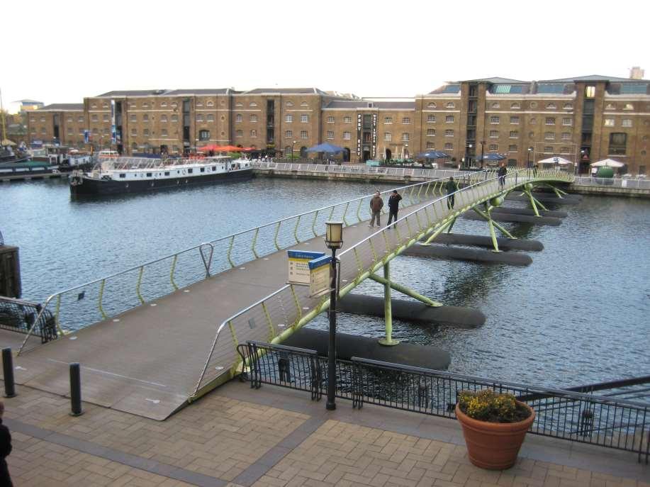
6 Canary Wharf: 1982
7 THE 1970s - A LOST DECADE Everyone knew that the old Port of London was progressively closing caused by the container revolution, and moving 15 miles down river; Many studies were carried out about possible forms of new development, but with no resulting action; Possibilities included developing waterside businessses and logisitics, exploiting waterside for recreation/parks, modern commercial and housing development; Elections and Government changes added to uncertainty and caused policy changes;
8 THE 1970s - A LOST DECADE A municipal led organisation was set up by Government. But this produced a backward looking development plan which attempted to revive business sectors which were in fact declining; Very little Government funding; General pessimism about the future of the London economy, population falling and many business sectors declining.

9 LDDC Boundaries 5000 acres
10 London Docklands Development Corporation Government agency with strong Government support, operated within defined geographical boundary, municipal services continued. Single minded, with specific targets - attracting private sector business investment, attracting jobs, promoting investment in homes both owner occupied and for rent, creating better local environment eg new parks. Infrastructure : utilities, roads, public transport, public realm Financed by Government to be infrastructure provider, not to be a developer/business investor itself. Limited time span, therefore LDDC had sense of urgency and speed.

11 Icons : Canary Wharf Docks

12 Light Railway

13 Experimental Landing
14

15 Riverside Walkway

16 Pumping Station

17 Canary Wharf 1992
18 Canary Wharf 2002


19 Transport Investment & Growth Land use integration Canary Wharf case study only : only ,000 workers workers remain remain the in the Docklands Docklands area Area 1987: Docklands : Light Light Railway Railway opens. opens, By by working working pop. approx. population 13,000 approx 13, : : Jubilee Jubilee Line Line Extension Extension opens. opens, Crossrail set set to open to open 2017, 2017, enabling further growth. By by 2006 working population pop. reaches reaches c 93,000 densities Working schemes population such as Wood to reach Wharf 200,000 working 93,000 provide demand for JLE c pop. to reach close to 200,000
20 Why Did Canary Wharf Happen? World economy grew fast in the 1980s, CW agreement with LDDC to develop signed in July 1987; The developer Olympia and York had very successful track record and good at raising construction finance; Rapid expansion of financial services sector; London needed modern large scale office buildings, most existing offices were old-fashioned; LDDC had development sites, supported large scale development, and was willing to provide much better transport infrastructure; Enterprise Zone and tax incentives

21 Cabot Square - Canary Wharf

22 Global City FBS to TMT?

23 Millharbour Isle of Dogs

24 Providence Wharf - Leamouth

25 Infrastructure Impacts

26 A Dividing Highway

27 Too Much Highway

28 East of Canary Wharf Sense of Place?

29 Docklands Royal Docks

30 Royal Docks

31 Royal Docks

32 Thames Gateway
33 CONCLUSIONS East London regeneration is continuing, long after LDDC closed down. Single minded regeneration organisations are essential to make fast progress. Government finance for infrastructure investment is essential to help create private sector investment confidence.. To ensure that local communities benefit from regeneration there must be cooperation between public and private bodies.
34 CONCLUSIONS The change from old to new business sectors requires careful support for local communities, especially training for the new job opportunities. High quality design of buildings and places and using basic features of the area ( light rail, water, docks, local history) help give the area a special character. Canary Wharf, and now the Olympics area, are symbols of the new East London, bringing confidence to the wider area.
The Changing Fortunes of London's Docklands
 The Changing Fortunes of London's Docklands - presentation by Stuart Innes Regeneration and Renewal Conference - Birmingham Wednesday 1 st April 2009 About Stuart Innes. 1961-1980: civil servant in the
What are the main characteristics of a CBD? next four slides?
 What are the main characteristics of a CBD? How many characteristics of a CBD can you spot in the How many characteristics of a CBD can you spot in the next four slides? The Tallest Buildings Why? What
Urban White Paper on Tokyo Metropolis 2002
 Urban White Paper on Tokyo Metropolis 2002 By Bureau of City Planning Tokyo Metropolitan Government Part I. "Progress in IT and City Building" Effects of computer networks on cities and cities' response
INVESTOR GUIDE. A development by
 INVESTOR GUIDE A development by Developer: LBS Properties & Xinyuan International Development name: Address: Developer: Local authority: Tenure: Building insurance: The Madison 199 207 Marsh Wall, London
LONDON DOCKLANDS REVISITED SUE BROWNILL
 LONDON DOCKLANDS REVISITED SUE BROWNILL An East London Water City for the 21st Century The LDDC in the 80s? No, New Labour in 2006 The Continuing Regeneration of Docklands THE CONTINUING REGENERATION OF
CLAREMONT MASTER PLAN 2017: LAND USE COMMUNITY INPUT
 Planning and Development Department 14 North Street Claremont, New Hampshire 03743 Ph: (603) 542-7008 Fax: (603) 542-7033 Email: cityplanner@claremontnh.com www.claremontnh.com CLAREMONT MASTER PLAN 2017:
Economic Geography of the Long Island Region
 Geography of Data Economic Geography of the Long Island Region Copyright 2011 AFG 1 The geography of economic activity requires: - the gathering of spatial data - the location of data geographically -
GIS Geographical Information Systems. GIS Management
 GIS Geographical Information Systems GIS Management Difficulties on establishing a GIS Funding GIS Determining Project Standards Data Gathering Map Development Recruiting GIS Professionals Educating Staff
CHAPTER 2. Strategic Context
 CHAPTER 2 Strategic Aim: To facilitate the future development of Cork as a national gateway city within the integrated land use and transportation framework set out in the Cork Area Strategic Plan 2001
Decline and redevelopment of industrial sites. Targeting the most needy places?
 Regional Studies Association Global Conference, Fortaleza 28-04-2014 Decline and redevelopment of industrial sites. Targeting the most needy places? Jasper Beekmans MSc Radboud University Nijmegen, The
High speed network in Hauts-de-France Region. Värnamo, 17 th May 2018
 High speed network in Hauts-de-France Region Värnamo, 17 th May 2018 Hauts-de-France at the crossroads of the North-West Europe High speed train approach in France In the 1980s: will to link the main cities
Chapter 12. Key Issue Three: Why do business services locate in large settlements?
 Chapter 12 Key Issue Three: Why do business services locate in large settlements? Business Services and Settlements World cities Ancient world cities Medieval world cities Modern world cities Hierarchy
Growing Lagging Regions:
 Growing Lagging Regions: Case study: North of England OECD seminar, June 28 2010 Richard Baker Policy & Research Manager, Northern Way richard.baker@thenorthernway.co.uk Presentation Address discussion
Measuring connectivity in London
 Measuring connectivity in London OECD, Paris 30 th October 2017 Simon Cooper TfL City Planning 1 Overview TfL Connectivity measures in TfL PTALs Travel time mapping Catchment analysis WebCAT Current and
East Bay BRT. Planning for Bus Rapid Transit
 East Bay BRT Planning for Bus Rapid Transit Regional Vision Draper Prison The Bottleneck is a State-Level issue, Salt Lake County 2050 Population: 1.5M Draper Prison hopefully with some State-Level funding!
The Use of Geographic Information Systems (GIS) by Local Governments. Giving municipal decision-makers the power to make better decisions
 by Local Governments. Giving municipal decision-makers the power to make better decisions") The Use of Geographic Information Systems (GIS) by Local Governments Giving municipal decision-makers the power to make better decisions Case Study: Examples of GIS Usage by Local Governments in North
The Use of Geographic Information Systems (GIS) by Local Governments Giving municipal decision-makers the power to make better decisions Case Study: Examples of GIS Usage by Local Governments in North
Edexcel Geography Advanced Paper 2
 Edexcel Geography Advanced Paper 2 SECTION B: SHAPING PLACES Assessment objectives AO1 Demonstrate knowledge and understanding of places, environments, concepts, processes, interactions and change, at
Why care about metropolitan and regional perspectives?
 Metropolitan challenges and solutions Why care about metropolitan and regional perspectives? Irma Karjalainen, Director, Helsinki Region Environmental Services Authority HSY, LUMAT Conference, 25 September
1The Many Uses of GIS
 1The Many Uses of GIS BUILDING EUROPEAN SPATIAL DATA INFRASTRUCTURES In April 2006, Esri president Jack Dangermond gave a presentation on the INSPIRE Directive at the European Union (EU) Interparliamentary
Experience and perspectives of using EU funds and other funding for the implementation of district renovation projects
 Experience and perspectives of using EU funds and other funding for the implementation of district renovation projects Ministry of the Interior of Lithuania Regional policy department Administration, coordination,
Sustainable Suburbs: Restructuring Suburban Development
 Sustainable Suburbs: Restructuring Suburban Development Stephen B. Friedman, AICP, CRE ULI Forum, October 8, 2009 The Vocabulary of Growth CAVE NIMBY BANANA NOTE NOPE NIMEY Triple Bottom Line Profitability
Exemplar for Internal Achievement Standard. Geography Level 2
 Exemplar for Internal Achievement Standard Geography Level 2 This exemplar supports assessment against: Achievement Standard 91241 Demonstrate geographic understanding of an urban pattern An annotated
Cultural Data in Planning and Economic Development. Chris Dwyer, RMC Research Sponsor: Rockefeller Foundation
 Cultural Data in Planning and Economic Development Chris Dwyer, RMC Research Sponsor: Rockefeller Foundation A Decade of Attempts to Quantify Arts and Culture Economic impact studies Community indicators
Making space for a more foundational construction sector in Brussels
 Making space for a more foundational construction sector in Brussels Sarah De Boeck, David Bassens & Michael Ryckewaert Social innovation in the Foundational Economy Cardiff, 5 th of September 2018 1.
Manchester City Region: The case for agglomeration economies. Steve Gibbons Henry Overman Alessandra Tucci
 Manchester City Region: The case for agglomeration economies Steve Gibbons Henry Overman Alessandra Tucci Objectives Explain agglomeration economies Review of existing evidence Primary evidence on role
Mapping Maine s Working Waterfront: for Our Heritage and Economy
 Mapping Maine s Working Waterfront: for Our Heritage and Economy Abstract Mapping Maine s Working Waterfronts is a collaborative project led by the Island Institute that inventories the state s current
The Mayor s Outer London Commission: Final Report
 The Mayor s Outer London Commission: Final Report Purpose of the Outer London Commission find out the extent to which outer London has potential to contribute to the economic success of London as a whole,
GIS Monroe Geographic Information System March 14, 2018
 GIS Monroe Geographic Information System March 14, 2018 Goals Maintain Enterprise/County-wide geo-database Increase spatial accuracy of data Build and acquire more data layers Increase use of GIS; as another
Sustainable tourism in for Sustaibale Danang
 Sustainable tourism in for Sustaibale Danang A case study of Balearic Ecotax in Spain toward Sustainable tourism Miki Yoshizumi Associate Professor College of Gastronomy Management Ritsumeikan University
Proposed Scope of Work Village of Farmingdale Downtown Farmingdale BOA Step 2 BOA Nomination Study / Draft Generic Environmental Impact Statement
 Proposed Scope of Work Village of Farmingdale Downtown Farmingdale BOA Step 2 BOA Nomination Study / Draft Generic Environmental Impact Statement The scope of work that follows incorporates and covers
Social Studies Grade 2 - Building a Society
 Social Studies Grade 2 - Building a Society Description The second grade curriculum provides students with a broad view of the political units around them, specifically their town, state, and country.
HORIZON 2030: Land Use & Transportation November 2005
 PROJECTS Land Use An important component of the Horizon transportation planning process involved reviewing the area s comprehensive land use plans to ensure consistency between them and the longrange transportation
Capital, Institutions and Urban Growth Systems
 Capital, Institutions and Urban Growth Systems Robert Huggins Centre for Economic Geography, School of Planning and Geography, Cardiff University Divergent Cities Conference, University of Cambridge, Cambridge
Dublin Chamber submission on Dublin City Development Plan : Outdoor Advertising Strategy
 Dublin Chamber submission on Dublin City Development Plan 2011 2017: Outdoor Advertising Strategy January 2012 Key Points: Sustainable and appropriate advertising can play an important positive role in
Crossrail Property Impact & Regeneration Study
 Crossrail Property Impact & Regeneration Study 2012 2026 1 Contents Executive Summary 4 1. Introduction & approach 12 2. What have others considered to be the impact? 16 3. Value, development pipeline
Port Cities Conference: How Regional Planning can Help Support a Competitive Port. Christina DeMarco Metro Vancouver
 Port Cities Conference: How Regional Planning can Help Support a Competitive Port Christina DeMarco Metro Vancouver June 12. 2008 Metro Vancouver Regional Growth Management Three ways to help support the
NATURE AND EXTENT OF PROPOSED DEVELOPMENT. Amount of Development Development Zones Distribution of Density Policies
 NATURE AND EXTENT OF PROPOSED DEVELOPMENT Amount of Development Development Zones Distribution of Density Policies DRAFT POOLBEG PLANNING SCHEME Amount of Development 78 4.1 The rationale for the overall
DRAFT PROGRAM Registration of participants, welcome coffee, exhibition tour
 DRAFT PROGRAM 20 Feb 2018 09.00-10.00 Registration of participants, welcome coffee, exhibition tour 10.00 12.00 ROUND TABLE: INTERNATIONAL COOPERATION IN THE ARCTIC PROJECTS: CHALLENGES AND OPPORTUNITIES
Towards a City Model for Heritage-Led Regeneration and Tourism Development
 Towards a City Model for Heritage-Led Regeneration and Tourism Development Brian Smith, Secretary General European Association of Historic Towns and Regions Summary of Presentation Objective Background
Population and Employment Forecast
 Population and Employment Forecast How Do We Get the Numbers? Thurston Regional Planning Council Technical Brief Updated July 2012 We plan for forecast growth in Population and Employment, but where do
Reports Show Economic Potential of New Maine National Park
 Elliotsville Plantation, Inc. 769 Congress St., Portland, Maine 04102 207-518-9462 CONTACT: David Farmer, (207) 557-5968, dfarmer@bernsteinshur.com Ben Alexander, (406) 599-7423, ben@headwaterseconmics.org
Data driven approaches to Urban Planning Experience from Derry/Londonderry
 Data driven approaches to Urban Planning Experience from Derry/Londonderry Anna Rose RTPI Belfast 11 th of September 1 June 26 07:47AM 2 The value of the City The space of the city is a theatre: playing
a) Imbedding flexibility b) Different incentives for different locations? 1. What are we trying to achieve?
 Imbedding flexibility b) Different incentives for different locations? 1. What are we trying to achieve?") 2 1. What are we trying to achieve? a) Growth as fast as possible (spatially neutral) b) Growth as fast as possible, in as many places as possible c) Shift in the pattern of geographic distribution of
2 1. What are we trying to achieve? a) Growth as fast as possible (spatially neutral) b) Growth as fast as possible, in as many places as possible c) Shift in the pattern of geographic distribution of
Integrated infrastructure planning at metropolitan scale. QII implementation metro-wide (horizontal and vertical coordination)
") Session 10: Working Across Political and Interjurisdictional Boundaries to Realize QII Mats Andersson Integrated infrastructure planning at metropolitan scale QII implementation metro-wide (horizontal
Session 10: Working Across Political and Interjurisdictional Boundaries to Realize QII Mats Andersson Integrated infrastructure planning at metropolitan scale QII implementation metro-wide (horizontal
National Spatial Development Perspective (NSDP) Policy Coordination and Advisory Service
 Policy Coordination and Advisory Service") National Spatial Development Perspective (NSDP) Policy Coordination and Advisory Service 1 BACKGROUND The advances made in the First Decade by far supersede the weaknesses. Yet, if all indicators were
National Spatial Development Perspective (NSDP) Policy Coordination and Advisory Service 1 BACKGROUND The advances made in the First Decade by far supersede the weaknesses. Yet, if all indicators were
The Governance of Land Use
 The planning system The Governance of Land Use United Kingdom Levels of government and their responsibilities The United Kingdom is a unitary state with three devolved governments in Northern Ireland,
Economic Development and Transport in New Zealand. Thomas Simonson 4/7/2016
 Economic Development and Transport in New Zealand Thomas Simonson 4/7/2016 Definitions > Economics is about people and communities, and the skills, equipment and resources they acquire to pursue their
Economic Activity Economic A ctivity
 5 Economic Economic Activity Activity ECONOMIC ACTIVITY 5.1 EMPLOYMENT... 5-7 5.1.1 OBJECTIVE... 5-7 5.1.2 POLICIES... 5-7 5.2 PROTECTING THE AREA OF EMPLOYMENT... 5-9 5.2.1 OBJECTIVE... 5-9 5.2.2 POLICIES...
New Partners for Smart Growth: Building Safe, Healthy, and Livable Communities Mayor Jay Williams, Youngstown OH
 New Partners for Smart Growth: Building Safe, Healthy, and Livable Communities Mayor Jay Williams, Youngstown OH The City of Youngstown Youngstown State University Urban Strategies Inc. Youngstown needed
Subject: Note on spatial issues in Urban South Africa From: Alain Bertaud Date: Oct 7, A. Spatial issues
 Page 1 of 6 Subject: Note on spatial issues in Urban South Africa From: Alain Bertaud Date: Oct 7, 2009 A. Spatial issues 1. Spatial issues and the South African economy Spatial concentration of economic
North and Central Asia: Overview and Recent Trends. Tiziana Bonapace Head Subregional Office for North and Central Asia, ESCAP
 North and Central Asia: Overview and Recent Trends Tiziana Bonapace Head Subregional Office for North and Central Asia, ESCAP North and Central Asia: An Idiosyncratic Setting High economic volatility After
T H I R T Y L O D G E R O A D L O N D O N N W 8 8 N T F R E E H O L D D E V E L O P M E N T O P P O R T U N I T Y
 T H I R T Y L O D G E R O A D L O N D O N N W 8 8 N T F R E E H O L D D E V E L O P M E N T O P P O R T U N I T Y 3 0 L O D G E R O A D L O N D O N N W 8 8 N T Oxford Street Marylebone Station Regent s
Vital city lively neighborhood living center
 From the ugliest place to heart of the suburb Vital city lively neighborhood living center Marja Straver - Nevalainen September 12 th, 2012 If you want to see the sun, t th look next to it to NL FI 10x
6 th GLOBAL SUMMIT ON URBAN TOURISM 4 6 December 2017, Kuala Lumpur (Malaysia)
") 6 th GLOBAL SUMMIT ON URBAN TOURISM 4 6 December 2017, Kuala Lumpur (Malaysia) SUMMARY/CONCLUSIONS Esencan TERZIBASOGLU Director Destination Management and Quality eterzibasoglu@unwto.org 6TH GLOBAL SUMMIT
6 th GLOBAL SUMMIT ON URBAN TOURISM 4 6 December 2017, Kuala Lumpur (Malaysia) SUMMARY/CONCLUSIONS Esencan TERZIBASOGLU Director Destination Management and Quality eterzibasoglu@unwto.org 6TH GLOBAL SUMMIT
An online data and consulting resource of THE UNIVERSITY OF TOLEDO THE JACK FORD URBAN AFFAIRS CENTER
 An online data and consulting resource of THE JACK FORD URBAN AFFAIRS CENTER THE CENTER FOR GEOGRAPHIC INFORMATION SCIENCE AND APPLIED GEOGRAPHICS DEPARTMENT OF GEOGRAPHY AND PLANNING THE UNIVERSITY OF
Regional collaboration & sharing: pathway to sustainable, just & inclusive cities in Europe
 Berlin s Environmental Justice Map Regional collaboration & sharing: pathway to sustainable, just & inclusive cities in Europe Dr. Andrea I Frank Cardiff University School of Geography & Planning A. Sustainability:
Urban Regeneration. edited by Peter Roberts Hugh Sykes Rachel Granger
 Urban Regeneration edited by Peter Roberts Hugh Sykes Rachel Granger 00_Roberts_et_al_Prelims.indd 3 9/1/2016 12:16:22 PM 1 Introduction Peter Roberts, Hugh Sykes and Rachel Granger In the introduction
1 Business Development
 1 Business Development Existing developed economy in this Euroregion, based on the position both municipalities (Ruse and Giurgiu) have in the national and regional economies of both countries Diverse
Planning for Economic and Job Growth
 Planning for Economic and Job Growth Mayors Innovation Project Winter 2012 Meeting January 21, 2012 Mary Kay Leonard Initiative for a Competitive Inner City AGENDA The Evolving Model for Urban Economic
Decision-making support tool for promotion policies of abandoned mine areas
 2013 Esri International User Conference July 8 12, 2013 San Diego, California Decision-making support tool for promotion policies of abandoned mine areas Son, Jin Seoul National University Esri UC2013.
c. What is the most distinctive above ground result of high land costs and intensive land use? i. Describe the vertical geography of a skyscraper?
 AP Human Geography Unit 7b Guided Reading: Urban Patterns and Social Issues Mr. Stepek Key Issue #1: Why Do Services Cluster Downtown? (Rubenstein p 404 410) 1. What is the CBD? What does it contain and
Outline. Tourism A Viable Option for Abandoned Mines?
 Tourism A Viable Option for Abandoned Mines? Pete Whitbread-Abrutat Post-Mining Alliance, Eden Project Outline Post-Mining Alliance Mining and tourism Aspects of mining and tourism Case studies Success
Recovery Renewal Rebuilding
 Recovery Renewal Rebuilding Federal Reserve Foreclosure Series Washington, D.C. October 20, 2008 Mayor Jay Williams, Youngstown OH The City of Youngstown Youngstown State University Urban Strategies Inc.
accessibility accessibility by-pass bid-rent curve bridging point administrative centre How easy or difficult a place is to reach.
 accessibility accessibility How easy or difficult a place is to reach. How easy or difficult it is to enter a building. administrative centre bid-rent curve The function of a town which is a centre for
Exploring GIS Potential for Northwestern Ontario Land Information Ontario
 Exploring GIS Potential for Northwestern Ontario Land Information Ontario May 13, 2015 The LIO Vision LIO Vision: That all geographic information about Ontario is fully integrated and accessible LIO Goal:
Too Close for Comfort
 Too Close for Comfort Overview South Carolina consists of urban, suburban, and rural communities. Students will utilize maps to label and describe the different land use classifications. Connection to
King City URA 6D Concept Plan
 King City URA 6D Concept Plan King City s Evolution Among the fastest growing cities 2000 Census 1,949 2010 Census 3,111 60% increase 2016 Census estimate 3,817 23% increase Average annual rate 4.3% Surpassing
Size matters: issues and challenges of local development with a special focus on small and medium sized towns in Czechia
 Size matters: issues and challenges of local development with a special focus on small and medium sized towns in Czechia Luděk Sýkora Charles University, Faculty of Science Dept. of Social Geography and
FROM INDUSTRY DEPENDENT URBAN AGGLOMERATION TO CONTEMPORARY METROPOLITAN AREA TOWARDS THE RENEWED LISBON STRATEGY
 FROM INDUSTRY DEPENDENT URBAN AGGLOMERATION TO CONTEMPORARY METROPOLITAN AREA TOWARDS THE RENEWED LISBON STRATEGY Tomasz Sławiński - architect Deputy Director Mazovian Office for Spatial Planning and Regional
The 3V Approach. Transforming the Urban Space through Transit Oriented Development. Gerald Ollivier Transport Cluster Leader World Bank Hub Singapore
 Transforming the Urban Space through Transit Oriented Development The 3V Approach Gerald Ollivier Transport Cluster Leader World Bank Hub Singapore MDTF on Sustainable Urbanization The China-World Bank
[Leveraging & Improving Neighborhood Connections] Area E Cedar Creek
![[Leveraging & Improving Neighborhood Connections] Area E Cedar Creek](/thumbs/86/93508963.jpg "[Leveraging & Improving Neighborhood Connections] Area E Cedar Creek") Community Charrette LINC Dallas [Leveraging & Improving Neighborhood Connections] Area E Cedar Creek 06.02.12 LINC Workshop Area E Area E has the unique distinction of at-grade frontage to the Trinity
Community Charrette LINC Dallas [Leveraging & Improving Neighborhood Connections] Area E Cedar Creek 06.02.12 LINC Workshop Area E Area E has the unique distinction of at-grade frontage to the Trinity
Ireland 2040 Our Plan. National Planning Framework
 Ireland 2040 Our Plan National Planning Framework Submission on behalf of Waterford City and County Council Waterford City SE Regional Economic Driver (2040) 1 INTRODUCTION The National Planning Framework
Functional territories in a eastern Norway and western Sweden perspective Armagh 16. November
 Functional territories in a eastern Norway and western Sweden perspective Armagh 16. November Dr. Bjørnar Sæther Professor in Human Geography Eastern Norway Research Institute (ENRI) University of Oslo
Science Unit Innovative Spaces
 Wuppertal für Arbeit Science Unit Innovative Spaces International Conference on Globalisation of Financial Services their Effects on Regional Development in Context of Spatial Innovation System and Cohesion
Vienna urban development - seestadt aspern as urban future lab
 Vienna urban development - seestadt aspern as urban future lab PERMACULTURE DESIGN COURSE * 2012 * ASPERN SEESTADT 1 Christof Schremmer, ÖIR Austrian Institute for Regional Studies and Spatial Planning
Lee County, Alabama 2015 Forecast Report Population, Housing and Commercial Demand
 Lee County, Alabama 2015 Forecast Report Population, Housing and Commercial Demand Thank you for purchasing this report, which contains forecasts of population growth, housing demand and demand for commercial
APPLICATION OF GIS IN COMPULSORY LAND ACQUISITION PROCESS. CASE STUDY: PARTS OF KAJIADO COUNTY SECTION OF THE STANDARD GAUGE RAILWAY
 APPLICATION OF GIS IN COMPULSORY LAND ACQUISITION PROCESS. CASE STUDY: PARTS OF KAJIADO COUNTY SECTION OF THE STANDARD GAUGE RAILWAY MUSYOKA SOLOMON NTHAMA F19/1456/2010 PROJECT SUPERVISOR : J.N. MWENDA
Forecasts for the Reston/Dulles Rail Corridor and Route 28 Corridor 2010 to 2050
 George Mason University Center for Regional Analysis Forecasts for the Reston/Dulles Rail Corridor and Route 28 Corridor 21 to 25 Prepared for the Fairfax County Department of Planning and Zoning Lisa
Lecture 9: Location Effects, Economic Geography and Regional Policy
 Lecture 9: Location Effects, Economic Geography and Regional Policy G. Di Bartolomeo Index, EU-25 = 100 < 30 30-50 50-75 75-100 100-125 >= 125 Canarias (E) Guadeloupe Martinique RÈunion (F) (F) (F) Guyane
Towards Reliable Spatial Database of Informal Areas in Greater Cairo Region
 KEYWORDS informal areas, unreliable spatial data, spatial data collecting, capacity building SUMMARY The uncontrolled and rapid increase of Egypt s cities is a major problem of the country. More than the
Crossrail 2. Michele Dix. June Transport for London
 Crossrail 2 Michele Dix June 2015 Transport for London London is growing by... new residents every hour That s a car load every minutes 2 Buses every day 2 Tube or or trains every week Today the population
Integrated Infrastructure Planning & Spatial Mapping
 Integrated Infrastructure Planning & Spatial Mapping Presenter: Heidi Dixon, Principal Social Planner, DTPLI 23 May 2014 PART 1 PLAN MELBOURNE : Metropolitan Planning Strategy PART 2 Case Study: DTPLI
Dar es Salaam - Reality Check Workshop
 Dar es Salaam - Reality Check Workshop hosted by GIZ and Dar es Salaam City Council Introduction: Key Urban Characteristics of Dar es Salaam Challenges and Opportunities for Resilient Development in the
Concept note. High-Level Seminar: Accelerating Sustainable Energy for All in Landlocked Developing Countries through Innovative Partnerships
 Concept note High-Level Seminar: Accelerating Sustainable Energy for All in Landlocked Developing Countries through Innovative Partnerships Date: 24 and 25 October 2016 Venue: Conference Room C3, Vienna
City of Johannesburg Department: Development Planning And Urban Management Development Planning and Facilitation
 City of Johannesburg Department: Development Planning And Urban Management Development Planning and Facilitation Marlboro Urban Development Framework: Discussion Document July 2007 1 Prepared for Department
Presentation by Thangavel Palanivel Senior Strategic Advisor and Chief Economist UNDP Regional Bureau for Asia-Pacific
 Presentation by Thangavel Palanivel Senior Strategic Advisor and Chief Economist UNDP Regional Bureau for Asia-Pacific The High-Level Euro-Asia Regional Meeting on Improving Cooperation on Transit, Trade
BIG IDEAS. Area of Learning: SOCIAL STUDIES Urban Studies Grade 12. Learning Standards. Curricular Competencies
 Area of Learning: SOCIAL STUDIES Urban Studies Grade 12 BIG IDEAS Urbanization is a critical force that shapes both human life and the planet. The historical development of cities has been shaped by geographic,
Urban Geography Unit Test (Version B)
") Urban Geography Unit Test (Version B) 1. What function do the majority of the world s ten most populated cities serve? a. a fortress city to resist foreign invasion b. a port city for transporting people
Urban Geography Unit Test (Version B) 1. What function do the majority of the world s ten most populated cities serve? a. a fortress city to resist foreign invasion b. a port city for transporting people
Study Overview. the nassau hub study. The Nassau Hub
 Livable Communities through Sustainable Transportation the nassau hub study AlternativeS analysis / environmental impact statement The Nassau Hub Study Overview Nassau County has initiated the preparation
The Analysis of Economic Development and Resilience Dynamics of Medium-Sized Towns
 Master Thesis Student: Ksenija Banovac Thesis supervisor: prof. Abdelillah Hamdouch, University François Rabelais, Tours The Analysis of Economic Development and Resilience Dynamics of Medium-Sized Towns
EDUQAS A LEVEL GEOGRAPHY
 EDUQAS A LEVEL GEOGRAPHY WJ-eC eduqas Specimen Assessment Materials - Component 1 Marked Student Responses The following booklet is compiled from student responses to questions from the Specimen Assessment
World Bank Group GEF Program
 World Bank Group GEF Program Global Environment Facility: -Transport World Bank GEF Coordination Team Content How does GEF work? World Bank s role in the GEF partnership The GEF transport activities What
Opportunities and challenges of HCMC in the process of development
 Opportunities and challenges of HCMC in the process of development Lê Văn Thành HIDS HCMC, Sept. 16-17, 2009 Contents The city starting point Achievement and difficulties Development perspective and goals
Dark Sky Initiative Draft Terms of Reference
 Dark Sky Initiative Draft Terms of Reference July 2008 Table of Contents 1.0 Introduction 2 2.0 Initiative intent 2-3 3.0 Initiative goals 3 4.0 Legislation 3 5.0 Municipal Development Plan 3 6.0 Land
Floods 2014 a wake up call to natural hazards
 Floods 2014 a wake up call to natural hazards Floods affected 119 municipalities (out of 165) 22% of total population affected by floods More than 30 municipalities sustained extensive damage 57 lives
Agglomeration Programme Switzerland: Integrated Planning by Balancing Transport and Urban Development IFHP Congress, Singapore
 Agglomeration Programme Switzerland: Integrated Planning by Balancing Transport and Urban Development IFHP Congress, Singapore May 30, 2014 Susanne Fischer, Head of Regional Planning, Department of Public
LOCATIONAL PREFERENCES OF FDI FIRMS IN TURKEY
 LOCATIONAL PREFERENCES OF FDI FIRMS IN TURKEY Prof. Dr. Lale BERKÖZ Assist. Prof. Dr.S. SenceTÜRK I.T.U. Faculty of Architecture Istanbul/TURKEY E-mail: lberkoz@itu.edu.tr INTRODUCTION Foreign direct investment
Experiences of public-private partnerships in the Euromediterranean relations and in the Po Valley, promoting a more balanced European territory
 Experiences of public-private partnerships in the Euromediterranean relations and in the Po Valley, promoting a more balanced European territory Claudio Tolomelli PolyMetrexPlus project s objectives To
ORIENT TRANSPORT COMPANY
 ORIENT TRANSPORT COMPANY (ESTABLISHED:1950) P R O FII L E:: ORIENT TRANSPORT COMPANY 14/2 OLD CHINA BAZAAR STREET, ROOM NO: 178,179,190,191 & 110. KOLKATA 700001. PHONE: (33) 22424690,22100389 FAX: (33)
NOAA Surface Weather Program
 NOAA Surface Weather Program Maintenance Decision Support System Stakeholder Meeting #9 Jim O Sullivan NOAA Surface Weather Program Manager NWS Office of Climate, Water, and Weather Services September