Megalopolis: An Assay for the Identification of the World Urban Mega-structures
|
|
|
- Theodore Holmes
- 5 years ago
- Views:
Transcription


1 55th Congress Megalopolis: An Assay for the Identification of the World Urban Mega-structures ARELLANO, Blanca & ROCA, Josep Lisbon, Portugal August 27th of 2015
 to")
 and the endless growth of the peripheries")

, the desurbanization of Leo van der Berg (1982),")
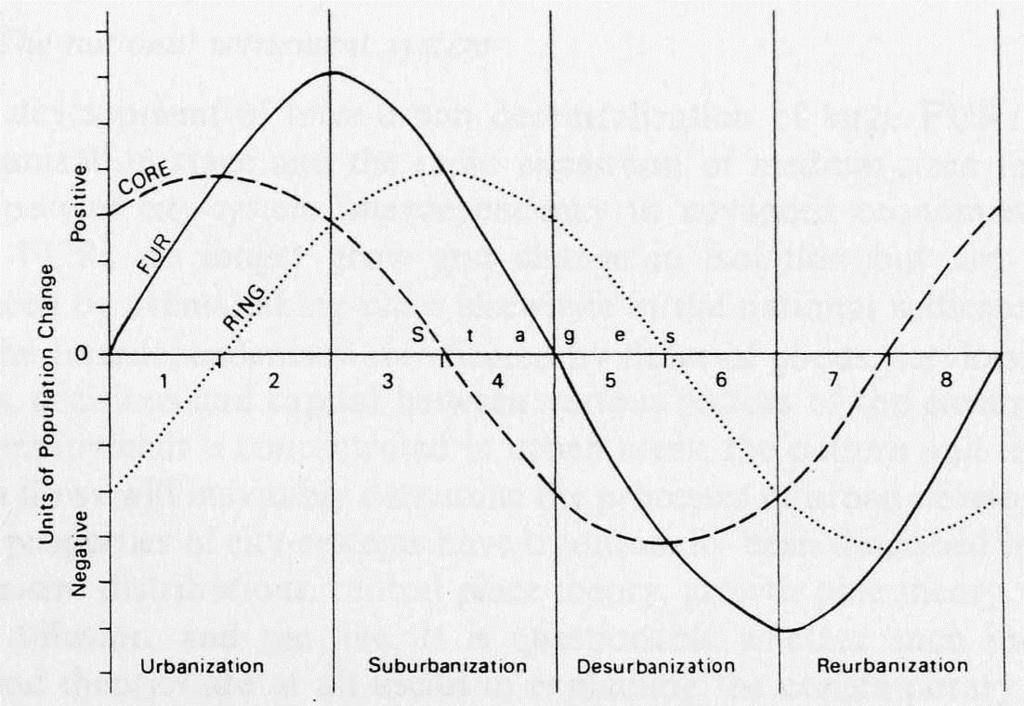
2 The 20th Century. Century of the urbanization From suburbanization (end of the XIX Century) to metropolitanization The worldwide spread of the automobile, improving communication infrastructures (road networks) and the endless growth of the peripheries (peri-urbanization) brought the generalization of urban sprawl The extension of the urbanization process to the developing world: a change in the geography of the urbanized world The oil crisis and changing production model of Fordism The counter-urbanization of Berry (1976), the desurbanization of Leo van der Berg (1982), the sprawling city of Indovina (1990), rurbanization, etc. A crisis of urbanization in the last quarter century?
3 Desurbanization or.

4 change in the geography of the urbanized world?
5 The concept of megalopolis Geddes In 1915, in Cities in evolution, Geddes anticipated the concept of megalopolis: The expectation is not absurd that the not very distant future will see practically one vast city-line along the Atlantic Coast for five hundred miles, and stretching back at many points; with a total of... many millions of population Geddes used the term conurbation to refer to the future city, but in a previous work, in 1904, he had already suggested the term megalopolis. Mumford Mumford was the first to use the term 'megalopolis' repeatedly. The 4th chapter of The Culture of Cities (1938), for example, is titled 'The rise and fall of Megalopolis' and he develops his thesis on the six stages of urban development: from the 'Eopolis' (village) to the 'polis' (association of villages) thereof to the 'Metropolis' (the capital city emerges), the 'megalopolis' ('the beginning of the decline'), the 'tyrannopolis' (the overexpansion of the urban system based on economic exploitation) and finally to the 'Nekropolis' (war and famine, city abandoned)
6 The concept of Megalopolis Gottmann It is certainly Gottmann (1957, 1961) to whom we owe the original work on the change of scale occurred in the urbanization. Gottmann in his book Megalopolis: The Urbanized Northeastern Seaboard of the United States, opened the systematic study of urban mega-regions. In the words of Gottmann: In 1950, on the basis of the new census, the Bureau of the Census prepared a map, later published as an illustration to a booklet of statistics on State Economic Areas, which showed clearly the continuity of an area of "metropolitan" economy from a little north of Boston to a little south of Washington ( ). This seemed to be a first statistical demonstration on the map of the existence of a continuous stretch of urban and suburban areas, the main NE-SW axis of which was about 600 miles long, and within the frame of which dwelt even in 1950 some 30 million people. ( )The supermetropolitan character of this vast area, the greatest such growth ever observed, called for a special name. We chose the word Megalopolis, of Greek origin
7 The concept of megalopolis: a complex and polemic concept Peter Hall (1973) A physical and functional reality or an analysis tool? P. Hall recognized that only five superstructures on a global scale deserve the name of megacities: Northeastern Urban Complex (the east coast of the United States), Great Lakes (Chicago, Detroit and Cleveland), The Japanese Megalopolis (Tokyo, Yokohama, Nagoya and Osaka -Kobe), The North-West European Megalopolis (the Randstat and the Rhine-Ruhr), The area called England Megalopolis Phenomenon, all of them in the developed world
8 Identification of Megalopolis First approach: geographical and functional approach Gottmann His approach was functional, qualitative, as juxtaposition of metropolitan areas (which came as defined by the Census functional areas of daily commuting residence / work). The notion of contact, coalescence and overlap (Clawson, 1971; Hall et al, 1973) functional metropolitan areas, is therefore the primary factor that allows identification of Megalopolis
, updated the work of Gottmann through the consideration of the Urbanized Areas of the USA Census Bureau, which shows the evolution of the megalopolis of Boston-Washington")
9 Definition of Megalopolis Second approach to the definition of megalopolis is the analysis of the spatial patterns of density of the human settlements. Morrill Morrill (2006), updated the work of Gottmann through the consideration of the Urbanized Areas of the USA Census Bureau, which shows the evolution of the megalopolis of Boston-Washington between 1950 and The work allows to see how the criterion density is not an efficient mechanism for defining megacities. Not only because of the discontinuity of densely populated areas, but the proliferation from the 70's of the phenomenon of ex-urban sprawl. Urbanized Areas in Boston-Washington Megalopolis (Morrill, 2006)

10 Definition of Megalopolis The third of the methodologies developed in the literature is the morphological approach, which emphasizes continuity of development, materialized mainly from structural axes of communication. Florida This methodology is inspired by the first criteria that were developed for the definition of the urban phenomenon in the era of metropolitan growth. Conurbations, once gone beyond the administrative borders of the central city, came to be defined under strictly physical criteria. Contiguity of urban growth is presented as well as the decisive factor for the distinction between the city and its rural surroundings.
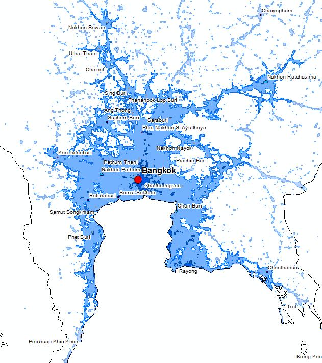
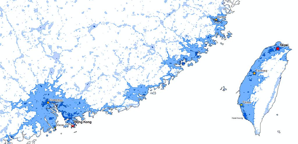
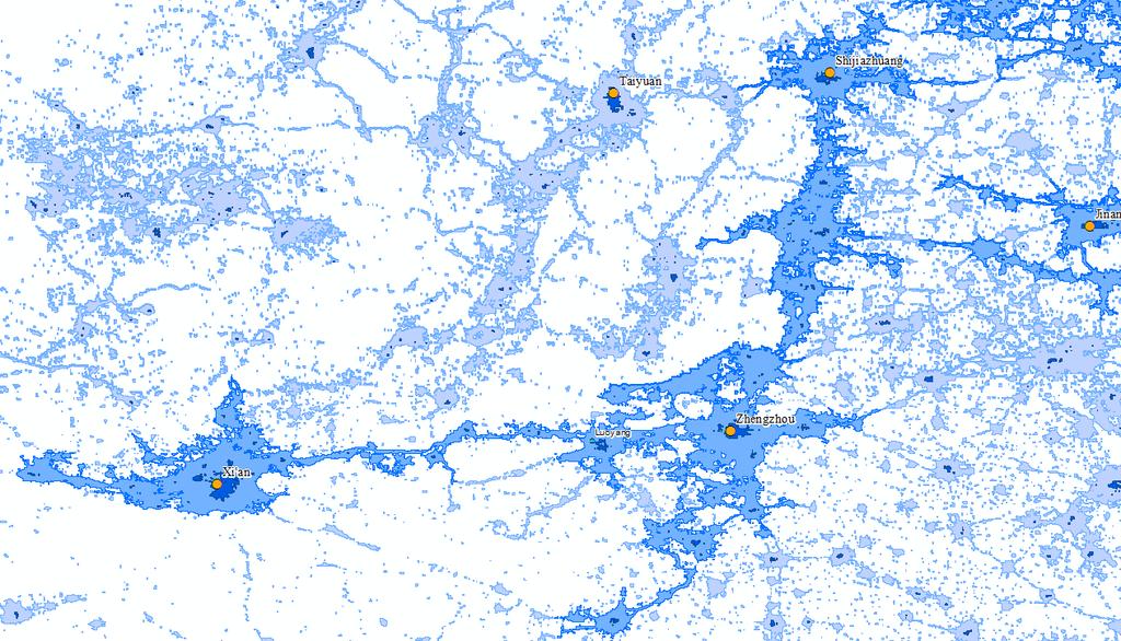
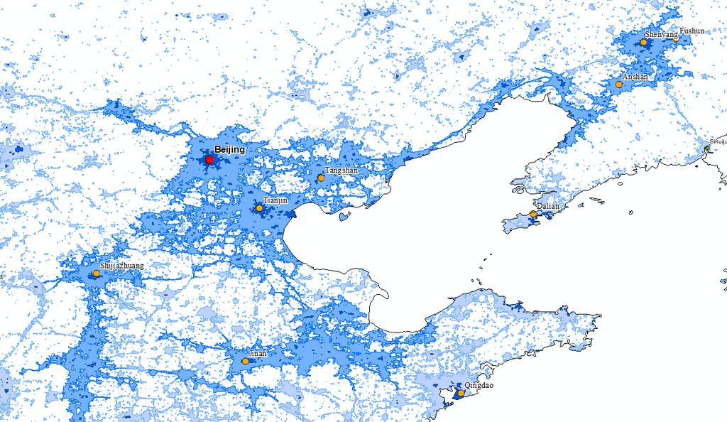
11 Megalopolis

12 Megalopolis The fourth approach is a qualitative approach based on local knowledge This approach, which is certainly the most used in the literature, does not respond to specific quantitative methodology, but responds to an intuitive vision, based on the professional knowledge of urban planners. From this approach, the Lincoln Institute of Land Policy, together with the Regional Planning Association and the Pennsylvania School of Design, developed in 2004, the proposal called Toward an America Spatial Development Perspective, which proposed a qualitative change in the territorial management of United States that exceeds the merely local (place, county) and even metropolitan proposing megalopolis as basic territorial ambit of planning.

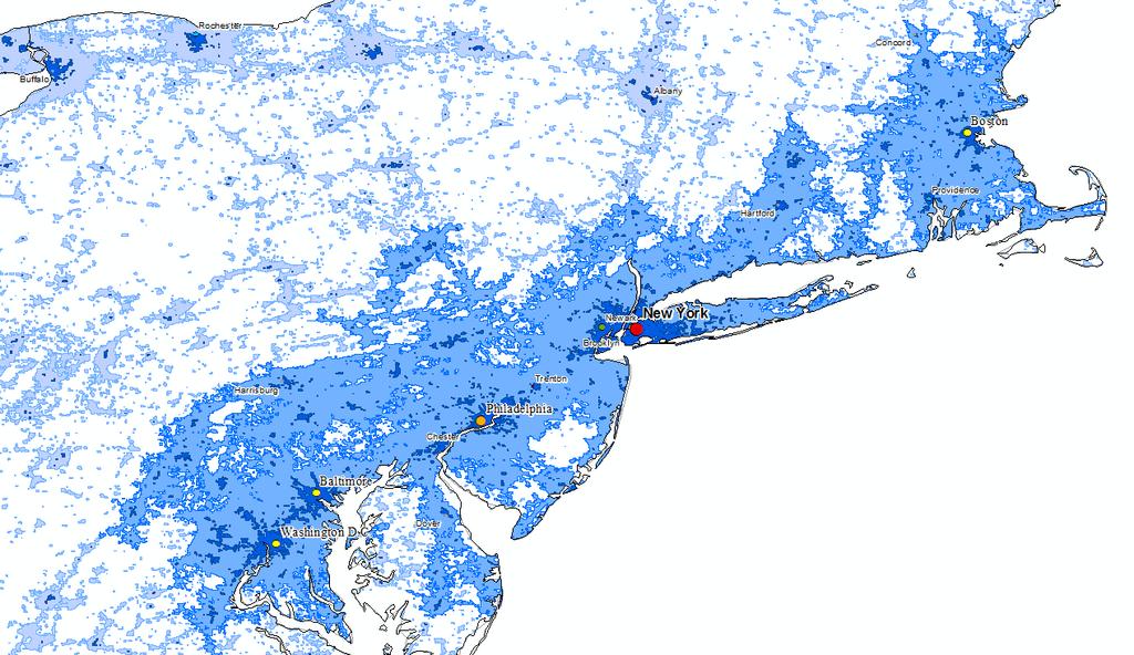
13 Our Methodology The present study parts from the satellite images, especially those derived from the night lights, represents the most useful contribution to the delimitation of megalopolis. The delimitation of the megalopolis on a global scale has been made by analyzing the image of night lights that in 2013 NASA has published and called Black Marble This new image of the Earth at night is a composite assembled from data acquired by the Suomi National Polar-orbiting Partnership (Suomi NPP) satellite over nine days in April 2012 and thirteen days in October 2012.

14 Methodology First: we analyzed the file supplied by NASA, which offers, in the visible spectrum, three images (RGB) differentiated from night lights. Then we to proceed to the composition of a single image in conventional greyscale palette (0-255)

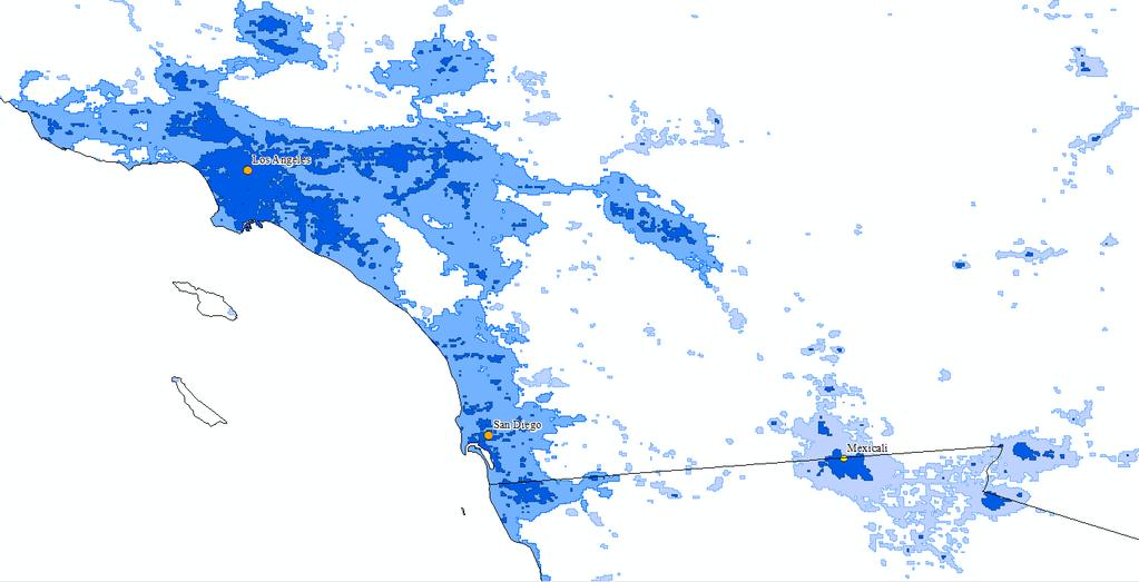
15 Methodology Nighttime light intensity outline. Los Angeles-San Diego-Tijuana Area Second: The image conversion from greyscale to elevations allows developing contours at different intensity levels, capable of identifying different hypothesis of global cities. In this regard, we ve been tried different alternatives, which have led to adopt the level curve on the intensity 64 (¼ of the light intensities analyzed 256). Source: Self prepared from NASA (2013).

16 Methodology This light intensity (64 of 256) allows a better identification of megalopolitan structures than alternative thresholds. For example, the intensity of light reflected by the ice at the poles is around 40, and very close to the light intensity of 38 is the reflection of the sandy deserts The analysis of these results, contrasted from the local knowledge has led to consider the threshold of 64 the best for the delimitation of the global megalopolis Source: Self prepared from NASA (2013).
 and New York (in red).")
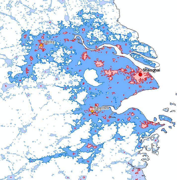
17 Methodology The contours of light (2012) with intensity equal to or greater than 64 have allowed to identify the lighted urban continuum, which have been aggregated into larger structures when there contiguity per vertex, or separation of one pixel at most, as can be seen in the image, where the agglomerations are shown, Boston (in white) and New York (in red). Boston (in white) and New York (in red) Source: Self prepared from NASA (2013).
 of the LandScan database developed by the Oak Ridge National Laboratory, USA.")
18 Methodology Spatial distribution of the human population for Calcutta Finally, we ve estimated the population of the continuing intensity contours of 64 or higher by overlapping the information of population (2008) of the LandScan database developed by the Oak Ridge National Laboratory, USA. LandScan allows to analyze the population structure of different environments in the urbanized planet, with a close approximation to the reality Source: Self prepared from LandScan (2008).
.")
19 Methodology Overlapping of the illuminated contours (64) and LandScan database for Calcutta Overlapping the lighted contours with intensity of 64 and the LandScan database has allowed to calculate the population of the same area, identifying planetary megalopolis ( ). Source: Self prepared from LandScan (2008).
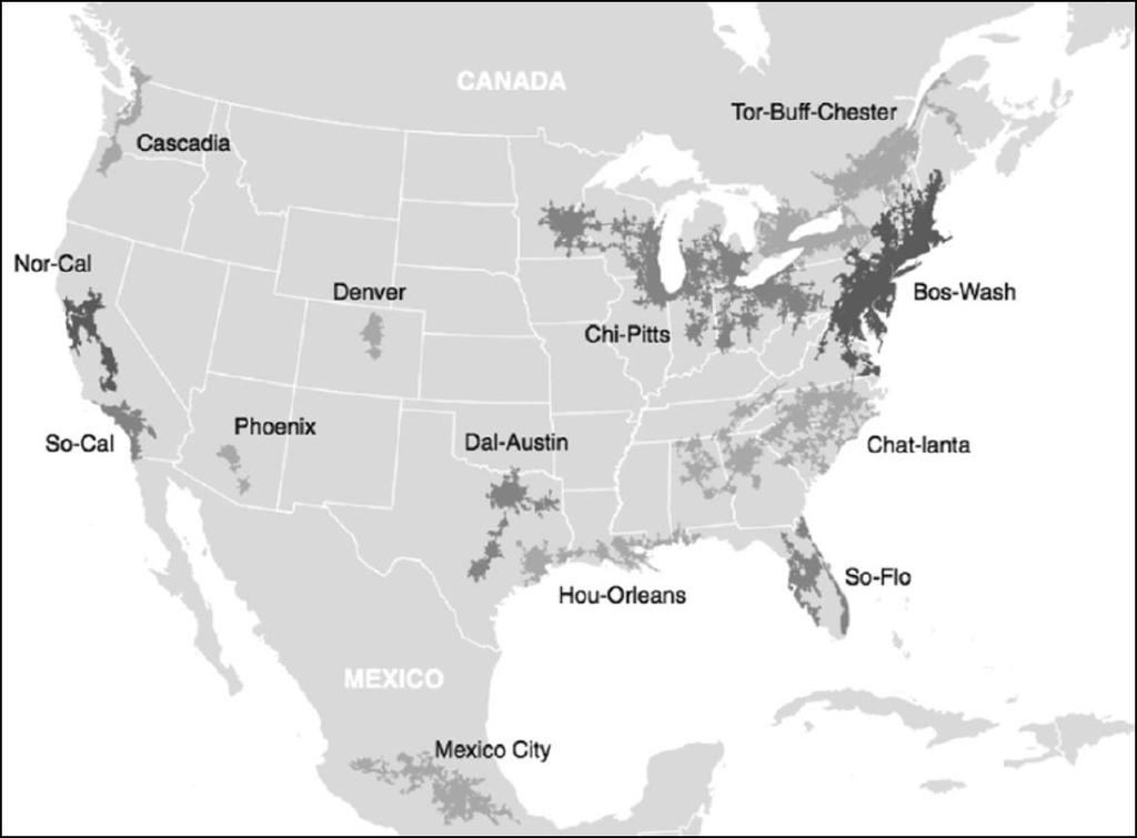
20 Results Following the work begun by Florida et al (2008), using the methodology of nighttime satellite images as a method for the delimitation of the megalopolis, our analysis allows: The worldwide identification of 444,502 populated areas illuminated with sufficient intensity (64 on a scale of 256) for consideration of urban nature. 433 of these illuminated areas reach a population of over one million inhabitants, concentrating 2,537 million inhabitants, 37.8% of the population of the planet. 92 over 5 million represent the seeds of megalopolitan structures. And 30 structures, that we call proto-megas, exceed 15 million, reaching a population of 1,298,757,300 inhabitants, placing as strong candidates to be characterized as megalopolis. Population (intensity 64) Frequency Percentage Accumulate > ,005, ,005, ,010, ,077, / ,082, ,523, ,552 1, ,773 4, ,783 6, ,904 19, ,142 49,9 < , TOTAL
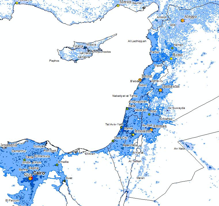
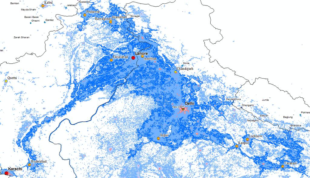
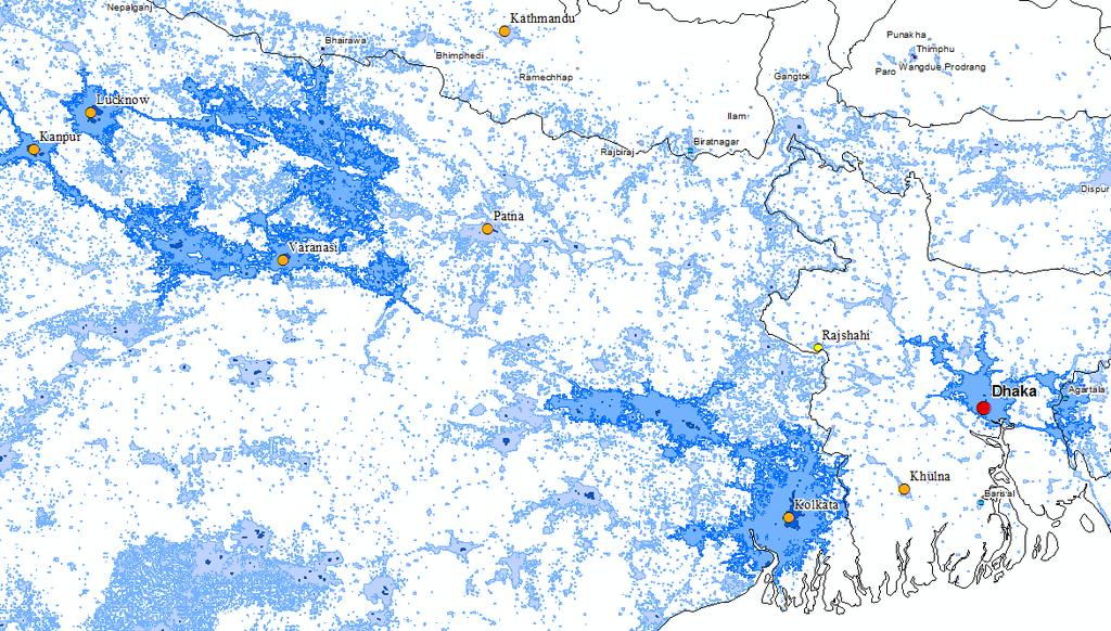
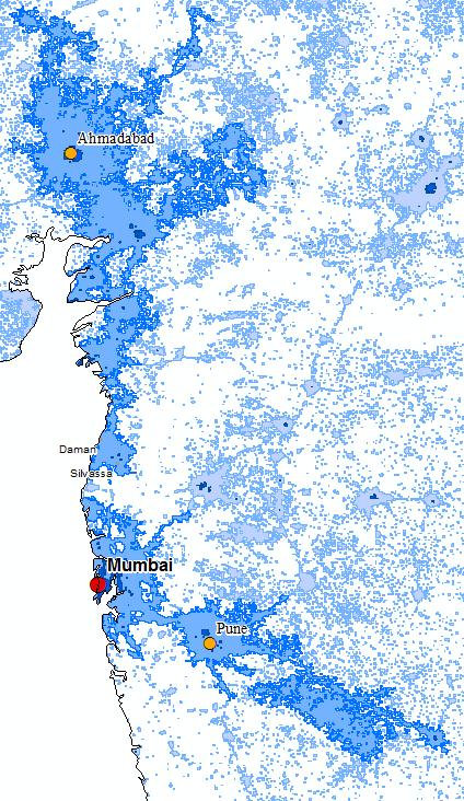
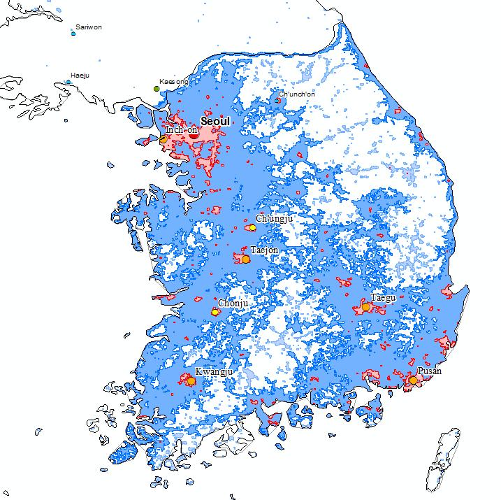
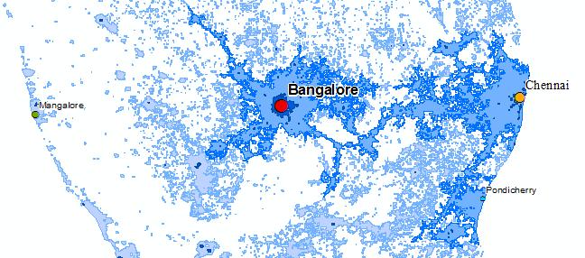
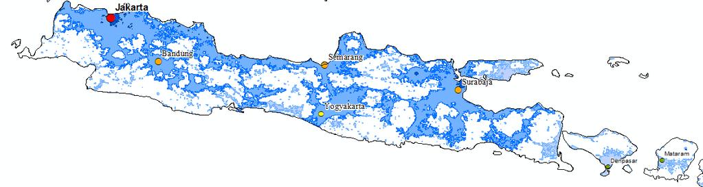
21 Results 26 megacities with a population exceeding 20 million, concentrating 1,374,291,094 people in their environment. These megalopolis are distributed throughout the entire planet. Asia highlights the presence of 18 large agglomerations: 2 transnational (India-Pakistan and India-Bangladesh), 5 in India, 6 in China (5 in the continent and one in Taiwan), and 1 in Japan, Indonesia, Korea, Philippines and the Middle East. America (4 megalopolis) Europe (3 agglomerations) Source: Self prepared from LandScan (2008). Africa (1 agglomeration) It demonstrates the global extent of the geography of the megalopolis. Only Oceania is free of such urban agglomerations.

22 Megalopolis Population Area Indian-Pakistani ,48 Java Island ,43 Yang Tse Delta ,58 Hokaido ,03 Nil River ,61 Beijing ,85 Central Europe ,48 Zhengzhou-Xian ,40 Pearl River ,41 NY-Boston-Washington ,18 South Korea ,30 Calcutta ,73 Uttar Pradesh ,07 England ,51 Mexico ,74 Mumbai ,50 Sao Paulo ,76 Bangalore-Chennai ,51 Med Orient ,57 Coast of Fujian ,38 North Italy ,22 Ahmedabad-Silvassa ,59 Source: Self prepared from LandScan (2008). Manila ,99 West Taiwan ,67 South California ,49 Dhaka ,48


23 Results Six megalopolis stand out for its extraordinary population size, with a population exceeding 75 million. These megalopolis are what might be called the premier league of world urban agglomerations. All of them located in Asia, with the exception of an African: the Indian-Pakistani, Java Island, Yangtze Delta, the island of Hokkaido, the Nile and Beijing agglomeration. No European or American megalopolis between these giants.

, does not appear until the tenth place ranking, preceded by the two large Chinese")
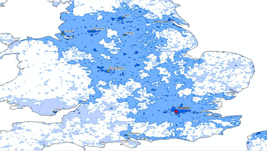
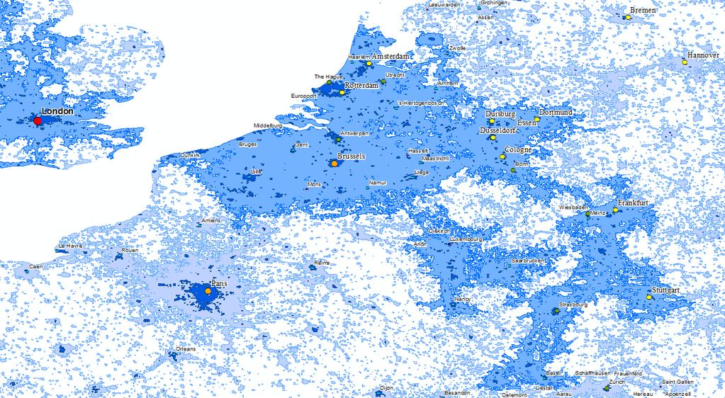
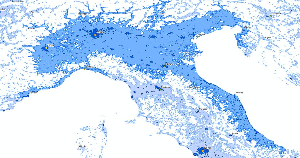
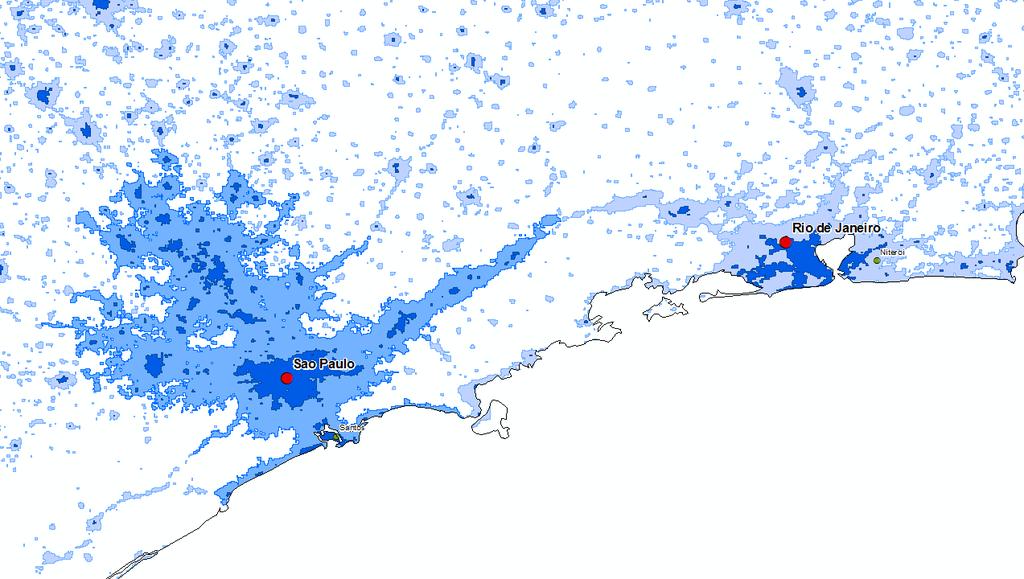
24 Results The large conurbation of Central Europe, which stretches from Brussels Dutch Randstad, the Rhine-Ruhr, Strasbourg and Stuttgart. London to Cardiff and Bristol Birmingham, Sheffield, Manchester, Liverpool and Leeds, on the fourteenth place, The vast agglomeration of northern Italy, which It extends from Milan to Venice, in the twenty-first. The American megalopolis par excellence, the US Northeast (Boston - New York - Philadelphia - Baltimore - Washington), does not appear until the tenth place ranking, preceded by the two large Chinese structures Zhengzhou- Pearl River Xian. The rest of American megalopolis is reduced to other giant, the large urban agglomeration around Mexico City, which only appears in the fifteenth place, Sao Paulo - Santos, on seventeenth Los Angeles - San Diego - Tijuana (Southern California), which is the penultimate of the 26 megacities obtained in the present study Southern CA; Source: Self prepared from NASA-NOAA (2012) and LandScan (2008).
25
26
27
28
29
30
31
32
33
34

35
36
37
38
39
40
41
42
43
44
45
46
47 Conclusions We can concluded that megacities are a new form of urban settlement that affects the entire planet This fact is not a phenomenon exclusive of the first world versus what the pioneering work of Geddes, Mumford and Gottmann seemed to suggest Latin America, Africa and especially Asia, are also protagonists of these new forms of occupation of space Emerging urban territories seem to make out a new economic and social order in Europe North America will no longer have the unique role of protagonists

48 Thanks for your attention! ARELLANO, Blanca & ROCA, Josep
2/25/2019. Taking the northern and southern hemispheres together, on average the world s population lives 24 degrees from the equator.
 Where is the world s population? Roughly 88 percent of the world s population lives in the Northern Hemisphere, with about half north of 27 degrees north Taking the northern and southern hemispheres together,
Population And Settlement Part I
 Population And Settlement Part I 0011 0010 1010 1101 0001 0100 1011 4 12 Think of the earth as a living organism that is being attacked by billions of bacteria whose numbers double every forty years. Either
What do we think of our cities?
 What do we think of our cities? Do we think of cities as beautiful places? Are cities healthy places to live? Do most of the world s people live in cities? Do cities function like other natural systems,
Urbanisation & Economic Geography (2)
") GEOG1101: Introduction to Economic Geography Tuesday 20 October, 2009 Urbanisation & Economic Geography (2) Kevon Rhiney Department of Geography and Geology University of the West Indies, Mona Lecture
GEOG1101: Introduction to Economic Geography Tuesday 20 October, 2009 Urbanisation & Economic Geography (2) Kevon Rhiney Department of Geography and Geology University of the West Indies, Mona Lecture
By Geri Flanary To accompany AP Human Geography: A Study Guide 3 rd edition By Ethel Wood
 Session 1 By Geri Flanary To accompany AP Human Geography: A Study Guide 3 rd edition By Ethel Wood WHAT IS DEMOGRAPHY? It is the scientific or statistical study of population. It comes from the Greek
9/19/2018. Dr. Hoch. RGPL 103 Global Cities: Planning and Development.
 Dr. Hoch RGPL 103 Global Cities: Planning and Development Dr. Hoch Email: rhoch@iup.edu 1 2 Earth s Orbit Around Sun Aphelion July 6 (12:00) Perihelion Jan 3 (00:00) EARTH 152.5 Million Km 147.5 Mil. Km
Migration and Urban Decay
 Migration and Urban Decay Asian Experiences Shekhar Mukherji RAWAT PUBLICATIONS Jaipur New Delhi Bangalore Mumbai Contents Preface List of Tables List of Figures ix xv xix Introduction 1 Very Crucial Urban
TYPES OF GOVERNMENTS
 While the terms country, state, and nation are often used interchangeably, there is a difference. A State (note the capital "S") is a self-governing political entity. The term State can be used interchangeably
Human Geography. Urban Development. Urban Development. Urban Development. Unit 8: Urban Development. I. Why are Settlements Established?
 I. Why are Settlements Established? A. Rural Settlements B. Urban Settlements Human Geography Unit 8: I. Why are Settlements Established? C. REASONS FOR ESTABLLISHING SETTLEMENTS 1. Cultural Religious
SDI Developments in the World s Currently Existing Mega Cities
 SDI Developments in the World s Currently Existing Mega Cities Silke Boos and Hartmut Müller FIG Working Week 2009 Surveyors Key Role in Accelerated Development, Eilat, Israel, 3-8 May 2009 TS 1B SDI in
Population distribution
 Population distribution Ernesto F. L. Amaral December 5, 2018 Population and Society (SOCI 312) Outline Introduction World population distribution Residential distribution and urbanization Economic distribution
Urbanisation Dynamics in West Africa AFRICAPOLIS I, 2015 UPDATE
 Public Disclosure Authorized Public Disclosure Authorized Urbanisation Dynamics in West Africa 1950 2010 AFRICAPOLIS I, 2015 UPDATE uy François Moriconi-Ebrard, Dominique Harre, Philipp Heinrigs Washington
Cities, Countries, and Population
 Cities, Countries, and Population After the world industrialized, better food, improved sanitation, and new medicines caused the world population to soar. To understand how heavily populated an area is,
Governance from megalopolis to the megaregion
 Governance from megalopolis to the megaregion A world of cities or planetary urbanization? David Wachsmuth School of Urban Planning, McGill University July 26, 2016 Urban thinking (and governance) beyond
DEFINING AND MEASURING WORLD-METRO REGIONS FOR INTERNATIONAL COMPARISONS
 DEFINING AND MEASURING WORLD-METRO REGIONS FOR INTERNATIONAL COMPARISONS Mario Piacentini, OECD 27th Scorus Conference, 11-13 August 2010, Latvia Why we need comparable measures of city performance Growing
Name Date Period Barron s (6 th edition) Chapter 7 Urban Geography
 Chapter 7 Urban Geography") Name Date Period Barron s (6 th edition) Chapter 7 Urban Geography Historical Geography of Urban Environments 1. In what way did the development of different types of occupations (carpenters, merchants,
Name Date Period Barron s (6 th edition) Chapter 7 Urban Geography Historical Geography of Urban Environments 1. In what way did the development of different types of occupations (carpenters, merchants,
Operational Definitions of Urban, Rural and Urban Agglomeration for Monitoring Human Settlements
 Operational Definitions of Urban, Rural and Urban Agglomeration for Monitoring Human Settlements By Markandey Rai United Nations Human Settlements Programme PO Box-30030 Nairobi, Kenya Abstract The United
Uchiyama, Yuta & Okabe, Akiko Categorization of 48 Mega-Regions by Spatial Patterns of Population Distribution 48 th ISOCARP Congress 2012
 Categorization of 48 Mega-Regions by Spatial Patterns of Population Distribution: The Relationship between Spatial Patterns and Population Change Comparative Study of Mega-regions: Toward a Dynamic Observation
Chapter 13 Study Guide: Urban Geography Cities in the periphery, Latin America, and Europe
 Chapter 13 Study Guide: Urban Geography Cities in the periphery, Latin America, and Europe Compared to the private automobile, public transportation offers more energy efficiency. Public transit is more
World Renaissance: Changing roles for people and places 55th Congress. Metropolitan Sprawl
 55th Congress Metropolitan Sprawl ARELLANO, Blanca & ROCA, Josep blanca.arellano@upc.edu, josep.roca@upc.edu http://www.upc.edu/cpsv/ Lisbon, Portugal August 27th of 2015 Urbanization and Sprawl The gradual
Identifying Megaregions in the US: Implications for Infrastructure Investment
 7. 10. 2 0 08 Identifying Megaregions in the US: Implications for Infrastructure Investment Dr. Myungje Woo Dr. Catherine L. Ross Jason Barringer Harry West Jessica Lynn Harbour Doyle Center for Quality
23TGEO 220 COURSE OUTLINE. Prerequisites: None. Course Description:
 Lecture 23TGEO 220 23TWorld Regional Geography Revised: Fall 2015 COURSE OUTLINE Prerequisites: None Course Description: Studies physical and cultural characteristics of selected geographical regions of
Alleghany County Schools Curriculum Guide GRADE/COURSE: World Geography
 GRADE/COURSE: World 2013-14 GRADING PERIOD: 1 st Six Weeks Time Frame Unit/SOLs SOL # Strand Resource Assessment 8 days* The student will use maps, globes, satellite images, photographs, or diagrams to
URBAN DETECTION, DELIMITATION AND MORPHOLOGY: COMPARATIVE ANALYSIS OF SELECTIVE MEGACITIES
 URBAN DETECTION, DELIMITATION AND MORPHOLOGY: COMPARATIVE ANALYSIS OF SELECTIVE MEGACITIES B.E. Arellano a, J. Roca a, B. Alhaddad a a CPSV, Centre of Land Policy and Valuations, Polytechnic University
2. What characteristics of population are important to demography? 3. Describe what overpopulation looks like at a local or regional level.
 Ch. 2: Population Name: Introduction & Case Study (p. 44-47) 1. Why is the study of population so critical? 2. What characteristics of population are important to demography? 3. Describe what overpopulation
Central Valley School District Social Studies Curriculum Map Grade 7. August - September
 August - September Geographical/Historical Skills Identify and analyze timelines. Construct and use cause and effect charts. Differentiate between fact and opinion. Use of word webs, flip charts, outlines
Chapter 21 Southwest Asia: Harsh & Arid Lands
 Name Hour Chapter 21 Southwest Asia: Harsh & Arid Lands Essential Question: How has the physical geography of Asia influenced the development of these regions (i.e. history, population distribution, &
Urban Expansion. Urban Expansion: a global phenomenon with local causes? Stephen Sheppard Williams College
 Urban Expansion: a global phenomenon with local causes? Stephen Sheppard Williams College Presentation for World Bank, April 30, 2007 Presentations and papers available at http://www.williams.edu/economics/urbangrowth/homepage.htm
São Paulo Metropolis and Macrometropolis - territories and dynamics of a recent urban transition
 São Paulo Metropolis and Macrometropolis - territories and dynamics of a recent urban transition Faculty of Architecture and Urbanism of São Paulo University Prof. Dr. Regina M. Prosperi Meyer WC2 - World
Cultural Diffusion. AP HG SRMHS Mr. Hensley
 Cultural Diffusion AP HG SRMHS Mr. Hensley Space-time compression: The reduction in time it takes for something to reach another place Because of technology, connections have reduced distance (not literally
CITIES IN TRANSITION: MONITORING GROWTH TRENDS IN DELHI URBAN AGGLOMERATION
 Dela 21 2004 195-203 CITIES IN TRANSITION: MONITORING GROWTH TRENDS IN DELHI URBAN AGGLOMERATION 1991 2001 Debnath Mookherjee Western Washington University, Bellingham, Washington USA. e-mail: debnath.mookherjee@wwu.edu
LEARNING OUTCOMES SST (G1-G12)
") LEARNING OUTCOMES SST (G1-G12) Grade 1 Learning Outcomes Students will be expected to: - demonstrate an understanding of the importance of interactions between people - demonstrate an understanding of
LEARNING OUTCOMES SST (G1-G12) Grade 1 Learning Outcomes Students will be expected to: - demonstrate an understanding of the importance of interactions between people - demonstrate an understanding of
Developing a global, peoplebased definition of cities and settlements
 Developing a global, peoplebased definition of cities and settlements By Lewis Dijkstra, Lewis.Dijkstra@ec.europa.eu Head of the Economic Analysis Sector DG for Regional and Urban Policy, Regional & Urban
Unit 8 Settlement Geography: Urban and Rural, Cities and City Life
 Unit 8 Settlement Geography: Urban and Rural, Cities and City Life 38:180 Human Geography Settlement Geography Principally urban, but a continuum: Hamlet Village Town City plus rural World is predominantly
Key Issue 1: Where Is Industry Distributed?
 Key Issue 1: Where Is Industry Distributed? Pages 395-397 ***Always keep your key term packet out whenever you take notes from Rubenstein. As the terms come up in the text, think through the significance
MULTIPLE CHOICE. Choose the one alternative that best completes the statement or answers the question.
 AP Test 13 Review Name MULTIPLE CHOICE. Choose the one alternative that best completes the statement or answers the question. 1) Compared to the United States, poor families in European cities are more
Urban green growth strategies
 Urban green growth strategies Rolf lfalter Director Public Governance and Territorial Development Future City Initiatives International Forum Plenary Session 16 February, 2013 (Shimokawa) 1 Why are cities
Stillwater Area Schools Curriculum Guide for Elementary Social Studies
 Stillwater Area Schools Curriculum Guide for Elementary Social Studies Grade Four Draft March 21, 2006 Minnesota and the St. Croix Valley I. Historical Skills A. The student will acquire skills of chronological
Urban Economics SOSE 2009
 Urban Economics SOSE 2009 Urban Economics SOSE 2009 The course will be part of VWL-B (together with the course: Unternehmen in einer globalisierten Umwelt) There will be a 90-minute final exam Urban Economics
Unit 7. Cities and Urban Land Use
 Unit 7 Cities and Urban Land Use Define Urbanism Population Depends on the Location Portugal Ethiopia Norway Define Urbanism Metropolitan Statistical Area Census Central City Immediate Interacting Communities
GREAT BRITAIN: INDUSTRIAL REVOLUTION TO 1851 Student Worksheet
 GREAT BRITAIN: INDUSTRIAL REVOLUTION TO 1851 Student Worksheet Theme of Map This thematic map captures the industrial development of Britain at a time when it had transformed the British economy and society.
C) Discuss two factors that are contributing to the rapid geographical shifts in urbanization on a global scale.
 Discuss two factors that are contributing to the rapid geographical shifts in urbanization on a global scale.") AP Human Geography Unit VII. Cities and Urban Land Use Free Response Questions FRQ 1 Rapid urbanization in Least Developed Countries (LDCs) has many profound impacts for the world. Answer the following
AP Human Geography Unit VII. Cities and Urban Land Use Free Response Questions FRQ 1 Rapid urbanization in Least Developed Countries (LDCs) has many profound impacts for the world. Answer the following
World Industrial Regions
 World Industrial Regions North America Industrialized areas in North America Changing distribution of U.S. manufacturing Europe Western Europe Eastern Europe East Asia Manufacturing Regions Fig. 11-3:
What European Territory do we want?
 Luxembourg, Ministére du Developpement Durable et des Infrastructures 23 April 2015 What European Territory do we want? Alessandro Balducci Politecnico di Milano Three points What the emerging literature
MARS AREA SCHOOL DISTRICT CURRICULUM GRADE: Grade 4
 MARS AREA SCHOOL DISTRICT CURRICULUM GRADE: Grade 4 Course Title: Social Studies Brief Description Overview: Students will explore the history, geography, government, and economy of the United States with
Urbanization and spatial policies. June 2006 Kyung-Hwan Kim
 Urbanization and spatial policies June 2006 Kyung-Hwan Kim stamitzkim@gmail.com 1 Urbanization Urbanization as a process of development Stages of urbanization Trends of world urbanization Dominance of
2 Georgia: Its Heritage and Its Promise
 TERMS region, erosion, fault, elevation, Fall Line, aquifer, marsh, climate, weather, precipitation, drought, tornado, hurricane, wetland, estuary, barrier island, swamp PLACES Appalachian Mountains, Appalachian
Global City Definition
 Regional Training Workshop on Human Settlement Indicators Global City Definition Dennis Mwaniki Global Urban Observatory, Research and Capacity Development Branch, UN-Habitat Bangkok, Thailand Outline
AP Human Geography Summer Homework 2016 JW Mitchell High School Mrs. Daniel
 AP Human Geography Summer Homework 2016 JW Mitchell High School Mrs. Daniel hdaniel@pasco.k12.fl.us Welcome to A.P. Human Geography. I am excited that you decided to take this journey to learn more about
International Court of Justice World Trade Organization Migration and its affects How & why people change the environment
 Social Issues Unit 2 Population Grade 9 Time for Completion: 12 class period State Standard: The student uses a working knowledge and understanding of the spatial organization of Earth s surface and relationships
City definitions. Sara Ben Amer. PhD Student Climate Change and Sustainable Development Group Systems Analysis Division
 City definitions Sara Ben Amer PhD Student Climate Change and Sustainable Development Group Systems Analysis Division sbea@dtu.dk Contents 1. Concept of a city 2. Need for the city definition? 3. Challenges
Your web browser (Safari 7) is out of date. For more security, comfort and the best experience on this site: Update your browser Ignore
 is out of date. For more security, comfort and the best experience on this site: Update your browser Ignore") Your web browser (Safari 7) is out of date. For more security, comfort and the best experience on this site: Update your browser Ignore urban area For the complete encyclopedic entry with media resources,
Your web browser (Safari 7) is out of date. For more security, comfort and the best experience on this site: Update your browser Ignore urban area For the complete encyclopedic entry with media resources,
Proposal for International Workshop on Defining and Measuring Metropolitan Regions. II. Definition and Measurement of Metropolitan Area in Japan
 November 20, 2006 Proposal for International Workshop on Defining and Measuring Metropolitan Regions Japanese Government I. Introduction II. Definition and Measurement of Metropolitan Area in
The History Behind Census Geography
 The History Behind Census Geography Michael Ratcliffe Geography Division US Census Bureau Kentucky State Data Center Affiliate Meeting August 5, 2016 Today s Presentation A brief look at the history behind
LOUISIANA STUDENT STANDARDS FOR SOCIAL STUDIES THAT CORRELATE WITH A FIELD TRIP TO DESTREHAN PLANTATION KINDERGARTEN
 LOUISIANA STUDENT STANDARDS FOR SOCIAL STUDIES THAT CORRELATE WITH A FIELD TRIP TO DESTREHAN PLANTATION KINDERGARTEN Standard 2 Historical Thinking Skills Students distinguish between events, people, and
The European Commission s science and knowledge service. Joint Research Centre
 The European Commission s science and knowledge service Joint Research Centre Global Urbanisation Pattern observed with EO data Thomas Kemper & GHSL team Urban Studies Symposium, University of Twente,
22 cities with at least 10 million people See map for cities with red dots
 22 cities with at least 10 million people See map for cities with red dots Seven of these are in LDC s, more in future Fastest growing, high natural increase rates, loss of farming jobs and resulting migration
Social Studies Continuum
 Historical Skills chronological thinking understand that we can learn about the past from different sorts of evidence begin to use historical resources apply research skills by investigating a topic in
TEKS: 1A, 2A, 6B, 9A, 13A, 18A
 SOCIAL STUDIES World Geography Curriculum Based Assessment (CBA) #5 TEKS: 1A, 2A, 6B, 9A, 13A, 18A World Geography, CBA 5, 5th Six Weeks WG 1.A Analyze the effects of physical and human geographic patterns
Learning Target : Describe the purposes and uses of different types of maps.
 Learning Target : Describe the purposes and uses of different types of maps. Directions: 1. Below, place a where you think you are located. 2. In which continent are you located? 3. In which country are
GEOGRAPHY QUESTION PAPER CODE 64/1/1. 4. Distinguish between towns and villages on the basis of occupation. 1
 GEOGRAPHY Time allowed : 3 hours Maximum Marks : 70 GENERAL INSTRUCTIONS : (i) (ii) There are 22 geneal questions. Question numbers 1-7 are very short answer questions carrying 1 mark each. Answer to these
Geography. Total marks 100. Section I Pages marks Attempt Questions 1 15 Allow about 25 minutes for this section
 2006 HIGHER SCHOOL CERTIFICATE EXAMINATION Geography Total marks 100 General Instructions Reading time 5 minutes Working time 3 hours Write using black or blue pen Board-approved calculators may be used
What Is a Globe? Hemispheres. Main Idea Globes and maps provide different ways of showing features of the earth. Terms to Know
 r Main Idea Globes and maps provide different ways of showing features of the earth. Terms to Know hemisphere latitude longitude scale bar scale relief elevation contour line What Is a Globe? A globe is
2. What does the map scale tell the map reader? a ratio between the actual distance on the ground and the length given to that distance on a map
 AP Human Geography - Damon Name Unit 1 - Intro to Human Geography Hour Map and Globe Skills Review Note: All links in this packet are found on our Wikispace under Map and Globe Skills Review First, read
Unit 6: Industrialization and Development Part 3-4
 Unit 6: Industrialization and Development Part 3-4 ORIGINAL AUTHOR UNKNOWN, but appreciated greatly! Additional information added by A. Parkhurst, M.Ed. 2015 1 Part Three: The Evolution of Economic Cores
Worlds, Cities and Urbanisation!
 Worlds, Cities and Urbanisation A short history of an idea: From The Perspective of the World to world-cities Cities, modernities and urbanisation Tehran s 5 modernities Los Angeles 5 modernities A short
Module 2, Investigation 1: Briefing Where do we choose to live and why?
 Module 2, Investigation 1: Briefing Background Why do you live where you live? Where do people choose to live? Why do they choose those places? People have lived on Earth for thousands of years. Throughout
Title<Presentations Day1>Comment.
 TitleComment Author(s) OKABE, Akiko CIRAS discussion paper No.81 : Arch Cultures Across Regions --Digital H Citation Towards Knowledge Integration = 地域を計画文化 --デジタル ヒューマニティーズから学知創成へ
Understanding Projections
 GEOGRAPHY SKILLS 1 Understanding Projections The earth is a sphere and is best shown as a globe. For books and posters, though, the earth has to be represented as a flat object. To do this, mapmakers create
Urban Geography Unit Test (Version B)
") Urban Geography Unit Test (Version B) 1. What function do the majority of the world s ten most populated cities serve? a. a fortress city to resist foreign invasion b. a port city for transporting people
Urban Geography Unit Test (Version B) 1. What function do the majority of the world s ten most populated cities serve? a. a fortress city to resist foreign invasion b. a port city for transporting people
Cambridge IGCSE Geography past paper questions
 Cambridge IGCSE Geography Past paper questions are reproduced by permission of University of Cambridge International Examinations. QUESTION 1: Cambridge IGCSE Geography 04/01 Q2 June 2005 (a) Study Fig.
Downloaded from
 GIST OF THE LESSON: General patternsof population distribution in the world, density of population, factors influencing the distribution of population, population growth, trends in population growth, doubling
6/25/2018. Upcoming Classes After Today. Our Only Presentation Day: Monday, July 2
 Upcoming Classes After Today Tuesday (June 26): Pacific Northwest and the Northlands Wednesday (June 27): Geographic Literacy in America; Take-Home Midterm Exam #2 distributed and discussed Thursday (June
The Urban Sprawl in the metropolitan areas of Europe Blanca Arellano¹, Pau Queraltó² & Josep Roca³
 The Urban Sprawl in the metropolitan areas of Europe Blanca Arellano¹, Pau Queraltó² & Josep Roca³ ¹Center of Land Policy and Valuations, Technical University of Catalonia, blanca.arellano-ramos@upc.edu
Unit 1 Test - Version A
 Unit 1 Test - Version A 1. Approximately, how many degrees of longitude equal one time zone change? a. 5 b. 10 c. 15 d. 20 e. 25 2. The city of Lewisville has a population of 1,000 people living in 100
What on Earth is Geography? Using the Five Themes of Geography to Study the Continent of Asia.
 What on Earth is Geography? Using the Five Themes of Geography to Study the Continent of Asia. Name Date Essential questions: 1. How can we study the geography of our Earth? a. What are the five themes
Urbanization in Japan since 1960 viewed from the DID Statistics
 Institute of Geography, Asahikawa Campus Hokkaido University of Education Asahikawa, 070-8621, Japan 1. Introduction Urban expansion is one of the most important features of land use/cover changes in the
UNIT 4: POLITICAL ORGANIZATION OF SPACE
 UNIT 4: POLITICAL ORGANIZATION OF SPACE Advanced Placement Human Geography Session 1 ADVANCED PLACEMENT HUMAN GEOGRAPHY REVIEW SESSIONS: UNIT FOUR By Geri Flanary To accompany AP Human Geography: A Study
Global Map: A Tool for Disaster Mitigation for the Asia and Pacific Region
 Global Map: A Tool for Disaster Mitigation for the Asia and Pacific Region D. R. Fraser Taylor Chair, International Steering Committee for Global Mapping (ISCGM) fraser_taylor@carleton.ca www. 18 th United
Socio-Economic and Ecological Indicators of the Metropolitan Area of Bucharest
 12 Socio-Economic and Ecological Indicators of the Metropolitan Area of Bucharest Gabriela Ţigu 1, Olimpia State 2, Delia Popescu 3 1 Prof. PhD, The Bucharest Academy of Economic Studies 2,3 Assoc. Prof.
Reshaping Economic Geography
 Reshaping Economic Geography Three Special Places Tokyo the biggest city in the world 35 million out of 120 million Japanese, packed into 4 percent of Japan s land area USA the most mobile country More
Unit 1: Geography and Social Studies Skills
 Unit 1: Geography and Social Studies Skills Standard(s) of Learning: WHI.1 The student will improve skills in historical research and geographical analysis by a) Identifying, analyzing, and interpreting
The Impact of Geography in South and East Asia
 The Impact of Geography in South and East Asia Gobi desert, Mongolia Essential Question: How does the geography of SE Asia impact trade and the distribution of population throughout the region? (AKS #52a)
Knowledge and understanding Geographical skills. Sample pages. features people processes world places events environments characteristics
 1.1 What is geography? Knowledge and understanding Geographical skills verbal linguistic visual spatial 1 Give two reasons why it is important to study geography. 2 Use words from the box below to complete
UKRAINE CITIES IN EUROPE AND CENTRAL ASIA METHODOLOGY. Public Disclosure Authorized. Public Disclosure Authorized. Public Disclosure Authorized
 Public Disclosure Authorized Public Disclosure Authorized Public Disclosure Authorized Public Disclosure Authorized CITIES IN EUROPE AND CENTRAL ASIA UKRAINE METHODOLOGY This Country Snapshot was produced
The Impact of Geography in South and East Asia
 The Impact of Geography in South and East Asia Gobi desert, Mongolia Essential Question: How does the geography of SE Asia impact trade and the distribution of population throughout the region? (AKS #52a)
HI SUMMER WORK
 HI-201 2018-2019 SUMMER WORK This packet belongs to: Dear Dual Enrollment Student, May 7 th, 2018 Dual Enrollment United States History is a challenging adventure. Though the year holds countless hours
Key Issue 1: Why Do Services Cluster Downtown?
 Key Issue 1: Why Do Services Cluster Downtown? Pages 460-465 1. Define the term CBD in one word. 2. List four characteristics of a typical CBD. Using your knowledge of services from chapter 12, define
II. MEGAPOLITAN DEVELOPMENT IN THE INTERMOUNTAIN WEST
 II. MEGAPOLITAN DEVELOPMENT IN THE INTERMOUNTAIN WEST Each American urban era contains a shock city of the day or a place that fully captures the period s emerging metropolitan trends and points to a new
AP Human Geography Free-response Questions
 AP Human Geography Free-response Questions 2000-2010 2000-preliminary test 1. A student concludes from maps of world languages and religions that Western Europe has greater cultural diversity than the
BOOK REVIEW. Harry W. Richardson and Chang Woon Nam (Eds.), Shrinking cities. A global perspective, Routledge, 2014
, Shrinking cities. A global perspective, Routledge, 2014") BOOK REVIEW Harry W. Richardson and Chang Woon Nam (Eds.), Shrinking cities. A global perspective, Routledge, 2014 by Cristina ŞERBĂNICĂ, Constantin Brâncoveanu University of Pitești, Romania Since one
BOOK REVIEW Harry W. Richardson and Chang Woon Nam (Eds.), Shrinking cities. A global perspective, Routledge, 2014 by Cristina ŞERBĂNICĂ, Constantin Brâncoveanu University of Pitești, Romania Since one
Range of Opportunities
 Geograhy Curriculum Cropwell Bishop Primary School Range of Opportunities Year 1 Year 2 Year 3 Year 4 Year 5 Year 6 All Key Stage 1 Key Stage 2 Investigate the countries and capitals of the United Kingdom.
N04/3/GEOGR/HP2/ENG/TZ0/XX/Q+ GEOGRAPHY HIGHER LEVEL PAPER 2. Tuesday 16 November 2004 (morning) 2 hours 30 minutes INSTRUCTIONS TO CANDIDATES
 2 hours 30 minutes INSTRUCTIONS TO CANDIDATES") IB GEOGRAPHY HIGHER LEVEL PAPER 2 DIPLOMA PROGRAMME PROGRAMME DU DIPLÔME DU BI PROGRAMA DEL DIPLOMA DEL BI 88045202 Tuesday 16 November 2004 (morning) 2 hours 30 minutes INSTRUCTIONS TO CANDIDATES Do not
IB GEOGRAPHY HIGHER LEVEL PAPER 2 DIPLOMA PROGRAMME PROGRAMME DU DIPLÔME DU BI PROGRAMA DEL DIPLOMA DEL BI 88045202 Tuesday 16 November 2004 (morning) 2 hours 30 minutes INSTRUCTIONS TO CANDIDATES Do not
Key Issue 1: Where Are Services Distributed? INTRODUCING SERVICES AND SETTLEMENTS LEARNING OUTCOME DESCRIBE THE THREE TYPES OF SERVICES
 Revised 2017 NAME: PERIOD: Rubenstein: The Cultural Landscape (12 th edition) Chapter Twelve Services and Settlements (pages 430 thru 457) This is the primary means by which you will be taking notes this
A Framework for the Study of Urban Health. Abdullah Baqui, DrPH, MPH, MBBS Johns Hopkins University
 This work is licensed under a Creative Commons Attribution-NonCommercial-ShareAlike License. Your use of this material constitutes acceptance of that license and the conditions of use of materials on this
Tackling urban sprawl: towards a compact model of cities? David Ludlow University of the West of England (UWE) 19 June 2014
 19 June 2014") Tackling urban sprawl: towards a compact model of cities? David Ludlow University of the West of England (UWE) 19 June 2014 Impacts on Natural & Protected Areas why sprawl matters? Sprawl creates environmental,
Tackling urban sprawl: towards a compact model of cities? David Ludlow University of the West of England (UWE) 19 June 2014 Impacts on Natural & Protected Areas why sprawl matters? Sprawl creates environmental,
Explain the impact of location, climate, natural resources, and population distribution on Europe. a. Compare how the location, climate, and natural
 SS6G10 Explain the impact of location, climate, natural resources, and population distribution on Europe. a. Compare how the location, climate, and natural resources of Germany, the United Kingdom and
Proposed AKS for 6 th Grade Social Studies
 Proposed AKS for 6 th Grade Social Studies A. Map and Globe Skills 1. use cardinal directions 2. use intermediate directions 3. use a letter/number grid system to determine location 4. compare and contrast
Name three countries in Europe.
 Name three countries in Europe. I will be able to identify the 5 themes of geography for Europe and locate the countries and capitals of Europe and the major physical features. People: Past: Through the
Why has globalisation brought such large increases in exports to some countries and not to others?
 by Stephen Redding and Anthony Venables Why has globalisation brought such large increases in exports to some countries and not to others? Stephen Redding and Anthony Venables look at the way internal