Unit 6: Industrialization and Development Part 3-4
|
|
|
- Warren Walker
- 5 years ago
- Views:
Transcription

1 Unit 6: Industrialization and Development Part 3-4 ORIGINAL AUTHOR UNKNOWN, but appreciated greatly! Additional information added by A. Parkhurst, M.Ed
2 Part Three: The Evolution of Economic Cores and Peripheries 2
3 A) Introduction 3

4 Why do you think that some places were affected by industrialization while others were not? 4


5 Location Theory Locational Independence Theory 5
6 A) Location Theory 6
7 What is Location Theory? 7
8 Location Theory explains the locational pattern of economic activities by identifying factors that influence this pattern. 8
9 Primary Industry Develops around natural resources. Secondary Industry Develops as transportation improves. Less dependent on location 9
10 Variable Costs Secondary Industry Locations Distance Decay Friction of Distance 10

11 Core Primary and Secondary Industries Semi-Periphery Secondary Industries Periphery Neither 11
12 What is the Least Cost Theory? 12

13 Alfred Weber s Least Cost Theory is a theory that explains the location of industries based on transportation, labor, and agglomeration. 13

14 The point for locating an industry that minimizes costs of transportation and labor requires analysis of three factors: 1. Material index 2. Labor a. Unskilled b. Skilled 3. Agglomeration and Deglomeration 14
 finished products to the market.")
15 Transportation The site chosen must entail the lowest possible cost of A) moving raw materials to the factory, and B) finished products to the market. 15
16 Weight (Bulk) Gaining Soft Drink Manufacturing Weight (Bulk) Losing Copper Timber Most Agriculture 16
17 17
18 Location Triangle The location triangle is used to determine the best place to locate a manufacturing plant based on Weber s Model. Resource 2 Market Resource1 18
19 Weber uses the location triangle to define an optimal location. w(m) tons to be sold at market M optimal factory location P located at the respective distances of d(m), d(s1) and d(s2) w(s1) and w(s2) tons of materials coming respectively from S1 and S2 are necessary 19
20 A) Least Cost Theory Continued 20

21 I am the CEO of a rubber company looking for a place to locate my new plant which will purify petroleum into the rubber products before sending it on to Houston, Texas for further processing. I import petroleum from the Middle East. A Case Study 21
22 What is the Break of Bulk Point? 22


23 The Break of Bulk Point is where the transfer of goods among transportation modes is possible. 23
24 24
25 Product per Case Cost/Rail Cost/Road Fuzzy Mice Concrete Oil Town 10M 5M 11M 6M 3M Resource 1 Resource 2 25
26 What is the Location Interdependence Theory? 26
27 Location Interdependence Theory is a theory that explains the location of industries based on the location of their competition. 27
28 Variable Revenue Analysis The ability of a firm to capture a market that will earn it more money and customers than the competition. 28


29 The Beach How would Locational Interdependence Theory play a part in where A and C would choose to locate? 29

30 Losch s Model 30
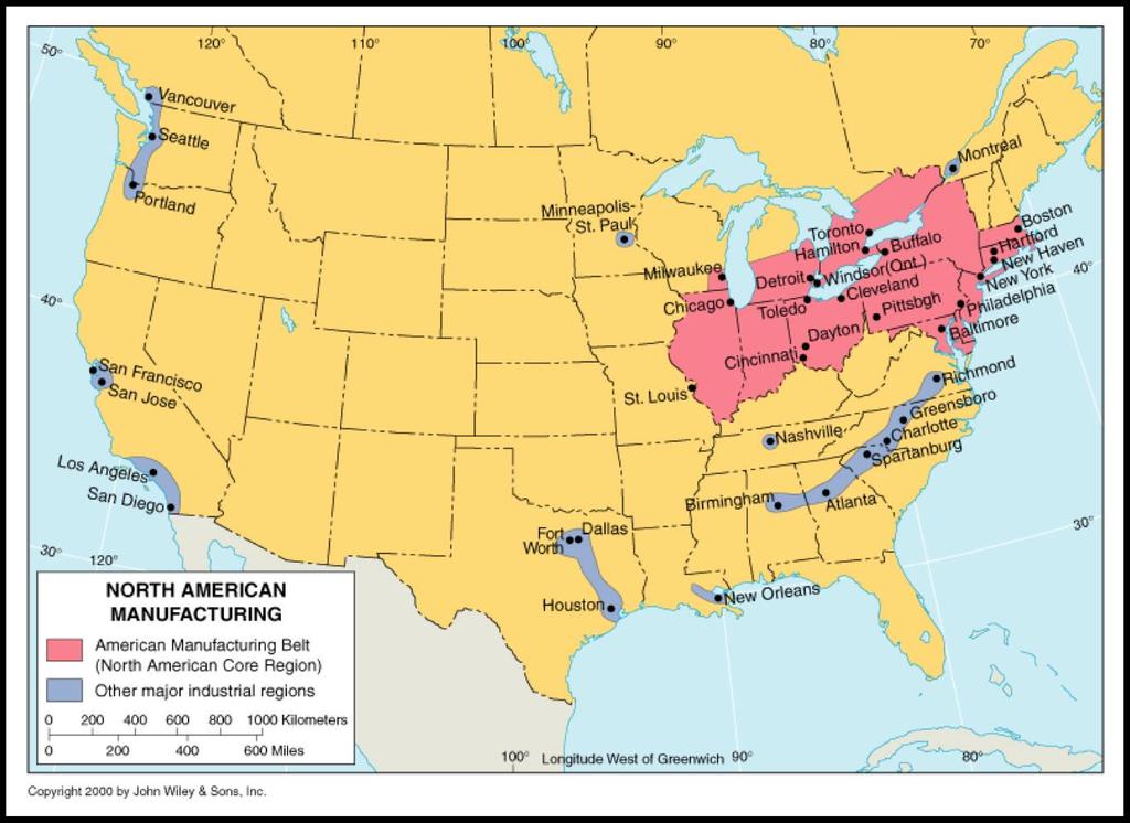
31 Situation Factors Transportation Issues Bulk-Gaining, Bulk Losing Site Factors The cost of Land, Labor, and Capital Climate Access to Amenities 31
32 Part Four: Contemporary Patterns in Industrialization 32
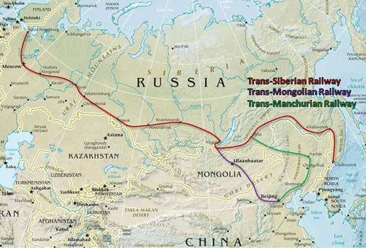
33 A) Globalization and Infrastructure 33


34 How Does Globalization Affect Industrialization? Every country s development is dependent on the rest of the world. With the increase of Space-Time Compression, it is possible to locate businesses in places not before considered. The Internet has made it possible for markets to exist where they have not before. In order to accommodate global industrialization a country must develop infrastructure. 34
35 What is infrastructure? 35

36 Infrastructure includes services that support economic activities. It provides for transportation, communication, education, and other external needs of a company. 36
37 B) Primary Industrial Regions 37
38 Western and Central Europe Eastern Asia Primary Regions Eastern North America Russia and the Ukraine 38
39 Western and Eastern Europe Expanded greatly after WWI. Was largest in Germany until WWII. Rebuilt with the help of America after WWII. North America The North American Manufacturing Belt extends from Boston and New York through Philadelphia and Baltimore. The Southeastern District: Birmingham, Alabama to Richmond, Va. Another: Oklahoma to Dallas, Houston, and New Orleans. Northern California: San-Fransisco Southern California: Los Angeles to San-Diego Pacific Northwest: Portland, Oregon through Seattle, Washington and Vancouver in Canada. 39
40 40
41 Russia and the Other Soviet Republics Much manufacturing up through the 1930s followed the Volga River. Other regions followed the Trans-Siberian Railroad. 41
42 42

 South")


43 Asia Japan The Kanto Plain Tokyo The Four Tigers (Export Oriented Industrialization) South Korea Taiwan Hong Kong Singapore China Northeast District in Manchuria Beijing, Shanghai, Hong Kong The Pacific Rim 43
44 C) Secondary Industrial Regions 44

45 Southeast Asia Secondary Industrial Regions Northern Africa Mexico Brazil 45
46 What is the maquiladora? 46
47 The Maquiladora is a manufacturing zone created in the 1960s in Mexico that mostly produces American products. 47
48 What is the NAFTA? 48
49 NAFTA is the North American Free Trade Agreement which eliminated barriers to free trade in North America. 49
Industrialization. Why Do Industries Have Different Distributions?
 Industrialization Why Do Industries Have Different Distributions? Industrial Revolution industry refers to the manufacturing of products Began in England in the late 1700s Diffused rest of Europe and North
Starting Assignment. What do you think is the greatest invention of the Industrial Revolution?
 Starting Assignment What do you think is the greatest invention of the Industrial Revolution? Hans Rosling makes the case for the washing machine. Rosling shows us the magic that pops up when economic
2/25/2019. Taking the northern and southern hemispheres together, on average the world s population lives 24 degrees from the equator.
 Where is the world s population? Roughly 88 percent of the world s population lives in the Northern Hemisphere, with about half north of 27 degrees north Taking the northern and southern hemispheres together,
THEORIES OF GLOBAL INTERCONNECTIONS. APWH Unit 6 Part to Present
 THEORIES OF GLOBAL INTERCONNECTIONS APWH Unit 6 Part 4 1900 to Present Myth of Isolation Truly isolated cultures have never existed 1000s of years, human groups have been in contact with each other (ex.
Guided Reading Activity
 Guided Reading Activity Lesson 1 Physical Features Essential Question: How does geography influence the way people live? A Vast Land Directions: Read the lesson and use your text to decide whether each
Map directions are broken down into 2 main types; Cardinal Directions and Intermediate Directions SW S
 ELEMENTS OF MAPS COMPASS ROSE AND DIRECTIONS When reading a map it s always important to know your directions. The Compass Rose is the tool to help you do that. Map directions are broken down into 2 main
Study Guide Unit 6 Economics and Development
 Name Period Study Guide Unit 6 Economics and Development When you are asked to sketch maps, please put a key so that you can remember what the colors mean! Chapter 9: Development How does the author introduce
23TGEO 220 COURSE OUTLINE. Prerequisites: None. Course Description:
 Lecture 23TGEO 220 23TWorld Regional Geography Revised: Fall 2015 COURSE OUTLINE Prerequisites: None Course Description: Studies physical and cultural characteristics of selected geographical regions of
Key Issue 1: Where Is Industry Distributed?
 Key Issue 1: Where Is Industry Distributed? Pages 395-397 ***Always keep your key term packet out whenever you take notes from Rubenstein. As the terms come up in the text, think through the significance
World Industrial Regions
 World Industrial Regions North America Industrialized areas in North America Changing distribution of U.S. manufacturing Europe Western Europe Eastern Europe East Asia Manufacturing Regions Fig. 11-3:
Chapter 12: Industry and Services
 Chapter 12: Industry and Services Concept Caching: Bicycle Use and Production in China Barbara Weightman Copyright Field Note: Branding the Backboard Walking through a relatively poor neighborhood in Skopje,
PLEASE DO NOT WRITE ON THIS TEST BOOKLET. MULTIPLE CHOICE. Choose the one alternative that best completes the statement or answers the question.
 Unit 6 Assessment PLEASE DO NOT WRITE ON THIS TEST BOOKLET MULTIPLE CHOICE. Choose the one alternative that best completes the statement or answers the question. 1) Compared to more developed countries,
Important Developments in International Coke Markets
 Important Developments in International Coke Markets Andrew Jones Resource-Net South Africa China Coke Market Congress Xuzhou, Jiangsu September 2018 Introduction to Presentation Resource-Net produces
Slide 1 Chapter 12: Industry and Services. Slide 2. Slide 3. Key Question. Where did the Industrial Revolution begin, and how did it diffuse?
 Slide 1 Chapter 12: Industry and Services Concept Caching: Bicycle Use and Production in China Barbara Weightman Copyright Slide 2 Field Note: Branding the Backboard Walking through a relatively poor neighborhood
TYPES OF GOVERNMENTS
 While the terms country, state, and nation are often used interchangeably, there is a difference. A State (note the capital "S") is a self-governing political entity. The term State can be used interchangeably
The Coordinate System
 5 The Coordinate System Key Words: latitude, degrees, longitude, prime meridian, absolute location You can locate any place on Earth by using a special set of numbers. These numbers are part of a set of
Explain the impact of location, climate, natural resources, and population distribution on Europe. a. Compare how the location, climate, and natural
 SS6G10 Explain the impact of location, climate, natural resources, and population distribution on Europe. a. Compare how the location, climate, and natural resources of Germany, the United Kingdom and
Answers to British Columbia Quizzes
 Answers to British Columbia Quizzes p. 1 Test Your Knowledge What do you remember from your review of the British Columbia section of the E-atlas? 1. What percentage of Canada's total area does British
AP * human Geography. Syllabus. Course Description. Course Description Materials. Course Goals
 AP * human Geography Syllabus Course Description AP Human Geography is a college-level, yearlong course designed to prepare students for the Advanced Placement (AP) Human Geography Exam. The goal of this
World Geography. BY MARK STANGE and REBECCA LARATTA
 BY MARK STANGE and REBECCA LARATTA COPYRIGHT 2002 Mark Twain Media, Inc. ISBN 1-58037-205-8 Printing No. CD-1551 Mark Twain Media, Inc., Publishers Distributed by Carson-Dellosa Publishing Company, Inc.
Global Data Catalog initiative Christophe Charpentier ArcGIS Content Product Manager
 Global Data Catalog initiative Christophe Charpentier ArcGIS Content Product Manager ccharpentier@esri.com We are in a global economy Global Economy Business and Operations are now global Strategic need
Unit 1 Test - Version A
 Unit 1 Test - Version A 1. Approximately, how many degrees of longitude equal one time zone change? a. 5 b. 10 c. 15 d. 20 e. 25 2. The city of Lewisville has a population of 1,000 people living in 100
World Geography Fall 2013 Semester Review Project
 Reporting Category RC 1: History, Government and Citizenship Standard WG.1 History. The student understands how geography and processes of spatial exchange (diffusion) influenced events in the past and
1 st Six Weeks # of Days. Unit # and Title Unit 1 Geography Overview
 1 st Six Weeks # of Days Unit # and Title Unit 1 Geography Overview Orange Grove ISD Instructional Planning Information and Process Standards The Process Standards Must Be Included in Each Unit # of Class
Population And Settlement Part I
 Population And Settlement Part I 0011 0010 1010 1101 0001 0100 1011 4 12 Think of the earth as a living organism that is being attacked by billions of bacteria whose numbers double every forty years. Either
Chapter 9: Looking Beyond Poverty: The Development Continuum
 Chapter 9: Looking Beyond Poverty: The Development Continuum Using measures such as Gross Domestic Product (GDP), Gross National Income (GNI), and more recently the Human Development Index (HDI), various
Cardinal and Intermediate Directions:
 Name Period Parent Signature Due Date: (TBA) Geography/Map Skills Study Guide Continents and Oceans of the World: Label the continents (7) and oceans (4) on the lines below the map. 1 11 3 5 4 8 2 9 10
Urban Geography Unit Test (Version B)
") Urban Geography Unit Test (Version B) 1. What function do the majority of the world s ten most populated cities serve? a. a fortress city to resist foreign invasion b. a port city for transporting people
Urban Geography Unit Test (Version B) 1. What function do the majority of the world s ten most populated cities serve? a. a fortress city to resist foreign invasion b. a port city for transporting people
Aerospace part number guide
 TRELLEBORG SEALING SOLUTIONS Aerospace part number guide YOUR PARTNER FOR SEALING TECHNOLOGY Your Partner for Sealing Technology Trelleborg Sealing Solutions is a major international sealing force, uniquely
2 Georgia: Its Heritage and Its Promise
 TERMS region, erosion, fault, elevation, Fall Line, aquifer, marsh, climate, weather, precipitation, drought, tornado, hurricane, wetland, estuary, barrier island, swamp PLACES Appalachian Mountains, Appalachian
Appendix B: Detailed tables showing overall figures by country and measure
 44 country and measure % who report that they are very happy Source: World Values Survey, 2010-2014 except United States, Pew Research Center 2012 Gender and Generations survey and Argentina 32% 32% 36%
Cities, Countries, and Population
 Cities, Countries, and Population After the world industrialized, better food, improved sanitation, and new medicines caused the world population to soar. To understand how heavily populated an area is,
Cultural Diffusion. AP HG SRMHS Mr. Hensley
 Cultural Diffusion AP HG SRMHS Mr. Hensley Space-time compression: The reduction in time it takes for something to reach another place Because of technology, connections have reduced distance (not literally
Social Studies Framework K-12 ( ) 1
 1") RIVERVIEW SCHOOL DISTRICT NO. 407 STRAND CIVICS (GOVERNMENT) ECONOMICS HISTORY GEOGRAPHY Grade K Me & My Community Working together Purpose of rules Being a community contributor Compare/contrast needs
RIVERVIEW SCHOOL DISTRICT NO. 407 STRAND CIVICS (GOVERNMENT) ECONOMICS HISTORY GEOGRAPHY Grade K Me & My Community Working together Purpose of rules Being a community contributor Compare/contrast needs
Location Patterns of Manufacturing Industries in Tunisia
 Location Patterns of Manufacturing Industries in Tunisia Wided Mattoussi WIDER development conference: Think development Think WIDER Parallel session Made in Africa Motivation Firms enjoy positive externalities
Cotton Economics Research Institute CERI Outlook Report
 2006 Global Cotton Outlook Cotton Economics Research Institute CERI Outlook Report 06-02 www.ceri.ttu.edu/policy CERI (Policy Modeling Group) Samarendu Mohanty, Associate Professor Suwen Pan, Research
Reshaping Economic Geography
 Reshaping Economic Geography Three Special Places Tokyo the biggest city in the world 35 million out of 120 million Japanese, packed into 4 percent of Japan s land area USA the most mobile country More
Selected Papers from the 2 nd World Forum on China Studies (Abstracts) Panel 12 Shanghai's Development in Multi-scaled Perspectives
 Panel 12 Shanghai's Development in Multi-scaled Perspectives") Shanghai Academy of Social Sciences World Forum on China Studies Selected Papers from the 2 nd World Forum on China Studies (Abstracts) Panel 12 Shanghai's Development in Multi-scaled Perspectives Contents:
Shanghai Academy of Social Sciences World Forum on China Studies Selected Papers from the 2 nd World Forum on China Studies (Abstracts) Panel 12 Shanghai's Development in Multi-scaled Perspectives Contents:
Unit 1 Welcome to the World
 Unit Welcome to the World There are five fields of learning in social studies. We learn about the world and its people by studying geography, history, economics, government, and culture. A Mongolian yurt,
Five Themes of Geography Project Ms. Kiesel, Per 5. The United States of America
 Five Themes of Geography Project Ms. Kiesel, Per 5 The United States of America Location Absolute Location : The USA is located in the continent of North America in the northern and western hemispheres.
What is the largest country in the world? Russia
 What is the largest country in the world? #1 Russia CSCOPE 2007 2 Russia Dimensions #2-3 Spans 11 Time Zones From East to West: Gulf of Finland to Alaska From North to South: Above the Arctic Circle to
What on Earth is Geography? Using the Five Themes of Geography to Study the Continent of Asia.
 What on Earth is Geography? Using the Five Themes of Geography to Study the Continent of Asia. Name Date Essential questions: 1. How can we study the geography of our Earth? a. What are the five themes
A Shift to the Sunbelt
 Adam Giladi 4/1/13 A Shift to the Sunbelt The changing global economy has lead to an increased interconnection between nations and the mass movement of individuals from one area to another. This movement
The study of Geography and the use of geographic tools help us view the world in new ways.
 S How does Geography help us understand our world? What factors shape the Earth s different environments? 7.1.9 7.2.9 BIG IDEAS COMPETENCIES Text pages or The study of Geography and the use of geographic
September 14, 2013 Objective: How does geography impact history? What important features exist that have shaped societies?
 Lowenhaupt 1 September 14, 2013 Objective: How does geography impact history? What important features exist that have shaped societies? Warm-Up: In your binder, answer the following question: Imagine you
Developing a global, peoplebased definition of cities and settlements
 Developing a global, peoplebased definition of cities and settlements By Lewis Dijkstra, Lewis.Dijkstra@ec.europa.eu Head of the Economic Analysis Sector DG for Regional and Urban Policy, Regional & Urban
AP Human Geography Free-response Questions
 AP Human Geography Free-response Questions 2000-2010 2000-preliminary test 1. A student concludes from maps of world languages and religions that Western Europe has greater cultural diversity than the
Climate Outlook for March August 2018
 The APEC CLIMATE CENTER Climate Outlook for March August 2018 BUSAN, 26 February 2018 The synthesis of the latest model forecasts for March to August 2018 (MAMJJA) from the APEC Climate Center (APCC),
Measuring Export Competitiveness
 Dynamic Measures of Competitiveness: Are the Geese Still Flying in Formation? Andrew K. Rose U.C. Berkeley and visiting scholar, FRB San Francisco Haas School of Business, Berkeley CA 94720-900 Tel: (50)
9/19/2018. Dr. Hoch. RGPL 103 Global Cities: Planning and Development.
 Dr. Hoch RGPL 103 Global Cities: Planning and Development Dr. Hoch Email: rhoch@iup.edu 1 2 Earth s Orbit Around Sun Aphelion July 6 (12:00) Perihelion Jan 3 (00:00) EARTH 152.5 Million Km 147.5 Mil. Km
AP Human Geography AP EXAM Free Response Questions and Possible Future Questions
 AP Human Geography AP EXAM Free Response Questions and Possible Future Questions FRQ Exam Questions: Population & Migration 2003- European Migration and Demographic Transition Model 2004- Population Pyramids
Density. These are the four ways to identify a location
 Density The number of objects per unit of land area Unit 1 100 Toponym, Site, Situation, Absolute Location These are the four ways to identify a location Unit 1 200 1 Relocation and Expansion Diffusion
Oil and petrochemical industry Regional Differences
 Oil and petrochemical industry Regional Differences CSB Washington 28 Jan 2008 Page 1 OPC from a reinsurers view Content Project findings of selective U/W (ernst) Regional differences of operational hazards
Amarillo ISD Grade 6 Standards
 Amarillo Independent School District follows the Texas Essential Knowledge and Skills (TEKS). All of AISD curriculum and documents and resources are aligned to the TEKS. The State of Texas State Board
4 th Grade Virginia Studies SOL Review Packet Geography of Virginia. 1. The Algonquian language group of Indians lived in what region of Virginia?
 4 th Grade Virginia Studies SOL Review Packet Geography of Virginia 1. The Algonquian language group of Indians lived in what region of Virginia? A. Allegheny B. Piedmont C. Ridge and Valley D. Tidewater
Growth of Urban Areas. Urban Hierarchies
 Growth of Urban Areas Urban Hierarchies Directions: In your notebook, complete the following on the right: Create a chart to explain and analyze the gravity model, central place theory, bid-rent theory,
Why has globalisation brought such large increases in exports to some countries and not to others?
 by Stephen Redding and Anthony Venables Why has globalisation brought such large increases in exports to some countries and not to others? Stephen Redding and Anthony Venables look at the way internal
Simple Solutions Social Studies Level 2. Level 2. Social Studies. Help Pages
 Level 2 Social Studies 147 148 adobe houses with bricks made of clay and straw ancestor a family member who lived before us appoint choose; leaders can appoint others barter trading one thing for another
22 cities with at least 10 million people See map for cities with red dots
 22 cities with at least 10 million people See map for cities with red dots Seven of these are in LDC s, more in future Fastest growing, high natural increase rates, loss of farming jobs and resulting migration
CHAPTER 1. Geo Challenges 1A to 1D. & World Map Activity
 CHAPTER 1 Geo Challenges 1A to 1D & World Map Activity SELECT YOUR CHALLENGE World Map Activity Challenge 1A Challenge 1B Challenge 1C Challenge 1D Challenge 1A WS PG. 2 STEP #1 Label the largest continent
Map Skills Test. 1. What do we call a person who makes maps? a. mapographer b. cartographer c. geologist d. archaeologist
 Map Skills Test 1. What do we call a person who makes maps? a. mapographer b. cartographer c. geologist d. archaeologist 2. What is the name of the 0 latitude line? a. Equator b. Arctic Circle c. First
ELEMENTS OF BASIC WORLD GEOGRAPHY TABLE OF CONTENTS UNIT 1 THE BASICS OF GEOGRAPHY AND NORTH AMERICA
 TABLE OF CONTENTS UNIT 1 THE BASICS OF GEOGRAPHY AND NORTH AMERICA IMPORTANT WORDS TO KNOW... 1 CHAPTER 1 THE BASICS OF GEOGRAPHY GEOGRAPHY... 2 TOOLS OF GEOGRAPHY... 3 EARTH...4 SEASONS, CLIMATE, AND
Phase 1 Cards. Phase 1. Phase 1. How many picnic areas does the park have? Write the answer near the legend.
 S T U D E N T H A N D O U T F Cards Write the map s title in the northwest corner above the map. How many picnic areas does the park have? Write the answer near the legend. 1 2 Draw a compass rose near
Latitude & Longitude. Worksheets & activities to teach latitude & longitude. Includes notes, activities, review & all answer keys. 11 pages!
 Latitude & Longitude Worksheets & activities to teach latitude & longitude. Includes notes, activities, review & all answer keys. 11 pages! Lines of Latitude & Longitude Name: Lines of latitude and longitude
A Correlation of. Eastern Hemisphere. Ohio s Learning Standards Social Studies: K-12 Grade 6
 A Correlation of Eastern Hemisphere To Grade 6 to,, Grade 6 Introduction This document demonstrates how, Eastern Hemisphere, Ohio Edition, meets : K-12 Social Studies for Grade 6. Correlation page references
LEARNING OUTCOMES SST (G1-G12)
") LEARNING OUTCOMES SST (G1-G12) Grade 1 Learning Outcomes Students will be expected to: - demonstrate an understanding of the importance of interactions between people - demonstrate an understanding of
LEARNING OUTCOMES SST (G1-G12) Grade 1 Learning Outcomes Students will be expected to: - demonstrate an understanding of the importance of interactions between people - demonstrate an understanding of
Chapter 1. Social Studies History and Geography
 Chapter 1 Social Studies History and Geography Unit 01 Geography Skills 1 Reading Maps Key Words border landform rely on display focus on route locater 1 There are many different kinds of maps. A political
1. Match the words in the first column to the meaning in the second column. [5]
![1. Match the words in the first column to the meaning in the second column. [5]](/thumbs/96/126839765.jpg "1. Match the words in the first column to the meaning in the second column. [5]") Exercise 1: [40 POINTS] 1. Match the words in the first column to the meaning in the second column. [5] Equator Around earth between the Equator and the Poles. Greenwich meridian Half of earth. Longitude
Exercise 1: [40 POINTS] 1. Match the words in the first column to the meaning in the second column. [5] Equator Around earth between the Equator and the Poles. Greenwich meridian Half of earth. Longitude
TRANS-NZOIA COUNTY JOINT EVALUATION EXAMINATION-2014 Kenya Certificate of Secondary Education
 312/2 GEOGRAPHY PAPER 2 JULY/AUGUST 2014 TIME: 2¾ HOURS TRANS-NZOIA COUNTY JOINT EVALUATION EXAMINATION-2014 Kenya Certificate of Secondary Education GEOGRAPHY PAPER 2 TIME: 2¾ HOURS INSTRUCTIONS TO CANDIDATES:
Post Show Report The 33 rd China Wedding Expo
 Post Show Report The 33 rd China Wedding Expo 01 Show profile 02 Exhibits Scope 03 Exhibitor Analysis 04 Visitor Analysis 05 Media Publicity 06 Concurrent Activities 07 VIP List 08 Moments Show Profile
IR-4: Classroom Grid Region 4 Education Service Center Geography by Design, Volume 1
 IR-4: Classroom Grid 2013 Region 4 Education Service Center Geography by Design, Volume 1 IR-5: Latitude/Longitude Coordinates Location Latitude Longitude 35 N 139 E 11 N 104 E 1 N 103 E 18 N 72 E 59 N
A Correlation of. Ohio s Learning Standards in Social Studies. Grade 5
 A Correlation of 2019 To in Social Studies Grade 5 Introduction The all new myworld Interactive Social Studies encourages students to explore their world, expand their thinking, and engage their college,
Chapter 12. Key Issue Three: Why do business services locate in large settlements?
 Chapter 12 Key Issue Three: Why do business services locate in large settlements? Business Services and Settlements World cities Ancient world cities Medieval world cities Modern world cities Hierarchy
Complete the following: a. Lines of latitude are parallel to the equator. Name:
 Name: Date: Social Studies Introduction: Basic Geography Period: Latitude Latitude is defined as a measurement of distance in degrees north and south of the equator. The word latitude is derived from the
Melting Ice Caps: Implications for Asia-North America Linkages and the Panama Canal
 Melting Ice Caps: Implications for Asia-North America Linkages and the Panama Canal Joseph Francois, Amanda Leister and Hugo Rojas-Romagosa 2015 MASS, St. John s Francois, Leister & Rojas-Romagosa (2015)
Student Handout. Write the map s title in the northwest corner of the map. How many picnic areas does the park have? Write the answer near the legend.
 Student Handout 1F Cards Write the map s title in the northwest corner of the map. How many picnic areas does the park have? Write the answer near the legend. 1 2 Draw a compass rose near the west edge
Geography. Programmes of study for Key Stages 1-3
 Geography Programmes of study for Key Stages 1-3 February 2013 Contents Purpose of study 3 Aims 3 Attainment targets 3 Subject content 4 Key Stage 1 4 Key Stage 2 5 Key Stage 3 6 2 Purpose of study A high-quality
 Name Period Parent Signature Geography/Map Skills Study Guide *For extra practice with these skills, check out Mr. Kath s website: http://rkath.weebly.com/activities--links.html Continents and Oceans of
PAGE(S) WHERE TAUGHT (If submission is not a book, cite appropriate location(s))
 WHERE TAUGHT (If submission is not a book, cite appropriate location(s))") The Kentucky Core Content for Assessment (version 3.0) forsocial Studies (Grades 6 8) Government and Civics The study of government and civics allows students to understand the nature of government and
The Kentucky Core Content for Assessment (version 3.0) forsocial Studies (Grades 6 8) Government and Civics The study of government and civics allows students to understand the nature of government and
Range of Opportunities
 Geograhy Curriculum Cropwell Bishop Primary School Range of Opportunities Year 1 Year 2 Year 3 Year 4 Year 5 Year 6 All Key Stage 1 Key Stage 2 Investigate the countries and capitals of the United Kingdom.
Forecast Million Lbs. % Change 1. Carryin August 1, ,677, ,001, % 45.0
 Almond Industry Position Report NOVEMBER 2017 2017-2018 Crop Year Salable Forecast Million Lbs. 2017-2018 08/01-11/30 Kernel Wt. 2016-2017 08/01-11/30 Kernel Wt. % Change 1. Carryin August 1, 2017 398.7
7.1Solvingsys2015.notebook. November 05, Warm up. Partial fraction decompostion
 Warm up Partial fraction decompostion 1 Please add due dates to the calendar Nov Dec 2 7.1 Solving Systems of Equations by Substitution and Graphing Vocabulary System: Problems that involve two or more
Chapter 9 - Key Issues 1 & 2: Why does development vary among countries? Why does development vary by gender? p
 Chapter 9 - Key Issues 1 & 2: Why does development vary among countries? Why does development vary by gender? p. 301-313 Enduring Understanding B. Measures of development are used to understand patterns
A Study on Trade of Complementarity among Xinjiang and Its Neighboring Countries
 A Study on Trade of Complementarity among injiang and Its Neighboring Countries inshu Gong School of Economics & Trade, Shihezi University Shihezi 832003, China Tel: 86-993-205-8996 E-mail: gxsjm10@sohu.com
Physical Geography. Ariel view of the Amazon Rainforest. A Look at the Seven Continents
 Physical Geography In this unit you will learn about general physical geography. The study of the Earth s surface features provides the setting for the human-environmental interactions and for the human
Options and Implications of Free Trade Arrangements in Asia. Jun Ma, Deutsche Bank AG Zhi Wang, ERS, USDA June 2002
 Options and Implications of Free Trade Arrangements in Asia Jun Ma, Deutsche Bank AG Zhi Wang, ERS, USDA June 2002 Content Our CGE Model China s WTO entry implies smaller world market shares for some ASEAN
2nd in State HSC GEOGRAPHY- Urban Places
 HSC Geography Year 2014 Mark 97.00 Pages 19 Published Jan 7, 2017 2nd in State HSC GEOGRAPHY- Urban Places By Leah (97.7 ATAR) Powered by TCPDF (www.tcpdf.org) Your notes author, Leah. Leah achieved an
Prentice Hall World Cultures: A Global Mosaic 2004 Correlated to: Wisconsin Model Academic Standards for Social Studies (By the end of Grade 12)
") Wisconsin Model Academic Standards for Social Studies (By the end of Grade 12) A. Geography: People, Places, and Environments A.12.1 Use various types of atlases and appropriate vocabulary to describe
Wisconsin Model Academic Standards for Social Studies (By the end of Grade 12) A. Geography: People, Places, and Environments A.12.1 Use various types of atlases and appropriate vocabulary to describe
Peoples, Places and Cultures in Africa, Asia and the Southwest Pacific
 GRADE 7 Peoples, Places and Cultures in Africa, Asia and the Southwest Pacific Course 0470-07 Students in seventh grade explore the history, geography, government, economic systems, current issues, and
Sixth Grade Social Studies. QPA Schedule
 2017 2018 Sixth Grade Social Studies Unit 1: Concepts Used in Global Studies 5 Weeks Unit 2: History & Geography of Europe 5 Weeks Unit 3: Europe Today 6 Weeks Unit 4: History & Geography of Latin America
Central Valley School District Social Studies Curriculum Map Grade 7. August - September
 August - September Geographical/Historical Skills Identify and analyze timelines. Construct and use cause and effect charts. Differentiate between fact and opinion. Use of word webs, flip charts, outlines
Forecast Million Lbs. % Change 1. Carryin August 1, ,677, ,001, % 45.0
 Almond Industry Position Report DECEMBER 2017 2017-2018 Crop Year Salable Forecast Million Lbs. 2017-2018 08/01-12/31 Kernel Wt. 2016-2017 08/01-12/31 Kernel Wt. % Change 1. Carryin August 1, 2017 398.7
Additional VEX Worlds 2019 Spot Allocations
 Overview VEX Worlds 2019 Spot s Qualifying spots for the VEX Robotics World Championship are calculated twice per year. On the following table, the number in the column is based on the number of teams
6 th grade SS. Unit 8. Suggested Dates. Russia and the Eurasian Republics. Geographic factors influence a countries economic development.
 Title Russia and the Eurasian Republics 6 th grade SS Suggested Dates 2 weeks Unit 8 Big Idea/Enduring Understanding Geographic factors influence a countries economic development. The Factors of Production
Proposed AKS for 6 th Grade Social Studies
 Proposed AKS for 6 th Grade Social Studies A. Map and Globe Skills 1. use cardinal directions 2. use intermediate directions 3. use a letter/number grid system to determine location 4. compare and contrast
Cambridge International Examinations Cambridge International General Certificate of Secondary Education
 Cambridge International Examinations Cambridge International General Certificate of Secondary Education *6838706465* GEOGRAPHY 0460/22 Paper 2 May/June 2016 Candidates answer on the Question Paper. Additional
2017 Source of Foreign Income Earned By Fund
 2017 Source of Foreign Income Earned By Fund Putnam Emerging Markets Equity Fund EIN: 26-2670607 FYE: 08/31/2017 Statement Pursuant to 1.853-4: The fund is hereby electing to apply code section 853 for
CropCast Daily Agro-Highlights Don Keeney Friday, April 22, 2016
 VHI Image Date: Apr 14, 2016 USA Wheat Corn Soybeans Vegetative Health Index Map and Crop Condition Tendency EUROPE Wheat Rapeseed FSU Wheat CHINA Wheat Rapeseed ARGENTINA Corn Soybeans BRAZIL Corn Soybeans
Oklahoma Academic Standards Science Grade: 6 - Adopted: 2014
 Main Criteria: Oklahoma Academic Standards Secondary Criteria: Subjects: Science, Social Studies Grade: 6 Correlation Options: Show Correlated OK.6-LS. Oklahoma Academic Standards Science Grade: 6 - Adopted:
Map List. 560 World World Physical World Physical-Pacific & Atlantic Region World Landforms World Ocean Floor 10
 Map List CategoryName Map# MapName Thumb nail Page # 560 World 2 561 World Physical 4 562 World Physical-Pacific & Atlantic Region 6 563 World Landforms 8 564 World Ocean Floor 10 565 North Polar Region