UNDERSEA FEATURE NAME PROPOSAL PROPOSITION DE NOM POUR UNE FORME DU RELIEF SOUS-MARIN (See NOTE overleaf / VoirNOTE au verso)
|
|
|
- Terence Stafford
- 6 years ago
- Views:
Transcription
1 INTERNATIONAL HYDROGRAPHIC INTERGOVERNMENTAL OCEANOGRAPHIC ORGANIZATION COMMISION (of UNESCO) ORGANIZATION HYDROGRAPHIQUE INTERNATIONALECOMISSION OCEANOGRAPHIQUE INTERGOUVERNEMENTALE UNDERSEA FEATURE NAME PROPOSAL PROPOSITION DE NOM POUR UNE FORME DU RELIEF SOUS-MARIN (See NOTE overleaf / VoirNOTE au verso) Notes: a) Translation in French is provided for convenience.however, the form should be filled in English. La traductionenfrançaisestfournie à titre d aide. Toutefois, le formulairedoitêtreremplienanglais. b) The boxes will expand as you fill the form. Les cadres s élargiront au fur et à mesure que vousremplirez le formulaire. Name Proposed: Nom propose: Mustapha Hill Ocean or sea: Ocean oumer: South China Sea Geometrythat best defines the feature (Yes/No): Geometriedefinissant le mieux la forme (Oui/Non): Point Point Line Ligne Polygon Polygone Multiple points Points multiples Yes Yes *Geometry should be clearly distinguished when providing the coordinates below. La geometriedoitetreclairmentidentifeeenfournissant les coordonnees ci-dessous. Multiple lines* Lignes Multiples* Multiple polygons* Polygones Multiples* Combination of Geometries* Combinaison des geometries* Coordinates: Coordonnees: Lat. (e.g n) N (Summit) N N N N N N N N N N N N N N N N N N N N N N N Long. (e.g W) E (Summit) E E E E E E E E E E E E E E E E E E E E E E E Features Description: Descriptionn de la forme Du relief : Maximum Depth: Profondeur max: Minimum Depth: Profondeur min: Total Relief: Relief total: m m m Steepness: Declivite: Shape: Forme: Dimension / Size: Dimension / Taille: 45 Oval 11.3 km² Associated Features: Formes aux cartes: Chart / Map References: References aux cartes: Shown Named on Map / Chart: Est representee, avec son nom, sur la carte: Shown Unnamed on Map / Chart: Est representee, sans nom, sur la carte: Within Area of Map / Chart: Couverte par la carte: MAL 6, MAL 781 and MAL 885 MAL 6, MAL 781 and MAL 885
2 Reason for Choice of Name (if a person, state how associated with the feature to be named): Raison du choix du nom (s`ils`agaitd`unepersoonne, preciser de quellemaniereelleestassocieea`laforme du relief a denommer): Tun Datu Haji Mustapha bin Datu Harun was the first governor of the Malaysian state of Sabah, the third Chief Minister of the state from 1967 to 1975, and was the president for the political party United Sabah National Organisation (USNO). He is considered by some to be one of the founding leaders of Sabah and was an important party in the negotiations leading to the formation of Malaysia on 16 September Therefore, he is known to some as the "father of Sabah's independence" and also the "father of Sabah's development". Seems the undersea feature was mapped and located near to Sabah water, is thus proposed to be named as Mustapha, after this first Sabah state governor. Discovery Facts: Renseignementsconcernant la decouverte: Discovery Date: Date de la decouverte: Discoverer (Individual, Ship): Decouvreur (personneounavire): Sep 2013 MV Hartamas Supporting Survey Data, including Track Controls: Donnees de sondagea`l`appui, incluant des profils de controle: Date of Survey: 2 Date du leve`: nd Jul till 3 rd Dec 2013 Survey Ship: MV Hartamas Navire: Sounding Equipment: Konsberg EM 122 Moyens de sondage: Type of Navigation: Wide Area DGPS Veripos LD4 Mode de navigation: Estimated Horizontal Accuracy (nm): Precision de la position estimee, enmilles 2 m (0.001 nm) Marins: Survey Track Spacing: 100% overlapping multibeam Espacement entre les profils de sonde: Supporting material can be submitted as Annex in analog or digital form: Des documents peuventetre joints a`l`appui de la proposition sous formeanalogiqueounumerique. Proposer(s): Presente`par: Name(s): Rear Admiral Zaaim bin Hasan Nom(s): Date: 15 Jul zaaim@hydro.gov.my Organization and Address: National Hydrographic Centre, Organisation et adresse: Bandar Armada Putra Pulau Indah Port Klang Malaysia Concurrer (name, , organization and address): Appuye`par (nom, , organization et adresse): Remarks: Remarques:
3 Location of Mustapha Hill:


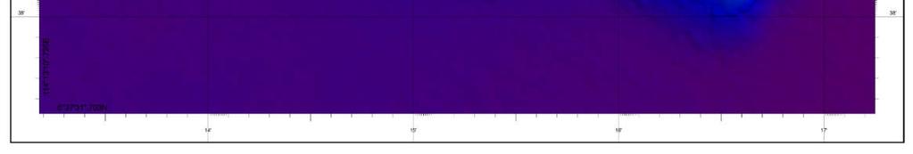
4 2D View

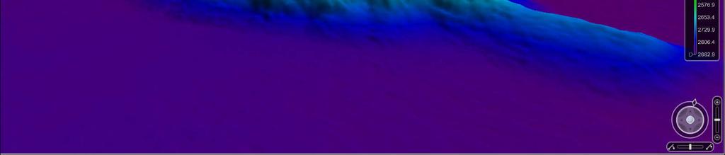
5 3D View


6 Profile of the Mustapha Hill A C D B
7 A B
8 C D
UNDERSEA FEATURE NAME PROPOSAL (See IHO-IOC Publication B-6 and NOTE overleaf)
") INTERNATIONAL HYDROGRAPHIC ORGANIZATION INTERGOVERNMENTAL OCEANOGRAPHIC COMMISSION (of UNESCO) Note: The boxes will expand as you fill the form. UNDERSEA FEATURE NAME PROPOSAL (See IHO-IOC Publication
INTERNATIONAL HYDROGRAPHIC ORGANIZATION INTERGOVERNMENTAL OCEANOGRAPHIC COMMISSION (of UNESCO) Note: The boxes will expand as you fill the form. UNDERSEA FEATURE NAME PROPOSAL (See IHO-IOC Publication
UNDERSEA FEATURE NAME PROPOSAL (See IHO-IOC Publication B-6 and NOTE overleaf) S (centre) S S S
 S (centre) S S S") INTERNATIONAL HYDROGRAPHIC ORGANIZATION INTERGOVERNMENTAL OCEANOGRAPHIC COMMISSION (of UNESCO) Note: The boxes will expand as you fill the form. UNDERSEA FEATURE NAME PROPOSAL (See IHO-IOC Publication
INTERNATIONAL HYDROGRAPHIC ORGANIZATION INTERGOVERNMENTAL OCEANOGRAPHIC COMMISSION (of UNESCO) Note: The boxes will expand as you fill the form. UNDERSEA FEATURE NAME PROPOSAL (See IHO-IOC Publication
Valdivia Fracture Zone, Mocha Fracture Zone
 lafkeninternational HYDROGRAPHIC ORGANIZATION INTERGOVERNMENTAL OCEANOGRAPHIC COMMISSION (of UNESCO) Note: The boxes will expand as you fill the form. UNDERSEA FEATURE NAME PROPOSAL (Sea NOTE overleaf)
UNDERSEA FEATURE NAME PROPOSAL (See NOTE overleaf)
") INTERNATIONAL HYDROGRAPHIC ORGANIZATION INTERGOVERNMENTAL OCEANOGRAPHIC COMMISSION (of UNESCO) Note: The boxes will expand as you fill the form. UNDERSEA FEATURE NAME PROPOSAL (See NOTE overleaf) Name
INTERNATIONAL HYDROGRAPHIC ORGANIZATION INTERGOVERNMENTAL OCEANOGRAPHIC COMMISSION (of UNESCO) Note: The boxes will expand as you fill the form. UNDERSEA FEATURE NAME PROPOSAL (See NOTE overleaf) Name
UNDERSEA FEATURE NAME PROPOSAL (Sea NOTE overleaf)
") INTERNATIONAL HYDROGRAPHIC ORGANIZATION INTERGOVERNMENTAL OCEANOGRAPHIC COMMISSION (of UNESCO) Note: The boxes will expand as you fill the form. UNDERSEA FEATURE NAME PROPOSAL (Sea NOTE overleaf) Name
INTERNATIONAL HYDROGRAPHIC ORGANIZATION INTERGOVERNMENTAL OCEANOGRAPHIC COMMISSION (of UNESCO) Note: The boxes will expand as you fill the form. UNDERSEA FEATURE NAME PROPOSAL (Sea NOTE overleaf) Name
Crater, fault, volcanic cone, lava flow
 2-1 INTERNATIONAL HYDROGRAPHIC ORGANIZATION INTERGOVERNMENTAL OCEANOGRAPHIC COMMISSION (of UNESCO) Note: The boxes will expand as you fill the form. UNDERSEA FEATURE NAME PROPOSAL (Sea NOTE overleaf) Name
UNDERSEA FEATURE NAME PROPOSAL (Sea NOTE overleaf) Matoba Seamount
 Matoba Seamount") 2-1 INTERNATIONAL HYDROGRAPHIC ORGANIZATION INTERGOVERNMENTAL OCEANOGRAPHIC COMMISSION (of UNESCO) Note: The boxes will expand as you fill the form. UNDERSEA FEATURE NAME PROPOSAL (Sea NOTE overleaf) Name
2-1 INTERNATIONAL HYDROGRAPHIC ORGANIZATION INTERGOVERNMENTAL OCEANOGRAPHIC COMMISSION (of UNESCO) Note: The boxes will expand as you fill the form. UNDERSEA FEATURE NAME PROPOSAL (Sea NOTE overleaf) Name
Asano Seamount, MIT Guyot
 2-1 INTERNATIONAL HYDROGRAPHIC ORGANIZATION INTERGOVERNMENTAL OCEANOGRAPHIC COMMISSION (of UNESCO) Note: The boxes will expand as you fill the form. UNDERSEA FEATURE NAME PROPOSAL (Sea NOTE overleaf) Name
UNDERSEA FEATURE NAME PROPOSAL (Sea NOTE overleaf)
") INTERNATIONAL HYDROGRAPHIC ORGANIZATION INTERGOVERNMENTAL OCEANOGRAPHIC COMMISSION (of UNESCO) Note: The boxes will expand as you fill the form. UNDERSEA FEATURE NAME PROPOSAL (Sea NOTE overleaf) Name
INTERNATIONAL HYDROGRAPHIC ORGANIZATION INTERGOVERNMENTAL OCEANOGRAPHIC COMMISSION (of UNESCO) Note: The boxes will expand as you fill the form. UNDERSEA FEATURE NAME PROPOSAL (Sea NOTE overleaf) Name
UNDERSEA FEATURE NAME PROPOSAL (Sea NOTE overleaf)
") INTERNATIONAL HYDROGRAPHIC ORGANIZATION INTERGOVERNMENTAL OCEANOGRAPHIC COMMISSION (of UNESCO) UNDERSEA FEATURE NAME PROPOSAL (Sea NOTE overleaf) Note: The boxes will expand as you fill the form. Name
INTERNATIONAL HYDROGRAPHIC ORGANIZATION INTERGOVERNMENTAL OCEANOGRAPHIC COMMISSION (of UNESCO) UNDERSEA FEATURE NAME PROPOSAL (Sea NOTE overleaf) Note: The boxes will expand as you fill the form. Name
Coordinates : A - of midpoint or summit : Lat., Long. } to. Description (kind of feature) : seachannel
 : seachannel") INTERNATIONAL HYDROGRAPHIC ORGANIZATION INTERGOVERNMENTAL OCEANOGRAPHIC COMMISSION (of UNESCO) IHO/IOC Form No. 1 UNDERSEA FEATURE NAME PROPOSAL (See NOTE overleaf) Ocean or Sea Japan Sea Name proposed
INTERNATIONAL HYDROGRAPHIC ORGANIZATION INTERGOVERNMENTAL OCEANOGRAPHIC COMMISSION (of UNESCO) IHO/IOC Form No. 1 UNDERSEA FEATURE NAME PROPOSAL (See NOTE overleaf) Ocean or Sea Japan Sea Name proposed
UNDERSEA FEATURE NAME PROPOSAL. Name Proposed: Kiminu Seamount. to Long.
 INTERNATIONAL HYDROGRAPHIC ORGANIZATION INTERNATIONAL OCEANOGRAPHIC COMMISSION (of UNESCO) UNDERSEA FEATURE NAME PROPOSAL Ocean or Sea: East Sea Name Proposed: Coordinates: A of midpoint or summit: Lat.
UNDERSEA FEATURE NAME PROPOSAL (See NOTE overleaf) Ocean or Sea Atlantic Ocean Name proposed Jean Charcot Seamounts. kilometres in direction from
 Ocean or Sea Atlantic Ocean Name proposed Jean Charcot Seamounts. kilometres in direction from") INTERNATIONAL HYDROGRAPHIC ORGANIZATION INTERGOVERNMENTAL OCEANOGRAPHIC COMMISSION (of UNESCO) IHO/IOC Form No. 1 UNDERSEA FEATURE NAME PROPOSAL (See NOTE overleaf) Ocean or Sea Atlantic Ocean Name proposed
INTERNATIONAL HYDROGRAPHIC ORGANIZATION INTERGOVERNMENTAL OCEANOGRAPHIC COMMISSION (of UNESCO) IHO/IOC Form No. 1 UNDERSEA FEATURE NAME PROPOSAL (See NOTE overleaf) Ocean or Sea Atlantic Ocean Name proposed
Coordinates : A - of midpoint or summit : Lat S, Long W
 INTERNATIONAL HYDROGRAPHIC ORGANIZATION SCUFN19-6.1K INTERGOVERNMENTAL OCEANOGRAPHIC COMMISSION (of UNESCO) IHO/IOC Form No. 1 UNDERSEA FEATURE NAME PROPOSAL (See NOTE overleaf) Ocean or Sea: Scotia Sea
Multibeam Mapping of Feature Rich Seafloor in the U.S. Pacific Remote Islands Marine National Monument and on Mendocino Ridge off the California Coast
 University of New Hampshire University of New Hampshire Scholars' Repository Center for Coastal and Ocean Mapping Center for Coastal and Ocean Mapping 3-2015 Multibeam Mapping of Feature Rich Seafloor
Briefing on the work of GEBCO (GENERAL BATHYMETRIC CHART OF THE OCEANS)
") Briefing on the work of GEBCO (GENERAL BATHYMETRIC CHART OF THE OCEANS) 7th ROPME Sea Area Hydrographic Commission Meeting, Muscat, Oman 20-22 February 2017 What is GEBCO? The General Bathymetric Chart
Briefing on the work of GEBCO (GENERAL BATHYMETRIC CHART OF THE OCEANS) 7th ROPME Sea Area Hydrographic Commission Meeting, Muscat, Oman 20-22 February 2017 What is GEBCO? The General Bathymetric Chart
General Bathymetric Chart of the Oceans
 General Bathymetric Chart of the Oceans GEBCO A look at the world from an ocean s perspective On behalf of GEBCO: Boris Dorschel 1, Martin Jakobsson 2 1 Department of Geophysics, Alfred Wegener Institute
DETERMINING HIGH VOLTAGE CABLE CONDUCTOR TEMPERATURES. Guy Van der Veken. Euromold, Belgium. INVESTIGATIONS. INTRODUCTION.
 DETERMINING HIGH VOLTAGE CABLE CONDUCTOR TEMPERATURES. Guy Van der Veken. Euromold, Belgium. INTRODUCTION. INVESTIGATIONS. Type tests on MV cable accessories are described in CENELEC HD68 and HD69 documents.
R E P U B L I C O F C Y P R U S NATIONAL REPORT OF CYPRUS TO THE MEDITERRANEAN AND BLACK SEAS HYDROGRAPHIC COMMISSION (MBSHC)
") R E P U B L I C O F C Y P R U S NATIONAL REPORT OF CYPRUS TO THE MEDITERRANEAN AND BLACK SEAS HYDROGRAPHIC COMMISSION (MBSHC) ISTANBUL MEETING 25-27 SEPTEMBER 2013 NATIONAL REPORT OF CYPRUS TO THE MEDITERRANEAN
R E P U B L I C O F C Y P R U S NATIONAL REPORT OF CYPRUS TO THE MEDITERRANEAN AND BLACK SEAS HYDROGRAPHIC COMMISSION (MBSHC) ISTANBUL MEETING 25-27 SEPTEMBER 2013 NATIONAL REPORT OF CYPRUS TO THE MEDITERRANEAN
Coordinates : A - of midpoint or summit : Lat ' 20 S, Long '20" W
 INTERNATIONAL HYDROGRAPHIC ORGANIZATION SCUFN19-6.1Q INTERGOVERNMENTAL OCEANOGRAPHIC COMMISSION (of UNESCO) IHO/IOC Form No. 1 UNDERSEA FEATURE NAME PROPOSAL (See NOTE overleaf) Ocean or Sea: Scotia Sea
R E P U B L I C O F C Y P R U S. NATIONAL REPORT OF CYPRUS TO THE 19 th MEDITERRANEAN AND BLACK SEAS HYDROGRAPHIC COMMISSION (MBSHC)
") R E P U B L I C O F C Y P R U S NATIONAL REPORT OF CYPRUS TO THE 19 th MEDITERRANEAN AND BLACK SEAS HYDROGRAPHIC COMMISSION (MBSHC) BATUMI MEETING 30 JUNE TO 02 JULY 2015 NATIONAL REPORT OF CYPRUS TO THE
R E P U B L I C O F C Y P R U S NATIONAL REPORT OF CYPRUS TO THE 19 th MEDITERRANEAN AND BLACK SEAS HYDROGRAPHIC COMMISSION (MBSHC) BATUMI MEETING 30 JUNE TO 02 JULY 2015 NATIONAL REPORT OF CYPRUS TO THE
Developpement economique Canada Economic Development Canada. A l v I E R I C A N A I R E S I N C.
 1*1 I n n o v a t i o n, S c i e n c e s e t I n n o v a t i o n, S c i e n c e a n d Developpement economique Canada Economic Development Canada Office de la propriete intellectuelle du Canada Canadian
THAILAND NATIONAL REPORT
 NIOHC19 TH National Report THAILAND NATIONAL REPORT 19 th MEETING OF THE NORTH INDIAN OCEAN HYDROGRAPHIC COMMISSION (NIOHC19) MUSCAT, OMAN 25 th 28 th March 2019-1 - CONTENTS 1. Hydrographic Office / Service
Lawrence A. Lawver Ian W.D. Dalziel Robert Larter University of Texas at Austin, Institute for Geophysics British Antarctic Survey
 20 August 2012 Prof. Hans-Werner Schenke, Chairman GEBCO Sub-Committee on Undersea Feature Names (SCUFN) International Hydrographic Bureau (IHB) 4, Quai Antoine 1er B.P. 445 MC 98011 MONACO CEDEX Principality
Meeting July 2018 Agenda Item 7.1. Tsunami Service Provider Messages for the Maritime Community. Submitted by IOC Secretariat SUMMARY
 WWNWS WWNWS10/7/1 Meeting 10 19 July 2018 Agenda Item 7.1 Tsunami Service Provider Messages for the Maritime Community Submitted by IOC Secretariat SUMMARY Executive Summary: This document provides details
BIA FRENCH IMMERSION----FIRST GRADE HOMEWORK CALENDAR. WEEK OF March 21 March 25, 2016
 NOM:_ I FRENCH IMMERSION----FIRST GRDE HOMEWORK CLENDR WEEK OF March 21 March 25, 2016 Please sign next to the date to indicate that you have reviewed your child s homework each night. Keep this sheet
Baltic Marine Environment Protection Commission
 Baltic Marine Environment Protection Commission Maritime Group Klaipeda, Lithuania, 23-25 November 2015 MARITIME 15-2015 Document title FAMOS Finalising Surveys for the Baltic Motorways of the Sea Code
Optimisation par réduction d incertitudes : application à la recherche d idéotypes
 : application à la recherche d idéotypes Victor Picheny 1, D. Da Silva et E. Costes 2 Rencontres du réseau Mexico, Toulouse 23 mai 2014 1. INRA MIAT 2. INRA GAP Plan de l exposé 1 Introduction : recherche
DONAT PHARAND Professor of Law Emeritus, University of Ottawa, Canada Professeur de droit emerite, Universite d'ottawa, Canada
 The Continental Shelf and the Exclusive Economic Zone Delimitation and Legal Regime Le plateau Continental et la zone economique exclusive Delimitation et regime juridique edited by / sous la direction
PRINCIPLES AND APPLICATIONS of OCEAN FEATURE NOMENCLATURE
 PRINCIPLES AND APPLICATIONS of OCEAN FEATURE NOMENCLATURE Michel HUET International Hydrographic Bureau MONACO "Undersea feature" is a part of the ocean floor or seabed that has measurable relief or is
Kernel methods for hypothesis testing and inference
 Kernel methods for hypothesis testing and inference MLSS Tübingen, 2015 Arthur Gretton Gatsby Unit, CSML, UCL Some motivating questions... Detecting differences in brain signals The problem: Do local field
THAILAND NATIONAL REPORT
 NIOHC18 TH National Report THAILAND NATIONAL REPORT 18 th NORTH INDIAN OCEAN HYDROGRAPHIC COMMISSION (NIOHC) CONFERENCE Goa, India 9 th 12 th April 2018-1 - CONTENTS 1. Hydrographic Office / Service 3
- Canadian Data Report of Hydrography and Ocean Sciences No. 99
 r i- *Uef6m r- Scientific Excellence Resource Protection & Conservation. Benefits for Canadians Excellence sdentifique. Protection el consenration des ressoums BBn6fices aux Canadiens ~ I Temperature,
The route towards a new GEBCO grid
 The route towards a new GEBCO grid Pauline Weatherall, GEBCO Digital Atlas Manager British Oceanographic Data Centre (BODC) GEBCO TSCOM/SCRUM meeting, Monaco, October 2012 The route towards a new GEBCO
ANNALES. FLORENT BALACHEFF, ERAN MAKOVER, HUGO PARLIER Systole growth for finite area hyperbolic surfaces
 ANNALES DE LA FACULTÉ DES SCIENCES Mathématiques FLORENT BALACHEFF, ERAN MAKOVER, HUGO PARLIER Systole growth for finite area hyperbolic surfaces Tome XXIII, n o 1 (2014), p. 175-180.
SOUTH AFRICAN TIDE TABLES
 SAN HO-2 2018 SOUTH AFRICAN TIDE TABLES PUBLISHED BY THE HYDROGRAPHER SOUTH AFRICAN NAVY PRIVATE BAG X1 TOKAI, 7966 COPYRIGHT RESERVED ISBN 978-0-9869717-9-2 CONTENTS Preface.... (iii) Tidal Levels......(iv)
Evaluating uncertainty in measurements of fish shoal aggregate backscattering cross-section caused by small shoal size relative to beam width
 Aquat. Living Resour. 20, 117 121 (2007) c EDP Sciences, IFREMER, IRD 2007 DOI: 10.1051/alr:2007022 www.alr-journal.org Aquatic Living Resources Evaluating uncertainty in measurements of fish shoal aggregate
Outils de Recherche Opérationnelle en Génie MTH Astuce de modélisation en Programmation Linéaire
 Outils de Recherche Opérationnelle en Génie MTH 8414 Astuce de modélisation en Programmation Linéaire Résumé Les problèmes ne se présentent pas toujours sous une forme qui soit naturellement linéaire.
SOUTH AFRICAN TIDE TABLES
 SAN HO-2 2019 SOUTH AFRICAN TIDE TABLES PUBLISHED BY THE HYDROGRAPHER SOUTH AFRICAN NAVY PRIVATE BAG X1 TOKAI, 7966 COPYRIGHT RESERVED ISBN 978-0-9947002-0-9 Intentionally left blank CONTENTS Preface....
COUNTRY REPORT ON CARTOGRAPHIC ACTIVITIES IN SINGAPORE ( ) Submitted by Singapore **
 Submitted by Singapore **") UNITED NATIONS E/CONF.97/5/CRP. 9 ECONOMIC AND SOCIAL COUNCIL Seventeenth United Nations Regional Cartographic Conference for Asia and the Pacific Bangkok, 18-22 September 2006 Item 6 (b) of the provisional
UNITED NATIONS E/CONF.97/5/CRP. 9 ECONOMIC AND SOCIAL COUNCIL Seventeenth United Nations Regional Cartographic Conference for Asia and the Pacific Bangkok, 18-22 September 2006 Item 6 (b) of the provisional
Observed soil displacements above rigid culverts
 Observed soil displacements above rigid culverts R.P. McAffee 1, W.A. Take 2, and A.J. Valsangkar 1 1 Stantec Consulting Ltd., Fredericton, New Brunswick, Canada 2 Queen's University, Kingston, Ontario,
Kernel methods. MLSS Arequipa, Peru, Arthur Gretton. Gatsby Unit, CSML, UCL
 Kernel methods MLSS Arequipa, Peru, 2016 Arthur Gretton Gatsby Unit, CSML, UCL Some motivating questions... Detecting differences in brain signals The problem: Dolocalfieldpotential(LFP)signalschange when
Future Ocean Floor Mapping: Ocean Stewardship & Initial Industry Contributions. U.S Hydro Galveston, TX March 23, 2017 David Millar - Fugro
 Future Ocean Floor Mapping: Ocean Stewardship & Initial Industry Contributions U.S Hydro 2017 - Galveston, TX March 23, 2017 David Millar - Fugro Presentation Outline The Need for Ocean Mapping GEBCO GEBCO
NATIONAL REPORT OF HYDROGRAPHIC SERVICE OF THE RUSSIAN FEDERATION NAVY
 2nd Meeting Arctic Regional Hydrographic Commission Copenhagen Denmark September 28-29, 2011 ARHC2-02B National report Russian Federation NATIONAL REPORT OF HYDROGRAPHIC SERVICE OF THE RUSSIAN FEDERATION
Estimation of monthly river runoff data on the basis of satellite imagery
 Hydrological Applications of Remote Sensing and Remote Data Transmission (Proceedings of the Hamburg Symposium, August 1983). IAHS Publ. no. 145. Estimation of monthly river runoff data on the basis of
GEOL- 270: Issues in Oceanography Developed by Jessica Kleiss, Lewis & Clark College
 GEOL- 270: Issues in Oceanography Developed by Jessica Kleiss, Lewis & Clark College Lab 02: Ocean floor bathymetry. Material for students to bring: A calculator A ruler Pens and pencils Objectives: Interpret
Apprentissage automatique Méthodes à noyaux - motivation
 Apprentissage automatique Méthodes à noyaux - motivation MODÉLISATION NON-LINÉAIRE prédicteur non-linéaire On a vu plusieurs algorithmes qui produisent des modèles linéaires (régression ou classification)
Introduction aux Systèmes Collaboratifs Multi-Agents
 M1 EEAII - Découverte de la Recherche (ViRob) Introduction aux Systèmes Collaboratifs Multi-Agents UPJV, Département EEA Fabio MORBIDI Laboratoire MIS Équipe Perception Robotique E-mail: fabio.morbidi@u-picardie.fr
FOURTH INTERNATIONAL PORT METEOROLOGICAL OFFICERS WORKSHOP AND SUPPORT TO GLOBAL OCEAN OBSERVATIONS USING SHIP LOGISTICS
 FOURTH INTERNATIONAL PORT METEOROLOGICAL OFFICERS WORKSHOP AND SUPPORT TO GLOBAL OCEAN OBSERVATIONS USING SHIP LOGISTICS PMO-IV 8-10 DEC 2010, ORLANDO, FLORIDA, USA 1 This presentation is generally for
Marine Spatial Planning (MSP): A practical approach to ecosystembased
: A practical approach to ecosystembased") Marine Spatial Planning (MSP): A practical approach to ecosystembased management Erik Olsen, Institute of Marine Research, Norway Fanny Douvere, International Oceanographic Commission Overview Why we need
Marine Spatial Planning (MSP): A practical approach to ecosystembased management Erik Olsen, Institute of Marine Research, Norway Fanny Douvere, International Oceanographic Commission Overview Why we need
Exercise sheet n Compute the eigenvalues and the eigenvectors of the following matrices. C =
 L2 - UE MAT334 Exercise sheet n 7 Eigenvalues and eigenvectors 1. Compute the eigenvalues and the eigenvectors of the following matrices. 1 1 1 2 3 4 4 1 4 B = 1 1 1 1 1 1 1 1 1 C = Which of the previous
PAKISTAN NAVY HYDROGRAPHIC DEPARTMENT
 PAKISTAN NATIONAL REPORT 5th MEETING ROPME SEA ARAE HYDROGRAPHIC COMMISSION (RASHC) Riyadh, Saudi Arabia 04-06 March 2013 PAKISTAN NAVY HYDROGRAPHIC DEPARTMENT HYDROGRAPHIC DEPARTMENT OF PAKISTAN (NATIONAL
Special Aspects of Underwater Topography Naming
 Special Aspects of Underwater Topography Naming Hyo Hyun Sung Professor, Ewha Womans University 1 Contents 1. Standardization of Undersea Feature Names and the Procedure for Naming Features 2. Standardization
FOWPI Metocean Workshop Modelling, Design Parameters and Weather Windows
 FOWPI Metocean Workshop Modelling, Design Parameters and Weather Windows Jesper Skourup, Chief Specialist, COWI 1 The Project is funded by The European Union Agenda 1. Metocean Data Requirements 2. Site
MONTHLY MEAN CLIMATOLOGIES OF TEMPERATURE AND SALINITY IN TH,E WESTERN NORTH ATLANTIC. Yuri Geshelin, Jinyu Sheng, and Richard J.
 DFO,lli.iiiir"' 08006530 MONTHLY MEAN CLIMATOLOGIES OF TEMPERATURE AND SALINITY IN TH,E WESTERN NORTH ATLANTIC Yuri Geshelin, Jinyu Sheng, and Richard J. Greatbatch Ocean Sciences Division Maritimes Region
PARTICIPATION IN THE WMO VOLUNTARY OBSERVING SHIPS (VOS) SCHEME
 SCHEME") INTERNATIONAL MARITIME ORGANIZATION 4 ALBERT EMBANKMENT LONDON SE1 7SR Telephone: 020 7735 7611 Fax: 020 7587 3210 IMO E Ref. T2-OSS/1.4 MSC.1/Circ.1293 10 December 2008 PARTICIPATION IN THE WMO VOLUNTARY
INTERNATIONAL MARITIME ORGANIZATION 4 ALBERT EMBANKMENT LONDON SE1 7SR Telephone: 020 7735 7611 Fax: 020 7587 3210 IMO E Ref. T2-OSS/1.4 MSC.1/Circ.1293 10 December 2008 PARTICIPATION IN THE WMO VOLUNTARY
The Relevance of Hydrography to UNCLOS; an Indonesian Perspective By: Prof. Dr. Hasjim Djalal, MA*
 The Relevance of Hydrography to UNCLOS; an Indonesian Perspective By: Prof. Dr. Hasjim Djalal, MA* As I understand it, the theme of this 6 th ABLOS Conference 2010 is Contentious Issues in UNCLOS- surely
1/28/16. EGM101 Skills Toolbox. Map types. Political Physical Topographic Climate Resource Road. Thematic maps (use one of the above as backdrop)
") EGM101 Skills Toolbox Map types Political Physical Topographic Climate Resource Road Thematic maps (use one of the above as backdrop) Map Types Deriving information from maps Hydrographic Geological Soils
EGM101 Skills Toolbox Map types Political Physical Topographic Climate Resource Road Thematic maps (use one of the above as backdrop) Map Types Deriving information from maps Hydrographic Geological Soils
Extending Zagier s Theorem on Continued Fractions and Class Numbers
 Extending Zagier s Theorem on Continued Fractions and Class Numbers Colin Weir University of Calgary Joint work with R. K. Guy, M. Bauer, M. Wanless West Coast Number Theory December 2012 The Story of
THE INTERNATIONAL HYDROGRAPHIC ORGANIZATION AND ITS INVOLVEMENT WITH GEOGRAPHICAL PLACE NAMES
 International Hydrographie Review, Monaco, LXXV(1), March 1998 THE INTERNATIONAL HYDROGRAPHIC ORGANIZATION AND ITS INVOLVEMENT WITH GEOGRAPHICAL PLACE NAMES by Adam J. KERR' INTRODUCTION It may be useful
Computing & Telecommunications Services
 Computing & Telecommunications Services Monthly Report September 214 CaTS Help Desk (937) 775-4827 1-888-775-4827 25 Library Annex helpdesk@wright.edu www.wright.edu/cats/ Table of Contents HEAT Ticket
The role of the Italian Navy Hydrographic Institute in the Arctic activities
 The role of the Italian Navy Hydrographic Institute in the Arctic activities Luigi Sinapi Director of the Italian Hydrographic Institute Early Arctic hydrographic surveys ICE ICE Arctic hydrographic monitoring
Maritime Standards. Rafael Ponce Tom De Puyt
 Maritime Standards Rafael Ponce Tom De Puyt Content The International Hydrographic Organization - Overview - Existing Support - Committees and Working Groups - Technology - Runtime - MCS Next Generation
Best linear unbiased prediction when error vector is correlated with other random vectors in the model
 Best linear unbiased prediction when error vector is correlated with other random vectors in the model L.R. Schaeffer, C.R. Henderson To cite this version: L.R. Schaeffer, C.R. Henderson. Best linear unbiased
A Conceptual Model for Submarine Feature Description and Generalisation in Nautical Chart Production
 A Conceptual Model for Submarine Feature Description and Generalisation in Nautical Chart Production Jingya YAN Naval Academy Research Institute Department of Land Surveying and Geo-Informatics The Hong
Indonesia Frontier Basin SUNDA (SU-08) NON-EXCLUSIVE 2-D SURVEY 3084km
 NON-EXCLUSIVE 2-D SURVEY 3084km") Indonesia Frontier Basin SUNDA (SU-08) NON-EXCLUSIVE 2-D SURVEY 3084km SEISMIC ACQUISITION PARAMETERS Acquisition Date: January - March 2008 Vessel: M/V Osprey Explorer Shooting Orientation: Strike-Dip
Indonesia Frontier Basin SUNDA (SU-08) NON-EXCLUSIVE 2-D SURVEY 3084km SEISMIC ACQUISITION PARAMETERS Acquisition Date: January - March 2008 Vessel: M/V Osprey Explorer Shooting Orientation: Strike-Dip
EAHC TECHNICAL VISIT TO TIMOR-LESTE
 EAHC TECHNICAL VISIT TO TIMOR-LESTE Dili, 6 Dec 16. To further enhance the technical cooperation in the region and encourage non-member States to become part of the organization, a Technical Visit was
A set of formulas for primes
 A set of formulas for primes by Simon Plouffe December 31, 2018 Abstract In 1947, W. H. Mills published a paper describing a formula that gives primes : if A 1.3063778838630806904686144926 then A is always
Mapping Undersea Feature Names in S-100. UFNPT at SCUFN 31 Wellington, New Zealand October, 2018
 Mapping Undersea Feature Names in S-100 UFNPT at SCUFN 31 Wellington, New Zealand October, 2018 Content - Update about UFNPT - Discovery of Undersea Features - excercise Work Plan of the UFNPT November
A National Ocean Policy for Malaysia: Rationale and Proposed Components. Mohd Nizam Basiron and Cheryl Rita Kaur Maritime Institute of Malaysia
 A National Ocean Policy for Malaysia: Rationale and Proposed Components Mohd Nizam Basiron and Cheryl Rita Kaur Maritime Institute of Malaysia Outline of Presentation Objectives of Presentation Introduction
Yellow Sea Thermohaline and Acoustic Variability
 Yellow Sea Thermohaline and Acoustic Variability Peter C Chu, Carlos J. Cintron Naval Postgraduate School, USA Steve Haeger Naval Oceanographic Office, USA Yellow Sea Bottom Sediment Chart Four Bottom
PAKISTAN NATIONAL REPORT. 12 th MEETING NORTH INDIAN OCEAN HYDROGRAPHIC COMMISSION (NIOHC) Colombo, Sri Lanka March 2012
 Colombo, Sri Lanka March 2012") PAKISTAN NATIONAL REPORT 12 th MEETING NORTH INDIAN OCEAN HYDROGRAPHIC COMMISSION (NIOHC) Colombo, Sri Lanka 20-23 March 2012 BY PAKISTAN NAVY HYDROGRAPHIC DEPARTMENT HYDROGRAPHIC DEPARTMENT OF PAKISTAN
PAKISTAN NATIONAL REPORT 12 th MEETING NORTH INDIAN OCEAN HYDROGRAPHIC COMMISSION (NIOHC) Colombo, Sri Lanka 20-23 March 2012 BY PAKISTAN NAVY HYDROGRAPHIC DEPARTMENT HYDROGRAPHIC DEPARTMENT OF PAKISTAN
Application of an aerodynamic code to marine propellers
 Application of an aerodynamic code to marine propellers M. Schaffar, J. Haertig To cite this version: M. Schaffar, J. Haertig. Application of an aerodynamic code to marine propellers. Journal de Physique
A set of formulas for primes
 A set of formulas for primes by Simon Plouffe December 31, 2018 Abstract In 1947, W. H. Mills published a paper describing a formula that gives primes : if A 1.3063778838630806904686144926 then A is always
INTEGRATION OF HYDROGRAPHIC AND TOPOGRAPHIC DATA FOR COASTAL GIS SOLUTIONS
 Integration of data for coastal GIS INTEGRATION OF HYDROGRAPHIC AND TOPOGRAPHIC DATA FOR COASTAL GIS SOLUTIONS Igor KARNIČNIK (Geodetic Institute of Slovenia, Jamova 2, Ljubljana, Slovenia; igor.karnicnik@geod-is.si)
Comparison of magnetic parameters of CFAV QUEST from FLUX3D modeling and airborne measurements
 Copy No. Defence Research and Development Canada Recherche et développement pour la défense Canada DEFENCE & DÉFENSE Comparison of magnetic parameters of CFAV QUEST from FLUX3D modeling and airborne measurements
Marine Spatial Planning in Hellas; Recent Facts and Perspectives
 XXV FIG CONGRESS Engaging the Challenges, Enhancing the Relevance Kuala Lumpur, Malaysia 16 21 June 2014 Marine Spatial Planning in Hellas; Recent Facts and Perspectives Mrs. Chaiditsa BOLANOU Surveying
Hydrography at MSc and Category A level: a European perspective. Victor Abbott & Nicolas Seube
 Hydrography at MSc and Category A level: a European perspective Victor Abbott & Nicolas Seube La Manche A map of our localities... Plymouth University of Plymouth RNHMS Training School Plymouth Martine
Pollution des sols et interaction avec la biosphère
 Pollution des sols et interaction avec la biosphère Mazen SAAD Ecole Centrale de Nantes Laboratoire de Mathématiques Jean Leray FRANCE Mathématiques Pour La Planète La Rochelle 17 octobre 2013 Plan 1 Transport
Efficiencies in Data Acquisition and Transformation
 Efficiencies in Data Acquisition and Transformation Andrew LEYZACK Canada Key words: Hydrography, IHO S-57, Nautical Chart SUMMARY For many hydrographic offices, the introduction of electronic nautical
Operational sea ice forecasting and navigation service for Chinese National Antarctic Research Expedition (CHINARE)
") Operational sea ice forecasting and navigation service for Chinese National Antarctic Research Expedition (CHINARE) Lin Zhang, Chunhua Li, Qinghua Yang, Shang Meng, Ming Li, Qizhen Sun and Jiechen Zhao
Operational sea ice forecasting and navigation service for Chinese National Antarctic Research Expedition (CHINARE) Lin Zhang, Chunhua Li, Qinghua Yang, Shang Meng, Ming Li, Qizhen Sun and Jiechen Zhao
Outline of presentation
 - lessons learnt from precedent cases of establishing the s Outline of presentation Extending Ireland s continental shelf jurisdiction to the outer s in the Porcupine Abyssal Plain: progress, issues and
GEBCO 2013 TSCOM. EMODNET Hydrography status report
 www.emodnet-hydrography.eu GEBCO 2013 TSCOM EMODNET Hydrography status report Eric Moussat, Ifremer on behalf of the Emodnet consortium 1 Background and objectives EU proposed to take steps in 2008 towards
Hurricane IRMA Shom s actions & lessons learned
 Hurricane IRMA Shom s actions & lessons learned MACHC 18 Varadero, Cuba 30.11.17 TIDE OBSERVATION FRENCH PERMANENT SEA LEVEL OBSERVATION NETWORK IN THE CARIBBEAN S t Martin Deshaies La Désirade Point à
International Union of Geodesy and Geophysics. Resolutions
 International Union of Geodesy and Geophysics Resolutions ADOPTED BY THE COUNCIL AT THE XXVI GENERAL ASSEMBLY PRAGUE, CZECH REPUBLIC (22 JUNE 2 JULY 2015) 0 Page Resolution 1: Role of Ocean in Climate
cedram Article mis en ligne dans le cadre du Centre de diffusion des revues académiques de mathématiques
 Paul FILI On the heights of totally p-adic numbers Tome 26, n o 1 (2014), p. 103-109. Société Arithmétique de Bordeaux, 2014, tous droits réservés.
STANDARDISATION OF MARITIME GEOGRAPHICAL NAMES: The Role of the International Hydrographic Organization
 STANDARDISATION OF MARITIME GEOGRAPHICAL NAMES: The Role of the International Hydrographic Organization Ing en chef Michel Huet International Hydrographic Bureau 4, quai Antoine 1 er MC 98011 - Monaco
COMPUTATION OF THE EVAPORATION OVER THE BALTIC SEA FROM THE FLUX OF WATER VAPOR IN THE ATMOSPHERE
 COMPUTATION OF THE EVAPORATION OVER THE BALTIC SEA FROM THE FLUX OF WATER VAPOR IN THE ATMOSPHERE E. PALMÉN Academy of Finland ABSTRACT The water budget of a fixed volume of the atmosphere is determined
IHO STAKEHOLDERS FORUM. Hydrographic data and its role in MSDI. Thursday 27 September Jens Peter Hartmann KMS
 IHO STAKEHOLDERS FORUM Hydrographic data and its role in MSDI Thursday 27 September Jens Peter Hartmann KMS Agenda Traditional approach to hydrographic data Expectations within the marine / maritime field
DEVELOPMENT OF THE ULTRASONIC HIGH TEMPERATURE BOLT STRESS MONITOR
 DEVELOPMENT OF THE ULTRASONIC HIGH TEMPERATURE BOLT STRESS MONITOR S.-M. Zhu, J. Lu, M.-Z. Xiao, Y.-G. Wang, M.-A. Wei To cite this version: S.-M. Zhu, J. Lu, M.-Z. Xiao, Y.-G. Wang, M.-A. Wei. DEVELOPMENT
Your web browser (Safari 7) is out of date. For more security, comfort and the best experience on this site: Update your browser Ignore
 is out of date. For more security, comfort and the best experience on this site: Update your browser Ignore") Your web browser (Safari 7) is out of date. For more security, comfort and the best experience on this site: Update your browser Ignore BATHYMETRY For the complete encyclopedic entry with media resources,
Your web browser (Safari 7) is out of date. For more security, comfort and the best experience on this site: Update your browser Ignore BATHYMETRY For the complete encyclopedic entry with media resources,
Updating the GEBCO_08 Grid with regional compilations and surveys
 Updating the GEBCO_08 Grid with regional compilations and surveys Pauline Weatherall, GEBCO Digital Atlas Manager, British Oceanographic Data Centre (BODC) GEBCO TSCOM/iSCRUM meeting, SIO, October 2011
OUTLINE OF PRESENTATION
 XXIV FIG International Congress 2010 SIDS Workshop, Small Island Developing States and The Millennium Development Goals 14 th and 15 th April 2010, Sydney, Australia. Case Study of the Papua New Guinea
OIML R 50-3 RECOMMENDATION. Edition 2014 (E) ORGANISATION INTERNATIONALE INTERNATIONAL ORGANIZATION
 ORGANISATION INTERNATIONALE INTERNATIONAL ORGANIZATION") INTERNATIONAL RECOMMENDATION OIML R 50-3 Edition 2014 (E) Continuous totalizing automatic weighing instruments (belt weighers). Part 3: Test report format Instruments de pesage totalisateurs continus à
INTERNATIONAL RECOMMENDATION OIML R 50-3 Edition 2014 (E) Continuous totalizing automatic weighing instruments (belt weighers). Part 3: Test report format Instruments de pesage totalisateurs continus à
Statistiques en grande dimension
 Statistiques en grande dimension Christophe Giraud 1,2 et Tristan Mary-Huart 3,4 (1) Université Paris-Sud (2) Ecole Polytechnique (3) AgroParistech (4) INRA - Le Moulon M2 MathSV & Maths Aléa C. Giraud
Numerical analysis for an interpretation of the pressuremeter test in cohesive soil
 Numerical analysis for an interpretation of the pressuremeter test in cohesive soil J. Monnet Joseph Fourier University L3S-R Domaine Universitaire, BP n 53, 3841, Grenoble, Cedex 9, France jmonnet@ujf-grenoble.fr
Billions of measurements for millions of square kilometres
 Billions of measurements for millions of square kilometres Dr. Mathias Jonas Secretary-General of the : History and Constitution 2 1 All waters on earth 3 20 th Century idea: GEBCO General bathymetric
Marine Notice No. 13 of 2009
 Marine Notice No. 13 of 2009 NOTICE TO ALL SHIPOWNERS, FISHING VESSEL OWNERS, AGENTS, SHIPMASTERS, SHIP MANAGEMENT COMPANIES, SKIPPERS, FISHERMEN, YACHTSMEN AND SEAFARERS. HELP IMPROVE QUALITY OF WEATHER