Human BioMolecular Atlas: Maps and Macroscopes
|
|
|
- Jonah Brandon Stevenson
- 6 years ago
- Views:
Transcription
1 Human BioMolecular Atlas: Maps and Macroscopes Katy Börner Victor H. Yngve Distinguished Professor of Information Science Director, Cyberinfrastructure for Network Science Center School of Informatics and Computing and Indiana University Network Science Institute Indiana University, USA Identifying Key Areas in a Human BioMolecular Atlas NIH Common Fund Planning WS NIH Campus, Natcher Conference Center, Room D June 15, 2016 Basic Approach & Basic Questions 1


2 Basemap vs. Data Overlay Google map of current geolocation Different Types of Data Overlays Path from current geolocation to Eunice Kennedy Shriver 2


3 Mapping Data & Interacting with Data Multi-level: Micro to macro Aim for constant information density. 3


4 Multi-resolution: Focus and context By Fernando Vicente Level of abstraction By Fernando Vicente Bodyworlds by Gunther von Hagens 4


5 Projections Dymaxion Map by B. Fuller Bodyworlds by Gunther von Hagens Seeing Patterns and Trends & Connecting Experts 5


6 Eric Fischer Language Communities of Twitter. 11 Andre Skupin In Terms of Geography. 12 6


7 B. W. Herr II, G. A.P.C. Burns, D. Newman, and E. Talley A Topic Map of NIH Grants Bollen, Johan, Herbert Van de Sompel, Aric Hagberg, Luis M.A. Bettencourt, Ryan Chute, Marko A. Rodriquez, Lyudmila Balakireva A Clickstream Map of Science. 14 7


8 Mathieu Bastian and Sébastien Heymann Diseasome: The Human Disease Network. 15 Ward Shelley History of Science Fiction. 16 8


9 Visualization Design & Interactivity Design Different Question Types Find your way Descriptive & Predictive Models Terabytes of data Find collaborators, friends Identify trends 18 9


10 Different Levels of Abstraction/Analysis Macro/Global Population Level Meso/Local Group Level Micro Individual Level 19 Tasks See page
11 Needs Driven Workflow Design Stakeholders Validation Interpretation DEPLOY Visually encode data Types and levels of analysis determine data, algorithms & parameters, and deployment Overlay data Data Select visualiz. type READ ANALYZE VISUALIZE 21 Needs Driven Workflow Design Stakeholders Validation Interpretation DEPLOY Visually encode data Types and levels of analysis determine data, algorithms & parameters, and deployment Overlay data Data Select visualiz. type READ ANALYZE VISUALIZE 22 11

12 Visualization Framework See page Visualization Framework 24 12
13 Visualization Framework See page


14 27 Register for free: 14


15 Illuminated Diagram Display on display at the Smithsonian in DC


16 31 Seeing for Action Using Maps and Graphs to Protect the Public s Health. CDC Opening Event: Maps of Health Tutorial and Symposium 32 16


17 Microscopes, Telescopes, Macroscopes Plug and Play Macroscopes 34 17


18 35 Science Forecast S1:E1,


 Atlas of Science: Visualizing What")
")
 VIVO: A")
 Visual Insights: A Practical Guide to Making")
 Atlas of Knowledge: Anyone Can Map. The MIT Press.")
19 References Börner, Katy, Chen, Chaomei, and Boyack, Kevin. (2003). Visualizing Knowledge Domains. In Blaise Cronin (Ed.), ARIST, Medford, NJ: Information Today, Volume 37, Chapter 5, pp borner arist.pdf Shiffrin, Richard M. and Börner, Katy (Eds.) (2004). Mapping Knowledge Domains. Proceedings of the National Academy of Sciences of the United States of America, 101(Suppl_1). Börner, Katy (2010) Atlas of Science: Visualizing What We Know. The MIT Press. Scharnhorst, Andrea, Börner, Katy, van den Besselaar, Peter (2012) Models of Science Dynamics. Springer Verlag. Katy Börner, Michael Conlon, Jon Corson Rikert, Cornell, Ying Ding (2012) VIVO: A Semantic Approach to Scholarly Networking and Discovery. Morgan & Claypool. Katy Börner and David E Polley (2014) Visual Insights: A Practical Guide to Making Sense of Data. The MIT Press. Börner, Katy (2015) Atlas of Knowledge: Anyone Can Map. The MIT Press All papers, maps, tools, talks, press are linked from These slides will soon be at CNS Facebook: Mapping Science Exhibit Facebook:
Plug and Play Macroscopes: Empowering Anyone To Convert Data Into Insights
 Plug and Play Macroscopes: Empowering Anyone To Convert Data Into Insights Katy Börner Victor H. Yngve Distinguished Professor of Information Science Director, Cyberinfrastructure for Network Science Center
Types and Levels of Team (Network) Analysis
 Analysis") Types and Levels of Team (Network) Analysis Dr. Katy Börner Cyberinfrastructure for Network Science Center, Director Information Visualization Laboratory, Director School of Library and Information Science
Types and Levels of Team (Network) Analysis Dr. Katy Börner Cyberinfrastructure for Network Science Center, Director Information Visualization Laboratory, Director School of Library and Information Science
Interactive Maps of S&T
 Interactive Maps of S&T Katy Börner Cyberinfrastructure for Network Science Center, Director Information Visualization Laboratory, Director School of Library and Information Science Indiana University,
Data Visualization Literacy
 Data Visualization Literacy Katy Börner @katycns Victor H. Yngve Distinguished Professor of Engineering and Information Science Director, Cyberinfrastructure for Network Science Center Indiana University
Understanding (Big) Data by Using Macroscopes
 Data by Using Macroscopes") Understanding (Big) Data by Using Macroscopes Katy Börner Cyberinfrastructure for Network Science Center, Director Information Visualization Laboratory, Director Department of Information and Library Science
Understanding (Big) Data by Using Macroscopes Katy Börner Cyberinfrastructure for Network Science Center, Director Information Visualization Laboratory, Director Department of Information and Library Science
Science Maps. Different Datasets Different Analyses and Visualizations Different User Groups
 Identifying Overlap, Gaps and Emerging Research Areas Using Multi-Level Science Maps Katy Börner Cyberinfrastructure for Network Science Center, Director Information Visualization Laboratory, Director
Cartographies of Science
 Cartographies of Science Katy Börner Visiting Scientist in Dirk Helbing s Group, SOMS, ETHZ Cyberinfrastructure for Network Science Center, Director Information Visualization Laboratory, Director School
How do we analyze and visualize science?
 Analysis and Visualization of Science Angela Zoss, M.S. Research Assistant, Cyberinfrastructurefor Network Science Center Doctoral Student, School of Library and Information Science Indiana University,
Early Maps of the World VERSUS Early Maps of Science
 2 3 Early Maps of the World VERSUS Early Maps of Science 3D n-d Physically-based Abstract space Accuracy is measurable Accuracy is difficult Trade-offs have more to do with granularity Trade-offs indirectly
Europe Raw Cotton Imports in 1858, 1864 and Charles Joseph Minard
 1 Europe Raw Cotton Imports in 1858, 1864 and 1865 - Charles Joseph Minard - 1866 Language Communities of Twitter - Eric Fischer - 2012 2 Stream of Scientific Collaborations between World Cities - Olivier
Tutorial: Open Source Tools for Data Analysis and Visualiza9on
 Tutorial: Open Source Tools for Data Analysis and Visualiza9on Katy Börner Victor H. Yngve Professor of Informa5on Science Director, Cyberinfrastructure for Network Science Center School of Informa5cs
S701 Guest ectur Lecture Dr. Katy Börner Three Readings
 S701 Guest Lecture Dr. Katy Börner Cyberinfrastructure for Network Science Center, Director Information Visualization Laboratory, Director School of Library and Information Science Indiana University,
Science of Science Research and Tools
 Science of Science Research and Tools Katy Börner Visiting Scientist in Dirk Helbing s Group, SOMS, ETHZ Cyberinfrastructure for Network Science Center, Director Information Visualization Laboratory, Director
Science of Science Research and Tools Tutorial #05 of 12
 Science of Science Research and Tools Tutorial #05 of 12 Dr. Katy Börner Cyberinfrastructure for Network Science Center, Director Information Visualization Laboratory, Director School of Library and Information
Analyzing and Visualizing Science
 Analyzing and Visualizing Science Katy Börner Royal Netherlands Academy of Arts and Sciences (KNAW), The Netherlands and Cyberinfrastructure for Network Science Center, Director Information Visualization
1. Science/Economy/STEM is Global and needs to be understood globally (but optimized locally).
.") STEM: Individual, Local, and Global Flows and Activity Patterns Dr. Katy Börner Cyberinfrastructure for Network Science Center, Director Information Visualization Laboratory, Director School of Library
STEM: Individual, Local, and Global Flows and Activity Patterns Dr. Katy Börner Cyberinfrastructure for Network Science Center, Director Information Visualization Laboratory, Director School of Library
Towards Effective KM Tools
 Towards Effective KM Tools Dr. Katy Börner Cyberinfrastructure for Network Science Center, Director Information Visualization Laboratory, Director School of Library and Information Science Indiana University,
Science of Science Maps, Tools, and Research
 Science of Science Maps, Tools, and Research Katy Börner Cyberinfrastructure for Network Science Center, Director Information Visualization Laboratory, Director School of Library and Information Science
Studying the emergent 'Global Brain' in large-scale co-author networks and mapping the 'Backbone of Science'
 Studying the emergent 'Global Brain' in large-scale co-author networks and mapping the 'Backbone of Science' Katy Börner & the InfoVis Lab School of Library and Information Science katy@indiana.edu Networks
Science Maps in Support of Scholarly Communication
 Science Maps in Support of Scholarly Communication Dr. Katy Börner Cyberinfrastructure for Network Science Center, Director Information Visualization Laboratory, Director School of Library and Information
Mapping Interdisciplinary Research Domains
 Mapping Interdisciplinary Research Domains Katy Börner School of Library and Information Science katy@indiana.edu Presentation at the Parmenides Center for the Study of Thinking, Island of Elba, Italy
Design and Update of a Classification System: The UCSD Map of Science
 Design and Update of a Classification System: The UCSD Map of Science Networks and Complex Systems Talk Series Indiana University, Bloomington, IN Sept 10,2012 Overview Motivation Design Validation Application
Envisioning Biomedical Science. Biomedical Science from Above.
 Envisioning Biomedical Science Dr. Katy Börner Cyberinfrastructure for Network Science Center, Director Information Visualization Laboratory, Director School of Library and Information Science Indiana
Plug-and-Play Macroscopes: Custom Tools for
 Plug-and-Play Macroscopes: Custom Tools for Data Analysis, Modeling, and Visualization Dr. Katy Börner Cyberinfrastructure for Network Science Center, Director Information Visualization Laboratory, Director
How and where the TeraGrid supercomputing infrastructure benefits science.
 How and where the TeraGrid supercomputing infrastructure benefits science. Johan Bollen, 1,2 Geoffrey Fox, 1,3 Prashant Raj Singhal 1 1 School of Informatics and Computing, Indiana University. 2 Center
Mapping the Structure
 Mapping the Structure and Dynamics of Science Dr. Katy Börner Cyberinfrastructure for Network Science Center, Director Information Visualization Laboratory, Director School of Library and Information Science
Bridging the Practices of Two Communities
 Educational Knowledge Domain Visualizations: Tools to Navigate, Understand, and Internalize the Structure of Scholarly Knowledge and Expertise Peter A. Hook http://ella.slis.indiana.edu/~pahook Mapping
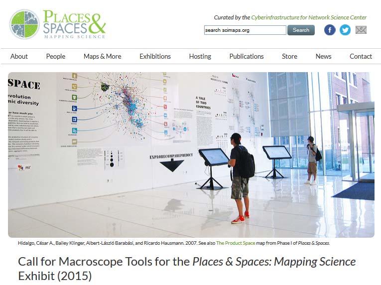
Exhibit Explanation. Places & Spaces: Mapping Science On Display at the Monroe County Public Library May 1 May 30, General Introduction
 Places & Spaces: Mapping Science On Display at the Monroe County Public Library May 1 May 30, 2007 Exhibit Explanation General Introduction Cartographic maps of physical places have guided mankind s explorations
Mapping the Structure and Diffusion of Scholarly Knowledge
 Mapping the Structure and Diffusion of Scholarly Knowledge Dr. Katy Börner Cyberinfrastructure for Network Science Center, Director Information Visualization Laboratory, Director School of Library and
040. Network Science: Theory, Tools, and Practice
 Börner, Katy. In Press. Network Science: Theory, Tools, and Practice. In William Sims Bainbridge, Ed. Leadership in Science and Technology: A Reference Handbook. Thousand Oaks, CA: Sage Publications 040.
INTERMEDIATE ALGEBRA, Chapter 2 Form A 109. For Exercises 1-4, solve each equation. 5. Decide whether
 INTERMEDIATE ALGEBRA, Chapter Form A 109 CHAPTER, FORM A NAME: INTERMEDIATE ALGEBRA SECTION: For Exercises 1-4, solve each equation. 1. ( x 3) 4x= x 8 4x 1.. 30 + 3 7( 3c) = 4( c 5) + 3c + 7 3. ( y ) c.
Climate Risk Visualization for Adaptation Planning and Emergency Response
 Climate Risk Visualization for Adaptation Planning and Emergency Response NCR Flood Fact Finding Workshop Ricardo Saavedra ricardo@vizonomy.com Social Media, Mobile, and Big Data St. Peter s Basilica,
Design and Update of a Classification System: The UCSD Map of Science
 Design and Update of a Classification System: The UCSD Map of Science Katy Börner 1,2 *, Richard Klavans 3, Michael Patek 3, Angela M. Zoss 1, Joseph R. Biberstine 1, Robert P. Light 1, Vincent Larivière
Sci2 Tool: A Tool for Science of Science Research and Practice" Tutorial
 Sci2 Tool: A Tool for Science of Science Research and Practice" Tutorial Dr. Katy Börner CNS & IVL, SLIS, Indiana University, Bloomington, Indiana, USA Royal Netherlands Academy of Arts and Sciences (KNAW),
Professional Development Grant Final Report. Attend and Present at the Annual Meeting of the Geological Society of America
 Professional Development Grant Final Report Attend and Present at the Annual Meeting of the Geological Society of America Michael G. Davis, Ph.D. Department of Physical Sciences College of Natural and
Utilizing GIS to Identify and Mobilize Interdisciplinary Disaster Reconnaissance Research Teams: The SSEER and ISEEER Platforms
 Utilizing GIS to Identify and Mobilize Interdisciplinary Disaster Reconnaissance Research Teams: The SSEER and ISEEER Platforms NSF-EAGER Award #1745611 Lori Peek, Director Mason Mathews and Haorui Wu,
MAA509: Quantum Computing and Information Introduction
 MAA509: Quantum Computing and Information Introduction November 7, 2016 November 7, 2016 1 / 19 Why make computers? Computation by hand is difficult and not very stimulating. Why not make a machine do
Software survey: VOSviewer, a computer program for bibliometric mapping
 Scientometrics (2010) 84:523 538 DOI 10.1007/s11192-009-0146-3 Software survey: VOSviewer, a computer program for bibliometric mapping Nees Jan van Eck Ludo Waltman Received: 31 July 2009 / Published online:
Surveying, Mapping and Remote Sensing (LIESMARS), Wuhan University, China
, Wuhan University, China") Name: Peng Yue Title: Professor and Director, Institute of Geospatial Information and Location Based Services (IGILBS) Associate Chair, Department of Geographic Information Engineering School of Remote
Name: Peng Yue Title: Professor and Director, Institute of Geospatial Information and Location Based Services (IGILBS) Associate Chair, Department of Geographic Information Engineering School of Remote
Mobility Analytics through Social and Personal Data. Pierre Senellart
 Mobility Analytics through Social and Personal Data Pierre Senellart Session: Big Data & Transport Business Convention on Big Data Université Paris-Saclay, 25 novembre 2015 Analyzing Transportation and
Consensus Algorithms for Camera Sensor Networks. Roberto Tron Vision, Dynamics and Learning Lab Johns Hopkins University
 Consensus Algorithms for Camera Sensor Networks Roberto Tron Vision, Dynamics and Learning Lab Johns Hopkins University Camera Sensor Networks Motes Small, battery powered Embedded camera Wireless interface
GIS-based Smart Campus System using 3D Modeling
 GIS-based Smart Campus System using 3D Modeling Smita Sengupta GISE Advance Research Lab. IIT Bombay, Powai Mumbai 400 076, India smitas@cse.iitb.ac.in Concept of Smart Campus System Overview of IITB Campus
Locating an Astronomy and Astrophysics Publication Set in a Map of the Full Scopus Database
 Locating an Astronomy and Astrophysics Publication Set in a Map of the Full Scopus Database Kevin W. Boyack 1 1 kboyack@mapofscience.com SciTech Strategies, Inc., 8421 Manuel Cia Pl NE, Albuquerque, NM
Cyberinfrastructure and CyberGIS: Recent Advances and Key Themes
 Cyberinfrastructure and CyberGIS: Recent Advances and Key Themes Shaowen Wang CyberInfrastructure and Geospatial Information Laboratory (CIGI) Department of Geography Department of Computer Science National
Abstract. Interoperable Framework for Mobile Dynamic Surveying based on open source components
 Interoperable Framework for Mobile Dynamic Surveying based on open source components Sergiusz Pawlowicz, Didier Leibovici, Richard Saull±, Mike Jackson, Chaoyu Ye, Wenchao Jiang, Natalie Adams 1, Suchith
Human Brain Networks. Aivoaakkoset BECS-C3001"
 Human Brain Networks Aivoaakkoset BECS-C3001" Enrico Glerean (MSc), Brain & Mind Lab, BECS, Aalto University" www.glerean.com @eglerean becs.aalto.fi/bml enrico.glerean@aalto.fi" Why?" 1. WHY BRAIN NETWORKS?"
ArcGIS for Desktop. ArcGIS for Desktop is the primary authoring tool for the ArcGIS platform.
 ArcGIS for Desktop ArcGIS for Desktop ArcGIS for Desktop is the primary authoring tool for the ArcGIS platform. Beyond showing your data as points on a map, ArcGIS for Desktop gives you the power to manage
Mapping the Structure and Evolution of Chemistry Research
 Mapping the Structure and Evolution of Chemistry Research Kevin W. Boyack *, Katy Börner ** and Richard Klavans *** * kboyack@mapofscience.com * Sandia National Laboratories, P.O. Box 5800, MS-1316, Albuquerque,
Harmonizing spatial databases and services at local and regional level
 Harmonizing spatial databases and services at local and regional level A. Ionita 1, M. Caian 2, V. Vassilev 3, V. Craciunescu 2, I. Nedelcu 4 1 Research Institute for Artificial Intelligence, Bucuresti,
Russell Hanson DFCI April 24, 2009
 DFCI Boston: Using the Weighted Histogram Analysis Method (WHAM) in cancer biology and the Yeast Protein Databank (YPD); Latent Dirichlet Analysis (LDA) for biological sequences and structures Russell
Welcome to. Session
 Welcome to Session 2006-07 The basics Status A1X (2KPU) and A1Y (2KRU) are level 1 courses in the Faculty of Physical Sciences, and are each worth 20 credits. A1X is taught in semester 1, and A1Y in semester
Dr. Steven Koch Director, NOAA National Severe Storms Laboratory Chair, WRN Workshop Executive Committee. Photo Credit: Associated Press
 Dr. Steven Koch Director, NOAA National Severe Storms Laboratory Chair, WRN Workshop Executive Committee 1 Photo Credit: Associated Press 1" 2" Much%Increased%Vulnerability%to% High6Impact%Weather% %even%before%2011!%
Twenty Years of Progress: GIScience in Michael F. Goodchild University of California Santa Barbara
 Twenty Years of Progress: GIScience in 2010 Michael F. Goodchild University of California Santa Barbara Outline The beginnings: GIScience in 1990 Major accomplishments research institutional The future
personal weather station
 personal weather station Master your own climate measurements on your smartphone TRAINING BOOK Pitch The Netatmo Personal Weather Station helps you master your own climate measurements on your smartphone.
SCAUG Community Maps Building a Living Atlas of the World
 SCAUG Community Maps Building a Living Atlas of the World Mark Stewart Topics: SCAUG ArcGIS Online Overview Community Maps Overview Community Maps Workflow Update Process Utilizing Your Contribution Community
geographic patterns and processes are captured and represented using computer technologies
 Proposed Certificate in Geographic Information Science Department of Geographical and Sustainability Sciences Submitted: November 9, 2016 Geographic information systems (GIS) capture the complex spatial
Archaeology & Digital Humanities
 WAYNE STATE UNIVERSITY Archaeology & Digital Humanities The D.I.R.T. on Big Data STRENGTHENING THE BIG DATA & ANALYTICS ECOSYSTEM WAYNE STATE UNIVERSITY Krysta Ryzewski Associate Professor of Anthropology
Data-Driven Network Neuroscience. Sarah Feldt Muldoon Mathematics, CDSE Program, Neuroscience Program DAAD, May 18, 2016
 Data-Driven Network Neuroscience Sarah Feldt Muldoon Mathematics, CDSE Program, Neuroscience Program DAAD, May 18, 2016 What is Network Neuroscience?! Application of network theoretical techniques to neuroscience
The Structure and Evolution of Sustainability Science
 The Structure and Evolution of Sustainability Science Luís M. A. Bettencourt Jasleen Kaur SFI WORKING PAPER: 2011-02-004 SFI Working Papers contain accounts of scientific work of the author(s) and do not
Editorial Introduction: Special Issue on Grids and Geospatial Information Systems
 EditorialIntroduction:SpecialIssueonGridsand GeospatialInformationSystems MarlonE.Pierce CommunityGridsLaboratory IndianaUniversity mpierce@cs.indiana.edu Abstract: Grids and Geospatial Information Systems(GIS)
YOUR CITY INSTITUTIONAL KNOWLEDGE
 2017 PLANNING COMMISSIONERS ACADEMY Free Tools & Resources for Planning Commissioners ERIC A. NELSON CHAIRMAN, CITY OF DANA POINT PLANNING COMMISSION JOEL ROJAS - DEVELOPMENT SERVICES DIRECTOR, SAN JUAN
SOCIAL MEDIA IN THE COMMUNICATIONS CENTRE
 SOCIAL MEDIA IN THE COMMUNICATIONS CENTRE Karen Gordon Gordon Strategy www.gordonstrategy.ca v 1 WHAT WE ARE GOING TO TALK ABOUT TODAY T h e s o c i a l m e d i a i n c i d e n t W h a t c a n h a p p
free psychic love reading chat psychics free love
 Keen's live psychic readings give you the insights you get a free psychic reading. You can connect with any psychic via online chat, email readings,. Chat Online With Our Experts Who Offer Horoscopes,
Basic Training Battlemind to Home Symposium. Sept
 Basic Training Battlemind to Home Symposium Sept 2017 1 What is Measuring Communities? A social indicators project which allows users to obtain military-specific information about communities strengths
Persistent Homology: Course Plan
 Persistent Homology: Course Plan Andrey Blinov 16 October 2017 Abstract This is a list of potential topics for each class of the prospective course, with references to the literature. Each class will have
Getting Started with Community Maps
 Esri International User Conference San Diego, California Technical Workshops July 24, 2012 Getting Started with Community Maps Shane Matthews and Tamara Yoder Topics for this Session ArcGIS is a complete
Conference panel Session 98, Defining Data Professionals A Geospatial Industry Perspective on Becoming a Data Professional
 Conference panel Session 98, Defining Data Professionals A Geospatial Industry Perspective on Becoming a Data Professional Dawn J. Wright, Environmental Systems Research Institute (aka Esri), Redlands,
Using Web Technologies for Integrative Drug Discovery
 Using Web Technologies for Integrative Drug Discovery Qian Zhu 1 Sashikiran Challa 1 Yuying Sun 3 Michael S. Lajiness 2 David J. Wild 1 Ying Ding 3 1 School of Informatics and Computing, Indiana University,
STScI at the AAS 231: January 2018, Washington, D.C.
 STScI at the AAS 231: January 2018, Washington, D.C. The Space Telescope Science Institute (STScI) will be at the 231st AAS meeting in Washington, D.C. with an exhibit booth and several associated events
Bringing high energy physics to the classroom with HY.P.A.T.I.A.
 EPJ Web of Conferences 71, 00137 (2014) DOI: 10.1051/ epjconf/ 20147100137 C Owned by the authors, published by EDP Sciences, 2014 Bringing high energy physics to the classroom with HY.P.A.T.I.A. Stylianos
Visualizing Uncertainty In Environmental Work-flows And Sensor Streams
 Visualizing Uncertainty In Environmental Work-flows And Sensor Streams Karthikeyan Bollu Ganesh and Patrick Maué Institute for Geoinformatics (IFGI), University of Muenster, D-48151 Muenster, Germany {karthikeyan,pajoma}@uni-muenster.de
2014 Arizona State University, School of Geographical Sciences and Urban Planning Lounsbury Travel Award. $350
 Heather A. Fischer Arizona State University School of Geographical Sciences and Urban Planning P.O. Box 875302 Tempe, AZ 85287-5302 (801) 870-3365 heather.fischer@asu.edu https://sites.google.com/a/asu.edu/heatherafischer/
Prairie Climate Centre Prairie Climate Atlas. Visualizing Climate Change Projections for the Canadian Prairie Provinces
 Prairie Climate Centre Prairie Climate Atlas Visualizing Climate Change Projections for the Canadian Prairie Provinces Acknowledgements About Us Dr. Danny Blair Dr. Ian Mauro Ryan Smith, MSc Dr. Hank Venema
Math Linear Algebra Spring Term 2014 Course Description
 Math 200 - Linear Algebra Spring Term 2014 Course Description February 6, 2014 Instructor: John Schmitt Office: Warner 311, Tel: Ext. 5952 E-mail: jschmitt@middlebury.edu Office Hours: Tuesday 1:30pm 3pm,
SPATIAL INFORMATION GRID AND ITS APPLICATION IN GEOLOGICAL SURVEY
 SPATIAL INFORMATION GRID AND ITS APPLICATION IN GEOLOGICAL SURVEY K. T. He a, b, Y. Tang a, W. X. Yu a a School of Electronic Science and Engineering, National University of Defense Technology, Changsha,
ArcGIS Earth for Enterprises DARRON PUSTAM ARCGIS EARTH CHRIS ANDREWS 3D
 ArcGIS Earth for Enterprises DARRON PUSTAM ARCGIS EARTH CHRIS ANDREWS 3D ArcGIS Earth is ArcGIS Earth is a lightweight globe desktop application that helps you explore any part of the world and investigate
Telescopes and Observatories. Parent Guide, page 1 of 2. OurStory: Exploring the Sky. Read the Directions sheets for step-by-step instructions.
 Parent Guide, page 1 of 2 Read the Directions sheets for step-by-step instructions. SUMMARY In this activity, children and adults will watch and discuss a short video about how people use telescopes. WHY
SA Geospatial Analysis Platform (GAP) Methodology*, collaborators & data sources
 Methodology*, collaborators & data sources") SA Geospatial Analysis Platform (GAP) Methodology*, collaborators & data sources Mesoframe CSIR, dti, the Presidency & GTZ Demarcation of South Africa into a grid of 50 Km 2 mesozones, nested within important
SA Geospatial Analysis Platform (GAP) Methodology*, collaborators & data sources Mesoframe CSIR, dti, the Presidency & GTZ Demarcation of South Africa into a grid of 50 Km 2 mesozones, nested within important
METHODS FOR IDENTIFYING PUBLIC HEALTH TRENDS. Mark Dredze Department of Computer Science Johns Hopkins University
 METHODS FOR IDENTIFYING PUBLIC HEALTH TRENDS Mark Dredze Department of Computer Science Johns Hopkins University disease surveillance self medicating vaccination PUBLIC HEALTH The prevention of disease,
Australian Earth Science Research Spatial Information Infrastructure
 AN ORGANISATION FOR A NATIONAL EARTH SCIENCE INFRASTRUCTURE PROGRAM Australian Earth Science Research Spatial Information Infrastructure Dr Robert Woodcock AuScope Grid - Director Outline Why build an
ArcGIS Earth an Intro
 ArcGIS Earth an Intro Chris Andrews Product Manager, 3D and ArcGIS Earth Brian Sims 3D Content Lead 3D across the Esri product family ArcGIS Pro 3D Analyst CityEngine ArcGIS for Server ArcGIS Online ArcGIS
Solve For I By A E Dooland READ ONLINE
 Solve For I By A E Dooland READ ONLINE If searched for the ebook Solve for i by A E Dooland in pdf form, in that case you come on to loyal site. We presented the complete variant of this ebook in txt,
Breaking News English.com Ready-to-Use English Lessons by Sean Banville
 Breaking News English.com Ready-to-Use English Lessons by Sean Banville 1,000 IDEAS & ACTIVITIES FOR LANGUAGE TEACHERS breakingnewsenglish.com/book.html Thousands more free lessons from Sean's other websites
GRAPHENE CONNECT. Biomedical Technologies
 GRAPHENE CONNECT Biomedical Technologies Thursday, 16 November 2017, 10:15-17:15 taking place during MEDICA/COMPAMED trade fair Messe Düsseldorf, Stockumer Kirchstraße 61, 40474 Düsseldorf, Germany, Hall
Arctic Spatial Data Infrastructure Enabling Access to Arctic Location-Based Information
 Arctic Spatial Data Infrastructure Enabling Access to Arctic Location-Based Information Arctic SDI Side Event Co-Chairs: Arvo Kokkonen Arctic SDI Board Chair & Director General, National Land Survey of
BINOMIAL COEFFICIENT IDENTITIES AND HYPERGEOMETRIC SERIES. Michael D. Hirschhorn
 BINOMIAL COEFFICIENT IDENTITIES AND HYPERGEOMETRIC SERIES Michael D Hirschhorn In recent months I have come across many instances in which someone has found what they believe is a new result in which they
Esri Overview for Mentor Protégé Program:
 Agenda Passionate About Helping You Succeed Esri Overview for Mentor Protégé Program: Northrop Grumman CSSS Jeff Dawley 3 September 2010 Esri Overview ArcGIS as a System ArcGIS 10 - Map Production - Mobile
Sparks CH301. Kinetic Theory of Gases. Day 4 LM 09 AND HW DUE WEDNESDAY 8:45 AM
 Sparks CH301 Kinetic Theory of Gases Day 4 LM 09 AND HW DUE WEDNESDAY 8:45 AM QUIZ: CLICKER QUESTION In a mixture of one mole of He and one mole of Ar, the partial pressure of the Ar compared to the partial
Newtonian 17.5-inch Optical Tube Assembly
 Newtonian 17.5-inch Optical Tube Assembly Kevin Phung 1, Jacob Hass 1, Victor Chen 2, Kevin Thompson 1, and Russell Genet 1, 3 1. California Polytechnic State University, San Luis Obispo, CA 2. University
The elements that make up our bodies formed from the violent explosions of massive
 Page 1 The elements that make up our bodies formed from the violent explosions of massive stars. The same shapes that we trace when we look up at the sky were marveled at centuries before us by the ancient
Introduction to Quantum Computing
 Introduction to Quantum Computing Petros Wallden Lecture 1: Introduction 18th September 2017 School of Informatics, University of Edinburgh Resources 1. Quantum Computation and Quantum Information by Michael
6.207/14.15: Networks Lecture 7: Search on Networks: Navigation and Web Search
 6.207/14.15: Networks Lecture 7: Search on Networks: Navigation and Web Search Daron Acemoglu and Asu Ozdaglar MIT September 30, 2009 1 Networks: Lecture 7 Outline Navigation (or decentralized search)
Myron Bander s Legacy at UC Irvine Myron Bander Memorial Symposium June 8, Dennis Silverman Department of Physics and Astronomy UC Irvine
 Myron Bander s Legacy at UC Irvine Myron Bander Memorial Symposium June 8, 2013 Dennis Silverman Department of Physics and Astronomy UC Irvine Myron Bander as Team Leader First of all, Myron and Gordon
Enabling Access to Arctic Location Based Information
 Enabling Access to Arctic Location Based Information Kevin Gallagher Arctic SDI Board Chair, United States Geological Survey Alaska Surveying and Mapping Conference, GeoJam 15 February 2017 What is Arctic
Intro to Info Vis. CS 725/825 Information Visualization Spring } Before class. } During class. Dr. Michele C. Weigle
 CS 725/825 Information Visualization Spring 2018 Intro to Info Vis Dr. Michele C. Weigle http://www.cs.odu.edu/~mweigle/cs725-s18/ Today } Before class } Reading: Ch 1 - What's Vis, and Why Do It? } During
Figure 1 ELL strategies in the science classroom (Carr, Sexton, and Lagunoff 2002) Paired/cooperative groups
 Paired/cooperative groups") Figure 1 ELL strategies in the science classroom (Carr, Sexton, and Lagunoff 2002) ELL strategy Paired/cooperative groups Background/prior knowledge Sample procedures Pair by same language: same level
Figure 1 ELL strategies in the science classroom (Carr, Sexton, and Lagunoff 2002) ELL strategy Paired/cooperative groups Background/prior knowledge Sample procedures Pair by same language: same level
Mike Sfraga, Director UA Geography Program Scott Rupp, Director SNAP Katie Kennedy, Outreach Coordinator UAGP
 Mike Sfraga, Director UA Geography Program Scott Rupp, Director SNAP Katie Kennedy, Outreach Coordinator UAGP What is SNAP? SNAP is a collaborative network of the University of Alaska, state, federal,
Bilinear Transformations via a Computer Algebra System
 Bilinear Transformations via a Computer Algebra System Tilak de Alwis talwis@selu.edu Department of Mathematics Southeastern Louisiana University Hammond, LA 70403 USA Abstract: In this paper, we will
Computer science research seminar: VideoLectures.Net recommender system challenge: presentation of baseline solution
 Computer science research seminar: VideoLectures.Net recommender system challenge: presentation of baseline solution Nino Antulov-Fantulin 1, Mentors: Tomislav Šmuc 1 and Mile Šikić 2 3 1 Institute Rudjer
Domain Maps: Purposes, History, Parallels with Cartography, and Applications
 Domain Maps: Purposes, History, Parallels with Cartography, and Applications Peter A. Hook Indiana University, School of Law, 211 South Indiana Ave., Bloomington, IN 47405 USA {pahook@indiana.edu} Abstract