Early Maps of the World VERSUS Early Maps of Science
|
|
|
- Bruno York
- 5 years ago
- Views:
Transcription


1 2


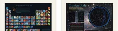
2 3 Early Maps of the World VERSUS Early Maps of Science 3D n-d Physically-based Abstract space Accuracy is measurable Accuracy is difficult Trade-offs have more to do with granularity Trade-offs indirectly affect accuracy 2-D projections are very accurate at local levels 2-D projections neglect a great deal of data Centuries of experience Decades of experience Geo-maps can be a template for other data Science maps can be a template for other data Kevin W. Boyack, UCGIS Summer Meeting, June,


3 Find your way Black Box Take terra bytes of data Find collaborators, friends Identify trends 5 6

4 7 8


5 9 10


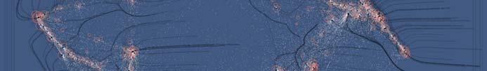
6 World Population The population map uses a quarter degree box resolution. Boxes with zero people are given in white. Darker shades of red indicate higher population counts per box using a logarithmic interpolation. The highest density boxes appear in Mumbai, with 11,687, people in the quarter degree block, Calcutta (10,816,010), 010) and Shanghai (8,628,088). 12
7 2007 IP Address Ownership This map shows IP address ownership by location. Each owner is represented by a circle and the area size of the circle corresponds to the number of IP addresses owned. The larges circle denotes MIT s holdings of an entire class A subnet, which equates to 16,581,375 IP addresses. The countries that own the most IP addresses are US (560 million), Japan (130 million), Great Britain (47 million) Scientific Productivity Shown is where science is performed today. Each circle indicates a geographic location at which scholarly papers are published. The larger the circle the more papers are produced. Boston, MA, London, England, and New York, NY are the top three paper production areas. Note the strong resemblance with the Night on Earth and the IP Ownership maps and the striking differences to the world population map. 14


.")
8 2000 Night on Earth This image shows city lights at night. It was composed from hundreds of pictures made by orbiting satellites. The seaboards of Europe, the eastern United States, and Japan are particularly well lit. Many cities exist near rivers or oceans so that goods can be exchanged cheaply by boat. The central parts of South America, Africa, Asia, and Australia are rather dark despite their high population density, see map to the left. 15 In 1870, Captain George Everest embarked to map India by triangulation. For generations, a vast network of repeating sightline triangles was meticulously measured and recorded (see map below). What resembles a pattern of eyelashes on the northern border represents the sightlines to stations built above treetops. While analyzing the triangles in the calculating offices of Calcutta, the mapmakers discovered the highest peak in the world: Mount Everest 16


9 17 Legal Citation Index, 1873 Citation Indexes for Science, 1955 Google,


10
11 21 22
12 23 24


13 25
14
15


16 31
17
18 35 36
19 37 38
20 40


21 41 42
22
23
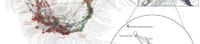
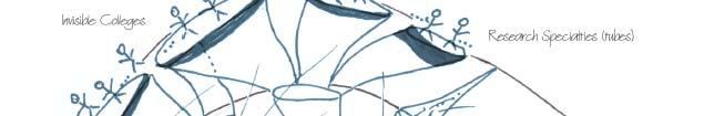
24 Areas Science of science as accumulation are tube shaped. of knowledge. Authors Scholarly are mortal. brick Papers laying. are immortal. This drawing attempts Monsters to Standing shows = the the on unknown structure the shoulders or of voids. of science. giants. Crust of science Impact can of represent funding on funding science (yellow). or usage. Many are interested Good to understand Densely bad knit years. the communities. dynamics of science. The importance of weak links. Hypothetical Model of the Evolution of Science - Daniel Zeller


25 49 50

 Mapping, Illuminating,")


26 Illuminated Diagram Display W. Bradford Paley, Kevin W. Boyack, Richard Kalvans, and Katy Börner (2007) Mapping, Illuminating, and Interacting with Science. SIGGRAPH Questions: Who is doing research on what topic and where? What is the footprint of interdisciplinary research fields? What impact have scientists? Contributions: Interactive, high resolution interface to access and make sense of data about scholarly activity. Large-scale, high resolution prints illuminated via projector or screen. Interactive touch panel


27 53 Science Maps in Expedition Zukunft science train visiting 62 cities in 7 months 12 coaches, 300 m long Opening was on April 23 rd, 2009 by German Chancellor Merkel 54


28 55 56
29 57 58
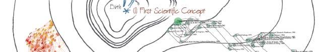
30 Science Puzzle Map for Kids by Fileve Palmer, Julie Smith, Elisha Hardy and Katy Börner, Indiana University, (Base map taken from Illuminated Diagram display by Kevin Boyack, Richard Klavans, and W. Bradford Paley.) 59 60

31 61 Activities: Solve the puzzle. Navigate to Earth Science. Identify major inventions. Place major inventors. Find your dream job on the map. Why is mathematics important? 62
32 63 64

 The Power of")
 The Power of")
 Science Maps as Visual Interfaces to")
 Science Forecasts (2013) How to Lie")


33 Mapping Science Exhibit 10 Iterations in 10 years The Power of Maps (2005) Science Maps for Economic Decision Makers (2008) The Power of Reference Systems (2006) Science Maps for Science Policy Makers (2009) The Power of Forecasts (2007) Science Maps for Scholars (2010) Science Maps as Visual Interfaces to Digital it Libraries i (2011) Science Maps for Kids (2012) Science Forecasts (2013) How to Lie with Science Maps (2014) Exhibit has been shown in 72 venues on four continents. Currently at - NSF, 10th Floor, 4201 Wilson Boulevard, Arlington, VA - Center of Advanced European Studies and Research, Bonn, Germany - Science Train, Germany - Cultural Dimensions of Innovation, UCD Conference, Dublin, Ireland 65 Db Debut of f5 th Iteration of Mapping Science Exhibit at MEDIA X was on May 18, 2009 at Wallenberg Hall, Stanford University,


34 67 This is the only mockup in this slide show. Everything else is available today.
35 Bollen, Johan, Herbert Van de Sompel, Aric Hagberg, Luis M.A. Bettencourt, Ryan Chute, Marko A. Rodriquez, Lyudmila Balakireva A Clickstream Map of Science. 69 Interactive Maps of Science Philanthropy 70


36 71 Interactive World and Science Map of S&T Jobs Angela Zoss, Michael Connover, Katy Börner (2010) 72


37 Council for Chemical Research Chemical R&D Powers the U.S. Innovation Engine. Washington, DC. Courtesy of the Council for Chemical Research


38 75 We would like to thank the map makers


 Tool and CI")
39 77 Computational Scientometrics Cyberinfrastructures Scholarly Database: 25 million scholarly records VIVO Research Networking Information Visualization Cyberinfrastructure Network Workbench Tool & Community Wiki Science of Science (Sci 2 ) Tool and CI Portal Epidemics Cyberinfrastructure 78


40 79
Types and Levels of Team (Network) Analysis
 Analysis") Types and Levels of Team (Network) Analysis Dr. Katy Börner Cyberinfrastructure for Network Science Center, Director Information Visualization Laboratory, Director School of Library and Information Science
Types and Levels of Team (Network) Analysis Dr. Katy Börner Cyberinfrastructure for Network Science Center, Director Information Visualization Laboratory, Director School of Library and Information Science
Cartographies of Science
 Cartographies of Science Katy Börner Visiting Scientist in Dirk Helbing s Group, SOMS, ETHZ Cyberinfrastructure for Network Science Center, Director Information Visualization Laboratory, Director School
Interactive Maps of S&T
 Interactive Maps of S&T Katy Börner Cyberinfrastructure for Network Science Center, Director Information Visualization Laboratory, Director School of Library and Information Science Indiana University,
How do we analyze and visualize science?
 Analysis and Visualization of Science Angela Zoss, M.S. Research Assistant, Cyberinfrastructurefor Network Science Center Doctoral Student, School of Library and Information Science Indiana University,
Human BioMolecular Atlas: Maps and Macroscopes
 Human BioMolecular Atlas: Maps and Macroscopes Katy Börner Victor H. Yngve Distinguished Professor of Information Science Director, Cyberinfrastructure for Network Science Center School of Informatics
1. Science/Economy/STEM is Global and needs to be understood globally (but optimized locally).
.") STEM: Individual, Local, and Global Flows and Activity Patterns Dr. Katy Börner Cyberinfrastructure for Network Science Center, Director Information Visualization Laboratory, Director School of Library
STEM: Individual, Local, and Global Flows and Activity Patterns Dr. Katy Börner Cyberinfrastructure for Network Science Center, Director Information Visualization Laboratory, Director School of Library
Towards Effective KM Tools
 Towards Effective KM Tools Dr. Katy Börner Cyberinfrastructure for Network Science Center, Director Information Visualization Laboratory, Director School of Library and Information Science Indiana University,
Exhibit Explanation. Places & Spaces: Mapping Science On Display at the Monroe County Public Library May 1 May 30, General Introduction
 Places & Spaces: Mapping Science On Display at the Monroe County Public Library May 1 May 30, 2007 Exhibit Explanation General Introduction Cartographic maps of physical places have guided mankind s explorations
Science Maps. Different Datasets Different Analyses and Visualizations Different User Groups
 Identifying Overlap, Gaps and Emerging Research Areas Using Multi-Level Science Maps Katy Börner Cyberinfrastructure for Network Science Center, Director Information Visualization Laboratory, Director
S701 Guest ectur Lecture Dr. Katy Börner Three Readings
 S701 Guest Lecture Dr. Katy Börner Cyberinfrastructure for Network Science Center, Director Information Visualization Laboratory, Director School of Library and Information Science Indiana University,
Science of Science Research and Tools Tutorial #05 of 12
 Science of Science Research and Tools Tutorial #05 of 12 Dr. Katy Börner Cyberinfrastructure for Network Science Center, Director Information Visualization Laboratory, Director School of Library and Information
Understanding (Big) Data by Using Macroscopes
 Data by Using Macroscopes") Understanding (Big) Data by Using Macroscopes Katy Börner Cyberinfrastructure for Network Science Center, Director Information Visualization Laboratory, Director Department of Information and Library Science
Understanding (Big) Data by Using Macroscopes Katy Börner Cyberinfrastructure for Network Science Center, Director Information Visualization Laboratory, Director Department of Information and Library Science
Plug and Play Macroscopes: Empowering Anyone To Convert Data Into Insights
 Plug and Play Macroscopes: Empowering Anyone To Convert Data Into Insights Katy Börner Victor H. Yngve Distinguished Professor of Information Science Director, Cyberinfrastructure for Network Science Center
Mapping the Structure
 Mapping the Structure and Dynamics of Science Dr. Katy Börner Cyberinfrastructure for Network Science Center, Director Information Visualization Laboratory, Director School of Library and Information Science
Analyzing and Visualizing Science
 Analyzing and Visualizing Science Katy Börner Royal Netherlands Academy of Arts and Sciences (KNAW), The Netherlands and Cyberinfrastructure for Network Science Center, Director Information Visualization
Phase 1 Cards. Phase 1. Phase 1. How many picnic areas does the park have? Write the answer near the legend.
 S T U D E N T H A N D O U T F Cards Write the map s title in the northwest corner above the map. How many picnic areas does the park have? Write the answer near the legend. 1 2 Draw a compass rose near
Student Handout. Write the map s title in the northwest corner of the map. How many picnic areas does the park have? Write the answer near the legend.
 Student Handout 1F Cards Write the map s title in the northwest corner of the map. How many picnic areas does the park have? Write the answer near the legend. 1 2 Draw a compass rose near the west edge
Explain the impact of location, climate, natural resources, and population distribution on Europe. a. Compare how the location, climate, and natural
 SS6G10 Explain the impact of location, climate, natural resources, and population distribution on Europe. a. Compare how the location, climate, and natural resources of Germany, the United Kingdom and
Where, on Earth, are you?
 Where, on Earth, are you? We all live on a big planet called Earth, of course. But where on Earth? And if you want to go to a different spot on Earth other than the spot you are in, how do you know which
21st Century Global Learning
 21st Century Global Learning A focus for 7th grade is on the ever-increasing global interactions in society. This focus includes a study of various societies and regions from every continent. We have already
Design and Update of a Classification System: The UCSD Map of Science
 Design and Update of a Classification System: The UCSD Map of Science Networks and Complex Systems Talk Series Indiana University, Bloomington, IN Sept 10,2012 Overview Motivation Design Validation Application
On the Move: Continental Drift and Plate Tectonic
 On the Move: Continental Drift and Plate Tectonic By Jim Cornish (1) Have you noticed that South America and Africa look like they could fit together like pieces in a jigsaw puzzle? If you have, you are
Researching Earth's Moving Crust
 Chapter 3 The Changing Earth Chapter Science Investigation Researching Earth's Moving Crust Find Out Do this activity to see what evidence exists today of plate movement or volcanic eruptions. newspapers,
REGIONAL SDI DEVELOPMENT
 REGIONAL SDI DEVELOPMENT Abbas Rajabifard 1 and Ian P. Williamson 2 1 Deputy Director and Senior Research Fellow Email: abbas.r@unimelb.edu.au 2 Director, Professor of Surveying and Land Information, Email:
UNIT 1: EARTH FORCES EARTH FORCES. If you think this planet we live on is a safe, solid lump of rock it s time to think again!
 UNIT 1: EARTH FORCES EARTH FORCES If you think this planet we live on is a safe, solid lump of rock it s time to think again! UNIT 1: EARTH FORCES EARTH FORCES Having investigated processes which form
2/25/2019. Taking the northern and southern hemispheres together, on average the world s population lives 24 degrees from the equator.
 Where is the world s population? Roughly 88 percent of the world s population lives in the Northern Hemisphere, with about half north of 27 degrees north Taking the northern and southern hemispheres together,
Global Spatial Data Infrastructure Association
 http://www.gsdi.org Global Spatial Data Infrastructure Association a global forum to support exchange of ideas and encourage joint activities at the global level Members: Think global, act local Organization:
Many Ways to Name a Place
 Your web browser (Safari 7) is out of date. For more security, comfort and Activityapply the best experience on this site: Update your browser Ignore Many Ways to Name a Place What are the names for the
Astronomy Review. Use the following four pictures to answer questions 1-4.
 Astronomy Review Use the following four pictures to answer questions 1-4. 1. Put an X through the pictures that are NOT possible. 2. Circle the picture that could be a lunar eclipse. 3. Triangle the picture
Name three countries in Europe.
 Name three countries in Europe. I will be able to identify the 5 themes of geography for Europe and locate the countries and capitals of Europe and the major physical features. People: Past: Through the
Simple Solutions Social Studies Level 2. Level 2. Social Studies. Help Pages
 Level 2 Social Studies 147 148 adobe houses with bricks made of clay and straw ancestor a family member who lived before us appoint choose; leaders can appoint others barter trading one thing for another
The future of SDIs. Ian Masser
 The future of SDIs Ian Masser Presentation Considers two questions relating to the future development of SDIs throughout the world Where have we got to now? Where should we go from here? Identifies four
1. The pictures below show the Sun at midday. Write winter, spring or summer under the correct picture.
 Test 2 1. The pictures below show the Sun at midday. Write winter, spring or summer under the correct picture. 2. Look carefully at the phases of the Moon. Number them (1 to 4) in the order that you would
Name: Date: Period: #: Chapter 1: Outline Notes What Does a Historian Do?
 Name: Date: Period: #: Chapter 1: Outline Notes What Does a Historian Do? Lesson 1.1 What is History? I. Why Study History? A. History is the study of the of the past. History considers both the way things
The Northwest Passage Grades 6-8
 The Northwest Passage Grades 6-8 Introduction European and North American governments and merchants expended a tremendous amount of effort during the 16 th through 19 th centuries in the quest to find
MR. GOFF S WORLD HISTORY UNIT ONE: GEOGRAPHY 5 THEMES OF GEOGRAPHY
 MR. GOFF S WORLD HISTORY UNIT ONE: GEOGRAPHY 5 THEMES OF GEOGRAPHY BYOD BRING YOUR OWN DEVICE IN SMALL GROUPS (3-4), USE YOUR ELECTRONIC DEVICE(S) AND DEFINE THE FOLLOWING VOCAB. WORDS 1. GEOGRAPHY 2.
Learning Target : Describe the purposes and uses of different types of maps.
 Learning Target : Describe the purposes and uses of different types of maps. Directions: 1. Below, place a where you think you are located. 2. In which continent are you located? 3. In which country are
The Geography Curriculum at Coston Primary
 The Geography Curriculum at Coston Primary Years Year 1 Year 2 Summer We are learning about where food is farmed and in The physical features of farms. The human features of farms. The characteristics
Crossing the Atlantic: Then and Now
 Your web browser (Safari 7) is out of date. For more security, comfort and Activitydevelop the best experience on this site: Update your browser Ignore Crossing the Atlantic: Then and Now How has the amount
Patterns on Earth 4.8C
 Have you ever made shadow puppets? If you put your hand between a flashlight and a wall, you will make a shadow. You might have made a rabbit shape or some other animal shape with your hands. Your hand
Year 34 B2 Geography - Continents and Oceans 2018 Key Skills to be covered: Taken from Level 3 Taken from Level 4
 Key Skills to be covered: Taken from Level 3 Taken from Level 4 Geographical Enquiry: I ask, Which PHYSICAL features does this place have? I ask, Which HUMAN features does this place have? I give reasons
How and where the TeraGrid supercomputing infrastructure benefits science.
 How and where the TeraGrid supercomputing infrastructure benefits science. Johan Bollen, 1,2 Geoffrey Fox, 1,3 Prashant Raj Singhal 1 1 School of Informatics and Computing, Indiana University. 2 Center
KIPP: Inspire Academy Social Studies Benchmark 1 PART I. Use the map of Missouri to answer questions 7-9.
 PART I 1) A physical map key shows: A. Climate B. Cities and borders C. Elevation and water depth D. Geographic features Use the map of Missouri to answer questions 7-9. 2) Lines of latitude: A. Are parallel
Unit 1: Geography and Social Studies Skills
 Unit 1: Geography and Social Studies Skills Standard(s) of Learning: WHI.1 The student will improve skills in historical research and geographical analysis by a) Identifying, analyzing, and interpreting
Exploring Europe. Continents of the World Geography Series
 Exploring Europe Continents of the World Geography Series Author: Michael Kramme, Ph.D. Consultants: Schyrlet Cameron and Carolyn Craig Editors: Mary Dieterich and Sarah M. Anderson COPYRIGHT 2012 Mark
Locating an Astronomy and Astrophysics Publication Set in a Map of the Full Scopus Database
 Locating an Astronomy and Astrophysics Publication Set in a Map of the Full Scopus Database Kevin W. Boyack 1 1 kboyack@mapofscience.com SciTech Strategies, Inc., 8421 Manuel Cia Pl NE, Albuquerque, NM
Knowledge and understanding Geographical skills. Sample pages. features people processes world places events environments characteristics
 1.1 What is geography? Knowledge and understanding Geographical skills verbal linguistic visual spatial 1 Give two reasons why it is important to study geography. 2 Use words from the box below to complete
Range of Opportunities
 Geograhy Curriculum Cropwell Bishop Primary School Range of Opportunities Year 1 Year 2 Year 3 Year 4 Year 5 Year 6 All Key Stage 1 Key Stage 2 Investigate the countries and capitals of the United Kingdom.
Word Cards. 2 map. 1 geographic representation. a description or portrayal of the Earth or parts of the Earth. a visual representation of an area
 Name: Date: Hour: Word Cards 1 geographic representation a description or portrayal of the Earth or parts of the Earth Example: A map is a representation of an actual location or place. 2 map a visual
Compact guides GISCO. Geographic information system of the Commission
 Compact guides GISCO Geographic information system of the Commission What is GISCO? GISCO, the Geographic Information System of the COmmission, is a permanent service of Eurostat that fulfils the requirements
GSDI Global Spatial Data Infrastructure. Convergences between Geo Spatial Communities: key decision for decision making
 GSDI Global Spatial Data Infrastructure Convergences between Geo Spatial Communities: key decision for decision making April 14 th 2010 Bas Kok GSDI Past-President Director of International Affairs, Dutch
Geography and World Cultures
 Core Geography and World Cultures Geography and World Cultures offers a tightly focused and scaffolded curriculum that enables students to explore how geographic features, human relationships, political
GEOGRAPHY CURRICULUM OVERVIEW
 GEOGRAPHY CURRICULUM OVERVIEW Geographical knowledge Progression Statement Autumn Spring Summer Year 1 UK and Local Area: Physical Themes: Name, locate and identify characteristics of the 4 countries and
The structure of the Earth and how its motion creates the seasons. The landforms of the earth and the forces that shape the land.
 The structure of the Earth and how its motion creates the seasons. The landforms of the earth and the forces that shape the land. The role of wind and water in creating climate. The different climate and
National Geographic Australia: Continent Maps (NG Continent Maps) By National Geographic Society READ ONLINE
 By National Geographic Society READ ONLINE") National Geographic Australia: Continent Maps (NG Continent Maps) By National Geographic Society READ ONLINE If you are searching for a ebook by National Geographic Society National Geographic Australia:
National Geographic Australia: Continent Maps (NG Continent Maps) By National Geographic Society READ ONLINE If you are searching for a ebook by National Geographic Society National Geographic Australia:
In the space below, write an explanation for why we observe phases of the moon, based upon your current knowledge:
 IDS 102 Phases of the Moon PART II In the space below, write an explanation for why we observe phases of the moon, based upon your current knowledge: As you discovered yesterday, when we observe the Earth
... Asia. Based on Bloom s Taxonomy. Human & Movement. Location Place. Regions. Environment. Interactions
 ... Asia Location Place Human & Environment Interactions Movement Regions LEVEL 1 Knowledge Match Show or Label List Information Recall Details (5Ws + H) Find Information LEVEL 2 Comprehension LEVEL 3
Researching Earth's Moving Crust
 Chapter 3 The Changing Earth Chapter Science Investigation Researching Earth's Moving Crust Find Out Do this activity to see what evidence exists today of plate movement or volcanic eruptions. newspapers,
Antelope Island State Park International Dark Sky Park Annual Report 2018
 Antelope Island State Park International Dark Sky Park Annual Report 2018 Photo by Ryan Andreasen Antelope Island State Park IDA Contact: Wendy Wilson Assistant Park Manager wendywilson@utah.gov 801-230-6155
Downloaded from
 GIST OF THE LESSON: General patternsof population distribution in the world, density of population, factors influencing the distribution of population, population growth, trends in population growth, doubling
WELCOME TO GCSE GEOGRAPHY WHERE WILL IT TAKE US TODAY?
 WELCOME TO GCSE GEOGRAPHY WHERE WILL IT TAKE US TODAY? What is our challenge? X WHAT IS THE GLOBAL PATTERN OF URBAN GROWTH? TOPIC 5: URBAN FUTURES 5.1: WHY DO MORE THAN HALF OF THE WORLD S POPULATION
Norwich City Schools Social Studies 6
 Social Studies 6 Topic: Maps and Globes and Graphs and Time Transferable Concepts: change 3: Geography Geography Geographers use maps, globes, and graphs to study the Earth and everything on it. Types
Geospatial Information and Services for Disasters (GIS4D)
") Geospatial Information and Services for Disasters (GIS4D) 31 July 2017 Tae Hyung KIM ICT and Disaster Risk Reduction Division (IDD) UNESCAP 1 About ESCAP Who is ESCAP? United Nations Economic and Social
Geospatial Information and Services for Disasters (GIS4D) 31 July 2017 Tae Hyung KIM ICT and Disaster Risk Reduction Division (IDD) UNESCAP 1 About ESCAP Who is ESCAP? United Nations Economic and Social
Geography. Programmes of study for Key Stages 1-3
 Geography Programmes of study for Key Stages 1-3 February 2013 Contents Purpose of study 3 Aims 3 Attainment targets 3 Subject content 4 Key Stage 1 4 Key Stage 2 5 Key Stage 3 6 2 Purpose of study A high-quality
AP Human Geography Summer Homework 2016 JW Mitchell High School Mrs. Daniel
 AP Human Geography Summer Homework 2016 JW Mitchell High School Mrs. Daniel hdaniel@pasco.k12.fl.us Welcome to A.P. Human Geography. I am excited that you decided to take this journey to learn more about
I CAN STATEMENTS 6TH GRADE SOCIAL STUDIES
 6TH GRADE SOCIAL STUDIES I can compare historical issues involving rights, roles and statues of individuals. I can describe the relationships among specialization, division of labor, productivity of workers
How Astronomers Learnt that The Heavens Are Not Perfect
 1 How Astronomers Learnt that The Heavens Are Not Perfect Introduction In this packet, you will read about the discoveries and theories which changed the way astronomers understood the Universe. I have
ELEMENTS OF BASIC WORLD GEOGRAPHY TABLE OF CONTENTS UNIT 1 THE BASICS OF GEOGRAPHY AND NORTH AMERICA
 TABLE OF CONTENTS UNIT 1 THE BASICS OF GEOGRAPHY AND NORTH AMERICA IMPORTANT WORDS TO KNOW... 1 CHAPTER 1 THE BASICS OF GEOGRAPHY GEOGRAPHY... 2 TOOLS OF GEOGRAPHY... 3 EARTH...4 SEASONS, CLIMATE, AND
Our Lady Immaculate Catholic Primary School History and Geography Curriculum Map Would the Bog Baby survive in Liverpool?
 Year 1 and 2 - *Year 1 and 2 work on a two year cycle due to mixed classes Autumn 1 National Curriculum link: Human and physical geography - identify seasonal and daily weather patterns in the United Kingdom
MR. JOHNSON S. Geography OHIO COUNTY MIDDLE SCHOOL
 MR. JOHNSON S Geography OHIO COUNTY MIDDLE SCHOOL CHAPTER 1 Geography The science of geography is likely the oldest of all sciences. Geography is the answer to the question that the earliest humans asked,
Map Skills Scavenger Hunt
 Map Skills Scavenger Hunt Introduction to: Continents Cardinal Directions Relative Location Equator and Prime Meridian Hemispheres Reading a Political Map Reading a Physical Map Idea: This product includes
Introduction to Human Geography. Unit 1: It s Nature and Perspective
 Introduction to Human Geography Unit 1: It s Nature and Perspective Questions that Geography addresses: Where are things located? Why are they important? How are places related? How are places connected?
Unit 1 The Basics of Geography. Chapter 1 The Five Themes of Geography Page 5
 Unit 1 The Basics of Geography Chapter 1 The Five Themes of Geography Page 5 Geography comes from the Greek word geographia, which means to describe the earth. Geography is the study of the distribution
Maps. All Kinds of Maps 104 words. How to Draw a Map 105 words. The Difference Between Maps and Globes 108 words. Learn About Maps 96 words
 ARTICLE-A-DAY Maps 8 Articles Check articles you have read: All Kinds of Maps 104 words How to Draw a Map 105 words The Difference Between Maps and Globes 108 words Learn About Maps 96 words Seven Large
Exploring North America
 Exploring North America Continents of the World Geography Series Author: Michael Kramme, Ph.D. Consultants: Schyrlet Cameron and Carolyn Craig Editors: Mary Dieterich and Sarah M. Anderson COPYRIGHT 2012
SCIENCE IN THE NEWS Plate Tectonics
 SCIENCE IN THE NEWS Plate Tectonics From VOA Learning English, this is Science in the News. I m Anna Matteo. And I m Christopher Cruise. Scientists who study the Earth tell us the continents and ocean
Geography Progression
 Geography Progression This document aims to track expectations for History within George Grenville Academy. What the National Curriculum says: KS1: Locational Knowledge: Name and locate the world s 7 continents
El Niño / Southern Oscillation
 El Niño / Southern Oscillation Student Packet 2 Use contents of this packet as you feel appropriate. You are free to copy and use any of the material in this lesson plan. Packet Contents Introduction on
CANBERRA SECONDARY SCHOOL Preliminary Examination 2
 CANBERRA SECONDARY SCHOOL 2015 Preliminary Examination 2 Secondary Four (Normal Academic) COMBINED HUMANITIES 11 August 2015 Geography Elective (2194/02) 1 hour 40 minutes 10.30 12.10 Name: ( ) Class:
January 2018 Special Preview Edition
 January 2018 Special Preview Edition What s inside this booklet? The contents you ll explore 2 Americas 4 Europe 6 Far East & Oceania 8 Central & South Asia 10 Africa & Middle East 12 International 14
Chapter 1 Section 2. Land, Water, and Climate
 Chapter 1 Section 2 Land, Water, and Climate Vocabulary 1. Landforms- natural features of the Earth s land surface 2. Elevation- height above sea level 3. Relief- changes in height 4. Core- most inner
Central Valley School District Social Studies Curriculum Map Grade 7. August - September
 August - September Geographical/Historical Skills Identify and analyze timelines. Construct and use cause and effect charts. Differentiate between fact and opinion. Use of word webs, flip charts, outlines
SAMPLE. Succeeding in Social Studies 5 6 TH IN A SERIES OF 7. Years 5 9. Written by Valerie Marett. CORONEOS PUBLICATIONS Item No 508
 AUSTRALIAN HOMESCHOOLING SERIES Succeeding in Social Studies 5 6 TH IN A SERIES OF 7 Years 5 9 Written by Valerie Marett CORONEOS PUBLICATIONS Item No 508 Contents Notes to Parents.2 Latitude and Longitude...3
LOUISIANA STUDENT STANDARDS FOR SOCIAL STUDIES THAT CORRELATE WITH A FIELD TRIP TO DESTREHAN PLANTATION KINDERGARTEN
 LOUISIANA STUDENT STANDARDS FOR SOCIAL STUDIES THAT CORRELATE WITH A FIELD TRIP TO DESTREHAN PLANTATION KINDERGARTEN Standard 2 Historical Thinking Skills Students distinguish between events, people, and
Continental Drift and Plate Tectonics
 Continental Drift and Plate Tectonics As you work through the following slides of information, make sure you use the information to complete the tasks on your worksheet. By the end of the PDF, you should
Oceans. Places. People
 Places 1 If we look at our planet from a long way away, it is. a red b yellow c white d blue 2 The nearest place to Easter Island is. a Pitcairn b Chile c Australia d Tahiti 3 Near Oceania is a group of
Michael Harrigan Office hours: Fridays 2:00-4:00pm Holden Hall
 Announcement New Teaching Assistant Michael Harrigan Office hours: Fridays 2:00-4:00pm Holden Hall 209 Email: michael.harrigan@ttu.edu Guofeng Cao, Texas Tech GIST4302/5302, Lecture 2: Review of Map Projection
Your web browser (Safari 7) is out of date. For more security, comfort and the best experience on this site: Update your browser Ignore
 is out of date. For more security, comfort and the best experience on this site: Update your browser Ignore") Your web browser (Safari 7) is out of date. For more security, comfort and the best experience on this site: Update your browser Ignore ISTHMU S tombolo For the complete encyclopedic entry with media resources,
Your web browser (Safari 7) is out of date. For more security, comfort and the best experience on this site: Update your browser Ignore ISTHMU S tombolo For the complete encyclopedic entry with media resources,
We The People Houghton-Mifflin
 First Grade Curriculum SOCIAL STUDIES We The People Houghton-Mifflin -- 2000 ALL ABOUT FAMILIES Identify family members, correlate names with relationships Compare and contrast similarities and differences
September 14, 2013 Objective: How does geography impact history? What important features exist that have shaped societies?
 Lowenhaupt 1 September 14, 2013 Objective: How does geography impact history? What important features exist that have shaped societies? Warm-Up: In your binder, answer the following question: Imagine you
What are Latitude and Longitude?
 What are Latitude and Longitude? By Encyclopaedia Britannica, adapted by Newsela staff on 08.29.17 Word Count 959 Level 950L A few miles from Quito, Ecuador's capital, is the equator line. It is located
Holy Trinity 3-16 School. Geography Overview (Primary)
") Holy Trinity 3-16 School Key Stage 1 Geography Overview (Primary) Year Autumn 1 Autumn 2 Spring1 Spring 2 Summer 1 Summer 2 Y1 Dear Zoo Castles Gadgets and Gizmos (UK) Name, locate and identify characteristics
Holy Trinity 3-16 School Key Stage 1 Geography Overview (Primary) Year Autumn 1 Autumn 2 Spring1 Spring 2 Summer 1 Summer 2 Y1 Dear Zoo Castles Gadgets and Gizmos (UK) Name, locate and identify characteristics
2011, 1998, 1987 Copyright by Remedia Publications, Inc. All Rights Reserved. Printed in the U.S.A.
 See the world REM 129A A Teaching Resource From 2011, 1998, 1987 Copyright by Remedia Publications, Inc. All Rights Reserved. Printed in the U.S.A. The purchase of this product entitles the individual
Geography Route Planner
 Geography Route Planner Introduction to Route Planners Route Planners outline the Key Stages 1-3 curriculum to be taught within each campus of the Bury St Edmunds Trust. Each Route Planner has been designed
18.1 Earth and Its Moon Earth s shape and orbit Earth s shape Earth s orbit around the Sun
 18.1 Earth and Its Moon Revolving around Earth at a distance of 384,400 kilometers is our only moon. Since the invention of spacecraft, our knowledge of Earth and the Moon has grown tremendously. In fact,
YEAR 7 REVISION BOOKLET
 YEAR 7 REVISION BOOKLET Assessment checklist 1. To be able to define Geography. 2. Give examples of what we study in geography 3. Group what we study into the three major areas of geography 4. To be able
Grade Four Content Overview
 Grade Four Content Overview Physical features Regions Contributions of the states Our Country: Geography and Regions Coastal and inland communities Famous landmarks Physical and human characteristics Local,
Unit 1, Lesson 2. What is geographic inquiry?
 What is geographic inquiry? Unit 1, Lesson 2 Understanding the way in which social scientists investigate problems will help you conduct your own investigations about problems or issues facing your community
Sample. Contents SECTION 1: PLACE NAMES 6 SECTION 2: CONNECTING TO PLACES 21 SECTION 3: SPACES: NEAR AND FAR 53
 Contents Teachers' Notes 4 National Curriculum Links 5 SECTION 1: PLACE NAMES 6 Teachers' Notes 7-8 Activities Names Of Places 9 Place Names Are Important 1 10 Place Names Are Important 2 11 The Meanings
What Is a Globe? Hemispheres. Main Idea Globes and maps provide different ways of showing features of the earth. Terms to Know
 r Main Idea Globes and maps provide different ways of showing features of the earth. Terms to Know hemisphere latitude longitude scale bar scale relief elevation contour line What Is a Globe? A globe is