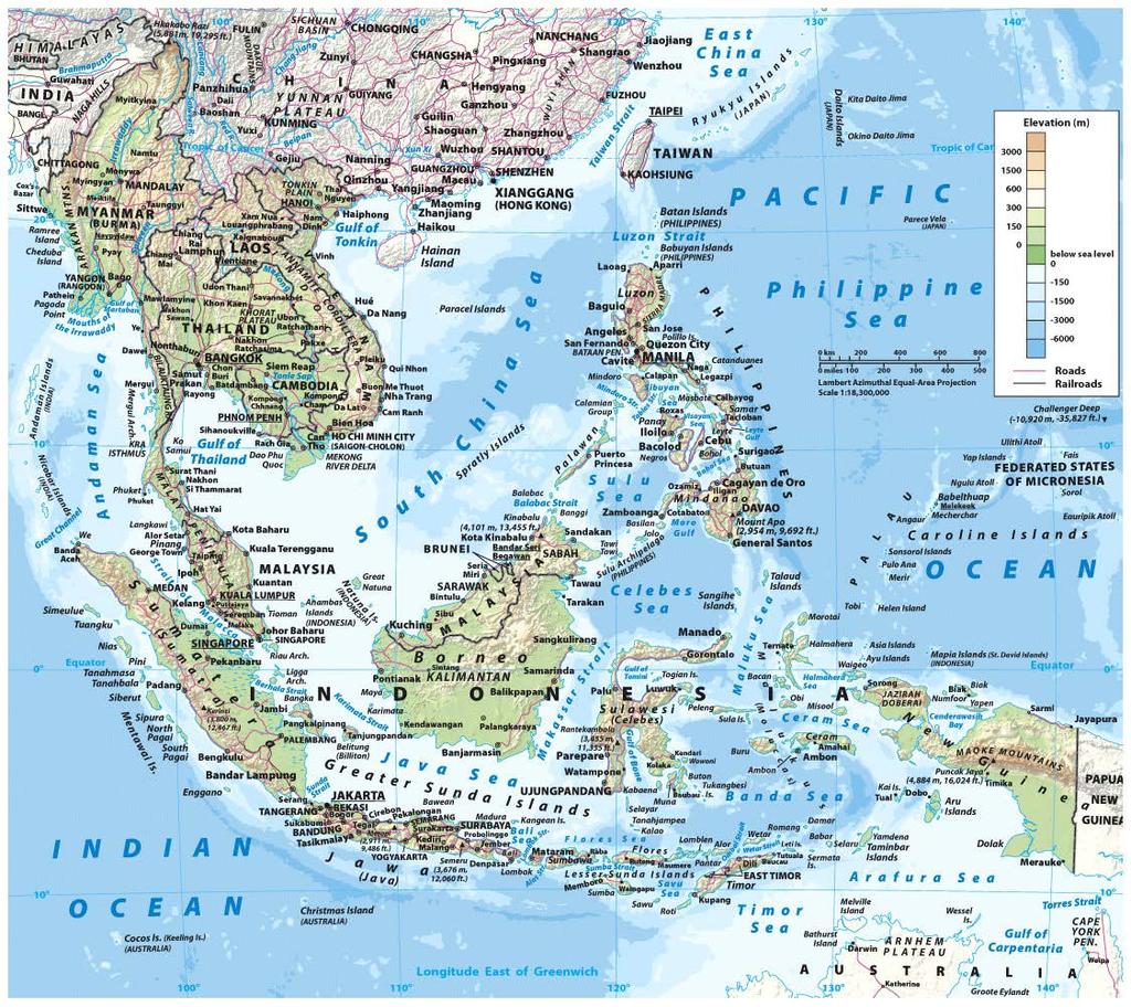
Chapter 10A: The Southeast Asian Realm
|
|
|
- Eileen Ramsey
- 6 years ago
- Views:
Transcription
1 Geography: Realms, Regions and Concepts 15 th Edition By de Blij and Muller Chapter 10A: The Southeast Asian Realm
2

3 A Geographic Overview Mainland & Insular physiographies Realm s Giant: Indonesia Size of area & population Borders of the realm India & China: source of immigrants, cultural infusion, economic interaction & more Concept Caching: Geography Textbooks and Atlases, Malang, Indonesia
4 Southeast Asia s Physical Geography Part of the Pacific Ring of Fire 2004 undersea earthquake & tsunami of Indian Ocean Volcanic eruptions: some have provided a better understanding of the complex climate system High relief realm Both on mainland & insular regions
5 Southeast Asia s Physical Geography: Exceptional Borneo mini-continent No volcanoes & negligible tremors Slab of ancient crust uplifted above sea level & subsequently eroded Ecosystems Equatorial rainforests once a sanctuary to countless plant & animal species Today, much is destroyed by logging, roads & farms


6 Palm-Oil Plantations and Versatile palm oil Today, very lucrative agricultural crop High yields & demand Rising prices Plantation expansion single largest threat to tropical forests & habitat Pressures for sustainability Deforestation Concept Caching: Indonesia's Fertile Countryside
7 Southeast Asia s Physical Geography: Relative Location and Biodiversity Destination for migrating species Animal & human migrations during shifting climactic periods or new modes of transportation Know for its biodiversity: estimates that 10% of world s plant & animals species are found there
8 Southeast Asia s Physical Geography: Well-endowed with moisture Population distribution highlights relationship between people & rivers Not just for water & agriculture Also as transportation arteries Coastal clusters at river deltas Four Major Rivers
9 Southeast Asia s Physical Geography: Four Major Rivers The Mighty Mekong Source in China s Tibetan Plateau Borders 5 of the realm s countries Supports farm & fishing livelihoods Upstream politics China s dam projects Managing flow volumes Intra-realm development projects

10 Southeast Asia s Physical Geography: Rivers and States Other rivers in the realm are local Red river of Vietnam & its capital Hanoi Chao Phraya River in Thailand & its capital Bangkok Irrawaddy River in Myanmar with its largest city, Yangon, sitting on the delta Four Major Rivers

11 Population Geography Indonesia s noteworthy Javan population cluster More than half the country s population Fertile volcanic soils, ample water & warmth Other clusters are fastgrowing urban areas Concept Caching: Java, Indonesia
12 Population Geography: Common stock with local ethnic/cultural groups Mainland spatial coincidence: major ethnic groups & political states Island nations ethnic groups In both, minorities present in remote peripheries Uplands or dense forests The Ethnic Mosaic
13 Population Geography: Some major ethnic minorities come from outside the realm South Asian peoples Some during European colonial period Others from early Buddhist migrations Immigrants

14 Population Geography: Long history of migration out of China Overseas Chinese concentration in cities Chinatowns Today the realm has more than half the world total Tensions with local ethnic majorities The Chinese
15 Regional Issue: The Chinese Presence in Southeast Asia THE CHINESE ARE TOO INFLUENTIAL! Chinese privilege & separateness Chinese act on their own behalf, not as part of the country that they live & work in Chinese exploit Southeast Asian opportunities & shared resources THE CHINESE ARE INDISPENSIBLE! All minorities have troubles Others are resentful of Chinese resourcefulness & success Chinese aloofness depends on the state context Chinese have made great contributions

16 Population Geography: Religions of Southeast Asia Historic crossroads of religions Hinduism & Buddhism from South Asia Islam from Southwest Asia Leads to great cultural diversity Different countries trend toward one religious system, yet presence of other significant religious groups Much cultural expression has been through infusion of foreign elements Concept Caching: Hindu Balinese Dancers of Ubud, Indonesia
17 Colonialism s Heritage: How the Political Map Evolved Europeans arrived to a politically fragmented realm Mainland river basins & plains as well as the islands produced a cultural diversity of societies European colonization involved divide & rule Out of that strategy they forged comparatively large, multicultural states Foreign intervention created the contemporary political map
18 Colonialism s Heritage: How the Political Map Evolved: French Indochina Southeast Asian empire called Indochina Indo- referred to South Asian cultural imprints Five French dependencies into three political states Vietnam Laos Cambodia The Colonial Imprint

19 Colonialism s Heritage: How the Political Map Evolved: British Imperialism Burma: part of the South Asian British Empire Not part of South Asian religious-borne partition Malaya: system of colonies & protectorates Malaya refers to the geographic area of the Malaysian peninsula Eventually became complex Malaysian Federation The Colonial Imprint
20 Colonialism s Heritage: How the Political Map Evolved: The Colonial Imprint Netherlands East Indies Spice Islands : lucrative spice commerce between Arab, Indian & Chinese traders Europeans great lengths to control the trade Spices to conserve food & add flavor Very high demand & thus very lucrative in Europe Jawa: the focus of Dutch colonial administration Dutch East India Company & the Dutch government extended influence over the smaller islands overtime Helped to pave the way for creation of the realm s largest state
21 Colonialism s Heritage: How the Political Map Evolved: The Colonial Imprint From Spain to the United States Spanish control of the Philippines Spread Catholicism & stave off Islamic incursions in the south Manila: a profitable way-station in travel across the Pacific Spanish-American war Already the Spanish were facing indigenous uprising Spain forced to settle following the brief war Ceded the Philippines to the US Local revolt for a time, but ultimately unsuccessful

22 Southeast Asia s Emerging Markets: Singapore s Centrality Leading node, or point of connectivity to wider economic network Top-tier world city due to its international linkages & global influence Symbol of modernity Skyline, industries & economic prowess Concept Caching: Singapore Entrepôt Exceptional regional position: Relative location for trade & shipping Physiography with large & deep natural harbor
23 Southeast Asia s Emerging Markets: Prospects of Realmwide Integration: ASEAN ASEAN, Association of Southeast Asian Nations Supranational organization with goals of realmwide political stability & increased regional integration Constant challenges Diversity of its member-states Economic & cultural differences Conflict between member-states Cultural contention & competing territorial claims Environmental problems: realmwide pollution
24 Southeast Asia s Emerging Markets: Prospects of Realmwide Integration: ASEAN AFTA, the ASEAN Free Trade Agreement Organization s expansion into the economic domain Lowering of tariffs has encourage a intra-realm trade boom Realm & foreign spheres of influence Previously integrated into the Japanese empire & the Yen bloc Chinese global resurgence AFTA allows it to hold its own, somewhat Integration via Chinese investment & infrastructure
25 States and Boundaries Boundaries as invisible vertical planes extending into the air & below the ground Their most tangible feature is as lines on the map Contracts between states Treaties contain the definition of boundary segments referring to landforms or specific terrain Surveyors translate descriptions into lines in a process called delimitation Finally, states mark stretches of their border with tangible barriers in a process called demarcation
26 States and Boundaries: Classifying Boundaries Types of boundaries: Physiographic: conform to elongated features of the natural landscape Ethnocultural: coincide with historic breaks or transitions in the cultural landscape Geometric: simply straight lines defined by endpoints History of realm s boundaries Most defined by European colonial powers Does more judiciously than elsewhere, but still cause problems

27 States and Boundaries: Boundaries in Changing Times Antecedent boundary: existing before the cultural landscape emerged Subsequent boundary: evolved as the cultural landscape took shape Superimposed boundary: drawn across an existing cultural landscape, often with little consideration of pre-existing patterns Relict boundary: border that has ceased to function but for its evident imprint on the cultural landscape
28 States and Boundaries: State and Territorial Morphology Territorial morphology: the shape of a state s territory Affects a state s condition & even survival Five dominant territorial configurations: 1. Compact states: near round or rectangular shapes with no major indentations
29 States and Boundaries: State and Territorial Morphology Territorial configurations: 2. Protruded states: substantial, usually compact territory with an extended peninsular corridor 3. Elongated states: territorial dimensions where length is much greater than the average width; result in cultural & environmental transitions
30 States and Boundaries: State and Territorial Morphology Territorial configurations: 4. Fragmented states: two or more territorial units separated by foreign territory or substantial body of water 5. Perforated states: completely surrounded by the territory of another state; appear as a hole in another state
The study of Geography and the use of geographic tools help us view the world in new ways.
 S How does Geography help us understand our world? What factors shape the Earth s different environments? 7.1.9 7.2.9 BIG IDEAS COMPETENCIES Text pages or The study of Geography and the use of geographic
MARS AREA SCHOOL DISTRICT CURRICULUM GRADE: Grade 4
 MARS AREA SCHOOL DISTRICT CURRICULUM GRADE: Grade 4 Course Title: Social Studies Brief Description Overview: Students will explore the history, geography, government, and economy of the United States with
Chapter 24 Test on Southeast Asia
 Name Score Chapter 24 Test on Southeast Asia Part 1 - Multiple Choice (24 pts.) Read the following statements carefully. Select and circle the most correct choice from among the choices provided. 1. Which
Thursday, April 27, 17
 Thursday, April 27, 17 Geography of Southeast Asia Objec-ve: Understand the geographical differences between the mainland region and the insular region of Southeast Asia. Do Now: What is the capital of
By Geri Flanary To accompany AP Human Geography: A Study Guide 3 rd edition By Ethel Wood
 Session 1 By Geri Flanary To accompany AP Human Geography: A Study Guide 3 rd edition By Ethel Wood WHAT IS DEMOGRAPHY? It is the scientific or statistical study of population. It comes from the Greek
BASINS RIVER. Luzon. Mekong. Java. Delta. Phraya. Chao. Delta. Malaya. Coast. West. Irrawaddy. Delta
 Part II Hinterlands Hinterlands 75 Geography gives logic to the otherwise fragmented national economic histories of Southeast Asia. Over the very long term since 1850 the region s economic development
Wednesday, May 23, 2018
 Wednesday, May 23, 2018 Physical Geography of West Africa Objective: Summarize the main geographic aspects of each country in West Africa. Understand each country s development pattern and their current
UNIT 4: POLITICAL ORGANIZATION OF SPACE
 UNIT 4: POLITICAL ORGANIZATION OF SPACE Advanced Placement Human Geography Session 1 ADVANCED PLACEMENT HUMAN GEOGRAPHY REVIEW SESSIONS: UNIT FOUR By Geri Flanary To accompany AP Human Geography: A Study
September 14, 2013 Objective: How does geography impact history? What important features exist that have shaped societies?
 Lowenhaupt 1 September 14, 2013 Objective: How does geography impact history? What important features exist that have shaped societies? Warm-Up: In your binder, answer the following question: Imagine you
South, Southeast, and East Asia. Physical Geography
 South, Southeast, and East Asia Physical Geography Mountains v Mountains are important in Asia because they influence: A. Population patterns B. Movement of people and goods C. Climate Mountains v The
Chapter 12: Pacific Realm and Polar Futures
 Geography: Realms, Regions and Concepts 15 th Edition By de Blij and Muller Chapter 12: Pacific Realm and Polar Futures Defining the Realm Sea Hemisphere: seas covering nearly an entire hemisphere Fragmented,
Name three countries in Europe.
 Name three countries in Europe. I will be able to identify the 5 themes of geography for Europe and locate the countries and capitals of Europe and the major physical features. People: Past: Through the
Physical Geography of East Asia
 Physical Geography of East Asia Satellite View of China Landforms of China China s Geography China Miles 0 250 500 1,000 1,500 2,000 United States 3 rd largest country in the world. Comparable to the US
Item Specifications Summary 7 th grade World Geography Assessment
 Item Specifications Summary 7 th grade World Geography Assessment 2013-14 Structure: 65 multiple choice questions (15 field test items) Minimum of 6 questions per standard At least 75% of objectives have
Peoples, Places and Cultures in Africa, Asia and the Southwest Pacific
 GRADE 7 Peoples, Places and Cultures in Africa, Asia and the Southwest Pacific Course 0470-07 Students in seventh grade explore the history, geography, government, economic systems, current issues, and
Landforms. Lesson 1: Physical Geography of Canada Mexico. Canada s mountainous eastern and western edges create a central region of fertile plains.
 Lesson 1: Physical Geography of Canada Mexico Landforms Canada s mountainous eastern and western edges create a central region of fertile plains. Collisions of tectonic plates thrust up a series of sharp-peaked
Nation: geographic area that is dominated by a large population that shares a common history and culture, ie. Kurds and Palestinians.
 Nation: geographic area that is dominated by a large population that shares a common history and culture, ie. Kurds and Palestinians. State: sovereign (implies a state's lawful control over it's territory
Chapter 27. Bhutan, Maldives, Nepal, & Sri Lanka
 Chapter 27 Bhutan, Maldives, Nepal, & Sri Lanka Physical Geography of Bhutan, Maldives, Nepal & Sri Lanka Landforms Their locations on the fringe of South Asia means their physical and human geography
Central Valley School District Social Studies Curriculum Map Grade 7. August - September
 August - September Geographical/Historical Skills Identify and analyze timelines. Construct and use cause and effect charts. Differentiate between fact and opinion. Use of word webs, flip charts, outlines
Chapter 27. Bhutan, Maldives, Nepal, & Sri Lanka
 Chapter 27 Bhutan, Maldives, Nepal, & Sri Lanka Physical Geography of Bhutan, Maldives, Nepal & Sri Lanka Landforms Their locations on the fringe of South Asia means their physical and human geography
Chapter 32. Australia & New Zealand
 Chapter 32 Australia & New Zealand Lesson 1: Physical Geography of Australia & New Zealand Landforms Australia lies between the Pacific and Indian Oceans in the Southern Hemisphere. Although an island,
LEARNING OUTCOMES SST (G1-G12)
") LEARNING OUTCOMES SST (G1-G12) Grade 1 Learning Outcomes Students will be expected to: - demonstrate an understanding of the importance of interactions between people - demonstrate an understanding of
LEARNING OUTCOMES SST (G1-G12) Grade 1 Learning Outcomes Students will be expected to: - demonstrate an understanding of the importance of interactions between people - demonstrate an understanding of
HUDSONVILLE MIDDLE SCHOOL COURSE FRAMEWORK
 HUDSONVILLE MIDDLE SCHOOL COURSE FRAMEWORK COURSE/SUBJECT 6 th Grade Social Studies UNIT PACING Unit 1 ~ Foundations of Social Studies September - October (6 weeks) explain that historians organize time
TEKS: 1A, 2A, 6B, 9A, 13A, 18A
 SOCIAL STUDIES World Geography Curriculum Based Assessment (CBA) #5 TEKS: 1A, 2A, 6B, 9A, 13A, 18A World Geography, CBA 5, 5th Six Weeks WG 1.A Analyze the effects of physical and human geographic patterns
Chapter 32. Australia & New Zealand
 Chapter 32 Australia & New Zealand Lesson 1: Physical Geography of Australia & New Zealand Landforms Australia lies between the Pacific and Indian Oceans in the Southern Hemisphere. Although an island,
Chapter 21 Southwest Asia: Harsh & Arid Lands
 Name Hour Chapter 21 Southwest Asia: Harsh & Arid Lands Essential Question: How has the physical geography of Asia influenced the development of these regions (i.e. history, population distribution, &
M.A. / M.Sc. Course in Geography
 SYLLABUS for the M.A. / M.Sc. Course in Geography Two Year Post Graduate Course with Choice Based Credit System Semester-I Session: 2018-2020 Directorate of Open and Distance Learning (DODL) University
Grade 7 Social Studies
 Standard 1: History Students will examine the major movements, events, and figures that contributed to the development of nations in modern Africa, Asia, and the Southwest Pacific from acient civilizations
University of Kalyani
 University of Kalyani Department of Geography REVISED SYLLABUS M.A. / M.Sc. COURSE IN GEOGRAPHY 2 Year PG Course (Semester System with Credit and Course) (With Effect From: 2017-2018) Department of Geography
Centerville Jr. High School Curriculum Mapping (7 th Grade Geography) (Mike Day)
 (Mike Day)") Centerville Jr. High School Curriculum Mapping (7 th Grade Geography) (Mike Day) Standard 1 History Students examine the major movements, events and figures that contributed to the development of Africa,
Centerville Jr. High School Curriculum Mapping (7 th Grade Geography) (Mike Day) Standard 1 History Students examine the major movements, events and figures that contributed to the development of Africa,
Slide 1 Geography: Realms, Regions, and Concepts 15 th Edition. Slide 2. Slide 3 Defining the Realm. Chapter 12: Pacific Realm and Polar Futures
 Slide 1 Geography: Realms, Regions, and Concepts 15 th Edition Chapter 12: Pacific Realm and Polar Futures Slide 2 Slide 3 Defining the Realm Sea Hemisphere: seas cover nearly an entire hemisphere: Fragmented,
Some Very Helpful Boundary and Border Definitions
 Some Very Helpful Boundary and Border Definitions Key Terms and Definitions: Boundary - something that indicates bounds or limits. Boundary Delimitation - political boundaries on Earth's surface are determined
Prentice Hall World Studies, Asia and the Pacific 2005 Correlated to: Missouri Social Studies Grade Level Expectations (Grade 7)
") Principles of Constitutional Democracy 1. Knowledge of the principles expressed in documents shaping constitutional democracy in the United States Concepts A. (1) Principles expressed in documents shaping
Principles of Constitutional Democracy 1. Knowledge of the principles expressed in documents shaping constitutional democracy in the United States Concepts A. (1) Principles expressed in documents shaping
Chapter 23. Equatorial Africa
 Chapter 23 Equatorial Africa Section 1 - Physical Geography of Equatorial Africa Landforms Equatorial Africa, or the Heart of Africa, is a tropical subregion located on and near the Equator in Central
TRIBUNE MODEL SCHOOL Syllabus for Session Subject: Social Science CLASS IV
 TRIBUNE MODEL SCHOOL Syllabus for Session 2017-18 Subject: Social Science CLASS IV Text Books 1. Candid New Trends in Social Science 4 2. Candid New Trends in Social Science (Worksheets) 4 Term I (Chapters
Book Title: History of Our World, The Early Ages Edition 2005 Grade Level: 6 Publisher: Pearson Prentice Hall Subject/Course: World History, Grade 6
 Book Title: History of Our World, The Early Ages Edition 2005 Grade Level: 6 Publisher: Pearson Prentice Hall Subject/Course: World History, Grade 6 Geography The World in Spatial Terms Grade 6 1. Use
Aurora Public Schools Social Studies Pacing Guide
 Colorado Academic : GEOGRAPHY Aurora Public Schools Social Studies Pacing Guide 1. Use different types of maps and geographic tools to analyze features on Earth to investigate and solve geographic questions.
Curriculum Unit. Instructional Unit #1
 Curriculum Unit Name of Course: AP Human Geography Grade Level(s): 9-12 Brief Description (Course Catalog): The purpose of the AP Human Geography course is to introduce students to the systematic study
World Geography Unit 14 Suggested Dates Australia and the Pacific Realm 1 week 6 th 6 weeks. in the Pacific Realm?
 World Geography Unit 14 Title Suggested Dates Australia and the Pacific Realm 1 week 6 th 6 weeks Big Idea/Enduring Understanding The components of culture affect the way people live and shape the characteristics
INDIANA ACADEMIC STANDARDS FOR SOCIAL STUDIES, WORLD GEOGRAPHY. PAGE(S) WHERE TAUGHT (If submission is not a book, cite appropriate location(s))
 WHERE TAUGHT (If submission is not a book, cite appropriate location(s))") Prentice Hall: The Cultural Landscape, An Introduction to Human Geography 2002 Indiana Academic Standards for Social Studies, World Geography (Grades 9-12) STANDARD 1: THE WORLD IN SPATIAL TERMS Students
Prentice Hall: The Cultural Landscape, An Introduction to Human Geography 2002 Indiana Academic Standards for Social Studies, World Geography (Grades 9-12) STANDARD 1: THE WORLD IN SPATIAL TERMS Students
Groveport Madison Local School District Sixth Grade Social Studies Content Standards Planning Sheets
 Standard: Citizenship Rights and Responsibilities A. Show the relationship between civic participation and attainment of civic and public goals. 1. Explain how opportunities for citizens to participate
Chapter 11: The Austral Realm
 Geography: Realms, Regions and Concepts 15 th Edition By de Blij and Muller Chapter 11: The Austral Realm Defining the Realm Two countries: Dominant Australia Smaller New Zealand Realm at a crossroads
Prentice Hall. World Explorer: People, Places, Cultures Grade 7. Oklahoma Priority Academic Student Skills (PASS) for Grade 7 World Geography
 for Grade 7 World Geography") Prentice Hall World Explorer: People, Places, Cultures 2007 Grade 7 C O R R E L A T E D T O for Grade 7 1. Locate, gather, analyze, and apply information from primary and secondary sources. WORLD GEOGRAPHY
Prentice Hall World Explorer: People, Places, Cultures 2007 Grade 7 C O R R E L A T E D T O for Grade 7 1. Locate, gather, analyze, and apply information from primary and secondary sources. WORLD GEOGRAPHY
23TGEO 220 COURSE OUTLINE. Prerequisites: None. Course Description:
 Lecture 23TGEO 220 23TWorld Regional Geography Revised: Fall 2015 COURSE OUTLINE Prerequisites: None Course Description: Studies physical and cultural characteristics of selected geographical regions of
SOCIAL STUDIES Grade 6 Standard: History
 Standard: History Chronology A. Interpret relationships between events shown on multipletier 1. Construct a multiple-tier time line from a list of events time lines. and interpret the relationships between
Book Title: World Studies, Medieval Times to Today 2005 Grade Level: 6 Publisher: Pearson Prentice Hall Subject/Course: Social Studies, Grade 6
 Book Title: World Studies, 2005 Grade Level: 6 Publisher: Pearson Prentice Hall Subject/Course: Social Studies, Grade 6 Geography The World in Spatial Terms Grade 6 1. Use latitude and longitude to determine
3. Globalization 3a Definition and examples 3b Globalization and cultural convergence
 GE B2 Unit 1 Outline Readings: Text Chapters 1 and 2 Terms and Concepts: Geography, spatial perspective, pattern and process, physical geography, cultural geography, culture, region, culture region, formal
Mapping Diversity in Old and New Netherland
 Your web browser (Safari 7) is out of date. For more security, comfort and Activityengage the best experience on this site: Update your browser Ignore Mapping Diversity in Old and New Netherland How did
GRADE LEVEL EXPECTATIONS CORRELATION NOTATIONS
 Book Title: World Studies: The Eastern Hemisphere 2005 Grade Level: 6 Publisher: Pearson Prentice Hall Subject/Course: Social Studies, Grade 6 Geography The World in Spatial Terms Grade 6 1. Use latitude
UNESCO World Heritage Sites in Southeast Asia: a comparative and critical commentary. Victor King White Rose East Asia Centre, University of Leeds
 UNESCO World Heritage Sites in Southeast Asia: a comparative and critical commentary Victor King White Rose East Asia Centre, University of Leeds Main points Heritage is an industry and with agencies such
AP Human Geography. Additional materials, including case studies, videos, and aerial photos, will be used to supplement primary course materials.
 Course Introduction AP Human Geography is a yearlong college-level course designed to prepare students for the Advanced Placement (AP) Human Geography Exam. The course focuses on the study of human populations
STAAR Vocabulary Words extracted directly from the standard and/or associated with the instruction of the content within the standard.
 STAAR Vocabulary Words extracted directly from the standard and/or associated with the instruction of the content within the standard. READINESS STANDARDS - World Geography (WG.1) History. The student
Grade Level Expectations for the Sunshine State Standards
 for the Sunshine State Standards FLORIDA DEPARTMENT OF EDUCATION http://www.myfloridaeducation.com/ The sixth grade student: Time, Continuity, and Change [History] understands that historical events are
Prentice Hall World Cultures: A Global Mosaic 2004 Correlated to: Wisconsin Model Academic Standards for Social Studies (By the end of Grade 12)
") Wisconsin Model Academic Standards for Social Studies (By the end of Grade 12) A. Geography: People, Places, and Environments A.12.1 Use various types of atlases and appropriate vocabulary to describe
Wisconsin Model Academic Standards for Social Studies (By the end of Grade 12) A. Geography: People, Places, and Environments A.12.1 Use various types of atlases and appropriate vocabulary to describe
Pacemaker World Geography and Cultures. correlated to. Louisiana Social Studies Grade Level Expectations: World Geography Geography Grades 9-12
 Pacemaker World and Cultures correlated to Louisiana Social Studies Grade Level Expectations: World Grades 9-12 Pacemaker World and Cultures Pearson Learning Group correlated to Louisiana Social Studies
Department of Geography: Vivekananda College for Women. Barisha, Kolkata-8. Syllabus of Post graduate Course in Geography
 India: Regional Problems and Resource management Module 11 (Full Marks 50) Unit I: Region and Regionalisation 1.1 Various bases of regionalisation of India; problems of identification and delineation.
Unit 1: Basics of Geography Test Review
 Name Date Period Unit 1: Basics of Geography Test Review Directions: Reading the following sections and complete the questions, charts, and diagrams. Types of Maps Maps that have a particular theme are
Geography 7 Final Exam Review Guide (Eppler)- 2014
- 2014") Geography 7 Final Exam Review Guide (Eppler)- 2014 Name Hour EXAM SPECIFICS There are five types of questions on this exam 1. Multiple choice (41) 2. Maps (5) 3. Short reading passages (5) 4. Tables /
Geography 7 Final Exam Review Guide (Eppler)- 2014 Name Hour EXAM SPECIFICS There are five types of questions on this exam 1. Multiple choice (41) 2. Maps (5) 3. Short reading passages (5) 4. Tables /
Class 4J Autumn Term St. Lucia Adapted from QCA Geography Unit 10 incorporating some elements of Unit 25
 Class 4J Autumn Term 2002 Geography St. Lucia Geography Unit 10 incorporating some elements of Unit 25 ABOUT THE UNIT In this unit children develop ideas about a less economically developed country. When
World Geography Fall 2013 Semester Review Project
 Reporting Category RC 1: History, Government and Citizenship Standard WG.1 History. The student understands how geography and processes of spatial exchange (diffusion) influenced events in the past and
Subunit 4.1: 2.5 hours. Subunit 4.2: 2.75 hours. Subunit 4.3: 1.5 hours. Subunit 4.4: 3.5 hours. Subunit 4.5: 1.5 hours Unit 4 Learning Outcomes close
 Unit 4: North America The realm of North America extends from the polar regions of the Arctic in northern Canada and Alaska, all the way south through Mexico and the countries of Central America. Geographers
World Geography. WG.1.1 Explain Earth s grid system and be able to locate places using degrees of latitude and longitude.
 Standard 1: The World in Spatial Terms Students will use maps, globes, atlases, and grid-referenced technologies, such as remote sensing, Geographic Information Systems (GIS), and Global Positioning Systems
Social Studies Continuum
 Historical Skills chronological thinking understand that we can learn about the past from different sorts of evidence begin to use historical resources apply research skills by investigating a topic in
MAJOR IN INTERNATIONAL STUDIES, ASIAN STUDIES CONCENTRATION
 Major in International Studies, Asian Studies Concentration 1 MAJOR IN INTERNATIONAL STUDIES, ASIAN STUDIES CONCENTRATION Requirements Effective Fall 2017 Freshman ANTH 200 Cultures and the Global System
DESCRIPTION ACADEMIC STANDARDS INSTRUCTIONAL GOALS VOCABULARY. Subject Area: Geography
 DESCRIPTION Middle America is a cultural crossroads. African, Native American, and European influences are seen in its religions, foods, architecture, languages, and arts. Includes discussion of terrains
7.1.spi.2. locate cultural information definitions (i.e., language, on a thematic map (i.e., languages, religion, customs, political
 Standards Term 1 Term 2 Term 3 Term 4 Throughout Year 7.1.spi.1. recognize cultural 7.1.spi.2. locate cultural information definitions (i.e., language, on a thematic map (i.e., languages, religion, customs,
Geographical Characteristics of the State. The Cultural Mosaic Fellman, and Notes from D.J. Zeigler of Old Dominion
 Geographical Characteristics of the State The Cultural Mosaic Fellman, and Notes from D.J. Zeigler of Old Dominion Vocab Review State Sovereignty Nation Nation-state Binational or Multinational Stateless
Geography Teach Yourself Series Topic 4: Global Distribution of Land Cover
 Geography Teach Yourself Series Topic 4: Global Distribution of Land Cover A: Level 14, 474 Flinders Street Melbourne VIC 3000 T: 1300 134 518 W: tssm.com.au E: info@tssm.com.au TSSM 2016 Page 1 of 7 Contents
A Correlation of. Eastern Hemisphere. Ohio s Learning Standards Social Studies: K-12 Grade 6
 A Correlation of Eastern Hemisphere To Grade 6 to,, Grade 6 Introduction This document demonstrates how, Eastern Hemisphere, Ohio Edition, meets : K-12 Social Studies for Grade 6. Correlation page references
ILLINOIS CERTIFICATION TESTING SYSTEM
 ILLINOIS CERTIFICATION TESTING SYSTEM FIELD 113 SOCIAL SCIENCE: GEOGRAPHY November 2003 Illinois Certification Testing System FIELD 113 SOCIAL SCIENCE: GEOGRAPHY November 2003 Subarea Range of Objectives
AP Human Geography. Course Outline Geography: Its Nature and Perspectives: Weeks 1-4
 AP Human Geography The Course The AP Human Geography course is designed to provide secondary students with the equivalent of one semester of a college introductory human geography class. The purpose of
Chapter 2 - Lessons 1 & 2 Studying Geography, Economics
 Chapter 2 - Lessons 1 & 2 Studying Geography, Economics How does geography influence the way people live? Why do people trade? Why do people form governments? Lesson 1 - How Does Geography Influence the
Eastern Hemisphere Geography 7th Grade *Chapters 1-10 covered in 6 th Grade
 Quarter 1 Geography Tools and Concepts Chapters 1-5 Intro to Geography = 2 day review Goal Objective Task Analysis Vocabulary Text Location Goal 2.1: Analyze the 6-9.GEH.2.1.1 Explain and use the Identify
Amarillo ISD Social Studies Curriculum
 Amarillo Independent School District follows the Texas Essential Knowledge and Skills (TEKS). All of AISD curriculum and documents and resources are aligned to the TEKS. The State of Texas State Board
MASSACHUSETTS HISTORY & SOCIAL SCIENCE LEARNING STANDARDS Grade 6 HISTORY AND GEOGRAPHY
 Massachusetts History and Social Science Curriculum Framework Learning Standards, World Geography (Grade 6) Grade 6 HISTORY AND GEOGRAPHY 1. Use map and globe skills learned in prekindergarten to grade
Chapter 4A: The Middle America Realm
 Geography: Realms, Regions and Concepts 15 th Edition By de Blij and Muller Chapter 4A: The Middle America Realm Geographical Features: The Realm s Northern Land Boundary Longest land border between realms
HPISD CURRICULUM (SOCIAL STUDIES, WORLD GEOGRAPHY)
") HPISD CURRICULUM (SOCIAL STUDIES, WORLD GEOGRAPHY) EST. NUMBER OF DAYS: 14 UNIT NAME Unit Overview UNIT 7 SOUTH WEST ASIA/NORTH AFRICA SWANA s geography has led to economic and cultural differences. Students
HPISD CURRICULUM (SOCIAL STUDIES, WORLD GEOGRAPHY) EST. NUMBER OF DAYS: 14 UNIT NAME Unit Overview UNIT 7 SOUTH WEST ASIA/NORTH AFRICA SWANA s geography has led to economic and cultural differences. Students
G E O G RAP H Y Geomorphology: Climatology : Oceanography: Geographic Thought : Population Geography :
 GEOGRAPHY SYALLABUS Geomorphology: Fundamental concepts; Endogenetic and Exogenetic forces; Denudation and weathering; Geosynclines, continental drift and plate tectonics; Concept of geomorphic cycle;
North Carolina Standard Course of Study Science Grade: 6 - Adopted: Earth: Systems, Structures and Processes
 Main Criteria: North Carolina Standard Course of Study Secondary Criteria: Subjects: Science, Social Studies Grade: 6 Correlation Options: Show Correlated North Carolina Standard Course of Study Science
I. PRACTICAL GEOGRAPHY A. Maps. B. Scale and measurement. C. Map reading and interpretation; D. Interpretation of statistical data;
 TOPICS/CONTENTS/NOTES OBJECTIVES I. PRACTICAL GEOGRAPHY A. Maps Ai define and identify different types and uses of maps B. Scale and measurement distances, areas reduction and enlargement, directions,
Geography and World Cultures
 Core Geography and World Cultures Geography and World Cultures offers a tightly focused and scaffolded curriculum that enables students to explore how geographic features, human relationships, political
This table connects the content provided by Education Perfect to the NSW Syllabus.
 Education Perfect Geography provides teachers with a wide range of quality, engaging and innovative content to drive positive student learning outcomes. Designed by teachers and written by our in-house
Prentice Hall World Studies: Latin America 2005 Correlated to: Missouri Social Studies Grade Level Expectations (Grade 7)
") Principles of Constitutional Democracy 1. Knowledge of the principles expressed in documents shaping constitutional democracy in the United States A. (1) Principles expressed in documents shaping constitutional
Principles of Constitutional Democracy 1. Knowledge of the principles expressed in documents shaping constitutional democracy in the United States A. (1) Principles expressed in documents shaping constitutional
AP Human Geography AP EXAM Free Response Questions and Possible Future Questions
 AP Human Geography AP EXAM Free Response Questions and Possible Future Questions FRQ Exam Questions: Population & Migration 2003- European Migration and Demographic Transition Model 2004- Population Pyramids
5. What is latitude and longitude? 6. What do we mean by the UK? 2 B: Africa 1. To identify the physical features of Africa
 Geography Year 7 Year 7 Coordinator Mr.LLoyd Topics of Study This Year: Students study a broad range of introductory units that cover key skills and themes that will be developed throughout KS3. Students
Geography Curriculum. Key Stage 1
 Geography Curriculum Key Stage 1 Year 1 In the first term, students explore a variety of maps of the local environment, including the Academy grounds. They use a paper location to plan a route. They also
WORLD GEOGRAPHY INSTRUCTIONAL PACING GUIDE
 FIRST NINE WEEKS Standard USHC-1 Standard WG-1: The student will demonstrate an understanding of the physical and human characteristics of places, including the creation of regions and the ways that culture
Factors Affecting Human Settlement
 Factors Affecting Human Settlement Physical Factors One of the most basic factors affecting settlement patterns is the physical geography of the land. Climate is key, because if a place is too dry, too
Unit 1 Basic Geographical Concepts and Themes of Geography
 Unit 1 Basic Geographical Concepts and Themes of Geography Physical: Mount Everest Political: Nepalese Sherpa What is Geography? -Geography, simply put, is the study of the Earth s surface. This includes
We are learning to describe how geography affected the growth of Mesopotamia.
 Name Team/Rotation Middle East, Past and Present Learning Targets and Success Criteria We are learning to describe how geography affected the growth of Mesopotamia. We are looking for the reasons why rivers
LOUISIANA STUDENT STANDARDS FOR SOCIAL STUDIES THAT CORRELATE WITH A FIELD TRIP TO DESTREHAN PLANTATION KINDERGARTEN
 LOUISIANA STUDENT STANDARDS FOR SOCIAL STUDIES THAT CORRELATE WITH A FIELD TRIP TO DESTREHAN PLANTATION KINDERGARTEN Standard 2 Historical Thinking Skills Students distinguish between events, people, and
6 th Grade: Regions and People of the World ESC Suggested Pacing Guide
 Norton City Schools Standards-Based Social Studies Course of Study 2005 6 th Grade: Regions and People of the World ESC Suggested Pacing Guide 2005-06 The sixth grade year focuses on the study of world
Social Studies World Geography Unit 01: Physical Geography
 Social Studies World Geography Unit 01: Physical 012 2013 1 Tectonic plate movement may be caused by all of the following EXCEPT A slab pull B ridge push C convection D magnetism 2 An earthquake is part
Chapter 24 Southern Africa
 Chapter 24 Southern Africa Section 1 - Physical Geography of Southern Africa Landforms Southern Africa consists of ten mainland countries and four island countries. Most of Southern Africa sits at a high
Stillwater Area Schools Curriculum Guide for Elementary Social Studies
 Stillwater Area Schools Curriculum Guide for Elementary Social Studies Grade Four Draft March 21, 2006 Minnesota and the St. Croix Valley I. Historical Skills A. The student will acquire skills of chronological
Regional Atlas Activity C
 Political Location Activity AUSTRALIA, OCEANIA, AND ANTARCTICA Regional Atlas Activity C DIRECTIONS: Identify each country marked by a number on the map. Then write the correct name on the numbered blanks
The Impact of Geography in South and East Asia
 The Impact of Geography in South and East Asia Gobi desert, Mongolia Essential Question: How does the geography of SE Asia impact trade and the distribution of population throughout the region? (AKS #52a)
WORLD REGIONAL GEOGRAPHY. By Brett Lucas
 WORLD REGIONAL GEOGRAPHY By Brett Lucas AUSTRAL REALM Defining the Realm & Regions Defining the Realm Two countries: H.J. de Blij, P.O. Muller, and John Wiley & Sons, Inc. Dominant Australia Smaller
(Unit) Unit 1: Physical and Human Geography. Unit 2: United States and Canada. Unit 3: Latin America. Unit 4: Europe and Northern Eurasia
 Unit 1: Physical and Human Geography. Unit 2: United States and Canada. Unit 3: Latin America. Unit 4: Europe and Northern Eurasia") Content Area: Social Studies (SUBJECT) CURRICULUM Course Title: World Geography Grade Level: 9-12 (Unit) Unit 1: Physical and Human Geography (Timeframe) 3 Weeks Unit 2: United States and Canada Unit 3:
Content Area: Social Studies (SUBJECT) CURRICULUM Course Title: World Geography Grade Level: 9-12 (Unit) Unit 1: Physical and Human Geography (Timeframe) 3 Weeks Unit 2: United States and Canada Unit 3:
Reading for Information Grade 2 Correlations to Idaho Content Standards
 Science Life Science Physical Science Grade 2 Leveled Plants Live and Grow Plants: Alive and Growing Plants: Living and Growing It Takes Force Making Things Move Facts about Force Grade 2 Correlations