Chapter 4A: The Middle America Realm
|
|
|
- Roberta Hensley
- 6 years ago
- Views:
Transcription
1 Geography: Realms, Regions and Concepts 15 th Edition By de Blij and Muller Chapter 4A: The Middle America Realm
2
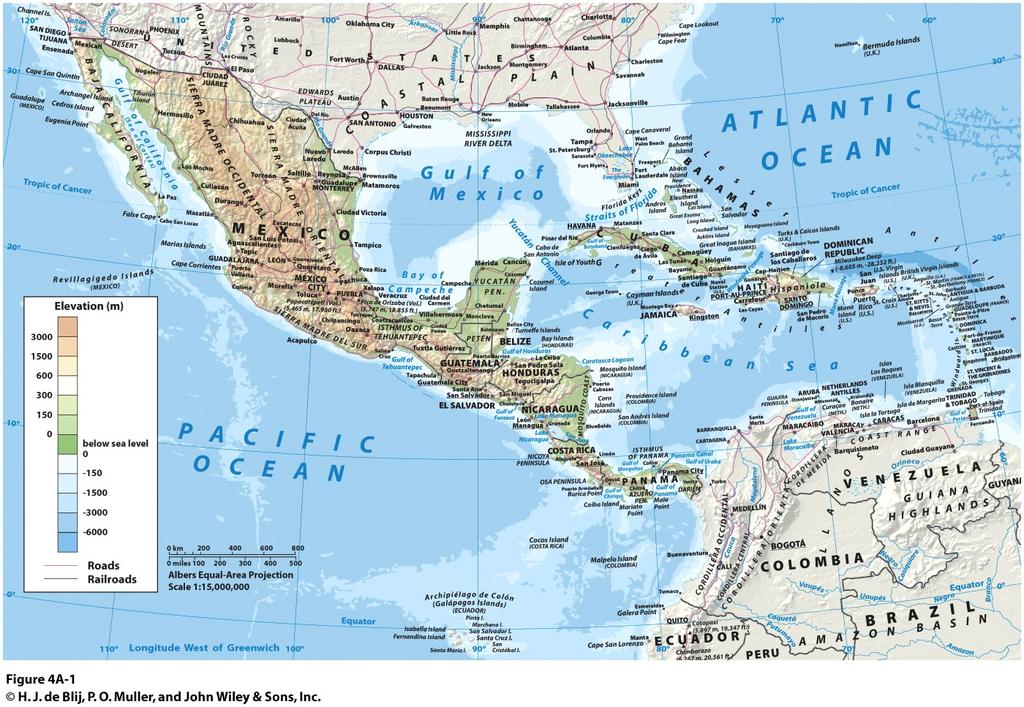
3 Geographical Features: The Realm s Northern Land Boundary Longest land border between realms Cross-border interaction Cross-cultural influence between US & Mexico NAFTA: The North American Free Trade Agreement Change in economic & urban geographies of the border zone Maquiladoras, or assembly factories, are often located as close to the border as possible Brought increased regional inequality & vulnerability to North American economic climate

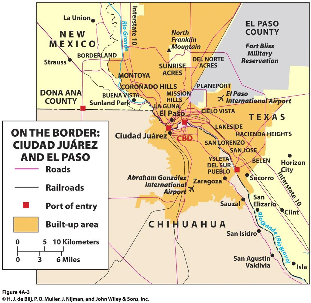
4 Geographical Features: A Troubled Border Zone Main challenges Illegal immigrants pulled by hope for a better life & economic opportunity Drug smuggling & NAFTA Ciudad Juarez & El Paso Both form a single urban area divided by the border New fence construction abandoned Drug smuggling by the impoverished or corrupt Drug violence
5

6 Physical Geography: Panama s Isthmus Narrow 65 km (40 mi) strip of land that bends to an east-west orientation Land bridge that links two continents Crucial role in diffusion of animals & humans across the planet A Land Bridge Concept Caching: Panama Canal
7 Physical Geography: Approximately 7000 islands in the Caribbean A large archipelago or island chain, including: Greater Antilles: the 4 larger islands Lesser Antilles: remaining smaller islands The crests & tops of ocean floor mountain chains that formed out of tectonic plate collisions Island Chains
8 Physical Geography: Dangerous Landscapes Tectonic hazards: Volcanoes & Earthquakes Ex: 2010 Haiti earthquake Extreme weather: Hurricanes Key conditions: warm ocean water that evaporates into rapidly rising moist air Last June to December, with peak in August & September Generated from the west coast of Africa & carried by the Trade Winds Hurricane Alley : the westward pathway across the Caribbean Basin

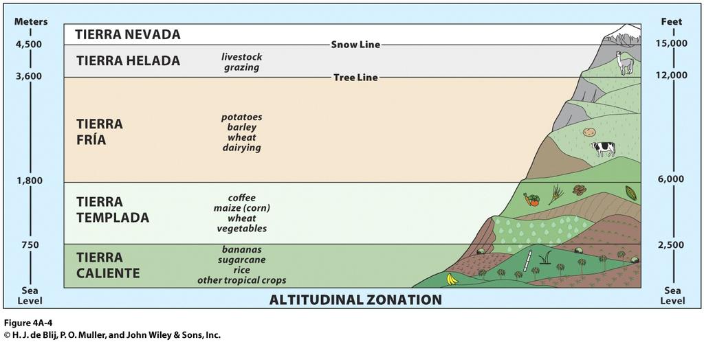
9 Physical Geography: Altitudinal Zonation of Environments High relief environmental regions Zones have distinct climate & physiography Altitudinal zones as vertical elevation regions As elevation increases, climate gets colder
10


11 Map Analysis Activity: Portraying altitudinal zonation 1. What visual coding unites the physical map and the diagram of altitudinal zonation? 2. Use the coding and the diagram s list of crops, identify which areas might be best suited to produce certain crops. Physical Geography

12 Physical Geography: Tropical Deforestation Tropical deforestation Clearing & destruction of forests for settlement & economic opportunity Relates to systemic problems in disadvantaged countries Pasture Logging Subsistence living Concept Caching: Boundary between Haiti and the Dominican Republic Contributes to soil erosion & flooding
13 Cultural Geography: Mesoamerican Legacy Mesoamerican Culture hearth as a source for ideas, population expansion & cultural progress Hearth extended from present-day Mexico City to Nicaragua Unified a large, environmentally diverse area In the low-lying tropical plains & Guatemalan highlands the Maya Civilization arose over 3000 years ago In Central Mexico s high plateau the Aztecs centered on the largest city ever in pre-colombian times

14 Cultural Geography: World s only major culture hearth in a lowland tropics area Civilization of city-states Dynastic rule alongside a religious hierarchy Population of 2 3 million Maya languages still in use Cultural achievements: Agriculture & animal domestication The Lowland Maya Concept Caching: Mayan ruins in Cozumel Island, Mexico Basic industry & trade Intellectual pursuits in art & science

15 Cultural Geography: The Highland Aztecs Intermontane highland zone: the Valley of Mexico Aztec state First true urban center of Western Hemisphere: Teotihuacán Territorial expansion driven by need to extract taxes & tribute from other groups Concept Caching: Pyramid of the Sun at Teotihuacán Cultural achievements: Irrigation & terracing Agricultural domestication of a variety of crops

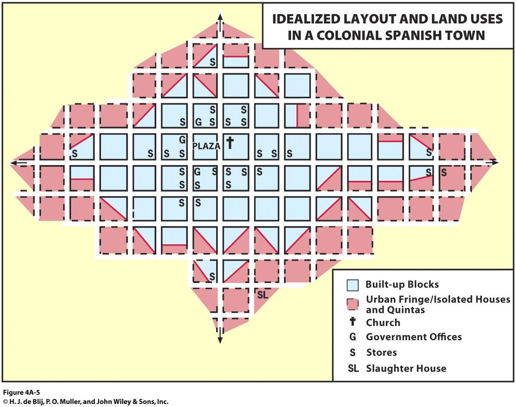
16 Arrival of the Spanish Defeated the Aztecs & enslaved Amerindians Brought disease that wiped out millions Spanish modifications to the landscape: Deforestation Introduction of livestock, new crops & equipment Cultural Geography: Spanish Conquest Spanish settlement style Towns for administration & cultural propagation Town layout around a central plaza with streets in a grid pattern
17

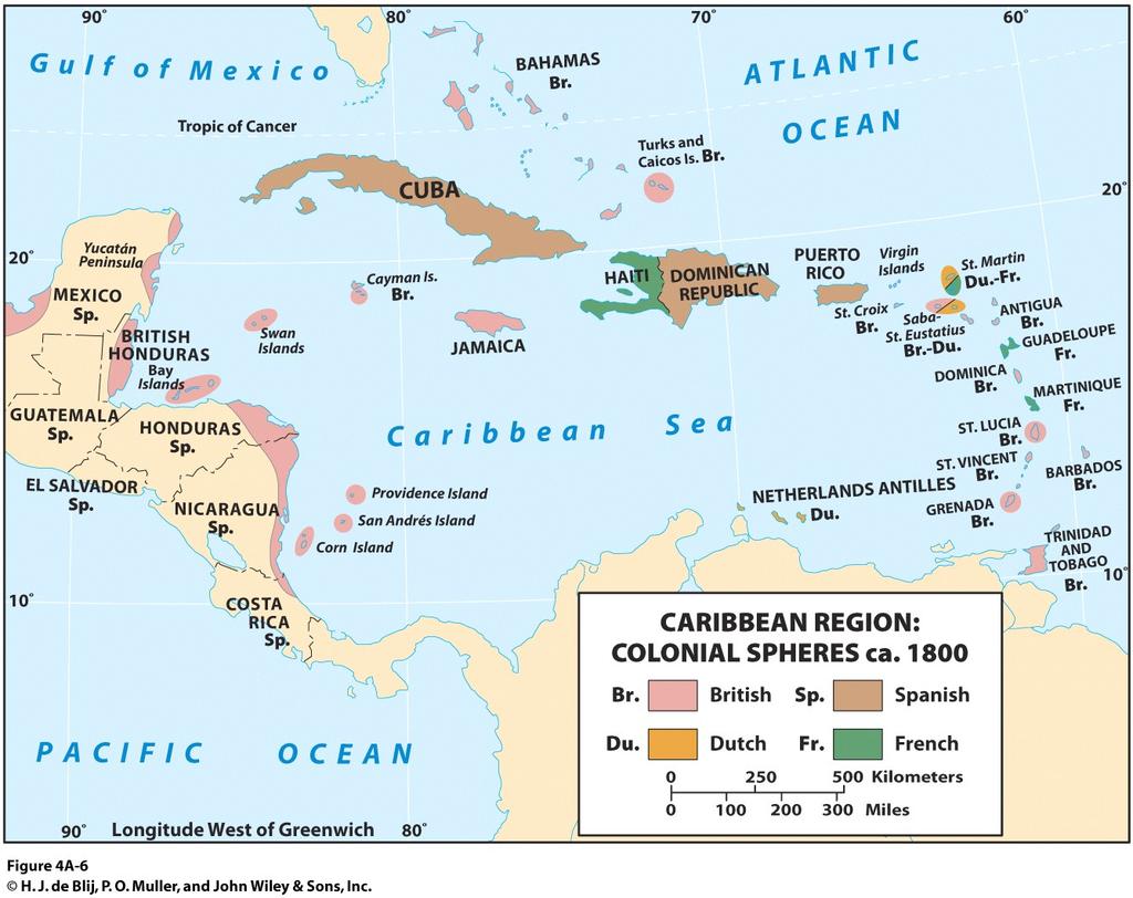
18 European Competition Spain s focus on Panama, Pacific Central America & Mexico British foothold on mainland Caribbean islands were fought over by Spain, Britain, France & the Netherlands Later, American presence on mainland Cultural Geography: Collision of Cultures Culture changed again when Africans were brought in to work on plantations
19
20 Political and Economic Fragmentation: Independence Early 19 th century geopolitics 1820s independence for Mexico & Central America Monroe Doctrine & US Sphere of Influence 1898 Spanish-American War Panama Canal construction US banana plantations in Central America Caribbean Basin Independence Some islands gained independence in 1960s, others later & others not yet

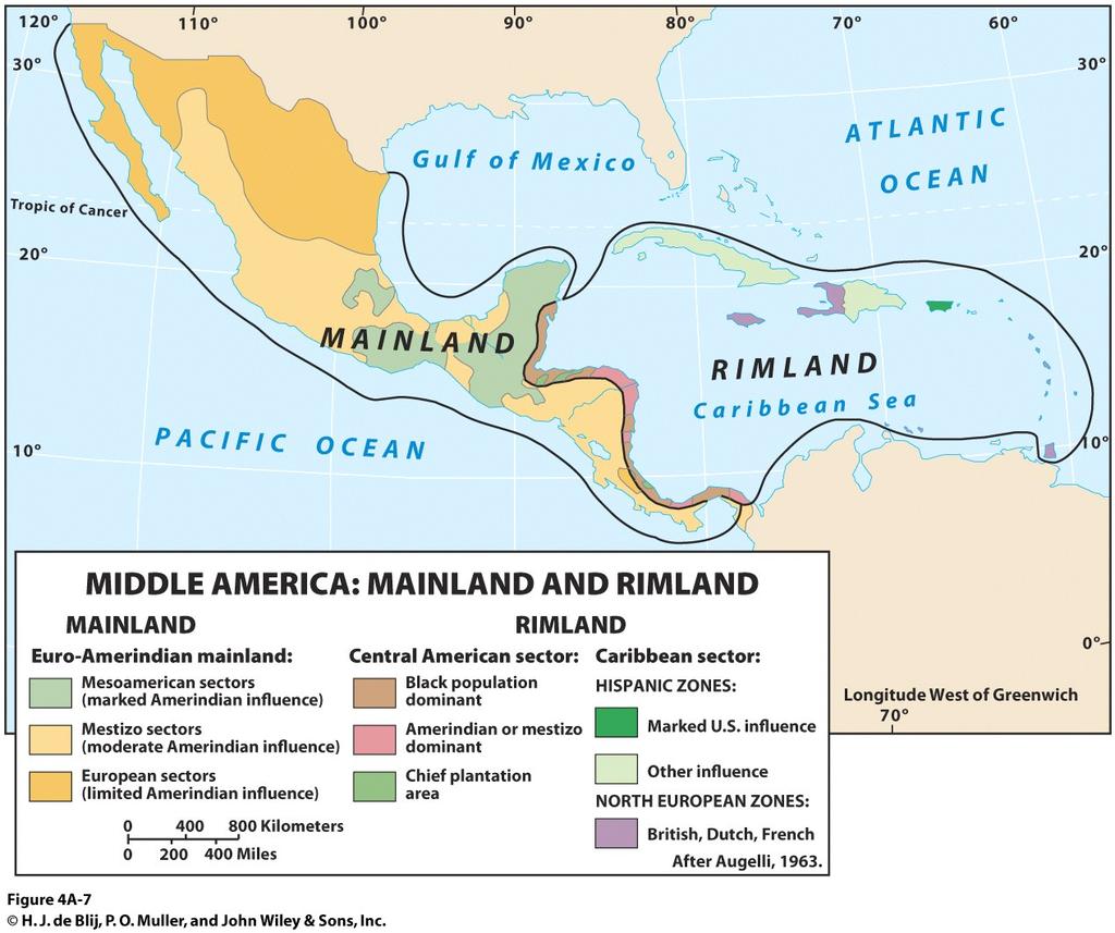
21 Political and Economic Fragmentation: Mainland Euro-Amerindian dominance & mestizo, or mixed ancestry persons Hacienda system & social prestige Rimland Caribbean coast & islands Fusion of European & African influences Plantation land tenure & economy of efficiency Regional Contrasts Mainland-Rimland framework based on the realm s striking social & economic contrasts
22

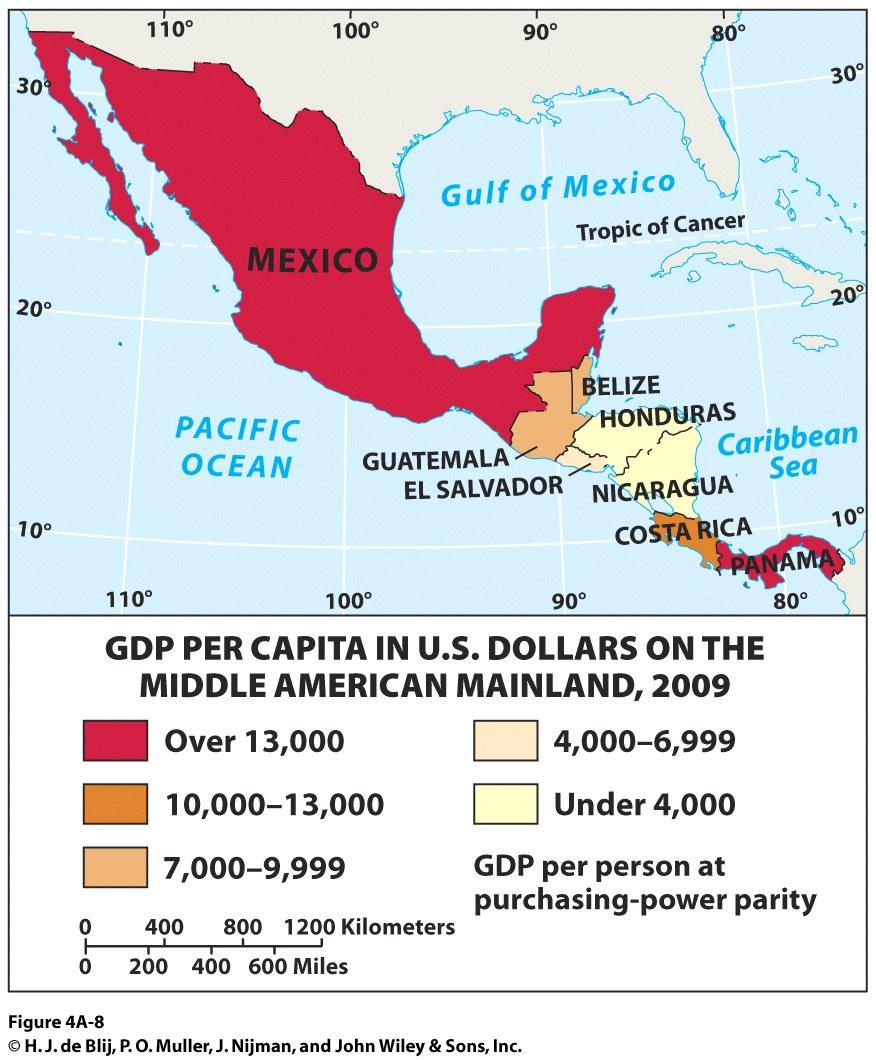
23 Political and Economic Fragmentation: Role of connectivity as the direct links between locations Connections & the correlation to economic development Higher GDP Mexico s connection with the US Panama s global canal Lower GDP Central states of the realm Connections Matter
24
25 Political and Economic Fragmentation: Is Small Beautiful? Realm s considerable number of small countries Both in terms of territorial & population size Challenges of insularity, remoteness & low connectivity Small-island developing economies Disadvantages faced by small island-states Limited natural resources & relying on imports Lack of connectivity results in high transport costs Greater expense for government services per capita Local producers lack competitiveness with cheaper imports; causing unemployment

26 Political and Economic Fragmentation: Tourism industry provides needed income & jobs Caribbean tourism drawbacks: Lifestyle contrasts & local resentment Debasing of local culture as a commodity Monopolizing of revenues by non-local businesses Is Small Beautiful? Concept Caching: Atlantis Resort and Casino Nassau, Bahamas What do you think? Is tourism beneficial or detrimental for Caribbean island-states? Why?
27 Regional Issue The Role of the Tourist Industry in Middle American Economies IN SUPPORT OF THE TOURIST INDUSTRY Without tourism, there is no economy Demand for infrastructure benefits locals too Affluent tourists will always come to escape Northern climates It is a clean industry It is educational CRITICAL OF THE TOURIST INDUSTRY Tourism does not constitute a real & fundamental benefit to local economies Tourism represents inequality & affluent isolation It debases local peoples & cultures to tourists tastes Tourism is still environmentally damaging
28 Political and Economic Fragmentation: The Push for Regional Integration Poor connections among the realm Many rely more on large, outside countries for trade and more Efforts to advance economic integration to foster a functional region CARICOM (Caribbean Community) of 1989 Follows the example of the EU Economic change has been slow
Academic Vocabulary CONTENT BUILDER FOR THE PLC WORLD GEOGRAPHY
 Academic Vocabulary CONTENT BUILDER FOR THE PLC WORLD GEOGRAPHY : academic vocabulary directly taken from the standard STANDARD WG.1A analyze the effects of physical and human geographic patterns and processes
World Geography Fall 2013 Semester Review Project
 Reporting Category RC 1: History, Government and Citizenship Standard WG.1 History. The student understands how geography and processes of spatial exchange (diffusion) influenced events in the past and
Unit 1: Basics of Geography Test Review
 Name Date Period Unit 1: Basics of Geography Test Review Directions: Reading the following sections and complete the questions, charts, and diagrams. Types of Maps Maps that have a particular theme are
9. Besides tourism, what other methods do people in the Caribbean islands use to generate
 9. Besides tourism, what other methods do people in the Caribbean islands use to generate wealth? 10. How do differences in musical styles tell a story of Caribbean culture? G E O G R A P H Y E X E R C
World Geography TEKS 2nd Nine Weeks. Unit of Study Regional Studies; U.S. and Canada Regional Studies; Latin America; and Europe
 World Geography TEKS 2nd Nine Weeks Unit of Study Regional Studies; U.S. and Canada Regional Studies; Latin America; and Europe 1) History. The student understands how geography and processes of spatial
World Geography Mid Term Review 2016
 World Geography Mid Term Review 2016 1.Latitude and Longitude Lines of latitude run and. The zero-degree line is the. Line of longitude run and. The zero degree line is called the. 2. Map Projections What
Amarillo ISD Social Studies Curriculum
 Amarillo Independent School District follows the Texas Essential Knowledge and Skills (TEKS). All of AISD curriculum and documents and resources are aligned to the TEKS. The State of Texas State Board
Chapter 1: The Geography of the Western Hemisphere
 Chapter 1: The Geography of the Western Hemisphere Chapter 1, Lesson 1: The Changing Earth Objectives: - You will be able to identify the major natural events that cause the earth to change. - You will
Oklahoma Academic Standards Science Grade: 6 - Adopted: 2014
 Main Criteria: Oklahoma Academic Standards Secondary Criteria: Subjects: Science, Social Studies Grade: 6 Correlation Options: Show Correlated OK.6-LS. Oklahoma Academic Standards Science Grade: 6 - Adopted:
LOUISIANA STUDENT STANDARDS FOR SOCIAL STUDIES THAT CORRELATE WITH A FIELD TRIP TO DESTREHAN PLANTATION KINDERGARTEN
 LOUISIANA STUDENT STANDARDS FOR SOCIAL STUDIES THAT CORRELATE WITH A FIELD TRIP TO DESTREHAN PLANTATION KINDERGARTEN Standard 2 Historical Thinking Skills Students distinguish between events, people, and
The study of Geography and the use of geographic tools help us view the world in new ways.
 S How does Geography help us understand our world? What factors shape the Earth s different environments? 7.1.9 7.2.9 BIG IDEAS COMPETENCIES Text pages or The study of Geography and the use of geographic
Prentice Hall World Studies, Western Hemisphere 2005 Correlated to: Mississippi Social Studies Frameworks, Western Hemisphere Studies (Grade 6)
") Mississippi Social Studies Frameworks, Western Hemisphere Studies (Grade 6) SIXTH GRADE (Western Hemisphere Studies) STRANDS: (C-Civics); (H-History); (G-Geography); (E-Economics) COMPETENCIES and Suggested
Mississippi Social Studies Frameworks, Western Hemisphere Studies (Grade 6) SIXTH GRADE (Western Hemisphere Studies) STRANDS: (C-Civics); (H-History); (G-Geography); (E-Economics) COMPETENCIES and Suggested
MARS AREA SCHOOL DISTRICT CURRICULUM GRADE: Grade 4
 MARS AREA SCHOOL DISTRICT CURRICULUM GRADE: Grade 4 Course Title: Social Studies Brief Description Overview: Students will explore the history, geography, government, and economy of the United States with
Word Cards. 2 map. 1 geographic representation. a description or portrayal of the Earth or parts of the Earth. a visual representation of an area
 Name: Date: Hour: Word Cards 1 geographic representation a description or portrayal of the Earth or parts of the Earth Example: A map is a representation of an actual location or place. 2 map a visual
Chapter 27. Bhutan, Maldives, Nepal, & Sri Lanka
 Chapter 27 Bhutan, Maldives, Nepal, & Sri Lanka Physical Geography of Bhutan, Maldives, Nepal & Sri Lanka Landforms Their locations on the fringe of South Asia means their physical and human geography
Explain the impact of location, climate, natural resources, and population distribution on Europe. a. Compare how the location, climate, and natural
 SS6G10 Explain the impact of location, climate, natural resources, and population distribution on Europe. a. Compare how the location, climate, and natural resources of Germany, the United Kingdom and
Chapter 27. Bhutan, Maldives, Nepal, & Sri Lanka
 Chapter 27 Bhutan, Maldives, Nepal, & Sri Lanka Physical Geography of Bhutan, Maldives, Nepal & Sri Lanka Landforms Their locations on the fringe of South Asia means their physical and human geography
STAAR Vocabulary Words extracted directly from the standard and/or associated with the instruction of the content within the standard.
 STAAR Vocabulary Words extracted directly from the standard and/or associated with the instruction of the content within the standard. READINESS STANDARDS - World Geography (WG.1) History. The student
Prentice Hall World Studies: Latin America 2005 Correlated to: Missouri Social Studies Grade Level Expectations (Grade 7)
") Principles of Constitutional Democracy 1. Knowledge of the principles expressed in documents shaping constitutional democracy in the United States A. (1) Principles expressed in documents shaping constitutional
Principles of Constitutional Democracy 1. Knowledge of the principles expressed in documents shaping constitutional democracy in the United States A. (1) Principles expressed in documents shaping constitutional
Massachusetts Curriculum Frameworks Science Grade: 4 - Adopted: 2016
 Main Criteria: Massachusetts Curriculum Frameworks Secondary Criteria: Subjects: Science, Social Studies Grade: 4 Correlation Options: Show Correlated Massachusetts Curriculum Frameworks Science Grade:
Map List. 560 World World Physical World Physical-Pacific & Atlantic Region World Landforms World Ocean Floor 10
 Map List CategoryName Map# MapName Thumb nail Page # 560 World 2 561 World Physical 4 562 World Physical-Pacific & Atlantic Region 6 563 World Landforms 8 564 World Ocean Floor 10 565 North Polar Region
This table connects the content provided by Education Perfect to the NSW Syllabus.
 Education Perfect Geography provides teachers with a wide range of quality, engaging and innovative content to drive positive student learning outcomes. Designed by teachers and written by our in-house
Subunit 4.1: 2.5 hours. Subunit 4.2: 2.75 hours. Subunit 4.3: 1.5 hours. Subunit 4.4: 3.5 hours. Subunit 4.5: 1.5 hours Unit 4 Learning Outcomes close
 Unit 4: North America The realm of North America extends from the polar regions of the Arctic in northern Canada and Alaska, all the way south through Mexico and the countries of Central America. Geographers
Grade 7 History Mr. Norton
 Grade 7 History Mr. Norton Section 1: Thinking Geographically Section 2: Land and Climates of the United States Section 3: The Tools of History Section 4: Economics and Other Social Sciences Grade 7 History
5 th Grade Social Studies Goals for the First Trimester Miss Gaull
 5 th Grade Social Studies Goals for the First Trimester Overview: American People, American Land The American People Government by the People Free Enterprise Lands and Regions Resources and the Environment
Sec$on 1: Geography and Early China. How does China s geography affect the culture?
 Sec$on 1: Geography and Early China How does China s geography affect the culture? Con$nents of the World Label the continents. Where is China located? Where is China located? In your groups, begin filling
2 Georgia: Its Heritage and Its Promise
 TERMS region, erosion, fault, elevation, Fall Line, aquifer, marsh, climate, weather, precipitation, drought, tornado, hurricane, wetland, estuary, barrier island, swamp PLACES Appalachian Mountains, Appalachian
Prentice Hall. World Explorer: People, Places, Cultures Grade 7. Oklahoma Priority Academic Student Skills (PASS) for Grade 7 World Geography
 for Grade 7 World Geography") Prentice Hall World Explorer: People, Places, Cultures 2007 Grade 7 C O R R E L A T E D T O for Grade 7 1. Locate, gather, analyze, and apply information from primary and secondary sources. WORLD GEOGRAPHY
Prentice Hall World Explorer: People, Places, Cultures 2007 Grade 7 C O R R E L A T E D T O for Grade 7 1. Locate, gather, analyze, and apply information from primary and secondary sources. WORLD GEOGRAPHY
DESCRIPTION ACADEMIC STANDARDS INSTRUCTIONAL GOALS VOCABULARY. Subject Area: Geography
 DESCRIPTION Middle America is a cultural crossroads. African, Native American, and European influences are seen in its religions, foods, architecture, languages, and arts. Includes discussion of terrains
Scope & Sequence Grade: Four Subject: Social Studies Revised 3/30/ st Quarter (44 Days)
") 1 st Quarter (44 Days) Describe some of the major landforms and waterways in. Describe 4.7 B, 4.9 B, 4.6 A, 4.6 B, 4.22 B, Week 1 Chapter1: The geography of the ways people collect water from the Earth.
1 st Quarter (44 Days) Describe some of the major landforms and waterways in. Describe 4.7 B, 4.9 B, 4.6 A, 4.6 B, 4.22 B, Week 1 Chapter1: The geography of the ways people collect water from the Earth.
I CAN STATEMENTS 6TH GRADE SOCIAL STUDIES
 6TH GRADE SOCIAL STUDIES I can compare historical issues involving rights, roles and statues of individuals. I can describe the relationships among specialization, division of labor, productivity of workers
INDIANA ACADEMIC STANDARDS FOR SOCIAL STUDIES, WORLD GEOGRAPHY. PAGE(S) WHERE TAUGHT (If submission is not a book, cite appropriate location(s))
 WHERE TAUGHT (If submission is not a book, cite appropriate location(s))") Prentice Hall: The Cultural Landscape, An Introduction to Human Geography 2002 Indiana Academic Standards for Social Studies, World Geography (Grades 9-12) STANDARD 1: THE WORLD IN SPATIAL TERMS Students
Prentice Hall: The Cultural Landscape, An Introduction to Human Geography 2002 Indiana Academic Standards for Social Studies, World Geography (Grades 9-12) STANDARD 1: THE WORLD IN SPATIAL TERMS Students
Geography of the Americas
 STATION ACTIVITY Geography of the Americas NAME: Directions: Using each station s text and maps, complete this graphic organizer. Olmec Mayans Aztecs Incas Where was this people group located? (include
Reading for Information Grade 2 Correlations to Idaho Content Standards
 Science Life Science Physical Science Grade 2 Leveled Plants Live and Grow Plants: Alive and Growing Plants: Living and Growing It Takes Force Making Things Move Facts about Force Grade 2 Correlations
Today s Chunks of Learning:
 Geography 11-1-2018 Today s Chunks of Learning: Chunk 1 Patterns of Globalization in Central and South America (continued). Chunk 2 Physical Geography of Sub-Saharan Africa. Chunk 1: These countries have
(version 3) I. HumAN -Environment Interaction
 I. HumAN -Environment Interaction") (version 3) I. HumAN -Environment Interaction A. Landforms 1. Earth s topography is made up of many different types of landforms. 2. While the planet is covered primarily with water, the four major types
(version 3) I. HumAN -Environment Interaction A. Landforms 1. Earth s topography is made up of many different types of landforms. 2. While the planet is covered primarily with water, the four major types
SOCIAL STUDIES GRADE 5. I Can Checklist Office of Teaching and Learning Curriculum Division REGIONS AND PEOPLE OF THE WESTERN HEMISPHERE
 SOCIAL STUDIES REGIONS AND PEOPLE OF THE WESTERN HEMISPHERE GRADE 5 I Can Checklist 2015-2016 Aligned with Ohio s Learning Standards for Social Studies Office of Teaching and Learning Curriculum Division
World Geography. WG.1.1 Explain Earth s grid system and be able to locate places using degrees of latitude and longitude.
 Standard 1: The World in Spatial Terms Students will use maps, globes, atlases, and grid-referenced technologies, such as remote sensing, Geographic Information Systems (GIS), and Global Positioning Systems
GRADE LEVEL: SIXTH SUBJECT: SOCIAL STUDIES DATE: CONTENT STANDARD INDICATORS SKILLS ASSESSMENT VOCABULARY ISTEP
 CRAWFORDSVILLE COMMUNITY SCHOOL CORPORATION GRADE LEVEL: SIXTH SUBJECT: SOCIAL STUDIES DATE: 2016 2017 GRADING PERIOD: QUARTER 3 MASTER COPY 11 28 16 CONTENT STANDARD INDICATORS SKILLS ASSESSMENT VOCABULARY
Global Atmospheric Circulation. Past climate change and natural causes. Global climate change and human activity
 GCSE Geography Edexcel B Revision Checklist Paper 1. Global Geographical Issues Topic 1. Hazardous Earth Key Idea I know/ understand The world s climate system Global Atmospheric Circulation Past climate
Social Studies. Chapter 2 Canada s Physical Landscape
 Social Studies Chapter 2 Canada s Physical Landscape Introduction Canada s geography its landforms and climate - has a great impact on Canadians sense of identity. Planet Earth The earth is divided into
World Geography Review Syllabus
 Purpose Class: World Geography Review Syllabus This course is designed to help students review and remediate their understanding major themes, concepts, and facts connected to the study World Geography.
MASSACHUSETTS HISTORY & SOCIAL SCIENCE LEARNING STANDARDS Grade 6 HISTORY AND GEOGRAPHY
 Massachusetts History and Social Science Curriculum Framework Learning Standards, World Geography (Grade 6) Grade 6 HISTORY AND GEOGRAPHY 1. Use map and globe skills learned in prekindergarten to grade
M14/3/GEOGR/SP2/ENG/TZ0/XX/Q GEOGRAPHY STANDARD LEVEL PAPER 2. Monday 19 May 2014 (morning) 1 hour 20 minutes INSTRUCTIONS TO CANDIDATES
 1 hour 20 minutes INSTRUCTIONS TO CANDIDATES") M14/3/GEOGR/SP2/ENG/TZ0/XX/Q 22145203 GEOGRAPHY STANDARD LEVEL PAPER 2 Monday 19 May 2014 (morning) 1 hour 20 minutes INSTRUCTIONS TO CANDIDATES Do not open this examination paper until instructed to do
M14/3/GEOGR/SP2/ENG/TZ0/XX/Q 22145203 GEOGRAPHY STANDARD LEVEL PAPER 2 Monday 19 May 2014 (morning) 1 hour 20 minutes INSTRUCTIONS TO CANDIDATES Do not open this examination paper until instructed to do
Chapter 11: The Austral Realm
 Geography: Realms, Regions and Concepts 15 th Edition By de Blij and Muller Chapter 11: The Austral Realm Defining the Realm Two countries: Dominant Australia Smaller New Zealand Realm at a crossroads
Wednesday, May 23, 2018
 Wednesday, May 23, 2018 Physical Geography of West Africa Objective: Summarize the main geographic aspects of each country in West Africa. Understand each country s development pattern and their current
New York State Learning Standards and Core Curriculum Science Grade: 5 - Adopted: Matter and Energy in Organisms and Ecosystems
 Main Criteria: New York State Learning Standards and Core Curriculum Secondary Criteria: Subjects: Science, Social Studies Grade: 5 Correlation Options: Show Correlated New York State Learning Standards
Unit 3- Latin America Study Guide Answers
 Unit 3- Latin America Study Guide Answers Multiple Choice Why did many indigenous communities in South America develop as isolated groups? T H E Y W E R E S E P A R A T E D B Y T H E N A T U R A L B A
N05/3/GEOGR/HP2/ENG/TZ0/XX/Q GEOGRAPHY HIGHER LEVEL PAPER 2. Monday 7 November 2005 (morning) 2 hours 30 minutes INSTRUCTIONS TO CANDIDATES
 2 hours 30 minutes INSTRUCTIONS TO CANDIDATES") IB GEOGRAPHY HIGHER LEVEL PAPER 2 DIPLOMA PROGRAMME PROGRAMME DU DIPLÔME DU BI PROGRAMA DEL DIPLOMA DEL BI 88055202 Monday 7 November 2005 (morning) 2 hours 30 minutes INSTRUCTIONS TO CANDIDATES Do not
IB GEOGRAPHY HIGHER LEVEL PAPER 2 DIPLOMA PROGRAMME PROGRAMME DU DIPLÔME DU BI PROGRAMA DEL DIPLOMA DEL BI 88055202 Monday 7 November 2005 (morning) 2 hours 30 minutes INSTRUCTIONS TO CANDIDATES Do not
HOW GEOGRAPHY AND GEOLOGY AFFECT BIOLOGICAL DIVERSITY
 HOW GEOGRAPHY AND GEOLOGY AFFECT BIOLOGICAL DIVERSITY Factors Affecting Extinction Rates Natural Factors Climate change Cataclysmic event (volcano, earthquake) Human Activities Habitat Loss/Fragmentation
Scope & Sequence Grade:4 Subject:Social Studies
 1 st Quarter (43 Days) 1 st : Aug 10-14 2 nd : Aug 17-21 3 rd : Aug 24-28 4 th : Aug 31- Sep 4 5 th : Sept 8-11 6 th : Sept 14-18 7 th : Sept 28- Oct 2 8 th : Oct 5-9 Chapter1: The geography of the Lesson
Geography Route Planner
 Geography Route Planner Introduction to Route Planners Route Planners outline the Key Stages 1-3 curriculum to be taught within each campus of the Bury St Edmunds Trust. Each Route Planner has been designed
August 19 students first day of class (M1-M17) Place. Movement. Human- Environment Interaction. Cartography. Elevation
 Place. Movement. Human- Environment Interaction. Cartography. Elevation") Month August 2010 6 th Grade Western Hemisphere 2010-2011 Curriculum Map Pacing Vocabulary Assessment Resources Content Skills Mapmaster 7. Location August 19 Skills students first Handbook 7.6.1 Region
Month August 2010 6 th Grade Western Hemisphere 2010-2011 Curriculum Map Pacing Vocabulary Assessment Resources Content Skills Mapmaster 7. Location August 19 Skills students first Handbook 7.6.1 Region
Groveport Madison Local School District Sixth Grade Social Studies Content Standards Planning Sheets
 Standard: Citizenship Rights and Responsibilities A. Show the relationship between civic participation and attainment of civic and public goals. 1. Explain how opportunities for citizens to participate
SOCIAL STUDIES Grade 6 Standard: History
 Standard: History Chronology A. Interpret relationships between events shown on multipletier 1. Construct a multiple-tier time line from a list of events time lines. and interpret the relationships between
Campus: VALLEY VIEW HIGH SCHOOL Content Area: Social Studies
 Campus: VALLEY VEW HGH SCHOOL : Map Name: Grading Period: 1 1A 21A 21B 21D 21E 22A 22B 22C 22D 3A 3B Description, TEKS Concept and Description analyze the effects of physical and human ggraphic patterns
I. PRACTICAL GEOGRAPHY A. Maps. B. Scale and measurement. C. Map reading and interpretation; D. Interpretation of statistical data;
 TOPICS/CONTENTS/NOTES OBJECTIVES I. PRACTICAL GEOGRAPHY A. Maps Ai define and identify different types and uses of maps B. Scale and measurement distances, areas reduction and enlargement, directions,
1 st Six Weeks # of Days. Unit # and Title Unit 1 Geography Overview
 1 st Six Weeks # of Days Unit # and Title Unit 1 Geography Overview Orange Grove ISD Instructional Planning Information and Process Standards The Process Standards Must Be Included in Each Unit # of Class
Pacemaker World Geography and Cultures. correlated to. Louisiana Social Studies Grade Level Expectations: World Geography Geography Grades 9-12
 Pacemaker World and Cultures correlated to Louisiana Social Studies Grade Level Expectations: World Grades 9-12 Pacemaker World and Cultures Pearson Learning Group correlated to Louisiana Social Studies
Chapter 32. Australia & New Zealand
 Chapter 32 Australia & New Zealand Lesson 1: Physical Geography of Australia & New Zealand Landforms Australia lies between the Pacific and Indian Oceans in the Southern Hemisphere. Although an island,
Socorro Independent School District World Geography 3 rd 9 Weeks. Culture. Government. European Terminology
 Unit Essential Questions SE Monday Tuesday Wednesday Thursday Friday Unit 05: Latin America Unit 6: How did the major landforms of Latin America impact its developmen t? How is Latin American history a
Geography Test Unit 1 Study Guide. democracy profit citizenship Bill of Rights consumers federal government political process values
 Geography Test Unit 1 Study Guide Skills Identify Longitude and Latitude Identify Continents of the World Identify Time Zones Equator Prime Meridian Hemispheres Map Requirements Oceans Compare US/Mexico/Canada
Reading for Information Grade 2 Correlations to New Mexico Content Standards
 Grade 2 Correlations to New Mexico Content Standards Science Earth Science Health Grade 2 Leveled Plants Live and Grow Plants: Alive and Growing Plants: Living and Growing All about Soil What Is Soil?
The Age of Exploration & First Contact. Unit 9
 The Age of Exploration & First Contact Unit 9 Unit 9 Table of Contents The Age of Exploration and First Contact 190. Unit 9 Table of Contents 191. Cover Page Unit 9 (use Chapter 12) Bellwork Set up and
Brazil The country of Brazil is used to consider the different climatic conditions that can occur and why that is. Sport
 SUBJECT : Geography 2014 15 Yr7 What is geography? Students are introduced to the topic of geography and why it is so important to our everyday lives. Within the subject students explore the differences
Content Area: Social Studies Standard: 1. History Prepared Graduates: Develop an understanding of how people view, construct, and interpret history
 Standard: 1. History Develop an understanding of how people view, construct, and interpret history 1. Organize and sequence events to understand the concepts of chronology and cause and effect in the history
SUBJECT : Geography Topics: Learning Outcomes:
 SUBJECT : Geography 2016-17 Yr7 What is geography and Britain? Students are introduced to the topic of geography and why it is so important to our everyday lives. Within the subject students explore the
Edexcel GCSE Geography A
 Edexcel GCSE Comparing the 2012 AQA GCSE specification with the new 2016 Edexcel specification This document is designed to help you compare the existing 2012 AQA GCSE specification (9030) with the new
Physical Geography of East Asia
 Physical Geography of East Asia Satellite View of China Landforms of China China s Geography China Miles 0 250 500 1,000 1,500 2,000 United States 3 rd largest country in the world. Comparable to the US
Social Studies World Geography Unit 01: Physical Geography
 Social Studies World Geography Unit 01: Physical 012 2013 1 Tectonic plate movement may be caused by all of the following EXCEPT A slab pull B ridge push C convection D magnetism 2 An earthquake is part
Terrain Units PALEOGEOGRAPHY: LANDFORM CREATION. Present Geology of NYS. Detailed Geologic Map of NYS
 NYS TOPOGRAPHY Why so? PALEOGEOGRAPHY: LANDFORM CREATION Prof. Anthony Grande AFG 014 Present Geology of NYS Detailed Geologic Map of NYS Generalized Geology Detailed Geology Hot links to the fold out
September 14, 2013 Objective: How does geography impact history? What important features exist that have shaped societies?
 Lowenhaupt 1 September 14, 2013 Objective: How does geography impact history? What important features exist that have shaped societies? Warm-Up: In your binder, answer the following question: Imagine you
Your web browser (Safari 7) is out of date. For more security, comfort and the best experience on this site: Update your browser Ignore
 is out of date. For more security, comfort and the best experience on this site: Update your browser Ignore") Your web browser (Safari 7) is out of date. For more security, comfort and the best experience on this site: Update your browser Ignore ISTHMU S tombolo For the complete encyclopedic entry with media resources,
Your web browser (Safari 7) is out of date. For more security, comfort and the best experience on this site: Update your browser Ignore ISTHMU S tombolo For the complete encyclopedic entry with media resources,
The structure of the Earth and how its motion creates the seasons. The landforms of the earth and the forces that shape the land.
 The structure of the Earth and how its motion creates the seasons. The landforms of the earth and the forces that shape the land. The role of wind and water in creating climate. The different climate and
Five Themes of Geography Project Ms. Kiesel, Per 5. The United States of America
 Five Themes of Geography Project Ms. Kiesel, Per 5 The United States of America Location Absolute Location : The USA is located in the continent of North America in the northern and western hemispheres.
6/25/2018. Upcoming Classes After Today. Our Only Presentation Day: Monday, July 2
 Upcoming Classes After Today Tuesday (June 26): Pacific Northwest and the Northlands Wednesday (June 27): Geographic Literacy in America; Take-Home Midterm Exam #2 distributed and discussed Thursday (June
Geography Long Term Plan 2018
 Geography Long Term Plan 2018 Geography Co-ordinator: Megan Frost A high-quality geography education should inspire in pupils a curiosity and fascination about the world and its people that will remain
Peoples, Places and Cultures in Africa, Asia and the Southwest Pacific
 GRADE 7 Peoples, Places and Cultures in Africa, Asia and the Southwest Pacific Course 0470-07 Students in seventh grade explore the history, geography, government, economic systems, current issues, and
Eastern Hemisphere Geography 7th Grade *Chapters 1-10 covered in 6 th Grade
 Quarter 1 Geography Tools and Concepts Chapters 1-5 Intro to Geography = 2 day review Goal Objective Task Analysis Vocabulary Text Location Goal 2.1: Analyze the 6-9.GEH.2.1.1 Explain and use the Identify
Grade 5: Social Studies Practices
 Grade 5: Social Studies Practices A. Gathering and Using Evidence 1. Develop questions to help identify evidence about topics related to the historical events occurring in the Western Hemisphere that can
11/14/2017. Key City Focus: Phoenix
 Semester Project Reminder Semester Project presentations begin on Monday, November 20 (and continue on Monday, November 27 and Wednesday, November 27). See the presentation schedule posted online for your
KS1. Geography Progression of Knowledge, Understanding and Skills WIJPS
 Geography Progression of Knowledge, Understanding and Skills WIJPS Geography inspires pupils to delve deeper and with more curiosity and fascination into the world around them and its people. The knowledge
Physical Geography: Patterns, Processes, and Interactions, Grade 11, University/College Expectations
 Geographic Foundations: Space and Systems SSV.01 explain major theories of the origin and internal structure of the earth; Page 1 SSV.02 demonstrate an understanding of the principal features of the earth
Warmup. geography compass rose culture longitude
 Warmup geography compass rose culture longitude ecosystem latitude 1. study of the special physical and human characteristics of a place or region 2. learned system of shared beliefs, traits, and values
Landforms in Canada. Canada is made up of three dis;nct types of landforms: Canadian Shield Highlands Lowlands
 Canada s Landforms What is a Landform? A landform is any physical feature of the Earth s surface having a characteris;c, recognizable shape, produced by natural causes. Landforms include major features
Socials Studies. Chapter 3 Canada s People 3.0-Human Geography
 Socials Studies Chapter 3 Canada s People 3.0-Human Geography Physical Geography Study of the natural features of the Earth s surface including landforms, climate, ocean currents and flora and fauna Human
South Carolina Standards & Learning Science Grade: 3 - Adopted: 2014
 Main Criteria: South Carolina Standards & Learning Secondary Criteria: Subjects: Science, Social Studies Grade: 3 Correlation Options: Show Correlated South Carolina Standards & Learning Science Grade:
Compare and contrast strengths & weaknesses of globes and maps. Difference between physical and political maps
 Curricu um: Chambersburg Area SD Curriculum PENNSYLVANIA Course: Western Hemisphere - 6 Date: August 29, 2011 ET pic: A: Geography SkiNs Days: 20 Know: Understand: Do: Geographic Concept One - Five representations
WORLD GEOGRAPHY PLANNER Grade 7
 Standard : Civics-Government Benchmark : Rule of law SS7-... (K) understands the difference between criminal and civil law as i applies to individual citizens (e.g., criminal: felony, misdemeanor, crimes
MEADOWS PRIMARY SCHOOL and NURSERY GEOGRAPHY POLICY
 MEADOWS PRIMARY SCHOOL and NURSERY GEOGRAPHY POLICY Purpose of study The teaching of Geography at Meadows is done by following the 2014 National Curriculum. The planning and teaching of the subject aims
Coimisiún na Scrúduithe Stáit State Examinations Commission
 M. 24 Coimisiún na Scrúduithe Stáit State Examinations Commission LEAVING CERTIFICATE EXAMINATION 2004 GEOGRAPHY HIGHER LEVEL MONDAY, 14 JUNE, AFTERNOON 1.30 TO 4.50 Four questions to be answered, namely
Chapter 2 - Lessons 1 & 2 Studying Geography, Economics
 Chapter 2 - Lessons 1 & 2 Studying Geography, Economics How does geography influence the way people live? Why do people trade? Why do people form governments? Lesson 1 - How Does Geography Influence the
AP Human Geography Unit 7a: Services Guided Reading Mr. Stepek Introduction (Rubenstein p ) 1. What is the tertiary sector of the economy?
 1. What is the tertiary sector of the economy?") Public Business Consumer AP Human Geography Unit 7a: Services Guided Reading Mr. Stepek Introduction (Rubenstein p 372 374) 1. What is the tertiary sector of the economy? 2. What is a service activity?
Public Business Consumer AP Human Geography Unit 7a: Services Guided Reading Mr. Stepek Introduction (Rubenstein p 372 374) 1. What is the tertiary sector of the economy? 2. What is a service activity?
Social Studies: The World Post Test Study Guide
 Name: Period: Social Studies: The World Post Test Study Guide Map and Globe Skills: Label the continents and oceans on the lines below the map. 1 11 3 4 5 8 2 9 10 8 6 7 1. 8. 2. 9. 3. 10. 4. 11. 5. 6.
Chapter 32. Australia & New Zealand
 Chapter 32 Australia & New Zealand Lesson 1: Physical Geography of Australia & New Zealand Landforms Australia lies between the Pacific and Indian Oceans in the Southern Hemisphere. Although an island,
Of topic specific knowledge and understanding To encourage progressive development in 'thinking geographically'
 [August 2012] Content exemplars 1. Broad description of the content: Single paragraph, written with technical precision Content rigour (avoiding generic statements) Identifying the core of essential knowledge
Geography. Programmes of study for Key Stages 1-3
 Geography Programmes of study for Key Stages 1-3 February 2013 Contents Purpose of study 3 Aims 3 Attainment targets 3 Subject content 4 Key Stage 1 4 Key Stage 2 5 Key Stage 3 6 2 Purpose of study A high-quality
Social Studies Continuum
 Historical Skills chronological thinking understand that we can learn about the past from different sorts of evidence begin to use historical resources apply research skills by investigating a topic in
Social Studies (4) Social Science
 Social Science") Scope And Sequence Timeframe Unit Instructional Topics 8 Day(s) Course Overview Students will learn about the regions of the United States with emphasis on local and state history, geography, government,
Scope And Sequence Timeframe Unit Instructional Topics 8 Day(s) Course Overview Students will learn about the regions of the United States with emphasis on local and state history, geography, government,
Physical Geography of the United States and Canada Chapter 5 A Land of Contrasts
 Physical Geography of the United States and Canada Chapter 5 A Land of Contrasts Land Area Together the U.S. and Canada cover more than 7 million square miles. In total area, Canada ranks 2 nd and the