WHO lunchtime seminar Mapping child growth failure in Africa between 2000 and Professor Simon I. Hay March 12, 2018
|
|
|
- Kelley Chase
- 5 years ago
- Views:
Transcription

1 WHO lunchtime seminar Mapping child growth failure in Africa between 2000 and 2015 Professor Simon I. Hay March 12, 2018
2 Outline Local Burden of Disease (LBD) at IHME Child growth failure From global to local o Data o Model o Results Implications and impact Limitations Future directions
3 Outline Local Burden of Disease (LBD) at IHME Child growth failure From global to local o Data o Model o Results Implications and impact Limitations Future directions


4 Prevalence of stunting (%) Precision public health: a new approach National (or even subnational) averages can hide important local health variation The use of data to guide interventions that benefit populations more efficiently and increase equity in outcomes National Admin 1 Admin 2 5x5 km
5 Prevalence of stunting (%) Local Burden of Disease project goals Assemble the world s largest geopositioned dataset on key diseases and risk factors Create high-resolution (5x5 km) maps of prevalence, incidence, or mortality Create compelling and useful interactive data visualization tools to illuminate levels, trends, and disparities over time Disseminate results and encourage uptake by donors, policymakers, and researchers to inform evidence-based decision-making

6 Location Burden of Disease team 50+ team members o Data Analysts o Data Extraction Analysts o Data Mapping Specialist o Data Services Specialist o o o o o Director Engagement Officer Faculty Fellows PhD Student o o o o Policy Translation Specialist Project Officers Research Coordinator Research Managers o o o Researchers Senior Research Manager Software Engineers
7 What we are mapping Malaria (P.f. and P.v.) Diarrhea Lower respiratory infections (LRI) Tuberculosis HIV/AIDS Under 5 mortality Educational attainment Child growth and nutrition o o o o Stunting, wasting, underweight Low birth weight Child overweight Exclusive breastfeeding NTD: lymphatic filariasis, onchocerciasis, and schistosomiasis Water and sanitation Vaccine coverage (DTP3, measles, etc.). Ebola and other hemorrhagic fevers Pandemic potential of five emerging zoonotic infectious diseases AMR: 17 bacteria-antibacterial drug combinations
8 Outline Local Burden of Disease (LBD) at IHME Child growth failure From global to local o Data o Model o Results Implications and impact Limitations Future directions
9 Child growth failure Stunting Height-for-age z-score <-2 SD Wasting Weight-for-height z-score <-2 SD Underweight Weight-for-age z-score <-2 SD Specific subset of child undernutrition, excluding micronutrient deficiencies Relationship between insufficient height and weight at a given age Described in terms of univariate growth standards by WHO, where agespecific height and weight are compared to healthy reference populations
10 Future directions Policy relevant analysis WHO Global Targets 2025 to improve young child nutrition Sustainable Development Goal 2.2 to end all forms of malnutrition by 2030, including achievement of the Global Targets 2025
11 Outline Local Burden of Disease (LBD) at IHME Child growth and nutrition From global to local o Data o Model o Results Implications and impact Limitations Future directions

12 Geospatial data Point o GPS coordinates (latitude/longitude) o Infinitesimal representation Polygon o Aerial representation (mean over a region) o Typically data matched to shape files Raster o o Data discretized over continuous space, represented by pixel values in a bitmap Covariates and outputs
13 Data coverage


14 Sparse data Some areas have robust data coverage, and we can make confident predictions Others have more sparse coverage, so our predictions are less certain
15 How do we generate predictions in areas with sparse data? 256 geo-located datasets Household surveys A suite of geospatial covariates Satellite imagery and modeled surfaces of relevant environmental and human activity
16 DATA COVARIATES ENSEMBLE OF MACHINE LEARNING MODELS Maximize the predictive power of the covariates
17 MODEL-BASED GEOSTATISTICS Borrow strength from observations nearby in space and time, accounting for leftover variation

18 CALIBRATION TO GBD Leverage validated Global Burden of Disease (GBD) estimates which utilize additional data sources RESULTS Pixel-level estimates with uncertainty intervals, extremely flexible with many use cases

19 Results 2015, under 5 stunting prevalence National Admin 1 Admin 2 5x5 km
20 Results 2000, under 5 stunting prevalence
21 Results 2005, under 5 stunting prevalence
22 Results 2010, under 5 stunting prevalence
23 Results 2015, under 5 stunting prevalence
24 Results , Overlapping populationweighted lowest and highest 10% of pixels and annualised rates of change (AROC) in stunting prevalence


25 Results Annualized decrease in stunting prevalence from relative to rates needed during to meet the WHO GNT Regressing On track Exceeding

26 Results 2025, Predicted stunting prevalence based on annualised decrease achieved between 2000 and 2015
27 Results , Acceleration in the annualized decrease in stunting required to meet the WHO GNT by 2025 Met goal by 2015 On track 2x rate of progress needed 4x rate of progress needed

28 Results 2015, Probability that the Global Nutrition Target for stunting has been achieved at the first administrate subdivision and 5x5 km pixel level


29 Results 2015, under 5 wasting prevalence National Admin 1 Admin 2 5x5 km

30 Results 2000, under 5 wasting prevalence
31 Results 2005, under 5 wasting prevalence
32 Results 2010, under 5 wasting prevalence
33 Results 2015, under 5 wasting prevalence

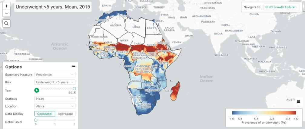
34 Results 2015, under 5 underweight prevalence National Admin 1 Admin 2 5x5 km
35 Results 2000, under 5 underweight prevalence
36 Results 2005, under 5 underweight prevalence
37 Results 2010, under 5 underweight prevalence
38 Results 2015, under 5 underweight prevalence
39 Outline Local Burden of Disease (LBD) at IHME Child growth and nutrition From global to local o Data o Model o Results Implications and impact Limitations Future directions

40 Implications and impact: publishing
41 Implications and impact: precision public health

42 Implications and impact: in the media

43 Implications and impact: how can decision-makers use the research?

44 Interactive data visualization tool Explore further at
45 Outline Local Burden of Disease (LBD) at IHME Child growth and nutrition From global to local o Data o Model o Results Implications and impact Limitations Future directions

46 Limitations Data coverage and quality o Of 256 data sources, only 127 contain GPS coordinates o Areas of greatest uncertainty correspond to those in need of more/recent information Prediction, not inference o Optimize for prediction, cannot perform correlation inference i.e. relationships between covariates and outcomes Uncertainty propagation o Uncertainty in covariates and population estimates not incorporated
47 Outline Local Burden of Disease (LBD) at IHME Child growth and nutrition From global to local o Data o Model o Results Implications and impact Limitations Future directions

48 Future directions: expanding geographic scope Stage >99% CGF attributable DALYS

49 Future directions: additional Global Targets 2025
 o Diarrhea (Africa) o Water and sanitation (Africa) o Lower respiratory infections (LRI) (Africa) o Under 5 mortality")
50 Future directions Further exploring geographic inequalities Recent or forthcoming publications o Educational attainment (Africa) o Diarrhea (Africa) o Water and sanitation (Africa) o Lower respiratory infections (LRI) (Africa) o Under 5 mortality (Global)
51 Thank you!
52 Additional slides on methods 5
53 Model-based geostatistics Model Assume data arises from underlying random process following a known distribution Bayesian hierarchical model Use a generalized linear model framework, which allows us to incorporate covariates (X i ) in our model logit(p i ) = α + X i β + Z i Z GP 0, C 5
 and internal (i.e. model outputs) covariates available, in a standardized format 5")
54 Model-based geostatistics Covariates Geospatial team is home to a continually growing spatial covariate repository Both external (e.g. satellite data) and internal (i.e. model outputs) covariates available, in a standardized format 5


55 Value of interest Model-based geostatistics 1-D example X 1 X 2 X 3 1D index of space 5
56 Value of interest Model-based geostatistics 1-D example α + X i β + Z i X 1 X 2 X 3 1D index of space 5
57 Value of interest Model-based geostatistics 1-D example α + X i β + Z i X 1 X 2 X 3 1D index of space 5
58 Residual Model-based geostatistics 1-D example α + X i β + Z i X 1 X 2 X 3 1D index of space 5
59 Residual Model-based geostatistics 1-D example α + X i β + Z i X 1 X 2 X 3 1D index of space 5
60 Value of interest Model-based geostatistics 1-D example α + X i β + Z i X 1 X 2 X 3 1D index of space 6
DATA DISAGGREGATION BY GEOGRAPHIC
 PROGRAM CYCLE ADS 201 Additional Help DATA DISAGGREGATION BY GEOGRAPHIC LOCATION Introduction This document provides supplemental guidance to ADS 201.3.5.7.G Indicator Disaggregation, and discusses concepts
An Introduction to Tuberculosis Disease Modeling
 An Introduction to Tuberculosis Disease Modeling Bradley G. Wagner, PhD Institute for Disease Modeling Seminar of Global TB/HIV Research August 3 rd 2018 1 Copyright 2015 Intellectual Ventures Management,
THE ROLE OF GEOSPATIAL AT THE WORLD BANK
 THE ROLE OF GEOSPATIAL AT THE WORLD BANK INSPIRE Conference Barcelona, Spain September 26, 2016 Kathrine Kelm Senior Land Administration Specialist Global Land and Geospatial Unit The World Bank Group
DHS SPATIAL ANALYSIS REPORTS 14
 GUIDANCE FOR USE OF THE DHS PROGRAM MODELED MAP SURFACES DHS SPATIAL ANALYSIS REPORTS 14 AUGUST 2016 This publication was produced for review by the United States Agency for International Development (USAID).
1. Omit Human and Physical Geography electives (6 credits) 2. Add GEOG 677:Internet GIS (3 credits) 3. Add 3 credits to GEOG 797: Final Project
 2. Add GEOG 677:Internet GIS (3 credits) 3. Add 3 credits to GEOG 797: Final Project") The Department of Geography and the Office of Professional Studies propose to modify the Master of Professional Studies in Geospatial Information Sciences (GIS) as follows: 1. Omit Human and Physical Geography
The Department of Geography and the Office of Professional Studies propose to modify the Master of Professional Studies in Geospatial Information Sciences (GIS) as follows: 1. Omit Human and Physical Geography
Additional file A8: Describing uncertainty in predicted PfPR 2-10, PfEIR and PfR c
 Additional file A8: Describing uncertainty in predicted PfPR 2-10, PfEIR and PfR c A central motivation in our choice of model-based geostatistics (MBG) as an appropriate framework for mapping malaria
THE DATA REVOLUTION HAS BEGUN On the front lines with geospatial data and tools
 THE DATA REVOLUTION HAS BEGUN On the front lines with geospatial data and tools Slidedoc of presentation for MEASURE Evaluation End of Project Meeting Washington DC May 22, 2014 John Spencer Geospatial
Disaster Management & Recovery Framework: The Surveyors Response
 Disaster Management & Recovery Framework: The Surveyors Response Greg Scott Inter-Regional Advisor Global Geospatial Information Management United Nations Statistics Division Department of Economic and
Applying Health Outcome Data to Improve Health Equity
 Applying Health Outcome Data to Improve Health Equity Devon Williford, MPH, Health GIS Specialist Lorraine Dixon-Jones, Policy Analyst CDPHE Health Equity and Environmental Justice Collaborative Mile High
Nutrition Stakeholder Mapping in Ethiopia. Federal Ministry of Health / REACH
 Nutrition Stakeholder Mapping in Ethiopia Federal Ministry of Health / REACH NNP Costing exercise Method Examined for costing NNP were MBB; One health and Activity based tool The recommended was activity-based
JOINT STRATEGIC NEEDS ASSESSMENT (JSNA) Key findings from the Leicestershire JSNA and Charnwood summary
 Key findings from the Leicestershire JSNA and Charnwood summary") JOINT STRATEGIC NEEDS ASSESSMENT (JSNA) Key findings from the Leicestershire JSNA and Charnwood summary 1 What is a JSNA? Joint Strategic Needs Assessment (JSNA) identifies the big picture in terms of
JOINT STRATEGIC NEEDS ASSESSMENT (JSNA) Key findings from the Leicestershire JSNA and Charnwood summary 1 What is a JSNA? Joint Strategic Needs Assessment (JSNA) identifies the big picture in terms of
Cluster Analysis using SaTScan
 Cluster Analysis using SaTScan Summary 1. Statistical methods for spatial epidemiology 2. Cluster Detection What is a cluster? Few issues 3. Spatial and spatio-temporal Scan Statistic Methods Probability
Role of GIS in Tracking and Controlling Spread of Disease
 Role of GIS in Tracking and Controlling Spread of Disease For Dr. Baqer Al-Ramadan By Syed Imran Quadri CRP 514: Introduction to GIS Introduction Problem Statement Objectives Methodology of Study Literature
EMMA : ECDC Mapping and Multilayer Analysis A GIS enterprise solution to EU agency. Sharing experience and learning from the others
 EMMA : ECDC Mapping and Multilayer Analysis A GIS enterprise solution to EU agency. Sharing experience and learning from the others Lorenzo De Simone, GIS Expert/ EMMA Project Manager 2014 GIS Workshop,
Maps & Surveys Malawi
 Maps & Surveys Malawi If searched for the ebook Maps & Surveys Malawi in pdf format, in that case you come on to the right site. We furnish the complete release of this ebook in DjVu, epub, doc, txt, PDF
Data Integration Model for Air Quality: A Hierarchical Approach to the Global Estimation of Exposures to Ambient Air Pollution
 Data Integration Model for Air Quality: A Hierarchical Approach to the Global Estimation of Exposures to Ambient Air Pollution Matthew Thomas 9 th January 07 / 0 OUTLINE Introduction Previous methods for
Globally Estimating the Population Characteristics of Small Geographic Areas. Tom Fitzwater
 Globally Estimating the Population Characteristics of Small Geographic Areas Tom Fitzwater U.S. Census Bureau Population Division What we know 2 Where do people live? Difficult to measure and quantify.
Foundation Geospatial Information to serve National and Global Priorities
 Foundation Geospatial Information to serve National and Global Priorities Greg Scott Inter-Regional Advisor Global Geospatial Information Management United Nations Statistics Division UN-GGIM: A global
Purpose Study conducted to determine the needs of the health care workforce related to GIS use, incorporation and training.
 GIS and Health Care: Educational Needs Assessment Cindy Gotz, MPH, CHES Janice Frates, Ph.D. Suzanne Wechsler, Ph.D. Departments of Health Care Administration & Geography California State University Long
Poverty and Hazard Linkages
 Poverty and Hazard Linkages Global Risk Identification Programme Proposal Development Coordination Meeting Friday, 19 May 2006 CIESIN Earth Institute Columbia University www.ciesin.columbia.edu Data Improvements
Presented to Sub-regional workshop on integration of administrative data, big data and geospatial information for the compilation of SDG indicators
 Presented to Sub-regional workshop on integration of administrative data, big data and geospatial information for the compilation of SDG indicators 23-25 April,2018 Addis Ababa, Ethiopia By: Deogratius
Targeting the Poor. Towards evidence-based implementation. Johan A. Mistiaen (World Bank)
") Targeting the Poor Towards evidence-based implementation Johan A. Mistiaen (World Bank) Presentation at Joint Poverty Assessment Workshop Nairobi - May 19, 2005 Outline Integrating Data Sources - GIS What
Targeting the Poor Towards evidence-based implementation Johan A. Mistiaen (World Bank) Presentation at Joint Poverty Assessment Workshop Nairobi - May 19, 2005 Outline Integrating Data Sources - GIS What
Brazil Paper for the. Second Preparatory Meeting of the Proposed United Nations Committee of Experts on Global Geographic Information Management
 Brazil Paper for the Second Preparatory Meeting of the Proposed United Nations Committee of Experts on Global Geographic Information Management on Data Integration Introduction The quick development of
Outline. Introduction to SpaceStat and ESTDA. ESTDA & SpaceStat. Learning Objectives. Space-Time Intelligence System. Space-Time Intelligence System
 Outline I Data Preparation Introduction to SpaceStat and ESTDA II Introduction to ESTDA and SpaceStat III Introduction to time-dynamic regression ESTDA ESTDA & SpaceStat Learning Objectives Activities
Methodology for estimating regional and global trends of child malnutrition
 IJE vol.33 no.6 International Epidemiological Association 2004; all rights reserved. International Journal of Epidemiology 2004;33:1260 1270 Advance Access publication 12 November 2004 doi:10.1093/ije/dyh202
PUBLIC HEALTH ASSOCIATION OF AUSTRALIA Strategic Plan
 PUBLIC HEALTH ASSOCIATION OF AUSTRALIA Strategic Plan March 2017 20 Napier Close Deakin ACT Australia 2600 PO Box 319 Curtin ACT Australia 2605 Table of Contents Introduction... 2 Vision for a healthy
Creating a Staff Development Plan with Esri
 Creating a Staff Development Plan with Esri Michael Green David Schneider Guest Presenter: Shane Feirer, University of California Esri UC 2014 Technical Workshop Agenda What is a Staff Development Plan?
Long Island Breast Cancer Study and the GIS-H (Health)
") Long Island Breast Cancer Study and the GIS-H (Health) Edward J. Trapido, Sc.D. Associate Director Epidemiology and Genetics Research Program, DCCPS/NCI COMPREHENSIVE APPROACHES TO CANCER CONTROL September,
Long Island Breast Cancer Study and the GIS-H (Health) Edward J. Trapido, Sc.D. Associate Director Epidemiology and Genetics Research Program, DCCPS/NCI COMPREHENSIVE APPROACHES TO CANCER CONTROL September,
OC Enterprise GIS. Kevin Hills, PLS Cameron Smith, GISP. OC Survey
 OC Enterprise GIS Kevin Hills, PLS Cameron Smith, GISP OC Survey Discussion Points Background & Organizational Structure of OCPW Past practices prior to Enterprise Wide GIS License (ELA) Participating
Data Aggregation with InfraWorks and ArcGIS for Visualization, Analysis, and Planning
 Data Aggregation with InfraWorks and ArcGIS for Visualization, Analysis, and Planning Stephen Brockwell President, Brockwell IT Consulting, Inc. Join the conversation #AU2017 KEYWORD Class Summary Silos
GIS Spatial Statistics for Public Opinion Survey Response Rates
 GIS Spatial Statistics for Public Opinion Survey Response Rates July 22, 2015 Timothy Michalowski Senior Statistical GIS Analyst Abt SRBI - New York, NY t.michalowski@srbi.com www.srbi.com Introduction
David Rogers Health and Climate Foundation
 David Rogers Health and Climate Foundation Using environmental information Weather and Climate Informed Decisions Climate Information for Health Sector Decisions -
GeoHealth Applications Platform ESRI Health GIS Conference 2013
 GeoHealth Applications Platform ESRI Health GIS Conference 2013 Authors Thomas A. Horan, Ph.D. Professor, CISAT Director April Moreno Health GeoInformatics Ph.D. Student Brian N. Hilton, Ph.D. Clinical
Oak Ridge Urban Dynamics Institute
 Oak Ridge Urban Dynamics Institute Presented to ORNL NEED Workshop Budhendra Bhaduri, Director Corporate Research Fellow July 30, 2014 Oak Ridge, TN Our societal challenges and solutions are often local
Indicator: Proportion of the rural population who live within 2 km of an all-season road
 Goal: 9 Build resilient infrastructure, promote inclusive and sustainable industrialization and foster innovation Target: 9.1 Develop quality, reliable, sustainable and resilient infrastructure, including
ENV208/ENV508 Applied GIS. Week 1: What is GIS?
 ENV208/ENV508 Applied GIS Week 1: What is GIS? 1 WHAT IS GIS? A GIS integrates hardware, software, and data for capturing, managing, analyzing, and displaying all forms of geographically referenced information.
Combining Incompatible Spatial Data
 Combining Incompatible Spatial Data Carol A. Gotway Crawford Office of Workforce and Career Development Centers for Disease Control and Prevention Invited for Quantitative Methods in Defense and National
Integration for Informed Decision Making
 Geospatial and Statistics Policy Intervention: Integration for Informed Decision Making Greg Scott Global Geospatial Information Management United Nations Statistics Division Department of Economic and
CONTACT DETAILS. Cape Town BIOSTATISTICIANS. Esmé Jordaan Specialist Statistician Tel:
 CONTACT DETAILS Cape Town Esmé Jordaan Specialist E-mail: esme.jordaan@mrc.ac.za Tel: +27-21-9380922 Interest areas: Finite Mixture models with a focus on Latent Class Models; Growth mixture modelling
Using Geospatial Methods with Other Health and Environmental Data to Identify Populations
 Using Geospatial Methods with Other Health and Environmental Data to Identify Populations Ellen K. Cromley, PhD Consultant, Health Geographer ellen.cromley@gmail.com Purpose and Outline To illustrate the
Causal Inference with Big Data Sets
 Causal Inference with Big Data Sets Marcelo Coca Perraillon University of Colorado AMC November 2016 1 / 1 Outlone Outline Big data Causal inference in economics and statistics Regression discontinuity
Core Courses for Students Who Enrolled Prior to Fall 2018
 Biostatistics and Applied Data Analysis Students must take one of the following two sequences: Sequence 1 Biostatistics and Data Analysis I (PHP 2507) This course, the first in a year long, two-course
ACCELERATING THE DETECTION VECTOR BORNE DISEASES
 NC State s Geospatial Analytics Forum October 22 2015 ACCELERATING THE DETECTION of SPACE-TIME CLUSTERS for VECTOR BORNE DISEASES Dr. Eric Delmelle Geography & Earth Sciences, University of North Carolina
Egypt Public DSS. the right of access to information. Mohamed Ramadan, Ph.D. [R&D Advisor to the president of CAPMAS]
![Egypt Public DSS. the right of access to information. Mohamed Ramadan, Ph.D. [R&D Advisor to the president of CAPMAS]](/thumbs/89/98483713.jpg "Egypt Public DSS. the right of access to information. Mohamed Ramadan, Ph.D. [R&D Advisor to the president of CAPMAS]") Egypt Public DSS ì the right of access to information Central Agency for Public Mobilization and Statistics Arab Republic of Egypt Mohamed Ramadan, Ph.D. [R&D Advisor to the president of CAPMAS] Egypt
Egypt Public DSS ì the right of access to information Central Agency for Public Mobilization and Statistics Arab Republic of Egypt Mohamed Ramadan, Ph.D. [R&D Advisor to the president of CAPMAS] Egypt
Machine Learning (CS 567) Lecture 2
 Lecture 2") Machine Learning (CS 567) Lecture 2 Time: T-Th 5:00pm - 6:20pm Location: GFS118 Instructor: Sofus A. Macskassy (macskass@usc.edu) Office: SAL 216 Office hours: by appointment Teaching assistant: Cheol
Machine Learning (CS 567) Lecture 2 Time: T-Th 5:00pm - 6:20pm Location: GFS118 Instructor: Sofus A. Macskassy (macskass@usc.edu) Office: SAL 216 Office hours: by appointment Teaching assistant: Cheol
2018 PAA Short Course on Bayesian Small Area Estimation using Complex Data Introduction and Overview
 2018 PAA Short Course on Bayesian Small Area Estimation using Complex Data Introduction and Overview Sam Clark 1, Zehang Richard Li 2, Jon Wakefield 2,3 1 Department of Sociology, Ohio State University,
GEOGRAPHIC INFORMATION SYSTEMS Session 8
 GEOGRAPHIC INFORMATION SYSTEMS Session 8 Introduction Geography underpins all activities associated with a census Census geography is essential to plan and manage fieldwork as well as to report results
Introduction to IsoMAP Isoscapes Modeling, Analysis, and Prediction
 Introduction to IsoMAP Isoscapes Modeling, Analysis, and Prediction What is IsoMAP To the user, and online workspace for: Accessing, manipulating, and analyzing, and modeling environmental isotope data
ARIC Manuscript Proposal # PC Reviewed: _9/_25_/06 Status: A Priority: _2 SC Reviewed: _9/_25_/06 Status: A Priority: _2
 ARIC Manuscript Proposal # 1186 PC Reviewed: _9/_25_/06 Status: A Priority: _2 SC Reviewed: _9/_25_/06 Status: A Priority: _2 1.a. Full Title: Comparing Methods of Incorporating Spatial Correlation in
Linkage Methods for Environment and Health Analysis General Guidelines
 Health and Environment Analysis for Decision-making Linkage Analysis and Monitoring Project WORLD HEALTH ORGANIZATION PUBLICATIONS Linkage Methods for Environment and Health Analysis General Guidelines
Overview of Statistical Analysis of Spatial Data
 Overview of Statistical Analysis of Spatial Data Geog 2C Introduction to Spatial Data Analysis Phaedon C. Kyriakidis www.geog.ucsb.edu/ phaedon Department of Geography University of California Santa Barbara
CHARTING SPATIAL BUSINESS TRANSFORMATION
 CHARTING SPATIAL BUSINESS TRANSFORMATION An in-depth look at the business patterns of GIS and location intelligence adoption in the private sector EXECUTIVE SUMMARY The global use of geographic information
Approach to identifying hot spots for NCDs in South Africa
 Approach to identifying hot spots for NCDs in South Africa HST Conference 6 May 2016 Noluthando Ndlovu, 1 Candy Day, 1 Benn Sartorius, 2 Karen Hofman, 3 Jens Aagaard-Hansen 3,4 1 Health Systems Trust,
La santé dans les villes : de l approche géographique aux collaborations entre chercheurs et décideurs
 La santé dans les villes : de l approche géographique aux collaborations entre chercheurs et décideurs Pr. Gérard Salem, Université Paris-Nanterre, ISUH-ICSu Séminaire Maladies Infectieuses Emergentes
Welcome. C o n n e c t i n g
 Welcome C o n n e c t i n g YOU D i s c i p l i n e s Why is This Meeting......So Important Now? OUR WORLD Is Increasingly Challenged The Evidence Is Clear We Need Better Understanding and More Collaboration
One Economist s Perspective on Some Important Estimation Issues
 One Economist s Perspective on Some Important Estimation Issues Jere R. Behrman W.R. Kenan Jr. Professor of Economics & Sociology University of Pennsylvania SRCD Seattle Preconference on Interventions
Welcome to NR502 GIS Applications in Natural Resources. You can take this course for 1 or 2 credits. There is also an option for 3 credits.
 Welcome to NR502 GIS Applications in Natural Resources. You can take this course for 1 or 2 credits. There is also an option for 3 credits. The 1st credit consists of a series of readings, demonstration,
The Global Statistical Geospatial Framework and the Global Fundamental Geospatial Themes
 The Global Statistical Geospatial Framework and the Global Fundamental Geospatial Themes Sub-regional workshop on integration of administrative data, big data and geospatial information for the compilation
Integrating Official Statistics and Geospatial Information NBS Experience
 Integrating Official Statistics and Geospatial Information NBS Experience Presented by Eng. Reda AL Sabbagh Director of IT Dept. Prepared by Eng. Adham Makky GIS Specialist Topics to be covered: Background
Risk Management of Storm Damage to Overhead Power Lines
 Risk Management of Storm Damage to Overhead Power Lines David Wanik, Jichao He, Brian Hartman, and Emmanouil Anagnostou Departments of Statistics, Mathematics, and Environmental and Civil Engineering University
A multivariate multilevel model for the analysis of TIMMS & PIRLS data
 A multivariate multilevel model for the analysis of TIMMS & PIRLS data European Congress of Methodology July 23-25, 2014 - Utrecht Leonardo Grilli 1, Fulvia Pennoni 2, Carla Rampichini 1, Isabella Romeo
ArcGIS for Geostatistical Analyst: An Introduction. Steve Lynch and Eric Krause Redlands, CA.
 ArcGIS for Geostatistical Analyst: An Introduction Steve Lynch and Eric Krause Redlands, CA. Outline - What is geostatistics? - What is Geostatistical Analyst? - Spatial autocorrelation - Geostatistical
This report details analyses and methodologies used to examine and visualize the spatial and nonspatial
 Analysis Summary: Acute Myocardial Infarction and Social Determinants of Health Acute Myocardial Infarction Study Summary March 2014 Project Summary :: Purpose This report details analyses and methodologies
Emergent Geospatial Data & Measurement Issues
 CUNY Institute for Demographic Research Emergent Geospatial Data & Measurement Issues Deborah Balk CUNY Institute for Demographic Research (CIDR) & School of Public Affairs, Baruch College City University
Spatio-temporal modeling of weekly malaria incidence in children under 5 for early epidemic detection in Mozambique
 Spatio-temporal modeling of weekly malaria incidence in children under 5 for early epidemic detection in Mozambique Katie Colborn, PhD Department of Biostatistics and Informatics University of Colorado
Poverty statistics in Mongolia
 HIGH-LEVEL SEMINAR ON HARMONISATION OF POVERTY STATISTICS IN CIS COUNTRIES SOCHI (RUSSIAN FEDERATION) Poverty statistics in Mongolia Oyunchimeg Dandar Director Population and Social Statistics Department,
Northrop Grumman Concept Paper
 Northrop Grumman Concept Paper A Comprehensive Geospatial Web-based Solution for NWS Impact-based Decision Support Services Glenn Higgins April 10, 2014 Northrop Grumman Corporation Information Systems
Geoadditive Latent Variable Modelling of Child Morbidity and Malnutrition in Nigeria
 Ludwig Fahrmeir & Khaled Khatab Geoadditive Latent Variable Modelling of Child Morbidity and Malnutrition in Nigeria Technical Report Number 020, 2008 Department of Statistics University of Munich http://www.stat.uni-muenchen.de
Prairie Climate Centre Prairie Climate Atlas. Visualizing Climate Change Projections for the Canadian Prairie Provinces
 Prairie Climate Centre Prairie Climate Atlas Visualizing Climate Change Projections for the Canadian Prairie Provinces Acknowledgements About Us Dr. Danny Blair Dr. Ian Mauro Ryan Smith, MSc Dr. Hank Venema
INTRODUCTION. In March 1998, the tender for project CT.98.EP.04 was awarded to the Department of Medicines Management, Keele University, UK.
 INTRODUCTION In many areas of Europe patterns of drug use are changing. The mechanisms of diffusion are diverse: introduction of new practices by new users, tourism and migration, cross-border contact,
Impact Evaluation of Rural Road Projects. Dominique van de Walle World Bank
 Impact Evaluation of Rural Road Projects Dominique van de Walle World Bank Introduction General consensus that roads are good for development & living standards A sizeable share of development aid and
The Case for Space in the Social Sciences
 The Case for Space in the Social Sciences Don Janelle Center for Spatially Integrated Social Science University of California, Santa Barbara Roundtable on Geographical Voices and Geographical Analysis
al steps utilized well as tables
 Global malaria mortality between 1980 and 2010: a systematic analysis WEBAPPENDIX Authors: Christopher J L Murray, Lisa C Rosenfeld, Stephen S Lim, Kathryn G Andrews, Kyle J Foreman, Diana Haring, Nancy
Ministry of Health and Long-Term Care Geographic Information System (GIS) Strategy An Overview of the Strategy Implementation Plan November 2009
 Strategy An Overview of the Strategy Implementation Plan November 2009") Ministry of Health and Long-Term Care Geographic Information System (GIS) Strategy An Overview of the Strategy Implementation Plan November 2009 John Hill, Health Analytics Branch Health System Information
Ministry of Health and Long-Term Care Geographic Information System (GIS) Strategy An Overview of the Strategy Implementation Plan November 2009 John Hill, Health Analytics Branch Health System Information
Prerequisite: STATS 7 or STATS 8 or AP90 or (STATS 120A and STATS 120B and STATS 120C). AP90 with a minimum score of 3
. AP90 with a minimum score of 3") University of California, Irvine 2017-2018 1 Statistics (STATS) Courses STATS 5. Seminar in Data Science. 1 Unit. An introduction to the field of Data Science; intended for entering freshman and transfers.
University of California, Irvine 2017-2018 1 Statistics (STATS) Courses STATS 5. Seminar in Data Science. 1 Unit. An introduction to the field of Data Science; intended for entering freshman and transfers.
Challenges and Successes in Sharing Geospatial Data in Africa
 Challenges and Successes in Sharing Geospatial Data in Africa 2018 GeoNode Summit Torino, Italy March 26-28, 2018 Bernard Justus Muhwezi Manager, Geo-Information Services Uganda Bureau of Statistics, Kampala,
Putting the U.S. Geospatial Services Industry On the Map
 Putting the U.S. Geospatial Services Industry On the Map December 2012 Definition of geospatial services and the focus of this economic study Geospatial services Geospatial services industry Allow consumers,
XXIII CONGRESS OF ISPRS RESOLUTIONS
 XXIII CONGRESS OF ISPRS RESOLUTIONS General Resolutions Resolution 0: Thanks to the Czech Society commends: To congratulate The Czech Society, its president and the Congress Director Lena Halounová, the
What is GIS? ESRI Canada. August 2011
 What is GIS? ESRI Canada August 2011 Geography Matters! Environmental Park Management Agriculture Public Utilities Health Care Emergency 911 Real Estate Marketing Environmental What are the effects of
Measuring community health outcomes: New approaches for public health services research
 Research Brief March 2015 Measuring community health outcomes: New approaches for public health services research P ublic Health agencies are increasingly asked to do more with less. Tough economic times
Robust Bayesian Variable Selection for Modeling Mean Medical Costs
 Robust Bayesian Variable Selection for Modeling Mean Medical Costs Grace Yoon 1,, Wenxin Jiang 2, Lei Liu 3 and Ya-Chen T. Shih 4 1 Department of Statistics, Texas A&M University 2 Department of Statistics,
Geography for the 2020 Round of Census
 Boundaries Key Census Data EA Id Population Male Female EA Id Area EA Id Num HH Avg HH size Geography for the 2020 Round of Census Linda Peters, Esri lpeters@esri.com Integration of Statistical and Geospatial
AAG Partnerships for. Sustainable Development in Africa: Geospatial Science & Technology for. Partnerships and Applications
 AAG Partnerships for Sustainable Development in Africa Geospatial Science & Technology for Sustainable Development in Africa: Partnerships and Applications Harvard University John F. Kennedy School of
ArcGIS. for Server. Understanding our World
 ArcGIS for Server Understanding our World ArcGIS for Server Create, Distribute, and Manage GIS Services You can use ArcGIS for Server to create services from your mapping and geographic information system
have been a number of high level and expert reviews including the most recent, the Marmot review.
 QUESTIONS 5. Role of GPs and GP practices in public health: Are there additional ways in which we can ensure that GPs and GP practices will continue to play a key role in areas for which Public Health
Implementing the Sustainable Development Goals: The Role of Geospatial Technology and Innovation
 Fifth High Level Forum on UN Global Geospatial Information Management Implementing the Sustainable Development Goals: The Role of Geospatial Technology and Innovation 28-30 November 2017 Sheraton Maria
CRP 608 Winter 10 Class presentation February 04, Senior Research Associate Kirwan Institute for the Study of Race and Ethnicity
 CRP 608 Winter 10 Class presentation February 04, 2010 SAMIR GAMBHIR SAMIR GAMBHIR Senior Research Associate Kirwan Institute for the Study of Race and Ethnicity Background Kirwan Institute Our work Using
Land Use Methods & Metrics Development Outcome
 Quarterly Progress Meeting November 15, 2018 Land Use Methods & Metrics Development Outcome Peter Claggett, USGS LUWG Coordinator Through the Chesapeake Bay Watershed Agreement, the Chesapeake Bay Program
Planned Missingness Designs and the American Community Survey (ACS)
") Planned Missingness Designs and the American Community Survey (ACS) Steven G. Heeringa Institute for Social Research University of Michigan Presentation to the National Academies of Sciences Workshop on
Planned Missingness Designs and the American Community Survey (ACS) Steven G. Heeringa Institute for Social Research University of Michigan Presentation to the National Academies of Sciences Workshop on
HIGH RESOLUTION MAPPING OF MNH OUTCOMES IN EAST AFRICA
 HIGH RESOLUTION MAPPING OF MNH OUTCOMES IN EAST AFRICA Ruktanonchai C 1, Pezzulo C 1, Nove A 2, Matthews Z 3, Tatem A 1 1 Geography & Environment, University of Southampton, Southampton, UK 2 Social Statistics
Analyzing the Geospatial Rates of the Primary Care Physician Labor Supply in the Contiguous United States
 Analyzing the Geospatial Rates of the Primary Care Physician Labor Supply in the Contiguous United States By Russ Frith Advisor: Dr. Raid Amin University of W. Florida Capstone Project in Statistics April,
Combining Geospatial and Statistical Data for Analysis & Dissemination
 Combining Geospatial and Statistical Data for Analysis & Dissemination (with Special Reference to Qatar Census 2010) Presentation by Mansoor Al Malki, Director of IT Department Qatar Statistics Authority
SAULT COLLEGE OF APPLIED ARTS AND TECHNOLOGY SAULT STE. MARIE, ONTARIO COURSE OUTLINE
 SAULT COLLEGE OF APPLIED ARTS AND TECHNOLOGY SAULT STE. MARIE, ONTARIO COURSE OUTLINE COURSE TITLE: GIS Applications CODE NO. : SEMESTER: 10W PROGRAM: AUTHOR: Geographic Information Systems Applications
A Presenta*on to the Interna*onal Workshop on Global Fundamental Geospa*al Data Themes for Africa By Sultan Mohammed Alya Chairman of UN-GGIM: Africa
 A Presenta*on to the Interna*onal Workshop on Global Fundamental Geospa*al Data Themes for Africa By Sultan Mohammed Alya Chairman of UN-GGIM: Africa Execu*ve Bureau and Director General of Ethiopian Geospa*al
Mixture modelling of recurrent event times with long-term survivors: Analysis of Hutterite birth intervals. John W. Mac McDonald & Alessandro Rosina
 Mixture modelling of recurrent event times with long-term survivors: Analysis of Hutterite birth intervals John W. Mac McDonald & Alessandro Rosina Quantitative Methods in the Social Sciences Seminar -
Geography 1103: Spatial Thinking
 Geography 1103: Spatial Thinking Lecture: T\TH 8:00-9:15 am (McEniry 401) Lab: Wed 2:00-4:30 pm (McEniry 420) Instructor: Dr. Elizabeth C. Delmelle Email: edelmell@uncc.edu Office: McEniry 419 Phone: 704-687-5932
Basic Act on the Advancement of Utilizing Geospatial Information
 Basic Act on the Advancement of Utilizing Geospatial Information (Act No. 63 of May 30, 2007) Table of Contents Chapter I General Provisions (Articles 1 to 8) Chapter II Basic Plan for the Advancement
Remote Sensing and EO activities at the University of Turku
 Remote Sensing and EO activities at the University of Turku Niina Käyhkö Associate Professor Department of Geography and Geology GEO meeting/syke May 23rd, 2018 Geospatial competence at the University
Section III: Poverty Mapping Results
 Section III: Poverty Mapping Results Figure 5: Gewog level rural poverty map 58. The most prominent result from the poverty mapping exercise of Bhutan is the production of a disaggregated poverty headcount
Advancing Green Chemistry Practices in Business
 Green Chemistry and Commerce Council: 6 th Annual GC3 Innovators Roundtable Advancing Green Chemistry Practices in Business Barbara Peterson, Ph.D. Marty Mulvihill, Ph.D. Program Director Executive Director,