Introduction to IsoMAP Isoscapes Modeling, Analysis, and Prediction
|
|
|
- Chrystal Lester
- 5 years ago
- Views:
Transcription


1 Introduction to IsoMAP Isoscapes Modeling, Analysis, and Prediction
2 What is IsoMAP To the user, and online workspace for: Accessing, manipulating, and analyzing, and modeling environmental isotope data Creating derived data products (isoscapes) Hierarchical modeling using isoscapes Sharing and publishing isoscapes
3 What is IsoMAP Content Current Precipitation H and O Geographic assignment with H and O Near-term Plant leaf water H and O Long-term vision Computational support framework accommodating many environmental geospatial data (isotopic and nonisotopic)

4 What is IsoMAP Local machine Browser Server and Beyond User Graphical workflow Account system Database Data processing Algorithms Computation Visualization Documentation Storage Sharing Hierarchical analysis
5 IsoMAP Database Managed by IsoMAP team Vector (point) data PostGIS spatial database (on PostgreSQL) Almost 104,000 monthly entries from 899 sites Precipitation stable isotope ratios Current sources: GNIP, literature, colleagues Near-term updates: USNIP, GNIP update, your contributions Pre-processed climate and geography data Station data native to GNIP network (WMO) Extracted values from raster sources (ETOPO, PRISM, CRU)
6 IsoMAP Database Vector (point) data IsoMAP DB is designed for flexibility Waterisotopes.org IsoMAP.org
7 IsoMAP Database Raster data External data CRU 2.1 climate (global continents, 0.5 resolution) PRISM climate (contiguous USA, 2.5 resolution) ETOPO (global continents + oceans, 5 resolution) Latitude and longitude (global continents + oceans, 5 resolution) Internal data Raster datasets produced in any IsoMAP job
8 Data Processing Driven by user input Spatial Temporal Variables Spatial operations Extract data within bounding box Re-sample rasters to lowest common resolution
9 Data Processing Temporal data reduction Reduce monthly values to temporal average for each station Collapse to monthly means Average across months Precipitation-weighting for isotopes, unweighted for others Weighting uses CRU precipitation to reduce missing data Combine with time-independent variables
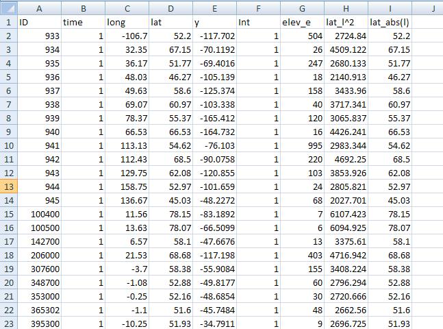
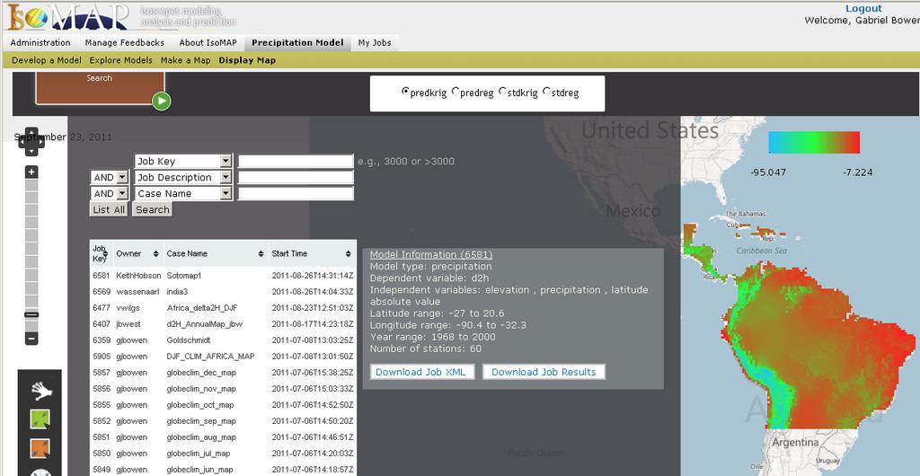
10 obs.txt
11 Algorithms - Precipitation Precipitation modeling (Geo)statistical code Develop model Apply model to predict (map) Developed by Tonglin Zhang, Purdue Dept. of Statistics Zhang et al., in prep. Poster #26 isomapstat.pdf on your thumb drive
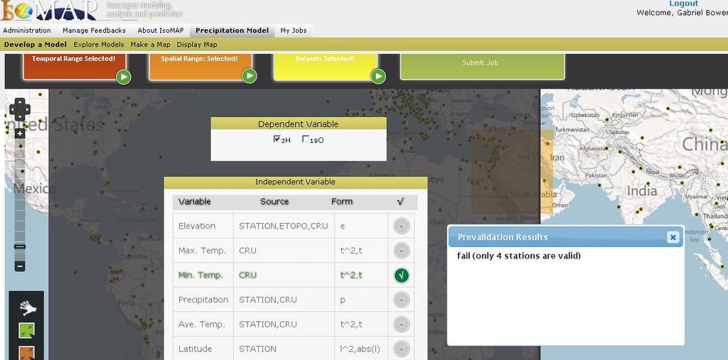
12 Algorithms - Precipitation Develop model User specifies problem Spatial Temporal Variables Two models fit to resulting dataset Multiple regression Geostatistical (universal kriging)
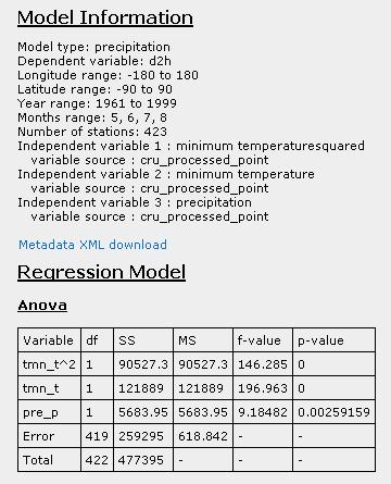
13 Algorithms - Precipitation Multiple regression Fit β given isotope station data Predict Y at unknown sites using gridded data Moran s I test of global spatial autocorrelation in є(s) Used to assess whether spatial pattern remains after regression modeling
14 Algorithms - Precipitation Geostatistical model Isotope value is considered a function of Independent variables Spatially autocorrelated residuals Fit β and model for spatial covariance (c 0, R θ ) given isotope station data Predict Y at unknown sites using gridded data
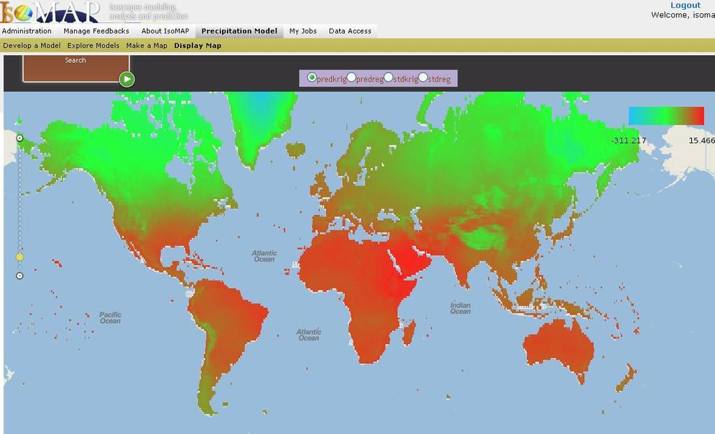
15 Algorithms - Precipitation Uncertainty Goodness of fit, parameter uncertainty and significance calculated for all models Precision of estimates given as maps of standard deviations for predictions Propagated from uncertainty in model parameters For regression: model coefficients + error term For geostatistics: model coefficients + spatially varying error term (function of station proximity) Includes nugget


16 Algorithms - Precipitation Fit regression model Moran s I Pass? Fit Geostatistical Model coeff.reg morani.reg coeff.krig mse.reg mse.krig R2.reg anova.reg anova.krig significance.reg estimate.reg estimate.krig predreg stdreg predkrig stdkrig
17 Algorithms - Assignment Assignment modeling Given precipitation isoscape and user-input sample value (+ uncertainties) Calculate relative likelihood that sample originated from any pixel on map Simple Bayesian probabilistic calculation with non-informative priors As used in Kennedy et al. (2011, Forensic Science International), after Wunder (Isoscapes, elsewhere)


18 Computation IsoMAP jobs run on NSFsupported grid computing resources Purdue s Steele cluster 893 node, 7144 processor, 67 Teraflop cluster File system network-mounted
19 Computation On submission Job specifications sent to IsoMAP server Server creates new job description, submits to Steele queue Server monitors status Submitted Pending Active Done Server post-processes results and registers them for display
20 Visualization Computational outputs in a range of custom formats Supports flexibility, program I/O Data processing scripts convert output into accessible and standard formats Text parsing Interpret statistical output Generate graphics Display
21
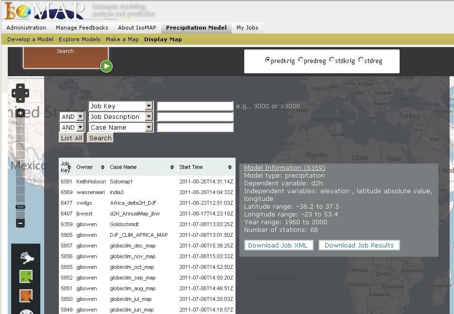
22 Visualization File conversion Tabular data -> raster Arc ASCII GeoTIFF Display Browser display using OpenLayers Color map rescale on pan and zoom
23
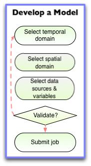
24 Graphical Workflow Browser-based user interface Organizes and guides user through steps of developing analysis, finding and visualizing results Ensures completeness Validates user inputs Provides feedback Consistent modular structure, look and feel for most implementations

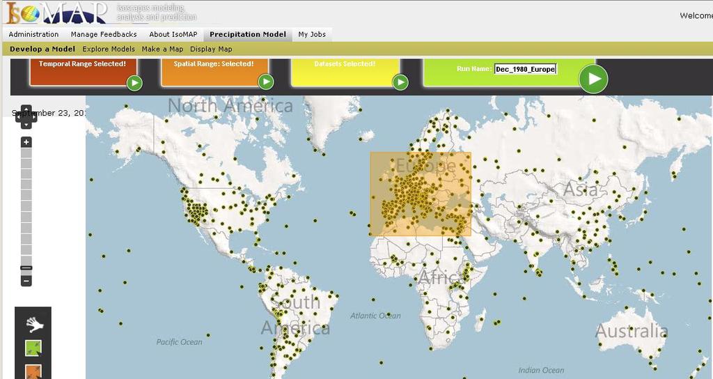
25 Precipitation Modeling Workflow

26
27
28

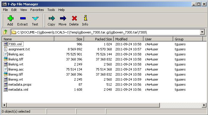
29 Documentation IsoMAP keeps track of what you have done Metadata.xml Job specifications Summary of extracted/reduced datasets Computational details Key results Home-grown format Designed to offer value to user, and Serve as an information payload within the IsoMAP system
30
31
32 Storage All your work is stored in a secure file system Accessible through your account Only you manage your jobs, you manage only your jobs Retrieve or reuse results at any time Job package downloadable Metadata Input data Raw and processed results
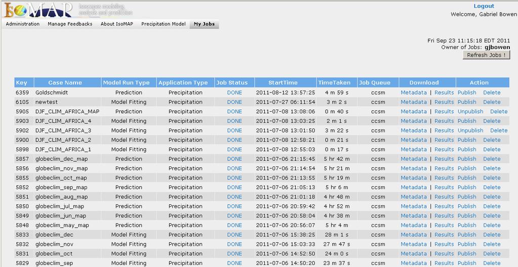
33
34
35 Sharing IsoMAP lets you publish your work, making it: Visible to others Downloadable by others Usable by others Current mechanism primitive All-or-none Local only Long-term vision includes groups, external discovery
36
37 Hierarchical Analysis IsoMAP is designed to let you build one analysis on top of another Organize your analysis workflow as modular steps Develop derived isoscapes and complex analyses using consistent, traceable methods Store and document intermediate data products Multiple entry points along the analysis workflow

38 Precipitation Modeling Workflow
39 Hierarchical Analysis Geospatial assignment Uses IsoMAP precipitation isoscapes as input Basic version prototyped Production-ready within 1-2 weeks Leaf water models Uses IsoMAP precipitation isoscapes as input Code ready, implementation to be started this fall Anticipated release spring 2012

40 δ 2 H = σ = 4.21

41 Bowen et al., in press, JGR-Biogeosciences
42 IsoMAP User Experience Design targets flexibility, accessibility, modularity That said, we ve focused 1 st on content, and quirks remain IE compatibility Shorthand notation Inefficiency with respect to user input Incomplete documentation Bugs
43 IsoMAP User Experience We are working on these issues, and hopefully will accelerate our progress as content roll-out is completed Useful resources: Documents (quick guide, statistics white paper, systems design paper see flash drive) Video tutorials (introductory video available now, more to follow) Us
44 IsoMAP 2.0? We are seeking funding to extend on our work 3 major emphases New analysis and modeling tools Support user-supplied data Link to distributed data resources The ultimate goal is to serve a broad research and education community by providing end-to-end data management and analysis tools To do this, we need your perspective, your input, and your vision
ArcGIS Enterprise: What s New. Philip Heede Shannon Kalisky Melanie Summers Shreyas Shinde
 ArcGIS Enterprise: What s New Philip Heede Shannon Kalisky Melanie Summers Shreyas Shinde ArcGIS Enterprise is the new name for ArcGIS for Server ArcGIS Enterprise Software Components ArcGIS Server Portal
Among various open-source GIS programs, QGIS can be the best suitable option which can be used across partners for reasons outlined below.
 Comparison of Geographic Information Systems (GIS) software As of January 2018, WHO has reached an agreement with ESRI (an international supplier of GIS software) for an unlimited use of ArcGIS Desktop
Administering your Enterprise Geodatabase using Python. Jill Penney
 Administering your Enterprise Geodatabase using Python Jill Penney Assumptions Basic knowledge of python Basic knowledge enterprise geodatabases and workflows You want code Please turn off or silence cell
ArcGIS Enterprise: What s New. Philip Heede Shannon Kalisky Melanie Summers Sam Williamson
 ArcGIS Enterprise: What s New Philip Heede Shannon Kalisky Melanie Summers Sam Williamson ArcGIS Enterprise is the new name for ArcGIS for Server What is ArcGIS Enterprise ArcGIS Enterprise is powerful
Search for the Gulf of Carpentaria in the remap search bar:
 This tutorial is aimed at getting you started with making maps in Remap (). In this tutorial we are going to develop a simple classification of mangroves in northern Australia. Before getting started with
Evaluating Physical, Chemical, and Biological Impacts from the Savannah Harbor Expansion Project Cooperative Agreement Number W912HZ
 Evaluating Physical, Chemical, and Biological Impacts from the Savannah Harbor Expansion Project Cooperative Agreement Number W912HZ-13-2-0013 Annual Report FY 2018 Submitted by Sergio Bernardes and Marguerite
Introduction to the 176A labs and ArcGIS Purpose of the labs
 Introduction to the 176A labs and ArcGIS Purpose of the labs Acknowledgement: Slides by David Maidment, U Texas-Austin and Francisco Olivera (TAMU) Hands-on experience with a leading software package Introduction
Watershed Application of WEPP and Geospatial Interfaces. Dennis C. Flanagan
 Watershed Application of WEPP and Geospatial Interfaces Dennis C. Flanagan Research Agricultural Engineer USDA-Agricultural Research Service Adjunct Professor Purdue Univ., Dept. of Agric. & Biol. Eng.
NR402 GIS Applications in Natural Resources
 NR402 GIS Applications in Natural Resources Lesson 1 Introduction to GIS Eva Strand, University of Idaho Map of the Pacific Northwest from http://www.or.blm.gov/gis/ Welcome to NR402 GIS Applications in
DP Project Development Pvt. Ltd.
 Dear Sir/Madam, Greetings!!! Thanks for contacting DP Project Development for your training requirement. DP Project Development is leading professional training provider in GIS technologies and GIS application
Geometric Algorithms in GIS
 Geometric Algorithms in GIS GIS Visualization Software Dr. M. Gavrilova GIS Software for Visualization ArcView GEO/SQL Digital Atmosphere AutoDesk Visual_Data GeoMedia GeoExpress CAVE? Visualization in
YYT-C3002 Application Programming in Engineering GIS I. Anas Altartouri Otaniemi
 YYT-C3002 Application Programming in Engineering GIS I Otaniemi Overview: GIS lectures & exercise We will deal with GIS application development in two lectures. Because of the versatility of GIS data models
Roger S. Bivand Edzer J. Pebesma Virgilio Gömez-Rubio. Applied Spatial Data Analysis with R. 4:1 Springer
 Roger S. Bivand Edzer J. Pebesma Virgilio Gömez-Rubio Applied Spatial Data Analysis with R 4:1 Springer Contents Preface VII 1 Hello World: Introducing Spatial Data 1 1.1 Applied Spatial Data Analysis
Introducing the WISERD Geoportal. WISERD DATA TEAM Dr Robert Berry & Dr Richard Fry, University of Glamorgan Dr Scott Orford, Cardiff University
 Introducing the WISERD Geoportal WISERD DATA TEAM Dr Robert Berry & Dr Richard Fry, University of Glamorgan Dr Scott Orford, Cardiff University WISERD What is WISERD? Wales Institute of Social and Economic
Search for the Dubai in the remap search bar:
 This tutorial is aimed at developing maps for two time periods with in Remap (). In this tutorial we are going to develop a classification water and non-water in Dubai for the year 2000 and the year 2016.
Web Visualization of Geo-Spatial Data using SVG and VRML/X3D
 Web Visualization of Geo-Spatial Data using SVG and VRML/X3D Jianghui Ying Falls Church, VA 22043, USA jying@vt.edu Denis Gračanin Blacksburg, VA 24061, USA gracanin@vt.edu Chang-Tien Lu Falls Church,
 http://www.wrcc.dri.edu/csc/scenic/ USER GUIDE 2017 Introduction... 2 Overview Data... 3 Overview Analysis Tools... 4 Overview Monitoring Tools... 4 SCENIC structure and layout... 5... 5 Detailed Descriptions
Web-GIS based Framework for Solid Waste Complaint Management for Sustainable and Smart City
 Cloud Publications International Journal of Advanced Remote Sensing and GIS 2016, Volume 5, Issue 10, pp. 1930-1936 ISSN 2320-0243, DOI: 10.23953/cloud.ijarsg.71 Research Article Open Access Web-GIS based
Using OGC standards to improve the common
 Using OGC standards to improve the common operational picture Abstract A "Common Operational Picture", or a, is a single identical display of relevant operational information shared by many users. The
BUILDING A GRIDDED CLIMATOLOGICAL DATASET FOR USE IN THE STATISTICAL INTERPRETATION OF NUMERICAL WEATHER PREDICTION MODELS
 JP 1.6 BUILDING A GRIDDED CLIMATOLOGICAL DATASET FOR USE IN THE STATISTICAL INTERPRETATION OF NUMERICAL WEATHER PREDICTION MODELS Rachel A. Trimarco, Kari L. Sheets, and Kathryn K. Hughes Meteorological
ArcGIS. for Server. Understanding our World
 ArcGIS for Server Understanding our World ArcGIS for Server Create, Distribute, and Manage GIS Services You can use ArcGIS for Server to create services from your mapping and geographic information system
Learning ArcGIS: Introduction to ArcCatalog 10.1
 Learning ArcGIS: Introduction to ArcCatalog 10.1 Estimated Time: 1 Hour Information systems help us to manage what we know by making it easier to organize, access, manipulate, and apply knowledge to the
Spatial Data Approaches to Improve Production and Reduce Risks of Impacts
 Spatial Data Approaches to Improve Production and Reduce Risks of Impacts Geospatial & Geostatistical Analyses to Improve Science-Based Decision Making Kelly Rose, Geology & Geospatial Research Lead Jennifer
Geog 469 GIS Workshop. Managing Enterprise GIS Geodatabases
 Geog 469 GIS Workshop Managing Enterprise GIS Geodatabases Outline 1. Why is a geodatabase important for GIS? 2. What is the architecture of a geodatabase? 3. How can we compare and contrast three types
Exelis and Esri Technologies for Defense and National Security. Cherie Muleh
 Exelis and Esri Technologies for Defense and National Security Cherie Muleh Cherie.Muleh@exelisinc.com ENVI IMAGERY AND DATA BECOME KNOWLEDGE > Add information from imagery to your GIS > Automated workflows
FAO GAEZ Data Portal
 FAO GAEZ Data Portal www.fao.org/nr/gaez Renato Cumani Environment Officer Land and Water Division Natural Resources Management and Environment Department Food and Agriculture Organization of the UN October
Spatial Effects on Current and Future Climate of Ipomopsis aggregata Populations in Colorado Patterns of Precipitation and Maximum Temperature
 A. Kenney GIS Project Spring 2010 Amanda Kenney GEO 386 Spring 2010 Spatial Effects on Current and Future Climate of Ipomopsis aggregata Populations in Colorado Patterns of Precipitation and Maximum Temperature
Using the EartH2Observe data portal to analyse drought indicators. Lesson 4: Using Python Notebook to access and process data
 Using the EartH2Observe data portal to analyse drought indicators Lesson 4: Using Python Notebook to access and process data Preface In this fourth lesson you will again work with the Water Cycle Integrator
Welcome! Power BI User Group (PUG) Copenhagen
 Copenhagen") Welcome! Power BI User Group (PUG) Copenhagen Making Maps in Power BI Andrea Martorana Tusa BI Specialist Welcome to Making maps in Power BI Who am I? First name: Andrea. Last name: Martorana Tusa. Italian,
Welcome! Power BI User Group (PUG) Copenhagen Making Maps in Power BI Andrea Martorana Tusa BI Specialist Welcome to Making maps in Power BI Who am I? First name: Andrea. Last name: Martorana Tusa. Italian,
Enabling the Image Analyst (IA) to use the geodatabase
 to use the geodatabase") Enabling the Image Analyst (IA) to use the geodatabase Rick Racine, BAE Systems, Reston, VA Stewart Walker, BAE Systems, San Diego, CA 2008 ESRI Federal User Conference, Washington, D.C., 21 February 2610020508
Enabling the Image Analyst (IA) to use the geodatabase Rick Racine, BAE Systems, Reston, VA Stewart Walker, BAE Systems, San Diego, CA 2008 ESRI Federal User Conference, Washington, D.C., 21 February 2610020508
Migrating Defense Workflows from ArcMap to ArcGIS Pro. Renee Bernstein and Jared Sellers
 Migrating Defense Workflows from ArcMap to ArcGIS Pro Renee Bernstein and Jared Sellers ArcGIS Desktop Desktop Web Device ArcMap ArcCatalog ArcScene ArcGlobe ArcGIS Pro portal Server Online Content and
Introduction to the 176A labs and ArcGIS
 Introduction to the 176A labs and ArcGIS Acknowledgement: Slides by David Maidment, U Texas-Austin and Francisco Olivera (TAMU) Purpose of the labs Hands-on experience with one software pakage Introduction
Geodatabase Programming with Python John Yaist
 Geodatabase Programming with Python John Yaist DevSummit DC February 26, 2016 Washington, DC Target Audience: Assumptions Basic knowledge of Python Basic knowledge of Enterprise Geodatabase and workflows
DEKDIV: A Linked-Data-Driven Web Portal for Learning Analytics Data Enrichment, Interactive Visualization, and Knowledge Discovery
 DEKDIV: A Linked-Data-Driven Web Portal for Learning Analytics Data Enrichment, Interactive Visualization, and Knowledge Discovery Yingjie Hu, Grant McKenzie, Jiue-An Yang, Song Gao, Amin Abdalla, and
Spatial Analysis with ArcGIS Pro STUDENT EDITION
 Spatial Analysis with ArcGIS Pro STUDENT EDITION Copyright 2018 Esri All rights reserved. Course version 2.0. Version release date November 2018. Printed in the United States of America. The information
Data Aggregation with InfraWorks and ArcGIS for Visualization, Analysis, and Planning
 Data Aggregation with InfraWorks and ArcGIS for Visualization, Analysis, and Planning Stephen Brockwell President, Brockwell IT Consulting, Inc. Join the conversation #AU2017 KEYWORD Class Summary Silos
Search for the Dubai in the remap search bar:
 This tutorial is aimed at developing maps for two time periods with in Remap (). In this tutorial we are going to develop a classification water and non-water in Dubai for the year 2000 and the year 2016.
Processing NOAA Observation Data over Hybrid Computer Systems for Comparative Climate Change Analysis
 Processing NOAA Observation Data over Hybrid Computer Systems for Comparative Climate Change Analysis Xuan Shi 1,, Dali Wang 2 1 Department of Geosciences, University of Arkansas, Fayetteville, AR 72701,
Geodatabase Programming with Python
 DevSummit DC February 11, 2015 Washington, DC Geodatabase Programming with Python Craig Gillgrass Assumptions Basic knowledge of python Basic knowledge enterprise geodatabases and workflows Please turn
Cloud-based WRF Downscaling Simulations at Scale using Community Reanalysis and Climate Datasets
 Cloud-based WRF Downscaling Simulations at Scale using Community Reanalysis and Climate Datasets Luke Madaus -- 26 June 2018 luke.madaus@jupiterintel.com 2018 Unidata Users Workshop Outline What is Jupiter?
Analyzing the Earth Using Remote Sensing
 Analyzing the Earth Using Remote Sensing Instructors: Dr. Brian Vant- Hull: Steinman 185, 212-650- 8514 brianvh@ce.ccny.cuny.edu Ms. Hannah Aizenman: NAC 7/311, 212-650- 6295 haizenman@ccny.cuny.edu Dr.
Inquiry: The University of Arkansas Undergraduate Research Journal. Volume 5 Article 15
 Inquiry: The University of Arkansas Undergraduate Research Journal Volume 5 Article 15 Fall 2004 Last Frost Project Midori Kubozono University of Arkansas, Fayetteville Follow this and additional works
INTRODUCTION TO GEOGRAPHIC INFORMATION SYSTEM By Reshma H. Patil
 INTRODUCTION TO GEOGRAPHIC INFORMATION SYSTEM By Reshma H. Patil ABSTRACT:- The geographical information system (GIS) is Computer system for capturing, storing, querying analyzing, and displaying geospatial
POSITION DESCRIPTION. Position Title: Geographic Information Systems (GIS) Coordinator Department: Engineering
 Coordinator Department: Engineering") POSITION DESCRIPTION Position Title: Geographic Information Systems (GIS) Coordinator Department: Engineering Reports To: Engineering Supervisor FLSA Status: Exempt Date: April 2018 PRIMARY OBJECTIVE OF
POSITION DESCRIPTION Position Title: Geographic Information Systems (GIS) Coordinator Department: Engineering Reports To: Engineering Supervisor FLSA Status: Exempt Date: April 2018 PRIMARY OBJECTIVE OF
The Case for Use Cases
 The Case for Use Cases The integration of internal and external chemical information is a vital and complex activity for the pharmaceutical industry. David Walsh, Grail Entropix Ltd Costs of Integrating
February 7, Jay Krafthefer, L.S.
 February 7, 2013 Jay Krafthefer, L.S. Introduction Background Web applications References Maps released on the Internet self-service not filed for record referenced by Commissioner s orders (Minn. Statute
Outline. Chapter 1. A history of products. What is ArcGIS? What is GIS? Some GIS applications Introducing the ArcGIS products How does GIS work?
 Outline Chapter 1 Introducing ArcGIS What is GIS? Some GIS applications Introducing the ArcGIS products How does GIS work? Basic data formats The ArcCatalog interface 1-1 1-2 A history of products Arc/Info
Dear Teacher, Overview Page 1
 Dear Teacher, You are about to involve your students in one of the most exciting frontiers of science the search for other worlds and life in solar systems beyond our own! Using the MicroObservatory telescopes,
FUNDAMENTALS OF GEOINFORMATICS PART-II (CLASS: FYBSc SEM- II)
") FUNDAMENTALS OF GEOINFORMATICS PART-II (CLASS: FYBSc SEM- II) UNIT:-I: INTRODUCTION TO GIS 1.1.Definition, Potential of GIS, Concept of Space and Time 1.2.Components of GIS, Evolution/Origin and Objectives
FUNDAMENTALS OF GEOINFORMATICS PART-II (CLASS: FYBSc SEM- II) UNIT:-I: INTRODUCTION TO GIS 1.1.Definition, Potential of GIS, Concept of Space and Time 1.2.Components of GIS, Evolution/Origin and Objectives
Geoprovisioning delivers geodata and its analysis for specific areas on request.
 DRAFT 27 February 2009 Geoprovisioning Geoprovisioning delivers geodata and its analysis for specific areas on request. What are the components of a geoprovisioning service? The sample web site geoprovisioning.com
Measuring earthquake-generated surface offsets from high-resolution digital topography
 Measuring earthquake-generated surface offsets from high-resolution digital topography July 19, 2011 David E. Haddad david.e.haddad@asu.edu Active Tectonics, Quantitative Structural Geology, and Geomorphology
Overview of Geospatial Open Source Software which is Robust, Feature Rich and Standards Compliant
 Overview of Geospatial Open Source Software which is Robust, Feature Rich and Standards Compliant Cameron SHORTER, Australia Key words: Open Source Geospatial Foundation, OSGeo, Open Standards, Open Geospatial
Search for a location using the location search bar:
 Remap () is an online mapping platform for people with little technical background in remote sensing. We developed remap to enable you to quickly map and report the status of ecosystems, contributing to
The Challenge of Geospatial Big Data Analysis
 288 POSTERS The Challenge of Geospatial Big Data Analysis Authors - Teerayut Horanont, University of Tokyo, Japan - Apichon Witayangkurn, University of Tokyo, Japan - Shibasaki Ryosuke, University of Tokyo,
ArcGIS Pro Q&A Session. NWGIS Conference, October 11, 2017 With John Sharrard, Esri GIS Solutions Engineer
 ArcGIS Pro Q&A Session NWGIS Conference, October 11, 2017 With John Sharrard, Esri GIS Solutions Engineer jsharrard@esri.com ArcGIS Desktop The applications ArcGIS Pro ArcMap ArcCatalog ArcScene ArcGlobe
European Commission STUDY ON INTERIM EVALUATION OF EUROPEAN MARINE OBSERVATION AND DATA NETWORK. Executive Summary
 European Commission STUDY ON INTERIM EVALUATION OF EUROPEAN MARINE OBSERVATION AND DATA NETWORK Executive Summary by NILOS Netherlands Institute for the Law of the Sea June 2011 Page ii Study on Interim
What is CERA? Coastal Emergency Risks Assessment
 What is CERA? Coastal Emergency Risks Assessment Visualization tool using OGC standards Displays the outputs from the ADCIRC storm surge model or other coastal models Represents the maps on interactive
This tutorial is intended to familiarize you with the Geomatica Toolbar and describe the basics of viewing data using Geomatica Focus.
 PCI GEOMATICS GEOMATICA QUICKSTART 1. Introduction This tutorial is intended to familiarize you with the Geomatica Toolbar and describe the basics of viewing data using Geomatica Focus. All data used in
The GeoCLIM software for gridding & analyzing precipitation & temperature. Tamuka Magadzire, FEWS NET Regional Scientist for Southern Africa
 The GeoCLIM software for gridding & analyzing precipitation & temperature Tamuka Magadzire, FEWS NET Regional Scientist for Southern Africa Outline What is GeoCLIM GeoCLIM Development Team GeoCLIM: objectives
GeoWEPP Tutorial Appendix
 GeoWEPP Tutorial Appendix Chris S. Renschler University at Buffalo - The State University of New York Department of Geography, 116 Wilkeson Quad Buffalo, New York 14261, USA Prepared for use at the WEPP/GeoWEPP
Outline. Introduction to SpaceStat and ESTDA. ESTDA & SpaceStat. Learning Objectives. Space-Time Intelligence System. Space-Time Intelligence System
 Outline I Data Preparation Introduction to SpaceStat and ESTDA II Introduction to ESTDA and SpaceStat III Introduction to time-dynamic regression ESTDA ESTDA & SpaceStat Learning Objectives Activities
EEOS 381 -Spatial Databases and GIS Applications
 EEOS 381 -Spatial Databases and GIS Applications Lecture 5 Geodatabases What is a Geodatabase? Geographic Database ESRI-coined term A standard RDBMS that stores and manages geographic data A modern object-relational
Implementing Visual Analytics Methods for Massive Collections of Movement Data
 Implementing Visual Analytics Methods for Massive Collections of Movement Data G. Andrienko, N. Andrienko Fraunhofer Institute Intelligent Analysis and Information Systems Schloss Birlinghoven, D-53754
GIS Data Structure: Raster vs. Vector RS & GIS XXIII
 Subject Paper No and Title Module No and Title Module Tag Geology Remote Sensing and GIS GIS Data Structure: Raster vs. Vector RS & GIS XXIII Principal Investigator Co-Principal Investigator Co-Principal
An Instructional Module. FieldScope Unit 1. Introduction to National Geographic Society s FieldScope Program.
 An Instructional Module FieldScope Unit 1 www.budburst.org/fieldscope Introduction to National Geographic Society s FieldScope Program Unit Contents Overview 3 Learning Objectives Time Commitment Technical
Dr. Stephen J. Walsh Department of Geography, UNC-CH Fall, 2007 Monday 3:30-6:00 pm Saunders Hall Room 220. Introduction
 Geographic Information Systems Geography 491 Dr. Stephen J. Walsh Department of Geography, UNC-CH Fall, 2007 Monday 3:30-6:00 pm Saunders Hall Room 220 Introduction Organizations that have a planning,
Data Structures & Database Queries in GIS
 Data Structures & Database Queries in GIS Objective In this lab we will show you how to use ArcGIS for analysis of digital elevation models (DEM s), in relationship to Rocky Mountain bighorn sheep (Ovis
ArcGIS Pro: Analysis and Geoprocessing. Nicholas M. Giner Esri Christopher Gabris Blue Raster
 ArcGIS Pro: Analysis and Geoprocessing Nicholas M. Giner Esri Christopher Gabris Blue Raster Agenda What is Analysis and Geoprocessing? Analysis in ArcGIS Pro - 2D (Spatial xy) - 3D (Elevation - z) - 4D
Geometric Algorithms in GIS
 Geometric Algorithms in GIS GIS Software Dr. M. Gavrilova GIS System What is a GIS system? A system containing spatially referenced data that can be analyzed and converted to new information for a specific
Understanding Geographic Information System GIS
 Understanding Geographic Information System GIS What do we know about GIS? G eographic I nformation Maps Data S ystem Computerized What do we know about maps? Types of Maps (Familiar Examples) Street Maps
QGIS FLO-2D Integration
 EPiC Series in Engineering Volume 3, 2018, Pages 1575 1583 Engineering HIC 2018. 13th International Conference on Hydroinformatics Karen O Brien, BSc. 1, Noemi Gonzalez-Ramirez, Ph. D. 1 and Fernando Nardi,
Performing Advanced Cartography with Esri Production Mapping
 Esri International User Conference San Diego, California Technical Workshops July 25, 2012 Performing Advanced Cartography with Esri Production Mapping Tania Pal & Madhura Phaterpekar Agenda Outline generic
GIS-T 2010 Building a Successful Geospatial Data Sharing Framework: A Ohio DOT Success Story
 GIS-T 2010 Building a Successful Geospatial Data Sharing Framework: A Ohio DOT Success Story ODOT District 2 GIS John Puente District 1 GIS Coordinator\ Planning Administrator 2 Interoperability 3 District
Westmap: The Western Climate Mapping Initiative An Update
 Westmap: The Western Climate Mapping Initiative An Update Andrew Comrie 1, Kelly Redmond 2, Mary Glueck 1, Hauss Reinbold 3, Chris Daly 4 1 University of Arizona, 2 DRI / Western Regional Climate Center
Arcmap Manual Esri 10 READ ONLINE
 Arcmap Manual Esri 10 READ ONLINE Esri Store: Browsing ArcPad 10.2.2 - ArcPad is mobile field mapping and data collection software designed for GIS professionals. It includes advanced GIS and GPS capabilities
NSIDC Metrics Report. Lisa Booker February 9, 2012
 NSIDC Metrics Report Lisa Booker February 9, 2012 ACSI Scores 2011 ACSI survey summary Sent to 5458 users; increased number of users contacted NSIDC response rate was 10%, up 1% from last year. NSIDC Customer
Arcmap Manual Esri 10 READ ONLINE
 Arcmap Manual Esri 10 READ ONLINE If searching for a book Arcmap manual esri 10 in pdf form, then you have come on to the loyal site. We present the utter release of this book in PDF, doc, DjVu, epub,
Delineation of Watersheds
 Delineation of Watersheds Adirondack Park, New York by Introduction Problem Watershed boundaries are increasingly being used in land and water management, separating the direction of water flow such that
Karsten Vennemann, Seattle. QGIS Workshop CUGOS Spring Fling 2015
 Karsten Vennemann, Seattle 2015 a very capable and flexible Desktop GIS QGIS QGIS Karsten Workshop Vennemann, Seattle slide 2 of 13 QGIS - Desktop GIS originally a GIS viewing environment QGIS for the
AN INTERNATIONAL SOLAR IRRADIANCE DATA INGEST SYSTEM FOR FORECASTING SOLAR POWER AND AGRICULTURAL CROP YIELDS
 AN INTERNATIONAL SOLAR IRRADIANCE DATA INGEST SYSTEM FOR FORECASTING SOLAR POWER AND AGRICULTURAL CROP YIELDS James Hall JHTech PO Box 877 Divide, CO 80814 Email: jameshall@jhtech.com Jeffrey Hall JHTech
StreamStats: Delivering Streamflow Information to the Public. By Kernell Ries
 StreamStats: Delivering Streamflow Information to the Public By Kernell Ries U.S. Department of the Interior U.S. Geological Survey MD-DE-DC District 410-238-4317 kries@usgs.gov StreamStats Web Application
Navigating to Success: Finding Your Way Through the Challenges of Map Digitization
 Library Faculty Presentations Library Faculty/Staff Scholarship & Research 10-15-2011 Navigating to Success: Finding Your Way Through the Challenges of Map Digitization Cory K. Lampert University of Nevada,
Introduction to GIS I
 Introduction to GIS Introduction How to answer geographical questions such as follows: What is the population of a particular city? What are the characteristics of the soils in a particular land parcel?
INTRODUCTION TO GIS. Dr. Ori Gudes
 INTRODUCTION TO GIS Dr. Ori Gudes Outline of the Presentation What is GIS? What s the rational for using GIS, and how GIS can be used to solve problems? Explore a GIS map and get information about map
Hurricanes Katrina and Rita created the largest natural disaster in American history
 Overview of the Road Home Program Hurricanes Katrina and Rita created the largest natural disaster in American history In Louisiana: 123,000 homes suffered major damage 82,000 rental properties suffered
Geoprocessing Tools at ArcGIS 9.2 Desktop
 Geoprocessing Tools at ArcGIS 9.2 Desktop Analysis Tools Analysis Tools \ Extract Clip Analysis Tools \ Extract Select Analysis Tools \ Extract Split Analysis Tools \ Extract Table Select Analysis Tools
Steve Pietersen Office Telephone No
 Steve Pietersen Steve.Pieterson@durban.gov.za Office Telephone No. 031 311 8655 Overview Why geography matters The power of GIS EWS GIS water stats EWS GIS sanitation stats How to build a GIS system EWS
Water Atlas Overview. Myakka River Management Coordinating Council June 22, 2012 Englewood, Florida
 Water Atlas Overview Myakka River Management Coordinating Council June 22, 2012 Englewood, Florida What is the Water Atlas? A data warehouse A set of interactive maps A collection of tools for viewing/analyzing
Geostatistics and Spatial Scales
 Geostatistics and Spatial Scales Semivariance & semi-variograms Scale dependence & independence Ranges of spatial scales Variable dependent Fractal dimension GIS implications Spatial Modeling Spatial Analysis
MeteoSwiss Spatial Climate Analyses: Documentation of Datasets for Users
 Federal Department of Home Affairs FDHA Federal Office of Meteorology and Climatology MeteoSwiss MeteoSwiss Spatial Climate Analyses: Documentation of Datasets for Users Figure 1: Distribution of the 48-hour
Enabling ENVI. ArcGIS for Server
 Enabling ENVI throughh ArcGIS for Server 1 Imagery: A Unique and Valuable Source of Data Imagery is not just a base map, but a layer of rich information that can address problems faced by GIS users. >
A Web Portal for Regional Projection of Weather Forecast Using GRID Middleware
 A Web Portal for Regional Projection of Weather Forecast Using GRID Middleware A.S. Cofiño, D. San-Martín, and J.M. Gutiérrez Dept. of Applied Mathematics and Computer Science, University of Cantabria.
Using R for time series analysis and spatial-temporal distribution of global burnt surface multi-year product
 Using R for time series analysis and spatial-temporal distribution of global burnt surface multi-year product Jedrzej Bojanowski* César Carmona-Moreno European Commission - Joint Research Centre Institute
Evaluating Physical, Chemical, and Biological Impacts from the Savannah Harbor Expansion Project Cooperative Agreement Number W912HZ
 Evaluating Physical, Chemical, and Biological Impacts from the Savannah Harbor Expansion Project Cooperative Agreement Number W912HZ-13-2-0013 Second Quarterly Report - 2017 Submitted by Sergio Bernardes
Large Scale Evaluation of Chemical Structure Recognition 4 th Text Mining Symposium in Life Sciences October 10, Dr.
 Large Scale Evaluation of Chemical Structure Recognition 4 th Text Mining Symposium in Life Sciences October 10, 2006 Dr. Overview Brief introduction Chemical Structure Recognition (chemocr) Manual conversion
CalWeedMapper. Mapping the Spread of Invasive Plant Species. Karsten Vennemann. Seattle
 CalWeedMapper Mapping the Spread of Invasive Plant Species Karsten Vennemann Seattle Talk Overview The CalWeedMapper Project this presentation is about the expert online editing tool (part of larger project)
Geog 210C Spring 2011 Lab 6. Geostatistics in ArcMap
 Geog 210C Spring 2011 Lab 6. Geostatistics in ArcMap Overview In this lab you will think critically about the functionality of spatial interpolation, improve your kriging skills, and learn how to use several
Operational Hydrologic Ensemble Forecasting. Rob Hartman Hydrologist in Charge NWS / California-Nevada River Forecast Center
 Operational Hydrologic Ensemble Forecasting Rob Hartman Hydrologist in Charge NWS / California-Nevada River Forecast Center Mission of NWS Hydrologic Services Program Provide river and flood forecasts
Overview Objectives Materials Background Activity Procedure
 Overview In this activity, students will explore how to determine how to assemble information about plant distributions, and relate those distributional to the environment by assembling information on
GIS Boot Camp for Education June th, 2011 Day 1. Instructor: Sabah Jabbouri Phone: (253) x 4854 Office: TC 136
 x 4854 Office: TC 136") GIS Boot Camp for Education June 27-30 th, 2011 Day 1 Instructor: Sabah Jabbouri Phone: (253) 833-9111 x 4854 Office: TC 136 Email: sjabbouri@greenriver.edu http://www.instruction.greenriver.edu/gis/ Summer
GIS Boot Camp for Education June 27-30 th, 2011 Day 1 Instructor: Sabah Jabbouri Phone: (253) 833-9111 x 4854 Office: TC 136 Email: sjabbouri@greenriver.edu http://www.instruction.greenriver.edu/gis/ Summer